Memo. 1.0 Introduction
|
|
|
- Myrtle Wood
- 5 years ago
- Views:
Transcription
1 Memo Wetland, Wildlife & Vegetation Specialists To: Steve Rogers, Golder Associates From: Andy Herb, AlpineEco CC: Date: August 31, 2015 Re: Boxelder Dam Sites B2 and B3: Results of Vegetation, Wetlands, and TES Habitat Field Survey 1.0 Introduction North Poudre Irrigation Company (NPIC) was an original sponsor of the Boxelder Creek Watershed Project that constructed five flood control dams in the 1970s and early 1980s. Two of these dams, Boxelder Creek Watershed Dams B2 and B3 (ure 1) were originally constructed to protect agricultural land in north central Colorado from flooding. After 35 years of population growth and land development, these rural dams now protect highly developed areas of unincorporated Larimer County, Wellington, Timnath, and parts of eastern Fort Collins. In July 2013, the Colorado Division of Water Resources/Dam Safety Branch raised the hazard classification of both dams from significant to high. The Boxelder B2 and B3 dams are now required to meet higher state and federal dam safety standards (NPIC 2015). In May 2015, a watershed planning study was begun to evaluate alternatives for rehabilitating the dams to serve current needs and meet higher dam safety standards. As part of the study, AlpineEco investigated the sites for the presence of wetlands and other waters features, Colorado-listed noxious weeds, and habitat for plants listed as federally threatened and endangered species (TES). This memo provides a very brief summary of the findings. 2.0 Methods On June 18, 2015, Andy Herb (senior ecologist) walked both sites to identify and map the habitats present, record noxious weeds, and investigate the sites for potential habitat for TES plants. Wetlands were mapped based on the presence of hydrophytic vegetation, which is a conservative approach since both hydric soils and wetland hydrology were assumed to be present. A formal wetland delineation was not conducted. The presence and relative abundance of all Colorado-listed noxious weeds (CDOA 2015) observed was recorded in the field. No detailed mapping of weeds was conducted. For the purposes of this project, TES plants include those listed as threatened or endangered by the US Fish and Wildlife Service. For Larimer County, these include Colorado butterfly plant (Gaura neomexicana ssp. coloradensis) and Ute ladies -tresses (Spiranthes diluvialis), both of which prefer somewhat wet/subirrigated habitats (wetlands) that are not too shaded and/or overgrown. All field mapping was done on 1 inch equals 200-foot scale color aerial photographs and digitized using ArcGIS software. All botanical nomenclature in this memo, unless otherwise noted, follows the PLANTS Database (NRCS 2015). AlpineEco ٠ 1127 Adams Street ٠ Denver, CO ٠
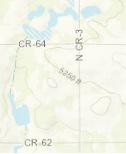
2 3.0 Results The results from the field survey are presented in the following sections. ure 2 shows Dam Site B2 (Boxelder Creek) and ure 3 shows Dam Site B3 (Coal Creek). Photos of Dam Site B2 are in Attachment A and photos of Dam Site B3 are in Attachment B. 3.1 Dam Site B2 (Boxelder Creek) The acre study area for Dam Site B2 is located approximately 8 miles northwest of the town of Wellington, Colorado in Larimer County, just southeast of the intersection of County Road (CR) 15 and Buckeye Road (ure 2). The site is situated immediately downstream of the confluence of Boxelder Creek and Rawhide Creek, and contains a portion of Boxelder Creek (both above and below the dam). The area upstream of the dam is heavily grazed and this reach of Boxelder Creek is very degraded. The channel appears to have been straightened and/or dredged, and is approximately 10 feet below the surrounding grade with nearly vertical banks. The area along the channel is dominated by weedy vegetation and no wetlands are present. Boxelder Creek below the dam appears to have been disturbed and reconstructed as part of the installation of the dam, and is very straight and deep as a result of more recent dredging. Substantial wetlands are present in this area. The site contains four main habitats or land cover types (USGS 2000), including disturbed grasslands, open water, human developments, and wetlands. The overwhelming majority of the site (93.1 percent) is covered by disturbed grasslands, which includes the dam embankment. Most of the remaining area is covered by open water associated with Boxelder Creek (4.4 percent). Table 1 lists the four habitats present, their size, and a general description. Table 1: Habitats Found in the B2 Dam Site Study Area Land Cover Type 1 Area (acres) Percent of Study Area Disturbed Grassland General Description Mainly disturbed short- or mid-grass prairie; dominated by non-natives Open Water Standing or flowing water, including ponds, streams, ditches, and canals Human Developments Mostly unvegetated; dirt roads, pavement, concrete, etc. Wetland Mostly PEM wetlands; some PSS Total Land Cover Types are based on the Colorado Gap Analysis Project (USGS 2000) Disturbed grassland areas dominate the B2 study area (ure 2) and were likely short- or mid-grass prairie that were disturbed by previous activities/land uses. This includes the dam embankment itself as well as most of the surrounding lands that were grazed, farmed, used as borrow sites, or otherwise disturbed. This cover type is dominated by non-native grasses, namely smooth brome (Bromus inermis) and crested wheatgrass (Agropyron cristatum). Other common species include sweetclover (Melilotus officinalis), western wheatgrass (Pascopyrum smithii), cheatgrass (Bromus tectorum), field bindweed (Convolvulus arvensis), curlycup gumweed (Grindelia squarrosa), blue grama (Bouteloua gracilis), buffalograss (Bouteloua dactyloides), and sand dropseed (Sporobolus cryptandrus). Most of this cover type that is not part of the dam embankment is currently grazed by cattle. Some black-tailed prairie dogs are also present. Page 2
3 Wetlands in the B2 study area are confined to the areas below the dam. Most of the wetlands are associated with Boxelder Creek, including the large backwater area below the spillway (ure 2). There are two wetland types in the study area, including palustrine emergent (PEM) and palustrine scrub-shrub (PSS). PEM wetlands are those dominated by herbaceous vegetation (grasses, grass-likes, and forbs) and PSS wetlands are those dominated by shrubs or trees less than 20 feet tall (Cowardin, et al. 1979). PEM wetlands in the study area are mostly dominated by common threesquare (Schoenoplectus pungens), Nebraska sedge (Carex nebrascensis), meadow foxtail (Alopecurus pratensis), common spikerush (Eleocharis palustris), softstem bulrush (Schoenoplectus tabernaemontani), and cattail (Typha spp.). PSS wetlands are mostly dominated by narrowleaf willow (Salix exigua), with some peachleaf willow (Salix amygdaloides). Some habitat for TES plants is present in these wetlands. Many Colorado-listed noxious weeds (CDOA 2015) were observed in the B2 study area during the brief site visit. These are listed in Table 2 along with their status, relative abundance, and general habitat preferences. Table 2: Noxious Weeds Found in the B2 Dam Site Study Area 1 Common Name Scientific Name General Habitat General Distribution in Appropriate Habitats 2 List B Species Hoary cress (whitetop) Cardaria draba Riparian habitats and moist areas Abundant Musk thistle Carduus nutans Open, upland areas Common Diffuse knapweed Centaurea diffusa Open, upland areas Common Canada thistle Cirsium arvense Riparian habitats and moist areas Abundant Russian olive Elaeagnus angustifolia Riparian habitats and moist areas Few Redstem filaree Erodium cicutarium Open, upland areas Abundant Leafy spurge Euphorbia esula Riparian habitats and moist areas Few Dalmatian toadflax Linaria dalmatica Open, upland areas Few List C Species Downy brome (cheatgrass) Bromus tectorum Open, upland areas Abundant Field bindweed Convolvulus arvensis Open, upland areas Abundant Quackgrass Elytrigia repens Riparian habitats and moist areas Abundant Common mullein Verbascum thapsus Open, upland areas Few 1 Nomenclature from CDOA 2015; no List A species observed 2 General distribution guidelines: few = <1 cover; common = 1 to 5 cover; abundant = >5 cover Page 3
4 3.2 Dam Site B3 (Coal Creek) The 59.6-acre study area for Dam Site B3 is located approximately 6 miles north of the town of Wellington, Colorado in Larimer County, just northeast of the intersection of CR 7 and Hackamore Road (ure 3). The study area contains a portion of Coal Creek (below the dam), which is a tributary to Boxelder Creek. The creek in this area is vegetated and contains wetlands, but does not have a defined channel. The site contains three main habitats or land cover types (USGS 2000), including disturbed grasslands, wetlands, and human developments. Nearly the entire site (99.3 percent) is covered by disturbed grasslands, which includes the dam embankment and spillway. Most of the remaining area is wetland associated with Coal Creek (0.5 percent). Table 3 lists the three habitats present, their size, and a general description. Table 3: Habitats Found in the B3 Dam Site Study Area Land Cover Type 1 Area (acres) Percent of Study Area Disturbed Grassland General Description Mainly disturbed short- or mid-grass prairie; dominated by non-natives Wetland PEM wetlands Human Developments Mostly unvegetated; mainly dirt roads Total Land Cover Types are based on the Colorado Gap Analysis Project (USGS 2000) Disturbed grassland areas dominate the B3 study area (ure 3) and are very similar to those found at the B2 site. They were likely short- or mid-grass prairie that were disturbed by previous activities/land uses. This includes the dam embankment and spillway as well as most of the surrounding lands that were grazed, farmed, used as borrow sites, or otherwise disturbed. This cover type is dominated by non-native species, especially crested wheatgrass (Agropyron cristatum) on the north-facing slopes and burningbush (Bassia scoparia) on the south-facing slopes. Other common species include many of those observed at the B2 site as well as sideoats grama (Bouteloua curtipendula) and widely scattered shrubs. Wetlands in the B3 study area are confined to Coal Creek below the dam (ure 3). These are PEM wetlands dominated by broadleaf cattail (Typha latifolia) and common spikerush. Other common wetland plants include foxtail barley (Hordeum jubatum), curly dock (Rumex crispus), and meadow foxtail. Some limited habitat for TES plants is present in these wetlands. Four Colorado-listed noxious weeds (CDOA 2015) were observed in the B3 study area during the brief site visit. These are listed in Table 4 along with their status, relative abundance, and general habitat preferences. Page 4
5 Table 4: Noxious Weeds Found in the B3 Dam Site Study Area 1 Common Name Scientific Name General Habitat General Distribution in Appropriate Habitats 2 List B Species Canada thistle Cirsium arvense Riparian habitats and moist areas Common Dalmatian toadflax Linaria dalmatica Open, upland areas Few List C Species Downy brome (cheatgrass) Bromus tectorum Open, upland areas Common Field bindweed Convolvulus arvensis Open, upland areas Common 1 Nomenclature from CDOA 2015; no List A species observed 2 General distribution guidelines: few = <1 cover; common = 1 to 5 cover; abundant = >5 cover 4.0 Conclusions Dam Site B2 is on Boxelder Creek (just below its confluence with Rawhide Creek) and covers approximately acres. It is over 93 percent disturbed grassland which is dominated by non-native plant species. Approximately 1.4 acres of wetlands are present below the dam. These wetlands contain potential TES plant habitat. Boxelder Creek upstream of the dam is badly degraded and does not contain wetlands. Many noxious weed species are present throughout the study area. Dam Site B3 is on Coal Creek (a tributary to Boxelder Creek) and covers approximately 59.6 acres. Over 99 percent of the site is disturbed grassland and only 0.3 acre of wetlands are present (below the dam only). The wetlands contain some limited potential TES plant habitat. Four noxious weed species are present in the study area. 5.0 Recommendations If ground disturbing activities are planned for either site, a formal wetland delineation will be required by the US Army Corps of Engineers (Corps) as part of the Section 404 of the Clean Water Act permitting process. The delineation should be done during the growing season and securing a permit (depending on the nature of the activity) could take upwards of a year. The permit application must include information on how the project will not adversely affect cultural resources or TES. Any wetlands permanently lost as a result of the project must be replaced (compensatory mitigation). This can be done on- or off-site. Presence/absence surveys for both TES plants (Colorado butterfly plant and Ute ladies -tresses) will be required to ensure compliance with the Endangered Species Act. The survey should take place in late July/early August when the plants are flowering. Results of the survey should be included with the Section 404 permit application. If plants are found in the planned impact area and cannot be avoided, further coordination will be required with the Corps and US Fish and Wildlife Service. A Noxious Weed Management Plan should be prepared for the project in order to ensure proper management of noxious weed before, during, and after construction. Page 5
6 6.0 Literature Cited Colorado Department of Agriculture (CDOA) Noxious weed website: Accessed in August. Cowardin, Lewis M., Virginia Carter, Francis C. Golet, and Edward T. LaRoe Classification of Wetlands and Deepwater Habitats of the United States. U.S. Department of the Interior, Fish and Wildlife Service, FWS/OBS-79/31. Natural Resources Conservation Service (NRCS) PLANTS Database website: Accessed in August. North Poudre Irrigation Company (NPIC) Website: Accessed in August. US Geological Survey (USGS) Colorado Gap Analysis Project: A Geographic Approach to Planning for Biological Diversity. The Mid-Continent Ecological Science Center of the USGS Biological Resources Division. In partnership with Colorado Division of Wildlife and University of Wyoming. Page 6


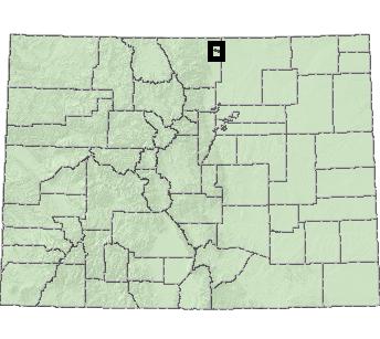
7 MainMap Extent! Fort Collins! Denver! Grand Junction! Pueblo! Durango B2 Dam Site B3 Dam Site Larimer County Weld County 87 Wellington Miles 08/30/2015 Boxelder Dams ure 1 Location Map


 Human")
 Water (5.")
 Detail")


8 Rawhide Creek FLOW 2-3 Boxelder Creek 2-1 FLOW Boxelder Creek Legend Vegetation Disturbed Grassland (123.5 acres) Human Developments (1.8 acres) Water (5.9 acres) Wetland (1.4 acres) Detail Map Extent Study Area ,000 1,500 Feet 08/30/2015 Boxelder Dams ure 2 B2 Dam Site Overview Map
9 Rawhide Creek FLOW Boxelder Creek FLOW Legend Disturbed Grassland (123.5 acres) Human Developments (1.8 acres) Water (5.9 acres) Wetland (1.4 acres) Study Area Photo Point Feet 1 in = 200 ft Boxelder Dams ure 2-1 B2 Dam Site Vegetation 08/30/2015
10 Legend Disturbed Grassland (123.5 acres) Human Developments (1.8 acres) Water (5.9 acres) Wetland (1.4 acres) Study Area Photo Point Feet 1 in = 200 ft Boxelder Dams ure 2-2 B2 Dam Site Vegetation 08/30/2015
11 Legend Disturbed Grassland (123.5 acres) Human Developments (1.8 acres) Water (5.9 acres) Wetland (1.4 acres) Study Area Photo Point Feet 1 in = 200 ft Boxelder Dams ure 2-3 B2 Dam Site Vegetation 08/30/2015
12 Boxelder Creek FLOW Legend Disturbed Grassland (123.5 acres) Human Developments (1.8 acres) Water (5.9 acres) Wetland (1.4 acres) Study Area Photo Point Feet 1 in = 200 ft Boxelder Dams ure 2-4 B2 Dam Site Vegetation 08/30/2015

 Human Developments")
 Detail Map Extent")

13 FLOW Coal Creek Legend Vegetation Disturbed Grassland (59.2 acres) Human Developments (0.1 acre) Wetland (0.3 acre) Detail Map Extent Study Area ,000 1,500 Feet 08/30/2015 Boxelder Dams ure 3 B3 Dam Site Overview Map
14 Legend Disturbed Grassland (59.2 acres) Human Developments (0.1 acre) Wetland (0.3 acre) Study Area Photo Point Feet 1 in = 200 ft Boxelder Dams ure 3-1 B3 Dam Site Vegetation 08/30/2015
15 Coal Creek FLOW Legend Disturbed Grassland (59.2 acres) Human Developments (0.1 acre) Wetland (0.3 acre) Study Area Photo Point Feet 1 in = 200 ft Boxelder Dams ure 3-2 B3 Dam Site Vegetation 08/30/2015
16 Attachment A B2 Dam Site Photographs


17 Attachment A B2 Dam Site Photographs Photo 1: Disturbed grasslands upstream of dam, looking west Photo 2: Disturbed grasslands on dam, looking east C:\Users\Andy\Desktop\AlpineEco\Projects\ Boxelder Dams\Submittal\ B2 Dam Site Photo Log.doc 1


18 Attachment A B2 Dam Site Photographs Photo 3: Disturbed grasslands downstream of dam, looking southeast Photo 4: Disturbed grasslands downstream of dam, looking east C:\Users\Andy\Desktop\AlpineEco\Projects\ Boxelder Dams\Submittal\ B2 Dam Site Photo Log.doc 2
 Photo 6: Boxelder Creek upstream of")

19 Attachment A B2 Dam Site Photographs Photo 5: Boxelder Creek upstream of dam, looking southeast (downstream) Photo 6: Boxelder Creek upstream of dam, looking northwest (upstream) C:\Users\Andy\Desktop\AlpineEco\Projects\ Boxelder Dams\Submittal\ B2 Dam Site Photo Log.doc 3
 Photo 8: Boxelder Creek below")

20 Attachment A B2 Dam Site Photographs Photo 7: Boxelder Creek below dam, looking southeasst (downstream) Photo 8: Boxelder Creek below dam, looking northwest (upstream) C:\Users\Andy\Desktop\AlpineEco\Projects\ Boxelder Dams\Submittal\ B2 Dam Site Photo Log.doc 4
 Photo 10: Irrigation ditch below")

21 Attachment A B2 Dam Site Photographs Photo 9: Boxelder Creek below dam, looking southeast (downstream) Photo 10: Irrigation ditch below dam, looking south (downstream) C:\Users\Andy\Desktop\AlpineEco\Projects\ Boxelder Dams\Submittal\ B2 Dam Site Photo Log.doc 5


22 Attachment A B2 Dam Site Photographs Photo 11: Spillway, looking north Photo 12: Spillway, looking northwest C:\Users\Andy\Desktop\AlpineEco\Projects\ Boxelder Dams\Submittal\ B2 Dam Site Photo Log.doc 6

23 Attachment A B2 Dam Site Photographs Photo 13: Wetlands below spillway, looking west C:\Users\Andy\Desktop\AlpineEco\Projects\ Boxelder Dams\Submittal\ B2 Dam Site Photo Log.doc 7
24 Attachment B B3 Dam Site Photographs

25 Attachment B B3 Dam Site Photographs Photo 1: Disturbed grasslands on dam embankment, looking east Photo 2: Disturbed grasslands on dam embankment, looking northeast C:\Users\Andy\Desktop\AlpineEco\Projects\ Boxelder Dams\Submittal\ B3 Dam Site Photo Log.doc 1


26 Attachment B B3 Dam Site Photographs Photo 3: Disturbed grasslands on dam embankment, looking west Photo 4: Disturbed grasslands on dam embankment, looking southeast C:\Users\Andy\Desktop\AlpineEco\Projects\ Boxelder Dams\Submittal\ B3 Dam Site Photo Log.doc 2


27 Attachment B B3 Dam Site Photographs Photo 5: Wetlands below the dam in Coal Creek, looking south Photo 6: Disturbed grasslands at spillway, looking northwest C:\Users\Andy\Desktop\AlpineEco\Projects\ Boxelder Dams\Submittal\ B3 Dam Site Photo Log.doc 3


28 Attachment B B3 Dam Site Photographs Photo 7: Disturbed grasslands at spillway, looking northeast Photo 8: Disturbed grasslands upstream of dam, looking southwest C:\Users\Andy\Desktop\AlpineEco\Projects\ Boxelder Dams\Submittal\ B3 Dam Site Photo Log.doc 4
Figure 1 shows the evaluation area around Tailings Basin Cells 2E/1E. Two areas were evaluated for potential wetland impacts including:
 Barr Engineering Company 4700 West 77th Street Minneapolis, MN 55435-4803 Phone: 952-832-2600 Fax: 952-832-2601 www.barr.com An EEO Employer Minneapolis, MN Hibbing, MN Duluth, MN Ann Arbor, MI Jefferson
FOSSIL CREEK APARTMENTS ECOLOGICAL CHARACTERIZATION STUDY
 FOSSIL CREEK APARTMENTS ECOLOGICAL CHARACTERIZATION STUDY February 2017 Larimer County, Colorado Prepared by: BLUE MOUNTAIN ENVIRONMENTAL CONSULTING Supporting Sustainable Management of Natural Resources
David Magney Environmental Consulting
 David Magney Environmental Consulting DELINEATION OF JURISDICTIONAL WATERS AND RIPARIAN HABITATS FOR LYONS CANYON RANCH, NEWHALL, CALIFORNIA Prepared for: UNITED STATES ARMY CORPS OF ENGINEERS and CALIFORNIA
SECTION 3 GENERAL DESCRIPTION OF THE RIVER BASIN
 SECTION 3 GENERAL DESCRIPTION OF THE RIVER BASIN SECTION 3 GENERAL DESCRIPTION OF THE RIVER BASIN River basin description. A general description of the river basin or subbasin, as appropriate, in which
Weed control on steep slopes and restricted access sites in the Limestone Hills. RMA Inc.
 Weed control on steep slopes and restricted access sites in the Limestone Hills RMA Inc. Since 1992 Resource Management Associates (RMA) Inc. has been providing weed control services for Graymont Western
Phoenix Habitat Restoration Projects
 Phoenix Habitat Restoration Projects Spur Cross Ranch Cave Creek (Estergard) Regional Tree and Shade Summit March 9, 2010 Desert Riparian Ecosystems Healthy riparian areas like this once existed along
DIXIE HIGHWAY Region of Peel NAI Area # 1304, 1320, 2449, 2625, 3961
 DIXIE HIGHWAY 407 1 Region of Peel NAI Area # 1304, 1320, 2449, 2625, 3961 Toronto and Region Conservation Authority City of Brampton Size: 36 hectares Watershed: Etobicoke Creek Con 4 E, Lots 13, 14 Ownership:
Appendix HH Comparative Review of Reservoir Fluctuation Zone Chatfield Reallocation Project
 Appendix HH Comparative Review of Fluctuation Zone Chatfield Reallocation Project Consultants in Natural and the environment DENVER BOISE DURANGO WESTERN SLOPE COMPARATIVE REVIEW OF RESERVOIR FLUCTUATION
Decision Memo for Desolation Trail: Mill D to Desolation Lake Trail Relocation
 for Salt Lake County, Utah Uinta-Wasatch-Cache National Forest Salt Lake Ranger District 1. Background The present location of the Desolation Trail (#1159) between Mill D and Desolation Lake follows old
2.0 Physical Characteristics
 _ 2.0 Physical Characteristics 2.1 Existing Land Use for the Project The site is comprised of approximately 114 acres bounded by Highway 101 to the north, the existing town of Los Alamos to the east, State
County of Riverside - PSEC Project General Habitat Assessment Appendix A
 County of Riverside - PSEC Project General Habitat Assessment Appendix A Glen Avon Glen Avon The Glen Avon study area is located north of State Route 60 in the Jurupa Mountains, approximately 1 mile south
APPENDIX F List of Commitments
 APPENDIX F List of Commitments s Table F.1 Standard Mitigation Measures Mitigation Measure MnDOT Specification Number Status Update Description Status Update Utilities Provide early notice to utility operators
Bear Creek Habitat Improvement Project
 06/10/10 Bear Creek Habitat Improvement Project El Paso County, Colorado Pike National Forest and Colorado Springs Utilities Owned Land Report prepared by: Eric Billmeyer Executive Director Rocky Mountain
Juvenile coho salmon use of constructed off-channel habitats in two Lower Klamath River tributaries: McGarvey Creek & Terwer Creek
 Juvenile coho salmon use of constructed off-channel habitats in two Lower Klamath River tributaries: McGarvey Creek & Terwer Creek Prepared by: Yurok Tribal Fisheries Program PO Box 1027, Klamath, CA Spring
Maya s Creek Crossing Hwy 17 N acres $185,000 Fort Davis, Texas
 Maya s Creek Crossing Hwy 17 N 14.98 acres $185,000 Fort Davis, Texas James King, Agent Office 432-426-2024 Cell 432-386-2821 James@KingLandWater.com King Land & Water LLC P.O. Box 109, 600 State Street,
St. Vrain Trail Master Plan
 St. Vrain Trail Master Plan Prepared by Boulder County Parks and Open Space Department with ERO Resources Corporation Adopted by Boulder County Commissioners January 6, 2004 St. Vrain Trail Master Plan
St. Vrain Trail Master Plan
 St. Vrain Trail Master Plan Prepared by Boulder County Parks and Open Space Department with ERO Resources Corporation Adopted by Boulder County Commissioners January 6, 2004 St. Vrain Trail Master Plan
Public Notice ISSUED: December 10, 2018 EXPIRES: January 9, 2019
 APPLICANT: REFER TO: St. Louis and Lake Counties Regional Rail Authority 2018-01942-ARC Public Notice ISSUED: December 10, 2018 EXPIRES: January 9, 2019 SECTION:404 - Clean Water Act 1. APPLICATION FOR
MCARTHUR SWAMP PLANNING UNIT Pit-McCloud River Watershed
 Existing Conditions & Uses Overview Spring-fed lake and rivers; valuable grazing lands and important waterfowl area Planning unit provides the only public access to Ahjumawi Lava Springs State Park 7,596
Hydraulic Report. Trail 5 Snowmobile Trail Over Mulligan Creek. Prepared By: COLEMAN ENGINEERING COMPANY Karisa V. Falls, P.E.
 Prepared for: Prepared by: Marquette County Road Commission Coleman Engineering Company Marquette, Michigan Iron Mountain, MI December 2011 Hydraulic Report Trail 5 Snowmobile Trail Over Mulligan Creek
Mark West Creek Flow Study Report
 Mark West Creek Flow Study Report Biology and Geology of Mark West Creek The headwaters of Mark West Creek are located in the Mayacamas Mountain range, which border Napa and Sonoma County, where it then
Attachment G STREAM IMPACTS. Ridge Road Extension Alternatives Analysis
 Attachment G STREAM IMPACTS for: Ridge Road Extension Alternatives Analysis PREPARED FOR: Pasco County Engineering Services Department PREPARED BY: NV5, INC. 6989 E. FOWLER AVENUE TAMPA, FLORIDA 33617
II. THE BOULDER CREEK DRAINAGE BASIN
 II. THE BOULDER CREEK DRAINAGE BASIN This section provides an overview of the watersheds and flood hazards associated with Boulder Creek and South Boulder Creek including descriptions of the drainage basins,
IOWA ORNITHOLOGISTS' UNION - Birding Sites in Dallas County
 IOWA ORNITHOLOGISTS' UNION - Birding Sites in Dallas County Printed on 7/19/2018 Beaver Bottoms Wetland (restricted) (Important Bird Area) GPS Coordinates:, Ownership: Private (see directions for access)
Chapter 4.0 Alternatives Analysis
 Chapter 4.0 Alternatives Analysis Chapter 1 accumulated the baseline of existing airport data, Chapter 2 presented the outlook for the future in terms of operational activity, Chapter 3 defined the facilities
Appendix F Environmental Data for Alternative Route Evaluation
 Appendix F Environmental Data for Alternative Route Evaluation (This page intentionally left blank) Cooks Point 138-kV Transmission Line Project Appendix F Index to Appendix F Environmental Data by Alternative
The Small Swale Resource Overview
 The Small Swale Resource Overview Prepared for: City of Saskatoon Community Services Department City Planning Branch Prepared by: Stantec Consulting Ltd. #100 75 24 th Street East Saskatoon, Saskatchewan
Recreational Use Attainability Analysis Summary of Findings & Public Comment
 The Neches River Above Lake Palestine, Prairie Creek, Mud Creek, and West Mud Creek Recreational Use Attainability Analysis Summary of Findings & Public Comment Texas Institute for Applied Environmental
Version Isolated & Non-Waters Only 1 of 3
 APPROVED JURISDICTIONAL DETERMINATION FORM U.S. Army Corps of Engineers SECTION I: BACKGROUND INFORMATION A. REPORT COMPLETION DATE FOR APPROVED JURISDICTIONAL DETERMINATION (JD): July 6, 2010. B. DISTRICT
Deschutes National Forest. Forest Service
 United States Department of Agriculture Forest Service Deschutes National Forest Bend-Ft. Rock Ranger District 63095 Deschutes Market Road Bend, OR 97701 Date: 9 December 2011 To: The Record Re: Invasive
STORNETTA BROTHERS COASTAL RANCH
 STORNETTA BROTHERS COASTAL RANCH Location: Surrounding Point Arena Lighthouse and immediately south of Manchester State Park Mendocino Co., CA Acres: 1,860 Resources: Over two miles of Pacific Ocean coastline
Decision Memo Ice Age Trail Improvement (CRAC 37)
") Decision Memo Ice Age Trail Improvement (CRAC 37) U.S. Forest Service Chequamegon-Nicolet National Forest, Medford-Park Falls Ranger District Taylor County, Wisconsin T32N, R2W, Town of Grover, Section
Decision Memo Ice Age Trail Improvement (CRAC 37) U.S. Forest Service Chequamegon-Nicolet National Forest, Medford-Park Falls Ranger District Taylor County, Wisconsin T32N, R2W, Town of Grover, Section
Spatial Distribution and Characteristics of At-Risk Species in the Southeast U.S.
 Nicholas Institute for Environmental Policy Solutions Scoping Document Part 2 Exploratory Analysis of Characteristics and Trends of At-Risk Species in the Southeast U.S. Spatial Distribution and Characteristics
Alternative 3 Prohibit Road Construction, Reconstruction, and Timber Harvest Except for Stewardship Purposes B Within Inventoried Roadless Areas
 Roadless Area Conservation FEIS Summary Table S-1. Comparison of Key Characteristics and Effects by Prohibition Alternative. The effects summarized in this table A would occur in inventoried roadless areas
Segment 2: La Crescent to Miller s Corner
 goal of the USFWS refuges is to conserve, protect and enhance fish, wildlife and plants and their habitats for the continuing benefit of the American people. Refuge lands are used largely for fishing,
DECISION MEMO. Rawhide Trail #7073 Maintenance and Reconstruction
 Page 1 of 6 Background DECISION MEMO USDA Forest Service Jefferson Ranger District Jefferson County, Montana Rawhide Trail #7073 is located in the Elkhorn Mountain Range approximately 10 miles east of
Poudre River District 3. Irrigation Ditch Construction in Fort Collins - Late 19 th Century
 Poudre River District 3 Irrigation Ditch Construction in Fort Collins - Late 19 th Century Where Does the Water in the Poudre Come From? Three main sources Native River Water C-BT System Water Other Transbasin
Chapter 2: Entire US287 Corridor
 Chapter 2: Entire US287 Corridor The US287 Study Area spans four incorporated jurisdictions and two counties. Due to the length and density of infrastructure along the US287 Study Area, corridor-wide maps
Paonia River Park Project Master Plan
 Paonia River Park Project Master Plan Prepared by: North Fork River Improvement Association Teresa Steely, Executive Director With Funding from: Great Outdoors Colorado Planning Grants Program Army Corps
USDA Forest Service Deschutes National Forest DECISION MEMO. Round Lake Christian Camp Master Plan for Reconstruction and New Facilities
 USDA Forest Service Deschutes National Forest DECISION MEMO Round Lake Christian Camp Master Plan for Reconstruction and New Facilities Jefferson County, Oregon T. 13 S., R. 8 E., Section 16, W.M. Background:
Pinellas County Environmental Lands
 Pinellas County Environmental Lands In addition to traditional parks and recreation facilities, Pinellas County owns and manages a system of environmental lands that provides specialized resource-based
Daisy Dean Trail 628/619 ATV Trail Construction
 Background and Purpose and Need The Daisy Dean ATV Trail Construction Project is located in the Little Belt Mountains, Musselshell Ranger District, Lewis and Clark National Forest approximately 32 miles
Te Manahuna Consulting
 Assessment of the natural values at the proposed centre pivot irrigation site and surrounds on Ben Ohau Station, Mackenzie Basin, New Zealand August 2016 Abstract The natural values of the area proposed
Town of Oakfield Agricultural and Farmland Protection Plan
 SECTION III COMMUNITY OVERVIEW A. Regional Setting / Location The Town of Oakfield is located in the northwestern portion of Genesee County. Located west of New York's Finger Lakes, the Town is uniquely
White Mountain National Forest
 White Mountain National Forest United States Department of Agriculture Forest Service Eastern Region Boles Brook Snowmobile Bridge Decision Memo Boles Brook Snowmobile Bridge Project Town of Woodstock
Region 1 Piney Woods
 Region 1 Piney Woods Piney Woods 1. This ecoregion is found in East Texas. 2. Climate: average annual rainfall of 36 to 50 inches is fairly uniformly distributed throughout the year, and humidity and temperatures
Access to the site is obtainable from the paved driveway leading to the MWD facility.
 County of Riverside Public Safety Enterprise Communication Project Appendix A: Candidate Site Descriptions Overview The site is located adjacent to a Metropolitan Water District (MWD) facility on El Sobrante
Appendix C. Tenderfoot Mountain Trail System. Road and Trail Rehabilitation Plan
 Appendix C Tenderfoot Mountain Trail System Road and Trail Rehabilitation Plan All rehabilitation work would be under the direction of the District Fisheries Biologist, the Forest Hydrologist, and/or the
1.0 INTRODUCTION METHODS REACH DESIGNATIONS CHUCKANUT CREEK SMA Watershed Analysis 9
 Table of Contents 1.0 INTRODUCTION 1 2.0 METHODS 1 3.0 REACH DESIGNATIONS 2 4.0 CHUCKANUT CREEK SMA 9 4.1 Watershed Analysis 9 4.1.1 Landscape Setting 9 4.1.2 Land Use 9 4.1.3 Critical Areas 10 4.1.4 Ecological
Rock Creek State Park
 Rock Creek State Park Rock Creek State Park Rock Creek State Park, located five miles west of Grinnell, consists of a large man-made lake and a surrounding fringe of land. There are several access points
Conservation Area Management Statement
 Conservation Area Management Statement Miller Creek Wildlife Area Resolution #: Approval: Issue Date: Date of Last Revision: Table of Contents 1. Purpose....... 1 2. Property Description...... 1 2.1. Legal
Chapter Seven REFERENCES
 Chapter Seven REFERENCES Chapter Seven REFERENCES Barhydt, Barbara, Development Review Services Manager, City of Portland 2018. Email communication with Dwight Anderson, Stantec Consulting Services (Stantec),
County of Riverside - PSEC Project General Habitat Assessment Appendix A
 County of Riverside - PSEC Project General Habitat Assessment Appendix A Lake Elsinore Lake Elsinore The Lake Elsinore study area is located in the hills directly adjacent to Lake Elsinore, in the City
INTERNATIONAL BIRD STRIKE COMMITTEE Amsterdam, April 2000 PHOENIX RIO SALADO/TEMPE TOWN LAKE
 INTERNATIONAL BIRD STRIKE COMMITTEE IBSC25/WP-AV1 Amsterdam, 17-21 April 2000 PHOENIX RIO SALADO/TEMPE TOWN LAKE Paul Eschenfelder US Air Line Pilots Association, 16326 Cranwood, Spring, Texas 77379, USA
Elevation. Plate 1 - Study Area Geomorphology. Glacial Deposition. Unit. 1-ft Contours. 1,000 Feet. batavia member carmi member haeger till member
 Plate 1 - Study Area Geomorphology Glacial Deposition Unit flowage basin batavia member carmi member haeger till member marshy valley wadsworth till member Streams & Flowage Paths Elevation /"% 1-ft Contours
Rule Governing the Designation and Establishment of All-Terrain Vehicle Use Trails on State Land
 Rule Governing the Designation and Establishment of All-Terrain Vehicle Use Trails on State Land 1.0 Authority 1.1 This rule is promulgated pursuant to 23 V.S.A. 3506. Section 3506 (b)(4) states that an
Blanco Creek Ranch Acres, Uvalde County, Texas
 Blanco Creek Ranch 1208.30 Acres, Uvalde County, Texas James King, Agent Office 432 426.2024 Cell 432 386.2821 James@KingLandWater.com Blanco Creek Ranch 1208.30 acres Uvalde County, Texas James King,
South Texas Plains. Texas, Our Texas
 South Texas Plains This is a region characterized by considerable variety. Climatically, the South Texas Plains region is sub-humid to dry. The in the north part of the South Texas, erosion of the Edwards
CHAPTER III: TRAIL DESIGN STANDARDS, SPECIFICATIONS & PERMITS
 CHAPTER III Trail Design Standards, Specifications & Permits This chapter discusses trail standards, preferred surface types for different activities, permits, and other requirements one must consider
3.0 EXISTING PARK & RECREATION SPACE
 3.0 EXISTING PARK & RECREATION SPACE TOWN PARK & RECREATION SPACE An inventory of current parks and recreation area in the Town of Cedarburg is shown in Table 3. These areas total roughly 381.89 acres.
Park Updates 1. Cavalero 2. Lundeen 3. Frontier Heights Citizen Advisory Committee
 Page 1 of 10 PARK BOARD AGENDA Community Center 1808 Main Street, Lake Stevens Monday, April 11, 2016 CALL TO ORDER: 6:00 pm ROLL CALL: GUEST BUSINESS: ACTION ITEMS: A. B. C. Approval of February 8, 2016
Labrador - Island Transmission Link Target Rare Plant Survey Locations
 27-28- Figure: 36 of 55 29-28- Figure: 37 of 55 29- Figure: 38 of 55 #* Figure: 39 of 55 30- - east side Figure: 40 of 55 31- Figure: 41 of 55 31- Figure: 42 of 55 32- - secondary Figure: 43 of 55 32-
Appendix A Appendix A (Project Specifications) Auk Auk / Black Diamond (Trail 44) Reroute
 Auk Auk / Black Diamond (Trail 44) Reroute") Appendix A (Project Specifications) Auk Auk / Black Diamond (Trail 44) Reroute I. Proposed Action: This project proposes to reroute approximately 1,800 feet of a 50 inch wide trail, off of private property
Appendix A (Project Specifications) Auk Auk / Black Diamond (Trail 44) Reroute I. Proposed Action: This project proposes to reroute approximately 1,800 feet of a 50 inch wide trail, off of private property
United States Department of the Interior National Park Service. Boundary Expansion Listed in National Register January 11, 2017
 NPS Form 10900-a (Rev. 8/2002) OMB No. 10240018 United States Department of the Interior National Park Service Boundary Expansion Listed in National Register January 11, 2017 National Register of Historic
Preliminary Site Evaluation
 Preliminary Site Evaluation 100 Acre Site, US 72 Piperton, Tennessee Power Distributor: Chickasaw Electric Cooperative August 2010 SITE DATA SHEET PIPERTON US 72 SITE (100 ACRES): LOCATION & GENERAL DESCRIPTION
X. WHATCOM CREEK SMA. X.1 Watershed Analysis. X.1.1 Landscape Setting
 X. WHATCOM CREEK SMA Summary: The entire length of Whatcom Creek is located within the City of Bellingham. SMA jurisdiction associated with this creek is approximately 300 acres. Land use is dominated
B10. Agate Beach State Recreation Site
 B10. Agate Beach State Recreation Site Location Within the City of Newport, just south of the Yaquina Head Outstanding Natural Area. The park is located along the west side of Highway 101 at the mouth
Heil Valley Ranch 2 Small Area Plan
 Heil Valley Ranch 2 Small Area Plan Table of Contents Table of Figures... 2 Introduction... 3 Purpose and Need... 3 Management Goals... 4 Planning Context... 5 Location... 5 September 2013 Flood Event...
Table 1: Glen Avon Communication Site. Latitude 1 Longitude 1 Elev 2 Address T/R/S 3 APN 4 USGS Quadrangle
 County of Riverside Public Safety Enterprise Communication Project Appendix A: Candidate Site Descriptions Overview The site is located on a low ridge of the western Jurupa Mountains adjacent to several
STREAKED HORNED LARK. Conservation of a threatened species in an industrial landscape. Cat Brown US Fish and Wildlife Service
 STREAKED HORNED LARK Conservation of a threatened species in an industrial landscape Cat Brown US Fish and Wildlife Service HISTORICAL & CURRENT RANGE Streaked Horned Lark Distribution Historical Range:
Chapter 8: Colorado Plateau State Highway 141, Dove Creek to Naturita
 State Highway 141 Dove Creek to (61 miles) Summary: Highway 141 heads north from US Highway 491 about two miles northwest of the town of Dove Creek. Initially, the highway runs through gently rolling farming
Mountain Valley Pipeline, LLC Mountain Valley Pipeline Project Docket No. CP
 16. Prior to construction, Mountain Valley shall file with the Secretary, for review and approval by the Director of OEP, a segment-specific construction and operation access plan for the area between
An experimental habitat enhancement effort for a sandy river: San Rafael River restoration project
 An experimental habitat enhancement effort for a sandy river: San Rafael River restoration project Samuel Lyster Department of Watershed Sciences, Utah State University Brian G. Laub Department of Watershed
Level IV Ecoregions of the Northeast Glacial Lakes Watershed Project Area
 Level IV Ecoregions of the Northeast Glacial Lakes Watershed Project Area Ecoregions are areas having similar ecosystems and environmental resources including geology, physiography, vegetation, climate,
STREAMWALKS REVISITED
 STREAMWALKS REVISITED Maggie A. Kendrick, Department of Earth Sciences, University of South Alabama, Mobile, AL, 36688. Email: mak0209@aol.com. The goal of my research is to have a system of streamwalks
BUCK POINT RANCH. Aspen Associates Realty
 BUCK POINT RANCH Aspen Associates Realty www.aspenassociatesrealty.com 970.544.5800 WELCOME TO Buck Point Ranch is a 960± acre property located in one of the last pristine valleys in close proximity to
AMENDMENT NO. 03 TO THE OFFICIAL PLAN FOR THE TOWNSHIP OF ADJALA-TOSORONTIO OAK RIDGES MORAINE CONSERVATION PLAN
 AMENDMENT NO. 03 TO THE OFFICIAL PLAN FOR THE TOWNSHIP OF ADJALA-TOSORONTIO OAK RIDGES MORAINE CONSERVATION PLAN Adopted by Council July 19 th, 2004 Approved with modifications by the Province of Ontario
Chapter 2: El Dorado County Characteristics and Demographics
 Chapter 2: El Dorado County Characteristics and Demographics 2.1 Geographic Area and Demographics El Dorado County comprises 1,805 square miles with over half of the area in the Eldorado National Forest
Table 1: Iron Mountain Communication Site. Latitude 1 Longitude 1 Elev 2 Address T/R/S 3 APN 4 USGS Quadrangle
 County of Riverside Public Safety Enterprise Communication Project Appendix A: Candidate Site Descriptions Overview The site is located in San Bernardino County near several communication towers in the
Appendix I. Wilderness Review
 Appendix I. Wilderness Review This appendix contains the wilderness inventory conducted for the Ash Meadows, Moapa Valley, and Pahranagat National Wildlife Refuges (NWRs) as part of the Comprehensive Conservation
Mr. Michael Malone CPS Energy 145 Navarro Street San Antonio, Texas Project No
 January 15, 2016 Mr. Michael Malone 145 Navarro Street San Antonio, Texas 78205 Project No. 0328985 Environmental Resources Management CityCentre Four 840 West Sam Houston Pkwy N. Suite 600 Houston, Texas
The Estelle Mountain (A) study area is located on Bureau of Land Management land, approximately 4 miles south of Lake Mathews.
 study area is located on Bureau of Land Management land, approximately 4 miles south of Lake Mathews.") County of Riverside - PSEC Project General Habitat Assessment Appendix A Estelle Mountain (A) Estelle Mountain A The Estelle Mountain (A) study area is located on Bureau of Land Management land, approximately
County of Riverside - PSEC Project General Habitat Assessment Appendix A Estelle Mountain (A) Estelle Mountain A The Estelle Mountain (A) study area is located on Bureau of Land Management land, approximately
The Sand Ridge - Tulare Lake Conservation Report proposes the following recommendations:
 Introduction Creighton Ranch. Pixley National Wildlife Refuge. Allensworth State Historic Park. Sand Ridge. Deer Creek. Located in the Tulare Lake Basin, the Sand-Ridge - Tulare Lake Planning Area features
COASTAL CONSERVANCY. Staff Recommendation March 25, 2004 SONOMA COUNTY COASTAL TRAIL, PHASE I. File No Project Manager: Richard Retecki
 COASTAL CONSERVANCY Staff Recommendation March 25, 2004 SONOMA COUNTY COASTAL TRAIL, PHASE I File No. 03-142 Project Manager: Richard Retecki RECOMMENDED ACTION: Authorization to disburse up to $455,000
January 14,2010. Ms. Linda Bassi Colorado Water Conservation Board 1313 Sherman Street, Room 723 Denver, CO Dear Linda,
 STATE OF COLORADO Bill Ritter, Jr., Governor DEPARTMENT OF NATURAL RESOURCES DIVISION OF WILDLIFE AN EQUAL OPPORTUNITY EMPLOYER Thomas E. Remington, Director 6060 Broadway Denver, Colorado 80216 Telephone:
Public Notice. Latitude: N Longitude: W 7.5 Minute Quad: KY-BURLINGTON
 Public Notice US Army Corps of Engineers Louisville District Public Notice No. Open Date: Close Date: 1 Dec 2014 31 Dec 2014 Please address all comments and inquiries to: U.S. Army Corps of Engineers,
Proposed Official Plan Amendment 41 to the Region of York Official Plan
 COMMITTEE OF THE WHOLE NOVEMBER 18, 2002 REGION OF YORK OFFICIAL PLAN AMENDMENT 41 THE OAK RIDGES MORAINE CONSERVATION PLAN Recommendation The Commissioner of Planning recommends: 1. That the City of Vaughan
National Forests and Grasslands in Texas
 United States Department of Agriculture Forest Service National Forests and Grasslands in Texas Sam Houston NF 394 FM 1375 West New Waverly, Texas 77358 Phone 936-344-6205 Dear Friends, File Code: 1950
The Redondo Mesa study area is located east of the CNF within hilly terrain 9 miles west of Temecula.
 County of Riverside - PSEC Project General Habitat Assessment Appendix A Redondo Mesa Redondo Mesa The Redondo Mesa study area is located east of the CNF within hilly terrain 9 miles west of Temecula.
DRAFT. Dorabelle Campground Rehabilitation
 DRAFT Dorabelle Campground Rehabilitation September 2012 1.1 REGIONAL SETTING AND PROJECT LOCATION The Dorabelle Campground is located on the western shore of Shaver Lake in Fresno County, California (Section
Item 4. Agency Correspondence. U.S. Army Corps of Engineers Jurisdictional Determination. Ohio Department of Natural Resources
 Item 4 Agency Correspondence U.S. Army Corps of Engineers Jurisdictional Determination Ohio Department of Natural Resources U.S. Fish and Wildlife Service Office of Real Estate Paul R.
Michipicoten Island Regional Plan
 Michipicoten Island Regional Plan This is one of twenty Regional Plans that support implementation of the Lake Superior Biodiversity Conservation Strategy (Strategy). The Strategy, prepared and overseen
City of Durango 5.8 FUNDING TRAILS DEVELOPMENT
 5.8 FUNDING TRAILS DEVELOPMENT The City has been successful in establishing dedicated local funding sources as well as applying for grants to develop the City s trail system, having received nearly $2.4
International Osoyoos Lake Board of Control Annual Report to the International Joint Commission
 International Osoyoos Lake Board of Control 2010 Annual Report to the International Joint Commission TABLE OF CONTENTS ACTIVITIES OF THE BOARD... 1 HYDROLOGIC CONDITIONS IN 2010... 2 Drought Criteria...
DECISION NOTICE FINDING OF NO SIGNIFICANT IMPACT US FOREST SERVICE TONGASS NATIONAL FOREST JUNEAU RANGER DISTRICT
 DECISION NOTICE FINDING OF NO SIGNIFICANT IMPACT US FOREST SERVICE TONGASS NATIONAL FOREST JUNEAU RANGER DISTRICT Trail of Time Adjacent Area Trails and Mendenhall Glacier Visitor Center Improvements Project
% farmers/private landowners in watershed applying BMPs. Other (Number of participants completed the training)
") Easygrants ID: 23803 National Fish and Wildlife Foundation NFWF/Legacy Grant Project ID: 0302.10.023803 U. S. Coral Reef Task Force Partnership Initiative 2010 - Submit Final Programmatic Report (Activities
Easygrants ID: 23803 National Fish and Wildlife Foundation NFWF/Legacy Grant Project ID: 0302.10.023803 U. S. Coral Reef Task Force Partnership Initiative 2010 - Submit Final Programmatic Report (Activities
Rare Coastal Sand Ecosystems
 of the Boundary Bay Wildlife Management Area The sand in Beach Grove supports unique ecosystems not commonly found in BC. The plants and animals found here are well adapted to their environment of ever-shifting
Colorado s Instream Flow Program at 40. ICWP Annual Conference October 16, 2013 Denver, Colorado
 Colorado s Instream Flow Program at 40 ICWP Annual Conference October 16, 2013 Denver, Colorado ISF Program established in 1973 by Senate Bill 97 Recognized the need to correlate the activities of mankind
Habitat Assessment, Mt San Jacinto CCD/MSJC Southwest Campus
 I - 15 CORRIDOR CAMPUS MASTER PLAN DRAFT EIR MT. SAN JACINTO COMMUNITY COLLEGE DISTRICT Appendices Appendix D7 Habitat Assessment, Mt San Jacinto CCD/MSJC Southwest Campus August 2017 I - 15 CORRIDOR CAMPUS
HYDROLOGY OF GLACIAL LAKES, FORT SISSETON AREA
 PROC. S.D. ACAD. SCI., VOL. 77 (1998) 59 HYDROLOGY OF GLACIAL LAKES, FORT SISSETON AREA Perry H. Rahn Department of Geology & Geological Engineering South Dakota School of Mines and Technology Rapid City,