Proposal: Grand Traverse Islands National Park
|
|
|
- Clyde Holmes
- 5 years ago
- Views:
Transcription


1 Proposal: Grand Traverse Islands National Park March 1, 2016


2 Contents: Map Summary Part 1: The Need Part 2: The Answer Part 3: The Why Part 4: The Proposal Part 5: The Process Conclusion

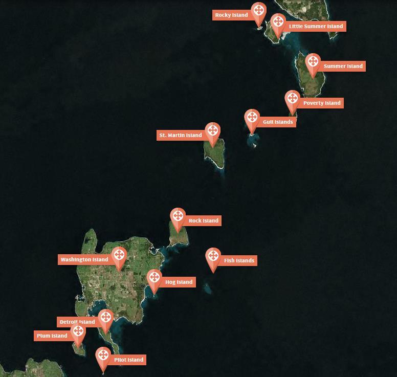

3 The Grand Traverse Islands
4 Summary The Grand Traverse Islands, stretching from Wisconsin s Door County to Upper Michigan s Garden Peninsula, are an incredible place. Encompassing 17 islands, five nineteenthcentury lighthouses, numerous Native American archeological sites, over 40 documented shipwrecks, the great estate of Chester Thordarson, and the last remaining Duluth-style US Life Saving Station on the Great Lakes, they are also home to many rare species of plants and animals and are part of the Great Arc the Niagara Escarpment spanning 650 miles from Northeast Wisconsin to Western New York. Since 1970, when the US Department of the Interior released its landmark Islands of America report, they have been considered worthy of public protection and recreational use. Yet 45 years later, after attempts made by both Wisconsin and Michigan, the island chain remains unopened, unprotected, unsung, and falling apart. This is a national tragedy. The answer is the creation of a new unit of the national park system similar to that found in the Apostle Islands. Such a park need not include any private property. Nor would it infringe upon the rights of hunters, boaters, or commercial fishermen. Additionally, it would increase tourism in a tourism-dependent region and likely be self-supporting once established.

5 This would not only help preserve historical properties, but a scenic and pristine area where citizens might walk nature trails, experience wildlife via boats, canoe and kayaks, and view those historic structures that were so very important to our maritime past. Wayne Wheeler, President US Lighthouse Society
6 Part One: The Need The Grand Traverse Islands, which bridge the gap between the Garden Peninsula in Upper Michigan and Door County in Northeast Wisconsin, are a richly bio-diverse, historically significant, and relatively undeveloped wilderness archipelago. In 1970, the US Department of the Interior recommended that they be protected and made available for recreational use in its landmark Islands of America report. And on the heels of that recommendation, Wisconsin and Michigan began jointly planning the creation of an interstate wilderness park. Wisconsin even commissioned an environmental impact study of the proposed Grand Traverse Islands State Park in 1978 and purchased five small plots of land on Detroit Island for inclusion into the park shortly thereafter. Sadly, either because of decreasing state coffers or the changing politics of the 1980s, the interstate park plan was abandoned. Decades later, the island chain remains unopened, unprotected, unsung, and falling apart. Critically important habitat for the threatened and endangered plants and animals found there is dwindling throughout the region. And some of the historic buildings located there are now among the nation s most endangered maritime structures. This is neither what the people who live here want nor what such a geologically, ecologically, and historically significant area deserves.


7 Part Two: The Answer The answer is the creation of a national park encompassing most of the chain s larger islands, in addition to sections of both mainland peninsulas. Specifically: a new unit of the national park system, open to public use, similar to that found in the Apostle Islands. Such a park need not include any private property, since a great deal of the island chain and nearby peninsulas are already owned by county, state, and federal agencies and organizations. Nor would such a park infringe upon the rights of hunters, boaters, or commercial fishermen, given that these activities occur in other national parks and lakeshores, such as the Apostle Islands.
8 We sincerely believe this project would be a certain asset to our community, as well as Michigan and Wisconsin as a whole. Along with sustaining and nurturing the immense wildlife habitat of the islands, creating a National Park would create a natural attraction which would have a positive economic impact on our area. Delta County Chamber of Commerce
, the islands consist of dolomitic limestone rock formed 420 million years ago from the compressed")
9 Part Three: The Why Even without a pressing need, the Grand Traverse Islands are worthy of national park designation. Part of the vast Niagara Escarpment (spanning 650 miles from Northeast Wisconsin to Western New York), the islands consist of dolomitic limestone rock formed 420 million years ago from the compressed sediments of a shallow, tropical sea. Rare wildflowers and orchids found almost nowhere else on earth call them home. Neotropical songbirds, bats, and butterflies return to them each and every summer. And trees believed to be over 500 years old cling to their nearly vertical, rocky bluffs. Given their name by French Voyageurs paddling canoes from one peninsula to the other, they encompass eight large islands, nine smaller islands, five nineteenth-century lighthouses, numerous Native American archeological sites, over 40 documented shipwrecks, the great estate of Chester Thordarson, and the last remaining Duluth-style US Life Saving Station on the Great Lakes. Yet there is a pressing need, and there are many reasons why a national park is the right path forward. First of all: Northern Door County, the Grand Traverse Islands, and Delta County provide critical habitat for a great number of threatened and endangered species. Regionally, the habitat for these species is shrinking day by day. By protecting the area from future development, and managing the land as a single unit, those species will stand a better chance for survival. The National Park Service would allow for this in a way
10 that the currently fragmented system of local, state, and federal agencies and organizations does not, and a set of two state parks could not. Second: the area s maritime heritage is in grave danger. Many of the most significant historical structures found throughout the Grand Traverse Islands are threatened by disrepair and collapse especially those on Pilot Island, Poverty Island, and St. Martin Island. If we don t act to save them soon, they may be lost forever. Friends groups can only do so much. And the mission of the US Fish & Wildlife Service which is currently looking at acquiring many of the islands does not include historic preservation and interpretation. Thus, the National Park Service, whose primary mission does include historic preservation and interpretation, is the perfect candidate. Third: the creation of a national park in the Grand Traverse Islands would provide for greater public access than is currently available or would be available if the area became a National Wildlife Refuge under the control of the U.S. Fish & Wildlife Service. As with all great wilderness areas, the Grand Traverse Islands have the power to help us discover ourselves and our connection to nature. They have the power to replenish our souls and help us literally re-create ourselves. But they cannot do that if public access to them is prohibited. A national park would ensure that that does not happen, and would also protect the health of the environment through the use of a backcountry permitting process. Fourth: the construction of several small docks in protected harbors throughout the Grand Traverse Islands would go a long way towards making the area a safer and more accessible place to visit. Currently, there are no public safe harbors between Rock Island and the Garden Peninsula. Given how quickly the weather can sour, it is therefore quite dangerous to visit the islands by sea kayak or sailboat if one is inexperienced yet that does not visitors from coming. The creation of a national park would allow for a
11 few small public docks to be built, thus improving public safety and accessibility. Finally: a national park would be marketable in a way that national wildlife refuges are not and the local and regional economic benefits of national parks and lakeshores are tremendous. In 2013, the entire national park system brought over $14.6 billion in spending to gateway communities! The Apostle Islands National Lakeshore alone accounted for $22.4 million of that visitor spending, supporting over 304 local jobs and the same thing would likely result from the creation of a national park in the Grand Traverse Islands. Local accommodations, restaurants, charter fishing cruises, outfitters, gas stations, grocery stores, retail shops, and countless other businesses would see a huge increase in traffic and sales volume. Countless new jobs would inevitably be created. And although these jobs would largely be directly connected to the seasonal tourism industry, proximity to a national park would make it easier to attract year-round employees in non-tourist industries.


12 The addition of a Grand Traverse Islands National Park would help our local and state economies realize incremental growth in our tourism dependent region. It would also provide another incredible opportunity for visitors to explore, experience and appreciate the incredible natural environment we are fortunate enough to call home. Door County Visitor Bureau


13 Part Four: The Proposal What might the Grand Traverse Islands National Park look like? The properties we are proposing for inclusion into the national park are first shown visually and then detailed in the pages that follow.

14 Proposed National Park Boundaries (Proposed Properties shown in green)
15 Proposed Properties Mink River State Natural Area, Door Peninsula, WI Acreage & Ownership: 1,787 acres under ownership of The Nature Conservancy. Features: Internationally recognized RAMSAR wetland, home to rare Dwarf Lake Iris & federally endangered Hine's Emerald Dragonfly. Newport State Park, Door Peninsula, WI Acreage & Ownership: 2,373 acres under state ownership. Features: Europe Lake, sand beaches w/ small dunes, critical stopover site for Monarch butterflies, maintained trails & backcountry campsites. Hotz Memorial Town Park, Door Peninsula, WI Acreage & Ownership: Approx. 1 acre under municipal ownership. Features: Sand beach & public kayak launch bordered by Newport State Park. Europe Lake Boat Launch, Door Peninsula, WI Acreage & Ownership: Approx. 1 acre under municipal ownership. Features: Public access to Europe Lake. Isle View Park, Door Peninsula, WI Acreage & Ownership: Approx. 1 acre under municipal ownership. Features: Public park & beach just south of Northport offering great view of Plum and Pilot Islands, bordered by newly forming sea caves. Garrett Bay Park, Door Peninsula, WI Acreage & Ownership: Approx. 1 acre under municipal ownership. Features: Public kayak launch on Garrett Bay, just south of Door Bluff Headlands. 50ft from Fleetwing shipwreck.
16 Proposed Properties Door Bluff Headlands County Park, Door Peninsula, WI Acreage & Ownership: 156 acres under county ownership. Features: Niagara Escarpment, Native American pictographs, beach, hiking trail, commanding view of Green Bay. Plum & Pilot Islands, Plum & Pilot Islands, WI Acreage & Ownership: 330 acres under federal ownership. Features: Niagara Escarpment, Pilot Island Lighthouse & Fog Signal Building; JE Gilmore, Forrest, & AP Nichols Shipwrecks; Plum Island Lightkeepers House, Fog Signal Building, & Range Lights; ruins of Old Plum Island Lighthouse; last remaining Duluth-style US Life Saving Station on Great Lakes; two beaches; Grapeshot shipwreck; maintained trails. Jackson Harbor Ridges State Natural Area, Washington Island, WI Acreage & Ownership: 70 acres under municipal ownership. Features: Sand dune complex near Rock Island State Park boat launch & ferry dock. Rock Island State Park, Rock Island, WI Acreage & Ownership: 912 acres under state ownership. Features: Niagara Escarpment, Thordarson Estate, small boat dock, sand beach, old fishing village site, numerous cemeteries, Native American archeological sites, the first lighthouse built on Lake Michigan, campground, maintained trails, and backcountry campsites.
17 Proposed Properties St. Martin Island (Federally-owned parcels), St. Martin Island, MI Acreage & Ownership: 1,244 acres under federal ownership Features: Niagara Escarpment, old hunting/logging cabins, old fishing village sites, small harbor on south shore with dock, access to St. Martin Island Lighthouse. Poverty Island, Poverty Island, MI Acreage & Ownership: 171 acres under federal ownership. Features: Niagara Escarpment, Poverty Island Lighthouse. Michigan State Forest Compartment 200, Summer & Little Summer Islands, MI Acreage & Ownership: 1,488 acres under state ownership. Features: Niagara Escarpment, limestone bedrock shoreline. Michigan State Forest Compartment 100, Garden Peninsula, MI Acreage & Ownership: 850 acres under state ownership. Features: Limestone bedrock shoreline. Michigan State Forest Compartment 99, Garden Peninsula, MI Acreage & Ownership: 1,158 acres under state ownership. Features: Wooded dune & swale complex, alvar ecosystem, Sucker Lake. Michigan State Forest Compartment 98, Garden Peninsula, MI Acreage & Ownership: 1,802 acres under state ownership. Features: Wooded dune & swale complex, alvar ecosystem.
18 Proposed Properties Michigan State Forest Compartment 97, Garden Peninsula, MI Acreage & Ownership: 436 acres under state ownership. Features: Limestone bedrock shoreline. Michigan State Forest Compartment 96, Garden Peninsula, MI Acreage & Ownership: 2,175 acres under state ownership. Features: Wooded dune & swale complex, ADA-accessible Portage Bay State Forest Campground, Fishery Lake, Charboneau Lake, hiking trail, and gravel boat launch. Michigan State Forest Compartment 95, Garden Peninsula, MI Acreage & Ownership: 1,662 acres under state ownership. Features: Wooded dune & swale complex, Garden Creek, Buck Fever Lake, Half Moon Lake. Sac Bay County Park, Garden Peninsula, MI Acreage & Ownership: 65 acres under county ownership. Features: Public boat launch and park. Total Acreage of Proposed Properties: 16,683
19 What Would Make It Unique? Fundamental Resources The Niagara Escarpment The Niagara Escarpment is one of the defining geological features of North America, spanning 650 miles in a wide arc across the northern Great Lakes region from Central Wisconsin through Michigan and Canada, then eastwards into New York. Formed over 420 million years ago from the compressed sediments of a shallow, tropical sea, it is an important and unique natural resource. Canada has successfully earned United Nations Biosphere Reserve recognition for its section of the escarpment and has established two national parks along its length, including Bruce Peninsula National Park and Fathom Five National Marine Park. In the United States, no federal management agency has acknowledged this incredible natural feature the most visible, accessible, and striking example of which is found in the Grand Traverse Islands. Water Resources Marking the divide between Green Bay and Lake Michigan, the Grand Traverse Island Chain is defined by water. Frozen water created glaciers during the last Ice Age that sculpted the Grand Traverse Islands out of the Niagara Escarpment. Depressions left behind by those same glaciers then filled in with water, creating Lake Michigan, Green Bay, and the shoreline of the Grand Traverse Islands that can be seen today. These great bodies of fresh water continue to sculpt the islands to this day. Moreover, the wetlands around the Grand Traverse Islands are internationally significant earning RAMSAR designation in 2014.
20 Lighthouse Landscapes The Grand Traverse Islands are home to one of the densest concentrations of lighthouses and associated structures in the United States: five lighthouses, one United States Life Saving Service station, four fog signal buildings, two separately constructed lightkeeper s houses, one set of range lights, and a number of other associated outbuildings all within a span of less than 25 miles. Pottawatomie Lighthouse on Rock Island was the first lighthouse built in Wisconsin (and northern Lake Michigan) and the U.S.L.S.S. Station on Plum Island is the last remaining Duluth-style Life Saving Service station on the Great Lakes. Threatened and Endangered Species Hine s Emerald Dragonflies (E), Dwarf Lake Iris (T), Bats (all WT, including Northern Long-Eared T), Glacial Relict Land Snails (WE, WT), Snow Trillium (WT), Lady Slipper Orchids (some WT), Artic Primrose, Canada Yew, Bald Eagles, Monarch Butterflies, and numerous species of migratory birds (in addition to a wide range of other plants and animals) call the Grand Traverse Islands home, and rely on them during their annual migrations.* Night Sky Very little light pollution exists in the Grand Traverse Islands, offering unparalleled opportunities to observe the night sky. Additionally, the island s north-south orientation, with Green Bay to the West and Lake Michigan to the East, offers many opportunities for seeing stellar, solar and lunar phenomenon including the Aurora Borealis (Northern Lights). * E Federally Endangered, T Federally Threatened, WE Wisconsin Endangered, WT Wisconsin Threatened
21 Other Important Resources Rock Island s Cultural Landscapes In 1910, all of Rock Island apart from the lighthouse was purchased by a wealthy Icelandic-American inventor and pioneer in high-voltage electrical equipment named Chester Thordarson for use as a summer estate. Thordarson had won a gold medal at the St. Louis World s Fair in 1904 for designing and building the first million-volt transformer and quickly became a prominent businessman in Chicago, considered both a friend and rival of Thomas Edison. In the 1920s, using limestone rock quarried from the island, he had expanded his estate to include a boathouse and Great Hall, several cottages, a pagoda, and a summer kitchen among other buildings and structures. Archeological Resources Numerous Native American archeological sites have been found across the Grand Traverse Islands, including pictographs and an Ottawa-Huron palisade wall from the 1600s. A great number of archeological resources from French Voyageurs and Jesuit Missionaries have also been recovered and documented. These Voyageurs and Missionaries often traveled through the area on their way to and from Central Wisconsin, and it was the Voyageurs who gave the area its name because it represented to them in their canoes a Long Crossing. Recreational Values The Grand Traverse Islands offer a wide range of recreational opportunities, including hiking, camping, birding, backpacking, boating, sailing, kayaking, canoeing, snorkeling, SCUBA diving, fishing, hunting, skiing, snowshoeing and photography.
22 Shipwrecks There are over 40 documented shipwrecks in the Wisconsin section of the Grand Traverse Islands alone three of which (the JE Gilmore, AP Nichols, & Forrest) can be found within 40ft of each other in just over 20ft of water off of Pilot Island. The Grand Traverse Islands are also the last known location of and most likely location for discovering Le Griffon, the first sailing ship built and sailed on the Great Lakes, which went missing in 1679 after leaving Rock Island. It remains missing to this day.

 of the area in question, in order to determine its significance, suitability, and feasibility.")
23 Part Five: The Process How are national parks created? One of two ways: through an Act of Congress or through an Executive Order of the President although the second method can only be applied to lands currently under federal control and would result in a national monument, rather than a national park. Before either can happen, however, the National Park Service must conduct a Special Resource Study (SRS) of the area in question, in order to determine its significance, suitability, and feasibility. The National Park Service can only conduct an SRS if it is authorized by Congress to do so and the process is as follows: Congress must pass legislation requesting the National Park Service to conduct an SRS of the proposed park. The National Park Service must return with a positive SRS. Congress must then pass legislation creating the new national park (or the President must declare the creation of a national monument).

24 Conclusion Forty-five years after they were identified for protection in the U.S. Department of the Interior s Islands of America report, the Grand Traverse Islands remain unopened, unprotected, unsung, and falling apart. This is neither what the people who live here want nor what such a geologically, ecologically, and historically rich and significant area deserves. The answer is the creation of a national park that is more open to public use similar to that found in the Apostle Islands. The reasons are many: environmental, historical, recreational, and economic. No private lands need be included. And the rights of hunters, boaters, and commercial fisherman would not be curtailed.

25 These islands, many of them very remote, are not only beautiful but important to bird migration, the eco system and tourism. Please support this effort to forever protect this national treasure. Jim Robinson, Owner Shoreline Charter Cruises

26 Contact: Friends of the Grand Traverse Islands 253 N 1 st Ave, Suite 1 Sturgeon Bay, WI info@grandtraverseislands.org
Proposal: Grand Traverse Islands National Lakeshore
 Proposal: Grand Traverse Islands National Lakeshore August 10, 2015 Contents: Summary Part 1: The Need Part 2: The Answer Part 3: The Why Part 4: The Proposal Part 5: The Process Conclusion Summary The
Appendix A BC Provincial Parks System Goals
 Appendix A BC Provincial Parks System Goals The British Columbia Provincial Parks System has two mandates: To conserve significant and representative natural and cultural resources To provide a wide variety
Niagara Natural Heritage Park
 A Future Proposal For the Niagara-on-the-Lake DND Lands....... Parks Canada Lakeshore Road Property 1 May, 2016 The Harmony Residents Group We are proposing a Natural Heritage Park be established on the
Photography Guide U.P. of Michigan
 Photography Guide U.P. of Michigan Porcupine Mountains Pictured Rocks National Seashore & Tahquamenon Falls By Bill Welch The U.P. of Michigan Michigan s Upper Peninsula (the U.P.) is a forest covered
$850,000 Awarded to 20 Organizations
 $850,000 Awarded to 20 Organizations The Conservation Alliance is pleased to fund the following organizations to support their efforts to protect wild lands and waterways for their habitat and recreation
A Publication of Friends of Sleeping Bear Dunes
 A Publication of Friends of Sleeping Bear Dunes 2014, Friends of Sleeping Bear Dunes, P.O. Box 545, Empire, MI 49630 www.friendsofsleepingbear.org info@friendsofsleepingbear.org Learn more about the Friends
THE SETTING REGION COMMUNITY ANALYSIS
 THE SETTING REGION COMMUNITY ANALYSIS REGION Historical Setting The Crane Lake waterway pre-dates the American Indians who traveled its waters for generations before it became a fur-trading route for the
ONTARIO TRAILS COUNCIL FAQ
 Trail Facts Ontario has some of the most treasured and protected outdoor areas in the world with: 329 Provincial Parks 400 Conservation Areas 292 Conservation Reserves Many people link trails with recreation
Pinellas County Environmental Lands
 Pinellas County Environmental Lands In addition to traditional parks and recreation facilities, Pinellas County owns and manages a system of environmental lands that provides specialized resource-based
Field Guide. Nature Nearby. Traverse City
 Field Guide Nature Nearby Traverse City FEATURED PROPERTIES 1 DEEPWATER POINT NATURAL AREA 2 HICKORY MEADOWS NATURAL AREA KALKASKA 3 MAPLE BAY NATURAL AREA E as t A rm G r a n d Tr a v er s e B ay 4 PELIZZARI
MAIN LAKE PROVINCIAL PARK
 MAIN LAKE PROVINCIAL PARK PURPOSE STATEMENT AND ZONING PLAN March 2003 MAIN LAKE PROVINCIAL PARK Purpose Statement and Zoning Plan Primary Role The primary role of Main Lake Park is to protect a biologically
155 acres on Tyaughton Lake 900 feet of Pristine Waterfront Private & Secluded Property
 155 acres on Tyaughton Lake 900 feet of Pristine Waterfront Private & Secluded Property 946 Tyaughton Lake Road Gold Bridge BC V0K1P0 900 ft of waterfront with 155 acres of south facing easy access. This
BROUGHTON ARCHIPELAGO PROVINCIAL PARK
 BROUGHTON ARCHIPELAGO PROVINCIAL PARK PURPOSE STATEMENT AND ZONING PLAN March 2003 BROUGHTON ARCHIPELAGO PROVINCIAL PARK Purpose Statement and Zoning Plan Primary Role The primary role is to contribute
Geoscape Toronto The Oak Ridges Moraine Activity 2 - Page 1 of 10 Information Bulletin
 About 13,000 years ago as the Laurentide Ice Sheet melted, glacial meltwater accumulated between the ice sheet and the Niagara Escarpment. This formed a lake basin into which gravel and sand were deposited.
Washakie Wilderness Ranch
 Washakie Wilderness Ranch Dubois, Wyoming Fly Fishing Hunting Ranching Conservation Washakie Wilderness Ranch Dubois, Wyoming Introduction: A stunning 160-acre parcel located at the base of the Ramshorn
National Park Service Wilderness Action Plan
 National Park Service U.S. Department of the Interior National Park Service Wilderness Action Plan National Wilderness Steering Committee National Park Service "The mountains can be reached in all seasons.
VOLUME II APPENDIX F DETAILED PHYSICAL DESCRIPTION OF PROJECT RESERVOIRS AND LANDS
 VOLUME II APPENDIX F DETAILED PHYSICAL DESCRIPTION OF PROJECT RESERVOIRS AND LANDS THE CENTRAL NEBRASKA PUBLIC POWER AND IRRIGATION DISTRICT FERC PROJECT NO. 1417 PHYSICAL DESCRIPTION OF PROJECT LANDS
MARBLE RIVER PROVINCIAL PARK
 MARBLE RIVER PROVINCIAL PARK PURPOSE STATEMENT AND ZONING PLAN March 2003 MARBLE RIVER PROVINCIAL PARK Purpose Statement and Zoning Plan Primary Role The primary role of Marble River Park is to protect
discover Genuine Montana The Last Best Place Great Falls Montana
 discover Genuine Montana The Last Best Place Great Falls Montana the grandest sight I ever beheld... 1805 Meriwether Lewis journal entry Resting on the high plains along Montana s Rocky Mountain Front
Land Use. Grasslands and Rangelands National Parks and Reserves. Thursday, October 9, 14
 Land Use Grasslands and Rangelands National Parks and Reserves MANAGING AND SUSTAINING GRASSLANDS Almost half of the world s livestock graze on natural grasslands (rangelands) and managed grasslands (pastures).
Wallace Lake Provincial Park. Management Plan
 Wallace Lake Provincial Park Management Plan 2 Wallace Lake Provincial Park Table of Contents 1. Introduction... 3 2. Park History... 3 3. Park Attributes... 4 3.1 Natural... 4 3.2 Recreational... 4 4.
THE REGION LAKE SUPERIOR THE GITCHI-GAMI TRAIL & THE NORTH SHORE
 LAKE SUPERIOR THE GITCHI-GAMI TRAIL & THE NORTH SHORE 7 LAKE SUPERIOR: Water covers 70% of the earth s surface area, but only 3% of it is freshwater. Saltwater makes up 97% of the earth s water supply.
Conservation Results In An Urban Environment Through Public-Private Partnerships
 Conservation Results In An Urban Environment Through Public-Private Partnerships James Boase, U.S. Fish and Wildlife Service Supporting Contributors John Hartig, USFWS Allison Krueger, USFWS Ed Roseman,
Clearwater Lake Provincial Park. Draft Management Plan
 Clearwater Lake Provincial Park Draft Management Plan Clearwater Lake Provincial Park Draft Management Plan Table of Contents 1. Introduction... 3 2. Park History... 4 3. Park Attributes... 4 3.1 Location/Access...4
2.0 PARK VISION AND ROLES
 2.0 PARK VISION AND ROLES 2.1 Significance in the Protected Area System Marble Range and Edge Hills provincial parks protect 6.8% of the Pavillion Ranges Ecosection, which is located in the Southern Interior
Apostle Islands National Lakeshore Visitor Study
 Social Science Program National Park Service U.S. Department of the Interior Visitor Services Project Apostle Islands National Lakeshore Visitor Study 2 Apostle Islands National Lakeshore Visitor Study
Access: The rocky shoreline is only accessible via private property.
 10. Whale Cove Site description: Whale Cove is a small cove fringed by private homes and condominiums with diverse and relatively undisturbed rocky intertidal and subtidal habitat located approximately
Wallace Lake Provincial Park. Draft Management Plan
 Wallace Lake Provincial Park Draft Management Plan Wallace Lake Provincial Park Draft Management Plan Table of Contents 1. Introduction... 3 2. Park History... 3 3. Park Attributes... 4 3.1 Natural...
CONGRESSIONAL RECORD -- SENATE. Wednesday, June 18, th Congress, 1st Session. 143 Cong Rec S 5927
 CONGRESSIONAL RECORD -- SENATE Wednesday, June 18, 1997 105th Congress, 1st Session 143 Cong Rec S 5927 REFERENCE: Vol. 143, No. 85 TITLE: STATEMENTS ON INTRODUCED BILLS AND JOINT RESOLUTIONS SPEAKER:
1/08/2008 DRAFT FOR REVIEW ONLY Note: Not yet edited by DCPD.
 APPENDIX - DOOR COUNTY PARKS Bailey s Harbor Ridges Park is a 30-acre park that provides scenic hiking trails through the Bailey s Harbor Wildlife Sanctuary. The park is also home to two rangelight houses
Proposal to Redevelop Lower Kananaskis River-Barrier Lake. Bow Valley Provincial Park
 Frequently Asked Questions Proposal to Redevelop Lower Kananaskis River-Barrier Lake Bow Valley Provincial Park Frequently Asked Questions What has been decided? What are the details of the plan? What
VARGAS ISLAND PROVINCIAL PARK
 VARGAS ISLAND PROVINCIAL PARK PURPOSE STATEMENT AND ZONING PLAN February 2003 VARGAS ISLAND PROVINCIAL PARK Purpose Statement and Zoning Plan Primary Role The primary role of Vargas Island Park is to protect
Dusty Boots Unit II. Available Parcels and Informational Summary
 Dusty Boots Unit II Available Parcels and Informational Summary January 2008 Notice to Recipients Other Properties May be available upon Request. Please feel free to contact us with other requests as this
MULTI SPORT ADVENTURE
 MULTI SPORT ADVENTURE This trip is designed for the active explorer. Discover Alaska through outdoor activities, ranging from serene to heart-pounding! Kayak between glaciers, fish for wild salmon, and
The Superior Venture
 All-American Adventures The Superior Venture Explore the parks of Wisconsin, Michigan s upper peninsula, and Lake Superior s largest island Content was created by AAA in collaboration with the National
Narrows West Lots For Sale Overview
 Lots For Sale Overview Dear Valued Customer, Owning a cottage property is a dream that many people share. is working diligently to create a new cottage development and resort community at Lake Manitoba
SECTION ONE. Scotland s National Parks and National Nature Reserves Ten Things You Might Not Know
 SECTION ONE Scotland s National Parks and National Nature Reserves Ten Things You Might Not Know 5 Ten Things You Might Not Know... 1. SCOTLAND S NATIONAL PARKS AND NATIONAL NATURE RESERVES ARE BEAUTIFUL,
Our Cross Country Expedition (Part II)
") Our Cross Country Expedition (Part II) Day 1 (9/1/2012): Our first stop after leaving Boston was to visit the marvelous Flume Gorge of Franconia Notch State Park near Lincoln, New Hampshire. While there,
Our Cross Country Expedition (Part II) Day 1 (9/1/2012): Our first stop after leaving Boston was to visit the marvelous Flume Gorge of Franconia Notch State Park near Lincoln, New Hampshire. While there,
THOMAS A. SWIFT METROPARK Introductions History Present Conditions Future Development Plans Implementation Strategies Statistics
 THOMAS A. SWIFT METROPARK Introductions History Present Conditions Future Development Plans Implementation Strategies Statistics Introduction As an open meadow park positioned along the Mahoning River,
Recreation. Individuals Communities Economy Environment
 Recreation There s a Corps Lake Near You! Value to Individuals When it s time for outdoor recreation, Americans head for the water. Our many lakes, rivers, and beaches offer everyone fun, fitness, rest,
4.0 OUTDOOR RECREATION 4.1 PUBLIC LANDS
 4.0 OUTDOOR RECREATION 4.1 PUBLIC LANDS Public lands provide a wide range of recreational opportunities and are considered a valuable community asset. There may be seasonal and/or other use restrictions
North Woods Wilderness Canoe Adventure
 Canoeing Portaging Fishing Live Wolf Study Photography Exploration TLS Voyages North Woods Wilderness Canoe Adventure Boundary Waters, Minnesota e 22- July 6, 2015 Offered this summer through TLS Voyages
AMERICAN S PARTICIPATION IN OUTDOOR RECREATION: Results From NSRE 2000 (With weighted data) (Round 1)
 (Round 1)") AMERICAN S PARTICIPATION IN OUTDOOR RECREATION: Results From NSRE 2000 (With weighted data) (Round 1) The emphasis of this report is on participation patterns across activities and segments of our society.
AMERICAN S PARTICIPATION IN OUTDOOR RECREATION: Results From NSRE 2000 (With weighted data) (Round 1) The emphasis of this report is on participation patterns across activities and segments of our society.
Ouimet Canyon Provincial Nature Reserve. Management Plan
 Ouimet Canyon Provincial Nature Reserve Management Plan NOTE: This document has been scanned and formatted, and therefore is slightly different from the original version. -March 2002 Additional copies
Outdoor Activities. Wisconsin Timber Rattlers Game
 Outdoor Activities Note some of these items are coupled with camping to make these outdoor items. Note Some items appear more than once in different groupings. Note: Some items may be specific to a city,
Recreation in the Battle River Basin: Overview. John Thompson, Watrecon Consulting
 Recreation in the Battle River Basin: Overview John Thompson, Watrecon Consulting Recreation Rates for Alberta & Battle Basin Households 1996 2004 Battle Basin Alberta Battle Basin Alberta Bird Watching
Eastern Canada Explorer Highlights - 16 days, 35 hrs, 3400 nm
 Eastern Canada Explorer Highlights - 16 days, 35 hrs, 3400 nm This tour brings you many Canadian icons: Niagara Falls, the lakes and forests of the Canadian Shield, and the UNESCO site of Old Quebec City,
Lecture 08, 22 Sep 2003 Role Playing. Conservation Biology ECOL 406R/506R University of Arizona Fall Kevin Bonine
 Lecture 08, 22 Sep 2003 Role Playing Conservation Biology ECOL 406R/506R University of Arizona Fall 2003 Kevin Bonine 1. Role Playing Exercise 2. Exam Wed -group portion outside - ~40 minutes individual,
13.1 REGIONAL TOURISM ISSUES AND SUMMARY OF FINDINGS
 13 REGIONAL TOURISM T he County of Mariposa s recreation needs and facilities fall within two categories: regional tourism and local recreation. This Element focuses on regional tourism issues related
Map 1.1 Wenatchee Watershed Land Ownership
 Map 1.1 Wenatchee Watershed Land Ownership Map 1.1 Wenatchee Watershed Land Ownership The Wenatchee watershed lies in the heart of Washington state in Chelan County. Just larger than the state of Rhode
PROUDLY BRINGING YOU CANADA AT ITS BEST. Management Planning Program NEWSLETTER #1 OCTOBER, 2000
 PROUDLY BRINGING YOU CANADA AT ITS BEST VUNTUT NATIONAL PARK Management Planning Program NEWSLETTER #1 OCTOBER, 2000 INTRODUCTION This newsletter launches the development of the first management plan for
Kermadec. Ocean Sanctuary
 Kermadec Ocean Sanctuary Kermadec Ocean Sanctuary, New Zealand Pacific Remote Islands National Marine Monument, United States Coral Sea Marine Reserve, Australia Proposed Pitcairn Marine Reserve, United
Proposal for Thai IX 2010 Peace Corps Reunion
 Proposal for Thai IX 2010 Peace Corps Reunion Introduction We propose that we meet in September or early October, 2010, in Acadia National Park on Mt. Desert, Maine. The park is a magnificent setting,
Montana Island Lodge 2433 Highway 83 Seeley Lake, Montana
 Island Lodge 2433 Highway 83, INTRODUCTION Built on an island in the middle of a picturesque mountain lake, the Island Lodge is a once-in-a-lifetime estate property. Surrounded by the tranquil waters of
APPENDIX. Alberta Land Stewardship Act AMENDMENTS TO THE SOUTH SASKATCHEWAN REGIONAL PLAN
 APPENDIX Alberta Land Stewardship Act AMENDMENTS TO THE SOUTH SASKATCHEWAN REGIONAL PLAN 1 All references to Alberta Environment and Sustainable Resource Development, Environment and Sustainable Resource
National Wilderness Steering Committee
 National Wilderness Steering Committee Guidance White Paper Number 1 Issue: Cultural Resources and Wilderness Date: November 30, 2002 Introduction to the Issue Two of the purposes of the National Wilderness
MAJESTIC HIGHLANDS OF ASHEVILLE
 MAJESTIC HIGHLANDS OF ASHEVILLE Asheville s Premier, High-Elevation, Mountain-Top Property 795 ± Acres Buncombe County Western North Carolina SEALED BID AUCTION Followed by a live auction on June 21st
INFORMATION NOTICE 15-2 Limited & Excluded Lands
 INFORMATION NOTICE 15-2 Limited & Excluded Lands Schedule 1 (Land Description) of onshore petroleum Agreements issued by the Department of Energy details the total hectares calculated. Total hectares are
Immersion. Program. at Luther. Orientation Adventure-style
 Immersion at Luther Program Orientation Adventure-style Begin your college experience with new relationships, renewed confidence, and adventure! Immerse. Engage in new friendships Immersion trips are weeklong
Bankhead Lake TWO PARCELS AND 1 LOT FOR SALE
 OVERVIEW NORTH PARCEL ACRES: 46 WATERFRONT: 1,227 Front Feet PRICE: $350,000 PER ACRE: $7574 PER FRONT FT. $285 SOUTH PARCEL ACRES: 22 WATERFRONT: 1,381 Front Feet PRICE: $295,000 PER ACRE: $13,170 PER
Sasagiu Rapids Provincial Park. Draft Management Plan
 Sasagiu Rapids Provincial Park Draft Management Plan 2 Sasagiu Rapids Provincial Park Table of Contents 1. Introduction... 3 2. Background and Park Attributes... 3 2.1 Park History.... 3 2.2 Natural Features...
Lake Acreage Mcleese Lake, BC
 Lake Acreage Mcleese Lake, BC Jason Zroback jason@landquest.com 1 (604) 414-5577 Jamie Zroback jamie@landquest.com 1 (604) 483-1605 The Source for Oceanfront, Lakefront, Islands, Ranches, Resorts & Land
The View at Bankhead Lake 12 miles off new Interstate Corridor X
 The View at Bankhead Lake 12 miles off new Interstate Corridor X offers the opportunity to the first to view 6 beautiful waterfront lots on Bankhead Lake to be released Saturday August 25th. Appointment
Join the June festivities!
 Facebook Twitter Website YouTube Stephanie Nikita, Editor. June 2016 Volume 16, Issue 13 Join the June festivities! Aside from the fabulous free hike schedule the Giant's Rib has up and running for the
Cat Island Chain Background & Access Guide
 Cat Chain Background & Access Guide Brown County Port & Resource Recovery Department 2561 S. Broadway, Green Bay, WI 54304 (920) 492-4950 www.portofgreenbay.com January 2018 1 Restoration of the Cat Chain
TRAILS WHERE TO FIND TRAILS IN NOVA SCOTIA
 TRAILs SIGNAGE Know the Signs............................ 44 WHERE YOU CAN RIDE Roads and Highways........................ 46 Designated Trails........................... 47 Established Trails...........................
KOOTENAY LAKE PROVINCIAL PARK (MIDGE CREEK SITE)
") KOOTENAY LAKE PROVINCIAL PARK (MIDGE CREEK SITE) PURPOSE STATEMENT AND ZONING PLAN February 2003 Approved by: KOOTENAY LAKE PROVINCIAL PARK (Midge Creek Site) Purpose Statement and Zoning Plan Primary
KOOTENAY LAKE PROVINCIAL PARK (MIDGE CREEK SITE) PURPOSE STATEMENT AND ZONING PLAN February 2003 Approved by: KOOTENAY LAKE PROVINCIAL PARK (Midge Creek Site) Purpose Statement and Zoning Plan Primary
Camping (Primitive) Camping (RV) Electrical Potable Water Grill Established Fire Pit Picnic Table
 Camping (RV) Electrical Potable Water Grill Established Fire Pit Picnic Table") Alden - 9th Road River Mile 777 Map: 38.20833, -98.32031 Managing Agency: Kansas Department of Wildlife, Parks & Tourism Nearest Community: Alden, Rice County Kansas Developed Amenities Provided Parking
Alden - 9th Road River Mile 777 Map: 38.20833, -98.32031 Managing Agency: Kansas Department of Wildlife, Parks & Tourism Nearest Community: Alden, Rice County Kansas Developed Amenities Provided Parking
Parks & Recreation Areas Program
 PARKS & RECREATION Parks & Recreation Areas Program As part of its mission to conserve and protect natural resources, the Upper Big Blue Natural Resources District (NRD) has been involved in several large-scale
WILDLIFE BIOLOGY. Monday 20 Feb 2017
 WILDLIFE BIOLOGY Monday 20 Feb 2017 President s Day Holiday. No School WILDLIFE BIOLOGY Tuesday 21 Feb 2017 Entry Task What are the two government departments in charge of only one wildlife agency? Department
STORNETTA BROTHERS COASTAL RANCH
 STORNETTA BROTHERS COASTAL RANCH Location: Surrounding Point Arena Lighthouse and immediately south of Manchester State Park Mendocino Co., CA Acres: 1,860 Resources: Over two miles of Pacific Ocean coastline
The Jaguar Challenge Tour
 The Jaguar Challenge Tour Visit the cloud forest & enjoy the Pacific Islands of Panama Traveling with us will be much more than taking only pictures and leaving only footprints; it s an opportunity for
TOWARDS SUSTAINABLE MANAGEMENT OF MARINE AND COASTAL HABITATS ASIA- PACIFIC DAY FOR THE OCEAN
 TOWARDS SUSTAINABLE MANAGEMENT OF MARINE AND COASTAL HABITATS WANNAKIAT THUBTHIMSANG PHUKET MARINE BIOLOGICAL CENTER, DMCR, THAILAND ASIA- PACIFIC DAY FOR THE OCEAN 20 NOVEMBER 2018, CONFERENCE ROOM 4,
INFORMATIONAL PACKET GATHER NETWORK LEARN PLAY
 INFORMATIONAL PACKET GATHER NETWORK LEARN PLAY For more information about the annual meeting visit alaskacreditunions.org What to know about Homer Welcome to Homer, Alaska, on stunning Kachemak Bay! Made
Mission 60% Figure 1: API Criteria Relative to Each Other
 Asset Priority Index Criteria The Asset Priority Index (API) The API is a balanced scorecard approach that allows park managers and decisionmakers to compare the relative importance of facilities in relation
Coastal Dune Locations of Ontario
 Coastal Dune Protection along Ontario s Great Lakes Coast Great Lakes Dune Conference, Traverse City, Michigan Oct 3 4, 2006 J. Childs, WLU Dunes in Ontario Coastal very small % of coastline Located: At
Hudson Bay Lowlands Proposed Protected Areas
 Hudson Bay Lowlands Proposed Protected Areas Hudson Bay Lowlands Proposed Protected Areas The Protected Areas Initiative has identified portions of the Hudson Bay Lowlands region that have significant
Mills Pecos River Ranch 7800 Acres Val Verde County, Texas Situated along both sides of the Pecos River
 Mills Pecos River Ranch 7800 Acres Val Verde County, Texas Situated along both sides of the Pecos River James King, Agent Office 432-426-2024 Cell 432-386-2821 James@KingLandWater.com King Land & Water
(Short Listing) DUPUYER ACREAGE, ROCKY MOUNTAN FRONT
 DUPUYER ACREAGE, ROCKY MOUNTAN FRONT") (Short Listing) DUPUYER ACREAGE, ROCKY MOUNTAN FRONT This unique property is located 8½ miles northwest of Dupuyer, Montana and approximately thirty 30 miles northwest of Choteau, Montana. Great Falls
(Short Listing) DUPUYER ACREAGE, ROCKY MOUNTAN FRONT This unique property is located 8½ miles northwest of Dupuyer, Montana and approximately thirty 30 miles northwest of Choteau, Montana. Great Falls
TRANSBOUNDARY ASSESSMENT NP PLITVICE LAKES / NP UNA
 Ognjen Škunca & Željka Rajković consultants TRANSBOUNDARY ASSESSMENT NP PLITVICE LAKES / NP UNA 3 2 1 The studied TB region natural historical border between Croatian and B&H in the study area defined
Proposal to Redevelop Lower Kananaskis River-Barrier Lake. Bow Valley Provincial Park. Frequently Asked Questions
 Proposal to Redevelop Lower Kananaskis River-Barrier Lake Bow Valley Provincial Park Frequently Asked Questions What is being proposed? What are the details of the proposal? Where is the project area located?
Whitemouth Falls Provincial Park. Draft Management Plan
 Whitemouth Falls Provincial Park Draft Management Plan Whitemouth Falls Provincial Park Draft Management Plan Table of Contents 1. Introduction... 3 2. Park History... 3 3. Park Attributes... 4 3.1 Natural...
Wildlife Tour (10 Days)
") Multi-Sport Camping Adventures Small Groups (10 max) Great Guides Top of the line Equipment Excellent Meals Active Experiences Wildlife Tour (10 Days) For those with wildlife viewing as a primary objective
Multi-Sport Camping Adventures Small Groups (10 max) Great Guides Top of the line Equipment Excellent Meals Active Experiences Wildlife Tour (10 Days) For those with wildlife viewing as a primary objective
Overnight Guided Walks
 Overnight Guided Walks Day One Climb through a forest of snow gums from Dead Horse Gap, before following the ridge line toward Mount Kosciuszko. Head for our base camp and enjoy the hospitality of our
The Frank Church River of No Return Wilderness
 ALLIANCE FOR WILDERNESS EDUCATION AND STEWARDSHIP PO Box 2667, Bellingham, WA 98227-2667 Tele: 360-927-1804 Fax: 360-527-9679 bradt@wildernessalliance.org www.wildernessalliance.org STEWARDS OF AMERICA
Massanutten Mountain Cluster
 Massanutten Mountain Cluster Signal Knob Catback Mountain Southern Massanutten Mountain Five areas of almost 49,000 acres on the Lee Ranger District compose the Massanutten Mountain Cluster of Mountain
Vermont Cows by Peter Salmon
 Vermont Cows by Peter Salmon SUSTAINABLE FOREST & PROPERTY MANAGEMENT: At current the Dorset Town Forest includes the 30 acre parcel that sits atop Owl s Head peak in Dorset. By acquiring this property
Swan Valley Farms. 523 acres for sale in Bonneville County, ID JIMMY ROUMANIS. JOHN STARR
 Swan Valley Farms JOHN STARR 208 472 2838 john.starr@colliers.com 523 acres for sale in Bonneville County, ID JIMMY ROUMANIS 208 472 2840 jimmy.roumanis@colliers.com Swan Valley Farms- 523 acres for sale
Forms of Natural Protection in Greece
 Forms of Natural Protection in Greece 105 th Primary School of Thessaloniki NATIONAL PARKS AND PROTECTED AREAS The irregular and constantly increasing human intervention in nature and the relentless exploitation
Whitefish Range Partnership Tentatively Approved by WRP 11/18/2013!Rec. Wilderness Page 1
 Whitefish Range Partnership Tentatively Approved by WRP 11/18/2013!Rec. Wilderness Page 1 Recommended Wilderness Background The Whitefish Range has a long management and legislative history associated
Buck Island Reef National Monument News Release Date: Immediate Contact: Joel Tutein, Superintendent, x 222
 National Park Service U.S. Department of the Interior www.nps.gov 2100 Church Street, # 100 Christiansted, VI 00820 News Release Date: Immediate Contact: Joel Tutein, Superintendent, Joel.Tutein@nps.gov
LIST OF LOCAL SIGHTS AND RECREATION
 LIST OF LOCAL SIGHTS AND RECREATION Pictures of Klamath Falls - http://members.spree.com/sip/sunnidaze/me/kfalls.html One of the local members of Kingsley Field took some pictures of the local area in
Preferred Recreation Recommendations Stemilt-Squilchuck Recreation Plan March 2018
 Preferred Recreation Recommendations Stemilt-Squilchuck Recreation Plan March 2018 Below are the recommended recreation ideas and strategies that package together the various recreation concepts compiled
Marchand Provincial Park. Management Plan
 Marchand Provincial Park Management Plan 2 Marchand Provincial Park Table of Contents 1. Introduction... 3 2. Park History... 3 3. Park Attributes... 4 3.1 Natural... 4 3.2 Recreational... 4 3.3 Additional
2.1 Physical and Biological Description Matabitchuan River Watershed
 2.1 Physical and Biological Description Watershed 2.1.1 Physical Description The system watershed has a total area of about 933 km 2 and is a tributary system to Lake Temiskaming and the Ottawa River Drainage
GUIDE TO SCOUTING. at Miami Dade County Park & Recreation NATURE CENTERS
 GUIDE TO SCOUTING at Miami Dade County Park & Recreation NATURE CENTERS GUIDE TO SCOUTING Dear Boy and Girl Scout Leaders, Scouting has long been known to be a rewarding and valuable part of many people
Sunrise Ranch 6890 acres, Jeff Davis County, Texas On the Fort Davis Scenic Loop
 Sunrise Ranch 6890 acres, Jeff Davis County, Texas On the Fort Davis Scenic Loop 432-386-2821 Cell 432-426-2024 Office james@kinglandwater.com King Land & Water LLC P.O. Box 109, 600 State Street, Fort
Acquisition in fee simple of approximately one-half acre of property on the shore of Spring Lake to expand the Lakeside Beach Park.
 Lakeside Beach TF00-136 $122,550.00 in fee simple of approximately one-half acre of property on the shore of Spring Lake to exp the Lakeside Beach. 2000 River Ravines TF00-150 $910,000.00 in fee simple
Birch Point Provincial Park. Management Plan
 Birch Point Provincial Park Management Plan 2 Birch Point Provincial Park Table of Contents 1. Introduction... 3 2. Park History... 3 3. Park Attributes... 4 3.1 Natural... 4 3.2 Recreational... 4 4. Park
Courtesy of Wayde Carroll/Alaska Wildland Adventures. Alaska
 Courtesy of Wayde Carroll/Alaska Wildland Adventures Alaska A SPECIAL CONSERVANCY DEPARTURE AUGUST 28 - SEPTEMBER 4, 2016 Join us and fellow supporters on this excursion to Alaska. Spend time with us during