Photography Guide U.P. of Michigan
|
|
|
- Allyson Burke
- 5 years ago
- Views:
Transcription
1 Photography Guide U.P. of Michigan Porcupine Mountains Pictured Rocks National Seashore & Tahquamenon Falls By Bill Welch
2 The U.P. of Michigan Michigan s Upper Peninsula (the U.P.) is a forest covered wilderness almost surrounded by Lakes Superior, Huron & Michigan. The Peninsula is only connected to land via a remote section of Wisconsin, and the only connection to the rest of Michigan is via the 5 mile long Mackinac Bridge. The U.P. is greater in size than the combined states of Connecticut, Delaware, Massachusetts and Rhode Island. The U.P. stretches 384 miles across its width and 233 miles from Menominee (to the south) and Copper Harbor at the tip of the Keweenaw Peninsula.
3 Fall in the U.P. Over 50 varieties of trees grow in the U.P. but the maple, birch and aspen turn the landscape into a tapestry of red, gold, orange and yellow. These bright colors are usually offset by the evergreens of pine, spruce, hemlock and balsam. The U.P. has over 150 waterfalls and over 4,000 clear blue lakes. The best time to visit the U.P. for the best fall color is from mid-september to mid-october, with the peak usually being the last week of September through the first week of October.
4 Where to Go Beautiful fall color can be found throughout the U.P. The top 3 locations. Porcupine Mountains. Pictured Rocks National Seashore. Tahquamenon Falls
5 Fall in the U.P. Over 50 varieties of trees grow in the U.P. but the maple, birch and aspen turn the landscape into a tapestry of red, gold, orange and yellow. These bright colors are usually offset by the evergreens of pine, spruce, hemlock and balsam. The U.P. has over 150 waterfalls and over 4,000 clear blue lakes. The best time to visit the U.P. for the best fall color is from mid-september to mid-october, with the peak usually being the last week of September through the first week of October.
6 Porcupine Mountains (the Porkies) 58,000 acres of rivers, waterfalls, gorges and lakes along the shore of Lake Superior. Largest virgin stands of pine and hemlock in the world! Largest wilderness area between the Appalachian and Rocky Mountains. The best time to visit the U.P. for the best fall color is from mid-september to mid-october, with the peak usually being the last week of September through the first week of October.

7 Porcupine Mountains
8 Pictured Rocks National Seashore Sandstone cliffs of ochre, tan, & brown sandwiched with layers of white and green, towering to 200 feet above Lake Superior. The first national seashore authorized in 1966 to preserve the shoreline, cliffs, beaches and dunes. Pictured Rocks refers to streaks of minerals that stain and decorate the face of the sculptured cliffs.
9 Pictured Rocks National Seashore and the Surrounding Areas Variety of photographic opportunities including a lighthouse, sand dunes and the Sable Waterfall. Most people photograph the seashore itself with the cold blue-green waters of Lake Superior in the image. One of the best ways to photograph Pictured Rocks is from the water. From September 1 through October 10 there are 2 boat rides daily. The boat rides last about 3 hours and take you as far as Chapel rock. The boat maneuvers close to the cliffs for excellent views. The surrounding area also offers excellent opportunities to photograph the fall foliage, reeds in the water and ponds along the side roads.

10 Pictured Rocks National Seashore
11 Tahquamenon Falls The major attraction here is the Tahquamenon Falls.. The Upper Tahquamenon Falls is the second largest waterfall west of the Mississippi. The Lower Tahquamenon Falls is a series of falls and cascades. At the Tahquamenon Falls parking lot there is a paved walk that takes you to 2 views that provides excellent fall color to accent the rust waters of the Tahquamenon Falls.
12 Tahquamenon Falls
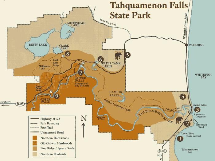
13 Tahquamenon Falls

14 1 Isle Royale National Park 2 Porcupine Mountains State Park 3 Black River Recreation Area 4 Gogebic Ridge Hiking Trail 5 Presque Isle Flowage 6 Clark Lake Day-Use Area 7 Bat Mine 8 Deer Marsh Interpretive Trail 9 Watersmeet Rails to Trails 10 Davidson Lakes 11 Bob Lake Campground 12 Silver Mountain 13 Keweenaw Peninsula 14 Sturgeon River Sloughs 15 Canyon Falls Roadside Park 16 Groveland 17 Moose Country 18 Wetmore Pond 19 Presque Isle Park 20 Gene's Pond 21 Hardwood Impoundment 22 Menominee River/Piers Gorge 23 Peninsula Point 24 Portage Marsh 25 Boney Falls Basin 26 Au Train Songbird Trail 27 Sand Point Marsh Trail/Pictured Rocks National Lakeshore 28 Rainey Wildlife Area 29 Seney National Wildlife Refuge 30 Big Knob Forest Campground 31 Cut River Bridge 32 Tahquamenon Falls State Park 33 Whitefish Point Bird Observatory 34 Monocle Lake Trail 35 Munuscong Wildlife Mgmt Area 36 Horseshoe Bay
Day 1 History & Wildlife
 Welcome to our 3 Day Newberry, MI Itinerary brought to you by America s Best Value Inn Tahquamenon Country of Newberry. Day 1 History & Wildlife The Luce County Historical Museum Drive time: 5 minutes
The Superior Venture
 All-American Adventures The Superior Venture Explore the parks of Wisconsin, Michigan s upper peninsula, and Lake Superior s largest island Content was created by AAA in collaboration with the National
Photographing Upper Peninsula Waterfalls
 Photographing Upper Peninsula Waterfalls Tod Poirier Freelance Photographer Photography is one of my passions. The following spread showcases several Upper Peninsula waterfalls. At times a single drop
THE REGION LAKE SUPERIOR THE GITCHI-GAMI TRAIL & THE NORTH SHORE
 LAKE SUPERIOR THE GITCHI-GAMI TRAIL & THE NORTH SHORE 7 LAKE SUPERIOR: Water covers 70% of the earth s surface area, but only 3% of it is freshwater. Saltwater makes up 97% of the earth s water supply.
APPENDIX 19-II. Ontario Trail Network Trailheads EAST-WEST TIE TRANSMISSION PROJECT AMENDED ENVIRONMENTAL ASSESSMENT REPORT
 EAST-WEST TIE TRANSMISSION PROJECT AMENDED ENVIRONMENTAL ASSESSMENT REPORT APPENDIX 19-II Ontario Network heads Report. 1536607/2000/2219 Ontario Network heads in the n-commercial Land and Resource Use
Day 1 History & Wildlife
 Welcome to our 3 Day Newberry, MI Itinerary brought to you by America s Best Value Inn Tahquamenon Country of Newberry. Day 1 History & Wildlife The Luce County Historical Museum Drive time: 5 minutes
ACCESS INVENTORY AND IMPROVEMENT PLAN
 ACCESS INVENTOR AND IMPROVEMENT PLAN Prepared by: Western Upper Peninsula Planning & Development Region Financial Assistance for the project was provided, in part, by the Michigan Coastal Management Program,
To Wellness. To Wellness PASSPORT PASSPORT. Partners. Partners. Ashland County Health & Human Services 630 Sanborn Avenue, Ashland, WI
 Partners Ashland County Health & Human Services 630 Sanborn Avenue, Ashland, WI Ashland Bretting Center 320 4th Avenue W., Ashland, WI PASSPORT Bayfield County Health Department 117 E. 6th Street, Washburn,
TRAVERSING THE U.P. A plethora of options makes Michigan s Upper Peninsula an RVers heaven. ROUTE 66 Road Trip. By Mark Moore
 ROUTE 66 Road Trip By Mark Moore TRAVERSING THE U.P. A plethora of options makes Michigan s Upper Peninsula an RVers heaven 24 It s easy to get lost in the vastness of Michigan s Upper Peninsula. Stretching
canterburyrv.com A vacation lasts for one week. A new way of living lasts forever.
 canterburyrv.com A vacation lasts for one week. A new way of living lasts forever. Sometimes you have to stop worrying about where you want to go in life, and start thinking about where you want to go
Split Rock 100th anniversary. Superior Point Light. Eagle Harbor Lighthouse. Marquette Harbor Lightouse. Grand Island Lighthouse(before)
") Split Rock 100th anniversary Split Rock Lighthouse Duluth Entry Lights Superior Point Light Two Harbors Lighthouse Eagle Harbor Lighthouse History Eagle Harbor Lighthouse Eagle Harbor Lighthouse 2 Ontonagon
Split Rock 100th anniversary Split Rock Lighthouse Duluth Entry Lights Superior Point Light Two Harbors Lighthouse Eagle Harbor Lighthouse History Eagle Harbor Lighthouse Eagle Harbor Lighthouse 2 Ontonagon
Our Cross Country Expedition (Part II)
") Our Cross Country Expedition (Part II) Day 1 (9/1/2012): Our first stop after leaving Boston was to visit the marvelous Flume Gorge of Franconia Notch State Park near Lincoln, New Hampshire. While there,
Our Cross Country Expedition (Part II) Day 1 (9/1/2012): Our first stop after leaving Boston was to visit the marvelous Flume Gorge of Franconia Notch State Park near Lincoln, New Hampshire. While there,
Physical Regions of the U.S.
 Physical Regions of the U.S. Quickly use this map to label the map on your paper Pacific Coast The coast from southern California to Alaska The region of the Pacific Northwest has a long history that was
15 Scenic Cities of the Rust Belt
 15 Scenic Cities of the Rust Belt 2 April 2012 www.rustwire.com No one can deny the awe-inspiring scenic beauty of Seattle, San Francisco, San Diego, or Salt Lake City. But, often overlooked are the splendid
Great Lakes Navigation System Buffalo District
 Great Lakes Navigation System Buffalo District Josh Feldmann U.S. Army Corps of Engineers Chief, Operations Branch 4 FEB 2014 US Army Corps of Engineers Key FY14 Buffalo District O&M Dredging Activities
Great Lakes Navigation Stakeholder Meeting Shallow Draft Harbor Needs & Issues
 Great Lakes Navigation Stakeholder Meeting Shallow Draft Harbor Needs & Issues Mike O Bryan U.S. Army Corps of Engineers Great Lakes Navigation Business Line Manager March 11, 2015 US Army Corps of Engineers
Cuyahoga Valley National Park Ohio
 Cuyahoga Valley National Park Ohio Brandywine Falls The Ledges The Beaver Marsh Temperate Deciduous Forest How To Get There... Located between Cleveland & Akron, Ohio Cuyahoga Valley National Park can
Proposal: Grand Traverse Islands National Lakeshore
 Proposal: Grand Traverse Islands National Lakeshore August 10, 2015 Contents: Summary Part 1: The Need Part 2: The Answer Part 3: The Why Part 4: The Proposal Part 5: The Process Conclusion Summary The
Great Lakes Navigation Stakeholder Meeting Shallow Draft Harbor Needs & Issues
 Great Lakes Navigation Stakeholder Meeting Shallow Draft Harbor Needs & Issues Mike O Bryan U.S. Army Corps of Engineers Great Lakes Navigation Business Line Manager March 17, 2014 US Army Corps of Engineers
COLORADO TRAIN ADVENTURE
 COLORADO TRAIN ADVENTURE by Melody Hagerman at Travel the Horizon Summary Traveling by rail in Colorado is the most spectacular way to take in its unique scenery. From high above the tracks, you'll enjoy
Great Lakes Navigation System Dredging Update
 Great Lakes Navigation System Dredging Update Marie Strum U.S. Army Corps of Engineers Great Lakes Navigation Team June 3, 2015 US Army Corps of Engineers Great Lakes Dredging Team Annual Meeting Great
Great Lakes Navigation System Buffalo District
 Great Lakes Navigation System Buffalo District Josh Feldmann U.S. Army Corps of Engineers Chief, Operations Branch Feb 12, 2013 US Army Corps of Engineers Key FY13 Buffalo District O&M Activities i i Dredging
NATIONAL PARK SERVICE. REMAINING SHORELINE OPPORTUNITIES in Minnesota, Wisconsin, Illinois, Indiana, Ohio, Michigan, Pennsylvania, New York
 NATIONAL PARK SERVICE Great Lakes Shoreline Recreation Area Survey REMAINING SHORELINE OPPORTUNITIES in Minnesota, Wisconsin, Illinois, Indiana, Ohio, Michigan, Pennsylvania, New York A Report Prepared
Great Lakes Navigation System
 Great Lakes Navigation System Marie Strum Great Lakes Navigation Team Great Lakes Dredging Team Meeting May 19, 2011 US Army Corps of Engineers Federal Harbors on the Great Lakes Grand Marais Beaver Bay
APPENDIX F: Trail Maps Available on the Internet
 APPENDIX F: Trail Maps Available on the Internet There are over 25 trail maps highlighting more than 150 trails within the NCHA region featured on the internet. A list of these websites are provided below:
KEWEENAW COUNTY ROADS WITH SEASONAL RESTRICTIONS
 KEWEENAW COUNTY ROADS WITH SEASONAL RESTRICTIONS ALLOUEZ TOWNSHIP PRIMARY ROADS WITH SEASONAL RESTRICTIONS 1ST STREET US 41 AHMEEK NUMBER SIX RD. 0.56 AHMEEK ST. NUMBER SIX RD. COUNTY LINE 0.39 BUMBLETOWN
NAPOWAN ADVENTURE BASE High Adventure Program
 NAPOWAN ADVENTURE BASE High Adventure Program This copy belongs to: Troop: 1 Council High Adventure Contacts Assistant Scout Executive- Randall Toland, 600 N. Wheeling Rd., Mt Prospect, IL 60056 (W) 847-824-6859
Recreation in the Battle River Basin: Overview. John Thompson, Watrecon Consulting
 Recreation in the Battle River Basin: Overview John Thompson, Watrecon Consulting Recreation Rates for Alberta & Battle Basin Households 1996 2004 Battle Basin Alberta Battle Basin Alberta Bird Watching
TAYLOR CANYON RANCH COLORADO - ROUTT COUNTY - STEAMBOAT SPRINGS
 TAYLOR CANYON RANCH COLORADO - ROUTT COUNTY - STEAMBOAT SPRINGS Tucked up against the steep valley shaped by Mt. Pau and rising to the Routt National Forest, Taylor Canyon Ranch is an easily accessible,
A Publication of Friends of Sleeping Bear Dunes
 A Publication of Friends of Sleeping Bear Dunes 2014, Friends of Sleeping Bear Dunes, P.O. Box 545, Empire, MI 49630 www.friendsofsleepingbear.org info@friendsofsleepingbear.org Learn more about the Friends
Curriculum Pacing Guide Grade/Course 5 Th Grade Geography Grading Period 1 st Nine Weeks
 2013-2014 Curriculum Pacing Guide Grade/Course 5 Th Grade Grading Period 1 st Nine Weeks Time Frame Unit/ photographs, pictures, and tables to Locate and identify: Continents and Oceans -North America
The gorges of Mohican Park in Ohio create a hiker's paradise Sunday, May 22, 2011 By Bob Downing, Akron Beacon Journal
 Pittsburgh Post-Gazette The gorges of Mohican Park in Ohio create a hiker's paradise Sunday, May 22, 2011 By Bob Downing, Akron Beacon Journal Bob Downing Big Lyons Falls drops 80 feet into a shady U-shaped
Great Lakes Dredged Material Management
 Great Lakes Dredged Material Management Marie T. Strum, P.E. U.S. Army Corps of Engineers March 14, 2013 US Army Corps of Engineers Great Lakes Dredging where we stand Backlog and impacts to shipping Low
Great Lakes Navigation Stakeholder Meeting Shallow Draft Harbor Needs & Issues
 Great Lakes Navigation Stakeholder Meeting Shallow Draft Harbor Needs & Issues Marie Strum U.S. Army Corps of Engineers Great Lakes Navigation Business Line Manager April 4, 2017 US Army Corps of Engineers
Great Lakes Navigation Program Update
 Great Lakes Navigation Program Update Mike O Bryan Great Lakes Navigation Business Line Manager Feb 11, 2010 US Army Corps of Engineers Great Lakes Navigation Update Meeting Agenda FY09 Accomplishments
Matthiessen State Park Dells Area Hike
 90 Easy Hikes Close to Home At the south end of the hike, you ll climb on top of a mound left over from a former coal-mining operation in the park. Not far from Goose Lake Prairie, the town of Morris hosts
Fort Wilkins Natural History Association P.O. Box 104 Copper Harbor, MI 49918
 Fort Wilkins Natural History Association P.O. Box 104 Copper Harbor, MI 49918 Photo Courtesy of www.michigan.org January 2013 Happy 2013 from the Fort Wilkins Natural History Association! We look forward
2011 Great Lakes Waterways Conference
 2011 Great Lakes Waterways Conference Great Lakes Navigation February 16, 2011 Wayne Schloop, PE Chief, Operations Detroit District US Army Corps of Engineers 1 Federal Harbors in the Detroit District
Great Lakes Navigation Stakeholder Meeting Shallow Draft Harbor Needs & Issues
 Great Lakes Navigation Stakeholder Meeting Shallow Draft Harbor Needs & Issues Mike O Bryan U.S. Army Corps of Engineers Great Lakes Navigation Business Line Manager March 1, 2013 US Army Corps of Engineers
Great Lakes Navigation System Dreding Update
 Great Lakes Navigation System Dreding Update Marie T. Strum U.S. Army Corps of Engineers Great Lakes Navigation Team November 13, 2012 US Army Corps of Engineers Corps Great Lakes Navigation Funding Status
THE SETTING REGION COMMUNITY ANALYSIS
 THE SETTING REGION COMMUNITY ANALYSIS REGION Historical Setting The Crane Lake waterway pre-dates the American Indians who traveled its waters for generations before it became a fur-trading route for the
Young State Park. Charlevoix County, Michigan
 Young State Park Charlevoix County, Michigan 1920 2010 Young State Park, on Lake Charlevoix (previously called Pine Lake) originated in 1920 when 100+ acres of land was donated to the State by Boyne City.
Clearwater Lake Provincial Park. Draft Management Plan
 Clearwater Lake Provincial Park Draft Management Plan Clearwater Lake Provincial Park Draft Management Plan Table of Contents 1. Introduction... 3 2. Park History... 4 3. Park Attributes... 4 3.1 Location/Access...4
DENVER CMC PHOTOGRAPHY SECTION NEWSLETTER
 PHOTOGRAPHY SECTION DENVER CMC PHOTOGRAPHY SECTION NEWSLETTER Tracks on Trails, page 2 2015 Year of the Mountaineer, page 3 CMC Photo Section s Wilderness Photos page 520 2014 Monthly Meetings 2nd Wednesday
Paul S. Sarbanes Transit in Parks Project Descriptions
 Paul S. Sarbanes Transit in Parks Project Descriptions ALASKA Denali National Park and Preserve Grant Amount: $246,000 The Denali National Park will test hybrid buses of various designs in order to determine
Great Lakes Navigation System
 Great Lakes Navigation System Marie Strum U.S. Army Corps of Engineers Great Lakes Navigation Team Feb 14, 2012 US Army Corps of Engineers The Great Lakes Navigation Team Background Regional Team stood
STATUS OF THE COALITION. Chuck May, Chair Pro Tem
 STATUS OF THE COALITION FEBRUARY 4, 2010 Chuck May, Chair Pro Tem cmay08@charter.net www.miseagrant.umich.edu/harbors Two years ago Feb. 2008 Coalition to unify grass roots voices In 2007--No funding for
Naming Rationale. Sources
 Naming Rationale Label wise, the goal of the map is to illuminate the various landforms of Michigan, of which many residents are quite unaware. It should inform them of existing toponyms, as well as provide
Richmond Centre for Disability
 Richmond Centre for Disability Duke of Edinburgh Challenge Gold Medal Level Expedition Information & Planning May 21 24, 2010 Overall Schedule Time Location Activity May 21, 2010, Friday 9 a.m. RCD To
GIFFORD PINCHOT NATIONAL FOREST
 GIFFORD PINCHOT NATIONAL FOREST 9341 Wright Meadow 93 Spencer Meadow Spencer Butte 4247' 30 30A 19 24 80 31C Lewis River Lower Falls 5 Quartz Creek 90 Taidnapam Falls Upper Falls 31 Spencer Peak 3861'
DENVER CMC PHOTOGRAPHY SECTION NEWSLETTER
 PHOTOGRAPHY SECTION DENVER CMC PHOTOGRAPHY SECTION NEWSLETTER Mark Haugen has two Photo Hikes in July see page 2 for details. Thursday, July 11 through Sunday, July 14 Lake Basin Silverton Car Camping
IOWA ORNITHOLOGISTS' UNION - Birding Sites in Cerro Gordo County
 IOWA ORNITHOLOGISTS' UNION - Birding Sites in Cerro Gordo County Printed on 11/17/2018 Blue-wing Marsh GPS Coordinates: 43.0834956379463,-93.4430980682373 Pure natural area primarily used for hunting.
discover Genuine Montana The Last Best Place Great Falls Montana
 discover Genuine Montana The Last Best Place Great Falls Montana the grandest sight I ever beheld... 1805 Meriwether Lewis journal entry Resting on the high plains along Montana s Rocky Mountain Front
(Short Listing) DUPUYER ACREAGE, ROCKY MOUNTAN FRONT
 DUPUYER ACREAGE, ROCKY MOUNTAN FRONT") (Short Listing) DUPUYER ACREAGE, ROCKY MOUNTAN FRONT This unique property is located 8½ miles northwest of Dupuyer, Montana and approximately thirty 30 miles northwest of Choteau, Montana. Great Falls
(Short Listing) DUPUYER ACREAGE, ROCKY MOUNTAN FRONT This unique property is located 8½ miles northwest of Dupuyer, Montana and approximately thirty 30 miles northwest of Choteau, Montana. Great Falls
ATTACHMENT A: NARRATIVE DESCRIPTION OF PROPOSED ROUTE
 1702C (4/95) ATTACHMENT A: NARRATIVE DESCRIPTION OF PROPOSED ROUTE DESCRIBE THE PROJECT. ATTACH UP TO TWO ADDITIONAL PAGES, IF NECESSARY. Try to include the following items in the narrative: General Selection
Minnesota. Sample file. Content Adviser: Douglass R. Anderson, Minnesota Department of Natural Resources
 t h i s l a n d i s y o u r l a n d Minnesota b y a n n h e i n r i c h s Content Adviser: Douglass R. Anderson, Minnesota Department of Natural Resources Reading Adviser: Dr. Linda D. Labbo, Department
2.1 Physical and Biological Description Matabitchuan River Watershed
 2.1 Physical and Biological Description Watershed 2.1.1 Physical Description The system watershed has a total area of about 933 km 2 and is a tributary system to Lake Temiskaming and the Ottawa River Drainage
This document is made available electronically by the Minnesota Legislative Reference Library as part of an ongoing digital archiving project.
 This document is made available electronically by the Minnesota Legislative Reference Library as part of an ongoing digital archiving project. http://www.leg.state.mn.us/lrl/lrl.asp (Funding for document
THE ISLANDS PROVINCIAL PARK
 THE ISLANDS PROVINCIAL PARK Situated at the mouth of the Roseway River on Nova Scotia s scenic South Shore, The Islands is located across the harbour from the historic town of Shelburne. The park s picturesque
Great Lakes Waterways Conference
 Great Lakes Waterways Conference David Wright U.S. Army Corps of Engineers Chief of Operations Detroit District US Army Corps of Engineers Agenda FY14 Maintenance Dredging Key FY14 Needs/Projects Duluth-Superior
Little Grand Canyon near Pomona, Illinois
 Little Grand Canyon near Pomona, Illinois Below: View of the trail and the terrain created using the Map My Hike app Below: Summary of the hike created using the Map My Hike app Presented by: Jennifer
APPENDIX G. The WAP Conservation Landscape and Focal Areas
 APPENDIX G The WAP Conservation Landscape and Focal Areas Focal areas were identified as discrete landscape units using the natural basin and range geography of the Nevada landscape. These units were prioritized
Great Lakes Navigation System Update
 Great Lakes Navigation System Update Marie Strum U.S. Army Corps of Engineers Great Lakes Navigation Team November 12, 2015 US Army Corps of Engineers Water Resources Reform & Development Act (WRRDA) 2014
ABOUT THE PARKS NANTAHALA NATIONAL FOREST MOUNTAINS NATIONAL PARK CHEROKEE NATIONAL FOREST PISGAH NATIONAL FOREST GREAT SMOKY HIKING TRAILS
 ABOUT THE PARKS GREAT SMOKY MOUNTAINS NATIONAL PARK NANTAHALA NATIONAL FOREST CHEROKEE NATIONAL FOREST PISGAH NATIONAL FOREST GREAT SMOKY MOUNTAINS NATIONAL PARK Straddling the border between North Carolina
Photo Credit: Travel Alberta
 Located roughly three hours northeast of Edmonton, just 3 kilometres northeast of the beautiful City of, Cold Lake is situated in a transition zone between parkland to the south and true boreal forest
C E N T R A L C A T S K I L L S
 120 C E N T R A L C A T S K I L L S Central Catskills Once out of the southern parts of the Catskills, the Long Path enters the more well traveled and civilized regions. The trail joins the Devil s Path,
Neso Lake. Classification: Landscape Description: Park Purpose: Recreation Park
 Neso Lake Classification: Recreation Park Landscape Description: This small recreation park provides access to Neso Lake and the Mistik Creek canoe route. It is located in the Churchill River Upland portion
4.0 OUTDOOR RECREATION 4.1 PUBLIC LANDS
 4.0 OUTDOOR RECREATION 4.1 PUBLIC LANDS Public lands provide a wide range of recreational opportunities and are considered a valuable community asset. There may be seasonal and/or other use restrictions
BRYCE CANYON COUNTRY Boulder Mountain Scenic backways itinerary
 BRYCE CANYON COUNTRY Boulder Mountain Scenic backways itinerary Boulder Mountain Area The high plateaus of the Aquarius Plateau (Boulder Mountain), are heavily forested and covered in countless winding
Invest in Waterfront Property
 Invest in Waterfront Property Day Lake $599,000 Total Acreage: 465 acres Private lakefront parcel located in North-Central BC Private Lakefront Retreat www.niho.com (604) 606-7900 Private Lakefront Retreat!
BORREGO EXPLORER PHOTO WORKSHOP 2019 Friday, March 22 nd Sunday, March 24 th. With workshop co-leaders Sandy Zelasko & Barbara Swanson
 BORREGO EXPLORER PHOTO WORKSHOP 2019 Friday, March 22 nd Sunday, March 24 th With workshop co-leaders Sandy Zelasko & Barbara Swanson Workshop Itinerary BORREGO EXPLORER PHOTO WORKSHOP 2019 Friday, March
Crystal Lake Area Trails
 Lake Area Trails Welcome to the Lake area of the Big Snowy Mountains! This island mountain range in central Montana features peaks reaching to 8,600 feet and long, high ridges from which vistas of the
1/08/2008 DRAFT FOR REVIEW ONLY Note: Not yet edited by DCPD.
 APPENDIX - DOOR COUNTY PARKS Bailey s Harbor Ridges Park is a 30-acre park that provides scenic hiking trails through the Bailey s Harbor Wildlife Sanctuary. The park is also home to two rangelight houses
Your Guide to Mountainbiking around Atlin (yes, you can hike these trails as well)
") Your Guide to Mountainbiking around Atlin (yes, you can hike these trails as well) Foreword Thanks to the rich mining history in Atlin, the historic mining roads have become the perfect trails for recreational
Your Guide to Mountainbiking around Atlin (yes, you can hike these trails as well) Foreword Thanks to the rich mining history in Atlin, the historic mining roads have become the perfect trails for recreational
Harbor Maintenance Operations and Funding: Opportunities and Challenges for the Great Lakes Region
 Harbor Maintenance Operations and Funding: Opportunities and Challenges for the Great Lakes Region Josh Feldmann U.S. Army Corps of Engineers Chief, Operations, Buffalo District September 26, 2015 US Army
Mount Carleton. Welcome to mountains valleys, lakes and streams as far as the eye can see
 Mount Carleton Welcome to mountains valleys, lakes and streams as far as the eye can see We are open from May 16 th to October 13 th, but you are free to explore our Natural Area on your own the rest of
Coastal Structures Risk Communication. Army Corps of Engineers. US Army Corps of Engineers BUILDING STRONG
 Coastal Structures Risk Communication of the Great Lakes Districts of the US Army Corps of Engineers US Army Corps of Engineers Introduction and Agenda Purpose: Communicate the risk of breakwater and structure
PASSPORT. Discovering the Trails of Webster, NY
 PASSPORT to family wellness Discovering the Trails of Webster, NY Join the Friends of Webster Trails, Webster Health and Education Network, The Town of Webster and Wegmans to get moving more and enjoy
Pack Your Geography Terms for a Trip With Maggie and Friends!
 Maggie s Weekly Activity Pack! Name Date Pack Your Geography Terms for a Trip With Maggie and Friends! Do you know where the continents are on the Earth? Are you able to tell which countries are on which
Evaluation of Outstanding Remarkable Values for Collawash River March 2011
 Evaluation of Outstanding Remarkable Values for Collawash River March 0 Segment From headwaters of East Fork Collawash River to Buckeye Creek Mileage: miles Free flowing: Yes Scenic:, Substantial River
ANGEL PEAK SCENIC AREA
 Activities: Facilities: ANGEL PEAK SCENIC AREA Hiking, photography, watchable wildlife, camping, picnicking. Note: While formal hiking trails in the area are limited, dispersed hiking opportunities abound
Countries Of The World: Spain
 Countries Of The World: Spain By National Geographic Kids, adapted by Newsela staff on 04.25.18 Word Count 677 Level 830L Image 1. The Puento Nuevo in Ronda, Spain. The bridge was built in the late 1700s
SPARTA Finding treasures off the beaten path just got a lot easier.
 FIND TREASURES OFF THE BEATEN PATH IN WHITE CO., TN By Amy Davis, Herald Citizen Staff Herald Citizen, Cookeville, TN Thursday, 23 February 2012, pg. A 9 SPARTA Finding treasures off the beaten path just
MDA-004 Very Diffictult MDA-007 Stunts Ski Mccall - idaho MDA-008 Stunts Snowboard MDA-014 Skiing Def Mccall - idaho
 MDA-004 Very Diffictult MDA-007 Stunts Ski Wolf Creek - Colorado Mccall - idaho MDA-008 Stunts Snowboard MDA-014 Skiing Def MDA 014 SKIING DEF CENTER FRONT BLACK MDA 008-Stunts Snowboard WHT/BLACK Mccall
Explorer Camps Ages 9-16
 2018 Explorer Camps Ages 9-16 Nature Nuts Ages 4-12 Register online www.tinmountain.org Celebrating 34 Years of Summer Camp for Children Ages 4-16 Years Tin Mountain Conservation Center Mission: To promote
The Cleo s Bath North Side Hike
 The Cleo s Bath North Side Hike This hike is a cross-country hike from Pinecrest Lake to the north side of Cleo s Bath. It is quieter and much less crowded than the normal route, which goes up the south
Proposal: Grand Traverse Islands National Park
 Proposal: Grand Traverse Islands National Park March 1, 2016 Contents: Map Summary Part 1: The Need Part 2: The Answer Part 3: The Why Part 4: The Proposal Part 5: The Process Conclusion The Grand Traverse
Suggested Day Hikes. Mount Greylock State Reservation 3, 4 1, 2. Take a Hike! Things to remember:
 Suggested Day Hikes Mount Greylock State Reservation Take a Hike! This guide offers suggested day hike routes in two parts: 1) Year-round Hikes and 2) Seasonal Hikes (late-may to Nov.1). Use this guide
The White Pine Gazette Volume 25 Spring 2011
 The White Pine Gazette Volume 25 Spring 2011 Dear Friend, Another spring is upon us at least that s what the calendar says. But this wet green planet we live on has sent our mid-section some record-breaking
Wallace Lake Provincial Park. Draft Management Plan
 Wallace Lake Provincial Park Draft Management Plan Wallace Lake Provincial Park Draft Management Plan Table of Contents 1. Introduction... 3 2. Park History... 3 3. Park Attributes... 4 3.1 Natural...
Asheville & WNC Hikes
 Asheville & WNC Hikes Amazingly, we have 3,000+ miles of free public hiking trails near Asheville, including 1,600 miles in the Pisgah and Nantahala National Forests, 850 miles in Great Smokey Mountains
corolla map 1 Corolla
 corolla map 1 Corolla Currituck Beach Lighthouse This unpainted 158-ft. brick lighthouse has been operating since December 1875. Visitors are invited to climb the 214 steps to the top for a panoramic view
December 2013 Volume 8, Issue 9
 Stan Nowak, Editor www.giantsrib.ca December 2013 Volume 8, Issue 9 The Bruce Duncan Memorial Lecture Series Rib Happenings The Literal Rib Teachers Corner will all return in January 2014 better than ever!
Great Lakes Navigation Stakeholder Meeting
 Great Lakes Navigation Stakeholder Meeting Sh ll Shallow Draft D f Harbor H b Needs N d & Issues I Mik O Bryan Mike O B Great Lakes Navigation Business Line Manager Feb F b 9, 9 2012 US Army Corps of Engineers
DIGITAL MEDIA KIT. Duluth MINNESOTA
 DIGITAL MEDIA KIT Duluth MINNESOTA VISITDULUTH.COM 1-800-4-duluth 1 WELCOME TO DULUTH An endless horizon where the largest freshwater lake in the world meets the sky. Rocky cliffs and pristine forests
Seven Ponds Nature Center s The Isle Royale Experience
 Seven Ponds Nature Center s The Isle Royale Experience Monday, June 20 through Saturday, June 25, 2016 Isle Royale is a spectacular island separated from Michigan s Upper Peninsula by the deep, blue waters
Wallace Lake Provincial Park. Management Plan
 Wallace Lake Provincial Park Management Plan 2 Wallace Lake Provincial Park Table of Contents 1. Introduction... 3 2. Park History... 3 3. Park Attributes... 4 3.1 Natural... 4 3.2 Recreational... 4 4.
Custom Cabins October 2018 enews
 Custom Cabins October 2018 enews Our beautiful summer season sadly has come to an end. Many of our guests have already made reservations to return to visit us again at our resort north east of Ely, MN.
Driving Time: 3 hours (allow extra time for stops)
") Scenic Byways loop This journey takes visitors through the eastern edge of Mt. Rainier National Park and along two of Washington s most beloved scenic byways, the Chinook Byway and the White Pass Scenic
Scenic Byways loop This journey takes visitors through the eastern edge of Mt. Rainier National Park and along two of Washington s most beloved scenic byways, the Chinook Byway and the White Pass Scenic
Schoolcraft Township is located in northeast Houghton County. A portion of the township borders Keweenaw County and Lake Superior.
 COMMUNITY DESCRIPTION Schoolcraft Township is located in northeast Houghton County. A portion of the township borders Keweenaw County and Lake Superior. The township is largely rural but has one main population