Cordillera Ecosystem Classification Group
|
|
|
- Jonas Allison
- 5 years ago
- Views:
Transcription

1 EC O LO GI C A L REGI O N S O F T HE N O RT HWE S T T ERRI TO RIE S Cordillera Ecosystem Classification Group
2 Department of Environment and Natural Resources Government of the Northwest Territories 2010
3 ECOLOGICAL REGIONS OF THE NORTHWEST TERRITORIES CORDILLERA This report may be cited as: Ecosystem Classification Group Ecological Regions of the Northwest Territories Cordillera. Department of Environment and Natural Resources, Government of the Northwest Territories, Yellowknife, NT, Canada. x pp. + insert map. ISBN Web Site: For more information contact: Department of Environment and Natural Resources P.O. Box 1320 Yellowknife, NT X1A 2L9 Phone: (867) Fax: (867) The following photographers contributed wildlife and landscape images to this report: Bryant Aardema ( Jan Adamczewski, Roger Barbour, Jiri Bohdal ( Norman Barichello, Jacques Brisson, Kelly Broadway, David Cartier ( Gordon Court, Bob Decker, Samuel Denault, Carl Donohue ( Dave Downing, Cameron Eckert, Brett Elkin, Sharon Hayes, David Johnson ( Doug Jones ( Dwayne Lepitzki, David Livingstone, John Meikle, Sam Miller, John Nagy, Richard Popko, Betty Randall, John Semple, Lloyd Spitalnik ( Scott Streit ( Doug Tate, Alasdair Veitch, Joanna Wilson and Sergey Yeliseev ( About the cover: The small digital images in the inset boxes are enlarged with captions on page 32 (Tundra Cordillera HS Ecoregion), page 42 (Taiga Cordillera HS Ecoregion), 56 (Taiga Cordillera LS Ecoregion), page 106 (Boreal Cordillera HB Ecoregion) and page 146 (Boreal Cordillera MB Ecoregion). Aerial images: Dave Downing, Timberline Natural Resource Group. Ground images, main cover image and plant images: Bob Decker, Government of the Northwest Territories. Document images: Except where otherwise credited, aerial images in the document were taken by Dave Downing, Timberline Natural Resource Group, and ground-level images were taken by Bob Decker, Government of the Northwest Territories.
4 Members of the Ecosystem Classification Group Dave Downing Ecologist, Timberline Natural Resource Group, Edmonton, Alberta. Bob Decker Forest Ecologist, Forest Management Division, Department of Environment and Natural Resources, Government of the Northwest Territories, Hay River, Northwest Territories. Bas Oosenbrug Habitat Conservation Biologist, Wildlife Division, Department of Environment and Natural Resources, Government of the Northwest Territories, Yellowknife, Northwest Territories. Tom Chowns Charles Tarnocai Lane Feschuk Jeff Christiansen Environmental Consultant, Powassan, Ontario. Research Scientist, Agriculture and Agri-Food Canada, Ottawa, Ontario. GIS Specialist, Timberline Natural Resource Group, Edmonton, Alberta. Resource Analyst, Timberline Natural Resource Group, Edmonton, Alberta. i
5 Acknowledgements The Ecosystem Classification Group acknowledges the contributions of the following Northwest Territories Environment and Natural Resources (ENR) staff to the Cordillera report - Danny Allaire, Suzanne Carrière, Evelyn Gah, Nic Larter, Richard Popko and Alasdair Veitch. Kim Ullyot (ENR Library) was instrumental in locating and providing various key literature and other information sources. We are particularly indebted to Doug Tate (Conservation Biologist, Parks Canada) for his extensive knowledge of areas within and adjacent to Nahanni National Park. His input and thorough ongoing review of the landscape descriptions and the wildlife section for the southern Cordillera added greatly to the accuracy of the report. Other biologists with past or present working knowledge of the Cordillera or adjacent area also reviewed sections of the report or contributed other valuable information. They include Norman Barichello (Dechenla Lodge), Cameron Eckert (Yukon Environment), Kevin Kardynal and Paul Latour (Environment Canada), John Meikle (Kwanlin Dun First Nation), Steve Moore (EBA Consultants), John Nagy (University of Alberta), Joachim Obst and Norm Simmons. We thank David Kroetsch, Agriculture and Agri-Food Canada, for providing the initial classification upon which the Northwest Territories version was built; John Downing, for assistance in obtaining and interpreting bedrock geology information; and Wayne Pettapiece, for compiling most of the glossary of terms in Appendix 5. We also acknowledge members of the 1995 Ecological Stratification Working Group, members of the 1989 Ecoclimatic Regions Working Group, and all those who compiled various geologic and natural resource assessments for the area. Field support and accommodation throughout the Cordillera was courteously provided by Kelly Hougen (Arctic Red River Outfitters Ltd., Arctic Red River), Harold Grinde (Gana River Outfitters Ltd., Shale Lake), Stan and Debra Simpson (Ram Head Outfitters Ltd., Godlin Lakes), and Sunny and Werner Aschbacher (South Nahanni Outfitters Ltd, Root River). The Root River camp was the main base for the field research team (Decker, Downing). We were very appreciative, not only for the invaluable logistic support and wildlife insights that Werner and Sunny provided, but also for their hospitality and friendship that made our stay at South Nahanni s Root River camp a memorable experience. Safe and reliable helicopter transportation was provided by Great Slave Helicopters (pilots Geoff Furniss, Michel De Reneville and Seiji Suzuki). The Forest Management Division and Wildlife Division of ENR, Government of the Northwest Territories (GNWT) provided the primary funding for the Cordillera Ecosystem Classification Project.
6 Preface Rugged mountain ranges cover over 25 percent of the North American continent and extend nearly 5000 km from Alaska to Mexico, forming the western spine of North America and Central America. The mountains have a continent-wide influence on climates and markedly affect precipitation and temperature. The interplay of climate, topography, hydrology and geology within montane landscapes creates diverse and unique ecosystems and some of the world s most inspiring vistas. The mountains within the Northwest Territories, collectively referenced within this report as the Cordillera, are the northeastern anchor of the continental mountain chain. Forming a rough semicircle of high plateaus and jagged peaks along the western Territorial border and extending west into the Yukon, they influence the climate and hydrology of the Taiga Plains to the east and harbour an exceptional assemblage of boreal and subarctic mountain landscapes and ecosystems. Mountain landscapes clearly show how climate, geology, and topography affect ecosystem development; for example, north slopes and south slopes support different plant communities and soil types, and mixed-wood forests give way to conifer woodlands and then to tundra as elevations and latitude increase. Abiotic factors such as latitude, elevation and parent materials control temperature, moisture, light and nutrient levels, all of which determine the type of plant communities and soils that can develop. Biotic factors (e.g., competition between species that influences the degree to which a plant can grow and reproduce) are also important. The influence of biotic and abiotic factors is determined by the interaction of atmospheric and terrain elements climate, topography, parent materials and biotic elements over decades and centuries, as described by Major (1951) and Jenny (1941) for vegetation and soils, respectively. Vegetation and terrain patterns can be delineated and represented as abstract ecological map units and described at various scales. At the global scale, the Biome or Vegetation Zone is recognized (Walter 1979, Scott 1995, Commission for Environmental Cooperation 1997). At the national scale in Canada, Ecozones, Ecoregions and Ecodistricts are described (Ecological Stratification Working Group 1995). The Northwest Territories has modified the Canadian national scale and classification framework to match the multi-level continental ecosystem classification framework Ecological Regions of North America developed by the Commission for Environmental Cooperation in The Canadian and continental systems are outlined in Section 1 of this report. The value of regional ecosystem classification systems as a foundation for sustainable resource management has been recognized since the 1960s in Canada. Ecosystem classifications provide a means of presenting and understanding biophysical patterns and processes in a geographic context and provide a common basis for communication. The Government of the Northwest Territories has used the national ecosystem classification framework since 1996 as the basis for identifying candidate protected areas, forest management planning, wildlife habitat management and environmental impact assessment and mitigation. In 2004, in response to increasing development pressures in the Mackenzie River Corridor, the delineation and description of the 1996 Taiga Plains Ecozone was examined by a third-party reviewer to assess its utility. Subsequently, a series of workshops in and an intensive survey of the entire Taiga Plains in 2005 led to significant changes to the 1996 map, and a revised map and report were produced in early This report was revised and reprinted in 2009 (Ecosystem Classification Group 2007 (revised 2009)). Similar revisions were undertaken in 2006 for the 1996 Taiga Shield Ecozone bordering the Taiga Plains to the east (Ecosystem Classification Group 2008), and again in 2007 through 2010 for the 1996 Taiga Cordillera and Boreal Cordillera Ecozones bordering the Taiga Plains to the west (this report). Initial planning for the Cordillera survey involved a geographic information system-based review of several spatial data sources including Landsat imagery, digital elevation models, hydrology, permafrost, bedrock and surficial geology, soils and interpolated climate models. This information facilitated the review of landscapes and existing mapped ecosystem units from a number of different perspectives and from this review, provisional ecosystem units were developed. Air and ground assessment of the provisional units was an integral part of the revision process. In the summer of 2007, an intensive helicopter survey was undertaken throughout the entire Cordillera and included the main mountain ranges (the Mackenzie and Selwyn Mountains) and the northern Richardson Mountains. Over 18,000 km of transects were flown and a detailed and large-scale record of landscape features was iii
7 captured in over 17,000 geographically referenced digital images accompanied by text comments. Site, vegetation and soil information was also collected from 40 detailed and reconnaissance ground plots. All photos were reviewed again in 2008 and more detailed comments were added. Both the photographs and themes derived from the comments proved to be indispensable for the revision process that involved ecosystem classification experts from the governments of the Northwest Territories and Yukon, Agriculture and Agri-Foods Canada and Timberline Natural Resource Group. This report and the accompanying maps (Appendix 3) provide ecological descriptions of ecoregions within the Cordillera. Better spatial information and an understanding of climate and landscape patterns and processes gained through intensive aerial surveys have resulted in the recognition of 36 Level IV 1 ecoregions within the Cordillera, compared to four described by the Ecological Stratification Working Group in The report integrates currently available information about climatic, physiographic, vegetation, soil and wildlife attributes to characterize each of the ecoregions within the Cordillera in a format that is suited to both technical and non-technical users. For this purpose, it has been organized into four sections. Section 1 defines the Ecological Regions of North America ecosystem classification framework as applied to the Cordillera and its relationship to the national classification system that is applied across much of Canada. The climatic and physiographic factors that exert major influences on landscapes are also discussed. Section 2 provides further details on the methods employed in the review and refinement of the 1996 Canadian Ecological Framework to better represent landscape patterns and to describe these patterns within the continental framework. Section 3 describes the Cordillera. Within this section: o Section 3.1 provides an overview of Section 3 contents; o Section 3.2 provides an overview of the entire Cordillera and each of three Level II Ecoregions within it; o Section 3.3 summarizes how Level III and Level IV Ecoregions are described and the sources of information used in the descriptions; o Section 3.4 describes the Level III Tundra Cordillera High Subarctic Ecoregion and two Level IV ecoregions within it; o Section 3.5 describes the Level III Taiga Cordillera High Subarctic Ecoregion and three Level IV ecoregions within it; o Section 3.6 describes the Level III Taiga Cordillera Low Subarctic Ecoregion and 12 Level IV ecoregions within it; o Section 3.7 describes the Level III Boreal Cordillera High Boreal Ecoregion and 10 Level IV ecoregions within it; and o Section 3.8 describes the Level III Boreal Cordillera Mid-Boreal Ecoregion and nine Level IV ecoregions within it. Section 4 describes the mammals and birds found in the various ecoregions of the Cordillera. The report concludes with a list of cited references, common and scientific names of plants mentioned in the text (Appendix 1), a summary of changes from the 1996 published version of Ecozones and Ecoregions for the Cordillera to the current version (Appendix 2), a page-size map and legend for the Cordillera (Appendix 3), a description of the modelling approach applied to some Level III ecoregion boundary determinations (Appendix 4) and a glossary of useful terms (Appendix 5). A larger foldout map of the Cordillera Ecosystem Classification is provided in a map pocket at the back of printed copies of this report. 1 Level I, Level II, Level III and Level IV ecoregion definitions are provided in Section 1. iv
8 Table of Contents Members of the Ecosystem Classification Group... i Acknowledgements... ii Preface... iii Section 1: Concepts, Climates, and Landscapes Introduction Classification Framework Mapping Concepts and Landscape Descriptions Level I Ecoregions Level II Ecoregions Level III Ecoregions Level IV Ecoregions Further Divisions of Level IV Ecoregions Long-term Value of the Cordillera Ecosystem Classification How Level III Ecoregions are Defined Relationship to Ecoregions Defined in Ecoclimatic Regions of Canada Climatic Factors Influencing Level III Ecoregions Factors influencing regional climate Factors influencing local climate Climate change Landscape Features Used to Delineate Level III Ecoregions How Level IV Ecoregions are Defined Landscape and Climate Features Used to Name Level IV Ecoregions Common Landform and Vegetation Patterns in Level IV Ecoregions Recognizing Level IV ecoregions Features that define Level IV ecoregions Section 2: Methods Overview GIS Processes Information Assembly Map Production and Database Update Field Data Collection Post-field Data Review and Mapping General Procedures Information Sources Used to Describe Ecoregions Section 3: Level II, Level III and Level IV Ecoregions of the Cordillera Introduction v
9 Table of Contents (continued) 3.2 Cordillera Summary Overview Level II Tundra Cordillera Ecoregion Level II Taiga Cordillera Ecoregion Level II Boreal Cordillera Ecoregion How Level III and Level IV Ecoregions are Described Tundra Cordillera High Subarctic (HS) Ecoregion Richardson Plateau HS alpine-subalpine (as) Ecoregion (ecoregion label ) Richardson Mountains HS alpine (a) Ecoregion (ecoregion label ) Taiga Cordillera High Subarctic (HS) Ecoregion Canyon Ranges HS alpine-subalpine (as) Ecoregion (ecoregion label ) Shattered Range HS alpine-subalpine (as) Ecoregion (ecoregion label ) Northern Backbone Ranges HS alpine-subalpine (as) Ecoregion (ecoregion label ) Taiga Cordillera Low Subarctic (LS) Ecoregion Arctic Red Upland LS boreal (b) Ecoregion (ecoregion label ) Carcajou Plain LS boreal (b) Ecoregion (ecoregion label ) Canyon Ranges LS subalpine-alpine (sa) Ecoregion (ecoregion label ) Tigonankweine Range LS alpine-subalpine (as) Ecoregion (ecoregion label ) Sayunei-Sekwi Ranges LS alpine-subalpine (as) Ecoregion (ecoregion label ) Southern Backbone Ranges LS alpine-subalpine (as) Ecoregion (ecoregion label ) Thundercloud Range LS alpine-subalpine (as) Ecoregion (ecoregion label ) Painted Mountains LS subalpine-alpine (sa) Ecoregion (ecoregion label ) Raven-Redstone Valley LS boreal-subalpine (bs) Ecoregion (ecoregion label ) Mackenzie Foothills LSbs (boreal-subalpine) Ecoregion (ecoregion label ) Central Mackenzie Plain LS boreal (b) Ecoregion (ecoregion label ) Franklin Mountains LS subalpine-alpine (sa) Ecoregion (ecoregion label ) Boreal Cordillera High Boreal (HB) Ecoregion Central Mackenzie Valley HB boreal (b) Ecoregion (ecoregion label ) Mackenzie Foothills HB boreal-subalpine (bs) Ecoregion (ecoregion label ) vi
10 Table of Contents (continued) Nahanni Range HB subalpine-alpine (sa) Ecoregion (ecoregion label ) Nahanni-Tetcela Valley HB boreal (b) Ecoregion (ecoregion label ) Ram Plateau HB subalpine-boreal (sb) Ecoregion (ecoregion label ) Tundra Ridge HB alpine-subalpine (as) Ecoregion (ecoregion label ) Sunblood Range HB alpine-subalpine (as) Ecoregion (ecoregion label ) Liard Plateau HB boreal-subalpine (bs) Ecoregion (ecoregion label ) Tlogotsho Range HB alpine-boreal (ab) Ecoregion (ecoregion label ) Hyland Plateau HB boreal (b) Ecoregion (ecoregion label ) Boreal Cordillera Mid-Boreal (MB) Ecoregion Natla Plateau MB alpine-subalpine (as) Ecoregion (ecoregion label ) Sapper Ranges MB alpine-subalpine (as) Ecoregion (ecoregion label ) Itsi Mountains MB alpine-subalpine (as) Ecoregion (ecoregion label ) Mount Pike MB alpine-subalpine (as) Ecoregion (ecoregion label ) Ragged Range MB alpine-subalpine (as) Ecoregion (ecoregion label ) Ragged Range Valley MB boreal-subalpine (bs) Ecoregion (ecoregion label ) Logan Mountains MB alpine-subalpine (as) Ecoregion (ecoregion label ) Rock River Upland MB boreal-subalpine (bs) Ecoregion (ecoregion label ) Liard Range MB boreal-subalpine (bs) Ecoregion (ecoregion label ) Section 4: Mammals and Birds of the Cordillera Introduction Mammals of the Cordillera Ungulates Large Carnivores Mustelids and Skunks Large Rodents Mice, Voles and Lemmings Lagomorphs Insectivores Bats vii
11 Table of Contents (concluded) 4.3 Birds of the Cordillera Geese and Swans Ducks Grouse Loons and Grebes Eagles, Hawks and Ospreys Wading Birds Shorebirds Gulls, Terns and Jaegers Owls Nightjars Hummingbirds Kingfishers Woodpeckers Flycatchers Shrikes and Vireos Corvids Larks Swallows Chickadees and Nuthatches Dippers Kinglets Thrushes Starlings Pipits Waxwings Warblers Sparrows Cardinals Blackbirds Finches Vagrants References Appendix 1. Notable Plant Species of the Cordillera Appendix 2. Changes to 1996 Ecozones and Ecoregions Appendix 3. Ecological Regions of the Northwest Territories Cordillera Appendix 4. Modelling climatic regions in the Cordillera using tree line as a guide Appendix 5. Glossary of Terms List of Figures Figure 1. Level II ecoregions define broad regional landscapes of the Northwest Territories, including the Cordillera, Taiga Plains, Taiga Shield, and Southern Arctic... 4 Figure 2. Level III ecoregions show the distribution of regional climates... 4 viii
12 List of Figures (continued) Figure 3. Level IV ecoregions are nested within Level II and Level III ecoregions... 5 Figure 4. Relative sun angles shown at different locations at the winter and summer solstice... 7 Figure 5. Increasing average annual solar radiation with decreasing latitude... 8 Figure 6. Increasing average annual temperature with decreasing latitude... 8 Figure 7. Increasing mean annual precipitation with decreasing latitude and proximity to the Yukon border... 8 Figure 8. Treeless plateaus and plains of the Low Arctic ecoclimatic region Figure 9. High Subarctic climates in valley bottoms of the northern Canyon Ranges (Taiga Cordillera HS Ecoregion) Figure 10. Runnels and permafrost areas of the Taiga Cordillera Figure 11. Patterned ground in the Tundra Cordillera HS and Taiga Cordillera HS Ecoregions Figure 12. Peat plateaus and polygonal peat plateaus in the High Subarctic and Low Subarctic ecoclimatic regions Figure 13. Veneer bogs on gently sloping terrain underlain by discontinuous permafrost in the Taiga Cordillera LS and Boreal Cordillera HB Ecoregions Figure 14. Mixed-wood spruce and birch stands characteristic of well-drained Low Subarctic sites in rolling terrain Figure 15. Jack pine stands, peat plateaus, spruce forests and mixed spruce and trembling aspen forests, characteristic of lowlands in the Boreal Cordillera HB Ecoregion Figure 16. Lodgepole pine indicative of boreal climates characteristic of the Boreal Cordillera HB and Boreal Cordillera MB Ecoregions Figure 17. White spruce, trembling aspen and mixed-wood stands on valley floors and lower slopes in the Boreal Cordillera MB Ecoregion Figure 18. Alpine fir and other Pacific-Cordilleran species indicative of moister climates in the Boreal Cordillera MB Ecoregion Figure 19. Icefields and glaciers in the southwestern part of the Boreal Cordillera MB Ecoregion Figure 20. Boreal, subalpine and alpine climate phases for part of the Level III Mid-Boreal Ecoregion Figure 21. Black and green lichen crusts on bedrock and scattered patches of tundra at higher elevations Figure 22. Active downslope movement of boulders, lack of fine-textured materials on colluvial fans, and restricted plant development Figure 23. Low-growing, sparse yellowish-green sedge and shrub tundra on gentle seepage slopes underlain by permafrost in the Taiga Cordillera HS Ecoregion Figure 24. Lush, bright green herb and shrub tundra and alpine fir on slopes receiving heavy year-round precipitation in the Boreal Cordillera MB Ecoregion Figure 25. Woodland and tundra communities on fine materials resulting from the breakdown of shales Figure 26. Purple shales supporting a nearly continuous tundra cover in the Southern Backbone Ranges LS Ecoregion Figure 27. Solifluction lobes in tundra on north-facing slopes, Northern Backbone Ranges HS Ecoregion Figure 28. Glacially scoured Twitya River, showing open spruce woodlands on northfacing slopes, denser spruce woodlands on south-facing slopes, and spruce forests on alluvial terraces ix
13 List of Figures (concluded) Figure 29. Braided channels of the Root River, developed with abundant sediment, high stream gradients, and marked seasonal variations in water supply Figure 30. Vegetated braided channel of the South Nahanni River, showing shrub communities and deciduous, mixed-wood and coniferous forests on gravelly or finer soils with sufficient moisture Figure 31. The recently glaciated U-shaped valley of the South Nahanni River showing a variety of features including pothole lakes in glaciofluvial deposits Figure 32. Areas unglaciated during the last glacial advance indicated by remnant bedrock pillars (tors) Figure 33. Transects flown during July and August 2007 and transects with useful coverage from the 2005 Taiga Plains survey Figure 34. Level II Ecoregions within the Cordillera and part of the adjacent Taiga Plains Figure 35. Stream pattern and density: Cordillera contrasted with Taiga Plains Figure 36. Lake density: Cordillera contrasted with Taiga Plains Figure 37. Peatland cover: Cordillera contrasted with Taiga Plains Figure 38. Generalized bedrock geology of the Cordillera showing major geologic age classes Figure 39. Generalized surficial geology of the Cordillera Figure 40. Glacial history of the Cordillera and adjacent areas Figure National Ecological Framework: Ecoregions of the Taiga Cordillera and Boreal Cordillera Ecozones, Northwest Territories Figure Level III and Level IV Ecoregions and major physiographic elements of the Cordillera, Northwest Territories Figure 43. Ecoregions of the Cordillera Figure 44. Open woodland reference stand for High Subarctic ecoclimates Figure 45. Open subalpine woodlands that resemble High Subarctic woodlands but are influenced by cooler conditions at higher elevations List of Tables Table 1. Table 2. Table 3. Table 4. Table 5. Table 6. Northwest Territories classification framework as applied to the Cordillera and compared to Canada s 1995 National Ecological Framework... 2 Climatic and landscape characteristics of the four Level III Ecoregions within the Cordillera, Northwest Territories Summary of surficial and bedrock geology information sources used in the classification of the Cordillera, Northwest Territories Summary of changes between 1996 Taiga Cordillera and Boreal Cordillera Ecozones and Ecoregions, and 2010 Level II, Level III and Level IV Ecoregions of the Northwest Territories Cordillera Actual and predicted tree line elevations based on 84 observations from southerly slopes throughout the Cordillera Predicted valley bottom elevations for woodlands indicative of High Subarctic ecoclimatic conditions x
14 Section 1: Concepts, Climates, and Landscapes 1.1 Introduction Section 1 explains the system that classifies the Northwest Territories into ecologically meaningful units based on climate, physiography and vegetation patterns. Section 1.2 provides an overview of the North American continental ecosystem classification system, a comparison to the related Canadian framework, and its application to the Northwest Territories. Section 1.3 reviews mapping concepts, including the practical aspects of applying the ecosystem classification scheme to the Northwest Territories. Section 1.4 explains how climatically distinct regional land areas are delineated (Level III ecoregions, defined in Section 1.3.3). Section 1.5 explains how these regional areas are divided into units characterized by vegetation and physiography (Level IV ecoregions, defined in Section 1.3.4), how units are named, and how they are described. 1.2 Classification Framework The recognition that climate and landforms influence biotic processes differently from place to place and at all scales encouraged the development of an integrated climate and landform-based ecosystem classification approach in Canada; this system has been under development since the 1960s. The Subcommittee on Biophysical Land Classification (Lacate 1969) developed the first nationally applied multi-level definition of landscapes using these criteria. The Canada Committee on Ecological Land Classification (CCELC) was formed in 1976; the Ecoregions Working Group was established shortly afterwards with a mandate to develop the concept and hierarchy for the Ecoclimatic Regions of Canada (Ecoregions Working Group 1989). The CCELC further defined classification elements and the methods for mapping them (Wiken and Ironside 1977); CCELC developed a multi-level classification framework, shown in Table 1 (Marshall et al. 1996; Commission for Environmental Cooperation 1997). From 1996 to early 2006, this national scheme was used to delineate and describe ecosystem units within the Northwest Territories (Ecological Stratification Working Group 1995; Downing et al. 2006). Discussions with other experts in Canada and the United States in 2006 indicated the value of integrating the Northwest Territories ecological classification framework with the continental Ecological Regions of North America 2, and ecosystems of the Taiga Plains and the Taiga Shield were subsequently described as units within that classification. Like the Canadian system, the North American continental framework is a multilevel, nested system for delineating and describing ecosystems; the Government of the Northwest Territories uses this information for planning and reporting purposes. Currently, the top four levels of the continental framework as applied to the Cordillera are Level I ecoregions, Level II ecoregions, Level III ecoregions and Level IV ecoregions. 1.3 Mapping Concepts and Landscape Descriptions The classification scheme adopted for the Northwest Territories shows how landscapes are logically divided into units that reflect the ecological relationships between climate, topography, parent materials and biota. The approach starts with the largest landscape complex (Level I global to continental scale). Level II, III and IV ecoregions are nested within these, and are recognized as discrete units by vegetation and landform patterns at increasingly large scales. Level III and Level IV ecoregions cover areas of hundreds to thousands of square kilometres and encompass considerable complexity. The spatial delineation and description of any of these units depends on the mapper s concept of what constitutes an ecologically meaningful pattern and the information available to support this conclusion. The mapping process is therefore inherently subjective, and mapped units and their descriptions are based on the best empirical information available at the time, a reasonable compromise between differing viewpoints, and the acknowledgement that map units are abstract representations of real-world landscapes. For example, boundaries between Level I, II and III ecoregions are shown as sharp lines on a map or in a GIS database, but are not always so well defined in nature. Clearly visible features such as the topographic differences between the generally level landscapes of the Taiga Plains and the plateaus and ridges of the Cordillera are readily observed and mapped. Where regional climatic differences are the boundary criterion, boundaries between map units are more correctly viewed as broad transition zones perhaps tens of kilometres in width. 2 Further information available at the Commission for Environmental Cooperation website: and 1
15 Table 1. Northwest Territories ecosystem classification framework as applied to the Cordillera, compared to the National Ecological Framework for Canada (1995). Northwest Territories/Continental Ecosystem Classification National Ecological Framework for Canada (1995) equivalent Description 2 Level I Ecoregion (Tundra, Taiga, Northwestern Forested Mountains) Level II Ecoregion (Tundra Cordillera; Taiga Cordillera; Boreal Cordillera) Level III Ecoregion (High Subarctic; Low Subarctic; High Boreal;Mid-Boreal, each with one or two phases defined by elevation (alpine, subalpine, boreal) Ecoclimatic Province (The highest level defined by Ecoregions Working Group 1989, not a part of the 1995 National Ecological Framework) Ecozone Ecoprovince (Canada Committee on Ecological Land Classification) or Ecoclimatic Region (Ecoregions Working Group 1989) Level IV Ecoregion (36 in Cordillera, nested within each of three Level II and four Level III ecoregions above) Ecoregion Global Continental: Scale 1:50,000,000. Equivalent to global biomes. Used as the first level of stratification for international planning and management initiatives. Territorial National: Scale 1:30,000,000. Subdivision of global biomes. Used for national state-of-environment tracking. Regional: For the Northwest Territories (Cordillera), Level III ecoregions are defined by regional climatic differences within Level II ecoregions and approximate Ecoclimatic Regions defined in Ecoclimatic Regions of Canada (Ecoregions Working Group 1989). Scale 1:2,000,000 1:10,000,000. Regional: Broad recurring vegetation and landform patterns within a regional climatic framework. For the Northwest Territories, physiographic characteristics (e.g., plains, hill systems, mountain ranges) and geographic features (e.g., major rivers and valleys) are employed to subdivide Level III ecoregions into Level IV ecoregions. Scale 1:250,000 1:1,500,000. No current equivalent in North American continental system Ecodistrict Ecosection Ecosite Ecoelement Subregional: Subdivisions of an ecoregion based on distinctive landform differences. Ecodistricts, ecoregions and ecozones are defined for all provinces and territories in Canada in the national system. For the Northwest Territories, the ecodistrict might be equivalent to one Soil Landscape (SLC) polygon (refer to Section for discussion), or might include two or more SLC polygons. Scale 1:50,000 1:250,000. Subregional: More specific delineation of recurring landform and vegetation patterns, usually with reference to major community type groups or soil subgroups. They are typically represented as complexes and may be used for regional and subregional integrated resource planning. An SLC polygon with vegetation attributes linked to physical characteristics could be regarded as an ecosection. Scale 1:20,000 1:50,000. Local: Scale 1:20,000 1:50,000. May be mapped at the operational level ( ecosites, site series ) for example, forest resources inventory. Local: Scale <1:10,000. Usually a single vegetation type on a single soil type and site, but could be complexed in boreal landscapes. They are delineated where very detailed information is required (e.g., detailed pre-harvest assessments, special features delineation).
16 Some mapped ecosystem units in the Cordillera are small eastern extensions of much larger units in the Yukon that have been defined by Yukon ecosystem classification specialists. Accordingly, some Cordillera map unit boundaries have been adjusted to match Yukon boundaries and descriptions of these units are based on descriptions of the adjacent Yukon units. The ecosystem classification framework is an explicit and logical system based on the application of consistent rules for mapping, naming and describing units. The criteria for mapping ecosystem units at several scales are provided in Sections 1.4 and 1.5, and are further explained in Section Level I Ecoregions North America includes 15 broad, Level I ecological regions (ecoregions) that provide the backdrop to the ecological mosaic of the continent, and provide context at global or intercontinental scales (Commission for Environmental Cooperation 1997). These ecoregions are similar in scale and scope to the global biomes (e.g., Walter 1979) and are mapped at a scale of about 1: 50,000,000. Three Level I ecoregions span the Northwest Territories, and all are represented in the Cordillera. The Tundra occurs north of tree line; in the Cordillera, the Richardson Mountains occupy a thin strip west of the Mackenzie Delta and along the Yukon border that marks the eastern limits of a mountainous component, the Brooks Range, or Tundra Cordillera. The Taiga includes the area north of the Northwestern Forested Mountains boundary to the northern limits of the main mountain ranges, west of Norman Wells. The Northwestern Forested Mountains extends from Alaska to New Mexico; in the Northwest Territories it includes the southernmost quarter of the main mountain ranges with its northern limits at 63º N along the Yukon - Northwest Territories border, angling south to 62º N in the Nahanni Range west of Fort Simpson Level II Ecoregions Level II ecoregions are useful for national and subcontinental overviews of physiography, wildlife, and land use (Commission for Environmental Cooperation 1997). They are more or less equivalent to the Canadian ecozone, defined as areas of the earth s surface representative of large and very generalized ecological units characterized by interactive and adjusting abiotic and biotic factors the ecozone defines, on a sub-continental scale, the broad mosaics formed by the interaction of macro-scale climate, human activity, vegetation, soils, geological, and physiographic features of the country. (Ecological Stratification Working Group 1995). They are nested within Level I ecoregions and are represented at a scale of 1:5,000,000 to 1:10,000,000. There are currently 20 Level II ecoregions within Canada and eight Level II ecoregions within the Northwest Territories. At the scales of mapping at each level of the ecoregion hierarchy, the smallest mapping unit is about two square centimetres; this is usually the smallest area that reasonably represents a significant difference between adjacent mapped polygons. Level II ecoregions of the Northwest Territories include a broad range of climatic and physiographic conditions. Boundaries are recognized by major changes in physiography (e.g., the well-defined bedrock boundary between the Taiga Plains and the Taiga Shield, or the transition to mountainous terrain that marks the boundary between the Taiga Plains and Cordillera). Boundaries are also recognized by regional climate changes (e.g., the change from cold continental climates in the Taiga Plains to very cold polar climates in the Southern Arctic and Tundra). The Cordillera includes three Level II ecoregions, each of which is a component of the three Level I ecoregions discussed in Section The Tundra Cordillera 3 barely extends into the Northwest Territories west of the Mackenzie Delta and is part of the Tundra. The Taiga Cordillera occurs mainly in the Northwest Territories and Yukon and is part of the Taiga. The Boreal Cordillera, which extends from northern British Columbia through the Yukon to Alaska, is part of the Northwestern Forested Mountains. Figure 1 shows the three Level II ecoregions for the Cordillera and the neighbouring Level II Taiga Plains, Taiga Shield and mainland Southern Arctic Ecoregions; Section 3.2 provides details Level III Ecoregions Level III ecoregions are approximately equivalent to the Canadian ecoprovince (Ecological Stratification Working Group 1995) or ecoclimatic region (Ecoregions Working Group 1989). In this document, Level III ecoregions are characterized by regional climatic differences, approximately as defined at the ecoclimatic region level in Ecoclimatic Regions of Canada (Ecoregions Working Group 1989). The criteria for recognizing Level III ecoregions are provided in Section 1.4 along with a discussion of how the national model was modified to ensure a reasonable representation of Cordilleran climates in the Northwest Territories. Figure 2 shows how Level III ecoregions are distributed across much of the mainland Northwest Territories. 3 For the purposes of this report and unity in the nomenclature used throughout the Northwest Territories Cordillera, the Level II Brooks Range Tundra is called the Level II Tundra Cordillera throughout this report; it is however represented as the Brooks Range Tundra on the continental ecoregions map. 3

17 Level I and Level II Ecoregions Level I Tundra Ecoregion: Level II Southern Arctic Ecoregion Level I Tundra Ecoregion: Level II Tundra Cordillera Ecoregion Level I Taiga Ecoregion: Level II Taiga Plains Ecoregion Level I Taiga Ecoregion: Level II Taiga Shield Ecoregion Level I Taiga Ecoregion: Level II Taiga Cordillera Ecoregion Level I Northwestern Forested Mountains Ecoregion: Level II Boreal Cordillera Ecoregion Figure 1. Level I Ecoregions define the largest landscape units in the Northwest Territories (Tundra, Taiga and Northwestern Forested Mountains) Level II Ecoregions are subdivisions of the Level I Ecoregions, and include the Cordillera(Tundra, Taiga, Boreal), Taiga Plains, Taiga Shield, and Southern Arctic Ecoregions. Cordilleran Level II Ecoregions are further discussed in Section 3.2 of this report. Level III Ecoregions within the Cordillera, Taiga Plains, and Taiga Shield Level II Southern Arctic Ecoregion: Level III Ecoregions under review Level III High Subarctic Ecoregions Level III Low Subarctic Ecoregions Level III High Boreal Ecoregions Level III Mid-Boreal Ecoregions Figure 2. Level III ecoregions show the distribution of regional climates across the Level II Cordillera, Taiga Plains and Taiga Shield Ecoregions, and are nested within these three Level II ecoregions (delineated by heavy black lines). Details about the mapping criteria used to define Cordilleran Level III ecoregions are presented in Section 1.4 of this report; descriptions of each ecoregion are provided at the beginning of Sections 3.4 through

18 Two Level III ecoregions, the High Subarctic and the Low Subarctic, represent the regional climatic regimes of the Taiga Cordillera Ecoregion. The High Subarctic also represents the climate influencing the Tundra Cordillera Ecoregion. The Level III High Boreal and Mid-Boreal define the regional climatic regime of the Boreal Cordillera Ecoregion within the Northwest Territories and southeastern Yukon. Level III ecoregions provide a logical framework within which Level IV ecoregions having similar physiographic characteristics and climatic regimes can be discussed. They are represented at map scales of 1:2,000,000 to 1:5,000,000; there are currently 72 Level III ecoregions in Canada and 18 Level III ecoregions in the Northwest Territories. The climatic, vegetation and landscape features that were used to delineate and define the Northwest Territories Level III ecoregions are discussed in Section Level IV Ecoregions Level IV ecoregions are subdivisions of, and are nested within, the Level II and Level III ecoregions. They are characterized by distinctive regional ecological factors, including climate, physiography, vegetation, soil, water and fauna (Marshall et al. 1996). Level IV ecoregions have been variously defined, depending on the landscape and the classification objectives, as total landscape ecoregions (physiography vegetation), habitat ecoregions (wildlife habitat vegetation physiography), soil ecoregions (soil vegetation) or ecoclimatic ecoregions (ecologically effective macroclimate as expressed by vegetation) (Ecoregions Working Group 1989). Climate, physiography, vegetation and soils all define Level III and Level IV ecoregions to the extent that available information allows. Long-term annual climate data records are very sparse from the mountains of the Northwest Territories and the Yukon, but there is sufficient climate-related terrain and vegetation information to reasonably delineate and describe Level III and Level IV ecoregions. Information sources include: existing surficial and bedrock geology maps; good-quality satellite imagery; terrain models; geo-referenced digital photographs; observed relationships between climate and climate surrogates such as permafrost-affected upland and wetland features; forest cover density and composition; and plant species distribution. Level IV ecoregions are usually represented at a scale of 1:250,000 to 1:1,500,000. The Cordillera includes 36 Level IV Ecoregions. Two occur within the Tundra Cordillera, 15 within the Taiga Cordillera, and 19 within the Boreal Cordillera. Figure 3 shows the currently mapped Level IV ecoregions across much of the mainland Northwest Territories; the inset box shows the level of detail displayed at this level of classification. Figure 3. Level IV ecoregions are nested within Level II and Level III ecoregions and are differentiated on the basis of bedrock geology, landform, hydrology, and vegetation. The inset box shows part of three Level IV ecoregions within the Level II Taiga Cordillera Ecoregion. Units and occur within the Level III Taiga Cordillera High Subarctic Ecoregion and unit occurs within the Level III Taiga Cordillera Low Subarctic Ecoregion. Details about the mapping criteria used to define Cordilleran Level IV ecoregions are presented in Section 1.5; descriptions of individual Level IV ecoregions are provided in Sections 3.4 through 3.8. A map of Cordilleran Level III and Level IV ecoregions is presented in Appendix 3. 5
19 1.3.5 Further Divisions of Level IV Ecoregions Two additional classification levels form part of the 1996 ecosystem classification framework of the Northwest Territories. The ecodistrict is a finer physiographic subdivision of the Level IV ecoregion. Ecodistricts may also include one or more smaller units. Soil Landscapes of Canada (SLC) polygons are described by a standard set of attributes such as surface form, slope class, general texture and soil type, water table depth, permafrost and lake area. SLC polygons may contain one or more distinct soil landscape components and may also contain small but highly contrasting inclusion components. The location of these components within the polygon is not defined. The ecodistrict and the SLC level of classification are neither detailed in this report nor presented on the map because ecoregions are only mapped to a regional Level IV scale. The 1996 ecodistrict units delineated by the Ecological Stratification Working Group (1995) are useful because they reveal general climatic trends through interpolated models developed by Agriculture and Agri-Foods Canada (1997), discussed further in Section 1.4. The 1996 SLC map units delineated and described by the Ecological Stratification Working Group (1995) as the largestscale classification levels also provide information that is used to augment the description of parent geologic materials, soils and wetland/upland proportions within each Level IV ecoregion. The ecodistrict and SLC levels of classification are usually represented at scales of about 1:50,000 to 1:250, Long-term Value of the Cordillera Ecosystem Classification The 2010 Cordillera ecosystem classification is a reasonable approximation of Northwest Territories biophysical patterns in the mountains and foothills given the climatic and biophysical information currently available. It is based partly on present-day evidence of past climatic trends that are not necessarily representative of future trends (refer to Section 1.4.2). It is likely that current ecological classification concepts will change in response to new information, climate change, improved analytical techniques, and revised viewpoints on how national and global classifications ought to be presented. This document and the accompanying map will serve both as a framework for current resource management and as a benchmark against which future ecosystem changes can be assessed. 1.4 How Level III Ecoregions are Defined The Cordillera includes four Level III ecoregions with different regional climates the very cold High Subarctic (HS) Ecoregion, the cold Low Subarctic (LS) Ecoregion, and the milder High Boreal (HB) and Mid-Boreal (MB) Ecoregions. Long-term climate records from the Northwest Territories or Yukon mountains are too sparse to adequately model and map climate trends upon which to base Level III ecoregion delineations. Climatic information is deficient across the Northwest Territories, and Level III ecoregions in the Taiga Plains and Taiga Shield were defined with reference to certain landscape and vegetation features that were considered as useful surrogates for regional climatic patterns (Ecosystem Classification Group 2008, 2007 (revised 2009)). Similarly, landscape and vegetation features are also useful for defining the four Level III ecoregions within the Cordillera. Ecoclimatic Regions of Canada (Ecoregions Working Group 1989) provided the initial model for Level III ecoregion delineations in the Northwest Territories. Modifications needed to make the initial model applicable to the Cordillera are discussed in Section The principal montane climate and terrain factors that interact to produce Level III ecoregions are summarized in Section Vegetation and landform features used to delineate Level III ecoregions are discussed in Section Relationship to Ecoregions Defined in Ecoclimatic Regions of Canada Regional climatic patterns of the Taiga Plains and Taiga Shield were based directly on the ecoclimatic region models presented in Ecoclimatic Regions of Canada (Ecoregions Working Group 1989). Permafrost features, forest cover characteristics and other climate-related indicators provided in that report matched well with field observations made from 2005 and 2006 in support of the Taiga Plains and Taiga Shield revisions. Because all four original 1989 ecoclimatic regions (Level III ecoregions) shared by the Taiga Plains and Taiga Shield encompass large areas within the Northwest Territories, their descriptions adequately reflect regional conditions and only minor modifications were needed. 4 Appendix 3 includes a map of Level II, Level III and Level IV ecoregions in the Cordillera. 6

20 In contrast, montane ecoclimatic regions described in Ecoclimatic Regions of Canada (Ecoregions Working Group 1989) are not well represented in the Northwest Territories. The Mid-Cordilleran ecoclimatic region stops just short of the Northwest Territories-Yukon boundary to the south, and both the Northern Cordilleran and Northern Subarctic Cordilleran ecoclimatic regions extend only short distances into the Northwest Territories from the Yukon. Furthermore, the descriptions of northern montane ecoclimatic regions provided in Ecoclimatic Regions of Canada (Ecoregions Working Group 1989) fit poorly with field observations made during the 2007 field program. The four Level III ecoregions assigned to the Taiga Plains and Taiga Shield the High Subarctic, Low Subarctic, High Boreal and Mid-Boreal Ecoregions have characteristics that are reasonably well related to those for average sites in the Cordillera. These assignments were applied to the Cordillera and are slightly modified to encompass the elevational climatic variations from valley bottoms to mountain peaks. Their definitions as applied to the Cordillera and a brief summary of the differences between the revised version and the original 1989 version are presented in Table 2. The definition of each Level III ecoregion in Table 2 is based on differentiating climate, soil, and vegetation characteristics. Figures 4 through 7 present a general climatic picture of the Cordillera. Illustrations of representative terrain and vegetation features that characterize climates within each Level III ecoregion are shown in Figures 8 through 19. Each Level III ecoregion is described in more detail in later sections of this report. Characteristics of the High Subarctic (HS) Ecoregion for the most northerly component of the Cordillera are presented in Section 3.4 (Tundra Cordillera). Characteristics of the HS and the Low Subarctic (LS) Ecoregions for the main Cordilleran area (Taiga Cordillera) are presented in Sections 3.5 and 3.6 respectively. Features of the High Boreal (HB) and Mid- Boreal (MB) Ecoregions are presented for the Boreal Cordillera in Sections 3.7 and 3.8 respectively Climatic Factors Influencing Level III Ecoregions Climate can be defined as the cumulative long-term effects of weather, involving the processes of heat and moisture exchange between the earth and atmosphere. Climate is affected by several factors. These factors interact to produce regional climates (Level III ecoregions) that are reflected in landform and vegetation patterns. Climates of the Cordillera are determined by both regional factors (Section ) and by local factors (Section ) that significantly modify regional climatic influences. Climate change over time has been and will continue to be a controlling influence on regional to local ecosystems (Section ) Factors influencing regional climate Latitude As latitude decreases, the incident angle of the sun s rays increase. For example, at mid-day on December 21 at Inuvik (68 o 21 N) the sun does not rise at all. On the same day at Norman Wells (66 o 11 N) the sun is only 0.4 degrees above the horizon and at Fort Liard (60 o 13 N), the sun is 6.3 degrees above the horizon. Figure 4 shows this relationship schematically at these three locations on June 21 and December 21. A decrease in sun angle produces a corresponding decrease in the amount of solar energy, which is further reduced by the longer passage the sun s rays must take through the atmosphere at higher (more northerly) latitudes. Slope and aspect variations in the mountains strongly influence solar energy (Section ). Figure 5 shows the increase in average daily global solar radiation (the amount of radiation incident at the top of the atmosphere 5 ) with decreasing latitude, modeled from Ecodistrict Climate Normals provided by Agriculture and Agri-Food Canada (1997). The amount of incident solar radiation also influences the annual temperature of an area; Figure 6 shows how mean annual temperature also increases with decreasing latitude. Because warm air holds more moisture, precipitation also increases at lower latitudes; as well, the high mountains along the western border force Pacific systems to drop rain and snow (Figure 7 and Section ). Figure 4. Schematic portrayal of sun angles at different locations at the winter and summer solstice. 5 This amount exceeds the solar radiation incident at the ground surface for various reasons, including particulate matter and clouds in the atmosphere, and the albedo of incident surfaces. 7

21 Figure 5. Increasing average annual solar radiation in the Cordillera with decreasing latitude (southward) (units are mj/m 2 /day). Source data: Agriculture and Agri-Food Canada (1997). The inset map in this figure and Figures 6 and 7 shows the northern Tundra Cordillera Ecoregion adjacent to the Mackenzie Delta. Figure 6. Increasing average annual temperature in the Cordillera with decreasing latitude (units are degrees Celsius). Source data: Agriculture and Agri-Food Canada (1997). Figure 7. Increasing average annual precipitation in the Cordillera with decreasing latitude and proximity to the Yukon border (units are mm of precipitation). Source data: Agriculture and Agri-Food Canada (1997). Regional and global circulation patterns General north-to-south circulation patterns in the atmosphere redistribute heat, without which arctic and subarctic regions would experience a net annual energy loss. They also redistribute moisture. Upper air flow is determined by two features: an upper low that is usually over the central Arctic Islands during the summer and that intensifies and moves to the northern Foxe Basin during the winter; and the Aleutian Low/Pacific High (Klock et al. 2000). Northern and eastern regions of the Cordillera (Franklin Range, the front ranges of the Mackenzie Mountains west of Norman Wells and the far northern Richardson Mountains) are usually influenced by cold, dry Arctic air masses, whereas the southern parts of the Cordillera are more strongly influenced by warm, moist Pacific air masses (Bryson 1966). The central portions of the Cordillera are likely influenced by both major patterns, producing an intermediate climate. Winter patterns: A north-westerly upper air flow holds cold Arctic high pressure systems across the Northwest Territories and often drives these systems south into the Prairies (Klock et al. 2000); these cold, dry systems probably influence the northern and eastern regions of the Cordillera (Franklin Range, Mackenzie Valley, front ranges of the Mackenzie Mountains, and British- Richardson Mountains). The southern and western regions of the Cordillera are influenced by vigorous low-pressure systems from the Gulf of Alaska that track across northern British Columbia wrapping cloud and snowfall into the southeast Yukon and the southwest Northwest Territories (Klock et al. 2000). Summer patterns: The upper flow pattern is weaker than in winter and averages west-northwest. Embedded upper troughs and daytime heating produce convective activity, and thunderstorms often form over the east slopes of the Mackenzie Mountains. The Richardson Mountains and the northern front ranges of the Mackenzie Mountains are influenced by abundant low-level moisture resulting from melting sea ice, and upslope airflows produce persistent low level cloud and fog. In the southern Cordillera, Pacific storm systems bearing mild, moist air track eastward along the southern Yukon and Northwest Territories borders, and significant precipitation events occur (Klock et al. 2000) Factors influencing local climate Topography Climate models (Agriculture and Agri-Food Canada 1997, Wahl 2004) show a general decrease in mean annual precipitation with increasing latitude (Figure 7), and a marked increase in rainfall and snowfall along the Northwest Territories-Yukon border, where high mountain ranges force moist Pacific systems upward. As the air rises and cools, its water holding capacity drops and precipitation 8
22 occurs. The largest icefields and glaciers occur in the southwestern high-elevation Ragged Ranges, where average temperatures are cold year-round and snowfall is highest. To the east, these ranges produce a rain shadow and drier conditions prevail in the interior mountains. Within these larger patterns, mountainous terrain produces extreme local and subregional climatic variability. As elevations increase, average temperatures fall, average wind speeds rise and precipitation on windward slopes increases. These trends are reflected by vegetation zones such as forested valley bottoms, sparsely treed upper valley slopes, and treeless tundra or barren rock at the highest elevations. North-facing slopes receive less sun exposure than southfacing slopes and this tendency increases with latitude. Permafrost features and late-seasonal snow patches are more common on shady northerly slopes than on sunny south-facing slopes, and a shorter growing season is reflected by lower tree lines on north-facing slopes than on south-facing slopes. Albedo Albedo is the ratio of the amount of solar radiation reflected by a body to the amount incident on it, commonly expressed as a percentage (Klock et al. 2000). Coniferous forest cover has a low albedo, and reflects about nine percent of incident sunlight (Eugster et al. 2000), whereas snow and ice cover reflect considerably more incident sunlight. Extensive ice-covered areas (e.g., the glaciers and icefields of the southwestern mountains) increase albedo, as does cloud cover which can be persistent over the mountains during the summer months especially to the south and west. Slope and aspect strongly influence the incidence of solar radiation. Southerly slopes intercept more solar radiation than northerly slopes that retain reflective snow cover for longer periods in the spring and early summer Climate change Northern environments are highly sensitive to climate change (Eugster et al. 2000). Duk-Rodkin et al. (2004) provide extensive evidence for markedly different climates in the Northwest Territories and Yukon over the last three million years. Zoltai (1995) presents evidence indicating that permafrost zones were considerably further north 6,000 years ago in the Holocene Warm Period than they are at the present time. Woo et al. (1992) suggest that mean annual surface temperatures may increase by 4 o C in Northern Canada in future; Tarnocai et al. (2004) indicate that the depth of thaw penetration into permafrost is sensitive to past temperature change and has responded measurably to recent major climatic events. Northern climates and ecosystems have historically been highly changeable and will undoubtedly continue to be so. This ecosystem classification should be viewed as the present-day representation of a dynamic Arctic Cordilleran system and a useful benchmark against which to compare future environmental states Landscape Features Used to Delineate Level III Ecoregions Level III ecoregions are defined by permafrost and vegetation characteristics that indicate climatic influences (Table 2), along with basic GIS-derived information such as total land and water area and elevation ranges. Regional geomorphic features are also useful descriptors. The landscape characteristics most useful for differentiating Level III ecoregions in the Cordillera are topographic features from digital elevation models and National Topographic Series maps, landscape and vegetation patterns visible on Landsat images, oblique aerial landscape views on geographically referenced digital photographs and GIS themes prepared from these photographs (refer to Section 2 for a discussion of methods). Permafrost and vegetation characteristics were used to arrive at a reasonable approximation of Level III ecoregion boundaries. Some of the features useful for determining the approximate boundaries between Level III ecoregions are shown in Figures 8 through 19 and are explained in the figure captions. Permafrost characteristics include peat plateaus, polygonal peat plateaus, patterned ground (nonsorted circles and earth hummocks), runnels, veneer bogs, solifluction features, and retrogressive flow slides where thawing permafrost has caused slope failures 6. These features occur throughout the Cordillera, but are more frequently associated with the colder Level III Low Subarctic and High Subarctic Ecoregions. Vegetation characteristics include canopy composition (e.g., jack pine or lodgepole pine forest, alpine fir woodlands, mixed trembling aspen white spruce forest, spruce lichen woodlands) and canopy closure (e.g., open woodlands, closed canopy forests). The occurrence of aspen stands on southerly slopes and jack pine 7 regeneration on burns is indicative of a transition from subarctic to milder boreal climates. Lodgepole pine and alpine fir are limited to the southern third of the Cordillera, where average annual temperatures are higher, and their northern and eastern extents are used to define the northern and eastern boundaries of the High Boreal and Mid-Boreal Level III Ecoregions. Plant species that are typically associated with mild, moist climates of the Pacific Cordillera (e.g., arrow-leaved 6 The above-listed permafrost features are defined in the glossary of terms (Appendix 5). 7 The production of viable jack pine seeds is significantly influenced by climate at the northern limits of the species range, and at least three growing seasons with sufficiently high temperatures are required for the successful maturation of viable jack pine seeds (Despland and Houle 1997). Jack pine and lodgepole pine are closely related and can hybridize, and the northern limits of lodgepole pine in the Northwest Territories are probably, like those of jackpine, determined by growing season temperatures. 9
23 groundsel, false hellebore, alpine valerian) occur along the western border of the Cordillera where high ranges intercept Pacific moisture; the distribution of these species helps to define the Mid-Boreal Level III Ecoregion. General changes in tundra appearance from yellowish-green sparsely vegetated tundra in the northeast to bright green well-vegetated tundra in the southwest also reflect transitions to milder, moister conditions. Widely spaced, stunted conifer woodlands with a shrub and lichen understory indicate the relative severity of subarctic and high subalpine climates in the northern and eastern twothirds of the Cordillera, and are characteristic of the Low Subarctic and High Subarctic Ecoregions. Tree line, the latitude or elevation above which trees do not occur because the growing season is too short for reproduction and establishment, was indirectly used to define the boundary between the Level III High Subarctic Ecoregion and the Level III Low Subarctic Ecoregion. There is a statistically significant and reasonably strong relationship between tree line elevations on south-facing slopes and both latitude and longitude, based on 84 elevations collected at representative locations on southerly slopes. Tree line elevations decline to the north and east, with the highest observed elevations in the southwest quarter of the Cordillera and the lowest elevations in the Richardson Mountains in the far north. Appendix 4 presents a discussion of the tree line analysis and its application to Level III boundary definition. 1.5 How Level IV Ecoregions are Defined Level IV ecoregions are the highest detailed mapped units presented in this report. They are recognized and named according to a combination of features, discussed in Section Section provides an overview and explanation of vegetation and geomorphic patterns that are common to many of the Cordilleran Level IV ecoregions Landscape and Climate Features Used to Name Level IV Ecoregions Level IV ecoregions are consistently named with reference to three descriptive components: geographic location, dominant landscape feature, and ecoclimate/elevation. Geographic location The ecoregion s name is defined by a feature of local or regional significance, and in the Cordillera generally by a named feature on National Topographic Series maps, such as Canyon Ranges, Painted Mountains, or Sunblood Range. Dominant landscape feature Six major landscape elements constitute the second component of ecoregion names in the Cordillera and these are defined by their form, position relative to other elements, topographic variability, parent materials and hydrologic processes, all of which modify the effects of regional climates. Landscape elements are described in alphabetical order below. Foothills are low hills at the base of mountains. For purposes of delineation in the Northwest Territories, an arbitrary elevation range of m ASL is used and is reasonably well correlated with breaks in slope between the valleys and the foothills and between the foothills and the mountains. Incised stream channels, uneven topography that creates variable microenvironments, and steeper slopes than the surrounding lowlands and plains are typical. Wetlands and ponds are less common than on the surrounding lower terrain. Mountains are areas that display large differences in relief, usually over 600 m. Bedrock exposures, steep slopes and deeply incised parallel river channels are characteristic, climatic zonation occurs as a result of elevation changes, and microenvironments are highly variable. A range is a row or chain of mountains separated from other mountain ranges by passes or rivers; a ridge is an elongate crest or a linear series of crests. Plains are extensive, typically level to hummocky areas that can occur at low to high elevations, the latter as part of inter-montane plateaus (e.g., the Plains of Abraham west of Norman Wells). Plateaus are extensive upland areas at a higher elevation than their surroundings, often underlain by horizontally-oriented bedrock strata. Plateaus in the Cordillera may take the form of extensive flat-topped mountains and they can also be deeply incised or eroded, sometimes resulting in sharply ridged terrain with remnant plateau islands. Upland is a general term for an area that is higher than the surrounding area, sometimes several hundred metres higher, that are not plateaus. Uplands usually have undulating to hummocky terrain, a higher proportion of moderately well- to well-drained sites than lowlands or plains, and a lower proportion of wetlands. Drainage patterns tend to be dendritic (resembling tree roots). Valleys include any low-lying area bounded by plateaus, mountains, foothills or plains and traversed by a river. 10
24 Table 2. Climate and landscape characteristics of four Level III Ecoregions within the Cordillera of the Northwest Territories. Distinguishing Characteristic Temperature regime 1,2 Tundra Cordillera and Taiga Cordillera High Subarctic (HS) Ecoregions Very short, cold summers; frost probably occurs in every month; extremely cold and long winters, mean annual temperature minus 9 o C to minus 10 o C. Precipitation Average annual precipitation patterns 1, mm, 60-70% of precipitation falls from May-September. Level III Ecoregion Taiga Cordillera Low Subarctic Boreal Cordillera High Boreal (LS) Ecoregion (HB) Ecoregion Short, cool summers, very cold Short, cool summers, very cold winters, mean annual temperature winters; mean annual temperature minus 4 o C to minus 8 o C. minus 4 o C to minus 5 o C. Average annual precipitation mm; 60-70% of precipitation falls from May-September. Average annual precipitation mm; 60-70% of precipitation falls from May-September. Boreal Cordillera Mid-Boreal (MB) Ecoregion Short, wet summers; very cold and snowy winters; mean annual temperature minus 4 o C to minus 6 o C. Average annual precipitation mm; about 50% as rain or snow from May-September, and 50% as snow from October-April. Relative insolation mj/m 2 /day mj/m 2 /day mj/m 2 /day mj/m 2 /day. Characteristic permafrost features, peatlands, and soils 3 Continuous permafrost. Patterned ground, nonsorted circles, and runnels are the most common permafrost forms and occur mainly in the larger valleys. Polygonal peat plateaus occur on subdued terrain at lower elevations and are rare in mountain valleys. Retrogressive flow slides are common in saturated finetextured materials. Permafrost depth is about 30 cm in subalpine areas. Cryosols are the dominant soils, with Brunisols on coarse-textured materials and Regosols or non-soils (bedrock) in alpine areas. Characteristic forest Open, usually stunted spruce woodlands cover 3 Differences from Ecoclimatic Regions of Canada (1989) are dominant in subalpine areas. At the northern boundary with the Low Arctic ecoclimatic region (defined by tree line), trees occur in small stands only along lakeshores, lower slopes, eskers and gullies. At the boundary between subalpine and alpine areas, trees grow sparsely on southerly slopes. Jack pine and trembling aspen are absent. The 1989 High Subarctic Ecoclimatic Region extends well south of the High Subarctic Ecoregion that is mapped in this report. Continuous to discontinuous permafrost Peat plateaus, runnels and veneer bogs are common at lower elevations and on gentle to moderate terrain in the plains and foothills north and east of the mountains; polygonal peat plateaus occur on similar terrain mainly north of the Keele River. Open spruce woodlands with lichen and shrub understories are dominant in subalpine areas. Aspen occurs mainly in the southeastern part of this Ecoregion on low-elevation terrain and on south-facing low elevation valley slopes to the north. Jack pine occurs mainly in the Mackenzie Valley. The Low Subarctic Ecoregion includes parts of the 1989 Subhumid High Boreal, Low Subarctic, High Subarctic, Northern Cordilleran, and Northern Subarctic Cordilleran Ecoclimatic Regions. Continuous to discontinuous permafrost. Peat plateaus, runnels and veneer bogs are uncommon and mainly occur along the border with the Low Subarctic Ecoregion. Solifluction is common on mountain slopes with fine-textured materials. Cryosols and Brunisols, Regosols or non-soils (bedrock) occur in alpine areas. Lodgepole pine is characteristic of the Mid-Boreal and High Boreal Ecoregion. Alpine fir occurs in scattered stands at higher elevations near tree line. Dense vigorous aspen, mixed-wood and spruce forests and sedge-dominated wetlands are common on lower valley slopes and valley floors. The High Boreal Ecoregion includes parts of the 1989 Subhumid High Boreal, Low Subarctic, High Subarctic, and Northern Cordilleran Ecoclimatic Regions. 1 Data generalized from Canadian Ecodistrict Climate Normals (Agriculture and Agri-Food Canada 1997). 2 Descriptive information obtained from Ecoclimatic Regions of Canada (Ecoregions Working Group 1989) and Ecoregions of the Yukon Territory (Wahl 2004). 3 Information obtained from 2007 field program ground and aerial observations (refer to Section 2 of this report). Continuous to discontinuous permafrost. Glaciers and icefields at high elevations; solifluction on some slopes indicates the presence of permafrost at depth. Peat palsas are common on the Natla Plateau. Alpine fir and plant species with a Pacific-Cordilleran distribution occur in the Mid-Boreal Ecoregion. Aspen, mixed-wood and spruce forests and sedge-dominated wetlands are common on lower valley slopes and valley floors. Lodgepole pine was observed in 2007 along the South Nahanni River valley, the Flat River, and in the Liard Ranges. The Mid-Boreal Ecoregion was classified as part of the 1989 Northern Cordilleran Ecoclimatic Region. 11


25 Figure 8. Treeless Arctic plateaus and plains lie north of the Tundra Cordillera, where there are scattered trees in the valleys. Patterned ground indicative of permafrost is in the right foreground; the pond-studded and treeless expanse of the Mackenzie Delta lies in the background. (Location: Richardson Plateau HSas Ecoregion) NWT DSC_0319 Figure 9. High Subarctic climates in the valley bottoms of the northern Canyon Ranges restrict tree growth and result in very open, stunted spruce shrub lichen woodlands. (Location: Canyon Ranges HSas Ecoregion) NWT DSC_0162 Figure 10. The striking striped patterns on lower north-facing slopes to the left of the river in this image are called runnels and are characteristic of permanently frozen ground in the Taiga Cordillera HS and Taiga Cordillera LS Ecoregions. They form in saturated and permanently frozen soils; the light green stripes are sedge tussock fens, and the dark stripes are wet spruce woodlands. (Location: Canyon Ranges HSas Ecoregion) NWT DSC_ Figure 11. Patterned ground is formed by frost action and occurs in places where permafrost is currently present or has been until recently. It is common in the Tundra Cordillera HS and Taiga Cordillera HS Ecoregions, but it also occurs in highelevation parts of the Taiga Cordillera LS and Boreal Cordillera HB Ecoregions where temperatures remain cold year-round. Each polygon in the image is several metres across. (Location: Thundercloud Range LSas Ecoregion) NWT DSC_0705
 are common on low-relief terrain throughout the LS and HS ecoregions of the Cordillera; polygonal peat plateaus")


26 Figure 12. Peat plateaus and polygonal peat plateaus are permafrost-affected areas of wet organic terrain that occur on level to gently sloping areas. Peat plateaus (greenish white areas with golden-brown inclusions in the foreground) are common on low-relief terrain throughout the LS and HS ecoregions of the Cordillera; polygonal peat plateaus (whitishgreen patches with polygonal patterns above the lake) are more common in the HS. (Location: Arctic Red Upland LSb Ecoregion) NWT DSC_0036 Figure 13. Veneer bogs appear as whitish-green areas on the image, and occur on gently sloping terrain underlain by generally discontinuous permafrost. Drainage is mainly subsurface, but is channelled by erosion gullies that appear in the image as sinuous dark green drainages; peat thickness is generally less than 1.5 m. Veneer bogs are locally extensive in the foothills and plateaus of the Level III Taiga Cordillera LS and Boreal Cordillera HB Ecoregions. (Location: Painted Mountains LSsa Ecoregion) NWT DSC_0459 Figure 14. Mixed-wood spruce and birch stands are characteristic of well-drained lower elevationlow Subarctic sites in rolling terrain, with wet black spruce shrub lichen stands in seepage areas on lower slopes. (Location: Mackenzie Foothills LSbs Ecoregion) NWT DSC_0137 Figure 15. This north-facing view of the Tetcela River valley shows light-green lodgepole pine stands in the foreground and midground, brownish peat plateaus, tall spruce forests along the river banks, and mixed darker green spruce trembling aspen forests throughout. These communities are characteristic of lowlands in the Boreal Cordillera HB Ecoregion. (Location: Nahanni-Tetcela Valley HBb Ecoregion) NWT DSC_

 NWT2007-08-16DSC_0588, 598 Figure 17.")
 and typically include shore fens and floating fens. (Location: Liard Range MBbs Ecoregion) NWT2007-08- 17DSC_0334 Figure 18.")
27 Figure 16. Lodgepole pine is indicative of climates characteristic of the Boreal Cordillera HB and Boreal Cordillera MB Ecoregions and in the Northwest Territories occurs at higher elevations and lower latitudes than the closely related jack pine. The light green tones in the foreground and midground are pine stands. The inset shows the long paired needles and prickly cones characteristic of lodgepole pine. (Location: Ragged Range Valley MBbs Ecoregion) NWT DSC_0588, 598 Figure 17. Dense, vigorous white spruce, trembling aspen and mixed-wood stands grow on alluvial terraces and till deposits on valley floors and lower slopes in the Boreal Cordillera MB Ecoregion. Wetlands are common (light green patches in the upper left background) and typically include shore fens and floating fens. (Location: Liard Range MBbs Ecoregion) NWT DSC_0334 Figure 18. Alpine fir and other Pacific-Cordilleran species such as false hellebore (inset) occur in areas with high summer rainfall and heavy winter snows in the Boreal Cordillera MB Ecoregion. (Location: Sapper Ranges MBas Ecoregion) NWT_RD DSC_0067.JPG, NWT_RD DSC_0074.JPG Figure 19. Icefields and glaciers are common in the southwestern part of the Boreal Cordillera MB Ecoregion, where high mountains intercept Pacific moisture. (Location: Ragged Range MBas Ecoregion) NWT_A_ DSC_
28 Ecoclimate and elevation The ecoregion name includes the ecoclimate, expressed as a two-letter code following the naming conventions outlined in Ecoclimatic Regions of Canada (Ecoregions Working Group 1989) and modified with reference to local topographic and climatic variations as explained below. This component indicates the Level III ecoregion within which the Level IV ecoregion occurs. It is important to note that in the Cordillera the vegetation, wetland and permafrost features of valley bottoms and lower slopes are the most consistent indicators of regional climate. Local climatic factors (colder temperatures, higher precipitation) acting at higher elevations mask the influence and evidence of regional climate features. Therefore, Level IV ecoregions are assigned to Level III climatically defined ecoregions mainly on the basis of their valley bottom and lower slope characteristics. For example, the Level IV Ragged Range MBas Ecoregion (Section 3.8.5) has extensive icefields, glaciers and bare rock at higher elevations, but it is the lush valley bottom vegetation (mixed-wood forests and wetlands) that indicates assignment to a Mid-Boreal climatic ecoregion. The Level IV Northern Backbone Ranges HSas Ecoregion (Section 3.5.3) similarly has glaciers and bare rock at higher elevations, but the valley bottoms have vegetation characteristic of High Subarctic climates (open spruce woodlands). The lower case italicized letters in these two examples represent the climatic variations created by local topography within the regional climate of a Level III ecoregion. There are three phases 8, two of which are usually associated with each Level IV ecoregion. The alpine climate phase ( a ) occurs at elevations above tree line, and is characterized by treeless tundra, barren rock and colluvium, or ice. The subalpine climate phase ( s ) occurs below the alpine phase, occupying higher-elevation valley bottoms and valley sides up to tree line, and is characterized by relatively open conifer woodlands mixed with sedge and shrub tundra. The boreal climate phase ( b ) occurs in lowerelevation valley bottoms and on lower-elevation ridges, hills, and plateaus. Denser coniferous woodlands and forests, mixed-wood stands, and deciduous forests are typical, and wetlands tend to be relatively common. The order of the phases indicates their relative importance within a named unit. For example, units of the Low Subarctic Ecoregion can be designated as LSas, indicating the predominance of high-elevation tundra or exposed bedrock, or LSsa, indicating the higher relative proportion of subalpine woodlands compared to alpine tundra and exposed bedrock. As examples, the Canyon Ranges HSas Ecoregion includes the plateaus and ridges of the front ranges west of Norman Wells influenced by a High Subarctic climate and dominated by alpine vegetation or exposed nonvegetated bedrock, with subalpine forests and tundra at lower elevations. The Ragged Range MBas Ecoregion includes the rugged granite peaks of the extreme southwest influenced by a Mid-Boreal climate. Glaciers and icefields are common, high precipitation contributes to relatively vigorous tundra growth and valley bottom forest development, and plant species that are found further south and west in the mountains of British Columbia and the Yukon occur here and nowhere else in the Northwest Territories. Figure 20 illustrates the relationship between elevation and climate phase within the Level III Mid-Boreal Ecoregion. The Logan Mountains MBas Ecoregion in the midground and background includes alpine and subalpine phases on the peaks and slopes; the Ragged Range Valley MBbs Ecoregion in the foreground includes boreal phase ecosystems within the low-elevation Flat River valley. 8 The phase concept is adapted from the British Columbia Biogeoclimatic Ecosystem Classification; the phase accommodates the variation resulting from local relief in the regional climate. (Definition accessed May 2009 from: 15
29 alpine (Logan Mountains MBas Ecoregion) subalpine (Logan Mountains MBas Ecoregion) boreal (Ragged Range Valley MBbs Ecoregion) Figure 20. In the southwest corner of the Cordillera near Tungsten and the Northwest Territories Yukon border (circled on inset map), the low-elevation Flat River valley (foreground) supports dark-toned boreal forests and bright green wetlands and constitutes part of the boreal phase for the Ragged Range Valley MBbs Ecoregion. In the Logan Mountains MBas Ecoregion, the mid-elevation subalpine phase is characterized by white spruce and alpine fir forests and alder shrublands on lower slopes, changing to more open spruce and fir woodlands at higher elevations with subalpine herb and shrub communities; its upper limit is determined by tree line. Stunted trees occur in sheltered places and warm exposures at higher elevations in the alpine phase, but shrubby and herbaceous alpine tundra (light green tones) dominates where there is sufficient moisture. Lichens are the main non-vascular plant cover with scattered pockets of dwarf shrubs and herbs in the upper-elevation reaches of the alpine phase (brown and gray tones). Glaciers and icefields are common in this area as well. (NWT_A_ DSC_0475) Common Landform and Vegetation Patterns in Level IV Ecoregions Recognizing Level IV ecoregions Landform, soil and vegetation characteristics differentiate one Level IV ecoregion from another. The reference site is the landform soil vegetation combination that concisely describes the central concept of a Level IV ecoregion. It is conventionally regarded as a site with deep, well- to moderately well-drained, medium-textured soils, with neither a lack nor an excess of soil nutrients or moisture, and neither exposed nor protected from climatic extremes (Strong and Leggat 1992; Ecoregions Working Group 1989). Sites meeting these criteria are considered to reflect the regional climate. For example, in the Central Mackenzie Valley HBb Ecoregion, a reference site for the low elevation boreal climate phase (see Section 1.5.1) would be associated with trembling aspen and mixed trembling aspen white spruce stands on deep, moderately fine-textured soils of average moisture and nutrient status at lower elevations. The mountainous Level IV ecoregions of the Cordillera are influenced by different factors depending on geographic location and topography, and this definition of reference site rarely fits well with the most commonly occurring vegetation landform soil combinations. There is almost always more than one reference site because of marked elevational variations within ecoregions that produce distinct local climates. A more inclusive definition of reference sites for Level IV ecoregions in the Cordillera is the vegetation, soil and landform combinations that are dominant within an ecoregion and that characterize its major climatic phases. There will usually be at least two such combinations determined by elevation in the Cordillera. For example, reference sites in the Ragged Range MBas Ecoregion would include icefields, glaciers and barren rock with patchy tundra in alpine areas above tree line, bouldery talus slopes with open forest and tundra on lower-elevation subalpine slopes, and gravelly to silty braided river terraces with conifer forests and a few wetlands in subalpine valley bottoms. The landform and vegetation characteristics of these reference sites link the Level IV ecoregion to the regional climate, and these ecological relationships are presented in the overview and summary statements and in the general description of each Level IV ecoregion in Section 3. 16
30 Features that define Level IV ecoregions Landforms common to many Level IV ecoregions across the Cordillera include glacial till veneers and blankets, glaciolacustrine deposits, fluvial and glaciofluvial terraces, alluvial fans, braided rivers, meandering rivers, colluvial fans and slopes, solifluction terrain, and bedrock formations (limestones, sandstones, shales, and igneous rocks in various forms from sharp ridges to broad plateaus). The plant communities associated with these landforms are partly determined by regional climate as discussed in Section 1.4, and partly by local landform characteristics, the more influential of which are listed below. The steepness of terrain associated with these landforms, their elevation relative to other areas and the direction in which they face has an important effect on temperature, moisture, and light as outlined in Section and a corresponding influence on vegetation development. The parent materials associated with these landforms determine the rate of infiltration and drainage and the water-holding capacity of soils. Bouldery colluvium derived from the breakdown of limestones and sandstones holds little or no water, whereas finetextured loamy and clayey soils derived from the weathering of shales can retain large amounts of water. Slope position and regional to local groundwater and surface water flow patterns determine soil moisture and the distribution of features such as springs in discharge areas and seepage areas on lower slopes. Slope stability has a major influence on vegetation development. Active colluvial fans or landslides result from physical and chemical weathering of bedrock and glacial deposits, and permafrost thawing can lead to slope failures on small to large scales. Unstable slopes retard the development of some plant communities such as forests and tundra, and provide new substrates for the development of others, such as early-successional annual species and lichens. Permafrost terrain such as patterned ground, solifluction lobes and stripes, sorted and non-sorted circles, peat plateaus and polygonal peat plateaus support vegetation that is adapted to cold, wet and nutrient-poor soils. Plant communities common to many Level IV ecoregions throughout the Cordillera include: lichen crusts on boulders and bedrock faces; lichen-dominated tundra on dry upper slopes; shrub-dominated tundra on dry to wet upper slopes; open conifer woodland tundra communities at higher latitudes and higher elevations; sedge-cottongrass tussock fens on wet seepage slopes, often underlain by permafrost; spruce shrub lichen woodlands on well drained slopes; spruce shrub lichen woodlands on moist to wet seepage slopes; spruce shrub herb moss forests on alluvial terraces and fans; lodgepole pine, jack pine or hybrid lodgepole pine jack pine communities in the southern part of the Cordillera; mixed conifer deciduous forests on alluvial terraces and fans and on well- to imperfectlydrained slopes and valley bottoms; dwarf birch, willow, green alder and paper birch regeneration on recent burns; sedge and shrub fens in valley bottoms. These plant communities vary in appearance and composition according to regional climate. For example, shrub-dominated tundra in the moist, relatively mild Ragged Range MBas Ecoregion is characterized by a dense and tall bright green cover of species such as willows and alders, whereas shrub-dominated tundra in the cold, relatively dry Canyon Ranges HSas Ecoregion is characterized by a sparse brownish-green mat of lowgrowing species such as dwarf willows, Arctic bearberry, northern Labrador tea, and mountain-heather. Figures 21 to 32 illustrate several of the landform and vegetation features that are used to characterize Level IV ecoregions. 17


 NWT2007-08-24DSC_0483 Figure 23.")
 NWT2007-08-15DSC_0114 Figure 24.")
31 Figure 21. Black and green lichen crusts on bedrock and scattered patches of tundra in sheltered moist locales are characteristic of high elevations. (Location: Ragged Range MBas Ecoregion) NWT_RD DSC_0210.JPG Figure 22. The active downslope movement of boulders and the lack of fine-textured materials prevents plant establishment except in valley bottoms and on more stable slopes between fanshaped erosional deposits. (Location: Shattered Range HSas Ecoregion) NWT DSC_0483 Figure 23. Low-growing, sparse yellowish-green sedge and shrub tundra is common on gentle seepage slopes underlain by permafrost in the cold, dry Level III Taiga Cordillera HS Ecoregion. (Location: Shattered Range HSas Ecoregion) NWT DSC_0114 Figure 24. Lush, bright green herb and shrub tundra and alpine fir woodlands grow on slopes receiving seepage and heavy yearround precipitation in the relatively mild and moist Boreal Cordillera MB Ecoregion. (Location: Southern Sapper Ranges MBas Ecoregion) NWT DSC_


NWT2007-08-15DSC_0201, 205 Figure 28.")
32 Figure 25. The vegetated bands in this image are woodland and tundra communities that have developed on fine materials resulting from the breakdown of shales. Resistant limestone and sandstone strata on either side provide few sites for plants to take root, and support lichen crusts; mosses and vascular plants grow in small sandy to clayey pockets. (Location: Painted Mountains LSsa Ecoregion) NWT DSC_0468 Figure 26. Purple shales support a nearly continuous tundra cover, and where they occur, Dall s sheep are often found. Black to dark gray shales also support a nearly continuous tundra cover, but shales of other colours generally are less well vegetated, suggesting that purplish and black shales might provide better moisture and nutrient supplies and perhaps warmer surface temperatures than other shale types. (Location: Southern Backbone Ranges LSsa Ecoregion) NWT DSC_0060 Figure 27. Solifluction lobes in tundra indicate the presence of wet, fine-textured materials that thaw in summer and flow slowly downslope over an underlying permafrost layer. These features occur more frequently on colder north-facing slopes where the thawed surface soils are less likely to dry out. The inset shows the tip of a solifluction lobe that is about 1 m high. (Location: Canyon Ranges HSas Ecoregion)NWT DSC_0201, 205 Figure 28. This southeast view down the glacially scoured Twitya River valley shows open light-coloured spruce shrub lichen woodlands on the north facing lower slopes to the right of the river, denser dark-toned spruce shrub woodlands on the south facing slopes to the left of the river, and spruce forests and shrublands on the alluvial terraces beside the river. (Location: Sayunei-Sekwi Ranges LSas Ecoregion) NWT DSC_


_A_2007-08-01DSC_0162 Figure 31.")
33 Figure 29. Braided river channels develop in areas with an abundant supply of sediment, a high stream channel gradient, and marked seasonal variations in water supply. Rapid erosion of the surrounding mountains contributes very coarse gravels and boulders, producing the broad, dry and mostly barren braided river channels that frequently dominate dry valleys in the rain shadow of higher mountains to the west. (Location: Root River, Painted Mountains LSsa Ecoregion) NWT DSC_0290 Figure 30. Not all braided river channels are barren. Shrub communities and deciduous, mixed-wood and coniferous forests establish where the water table is close to the surface and pockets of finer materials are deposited, generally on lower-gradient river reaches, in locales where damaging icejams and flooding are infrequent, and in areas that receive more moisture, such as the South Nahanni River. (Location: Ragged Range Valley MBbs Ecoregion)_A_ DSC_0162 Figure 31. Recent Cordilleran and Continental glaciation has carved U-shaped valleys with a variety of glaciofluvial, glaciolacustrine and till deposits on the valley floor and sides. This image shows pothole lakes in an old glaciofluvial terrace along the South Nahanni River. (Location: Ragged Range Valley MBbs Ecoregion. NWT DSC_0585 Figure 32. Some areas remained ice-free during the last glacial advance as indicated by tors (pillars of erosion-resistant rock) such as this sandstone tower that would have been sheared away if ice had flowed over it. (Location: Shattered Range HSas Ecoregion) NWT DSC_
34 Section 2: Methods 2.1 Overview The 2010 Cordillera ecosystem classification was developed through a consultative process that involved representatives from the Government of the Northwest Territories, Environment and Natural Resources (ENR) and the Government of Canada (Agriculture and Agri-Food Canada). Revisions to the current Northwest Territories classification were based on recent concept-development work applied to the Taiga Plains (Ecosystem Classification Group 2007 (revised 2009)) and the Taiga Shield (Ecosystem Classification Group 2008). The revision process employed a variety of spatial data sources including Landsat imagery, digital elevation models, hydrology, permafrost, bedrock geology, surficial geology, soils and climate that were displayed on a common base within the ESRI ArcGIS 9.1 geographic information system platform. This provided an efficient way to view landscapes from various perspectives. Air and ground verification of the proposed changes was an integral part of the revision process. Section 2 presents in general terms the GIS processes and data employed, the field data collection methods, and the process by which concepts, GIS-based data and field information was integrated to produce the final map and report. 2.2 GIS Processes Information Assembly ESRI ArcGIS 9.2 was the principal GIS software used to manage the spatial datasets. All datasets were transformed to a common projection (Lambert Conformal Conic, NAD 83 Datum) and maintained in an ArcGIS 9.2 Geodatabase. Other software packages used to create and manipulate spatial data were ArcInfo 8.3 (Unix), ArcInfo 9.2 (PC) and ArcView 3.2. A brief description of spatial themes is provided below. Soil Landscapes of Canada The initial ecoregion framework for this project was the Soil Landscapes of Canada spatial database as modified by ENR using the Soil Carbon Digital Database of Canada. This dataset was supplied as a polygon shapefile. Digital Elevation Model (DEM) This dataset is derived from Canadian Digital Elevation Data (CDED) files and consists of an ordered array of ground elevations at regularly spaced intervals. The source digital data for CDED at a scale of 1:250,000 are extracted from the hypsographic and hydrographic elements of the digital National Topographic Data Base. This dataset was supplied by ENR as a TIF file with a ground resolution of 125 metres. Ecoclimatic Regions of Canada An ArcGIS coverage was produced from a scanned image of the map accompanying the report Ecoclimatic Regions of Canada (Ecoregions Working Group 1989). Peatlands The Peatlands of Canada spatial and aspatial data were extracted directly from Tarnocai et al. (2005). Satellite Imagery Digital Landsat 7 ETM imagery was supplied by Environment and Natural Resources (ENR) as 3 band geotif orthorectified images in band combination. The imagery was acquired during the months of June through September from 1999 to For some areas where ENR images were not available, Landsat 7 Orthorectified Imagery over Canada, Level 1 was downloaded from GeoBase ( Map Production and Database Update All map products were created with ArcGIS 9.2, utilizing the extensions 3D Analyst TM and Spatial Analyst TM for 3D surface visualization and analysis. Using these tools and the 125 m raster DEM, several new feature themes were created: Contours at 25, 50 and 100 m intervals; Hillshade raster themes of various sun angles and directions; and Vertical exaggeration of datasets to enhance surface variations in the landscape. Two map products formed the basis for ecoregion analyses: 1) DEM theme maps consisting of a hillshade raster overlaid with preliminary ecoregion polygons and base features (hydro, transportation); and 2) Landsat 7 maps with preliminary ecoregion polygons and base features (hydro, transportation). Each of these two basic theme maps could then be overlaid with any other theme as required. The general working map scale was 1:500,000. Scales ranging from 1:100,000 to 1:750,000 were used as required. Spatial and database updates to the modified SLC digital coverage were carried out in ArcGIS ArcMap TM. This environment provided the ability to incorporate various dataset file formats (vector, raster) and allowed for spatial editing based on the underlying themes. 2.3 Field Data Collection An intensive aerial reconnaissance of the entire Cordillera area was undertaken from July 28 through August 26, 2007, using provisional ecoregion lines prepared from existing information as a sampling framework. Representatives of ENR (Bob Decker) and Timberline Natural Resource Group (Dave Downing) participated. Flight lines were planned in advance to cover the area efficiently given aircraft and fuel 21
35 limitations. The aerial survey spanned a total of 26 days, of which 25 days were suitable for flying. A Eurocopter EC120 rotary-wing aircraft was used for flights in late July to early August, and a Eurocopter AS350 B2 A-star rotarywing aircraft was used in mid- to late August. Aerial traverses totalled over 18,000 km. A Hewlett-Packard notepad computer with ArcPad software was used for navigation. With this system, the planned flight lines, Landsat imagery and provisional ecoregion lines could be simultaneously viewed, and a Garmin GPSMap76CSx global positioning system (GPS) unit with an external antenna provided real-time location information. Information collected during aerial traverses included: Digital images, captured with a Nikon D2Xs 12 megapixel single-lens reflex camera and an mm zoom lens with vibration reduction; Geographic locations (waypoints), collected at the same time as digital images using a Garmin GPSMap 76CSx GPS unit; and Comments referenced to waypoint and digital photo numbers that included photo direction and free-form remarks about landform, vegetation, permafrost, wildlife, and other features. Approximately 17,500 geo-referenced digital images were collected, each with accompanying comments. On average, a geo-referenced image and an associated comment were recorded every two to three km, or about every 30 seconds. 9 Figure 33 shows the flight lines flown during the aerial reconnaissance in July and August 2007; the Level III ecoregion theme is shown to illustrate transect coverage across each of these ecoregions 10. Most images are oblique aerial views; however, there are also approximately 2,000 ground-level images. Over 50 ground stops were made, and plots were established at 31 of these. Plot information collected included basic site, soil and vegetation information characteristics, along with representative geo-referenced digital images. 2.4 Post-field Data Review and Mapping General Procedures Digital images were organized by flight line and date to facilitate their use. All of the digital information themes outlined in Section 2.2 and Section (below) were brought together on an ArcGIS 9.2 platform and manipulated to produce different views of landscapes that provided insights into processes and patterns. In addition, flight lines were overlaid on the thematic map layers; the digital images and associated comments were then reviewed 9 The geo-referenced digital image location indicates the point at which the image was collected, not the image centre, as most of the images were oblique views and not directly below the aircraft. 10 Level III ecoregion concepts are described in Sections 1.4 and 3.4. to augment the vegetation, permafrost and landform patterns detectable through existing coverages and models. Ecoregion boundaries were finalized and ecoregion descriptions were completed in line with the conceptual framework agreed upon by members of the Ecosystem Classification Group. On-screen line adjustments were made using software editing tools Information Sources Used to Describe Ecoregions A number of standard information sources were consulted during preparation of the ecoregion descriptions and are briefly discussed below. Geology and Geomorphology Two Geologic Survey of Canada (GSC) maps provided a good general overview of surficial geology (Surficial Materials of Canada (Fulton 1995)) and bedrock geology (Geological Map of Canada (Wheeler et al. 1997)). More detailed 1:250,000 scale bedrock and surficial geology maps were obtained from the GSC website 11 and provided further detail on the bedrock and surficial geology of individual ecoregions; refer to Table 3 below. Extensive reference was made to the glacial history maps and accompanying report produced by Duk-Rodkin et al. (2004). A report by Parks Canada (1984) provides a comprehensive natural resource description for that area of the Cordillera within Nahanni National Park. Soils The Canadian System of Soil Classification (Soil Classification Working Group 1998) is the authority for soil nomenclature. Soil Landscape of Canada (SLC) polygon delineations and field observations were used to assess soil types and distributions within ecoregions. Water Published National Topographic Map Series maps (1:250,000) are the source of river and lake names reported in ecoregion descriptions. Vegetation Extensive and detailed plot sampling was not undertaken during the 2007 Cordillera field program because of time constraints. Most vegetation descriptions are therefore very general, and have been derived from information collected over a sparsely distributed plot network and digital photographs collected along aerial transects. Gimbarzevsky et al. (1979) prepared lists of the dominant flora and vegetation for the Nahanni National Park Reserve area. Common and scientific vascular plant names used throughout this report generally follow NWT Species (Working Group on General Status of NWT Species 2006). A list of common and scientific plant names is provided in Appendix Geological Survey of Canada Map Image Rendering Database for Geoscience: gdr.nrcan.gc.ca/mirage/index_e.php 22
36 Table 3. Summary of surficial and bedrock geology information sources used in the classification of the Cordillera, Northwest Territories. 23 Map Area Level II or III Ecoregion Level IV Ecoregion or general comment Surficial Geology Canada Cordillera Surficial Materials of Canada gscmap-a_1880a_b_1995_mn01.pdf Filename as provided on Geologic Survey of Canada website Canada Cordillera Glacial history - early stages gscof_1574_e_2003_mn01.pdf, gscof_1574_e_2003_mn2.pdf Canada Cordillera Glacial history - paleogeography gscmap-a_1703a_e_1987_mn1.pdf, gscmap-a_1703a_e_1987_mn2.pdf, gscmapa_1703a_e_1987_mn3.pdf Mackenzie Valley Cordillera Environmental review of climate change in Mackenzie Valley; climate, geology, landslides, permafrost addressed. The physical environment of the Mackenzie Valley, Northwest Territories Yukon Cordillera Glacial history of Yukon and extreme western Northwest Territories gscof_3694_e_1999_mn1_dukrodkin_glaciers_yukon.pdf 106C Nadaleen River Taiga Cordillera Northern Backbone Ranges HSas gscof_207_e_1974_mn01.pdf 106G Upper Ramparts River Taiga Cordillera Arctic Red Upland LSb, Canyon Ranges LSsa, Shattered Range HSas, Northern Backbone Ranges HSas gscmap-a_1783a_e_1993_mn01.sid 106H Sans Sault Rapids Taiga Cordillera Arctic Red Upland LSb, Carcajou Plain LSb, Canyon Ranges LSsa, Shattered Range HSas gscmap-a_1784a_e_1993_mn01.pdf 106M Fort McPherson Tundra Cordillera Fort McPherson- Bell River. West half includes the British-Richardson Foothills gscmap-a_1745a_e_1992_mn01.sid 96D Taiga Cordillera Canyon Ranges HSas, Canyon Ranges LSsa, Carcajou Plain LSb, Mackenzie Foothills LSbs gscmap-a_1988a_e_2002_mn01.sid 105H (NE) Boreal Cordillera Logan Mountains MBas, Ragged Range MBas, Ragged Range Valley MBbs gscmap-a_1677a_e_1990_mn01.pdf 105I Little Nahanni River Boreal Cordillera/ Taiga Cordillera Itsi Mountains MBas, Natla Plateau MBas, Sapper Ranges MBas, Mt. Pike MBas gscof_886_e_1982_mn01.pdf Bedrock geology All of Cordillera Cordillera All Level IV ecoregions gscmap-a_1712a_b_1991_mn01.pdf 117A Blow River Tundra Cordillera Richardson Plateau HSas, Richardson Mountains HSa gscmap-a_1516a_e_1981_mn01.pdf 107B Aklavik Range Tundra Cordillera Richardson Plateau HSas, Richardson Mountains HSa gscof_4827_e_2005_mn01.pdf 106F Snake River Taiga Cordillera Arctic Red Upland LSb, Canyon Ranges LSsa gscmap-a_1529a_e_1982_mn01.pdf 106G Upper Ramparts River Arctic Red Upland LSb, Canyon Ranges LSsa, Shattered Range HSas, Northern Backbone Taiga Cordillera gscmap-a_1452a_e_1979_mn01.pdf Ranges HSas 106H Sans Sault Rapids Taiga Cordillera Arctic Red Upland LSb, Carcajou Plain LSb, Canyon Ranges LSsa, Shattered Range HSas gscmap-a_1453a_e_1979_mn01.pdf 106M Fort McPherson Tundra Cordillera Richardson Plateau HSas, Richardson Mountains HSa gscmap-a_1520a_e_1981_mn01.pdf 106A, 106B, 105O, 105P, 95M, 106F, 106G, 106H Taiga Cordillera North half of main Cordillera massif gscof_710_e_1980_mn01.pdf 96B/4 Twin Peaks Taiga Cordillera Franklin Mountains LSsa gscof_5335_e_2007_mn01.pdf 96D Carcajou Canyon Taiga Cordillera Canyon Ranges HSas, Canyon Ranges LSsa, Carcajou Plain LSb, Mackenzie Foothills LSbs gscmap-a_1390a_e_1974_mn01.pdf 95B Boreal Cordillera Liard Range MBbs gscmap-a_1379a_e_1976_mn01.pdf 95C Labiche River Boreal Cordillera Liard Plateau HBbs, Hyland Plateau HBbs, Tlogotsho Range HBab gscmap-a_1380a_e_1976_mn01.pdf 95C/10 Tika Creek. Boreal Cordillera Liard Range MBbs gscof_1660_e_2003_mn01.pdf 95C/NW La Biche Boreal Cordillera Liard Plateau HBbs, Hyland Plateau HBbs gscof_5018_e_2005_mn01.pdf 95E Flat River Boreal Cordillera Ragged Range MBas, Hyland Plateau HBbs gscmap-a_1313a_e_1973_mn01.pdf 95F Virginia Falls Boreal Cordillera Ragged Range MBas, Sunblood Range HBas, Liard Plateau HBbs, Tundra Ridge Hbas, Tlogotsho Range HBab gscmap-a_1378a_e_1977_mn01.pdf 95G Sibbeston Lake. Boreal Cordillera Nahanni-Tetcela Valley HBb, Nahanni Range HBsb gscmap-a_1377a_e_1977_mn01.pdf 95J Camsell Bend Boreal Cordillera Mackenzie Foothills HBbs, Mackenzie Valley HBb gscmap-a_1375a_e_1977_mn01.pdf 95K Root River Taiga Cordillera, Boreal Cordillera Thundercloud Range LSas, Painted Mountains LSsa, Mackenzie Foothills HBbs gscmap-a_1376a_e_1977_mn01.pdf 95L Glacier Lake Taiga Cordillera, Boreal Cordillera Ragged Range Mbas, Ragged Range Valley MBbs, Southern Backbone Ranges LSas gscmap-a_1314a_e_1973_mn01.pdf 95M Wrigley Lake Taiga Cordillera Southern Backbone Ranges LSas, Raven-Redstone Valley LSbs, Painted Mountains LSsa gscmap-a_1315a_e_1973_mn01.pdf 95N Dahadinni River Taiga Cordillera Raven-Redstone Valley LSbs, Painted Mountains LSsa, Mackenzie Foothills LSbs gscmap-a_1374a_e_1974_mn01.pdf 95O Wrigley Taiga Cordillera, Boreal Cordillera Central Mackenzie Valley HBb, Franklin Mountains LSsa gscmap-a_1373a_e_1974_mn01.pdf 105I Little Nahanni River Boreal Cordillera Itsi Mountains MBas, Natla Plateau MBas, Sapper Ranges MBas, Mt. Pike MBas gscmap-a_1762a_e_1992_mn01.pdf 105P Sekwi Mountain Boreal Cordillera, Taiga Cordillera Itsi Mountains MBas, Natla Plateau MBas, Sayunei-Sekwi Ranges LSas, Sapper Ranges MBas gscmap-a_1333a_e_1972_mn01.pdf
) are shown in red.")
37 Figure 33. Transects flown during July and August 2007 are shown in green. Transects with useful coverage from the 2005 Taiga Plains survey (Ecosystem Classification Group 2007 (revised 2009)) are shown in red. Each transect line is a series of dots; each dot indicates an individual digital photo location. A detailed map of the Cordillera is provided in Appendix 3 and Level III ecoregions are described in Sections 3.4 through 3.8. The inset map shows the northern Tundra Cordillera Ecoregion adjacent to the Mackenzie Delta. 24

38 Section 3: Level II, Level III and Level IV Ecoregions of the Cordillera 3.1 Introduction Cordillera is the northernmost montane element of the Northwestern Forested Mountains. 14 These Level II ecoregions are briefly described in Sections through below, and detailed descriptions of their component Level III and Level IV ecoregions are given in Sections 3.4 through 3.8. Figure 34 shows the Level I and Level II ecoregions within the Cordillera context. Section 3 provides a general overview of the Cordillera and the Level II ecoregions that are included within it (Section 3.2), a summary of how Level III and Level IV ecoregions are described (Section 3.3) and detailed descriptions of five Level III and 36 Level IV ecoregions (Sections 3.4 through 3.8). Level III ecoregions are presented in order of their occurrence from north to south. Within each Level III ecoregion, Level IV ecoregions are organized in the order of their occurrence on the map, reading from top to bottom. Note: The ecoregion labels on the Cordillera ecosystem map (Appendix 3) and to the right of each Level IV ecoregion name in the title bar were determined in part by the existing framework of the continental Ecological Regions of North America (discussed in Section 1.2). They do not correspond to the section numbers; for example, Section presents attributes of the Level III Boreal Cordillera HB Ecoregion, which corresponds most closely to ecoregion label in the continental Ecological Regions of North America Cordillera Summary Overview The Cordillera covers 164,351 km 2, about 14 percent of the Northwest Territories mainland. It includes the mountains, foothills, and plateaus that in the far north extend east in a narrow strip from the Yukon to the Mackenzie Delta and that further south form a crescent-shaped massif from the Northwest Territories Yukon border to the lowlands of the Taiga Plains. The Cordillera spans portions of three huge continental ecosystems: the Level I Tundra Ecoregion includes the mountains and plateaus west of the Mackenzie Delta; the Level I Taiga Ecoregion includes the central and northern portions of the southern massif; and the Level I Northwestern Forested Mountains Ecoregion includes the south and southwest portions of the massif. 13 Each of these Level I ecoregions contains one montane Level II ecoregion. The Tundra Cordillera is included within the Tundra, the Taiga Cordillera is part of the Taiga, and the Boreal 12 The Level III unit names for the 2010 Cordilleran ecosystem classification have been changed from those shown on the Ecological Regions of North America map to incorporate local and regional climatic and physiographic knowledge. For example, unit is labeled as the Watson Highlands on the Ecological Regions of North America map, but as the Boreal Cordillera High Boreal (HB) Ecoregion in the present ecological classification. 13 Refer to Section for Level I definition and discussion. Figure 34. Level II Ecoregions within the Cordillera and part of the adjacent Level II Taiga Plains Ecoregion. The Tundra Cordillera is part of the Level I Tundra Ecoregion, the Taiga Cordillera is part of the Level I Taiga Ecoregion, and the Boreal Cordillera is part of the Level I Northwestern Forested Mountains. The inset map shows the Tundra Cordillera Ecoregion adjacent to the Mackenzie Delta. The Cordillera is a complex landscape of rugged peaks and ridges, rolling hills, eroded plateaus, deep V- and U-shaped valleys, fast-flowing braided rivers and streams and slowflowing meandering rivers, and in the south and west, glaciers and icefields. Glacial deposits are widely distributed and occur mainly on the floors and lower slopes of valleys, lakes and ponds are small and sparsely distributed, and wetlands are locally common only on the floodplains and lower slopes of large rivers and on a few broad plateaus. It contrasts strongly with the neighbouring Taiga Plains that with a few exceptions is typically low-relief with slowflowing meandering rivers, thousands of lakes and ponds, deep layers of glacial till, ancient lakebed materials and glacial stream deposits over bedrock, and huge wetland expanses with thick organic blankets overlying wet mineral soil (Figures 35 to 37). Hundreds of millions of years ago, crustal movements pushed thick layers of sediments against the ancient western coastline of North America; the layers were sheared, folded, and sometimes overturned, and water, ice and wind carved 14 Refer to Section for Level II definition and discussion. 25


39 the present-day peaks and valleys. In places, magma upwellings in the Mesozoic period melted slowly upward through overlying sediments, creating domes of erosionresistant igneous rock surrounded by kilometres-wide haloes of sedimentary rock metamorphosed by the intense heat. Erosion of the overlying sedimentary rocks has produced some of the most spectacular montane landscapes in the Northwest Territories, such as the sharp granite spires of the southwestern Ragged Ranges. Figures 38, 39 and 40 are generalized maps of bedrock geology, surficial geology and glacial history in the Cordillera; all three figures include Level IV ecoregion lines and labels that are described in Sections 3.4 through 3.8 and shown in Appendix 3. Mountain landscapes in the Cordillera are highly variable because of historic and ongoing mountain building, erosion, and glaciation processes, and because of the wide array of sedimentary and sometimes metamorphic or igneous bedrock. Limestones, dolomites, sandstones, quartzites, siltstones, shales, and slates sometimes occur as beds hundreds of metres thick and sometimes as alternating thin bands of different materials, reflecting the different depositional environments that have existed from the Precambrian era over a billion years ago to present-day glacier and river deposits. The southern Cordillera massif has been affected by at least five Continental and Cordilleran glaciations over the past two million years (Duk-Rodkin et al. 2004), but there are parts of the Cordillera in the far north that have not been glaciated for perhaps three million years and are part of Beringia. 15 Water erosion of limestones over hundreds of thousands of years has produced some of the world s finest examples of karst topography; caves, sinkholes, canyons and other solution features occur in the plateaus along the eastern side of the Cordillera (Ford 2008). Geologic variations within the complex landscapes of the Cordillera along with climate change from west to east and south to north interact to produce regionally distinctive vegetation patterns. These patterns help to characterize both Level III and Level IV ecoregions. Vegetation patterns within the Cordillera reflect latitudinal and elevational changes, and are strongly affected by landform characteristics, as outlined in Section In the far northwest corner adjacent to the Mackenzie Delta, alpine and arctic tundra communities prevail even at low elevations and conifers grow only in sheltered locales on well-drained river terraces and lower slopes. In the north part of the main massif, tree line is generally below 1000 masl and stunted conifers grow in open woodlands intermixed with sedge, shrub and lichen tundra. Taiga Cordillera Taiga Plains Figure 35. Stream pattern and density differences. The wellorganized Cordilleran stream systems on the left are controlled by steep slopes and bedrock; the less-organized Taiga Plains streams on the right flow across gentle terrain with low slopes. Insets show the locations of the example areas. Taiga Cordillera Taiga Plains Figure 36. Lake density differences. There are very few lakes and ponds in the Cordillera (the linear feature is a river). In contrast, the Taiga Plains have thousands of ponds and lakes associated with gentle terrain and extensive fine-textured and organic deposits. Insets show the locations of the example areas. Boreal Cordillera (Camsell Bend, Mackenzie River) Taiga Plains Figure 37. Peatland cover differences. The mountainous terrain of the Cordillera (left of yellow line) is less favourable for the development of extensive peatlands than the level terrain of the Taiga Plains (right of yellow line). (Source: Tarnocai et al. 2005). Light pink = <6% peatlands; darker pink 6-25% wetlands, red = >25% peatlands, dark red = >50% peatlands. 15 Beringia is an unglaciated, mostly treeless part of the Yukon, Alaska and eastern Siberia. The surrounding landscapes have been affected by numerous glaciations occurring between three million and ten thousand years before present. 26
40 Tree line elevation increases to the south, tree density and height also increases, and tree species appear that are typical of less severe climates, such as trembling aspen, jack pine, lodgepole pine and alpine fir. Subalpine plants that flourish in Alaska, British Columbia and Alberta under the influence of mild, moist Cordilleran climates occur in the Northwest Territories in the southwestern part of the main massif and along with lush forest, shrub and wetland communities in the valley bottoms, similarly indicate a Pacific climate influence. The high mountain ranges in the western parts of the Cordillera remove much of the Pacific moisture and create a rainshadow effect to the east. Soil development in the Cordillera is mainly restricted to lower valley slopes and valley bottoms. Soil development on exposed bedrock or bouldery colluvial slopes is restricted to small pockets of fine-textured materials between boulders or in crevices where Regosols occur. Regosols or weakly developed Brunisols also occur on plateau tops, well-drained slopes, and alluvial terraces. Both mineral and organic Cryosols are common especially on lower seepage-fed northfacing slopes where they are associated with spruce woodlands and sedge tussock fens Level II Tundra Cordillera Ecoregion The Level II Tundra Cordillera Ecoregion is a long, narrow western component of the continent-wide Tundra; it includes 7,828 km 2, or about five percent of the Cordillera 16 within the Northwest Territories. The Ecoregion is influenced mainly by a High Subarctic climate with Low Arctic conditions on the nearly level plain in the extreme north. Permafrost is continuous, trees are generally restricted to valley bottoms and southerly slopes, reaching maximum elevations of about 1000 masl on southerly slopes, and dwarf shrub and sedge tundra is the dominant vegetation type on uplands. The lower elevation plateaus to the east were glaciated by the most recent Continental glaciation, and Mesozoic shales and sandstones are blanketed by tills. The higher elevation mountains have not been glaciated for millions of years and are part of Beringia; Mesozoic and Paleozoic sandstones, shales and limestones are prevalent. This Ecoregion contains one Level III ecoregion and two Level IV ecoregions that are 17 described in Section Level II Taiga Cordillera Ecoregion The Level II Taiga Cordillera Ecoregion is a crescent-shaped western element of the continent-wide Taiga; it occupies about two-thirds of the main Cordillera massif. About half of the Taiga Cordillera lies within the Northwest Territories 16 Only the easternmost part of the continental Level II Brooks Range Tundra extends into the Northwest Territories and is called the Tundra Cordillera in this document for unity of nomenclature i.e. Tundra Cordillera, Taiga Cordillera, Boreal Cordillera. 17 Level I, II, III and IV ecoregions are defined in Section 1. and half within the Yukon with a minor extension into Alaska; within the Northwest Territories, it covers 99,505 km 2 or about 61 percent of the total Cordillera within the Northwest Territories. A High Subarctic climate dominates the northern third of the Ecoregion as indicated by continuous permafrost and sparsely treed stunted spruce woodlands in low-elevation valley bottoms; trees reach maximum elevations on south slopes of about 1250 masl in the northern part of the High Subarctic portion to 1450 masl in the south. The southern two-thirds of the Ecoregion is influenced by a slightly milder Low Subarctic climate, as indicated by discontinuous permafrost, denser woodlands and forests than those occurring in the High Subarctic, and trees reach maximum elevations of 1450 masl in the northern part of the Low Subarctic portion to about 1650 masl in the south. Other indications of a milder climate include the appearance of boreal tree species such as trembling aspen, paper birch and balsam poplar on southerly slopes and river terraces. High mountains on the west side of the Ecoregion create a rainshadow effect and consequently the eastern portion is relatively dry. The Taiga Cordillera is a complex of high rugged peaks, low rounded mountains, foothills, dissected plateaus, and broad valleys. Almost all of the bedrock is of sedimentary origin, and includes limestones, dolomites, shales, siltstones, conglomerates, sandstones, and quartzites; most of the formations are Paleozoic (Devonian) to Precambrian. The western third of the Ecoregion was covered by Cordilleran icecaps in the last glaciation, and Continental ice sheets reached as far west as the lower slopes and plateaus of the eastern third; parts of the central portion have not been glaciated for several hundred thousand years. This Ecoregion contains two Level III ecoregions and 15 Level IV ecoregions that are described in Sections 3.5 and Level II Boreal Cordillera Ecoregion The Level II Boreal Cordillera Ecoregion is part of the Northwestern Forested Mountains that includes most of the mountain ranges from Alaska to California. It occupies the southern third of the main Cordillera massif and extends north into the Mackenzie Valley west of the Franklin Mountains; it includes an area of 57,018 km 2, about 35 percent of the Cordillera within the Northwest Territories. A High Boreal climate influences much of the Ecoregion; discontinuous permafrost, dense, tall spruce forests and stands of trembling aspen, lodgepole pine and jack pine occur throughout, with jack pine and lodgepole pine jack pine hybrids occurring in the north and east. The western third and the southeastern tip of the Ecoregion are influenced by a moister and somewhat milder Mid-Boreal climate. Precipitation is higher because moisture-bearing Pacific systems approaching from the west are forced upward by high mountain ranges, and higher rainfall and snowfall result. 27
41 Tall, dense conifer and mixed-wood forests, tall shrublands, and rich wetlands are characteristic of lower elevation valley bottoms and slopes, and high-elevation subalpine forests include alpine fir and several plants that are typical of moist montane ecosystems to the south and west in Alberta, British Columbia and Alaska. Trees grow to maximum elevations of about 1450 masl in the northeast part of the Ecoregion to over 1700 masl in the southwest. Extensive icefields and glaciers occur at high elevations to the west. The Boreal Cordillera Ecoregion includes the highest, most rugged mountains in the Northwest Territories along the western border with the Yukon, but topography is highly variable and includes lower mountains, plateaus, foothills, long ridges, and broad valleys to the east and north. Most of the bedrock is of sedimentary origin, and Precambrian to Paleozoic limestones and shales are dominant. The Ragged Range and a few peaks of the Sapper Ranges are composed of Mesozoic magma domes that melted upward into overlying sediments; subsequent erosion has removed the sediments and sculpted the rock into towering granite peaks with sheer faces hundreds of metres high. Like the neighbouring Taiga Cordillera, the western third of the Boreal Cordillera Ecoregion was covered by Cordilleran icecaps in the last glaciation, and Continental ice sheets reached as far west as the lower slopes and plateaus of the eastern third; parts of the central portion have not been glaciated for several hundred thousand years. This Ecoregion contains two Level III ecoregions and 19 Level IV ecoregions that are described in Sections 3.7 and How Level III and Level IV Ecoregions are Described Each Level III and Level IV ecoregion description in Sections 3.4 through 3.8 begins with a one- or two- sentence overview statement and a summary outlining the distinguishing ecosystem characteristics. Climate statistics (mean annual temperature, mean temperatures of the warmest and coldest months, mean annual precipitation, wettest and driest months, mean annual daily solar radiation input, mean daily solar radiation input in June and December) are summarized at the Level III ecoregion level; for most Level IV ecoregions there is insufficient information to provide a meaningful summary. Where information is available, local climatic influences are discussed. Within each Level III and Level IV ecoregion, the following attributes are described: Total area and elevation statistics (source: GIS spatial data), along with a bar chart showing the proportional distribution of elevations at 500 m intervals; General description of ecoregion characteristics; Discussion of geology and geomorphology, including dominant bedrock types, surficial landforms and parent material characteristics and underlying geologic features that influence ecosystems (sources: Soil Landscapes of Canada polygon attributes within ecoregions, surficial and bedrock geology maps and 2007 digital photographs and field observations); Discussion of soil features. Soils are described to the Great Group level because this reflects the degree of reliability in the available data, and because Great Groups can be reasonably related to major physiographic features and drainage characteristics (sources: Soil Landscapes of Canada polygon attributes within ecoregions; 2007 field observations); Discussion of typical vegetation for the ecoregion (sources: 2007 digital photographs, a small sample plot dataset from fieldwork in 2007, and for a few Level IV ecoregions in the south, vegetation classifications provided by Gimbarzevsky et al. (1979) for Nahanni National Park Reserve); Discussion of water and wetland features; Discussion of notable features (sources: ENR staff, Parks Canada staff, publications, and 2007 digital photographs and field visits); Descriptive photographs, included with each ecoregion on facing pages. Ecozones and Ecoregions of Canada descriptions (Ecological Stratification Working Group 1995) were reviewed and incorporated as appropriate. A glossary of terms used within this report is provided in Appendix 5. 28

42 Figure 38. Generalized bedrock geology of the Cordillera showing major geologic age classes (eras). (Source: Wheeler et al. 1997). Narrow black lines enclose numbered Level IV ecoregions; refer to Sections 3.4 to 3.8 for descriptions. The inset box shows the Tundra Cordillera Ecoregion adjacent to the Mackenzie Delta. 29

43 Figure 39. Generalized surficial geology of the Cordillera. (Source: Fulton 1995). Narrow black lines enclose numbered Level IV ecoregions; refer to Sections 3.4 to 3.8 for descriptions. The inset box shows the Tundra Cordillera Ecoregion adjacent to the Mackenzie Delta. 30

44 Figure 40. Glacial history of the Cordillera and adjacent areas. Colours indicate Level III ecoregions; black lines enclose numbered Level IV ecoregions. Refer to Sections 3.4 through 3.8 for descriptions. The maximum Continental line shows the furthest west that Continental ice reached and the maximum Cordilleran line shows the furthest east that Cordilleran ice reached. The crosshatched areas were not glaciated in the most recent glacial period. (Maximum glacial extents reported in Duk-Rodkin et al. 2004). 31

, dark-toned conifer growth on the south-facing valley slopes indicates the influence of a High Subarctic climate. NWT2007-08-10DSC_0313.")
. NWT2007-08-10DSC_0380.")
45 3.4 TUNDRA CORDILLERA HIGH SUBARCTIC (HS) ECOREGION Martin Creek cuts deeply into shale and sandstone plateaus east of the distant Richardson Range. The Ecoregion contains elements of both the sparsely treed High Subarctic and mainly treeless Low Arctic ecoclimates; in this image looking west from the northeast corner of the Level IV Richardson Plateau HSas Ecoregion (Section 3.4.1), dark-toned conifer growth on the south-facing valley slopes indicates the influence of a High Subarctic climate. NWT DSC_0313.JPG Extensive sedge and cotton-grass fens underlain by continuous permafrost cover the lower elevation foothills and plateaus in the Tundra Cordillera HS Ecoregion. Tall shrub thickets of alder and willow are common in eroded gullies (dark green tones in background). NWT DSC_0380.JPG Rock cranberry is a low woody evergreen shrub that occurs throughout the Northwest Territories; its berries turn glossy red in mid-august and add splashes of colour to the tundra. NWT_RD DSC_
46 3.4 TUNDRA CORDILLERA HIGH SUBARCTIC (HS) ECOREGION (ecoregion label 2.3.1)* Overview: The Tundra Cordillera HS Ecoregion is the most northerly and the coldest and driest of the Cordillera Level III Ecoregions. The Ecoregion is a landscape of tundra-dominated plateaus and low mountains between the Mackenzie Delta and the Yukon-Northwest Territories border, with a few trees in valley bottoms, lower slopes, and southern plateaus. * Ecoregion labels are shown on the map in Appendix 3; refer to Section 3.1 for discussion of label assignment. General Description The Level III Tundra Cordillera HS Ecoregion includes the low mountains, plateaus and plains between the western Mackenzie Delta and the Yukon Northwest Territories border. It is influenced by both High Subarctic and Low Arctic climates, the latter defined by the absence of trees even in sheltered locales and occurring in the far north. Elevations in the Ecoregion range from only 30 masl on the sloping plateau along the boundary with the Mackenzie Delta west of Aklavik to over 1000 masl in the mountains along the Yukon Northwest Territories border. Part of the area was glaciated by the last Continental ice sheet, but the western mountains have not been glaciated for at least two million years; lower elevations are blanketed by till deposits, but upper slopes and peaks are weathered shales, sandstones and limestones. Alpine tundra or nonvegetated terrain dominates, with open subalpine woodlands at lower elevations and in valleys. Two Level IV ecoregions are defined within the Tundra Cordillera HS Ecoregion. Climate The Ecoregion s vegetation and permafrost features reflect the influence of both High Subarctic and Low Arctic climates, characterized by short, cold summers (July and August) and long, very cold winters (Ecoregions Working Group 1989). Frost probably occurs in every month especially at higher elevations and latitudes, and snowfall can also be expected every month. There are no permanent, long-term climate data collection stations in the Tundra Cordillera HS Ecoregion. Climatic statistics have been modelled over large areas using limited data from other areas; climate models at the ecodistrict level for that portion of the Tundra Cordillera HS Ecoregion within the Northwest Territories (Agriculture and Agri-Food Canada 1997) provide the following general statistics. The mean annual temperature is about 10 o C, the mean temperature in February, the coldest month, is about 27 o C, and 16 o C in July, the warmest month. Mean annual precipitation is about 220 mm, with the wettest period in May through September. The mean annual daily solar input (refer to Section for further explanation) is 9 to 10 mj/m 2 /day, with low values of 0.1 to 0.3 mj/m 2 /day in December and highs of 21.5 to 22 mj/m 2 /day in June. These values are averages and are modified considerably by slope and slope aspect. Total area: 7,828 km 2. Ecoregion shown in red. Topography, Geology, Soils, and Hydrology The northern plateaus mainly occur at elevations of 500 masl or less and are deeply dissected by numerous streams, blanketed by tills, and underlain by Mesozoic shales and sandstones. The mountains are rounded and gently ridged, reaching elevations of just over 1000 masl, and are composed of Mesozoic and Paleozoic shales, sandstones and limestones that are often exposed at higher elevations and along valley walls. Cryoplanation terraces formed by erosion and frost action give a striking stair-like pattern to parts of the Ecoregion and are more extensive here than anywhere else in the Cordillera. Permafrost is continuous, and solifluction, frost-shattered bedrock, patterned ground, sorted and non-sorted circles, runnels and retrogressive flow slides provide abundant evidence of its influence. Cryosols are the dominant soil on the plateaus, with Regosols and weakly developed Brunisols on valley slopes and alluvial terraces; there is no soil development on frost-shattered colluvium and exposed bedrock. Seepage slopes, wetlands and small ponds are common on the plateaus. Vegetation On the plateaus, alpine and arctic tundra communities composed of sedges, cottongrasses, low shrubs and a few herbs are dominant; the disappearance of conifers in river valleys on the northernmost plateaus marks a transition to a Low Arctic climate. Krummholz colonies of spruce on south-facing slopes reach maximum elevations of less than 1000 masl in mountain valleys along the southern boundary, and open spruce woodlands grow on the lower-elevation southern plateaus. At higher elevations, lichen crusts on bedrock and bouldery colluvium and small pocket tundra communities on finer materials in crevices and between boulders are common. Tall willow, green alder and dwarf birch shrub thickets occupy many valleys, and white spruce communities with paper birch and balsam poplar grow on south-facing slopes and on alluvial terraces below about 500 masl. 33
 Ecoregion (ecoregion label 2.3.1.")
47 3.4.1 Richardson Plateau HS alpine-subalpine (as) Ecoregion (ecoregion label )* Overview: The Richardson Plateau HSas Ecoregion is a gently sloping generally treeless plain dissected by numerous streams and dominated by alpine and arctic tundra with subalpine and subarctic woodlands and forests in the southern valleys and arctic shrublands in the northern valleys. Summary: Low-elevation dissected plateau between the Richardson Mountains and Mackenzie Delta. Dominantly arctic and alpine sedge-cottongrass tussock fens, with a few trees on the valley sides and valley floors in the southern half. * Ecoregion labels are shown on the map in Appendix 3; refer to Section 3.1 for discussion of label assignment. Total area: 4,195 km 2 (54% of Tundra Cordillera Ecoregion). Ecoregion shown in red. >2500m E m l e v m a t m i o m n <500 m 0% 0% 0% 0% 6% 0% 25% 50% 75% 100% % of Ecoregion Average elevation (range) masl: 300 (75-650) 94% General Description The Richardson Plateau HSas Ecoregion consists of two units separated by an easterly extension of the Richardson Mountains. It is bounded on the east and north by the slope break above the Mackenzie Delta, on the west by the Richardson Mountains, and on the south by a northern extension of the Peel Plain (Yukon). The Ecoregion occupies terrain mostly below elevations of 500 masl, and is a dissected plateau with till blankets and veneers overlying shales and sandstones. The northern unit is nearly treeless arctic and alpine tundra and is transitional between High Subarctic and Low Arctic climates, with sparse tree growth only in the southern half in valley bottoms and south-facing lower slopes. The southern unit is characterized by a mostly treeless sloping plateau dissected by numerous streams and dominated by extensive arctic and alpine sedge- cottongrass tussock tundra and Krummholz black spruce on the uplands. Gullies and valley bottoms and sides are forested with white spruce, with balsam poplar and paper birch as secondary components. A sparsely treed and nearly level plateau occurs south of the Vittrekwa River. Permafrost in both subunits is continuous, as indicated by extensive patterned ground, solifluction, and polygonal peat plateaus. Slope failures from thawing permafrost are common, especially in the northern unit. Geology and Geomorphology Most of the Ecoregion is a sloping plateau cut by deep valleys. Mesozoic shales and sandstones, exposed in places along rivers, underlie most of the Ecoregion. It was glaciated by the most recent Continental glaciation about 10,000 years ago and till blankets and veneers overlie bedrock (Duk-Rodkin et al. 2004). Retrogressive flow slides are common, especially in the smaller northern unit where permafrost is deep and continuous. Soils Cryosols are dominant under sedge-cottongrass tussock tundra where permafrost is continuous. Regosols and weakly developed Brunisols are associated with somewhat warmer valley slopes and river terraces. Vegetation Alpine and arctic tundra communities are dominant and are characterized by sedge and cottongrass tussock tundra with black crowberry, northern Labrador tea and a few herbs. The occurrence of trees in river valleys marks the boundary between the Low Arctic and the northern unit of the Ecoregion. Krummholz black spruce islands and very open wet black spruce shrub lichen woodlands occur on the southern unit. White spruce forests with birch and balsam poplar grow on the valley slopes and river terraces; forests are taller and denser on south slopes and in the southern unit. Tall willow, green alder and dwarf birch thickets are common in valleys and extend north into the treeless Low Arctic. Water and Wetlands Rat River and Stony Creek originate in the Richardson Mountains to the west and flow across the southern unit of the Ecoregion to the Mackenzie Delta and the Peel River respectively. The Vittrekwa River, Stony Creek, and smaller southern tributaries occupy steep-sided deep valleys cut into shales. Many small ponds form a northwest to southeast band on the plateau terrace above the Mackenzie Delta. Wetlands are dominant on uplands, and include extensive areas of tussock sedge tundra underlain by permafrost and polygonal peat plateaus. Notable Features This is the northernmost Ecoregion in the Cordillera, and the climate is influenced strongly by weather systems that approach from the Beaufort Sea. 34


48 3.4.1 Richardson Plateau HSas Ecoregion The larger southern unit of the Richardson Plateau HSas Ecoregion is a gently sloping plateau with scattered trees on the uplands and denser forests in the valleys. NWT DSC_0702 The smaller northern unit of the Richardson Plateau HSas Ecoregion is a deeply dissected plateau with treeless tundra on the uplands. Spruce forests grow on south-facing valley slopes, and shrublands and spruce forests grow on the alluvial terraces. The low mountains of the Richardson Mountains HSa Ecoregion lie in the distance. NWT DSC_0304 Alpine and arctic tundra in the southern unit occurs near the boundary between the Richardson Plateau HSas Ecoregion and the Richardson Mountains HSa Ecoregion. NWT DSC_0680 Alpine and arctic tundra in the northern unit occurs throughout the uplands; wet sedge-cottongrass tussock tundra, earth hummocks, and patterned ground are widespread and indicate a High Subarctic to Low Arctic transitional climate. NWT DSC_


49 3.4.1 Richardson Plateau HSas Ecoregion Subalpine woodlands with low-growing, widely spaced black spruce grow on the uplands in the southern unit. Denser forests are restricted to valleys; they are dominated by white spruce, but paper birch and balsam poplar also occur. NWT DSC_0687 Subalpine white spruce forests are restricted to valleys in the northern unit; paper birch and balsam poplar are occasional. NWT DSC_0310 Bedrock exposures in the Richardson Plateau HSas Ecoregion are mainly restricted to valley sides, where streams have cut down through glacial till. A sequence of thin shale and sandstone beds overlies thick dark-coloured shales in this image. NWT DSC_0739 Massive slope failures occur in fine-textured shaly soils on some valley slopes. When permafrost thaws, it adds water to the soil and causes instability. NWT DSC_


50 3.4.1 Richardson Plateau HSas Ecoregion Thawing permafrost causes rapid slope failures even on very gentle slopes as shown by the semicircular flow slides. Soil also flows slowly downslope in the summer when the surface layer of permafrost thaws and produces ripples in the surface called solifluction lobes that are visible below the creek. NWT DSC_0751 Woodlands on the southern unit are widely spaced lowgrowing black spruce with a species-poor understory of willows, dwarf birch, northern Labrador tea, a few herbs, mosses, and lichens. NWT DSC_0724 Marsh ragwort grows in profusion on recently disturbed wet soils at the edges of landslides and other disturbances. Bumblebees and other insects gather pollen and nectar from these and a variety of other plants during the brief Arctic summer. NWT_RD DSC_0040.JPG Beaver populations exist in the southern unit of the Richardson Plateau HSas Ecoregion, as shown by this beaver house along the banks of one of dozens of small ponds. NWT DSC_
51 3.4.2 Richardson Mountains HS alpine (a) Ecoregion (ecoregion label )* Overview: Rounded high hills and ridges with patches of arctic and alpine tundra scattered through frost-shattered bedrock and talus characterize the Richardson Mountains HSa Ecoregion. Summary: Dissected plateaus, rounded hills and ridges. Bouldery colluvium with lichen crusts on upper slopes; extensive sedge-cottongrass tussock tundra and shrub tundra associated with moist to wet fine textured soils on lower slopes; trees occur only on south slopes and in valley bottoms. * Ecoregion labels are shown on the map in Appendix 3; refer to Section 3.1 for discussion of label assignment. Total area: 3,633 km 2 (46% of Tundra Cordillera Ecoregion). Ecoregion shown in red. >2500m E m l e v m a t m i o m n <500 m 0% 0% 0% 11% 27% 0% 25% 50% 75% 100% % of Ecoregion Average elevation (range) masl: 675 ( ) 62% General Description The Richardson Mountains HSa Ecoregion includes the easternmost extent of the Richardson Mountains that lie mostly in the Yukon. It is about 170 km from north to south and 20 to 40 km wide. Rounded and gently ridged mountains from 500 masl to 1000 masl elevation occupy the centre and southern two-thirds of the Ecoregion, and gently sloping plateaus constitute the northern third. Mesozoic and Paleozoic shales, sandstones and limestones are exposed at higher elevations, but till blankets and veneers from the most recent continental glaciation cover the lower slopes. The Ecoregion is strongly influenced by both alpine and arctic climates. Higher elevations are mostly bouldery frostshattered bedrock and colluvium, with lichen crusts and small patch communities of dwarf shrubs, mosses, and sedges. Sedge-cottongrass tussock tundra is more extensive on lower slopes where seepage is present and soils are fine textured. Tree growth is restricted to alluvial terraces and south-facing lower valley slopes. Permafrost is continuous. Geology and Geomorphology The Ecoregion includes a dissected plateau in the northern third and a series of low hills and ridges in the central and southern portions. Mesozoic and Paleozoic shales, sandstones, and limestones, often stained orange and reddish, are exposed at higher elevations and along valley walls. The most recent Continental glaciers reached the lower slopes and then receded about 20,000 years ago, leaving behind till blankets and veneers and a few rock glaciers; the higher elevations have not been glaciated for at least two million years and are part of Beringia (Duk-Rodkin 1999). Stair-like cryoplanation and pediment terraces produced by erosion and frost action are a striking feature of this Ecoregion. Continuous permafrost is indicated by the common occurrence of patterned ground, solifluction, polygonal peat plateaus, and sorted and non-sorted circles. Retrogressive flow slides that result from thawing permafrost are common especially on the northern plateau. Soils Cryosols are dominant under sedge-cottongrass tussock tundra. Regosols occur on valley slopes and river terraces and on many slopes where solifluction is active. Extensive areas of frost-shattered bedrock and bouldery talus have no soil development. Vegetation Lichen crusts are common on bedrock and bouldery colluvium, and small patch communities with dwarf shrubs, sedges, cottongrasses, and herbs occur in pockets of finetextured materials at higher elevations. Lower slopes with fine-textured till blankets have extensive alpine-arctic shrub and sedge tundra communities; where there is seepage, sedge-cottongrass tussock tundra is often dominant. White spruce forests with birch and balsam poplar occur on alluvial terraces in the wider valleys, with open spruce-shrub woodlands and Krummholz colonies on south-facing slopes. Tall willow, green alder and dwarf birch form dense thickets in many valleys. Water and Wetlands Little Fish Creek, Almstrom Creek, Willow River, and Rat River originate in the Richardson Mts and drain to the north and east into the Mackenzie Delta. The headwaters of Stony Creek that drains into the Peel River also lie within this Ecoregion. There are several small named lakes including Horn Lake, Canoe Lake, and Miracle Lake, and a number of small lakes at the headwaters of the Rat River. Polygonal peat plateaus occur, but are uncommon. Notable Features The development of cryoplanation and pediment terraces seen in the northern Richardson Mountains occurs to this extent nowhere else in the Cordillera. The Ecoregion is also the only area within the Northwest Territories that is part of Beringia, a vast unglaciated area that occupies much of the western Yukon and Alaska. 38


52 3.4.2 Richardson Mountains HSa Ecoregion The northern third of the Richardson Mountains HSa Ecoregion is mainly a gently sloping dissected plateau with a few ridges. This view looking east toward the Mackenzie Delta down the Big Fish River shows sedge and low shrub arctic and alpine tundra on the uplands and patchy woodlands and shrublands in the valley. NWT DSC_0453 Most of the Richardson Mountains HSa Ecoregion includes low, rounded mountains that are typically composed of level to gently tilted shales, sandstones and limestones that break down to coarse bouldery talus, or colluvium. Tundra is patchy and grows in areas where seepage occurs and soils are finertextured. NWT DSC_0647 The highest mountains occur in the southernmost part of the Ecoregion; the Dempster Highway angles up to the left in the upper right corner of the image. This area is considered part of Beringia, a huge area extending far to the west that has not been glaciated for at least two million years. NWT DSC_0793 Treeless tundra is extensive on intermontane plateaus just east of the Yukon - Northwest Territories boundary in the southern part of the Ecoregion. NWT DSC_


53 3.4.2 Richardson Mountains HSa Ecoregion Solifluction occurs when surface layers of permafrost thaw during the summer and the saturated soil flows slowly downslope, producing lobes like those seen in the centre of this image. Solifluction is common throughout the Ecoregion. NWT DSC_0276 Retrogressive flow slides also occur in association with permafrost and are more common in this Ecoregion and the Richardson Plateau HSas Ecoregion than anywhere else in the Cordillera. Fine-textured sediments become water saturated and flow downslope, tearing the tundra and exposing the permafrost that continues to thaw. NWT DSC_0279 Cryoplanation terraces, produced by frost action and erosion in a climate where there is continuous permafrost, are more extensive in this Ecoregion than anywhere else in the Cordillera. The green-gold areas are moist sedge-cottongrass meadows; the gray tones are rounded lichen-covered quartzite boulders that are slowly pushed out and down by frost heaving. Photo: J.Wilson, ENR NWT DSC_0204 This image, looking north along Canoe Lake, shows a number of geologic and permafrost features. Canoe Lake occupies an old meltwater channel where glacial rivers once flowed. Highcentre polygons (rectangular cracks in the foreground) are formed by frost action in permanently frozen soil. A small retrogressive flow slide is visible above the lake in the midground. NWT DSC_


.")
54 3.4.2 Richardson Mountains HSa Ecoregion Bouldery colluvium with lichen crusts and patches of sedge and shrub tundra on pockets of fine-textured materials between the boulders are typical of alpine areas. Extensive wet sedgecottongrass tussock fens impart a green tone to lower slopes in the distance. NWT DSC_0479 Well-drained gravelly terraces along Scho Creek in the central portion of the Ecoregion support white spruce, balsam poplar, and paper birch forests and dense willow and alder shrublands. NWT DSC_0579 Green-tinted belts of alpine tundra are associated with finetextured shale bands that alternate with more resistant bedrock ridges and strips of bouldery colluvium. The fine undulations in the tundra belts are solifluction lobes (refer to description in upper left panel on page 40). NWT DSC_0639 Extensive tundra areas in the Richardson Mountains provide good habitat for Dall s sheep. NWT DSC_


55 3.5 TAIGA CORDILLERA HIGH SUBARCTIC (HS) ECOREGION Dry, nearly barren limestone and dolomite peaks and upper slopes, braided rivers with gravelly and bouldery bars and terraces, and lower slopes with spruce woodlands, lichen tundra and sedge tussock fens are typical throughout the Ecoregion. This image shows a tributary of the Imperial River near the centre of the Level IV Canyon Ranges HSsa Ecoregion. The dark stripes are spruce and shrub communities, the light areas between the stripes are lichen-dominated woodlands or tundra and sedge tussock fens, and the striped appearance indicates the influence of permafrost. NWT DSC_0068.JPG The late summer hues of dwarf birch, willow, arctic bearberry and sedges colour the tundra at elevations above about 1200 masl. On middle to lower slopes, open white and black spruce woodlands are interspersed with moist sedge cottongrass and shrub meadows. NWT_RD DSC_0077.jpg Black crowberry is a common evergreen shrub in the understory of spruce woodlands, and is associated with well-to poorly-drained and usually acidic soils. The berries are edible and juicy. NWT_RD DSC_0052.JPG 42
56 3.5 TAIGA CORDILLERA HIGH SUBARCTIC (HS) ECOREGION (ecoregion label 3.2.3)* Overview: The Taiga Cordillera HS Ecoregion includes low-elevation northern plateaus and rugged mountains to the south and west. It has a cold, dry climate that restricts tree growth mainly to open, stunted spruce woodlands in lower valley bottoms and that allows patchy tundra development on moist to wet, fine-textured soils. *Ecoregion labels are shown on the map in Appendix 3; refer to Section 3.1 for discussion of label assignment. General Description The Level III Taiga Cordillera HS Ecoregion occupies the northern third of the Level II Taiga Cordillera Ecoregion. Rugged mountains reaching heights of over 2000 masl dominate the west and south; a broad dissected lower-elevation plateau arcs across the northern third. It is surrounded by the Level III Taiga Cordillera LS Ecoregion; its southern boundary generally follows the Mountain River valley at about 64 o 30 north latitude, where tree growth improves and permafrost features such as runnels and patterned ground are less frequent. The northern boundary is the transition from higher to lower plateaus or foothills where forest and wetland communities typical of Low Subarctic ecoclimates appear. The mountains and plateaus are composed of ancient Precambrian to Paleozoic shales, sandstones and limestones that are horizontally layered on the plateaus and steeply tilted, folded and faulted elsewhere. The western half of the Ecoregion was ice-covered during the last Cordilleran glaciation, and Continental ice sheets reached the northern and eastern slopes; valley bottoms have discontinuous till and glaciofluvial deposits, and braided rivers are common. Much of the Ecoregion is nonvegetated or has lichen crusts on bedrock and colluvium; patchy tundra occurs on pockets of moist, fine-textured soil. Very open, stunted spruce woodlands and seepage-fed sedge tussock fens and shrub fens occupy valley bottoms. Three Level IV Ecoregions are defined within the Taiga Cordillera HS Ecoregion. Climate The Taiga Cordillera HS Ecoregion climate is characterized by short, cold summers (July-August) and long, very cold winters, (Ecoregions Working Group 1989). Frost probably occurs in every month especially at higher elevations and latitudes. There are no permanent, long-term climate data collection stations in the Ecoregion. Climatic statistics have been modelled over large areas using limited data from other areas; climate models at the ecodistrict level for that portion of the High Subarctic Ecoregion within the Northwest Territories (Agriculture and Agri-Food Canada 1997) provide the following general statistics. The mean annual temperature is about 7 o C. The mean temperature in February, the coldest month, is about 30 o C, and 16 o C in July, the warmest month. Mean annual precipitation is probably about 300 mm, but higher amounts are likely in the western Backbone Ranges, where glaciers and icefields are indicative of higher snowfall through much of the year. The mean annual daily solar input (refer to Section for further explanation) is about 9.5 mj/m 2 /day, with low values of 0.3 mj/m 2 /day in December and highs of 22 mj/m 2 /day in June. These values are averages and are modified considerably by slope and slope aspect. Total area: 24,386 km 2 (25% of Taiga Cordillera Ecoregion). Ecoregion shown in red. Topography, Geology, Soils, and Hydrology The northern plateaus are mainly horizontally bedded Paleozoic and Precambrian limestones, dolomites and shales that erode to blocky colluvial sideslopes. The higher mountains to the south and west are generally Paleozoic limestones, dolomites, shales and sandstones in the valley bottoms and lower slopes, and sharp-ridged, steeply tilted Precambrian limestones and quartzose sandstones on upper slopes and peaks that are frequently stained orange and red. Karst features are common on the northern plateau. Cordilleran glaciers covered the western part of the Ecoregion 19,000 to 24,000 years ago, and Continental ice sheets reached the lower elevations of the northern plateau about 10,000 years ago; the north-central portion has probably not been glaciated for at least 250,000 years. There are a few small valley glaciers in the high mountains to the southwest, and rock glaciers are common. Thin discontinuous till blankets and scattered glaciofluvial and lacustrine deposits occur in the valley bottoms. Braided alluvium covers most valley floors and is composed of coarse-textured (gravelly to bouldery) sediments derived from erosion in the uplands. Permafrost is continuous, and its extent is indicated by the common occurrence of solifluction, frost-shattered and frost-heaved bedrock, patterned ground, sorted and non-sorted circles, runnels on seepage slopes, and retrogressive flow slides. Cryosols are the dominant soils on north-facing valley slopes, with Regosols and weakly developed Brunisols on southerly valley slopes and alluvial terraces; there is no soil development on bouldery colluvium and exposed bedrock. Several major rivers originate in the west part of the Ecoregion and flow east and north through deep, wide valleys. Wetlands and lakes are uncommon; wet seepage areas on lower valley slopes are widespread. Vegetation There is very little vegetation on actively colluviating slopes and steeply inclined exposed bedrock. Lichen crusts on relatively stable bouldery colluvium are the most widespread community type above and below tree line. Alpine sedge, shrub and lichen tundra typically occurs in small pockets and patches where materials are finetextured, moist, and relatively stable, and tundra occurs over larger areas on level plateau tops. Krummholz colonies of spruce on southfacing slopes reach maximum elevations of 1500 masl along the southern boundary, decreasing to the north and east to less than 1000 masl. Open, stunted spruce shrub lichen communities occupy valley bottoms below about 1200 masl; wet sedge and shrub tundra occurs on lower seepage-fed slopes. Paper birch, balsam poplar, and mixed spruce balsam poplar forests and tall willow alder thickets grow on alluvial terraces in low-elevation valleys mainly in the eastern half of the Ecoregion. 43
57 3.5.1 Canyon Ranges HS alpine-subalpine (as) Ecoregion (ecoregion label )* Overview: The Canyon Ranges HSas Ecoregion is a broad plateau dissected by large rivers and is dominantly barren bedrock and colluvium, with tundra on moist to wet fine textured soils and open, stunted spruce woodlands and wet tundra in valley bottoms. Summary: Deeply dissected plateau dominates, with bouldery colluvium; higher mountains at the west end. Dry, barren upper slopes; lower slopes and valley floor with sedge and shrub tundra and open stunted spruce woodlands, permafrost terrain. * Ecoregion labels are shown on the map in Appendix 3; refer to Section 3.1 for discussion of label assignment. Total area: 9,882 km 2 (41% of Taiga Cordillera HS Ecoregion). Ecoregion shown in red. >2500m E m l e v m a t m i o m n <500 m 0% 0% 2% 15% 32% 51% 0% 25% 50% 75% 100% % of Ecoregion Average elevation (range) masl: 1150 ( ) General Description The Canyon Ranges HSas Ecoregion arcs across from the Yukon- Northwest Territories border to just south of Norman Wells. It is about 270 km from east to west, and about 20 to 50 km wide. The northern boundary is set at lower elevations where the terrain becomes gentler; the southern boundary is determined by a transition from plateau landforms underlain by horizontal or gently tilted Paleozoic and Precambrian limestone and quartzose sandstone strata to faulted and folded, sharply ridged mountains. The Ecoregion has a small western inclusion of high-relief mountains (Backbone Ranges), but is mainly a dissected plateau composed of the Canyon Ranges to the west and the Carcajou and Stony Ranges to the east. Elevations generally are between 500 masl to 1500 masl, but elevations to 2000 masl occur in the extreme west. Karst topography, old meltwater channels, and deeply eroded valleys with huge alluvial fans are spectacular geologic features. Alpine and arctic tundra is the dominant vegetation type; in the lower valleys and on valley floors, subalpine spruce woodlands and wet sedge tussock fens are widespread. Permafrost is continuous. Geology and Geomorphology The Ecoregion is mainly a dissected plateau, but fault zones to the west (Backbone Range) are associated with sharp rugged peaks. The plateaus are mainly Paleozoic and Precambrian limestones and dolomites (Canyon and Carcajou Ranges); they may be massive or interbedded with shales. Quartzose sandstones occur to the south and east (Stony Ranges), and there are some thin Precambrian intrusive formations in the central and eastern Carcajou and Stony Ranges. The breakdown of limestone and sandstone produces unstable bouldery colluvial slopes and contributes large quantities of coarse-textured debris that build extensive braided river systems. Extensive karst topography also develops in the limestones. Thinner shale beds weather to finetextured soils that support tundra and sparse forests. Small talus glaciers occur throughout, and are the remnants of minor valley glaciers that formed on east and north facing slopes during the last major glacial period (10,000 years B.P.); but much of the Ecoregion was unglaciated at that time (Duk-Rodkin et. al. 2004). The outer (northern) portions of the Canyon Ranges were affected by at least five glacial events over the last 2.5 million years (Duk- Rodkin et. al. 2004). Terrain features indicating cold subarctic climates and continuous permafrost include patterned ground, sorted and non-sorted circles, runnels, extensive solifluction on north and south slopes, and retrogressive flow slides where permafrost has thawed. Soils There is no soil development over much of the area on bedrock and bouldery colluvial slopes. Cryosols are dominant under wet sedge-cottongrass tussock tundra and open spruce woodlands, and Regosols or Brunisols occur on well-drained valley slopes and river terraces. Vegetation Lichen crusts on bouldery colluvium are the most widespread plant communities above and below tree line. Patches of shrub, sedge and lichen tundra occur on upper slope positions in finetextured materials receiving seepage. Yellowish-green sedge tussock tundra, shrub tundra and lichen tundra occur with greater cover on stable, fine textured materials receiving seepage, generally below midslope. Open, stunted subalpine spruce shrub lichen woodlands occur in valley bottoms and on lower slopes where parent materials are a mixture of sands, silts and clays; tree line on south-facing slopes ranges from elevations of less than 1000 masl to the north and east to about 1400 masl in the south. Balsam poplar and mixed white spruce balsam poplar paper birch forests and willow alder shrublands grow on gravelly to silty alluvial fans and terraces. Water and Wetlands Many streams flow from the plateaus and deposit boulders and gravels in the valley bottoms in the form of braided alluvial terraces. The major rivers and creeks are the Arctic Red, Carcajou, Imperial, Mountain, Gayna and Cranwick Rivers and Sheep Lick, Ramparts, Dodo and Katherine Creeks. Lakes are uncommon and small; Carcajou Lake occupies an old meltwater channel in the southeast. Wetlands are uncommon, but seepagefed tussock fens and spruce shrub lichen woodlands are common on lower slopes. Notable Features There is a high concentration of unique karst features between Grotto Creek and the Mountain River in the eastern portion of the Carcajou Range (Ford 2008). Spectacular canyons and alluvial fans such as those along Dodo Creek are created by streams that cut deeply into highly erodible conglomerates and breccias. The Plains of Abraham in the southeast corner of the Ecoregion is one of the most extensive sedimentary alpine plateaus in the Northwest Territoriesa and was a glacial refugium for many species of plants and animals. 44


58 3.5.1 Canyon Ranges HSas Ecoregion The eastern half of the Canyon Ranges HSas Ecoregion is dominated by sloping eroded plateaus composed of limestones, shales, and quartzite. The plateaus are dry; only the lower slopes receiving seepage support open, stunted subalpine spruce woodlands and sedge tundra. NWT DSC_0434 The westernmost part of the Ecoregion is a series of steeply tilted shale, limestone and dolomite beds that erode to rugged peaks. Actively failing slopes and bouldery talus restrict tundra to small patches in valley bottoms or seepage areas. NWT DSC_0119 Bouldery quartzite talus in the eastern mountains supports very little vegetation except for lichen crusts on the boulders and small patches of tundra on sandy pockets between the boulders. The larger area of green tundra in the midground is supplied with moisture by groundwater that seeps to the surface. NWT DSC_0415 Open shrub and sedge tundra and bouldery colluvium are patterned by permafrost; frost heaving pushes gravel and boulders to the surface in circular forms. In summer when the permafrost thaws, some soils become water-saturated and then flow slowly downslope, elongating the circles. NWT DSC_


59 3.5.1 Canyon Ranges HSas Ecoregion The present-day Mountain River and valley glaciers during the last Continental glaciation have cut deep, U-shaped valleys. The plateau tops and sides are dry, mostly nonvegetated bedrock and bouldery colluvium. The lower slopes are till veneers and blankets and are groundwater discharge areas. Permafrost is continuous; the striped areas are runnels, where light green black spruce shrub lichen woodlands are interspersed with dark green somewhat denser woodlands. NWT DSC_0088 At higher elevations, above approximately 1200 masl, valley bottoms are dominated by alpine sedge, shrub and lichen tundra and there are very few trees. The U-shaped profile of the valley was carved by valley glaciers, probably from Continental glaciers to the east; the low plateaus of the Arctic Red Upland LSb Ecoregion near the Yukon-Northwest Territories border lie in the distance. NWT_B_ DSC_0266 Physical and chemical weathering of limestone produces karst topography, with sinkholes, deep canyons, limestone pavement, caves, waterfalls, and patchy open spruce shrub lichen woodlands. This kind of landscape is most common in the eastern part of the Ecoregion. NWT DSC_0399 These sharp limestone spires, or tors, have resulted from longterm erosion and would have been removed by glacial ice. This area in the southwest part of the Ecoregion has not been affected by either Continental or Cordilleran ice sheets for several hundred thousand years. NWT_A_ DSC_


60 3.5.1 Canyon Ranges HSas Ecoregion The landscape surrounding Carcajou Lake is typical of lowelevation areas subject to a High Subarctic Cordilleran climate, with sparse spruce woodlands on westerly slopes and extensive tundra communities. Carcajou Lake probably occupies an ancient river channel through which glacial meltwaters from the mountains to the west once flowed. NWT_A_ DSC_0598 The Gayna River occupies a diverse lower-elevation valley in the central part of the Ecoregion with dry ridges and upper slopes, braided channels, good spruce growth on older river terraces to the right, and a complex of wet sedge-shrub tundra, dry sedge-shrub tundra, and conifer forests on the valley sides. Continental glaciers flowed partway up the lower reaches of this valley and deposited thick till blankets on the valley bottom and sides. NWT_A_ DSC_0197 Rock or talus glaciers, the elongated gray hummocky deposits in the centre of the image, are remnants of recent Cordilleran glaciers that barely extended into the westernmost parts of the Ecoregion. There is very little tundra development on the unstable bouldery talus slopes. NWT DSC_0129 The Plains of Abraham at the southeast end of the Ecoregion is a desertlike treeless limestone plateau. It lies in the rainshadow of higher mountains to the south and west, and tundra occurs in small pockets and patches where fine materials collect and where seepage occurs, such as the dark patch on the slope in the foreground. NWT_A_ DSC_
61 3.5.2 Shattered Range HS alpine-subalpine (as) Ecoregion (ecoregion label )* Overview: The Shattered Range HSas Ecoregion includes parts of three northwest to southeast trending limestone and conglomerate ridges and three broad parallel valleys with sparsely treed woodlands and lichen, sedge and shrub tundra. Summary: Alternating Precambrian and Paleozoic formations, with Precambrian formations comprising the peaks and Paleozoic formations in valleys. Dry, barren upper slopes and ridges; patchy tundra on mid-slopes where there is seepage; runnels and sparse spruce woodlands on lower slopes. * Ecoregion labels are shown on the map in Appendix 3; refer to Section 3.1 for discussion of label assignment. Total area: 6,250 km 2 (26% of Taiga Cordillera HS Ecoregion). Ecoregion shown in red. >2500m E m l e v m a t m i o m n <500 m 0% 1% 0% 16% 34% 48% 0% 25% 50% 75% 100% % of Ecoregion Average elevation (range) masl: 1350 ( ) General Description The Shattered Range HSas Ecoregion is roughly triangular, and is about 140 km along its northwest-southeast axis and 50 to 70 km wide. It is bordered on the north and east by the lower-elevation plateau-dominated Canyon Ranges HSas Ecoregion and on the west by the rugged, higher Northern Backbone Ranges HSas Ecoregion. The southern boundary is defined by changes in forest type from very open, stunted woodlands to woodlands with better tree growth in the lower elevation valleys. Three ranges that curve from northwest to southeast the Tawu Range and part of the Canyon Ranges in the north, the Shattered Range in the centre, and the Ten Stone Range in the south are composed of younger Paleozoic limestones and shales on lower slopes and older Precambrian limestones on upper slopes. The mountain ridges are mostly barren with steeply inclined rock strata; there are a few plateaus. Elevations range from 500 masl to 1000 masl in valleys, with the highest peaks reaching 2000 masl. Above tree line at about 1000 masl, patchy alpine tundra occurs in pockets of moist, fine-textured soil. Below tree line, stunted and sparsely treed spruce woodlands and sedge tussock tundra characteristic of High Subarctic areas occupy valley sides and slopes. Permafrost is continuous. Geology and Geomorphology The three ridges that curve northwest to southeast all have the same general sequence of early Paleozoic interbedded limestones, shales, and sandstones in the valleys up to midslope, and ancient Precambrian quartzose sandstones and limestones that are frequently stained orange and red on the peaks and upper slopes. Gently to moderately steeply tilted strata produce ridges with moderate slopes and localized cliffs. Frost expansion fractures the bedrock to blocky colluvium on upper to mid slopes. Small talus glaciers occur throughout, and are the remnants of small valley glaciers that formed on east and north facing slopes during the last major glacial period (10,000 years B.P.). Valleys in the western half of the Ecoregion were occupied by Cordilleran glaciers from 19,000 to 24,000 years ago, but parts of the central and eastern portions have not been glaciated for over 250,000 years (Duk- Rodkin et. al. 2004). Some of the valleys are U-shaped indicating that glacial ice scouring occurred; glacial thawing left thin tills and some glaciofluvial deposits on the valley floors. Braided alluvial deposits are the dominant valley bottom landforms. Permafrost is continuous. Soils There is no soil development over much of the area on bedrock and bouldery colluvial slopes. Cryosols are dominant under sedgecottongrass tussock tundra, with Regosols on valley slopes and river terraces. Vegetation Lichen crusts on bouldery colluvium are the most common vegetation type above and below tree line. Dwarf shrub, sedge and lichen tundra patches occur on upper slope positions in finetextured materials receiving seepage. Yellowish-green sedgecottongrass tussock tundra, shrub tundra and lichen tundra are locally extensive on stable, fine textured materials receiving seepage, generally on lower slopes. Open, stunted subalpine spruce shrub lichen woodlands occur below 1200 masl in northern valley bottoms and lower slopes that typically have soils with finetextured components. Pure balsam poplar forests, mixed white spruce balsam poplar paper birch forests, and dense willow alder shrublands develop on gravelly to silty stable alluvial fans and terraces. The transition to Low Subarctic climates is marked by a general change from stunted sparsely treed spruce woodlands in lower-elevation valleys to somewhat denser woodlands with taller trees south of about latitude 64 o 30, and by higher tree line elevations that reach a maximum of about 1500 masl on southfacing slopes in southern valleys. Water and Wetlands Major rivers occupy broad valleys and often deposit extensive alluvium. The main rivers and creeks are the Mountain River, Gayna River, Stone Knife River, Sheep Lick Creek, Cache Creek, and Etagochile Creek. Lakes and wetlands are uncommon. Notable Features The regular alternating sequence of Paleozoic formations in broad sparsely forested valleys and Precambrian formations on the intervening barren ridges is unique to this Ecoregion. The Little Dal formation, a Precambrian limestone reef sequence between about 779 million and 1.1 billion years old, occurs at high elevations in the Ecoregion. It includes what may be the oldest known invertebrate life form, a metazoan that is related to modernday sponges and that was present prior to the worldwide glacial events from 800 million to 600 million years ago (Neuweiler et al. 2009). 48

 are mostly treeless.")


62 3.5.2 Shattered Range HSas Ecoregion Open subalpine spruce shrub lichen woodlands with widely spaced trees are characteristic of valley bottoms under the influence of High Subarctic climates in the northern part of the Shattered Range HSas Ecoregion. NWT_A_ DSC_0710 Denser woodlands (dark patches) in low-elevation valley bottoms along the southern boundary of the Ecoregion mark a transition to less severe Low Subarctic climates. NWT_A_ DSC_0898 Higher-elevation valleys (above 1200 to 1400 masl) are mostly treeless. Tundra (light greenish-yellow tones) is usually restricted to valley bottoms and lower, stable slopes; the light gray stripes and cones on the mountainside to the left are actively failing bouldery talus slopes. NWT DSC_0603 Plateaus with nearly horizontal bedrock layers (foreground) and steeply tilted ridges and peaks (background) occur in close proximity, reflecting complex geology. This image also shows that the upper slopes and peaks in the Shattered Range tend to be very dry and mostly nonvegetated except for lichen crusts on boulders and patchy tundra in favourable locales, such as the greenish-brown patch in the right midground. NWT_A_ DSC_


63 3.5.2 Shattered Range HSas Ecoregion Braided gravelly channels with spruce forests and willow shrublands and open spruce shrub moss woodlands on wet lower slopes receiving seepage are relatively common in the lower elevation subalpine valleys. The bright green patch to the right is a wet sedge fen, a relatively uncommon feature in the Ecoregion. NWT_A_ DSC_0746 The dark patches surrounded by gray on the lower slope in the midground are spruce shrub forests that have established on relatively stable slopes between active talus cones. Gentler slopes in the foreground support woodlands and tundra. This growth pattern is common throughout much of the Ecoregion in lower-elevation valleys. NWT DSC_0095 Karst features occur in places throughout the Ecoregion. Here, Devonian limestones have been deeply cut by a tributary of the Stone Knife River, producing canyons, waterfalls, and caves. Limestone pavement with very thin soils supporting dry, open spruce woodlands surrounds the canyon. This area was not covered by recent Cordilleran or Continental glaciers. NWT_A_ DSC_0701 The Ecoregion includes three northwest-southeast trending ridges that are composed of ancient Precambrian limestones and conglomerates. Here, the nearly vertical beds of the Tawu Range (left) and the Shattered Range (right) are separated by the Gayna River valley which is underlain by much younger Paleozoic limestones and shales. NWT DSC_


 indicates areas where thick ice develops")
64 3.5.2 Shattered Range HSas Ecoregion Alpine tundra occupies pockets of moist, finer-textured soils between bouldery talus, and includes sedges, low shrubs such as willows, mountain heather and alpine bearberry, low growing cushion plants such as moss campion and lichens. This image was obtained in late August 2007 and the early fall colours of alpine bearberry are evident. NWT DSC_0624 The warmer conditions associated with southerly slopes and seepage moisture near the bottom of slopes allow the establishment of small woodland patches at elevations of about 1300 masl in the southern part of the Ecoregion. NWT_B_ DSC_0100 Rock glaciers such as the hummocky ice-cored deposit in the centre of this image are scattered throughout the Ecoregion are the remnants of small valley glaciers that formed on east and north facing slopes during the last major glacial period. NWT_B_ DSC_0043 Light-coloured remnant ice that lasts well into summer along rivers ( aufeis ) indicates areas where thick ice develops because of groundwater spring discharges; such areas can provide open water favourable to the overwintering of fish. NWT_B_ DSC_
65 3.5.3 Northern Backbone Ranges HS alpine-subalpine (as) Ecoregion (ecoregion label )* Overview: The Northern Backbone Ranges HSas Ecoregion is a high-elevation landscape of rugged mountains, small glaciers, and broad valleys with sparse spruce woodlands and patchy tundra. Summary: Alternating Precambrian and Paleozoic formations, with Precambrian formations usually comprising the peaks and Paleozoic formations underlying the valleys. Dry, barren upper slopes and ridges, patchy tundra on mid-slopes with seepage, and runnels and sparse spruce woodlands on lower slopes. * Ecoregion labels are shown on the map in Appendix 3; refer to Section 3.1 for discussion of label assignment. Total area: 8,253 km 2 (34% of Taiga Cordillera HS Ecoregion). Ecoregion shown in red. >2500m E l m e v m a t m i o m n <500 m 0.01% 0% 8% 10% 35% 47% 0% 25% 50% 75% 100% % of Ecoregion Average elevation (range) masl: 1550 ( ) General Description The Northern Backbone Ranges HSas Ecoregion is composed of rugged, barren limestone, shale and sandstone mountains with peaks to over 2000 masl and glaciers in the southern part, with broad, north to south trending valleys. It is about 140 km from northwest to southeast along its long axis and from 60 to 70 km wide. The northern boundary is the lower-elevation plateau-dominated Canyon Ranges HSas Ecoregion. The lower elevation, less pronounced ridges of the Shattered Range HSas Ecoregion broadly define the eastern boundary. Open spruce woodlands in higher-elevation valleys (over 1000 masl) generally define the southern boundary along the Mountain River with the Sayunei-Sekwi Ranges LSas Ecoregion; north of the Mountain River, the dominance of sparse, stunted spruce woodlands in lower-elevation valley bottoms is indicative of High Subarctic climates. The Yukon border and the Yukon Wernecke Mountains Ecodistrict form the west boundary. Discontinuous till veneers, scattered glaciofluvial deposits, and small ice and rock glaciers are the remnants of large Cordilleran icecaps that covered most of the Ecoregion except for the northeast corner. Lichen-encrusted boulders are common at elevations above 1000 masl to 1200 masl, with small patches of tundra in sheltered locales on moist, fine textured soils. Below this elevation, open, stunted subalpine spruce woodlands and tundra communities occupy lower valley walls and floors. Permafrost is continuous. Geology and Geomorphology The high peaks in the southeast third of the Ecoregion are composed of Precambrian sandstones, conglomerates, shales, and limestones that are commonly orange and reddish stained. Late Precambrian to early Paleozoic interbedded limestones and shales with some sandstone bands occupy much of the remainder; the bedrock layers underlying the northwest-southeast trending valleys are younger than those that form the peaks and ridges. Bedrock layers are often steeply tilted, and erosion produces sharp-ridged mountains with cliffs and extensive bouldery talus deposits that are mainly nonvegetated except for lichen cover at higher elevations. Moist lower slopes with finer-textured materials support tundra and woodlands; smaller valleys have limited tundra development because of active erosion across the valley floors. All but the extreme northeastern section of the Ecoregion was ice-covered during the last major Cordilleran glaciation 19,000 to 24,000 years ago as evidenced by small remnant ice and rock glaciers, thin till veneers and a few glaciofluvial deposits on valley floors, and a large lacustrine deposit in the upper reaches of the Arctic Red River; glaciers last covered the northeast section more than 250,000 years ago (Duk-Rodkin et. al. 2004). Braided alluvial deposits are dominant on the valley floors. Terrain features indicative of cold subarctic climates and permafrost include solifluction on north and south slopes, and retrogressive flow slides where permafrost has thawed. Soils There is no soil development over much of the Ecoregion because it is dominated by bedrock and bouldery colluvial slopes. Cryosols are dominant under sedge-cottongrass tussock tundra on lower slopes and under wet spruce woodlands. Weakly developed Brunisols and Regosols are associated with better-drained valley slopes and river terraces. Vegetation Lichen crusts on boulders are common throughout the Ecoregion and are the dominant vegetation type above tree line (1000 masl in the north to 1200 masl in the south). Dwarf shrub, sedge, and lichen tundra patches occur on upper slope positions in fine-textured materials receiving seepage. On lower stable slopes with a higher proportion of finer-textured materials and where seepage is common, more extensive areas of yellowish-green coloured sedgecottongrass tussock tundra, shrub tundra and lichen tundra occur. Open, stunted subalpine spruce shrub lichen woodlands occupy valley bottoms and lower mainly south-facing slopes on gravel to clay soils. Mixed-wood communities and shrublands occur on alluvial flats and terraces, but are uncommon. Water and Wetlands The Arctic Red, Mountain, Orthogonal and Stone Knife Rivers originate in this Ecoregion. There are a few small lakes and ponds in the larger valleys; Shale (Palmer) Lake is the largest named lake. Wetlands are uncommon and were seldom observed during 2007 field surveys. Notable Features This Ecoregion has a lower proportion of woodlands and forests than any other Level IV Ecoregion in the Northwest Territories except for the Richardson Mountains HSa Ecoregion well to the north. It also includes some of the most reliable geological evidence to support the existence of an extremely cold period in Earth s history between 635 and 840 million years ago with possibly two planet-wide glaciations each lasting millions of years; this period is colloquially termed Snowball Earth. 52


66 3.5.3 Northern Backbone Ranges HSas Ecoregion Broad U-shaped valleys, braided gravelly stream channels, and sparsely treed spruce shrub lichen woodlands on till veneers and blankets over bedrock are typical of subalpine environments at lower elevations in the Northern Backbone Ranges HSas Ecoregion.. NWT DSC_0174 High-elevation alpine valleys are mostly treeless. Shrub, sedge and lichen tundra communities are mainly restricted to valley bottoms and lower slopes that are stable and receive some seepage. The peaks and ridges are composed of Precambrian limestones, shales, and sandstones. NWT_A_ DSC_0801 Glaciers occur throughout the southern half of the Ecoregion in association with high peaks. NWT_A_ DSC_0795 Rock glaciers, the lobe-shaped landforms at the base of the mountain, occur throughout the Ecoregion and consist of bouldery till deposits over an ice core. NWT_A_ DSC_


67 3.5.3 Northern Backbone Ranges HSas Ecoregion Erosion breaks down limestone- or sandstone-dominated mountains to coarse bouldery colluvium, and tundra develops only in a few pockets where there are fine-textured materials and sufficient water. NWT DSC_0063 Mountains near the Yukon-Northwest Territories border are shale-dominated and break down to fine-textured materials that supply moisture and nutrients and support a more continuous tundra cover. NWT DSC_0698 Glaciofluvial sands and gravels were deposited by large glacial rivers as Cordilleran glaciers thawed several thousand years ago. The lake occupies a pit probably left after a block of gravel-covered glacial ice thawed. Ground birch lichen communities are commonly associated with glaciofluvial deposits and give the mottled whitish-green appearance. NWT DSC_0217 Brilliant red and orange staining is common with Precambrian and early Cambrian sandstones, shales and limestones in the southeastern part of the Ecoregion near Shale Lake. NWT DSC_


.")

68 3.5.3 Northern Backbone Ranges HSas Ecoregion The broad valley of the Arctic Red River near the northern boundary of the Ecoregion is a complex of braided channels, gravel bars, open spruce woodlands and light green sedge fens on wet valley bottom sites, and denser dark-toned spruce forests on the alluvial fan in the foreground. NWT DSC_0566 Continuous tundra growth on a narrow black shale band between vertical sandstone or limestone beds provides a striking demonstration of the importance of materials and moisture to tundra development. The dense vegetation cover, rippled surface appearance and small detachment slides are evidence of a good moisture supply in the shale. NWT DSC_0557 A large glacial lake once occupied this valley near the headwaters of the Arctic Red River and deposited thick blankets of silt on the valley floor. The present-day remnants of the lake are exposed as bright-coloured silt banks; one is visible in the left-centre of the image above the river (enclosed by oval). NWT DSC_0284 Riparian balsam poplar and willow communities are uncommon throughout most of the Ecoregion, but become more common to the south as climates change from High Subarctic to Low Subarctic. This late summer image shows a complex of poplar and willow communities on gravel bars along the upper reaches of the Mountain River surrounded by open spruce shrub woodlands and braided channels. NWT DSC_
 and the Level IV Sayunei-Sekwi Ranges LSas Ecoregion (Section 3.6.5).")

69 3.6 TAIGA CORDILLERA LOW SUBARCTIC (LS) ECOREGION The Keele River meanders across a broad, flat bottomed valley flanked by low, rounded limestone, dolomite and sandstone peaks in this south-looking view near the boundary between the Level IV Tigonankweine Range LSas Ecoregion (Section 3.6.4) and the Level IV Sayunei-Sekwi Ranges LSas Ecoregion (Section 3.6.5). Open spruce woodlands with shrub, moss and lichen understories grow adjacent to the river on coarse-textured river deposits. Spruce shrub woodlands on the valley sides and low hills are the most common and extensive vegetation cover throughout the Ecoregion at lower elevations. NWT DSC_0405.JPG Dwarf birch tundra interspersed with open white spruce woodlands is locally extensive in upper-elevation valleys with moist, fine-textured soils. Lichens, alpine bilberry, rock cranberry, and rough fescue are common associates; in low-lying terrain where moisture collects, dwarf birch grows with sedges, cotton-grasses, and mosses. NWT_RD DSC_0001.JPG Alpine bilberry is a low, much-branched shrub with juicy, edible berries. It grows worldwide in subarctic and arctic climates, generally on acidic, dry to moist soils. NWT_RD DSC_0055.jpg 56
70 3.6 TAIGA CORDILLERA LOW SUBARCTIC (LS) ECOREGION (ecoregion label 3.2.2)* Overview: The Taiga Cordillera LS Ecoregion is the largest Level III Ecoregion in the Cordillera. It is dominated by high mountain ranges with barren peaks, patchy tundra and valley-bottom woodlands in the western half, and lower mountains, foothills and plateaus in the eastern half with spruce woodlands, extensive burns and wetlands. * Ecoregion labels are shown on the map in Appendix 3; refer to Section 3.1 for discussion of label assignment. General Description The Taiga Cordillera LS Ecoregion is the largest Level III ecoregion in the Cordillera, and includes 75 percent of the Level II Taiga Cordillera Ecoregion. The southern and western boundaries are generally related to a southerly and westerly decrease in average maximum elevations, and are marked by the appearance of lodgepole pine and trembling aspen white spruce mixed-wood forests in valley bottoms that are indicative of milder climates. To the north, the Ecoregion surrounds the Level III Taiga Cordillera HS Ecoregion which is characterized by a change to very open, stunted spruce woodlands in low-elevation valley bottoms. The Taiga Cordillera LS Ecoregion is topographically diverse. The eastern and northern portions are a complex of broad river valleys, lowrelief plains, plateaus and foothills from 300 masl to 1000 masl except for the outlying Franklin Mountains in the far east; the western and southern portions include high-elevation plateaus, peaks, and long ridges that average over 1500 masl. The higher western ranges intercept Pacific moisture and create a rainshadow to the east. Bedrock geology is complex; much of the Ecoregion is composed of Paleozoic sedimentary rock, with a north to south band of Precambrian sedimentary rock through the centre. Most of the Ecoregion was recently glaciated by either Cordilleran or Continental glaciers. Spruce woodlands are widespread below about 1400 masl; lichen crusts on boulders and variable tundra communities occur above this elevation. Permafrost is widespread and probably continuous in the north half. Twelve Level IV Ecoregions are defined within the Taiga Cordillera LS Ecoregion. Climate The Taiga Cordillera LS Ecoregion climate is characterized by short, cool summers (June-August) and long, very cold winters (Ecoregions Working Group 1989). There is a high likelihood of frost in any month, especially at higher elevations and latitudes. There are no permanent, long-term climate data collection stations in the Ecoregion. Climatic statistics have been modelled over large areas using limited data from other areas; climate models at the ecodistrict level (Agriculture and Agri-Food Canada 1997) provide the following general statistics. The mean annual temperature ranges from 5 to 8 o C. The mean temperature in January, the coldest month, ranges from 27 to 29 o C and averages 16 to 17 o C in July, the warmest month. Mean annual precipitation probably ranges from mm, but higher amounts are likely in the highelevation Southern Backbone Ranges, where glaciers and icefields are indicative of higher snowfall through much of the year. The mean annual daily solar input (refer to Section for further explanation) is about mj/m 2 /day, with low values of 0.2 to 0.5 mj/m 2 /day in December and highs of 22 mj/m 2 /day in June. These values are averages and are modified considerably by slope and slope aspect. Total area: 75,119 km 2 (75% of Taiga Cordillera Ecoregion). Ecoregion shown in red. Topography, Geology, Soils, and Hydrology Steeply inclined Paleozoic limestone, dolomite, sandstone and shale formations that generally form sharp ridges and rugged peaks are dominant in the west. A north to south trending belt of Precambrian limestones, dolomites and quartzose sandstones occupies the centre of the Ecoregion; to the east, mountain ranges composed of Paleozoic limestones and shales grade into lower-elevation limestone plateaus, and to rolling foothills and broad valleys that are blanketed by glacial deposits and underlain by Paleozoic and Mesozoic shales. The easternmost Franklin Mountains are exposed Paleozoic limestones. The western half of the Ecoregion was covered by Cordilleran ice sheets in the most recent glaciation (19,000 to 24,000 years ago); the western limits of Continental glaciers generally met the eastern limits of the Cordilleran ice sheets but some south-central areas have been mostly ice-free for at least 250,000 years. Rock glaciers are widespread in the western half, with small ice glaciers on northerly slopes in the highest mountain ranges. Till blankets and veneers overlie bedrock in the east half, and bouldery colluvium is the dominant material at higher elevations. Scattered pockets of glaciofluvial sands and gravels occur throughout, and lacustrine deposits occur along the major rivers and their tributaries. Braided alluvial deposits are a dominant feature of valleys in this Ecoregion. There is very little soil development in the western half of the Ecoregion because of the rugged high-elevation topography; Cryosols occur on north-facing lower valley slopes, with Regosols and weakly developed Brunisols on southerly valley slopes and alluvial terraces. In the lowerelevation eastern half, Organic and Gleysolic Cryosols are common on wet sites, and Brunisols and Regosols are associated with drier sites. Several major rivers have their headwaters in the Ecoregion and flow through it. Wetlands and lakes are uncommon in the western mountain valleys, but peat plateaus, veneer bogs and shallow ponds are common in the eastern lowlands and foothills. Vegetation In the mountainous western terrain and in the upper Franklin Mountains, lichen crusts on relatively stable bouldery colluvium are the most widespread community type above and below tree line. Alpine sedge, shrub and lichen tundra typically occurs in small pockets and patches where materials are fine-textured, moist, and relatively stable, and occurs over larger areas on level plateau tops. Spruce shrub lichen woodlands on wet to dry sites are the major vegetation type in valley bottoms; sedge tussock fens and shrublands occur on lower slopes receiving seepage, and gravelly to silty alluvial fans and terraces support pure and mixed white spruce, paper birch and balsam poplar forests. The eastern foothills and low plateaus have been extensively burned and support shrub and spruce regeneration and occasional jack pine stands. Black spruce shrub lichen woodlands are common on uplands, and dense spruce forests with paper birch, balsam poplar and occasionally trembling aspen occur on terraces and valley slopes. 57
71 3.6.1 Arctic Red Upland LS boreal (b) Ecoregion (ecoregion label )* Overview: The Arctic Red Upland LSb Ecoregion is a sloping low-elevation till-covered plateau deeply cut by streams, with open spruce woodlands, peat plateaus, and alluvial forests. Summary: This elevated and eroded plateau separates the Taiga Cordillera Ecoregion from the low-relief Taiga Plains to the north. Landscapes are undulating to rolling, with some deep valleys, spruce shrub woodlands and forests, sedgecottongrass tussock fens, and mixed-wood stands on alluvial plains. Shrub, sedge and lichen tundra occurs on plateau tops. * Ecoregion labels are shown on the map in Appendix 3; refer to Section 3.1 for discussion of label assignment. Total area: 6,021 km 2 (8% of Taiga Cordillera LS Ecoregion). Ecoregion shown in red. >2500m E m l e m v a t m i o m n <500 m 0% 0% 0% 0% 34% 0% 25% 50% 75% 100% % of Ecoregion Average elevation (range) masl: 575 ( ) 66% General Description The Arctic Red Upland LSb Ecoregion is an eroded plateau at the foot of the Canyon Ranges, forming an arc about 170 km long and 10 to 50 km wide from the Yukon-Northwest Territories border to the Mountain River at elevations below about 500 masl. It includes two major foothills units, the Yellow Hills (central) and Lichen Ridge (west). It is deeply cut by numerous rivers and creeks, and has greater relief than the nearly level Carcajou Plain LSb Ecoregion along its eastern boundary. The northern boundary is defined broadly by the increasing proportion of wetlands in the Arctic Red Plain LS Ecoregion of the adjacent Taiga Plains, and the toe slopes of the Canyon Ranges HSas Ecoregion are the southern boundary. The Ecoregion is more similar to the adjacent Arctic Red Plain LS Ecoregion than to the Canyon Ranges HSas Ecoregion based on vegetation and wetland characteristics, but it is included with the Taiga Cordillera because of more rugged terrain, higher elevations, and areas of subalpine tundra on plateau tops. A southern extension of the Ecoregion deep into the Canyon Ranges along the Arctic Red River reflects a somewhat more moderate climate along the broad, low-elevation valley compared to the adjacent mountains. The Ecoregion is covered by till blankets, with significant lacustrine and glaciofluvial deposits on the major valley floors. Spruce woodlands and forests are indicative of a boreal climate, with subalpine woodlands and tundra on higher terrain and on seepage slopes. Permafrost is continuous throughout the Ecoregion. Geology and Geomorphology The Ecoregion is a dissected plateau mainly underlain by horizontally-bedded Cretaceous shales and sandstones, with a low ridge of steeply tilted Devonian limestones and shales in the extreme east portion by the Mountain River (the Imperial Hills). It was covered by the last Continental glaciation that left thick till deposits (Duk-Rodkin et. al. 2004). There are extensive lacustrine deposits in the Arctic Red River valley and glaciofluvial plains in the lower Ramparts River and Mountain River reaches. Terrain and permafrost features typical of Low Subarctic climates include patterned ground, peat plateaus, polygonal peat plateaus, runnels, and veneer bogs; where the permafrost has thawed, retrogressive flow slides occur. Soils Cryosols are the dominant mineral soils under sedge-cottongrass tussock tundra and spruce woodlands. Organic Cryosols are associated with peat plateaus and polygonal peat plateaus. Regosols and Brunisols occur on river terraces, and Regosols on unstable plateau slopes. Vegetation Spruce shrub lichen and spruce shrub woodlands and forests are common throughout the Ecoregion, with sedge- cottongrass tussock fens and shrub fens on seepage slopes, often in association with runnels. Veneer bogs with open spruce shrub lichen woodlands are common on wet, often northerly slopes. Mixed spruce balsam poplar paper birch forests, pure balsam poplar and paper birch forests, and tall shrublands are common on alluvial terraces along the Arctic Red River. At upper elevations on the plateau tops of Lichen Ridge and the Yellow Hills, shrub and sedge tundra can be locally extensive, and yellowish-white lichen tundra frequently blankets frost-shattered boulders. Water and Wetlands The Arctic Red River, Mountain River, Carcajou River, Gayna River, Cranwick River, and Ramparts Creek flow through the Ecoregion. There are many shallow ponds; the largest named lakes are Yadek Lake and Tabasco Lake. Wetlands are common and extensive, and include peat plateaus, patterned fens, and shore and floating fens. Notable Features This Ecoregion contains a more diverse array of habitats than either the colder, higher elevation Canyon Ranges HSas Ecoregion to the south or the Arctic Red Plain LS Ecoregion in the Taiga Plains to the north. It includes a combination of welldrained uplands and poorly-drained lowlands on which extensive wetlands have developed. 58

, veneer bogs")


72 3.6.1 Arctic Red Upland LSb Ecoregion The north-facing slopes of the Yellow Hills, an eroded plateau formed by level Cretaceous shale beds in the central part of the Arctic Red Upland LSb Ecoregion, support stunted black spruce shrub moss and black spruce larch woodlands and shrub and sedge tundra underlain by permanently frozen mineral and organic soils. The whitish areas are frost-heaved bedrock blocks with lichen crusts. NWT_A_ DSC_0039 Much of the Ecoregion is a level to gently sloping till plain with a mix of dark-toned black spruce woodlands, sedge fens (bright green stripes in the image), veneer bogs underlain by permafrost (greenish-white speckled area in the foreground), and peat plateaus. The Canyon Ranges HSas Ecoregion in the distance forms the southern border to the Arctic Red Upland LSb Ecoregion. NWT DSC_0014 Lichen Ridge occupies the western third of the Ecoregion and like the Yellow Hills is an eroded plateau composed of horizontally bedded shales and sandstones. Lichen tundra forms light whitish-yellow bands on exposed bedrock in the midground; the well-drained lower sideslopes and valleys support spruce forests, with tundra and open wet woodlands on the plateau tops. NWT DSC_0035 The extreme east portion of the Ecoregion is a remnant eroded ridge of steeply tilted limestone beds (the Imperial Hills). The steeper slopes and coarser materials provide better drainage and warmer soils and promote the development of tall, dense white spruce forests in the Hills relative to the low-growing woodlands on the poorly drained wet plains on the right. NWT_A_ DSC_


73 3.6.1 Arctic Red Upland LSb Ecoregion The Arctic Red Upland LSb Ecoregion extends far south into the colder, higher-elevation Canyon Ranges HSas Ecoregion. The broad, braided gravel and sand terraces and lower valley slopes of the Arctic Red River support forests and woodlands typical of Low Subarctic climates. The hazy appearance is due to windblown silts from the terraces. NWT DSC_0647 Underlying bedrock is frequently exposed along river banks. In this image from the northwest part of the Ecoregion, lightcoloured till deposits overlie a sequence of thinly bedded sandstones and shales. NWT DSC_0932 This huge crescent-shaped slope failure has occurred along the Arctic Red River in shales that are saturated by thawing permafrost and by perched groundwater tables. Slope failures such as this are relatively common in the Ecoregion. NWT_A_ DSC_0014 Wetlands cover large areas in the Arctic Red Upland LSb Ecoregion. This image shows black spruce larch woodlands (lower left quadrant), bright green shore fens around a shallow pond with variegated pond lilies, and whitish-green polygonal peat plateaus at the upper end of the pond. NWT DSC_


74 3.6.1 Arctic Red Upland LSb Ecoregion The speckled gray-green tones in this image are veneer bogs, which are wet organic and mineral soils underlain by permafrost and vegetated by black spruce lichen woodlands. These are common throughout the Ecoregion on gently sloping terrain. NWT DSC_0019 Black spruce larch woodlands with shrub and moss understories are a common cover type across the Ecoregion, occurring on imperfectly- to poorly-drained organic and mineral soils that are usually underlain by permafrost. NWT_A_ DSC_0007 Trembling aspen occurs in a few places on warm, well-drained south-facing slopes in the extreme east part of the Ecoregion. NWT_A_ DSC_0229 Sinkholes are uncommon features within this Ecoregion, and usually occur where groundwater dissolves limestones and the overlying layers collapse. NWT DSC_
75 3.6.2 Carcajou Plain LS boreal (b) Ecoregion (ecoregion label )* Overview: The Carcajou Plain LSb Ecoregion extends from the base of the Canyon Ranges toward the Mackenzie River in a series of broad gently sloping terraces. Peat plateaus, wetlands, shallow lakes and black spruce woodlands are characteristic. Summary: Transitional between the low, flat wetlanddominated Taiga Plains and the cold, higherelevation Canyon Ranges. Dominated by black spruce shrub moss communities and extensive burns. * Ecoregion labels are shown on the map in Appendix 3; refer to Section 3.1 for discussion of label assignment. Total area: 3,385 km 2 (5% of Taiga Cordillera LS Ecoregion). Ecoregion shown in red. >2500m E m l e m v a m t i m o n <500 m 0% 0% 0% 0% 2% 0% 25% 50% 75% 100% % of Ecoregion Average elevation (range) masl: 275 ( ) 98% General Description The Carcajou Plain LSb Ecoregion is a series of gently sloping, sometimes poorly defined terraces; it is about 170 km long and 10 to 30 km wide. The northern and eastern boundary is marked by the appearance of aspen stands on terrace slopes in the slightly lower and wetter North Mackenzie Plain LS Ecoregion in the adjacent Taiga Plains. The southern boundary is defined by the lower slopes of the Canyon Ranges HSas Ecoregion and the Mackenzie Foothills LSbs Ecoregion, and the western boundary is the dissected plateau landscape of the Arctic Red Upland LSb Ecoregion, west of the Mountain River. Elevations range from 300 masl in the west to 200 masl in the east, and there are no subalpine areas. Thick tills were deposited by the last Continental glaciation and are often blanketed by accumulated organic materials where the water table is near or at the surface. Wet black spruce shrub moss communities are dominant, and burns are extensive. Mixed-wood stands, sometimes with trembling aspen, are occasional on river terraces. Patterned ground, peat plateaus, polygonal peat plateaus, and runnels indicate continuous permafrost. Geology and Geomorphology The Ecoregion is mainly underlain by Cretaceous shales that are often exposed by bank failure along major rivers such as the Carcajou River. Devonian limestones also underlie the Ecoregion and are exposed in some places; karst topography is locally common, evidenced by sinkhole fields in the Imperial Hills south of the Mountain River and deep limestone canyons north of the Hills. The last Continental glaciation left thick till deposits (Duk-Rodkin et. al. 2004) on which organic blankets have since developed in wet areas, and linear lakes with a northwest-southeast long axis indicate the direction of meltwater rivers that flowed parallel to the edge of Continental ice sheets that retreated in a northeasterly direction. Peat plateaus and polygonal peat plateaus are indicators of permafrost and subarctic climates. Huge alluvial fans spread across the western part of the Ecoregion at the base of the Canyon Ranges and result from the erosion of loosely cemented breccia and conglomerate formations (Ford 2008). Soils Turbic Cryosols are dominant on well to poorly drained upland sites and Organic Cryosols are common and are associated with peat plateaus and polygonal peat plateaus. Regosols and Brunisols occur with alluvial deposits. Vegetation Open black spruce shrub moss lichen woodlands are the most common vegetation type in the Ecoregion, occurring on both mineral and organic soils. Extensive burns are slowly regenerating to dwarf birch and black spruce. Mixed spruce balsam poplar paper birch forests, tall shrublands, and occasionally trembling aspen groves occur on alluvial plains and slopes, and are indicative of a slightly warmer regional climate to the south. Water and Wetlands This Ecoregion has the highest density of lakes and the most extensive wetland coverage of any Ecoregion in the Cordillera; peat plateaus are the dominant wetland type, but polygonal peat plateaus, floating fens and shore fens are also common. The Carcajou River flows from south to north, and cuts down into underlying shales. Florence, Mirror, and Doris Lakes occupy narrow trenches at the base of the Canyon Ranges, and are the present-day remnants of channels carved by glacial meltwaters confined by the continental ice sheets and the mountains. Notable Features Sinkhole fields in the Imperial Hills, narrow limestone canyons north of the Imperial Hills, deep trenches where glacial rivers once flowed that are now occupied by lakes, and huge alluvial fans spreading across the western part of the Ecoregion are interesting geological features. A transition to somewhat warmer climates at lower elevations in the Mackenzie Valley is indicated by the increasing occurrence of trembling aspen on terrace foreslopes. 62


76 3.6.2 Carcajou Plain LSb Ecoregion The Carcajou Plain LSb Ecoregion is dominated by wetlands and dotted with shallow lakes. The whitish-gray areas are permanently frozen bogs with very sparse tree growth and lichen cover; the greenish-gray areas are open black spruce shrub lichen woodlands on wet organic and mineral soils that are mostly frozen. The limestone plateaus of the Canyon Ranges HSas Ecoregion are in the distance. NWT DSC_0063.JPG Huge recent fires reveal the patterns mentioned in the left-hand photo above; in the foreground and midground, an area of burned peat plateaus underlain by permafrost is denoted by the cluster of unburned greenish-gold collapse scars where permafrost has thawed and the upland black spruce shrub lichen woodlands have been replaced by sedge, cottongrass and moss wetlands. NWT DSC_0026 Fires also reveal erosion gullies and slope failures in the underlying shales of the gently sloping plains east of the Canyon Ranges in this west-facing view. In the distance on the far left side of the image is one of several huge alluvial fans composed of debris from the Canyon Ranges that spreads onto the Carcajou Plain; this fan is shown from another angle in the lower right panel on page 64. NWT DSC_0036 There is a marked contrast between well-drained terrace foreslopes that allow the development of deciduous and white spruce forests and the poorly drained wetland and permafrost upland terrain characteristic of most of the Ecoregion. This image looks southwest across the Carcajou River valley toward the Canyon Ranges HSas Ecoregion. NWT DSC_


77 3.6.2 Carcajou Plain LSb Ecoregion Till deposits underlie much of the Ecoregion; they blanket horizontally-bedded Cretaceous shales and sandstones and support stunted black spruce woodlands. Organic materials have accumulated since the last glaciation, and are indicated in this image by the brownish peat plateau and golden-brown collapse scars in the centre of this northwest-facing image. NWT_A_ DSC_0449Second phase The braided alluvial plains and slumping valley sides of the Carcajou River support diverse forest, shrubland and herb communities that provide a travel and habitat corridor for wildlife. Part of the area in this image was once an outwash plain for a much larger glacial river. NWT DSC_0394 A long, water filled trench forms part of the western boundary between the Canyon Ranges HSas Ecoregion and the Carcajou Plain LSb Ecoregion. The trench was formed by glacial rivers that flowed north between the mountains and the plains as the Continental ice sheet retreated. Florence Lake occupies much of this north-facing image. NWT_A_ DSC_0304 This southeast-looking image shows one of several huge alluvial fans that spread across the western boundary of the Ecoregion and that continually receive sediment from loosely cemented breccias and conglomerates in the Canyon Ranges. NWT DSC_0251.JPG 64


78 3.6.2 Carcajou Plain LSb Ecoregion Open low-growing black spruce woodlands with understories of northern Labrador tea, leatherleaf, mosses and lichens grow across much of the Ecoregion on clayey permanently frozen mineral soils that thaw to a depth of 30 to 50 cm in summer. NWT DSC_0034.JPG Well-drained lower alluvial terraces along the Little Bear River in the southern part of the Ecoregion support mixed forests of white spruce, balsam poplar and paper birch. Upper terraces were burned and are now regenerating to dwarf birch and black spruce.nwt dsc_0180 Sinkholes form when limestone is dissolved by subsurface waters and the surface collapses. A well-defined sinkhole occurs just below the centre of this image; limestone beds are exposed in the cutbank, and well-drained soils promote good forest growth near the cutbank edge. NWT DSC_0059.JPG Although the Ecoregion is mainly a level plain, there are steepwalled limestone canyons, like this one cut by Rankin Creek just west of Majel Lake and north of the Imperial Hills, that provide diverse forest and wetland habitats for wildlife such as moose and Canada geese. NWT DSC_0305.JPG 65
79 3.6.3 Canyon Ranges LS subalpine-alpine (sa) Ecoregion (ecoregion label )* Overview: The Canyon Ranges LSsa Ecoregion is a dry, deeply eroded plateau with tundra on the remnant plateau surfaces and gentle upper slopes, and spruce woodlands and forests on lower slopes and valley bottoms. Summary: Southern extent of the Canyon Ranges, low plateaus and sharply ridged plateau remnants. Patchy to continuous tundra on upper slopes, seepage sedge-cottongrass and shrub fens on mid to lower slopes, spruce woodlands and forests in valleys. * Ecoregion labels are shown on the map in Appendix 3; refer to Section 3.1 for discussion of label assignment. Total area: 2,692 km 2 (4% of Taiga Cordillera LS Ecoregion). Ecoregion shown in red. >2500m E m l e m v a m t i o m n <500 m 0% 0% 5% 8% 37% 50% 0% 25% 50% 75% 100% % of Ecoregion Average elevation (range) masl: 1050 ( ) General Description The Canyon Ranges LSsa Ecoregion is the southernmost part of a long, curving eroded plateau that is mainly included within the colder Canyon Ranges HSas Ecoregion; it is about 100 km from north to south and about 30 km wide, with elevations of up to 1000 masl south of the Keele River and over 1500 masl north of the Keele River. The lower-elevation, more subdued terrain of the Mackenzie Foothills LSbs Ecoregion borders it to the east, and the higher-elevation folded and faulted mountains of the Tigonankweine Range LSas Ecoregion form its western boundary. The Ecoregion is a complex of Precambrian quartzites and Paleozoic shales, sandstones and limestones; it is mainly a deeply eroded plateau with variable terrain from level to gently rolling plateau tops to sharply ridged plateau remnants. Plateau tops and upper slopes are usually dry, and tundra is mainly restricted to patches of fine-textured parent materials where there is adequate moisture. Open spruce shrub lichen woodlands and extensive seepage tussock sedge-cottongrass communities occupy lower slopes and valley bottoms that are often wet because of seepage. Runnel patterns indicative of permafrost and downslope water flow are common on lower slopes. Geology and Geomorphology The central and northern portion of the Ecoregion is dominated by frost-shattered ancient Precambrian quartzite (metamorphosed sandstone) that forms low mountains with bouldery colluvial slopes. It is bordered to the east and west by younger Paleozoic shales, sandstones, and limestones. Minor karst terrain occurs along the northern border. Middle Paleozoic shales and dolomites are the dominant bedrock types south of the Keele River. Small valley glaciers extended down the Keele River Valley and the continental icesheet extended partway into the ecoregion from the east (Duk-Rodkin et. al. 2004); present day rock and talus glaciers and cirques are the remnants of small piedmont glaciers from the late Pleistocene Continental glaciation, discontinuous till veneers in the valleys mark the western extent of continental glaciers and there are minor glaciofluvial deposits in valley bottoms and lacustrine deposits along the Keele River. Fast-flowing streams and high sediment volumes result in extensive braided alluvial deposits. Permafrost occurs throughout the Ecoregion, especially on northerly slopes. Soils There is no soil development on blocky colluvial slopes and exposed bedrock. Regosols develop on coarse- to fine-textured soils that are not permanently frozen, and Brunisols will also develop if the materials are stable for long periods to allow horizon development. Cryosols are associated with wet seepage slopes, particularly slopes that are north-facing and where runnels occur. Vegetation Lichen crusts on bouldery colluvium and patches of lichen, sedge, and shrub tundra in pockets of soil where there is adequate moisture are typical of upper slopes and remnant ridges; more continuous tundra develops on level plateau tops. Open subalpine spruce lichen woodlands start to appear at 1200 masl to 1300 masl on south-facing slopes and somewhat lower on north-facing slopes. Woodlands give way to low-canopied spruce forests on lower well-drained slopes. Sedge-cottongrass tussock fens, shrub fens and wet open spruce woodlands are common on north-facing lower slopes receiving seepage, and are often associated with runnels indicative of permafrost. Taller spruce and mixed-wood spruce paper birch stands grow on well-drained alluvial terraces along the Keele River. Water and Wetlands The Keele River is the major watercourse, with a broad, flat valley. There are a few very small lakes scattered throughout the Ecoregion. Notable Features Exposed slopes along Inlin Brook and Little Bear River on the east side of the Ecoregion reveal a long history of glaciation extending back three million years; buried Luvisolic soils indicate that the climate in the area was warmer and wetter between one and three million years ago than it is today (Duk- Rodkin et. al. 2004). 66

. The northernmost peaks of the Franklin Mountains are in the far distance.")

80 3.6.3 Canyon Ranges LSsa Ecoregion Dry, eroded Precambrian quartzite ridges and plateaus dominate the centre of the Canyon Ranges LSsa Ecoregion in this northwest view. The large golden-brown patches on gentle slopes and small patches on steeper slopes are shrubby and sedge-dominated alpine tundra that grows where there is adequate moisture. NWT DSC_0325 In the eastern part of the Ecoregion, the plateaus are low and are deeply cut by stream channels. The dark patches on the slopes and along the creeks are white spruce forests. The reddish belts are iron-stained shales (shown in inset photo). The northernmost peaks of the Franklin Mountains are in the far distance. NWT DSC_0331; inset NWT DSC_0315 The Keele River runs west to east and divides the higherelevation northern part of the Ecoregion from the somewhat lower-elevation southern part. Its braided form indicates the high-energy flow regime of the river; the gravel and sand bars are vegetated by shrublands and mixed or pure spruce, paper birch and balsam poplar forests. NWT DSC_ Dry limestone plateaus are dominant in the northwest corner of the Ecoregion. The gravelly alluvial flats of the Carcajou River are mostly nonvegetated in this reach of the river. The northfacing lower seepage slopes to the left of the river are underlain by permafrost and are vegetated by sedge, shrub and lichen tundra. This area is transitional to colder High Subarctic climates, and tree growth is restricted to small well-drained alluvial bars and southerly slopes. NWT_A_ DSC_0372


81 3.6.3 Canyon Ranges LSsa Ecoregion Open subalpine woodlands are more widespread in valley bottoms and lower slopes in the southwestern part of the Ecoregion than in the northwest, reflecting a somewhat more favourable climate. NWT DSC_0281 A U-shaped channel (centre of image) formed by a small valley glacier or a glacial river during the last ice age is now occupied by a stream that is likely too small to have carved the valley. The striped patterns in the valley bottom are runnels; underlying permafrost and gentle slopes channel water, and alternating sedge fens and open wet spruce woodlands result. NWT DSC_0351 The higher level area to the left of the braided stream is a glaciofluvial terrace, deposited during the last ice age by swiftflowing glacial meltwater streams. These terraces are usually composed of rapidly drained dry gravels that support a cover of dwarf birch and lichens. NWT DSC_0356 Sorted circles are a permafrost feature produced by frost action in bouldery areas. The golden-brown patches are sedge and low shrub tundra that grow on fine-textured relatively moist soils in the centre of irregular boulder polygons. These features were photographed on quartzite plateaus north of the Keele River. NWT DSC_


82 3.6.3 Canyon Ranges LSsa Ecoregion Open dry white spruce shrub lichen woodlands grow on south-facing lower slopes below about 1300 m elevation. NWT DSC_0318 This high-elevation northward view of the Keele River valley shows a variety of vegetation types: bouldery alpine barrens with patchy tundra on upper slopes and ridges; open subalpine spruce woodlands on the middle to lower slopes where moisture is in better supply; denser spruce forests on lower south slopes and along the river; and a reddish coloured recent burn south of the river. NWT DSC_0320. The Carcajou River cuts deeply into Precambrian shales, limestones, and dolomites; the more erosion-resistant limestone and dolomite beds create the steplike Canyon Falls at the north end of the Ecoregion. NWT_A_ DSC_0400 Northern ribbed fens are an uncommon feature of the Cordillera. The ribs of the fens are oriented perpendicular to water flow; these fens occur in an alpine valley bottom in the northwest corner of the Ecoregion. NWT DSC_
83 3.6.4 Tigonankweine Range LS alpine-subalpine (as) Ecoregion (ecoregion label )* Overview: The Tigonankweine Range LSas Ecoregion includes mostly barren northwest to southeast trending ridges and peaks with open spruce woodlands and sedge tussock fens at lower elevations. Summary: Mid-elevation peaks and ridges composed of Precambrian and Paleozoic dolomites, quartzites and shales, with till and other glacial deposits on the valley sides and slopes. Mostly barren peaks and bouldery colluvium; patchy tundra, with spruce woodlands at lower elevations. * Ecoregion labels are shown on the map in Appendix 3; refer to Section 3.1 for discussion of label assignment. Total area: 6,625 km 2 (9% of Taiga Cordillera LS Ecoregion). Ecoregion shown in red. >2500m E m l e m v a m t i o m n <500 m 0% 2% 0% 15% 34% 48% 0% 25% 50% 75% 100% % of Ecoregion Average elevation (range) masl: 1375 ( ) General Description The Tigonankweine Range LSas Ecoregion is a series of northwest to southeast trending ridges averaging 1800 masl to 2000 masl with the highest elevations to the south; it is approximately 120 km north to south and 60 km east to west. The broad valleys of the Keele and Twitya Rivers expose a sequence of Paleozoic and Precambrian dolomites, limestones, quartzites and shales. The terrain is less rugged than the Sayunei-Sekwi Ranges LSas Ecoregion to the west and the Southern Backbone Ranges LSas Ecoregion to the south, and is somewhat drier. Higher tree lines and somewhat better tree growth in this Ecoregion indicates a climatic difference from the colder Shattered Range HSas Ecoregion to the north. The mountains and ridges along the eastern border of the Ecoregion are lowrelief and grade into the plateaus of the Canyon Ranges LSsa Ecoregion. Continental glaciers occupied the eastern valleys, and the high ridges and valleys along the western border were most recently covered by Cordilleran ice sheets; both left deposits of varying thickness on the valley floors and sides that have been modified by erosion and flowing water. Open subalpine spruce woodlands reach elevations of 1550 masl on southerly slopes; denser and taller spruce-shrub-moss forests occur on well drained alluvium and lower valley slopes. Stunted spruce shrub lichen woodlands and sedge tussock fens occupy wet seepage slopes. Patchy tundra and lichen communities occur both above and below tree line. Permafrost is continuous throughout the Ecoregion. Geology and Geomorphology Precambrian quartzites, dolomites and shales form the major ridges, and are often stained orange and brown. Weathering and frost shattering have resulted in extensive areas of blocky colluvium. Younger Paleozoic bedrock is often associated with northeast-southwest oriented valleys; bedrock layers are typically dolomites and limestones, with minor karst topography. Glacial cirques, rock glaciers, meltwater channels, till veneers and blankets, and some lacustrine deposits are evidence of past glaciation. They indicate that Continental glaciers flowed as far west as the lower Keele River valley in the eastern part of the Ecoregion about 30,000 years ago, and glaciers covered the higher ridges and western valleys in the last Cordilleran glaciation about 10,000 years ago (Duk-Rodkin et al. 2004). Colluvial fans are common below bedrock exposures. Permafrost is continuous, and is evidenced by runnels and solifluction terrain on finetextured wet soils. Soils There is no soil development on bedrock and bouldery colluvium, except in small isolated pockets. Regosolic Turbic Cryosols are associated with finer colluvium. Gleysolic Turbic Cryosols and Organic Cryosols occur on seepage slopes and are often associated with runnels and solifluction terrain. Brunisolic Static Cryosols, Brunisols and Regosols are associated with welldrained slopes and alluvium. Vegetation Barren ridges and peaks and the associated blocky colluvial sideslopes are the dominant feature in this Ecoregion, and bedrock exposures or bouldery colluvium may support lichen communities and provide sheltered pockets where vascular plants and mosses can grow. Sparse sedge and shrub tundra grows in seeps and on finer-textured materials above about 1500 masl. On lower valley slopes where seepage occurs, sedge-shrub tussock tundra and stunted spruce shrub lichen woodlands are common. Drier slopes and well drained alluvium in the broad valleys of the Keele and Twitya Rivers and their tributaries allow the development of denser spruce forests with some balsam poplar. Early-successional balsam poplar and shrubland communities grow on river bars and lower terraces that are subject to flooding and ice scouring. Water and Wetlands The Keele and Twitya Rivers are the major watercourses, occupying broad, flat-bottomed valleys. Lakes are small and shallow; the largest is Ram Head Lake in the southern part of the Ecoregion. There are two named geothermal springs in the Ecoregion, Deca Warm Springs and Ekwi Hot Springs. Notable Features The northern valleys are important migration corridors for the Redstone caribou herd that connect eastern winter ranges to western summer ranges. It is also a productive area for other wildlife such as moose, Dall s sheep and grizzly bear. 70
, dense dark green spruce forests on extensive alluvial terraces, bright green sedge fens in old river channels, mixed-wood forests beside the river, and barren upper slopes and peaks.")


84 3.6.4 Tigonankweine Range LSas Ecoregion Landscapes typical of broad river valleys such as the Keele River in the Tigonankweine Range LSas Ecoregion have spruce-moss woodlands on lower seepage slopes (background), dense dark green spruce forests on extensive alluvial terraces, bright green sedge fens in old river channels, mixed-wood forests beside the river, and barren upper slopes and peaks. NWT DSC_0407 High mountain landscapes north of the Keele River include dark green-toned open subalpine spruce woodlands in lower elevation valleys and on southerly slopes, and greenish-brown shrub and sedge tundra on gentle upper slopes and areas receiving seepage. NWT DSC_0071 Upper elevations are mostly barren boulder fields and exposed bedrock; lichen crusts and small pockets of tundra are the only vegetation. Tundra and sparse woodlands only develop extensively where slopes are stable and receive adequate moisture to support plant growth. NWT DSC_0332 The highest mountains in the Ecoregion occur south of the Keele River and are very dry; sedge and shrub tundra grows extensively on discontinuous till veneers in broad highelevation valley bottoms; low-growing, widely spaced spruce trees occur only on southerly slopes. NWT DSC_


85 3.6.4 Tigonankweine Range LSas Ecoregion The lower slopes of the Keele River valley are broad seepage zones with permafrost; the light green areas are wet sedge fens that have formed where low white spruce-covered ridges block the flow of calcium-rich groundwater. The low ridges are relatively well drained; the more open forested areas to the right of the sedge fen are black and white spruce on wet soils with a low shrub and moss understory. NWT DSC_0059 Subalpine landscapes in the lower elevation southeast quadrant of the ecoregion are sparsely treed dry to wet spruce shrub woodlands on lower slopes and valley bottoms that are often associated with seepage slopes. NWT DSC_0355 Rock glaciers are remnants of the last Cordilleran glaciation and are ice-cored and boulder-studded. A rock glacier with three lobes and several surface ridges is at the centre of this image; the green patch to the right is tundra that receives water from thawing ice at the glacier s core. NWT DSC_0393 Striking rock formations occur in the northern part of Ecoregion where brightly coloured Precambrian shales and limestones are tilted and exposed. NWT DSC_


86 3.6.4 Tigonankweine Range LSas Ecoregion The best forest growth occurs along the Keele River at lower elevations in the eastern part of the Ecoregion, where dense forests of white spruce and balsam poplar grow on river terraces and well-drained gravel bars. NWT DSC_0391 Open subalpine white spruce woodlands with a low shrub understory grade into denser forests on this north facing slope above Parallel Creek at the south end of the Ecoregion. NWT DSC_0525 A massive and fairly recent rockslide has blocked the course of the Ekwi River which flows from left to right in this image; it is clear blue before it enters the slide area and muddy brown as it exits. NWT DSC_0048 Swans, likely Trumpeter Swans, find suitable nesting habitat along the shores of Cache Lake in the northernmost part of the Ecoregion. NWT DSC_
87 3.6.5 Sayunei-Sekwi Ranges LS alpine-subalpine (as) Ecoregion (ecoregion label )* Overview: The Sayunei-Sekwi Ranges LSas Ecoregion includes gentle to rugged mountains cut deeply in places by broad valleys; peaks and ridges are mostly nonvegetated, with patchy tundra at middle elevations and spruce woodlands or forests at lower elevations. Summary: Northwest to southeast trending ridges bisected by several large valleys Stunted woodlands in the north and better tree growth in the south reflect the transition from cold to mild climates across the Ecoregion. * Ecoregion labels are shown on the map in Appendix 3; refer to Section 3.1 for discussion of label assignment. Total area: 9,942 km 2 (13% of Taiga Cordillera LS Ecoregion). Ecoregion shown in red. >2500m E m l e m v a t m i o m n <500 m 0.01% 0% 5% 6% 39% 51% 0% 25% 50% 75% 100% % of Ecoregion Average elevation (range) masl: 1525 ( ) General Description The Sayunei-Sekwi Ranges LSas Ecoregion is a series of northwest to southeast trending ridges and peaks averaging 1800 masl to 2000 m masl, with lower-elevation gentler terrain in the northeast corner; it is approximately 100 km north to south and 70 km east to west. Higher-elevation tree lines and changes in the appearance and distribution of tundra differentiate it from the colder Northern Backbone Ranges HSas Ecoregion to the north. It is more rugged than the Tigonankweine Range LSas Ecoregion to the east, and is judged to be somewhat cooler and drier than the Sapper Ranges MBas Ecoregion and Natla Plain MBas Ecoregion to the southwest. Precambrian and Paleozoic limestones and shales are dominant; blocky colluvial fans and blankets and thin till veneers, the latter deposited by Cordilleran glaciers, cover the valley floors and sides. Rock and ice glaciers occur throughout. The high-elevation terrain over much of the Ecoregion results in extensive bedrock barrens and nonvegetated colluvium, with patchy shrub tundra in valleys above 1300 masl to 1500 masl depending on aspect; below these elevations, open spruce woodlands dominate, with denser forests and some deciduous and mixed-wood stands on south slopes and alluvium. Permafrost is continuous in the north and probably becomes discontinuous in the far south, reflecting milder climates and deeper snow packs. Geology and Geomorphology Horizontally bedded to tightly folded Paleozoic limestones and shales are dominant across the northern and central portions of the Ecoregion, and are often stained or weathered to orange, reddish, and buff tones. These formations are generally higherrelief and bouldery colluvium is more frequently associated with them, compared to the western part of the Ecoregion where sandstone and shale formations are more common. The northeast corner has lower-relief mountains composed of Precambrian mudstones. The Ecoregion was covered by the vast late Pleistocene Cordilleran ice sheet (Duk-Rodkin et al. 2004) and till deposits are common in valley bottoms. Glaciolacustrine and glaciofluvial materials are locally distributed around lakes and in meltwater channels. Braided alluvium is common in the southern half of the Ecoregion. Permafrost is continuous in the northern part of the Ecoregion adjacent to the cold Northern Backbone Ranges HSas Ecoregion, but is probably discontinuous in the far south where higher snowfalls insulate the ground surface; solifluction terrain is the main indication of permafrost. Soils There is no soil development on bedrock and bouldery colluvium except in very small pockets. Where finer-textured colluvial or glacial deposits occur at higher elevations, Regosolic Turbic Cryosols are expected. Organic Cryosols and Gleysolic Turbic Cryosols are associated with organic and mineral materials on wet seepage slopes, with Brunisolic Turbic Cryosols, Brunisols and Regosols on drier slopes. Vegetation High elevations and bedrock or bouldery colluvium limit plant growth to lichen crusts on rock surfaces and small pockets where dwarf vascular plants and mosses can establish. Shrub tundra occurs on finer-textured colluvium and till in alpine areas and extends into the subalpine. Tundra colouration changes from brownish-green in the north to brighter green tones in the south, reflecting better plant growth under milder and moister conditions towards the Yukon-Northwest Territories border. Shale-dominated terrain in the western part of the Ecoregion supports more extensive tundra cover. Tree line is about 1300 masl on north-facing slopes and valley bottoms, and 1500 masl on south facing slopes, and is higher in the south than in the north reflecting latitudinal climatic variations. Subalpine spruce woodlands occur on slopes below this elevation. Sedge-cottongrass tussock fens are associated with wet seepage slopes, and shrubby sedge fens are common in the broader valley bottoms to the east. Taller spruce forests and mixed-wood stands occur on alluvial terraces; aspen and balsam poplar grow in small patches on south-facing slopes and are more vigorous to the west. Water and Wetlands The Keele and Twitya Rivers are the largest streams; others include the Tsichu and Caribou Cry Rivers that occupy alpine valleys at higher elevations to the west, and the Godlin and Ekwi Rivers that follow lower elevation eastern valleys. Willowhandle Lakes and Godlin Lakes are the only large lakes in the Ecoregion; both are shallow and bordered by lacustrine deposits suggesting that both were larger in the past. Notable Features The 355 km Canol Road, built during World War II to deliver oil via pipeline from Norman Wells to Whitehorse, passes through the northern part of the Ecoregion and is now designated the Canol Heritage Trail. 74
 to left in the background.")


88 3.6.5 Sayunei-Sekwi Ranges LSas Ecoregion Valley bottoms at the northern end of the Sayunei-Sekwi Ranges LSas Ecoregion, at about 1200 masl, are forested by open, stunted spruce-moss woodlands that share characteristics with High Subarctic valley bottom woodlands in the Northern Backbone HSas Ecoregion north of the Mountain River running right (west) to left in the background. NWT DSC_0350 Valley bottoms at the southern end of the Ecoregion, also at about 1200 masl, are more densely forested, especially on south slopes. Godlin Lakes are in the distance; in the foreground an open, dry spruce-shrub woodland covers valley bottom till deposits. The U-shaped valley is evidence of glacial ice scouring during past ice ages. NWT DSC_0356 The upper reaches of the Mountain River at the northern end of the Sayunei-Sekwi Ranges LSas Ecoregion, at about 1400 masl, are an expanse of treeless dwarf birch and lichen dominated alpine tundra. NWT DSC_0350 Rugged and often colourful mountains with sparse tundra in valley bottoms are common landscapes in the southern part of the Ecoregion. At this location north of the Keele River, a small alpine lake is fed by meltwaters from the ice-cored rock glacier above it. NWT DSC_


89 3.6.5 Sayunei-Sekwi Ranges LSas Ecoregion Large subalpine valleys in the Ecoregion are geologically and biologically diverse relative to alpine areas. The Caribou Cry River flows through a glacially scoured U-shaped valley with till and glaciofluvial deposits; spruce woodlands occupy the middle and lower valley slopes, bright green shore and floating fens cover shallow ponds, mixed spruce balsam poplar paper birch forests grow on river terraces, and tundra occurs on stable, fine textured upper slopes.nwt dsc_0492 Narrow subalpine valleys are generally less diverse than broad valleys. In this image, a narrow tributary stream has cut deeply into shales, resulting in almost no floodplain development. White spruce shrub woodlands occur on the valley slopes; tree line is lower on the cooler, wetter northfacing slope to the left of the stream and the trees are smaller and more widely spaced compared to those on the warmer, drier south-facing slope to the right of the stream. NWT DSC_0287 Sculptured light to dark gray cliffs of massive Devonian limestones overlie gray-brown to dark brown shales of older Cambrian age in the central portion of the Ecoregion. The shales erode to fine textured soils that support greenish-brown tundra patches; the limestones fracture into blocky talus slopes that provide few places for plants to grow. NWT DSC_0281 The valley bottom around Godlin Lakes includes a number of glacial geology features including U-shaped valleys, gravelly lateral moraines (speckled green and white areas in midimage) and glacial lakebeds. Arctic grayling and Dolly Varden trout occur in the Godlin Lakes and river systems. NWT DSC_


90 3.6.5 Sayunei-Sekwi Ranges LSas Ecoregion Tundra cover, appearing here as brownish-red and green tones, is much more extensive on dark-coloured Paleozoic shales that erode to fine-textured soils than it is on light-coloured Cambrian limestones that fracture and produce bouldery talus slopes. NWT DSC_0274 In the Ekwi River valley, the transition from subalpine to alpine climates occurs at about 1500 masl and is indicated by a change from lower-elevation spruce and deciduous subalpine forests in the foreground to treeless shrubby and sedge tundra in the distance. The Canol Heritage Trail runs diagonally through the centre of the image.nwt dsc_0375 The 355 km Canol Road was built during World War II to deliver oil via pipeline from Norman Wells to Whitehorse. Today, it is popular with hikers and cyclists as the Canol Heritage Trail, and is lined with the decaying remnants of construction activities. NWT DSC_0372 This trembling aspen stand on a warm southerly slope above the largely treeless Twitya River valley in the west-central part of the Ecoregion is indicative of a change from cold Low Subarctic climates to the more moderate Mid-Boreal climates of the Natla Plateau MBas Ecoregion about 30 km to the south. NWT DSC_
91 3.6.6 Southern Backbone Ranges LS alpine-subalpine (as) Ecoregion (ecoregion label )* Overview: The Southern Backbone Ranges LSas Ecoregion is the most mountainous ecoregion in the Level III Taiga Cordillera LS Ecoregion; icefields, steep sharp ridges and peaks, and limited vegetation development except in broad low-elevation valleys are characteristic features. Summary: High-elevation rugged terrain with icefields and glaciers in the south and west, and a small area of gentler terrain where it grades into the Raven s Throat and Redstone River valleys. Sparse woodlands and patchy tundra in highelevation valley bottoms, with continuous spruce forest on lower slopes and valley floors below 1100 masl. * Ecoregion labels are shown on the map in Appendix 3; refer to Section 3.1 for discussion of label assignment. Total area: 12,348 km 2 (16% of Taiga Cordillera LS Ecoregion). Ecoregion shown in red. >2500m E m l e m v a m t i o m n <500 m 0.01% 0% 4% 13% 31% 53% 0% 25% 50% 75% 100% % of Ecoregion Average elevation (range) masl: 1650 ( ) General Description The Southern Backbone Ranges LSas Ecoregion is the second largest Level IV ecoregion in the Taiga Cordillera, spanning 170 km north to south and 80 km east to west. It is a rugged, highelevation landscape dominated by sharp limestone, sandstone and shale ridges and peaks that often weather to orange and red tones, and rock and ice glaciers are common. Gentler terrain occurs to the east where the lower mountain slopes of the Ecoregion meet the broad valleys of the Raven-Redstone Valley LSbs Ecoregion. It is bounded on the west by the moister and somewhat milder Sapper Ranges MBas and Ragged Range Valley MBbs Ecoregions, and on the north by the lower-elevation Tigonankweine Range LSas and Sayunei-Sekwi Ranges LSas Ecoregions. Four major rivers - the Raven s Throat, Redstone, North Nahanni and Keele Rivers - have their headwaters in this Ecoregion or flow through deep valleys within it. The Ecoregion is dominantly alpine, with barren peaks and rock faces supporting only lichens and a few dwarf vascular plants. Patchy to continuous shrub, sedge and lichen tundra communities occupy high elevation valleys; below about 1400 masl, spruce woodlands and forests occur, with continuous forest below 1100 masl. Permafrost occurs throughout. Geology and Geomorphology Precambrian mudstones and dolomitic sandstones that often weather to orange and buff colours dominate the central and eastern parts of the Ecoregion. The western third is composed of younger Paleozoic formations that include dolomites, limestones, sandstones, quartzites and shales. The most recent Cordilleran glaciation included the entire Ecoregion (Duk-Rodkin et al. 2004); glaciers carved U-shaped valleys, many of which have colluvial, till, coarse-textured glaciofluvial, and fine textured lacustrine deposits, the latter especially along the Raven s Throat and Redstone Rivers to the east. Ice glaciers occur in the southern half, and rock glaciers occur throughout. Permafrost is probably continuous over most of the Ecoregion, and is evidenced by patterned ground, non-sorted circles and solifluction terrain. Soils There is no soil development across most of the Ecoregion because bedrock and bouldery colluvial deposits are dominant. Regosolic Turbic Cryosols and Regosols are likely associated with finer-textured colluvial materials at higher elevations. On lower elevation wet sites, Gleysolic Turbic Cryosols and Organic Cryosols are associated with wet, cold mineral and organic materials. Regosols, Brunisolic Turbic and Static Cryosols and Brunisols are associated with drier sites at lower elevations. Vegetation Bedrock and bouldery colluvium provide substrates for lichen crust communities and a few small sheltered locales where dwarf shrubs, herbs and mosses can establish. Above about 1400 masl on valley slopes and floors, sedge, shrub and lichen tundra forms patchy to continuous communities, the extent depending on water supply and the presence of gravelly to clayey colluvium or glacial deposits. Below 1400 masl to about 1100 masl, open spruceshrub-lichen woodlands are common; below 1100 masl, closed spruce forests are often associated with well-drained sites. Wet sedge cottongrass tussock fens occur on wet seepage slopes and sedge fens occupy depressions in the broader valley floors. Water and Wetlands Four major watercourses the Keele, North Nahanni, Redstone and Raven s Throat Rivers flow through the Ecoregion and the latter three originate from glaciers within it. Grizzly Bear Lake and Avalanche Lake are the largest named lakes; small meltwater ponds often form below glaciers. Grizzly Bear Hot Springs and Silverberry Hot Springs occur near the west-central and eastcentral Ecoregion boundary, respectively. Wetlands are locally common and occupy depressions in the major river valleys. Notable Features Purple-coloured shales are common in the extreme east-central part of the Ecoregion. Good tundra growth associated with these shales appears to provide preferred habitat for Dall s sheep. 78


92 3.6.6 Southern Backbone Ranges LSas Ecoregion The western part of the Southern Backbone Ranges LSas Ecoregion is mainly a landscape of dry barren shales (foreground), limestones (background) and sandstones. Most of the valleys are 1400 masl or higher and are vegetated by shrub and sedge tundra with a few scattered spruce along welldrained streambeds or warm south-facing slopes. NWT DSC_0207 The central portion of the Ecoregion includes spectacular Precambrian limestone and sandstone cliffs that fracture to large talus blocks. The light-gray fans are areas where rockfall is frequent. A small rock glacier rimmed by remnant snow patches on a north-facing slope and small brownish patches of sparse alpine tundra associated with seepage are in the foreground; lichen crusts give the more stable bouldery colluvial fans a darker tone.nwt dsc_0156 Rock and ice glaciers are characteristic features of the Ecoregion. A small muddy proglacial meltwater lake has formed between the glacier on the left and the bouldery end moraine left as the glacier receded; a deep blue pond has formed below a rubble-covered ice glacier and above a large rock glacier. NWT_A_ DSC_0125 Extensive alpine tundra can develop on gravelly, sandy and loamy soils in broad intermontane valleys and plateaus. Fescues, sedges, and mountain heather and other dwarf shrubs are common. NWT DSC_


93 3.6.6 Southern Backbone Ranges LSas Ecoregion Sparse tree cover is characteristic of valleys above 1200 masl and below about 1400 masl. The upper reaches of the Silverberry River occupy a U-shaped glacially scoured valley with modern-day braided alluvial terraces. The bare terraces are frequently flooded, less frequently flooded terraces support shrublands, and the speckled green and white areas are dry elevated terraces with lichen and dwarf birch. NWT DSC_0152 At elevations below 1200 masl, tree density increases. This northerly view looks across Sheepbed Creek toward its confluence with the Silverberry River; open spruce shrub woodlands occur on wet seepage slopes in the foreground, and dense, taller spruce forests on moderately well- to well-drained river terraces in the midground and background. NWT_B_ DSC_0151 In the west-central part of the Ecoregion, Cambrian sandstones and limestones form tall cliffs over dark-coloured, easily erodable Precambrian shales. The sandstones and limestones are mostly nonvegetated; the shales support shrub and sedge tundra. The ripples on the right-hand side of the image could be till ridges left as the glacier receded; they are well-drained and separated by wet sedge fens. NWT DSC_0168 The light-coloured cutbanks north of the Raven s Throat River are the remains of an ancient lakebed. The valley was once occupied by a large lake formed when ice dammed the valleys and blocked glacial meltwaters; rock flour ground by glacial ice settled out from the water and produced thick lakebed deposits. NWT DSC_


94 3.6.6 Southern Backbone Ranges LSas Ecoregion Purple Precambrian slates break down to fine-textured soils that support nearly continuous mats of alpine sedge and shrub tundra; they are locally common west of the Silverberry River but are not common elsewhere in the Cordillera. Tundra development is nearly non-existent on the blocky rubble below the sandstone and limestone peak to the left. NWT DSC_0058 Well-spaced white spruce Krummholz colonies establish on relatively stable colluvial slopes at elevations up to 1600 masl on south-facing slopes in the southern half of this Ecoregion. Widely scattered, stunted trees with narrow, conical crowns are indicative of harsh growing conditions at these altitudes. NWT DSC_0700 Pale larkspur is native to western North America with a range extending from Arizona to Alaska. Bumblebees, butterflies and flies are important pollinators. NWT_RD DSC_0046.JPG Although the Ecoregion is dominated by bedrock barrens and sparse alpine tundra, some valleys have diverse and productive plant communities that support populations of moose, caribou and other wildlife. NWT DSC_
95 3.6.7 Thundercloud Range LS alpine-subalpine (as) Ecoregion (ecoregion label )* Overview: The Thundercloud Range LSas Ecoregion is a complex of dry, sharp to rounded mountain ridges and peaks with patchy tundra on mid to lower slopes and open spruce woodlands in lower elevation valleys. Summary: Dry ridges, valleys, and plateaus mainly composed of limestones, with blocky colluvial slopes. Upper elevations are mainly nonvegetated; lower elevations support sparse spruce woodlands. * Ecoregion labels are shown on the map in Appendix 3; refer to Section 3.1 for discussion of label assignment. Total area: 2,808 km 2 (4% of Taiga Cordillera LS Ecoregion). Ecoregion shown in red. >2500m E m l e m v a m t i o m n <500 m 0% 2% 0% 10% 36% 52% 0% 25% 50% 75% 100% % of Ecoregion Average elevation (range) masl: 1600 ( ) General Description The Thundercloud Range LSas Ecoregion is a complex of sharp ridges and deep valleys, eroded plateaus and rounded peaks; it is about 120 km along a north to south axis and at its widest point is about 40 km from east to west. Peaks and ridges reach maximum elevations of about 2000 masl and the highest terrain, an area of evenly-spaced parallel ridge and valley systems is to the west and south. The Silverberry River valley separates this Ecoregion from the higher-elevation Southern Backbone Ranges LSas Ecoregion to the west; to the east lie the broad valleys and lower elevation mountains of the Painted Mountains LSsa Ecoregion. The Thundercloud Range LSas Ecoregion is mainly alpine, with dry bedrock faces and bouldery colluvial slopes supporting lichen crust communities and small tundra pockets. Patchy shrub tundra occurs on finertextured colluvium and valley bottom tills and glaciofluvial deposits, and is often associated with seepages. Open spruce woodlands occur on valley bottoms and slopes below about 1400 masl, with denser forests on alluvium along lowelevation rivers and their tributaries. Permafrost occurs throughout, and Cryosols are the dominant soils in places where soil development can occur. Geology and Geomorphology Most of the Ecoregion is underlain by gray to brownish Paleozoic limestones and dolomites in which some karst features have developed, mainly in the central portion. A narrow band of Precambrian quartzites and shales that are sometimes stained bright orange, red and purple runs from north to south through the northern third of the Ecoregion. Blocky colluvial deposits are common below steep ridges and peaks, and form lower-elevation rounded mountains mainly to the north and east. Numerous rock glaciers, U-shaped valleys, till veneers, and glaciofluvial and occasionally glaciolacustrine deposits are evidence of the last Cordilleran glaciers that according to Duk-Rodkin et al. (2004) covered most of the Ecoregion except for the extreme northeast. Dry, mostly nonvegetated braided alluvium is common and sometimes forms broad floodplains especially in the southeast. Permafrost is continuous, and its presence is indicated by patterned ground, non-sorted circles and stripes, solifluction terrain and runnels. Soils Above about 1500 m elevation, there is no soil development because bedrock or bouldery colluvium are the dominant materials. At lower elevations and on finer materials, Brunisols are associated with dry sites, and Gleysolic Cryosols or Organic Cryosols are associated with wet areas, especially on northerly slopes. Vegetation This Ecoregion lies east of the higher-elevation Southern Backbone Ranges LSas Ecoregion that acts as a precipitation barrier, and reduced precipitation combined with bedrock and bouldery colluvium restricts plant growth to valley bottoms and seepage areas. Dry bedrock exposures and bouldery colluvium that dominate the alpine areas provide limited sites for vascular plants to grow; lichen crust communities can establish on relatively stable bedrock and colluvium. In the higher elevation valley bottoms and side slopes where there is seepage, low shrub tundra develops in patches of variable size depending on water supply and substrate. Sparse subalpine spruce shrub lichen woodlands are present below about 1400 masl and typically are somewhat denser and taller on south-facing slopes. Taller and denser spruce shrub forests grow on alluvial terraces along large rivers. Water and Wetlands The Root and North Nahanni Rivers are the only major rivers that flow through the Ecoregion. The Root River originates within the Ecoregion in the high mountains along the western boundary. Wetlands and lakes are uncommon in this dry landscape, probably in part because this area of the Cordillera lies in a rainshadow created by higher mountains to the south and west. Notable Features The most striking attribute of this Ecoregion is its dominance by dry and mostly barren mountain peaks, due in part to its location east of tall western mountain ranges that comb moisture from Pacific systems. 82


96 3.6.7 Thundercloud Range LSas Ecoregion The Thundercloud Range LSas Ecoregion is dominated by dry ridges and eroded plateaus. Upper slopes, plateau tops and ridges are mostly nonvegetated; erosion and fast-flowing water produce dry, bouldery alluvial flats in the valley bottoms, and open wet to dry spruce woodlands cover lower valley slopes and valley floors. NWT DSC_0062 The Ecoregion lies in a rainshadow produced by higher mountains to the west and south; these dry conditions, together with steep bedrock faces and unstable, blocky talus slopes, combine to produce areas that have almost no vegetation. NWT_A_ DSC_0047 Across much of the Ecoregion where bouldery colluvium dominates alpine areas, tundra develops only in patches where finer-textured materials and seepage occur. The patch of tundra in the centre of the image is bounded by a sharp edge where contact springs (whitish threads crossing the tundra) emerge from the slope above. NWT DSC_0029 Low tundra dominated by sedges, heathers, dryads and lichens grows on shaly and gravelly materials in the foreground. Extensive tundra areas like this one are less common across the Ecoregion than patchy tundra or nonvegetated slopes like those in the image to the left, but do occur on gentle terrain such as that found on eroded plateau tops. NWT DSC_


97 3.6.7 Thundercloud Range LSas Ecoregion In broad valleys such as that occupied by the Root River, a complex of subalpine spruce forests and open spruce lichen and spruce shrub woodlands have developed on relatively stable till veneers and blankets on the lower slopes and valley floor. NWT_B_ DSC_0234 In narrow V-shaped valleys such as this one occupied by a small tributary of the Raven s Throat River in the north end of the Ecoregion, the effects of aspect are clearly seen. Open spruce woodlands and forests occupy south-facing slopes to the right of the streambed, with nearly treeless dry lichen tundra on bouldery colluvium to the left of the streambed. NWT DSC_0350 Paleozoic limestone and dolomite plateaus in the west-central part of the Ecoregion are dissected by deep canyons. The talus cones on either side of the valley are composed of boulders that are actively falling from the cliffs above; tundra development is almost nonexistent. NWT DSC_0710 Brilliantly coloured Precambrian slates, dolomites, silts, shales and quartzose sandstones occupy a narrow crescent-shaped area east of the Redstone River. A small rock glacier occupies the cirque in mid-image. NWT DSC_


98 3.6.7 Thundercloud Range LSas Ecoregion Much of the Ecoregion above 1400 masl is cold and windswept, but tundra does establish in small patches. This community of yellow Cetraria lichen and dwarf arctic willows less than a centimetre tall grows amidst frost-shattered limestones in a small pocket of organic material and sandy soil. NWT DSC_0102 The most diverse plant communities are in wide valley bottoms where there is seepage and a variety of materials. The Root River in the midground is flanked by shrubby dry alluvial terraces, with open woodlands and closed-canopy forests both with an understory of dwarf birch, willows, lichens and mosses on the moister sites. The light green area in mid-image is a shrubby wetland, relatively uncommon in this generally dry landscape. NWT_B_ DSC_0255 Mountain caribou favour open shrubby and sedge tundra where forage is plentiful. NWT_B_ DSC_0197 Tundra plants adapt to the harsh climates and short growing seasons by growing close to the ground; the small, tightly spaced waxy leaves of the moss campion form a small cushion from which the purple flowers grow on short stalks in late July and early August. NWT_RD DSC_0028.jpg 85
99 3.6.8 Painted Mountains LS subalpine-alpine (sa) Ecoregion (ecoregion label )* Overview: The Painted Mountains LSsa Ecoregion is a series of low to mid elevation northwest to southeast trending dry limestone and shale ridges and plateaus; dry gravelly alluvial deposits cover the valley floors, and spruce woodlands and forests grow on valley slopes and floors. Summary: Dry peaks and ridges with patchy shrub tundra above tree line, often as linear bands that follow steeply tilted shale beds. Dry braided alluvium covers most of the valley floors; valley slopes are forested by dry to wet spruce woodlands and spruce forests. * Ecoregion labels are shown on the map in Appendix 3; refer to Section 3.1 for discussion of label assignment. Total area: 8,918 km 2 (12% of Taiga Cordillera LS Ecoregion). Ecoregion shown in red. >2500m E m l e m v a m t i o m n <500 m 0% 0% 0% 5% 42% 53% 0% 25% 50% 75% 100% % of Ecoregion Average elevation (range) masl: 1050 ( ) General Description The Painted Mountains LSsa Ecoregion is a series of northwest to southeast trending ridges, the easternmost extending far northward into the Mackenzie Foothills LSbs Ecoregion; there is also a northern outlier of low hills surrounded on three sides by the Raven-Redstone Valley LSbs Ecoregion. Elevations average 500 masl to 1000 masl across much of the Ecoregion and reach 1500 masl along the western border with the more rugged Thundercloud Range LSas Ecoregion. Peaks and ridges are mainly dry and barren often orange and brown-tinged limestones and shales with bouldery talus slopes. Above tree line, patchy shrub tundra is associated with seepages and finer-textured colluvial or till deposits. Dry gravelly and bouldery braided alluvial deposits are a characteristic feature of this Ecoregion and blanket many of the valley floors. Open spruce woodlands occur extensively on both dry slopes and seepage areas throughout. Taller spruce forests grow on moist, well drained terraces and lower slopes. Organic Cryosols, Gleysolic Cryosols and Brunisols are the dominant soils, and permafrost is widespread. Geology and Geomorphology Paleozoic limestone and dolomite ridges and peaks with horizontally-bedded to steeply tilted strata are the dominant bedrock features; the dominant colour is gray, but staining and weathering produce colourful orange, red and brown patches. Shale bands are often interbedded with the dolomites and limestones, and where these occur as steeply tilted strata, weather to produce fine soils that can support well-defined belts of tundra and woodland that stretch for many kilometres, flanked by dry, barren bedrock strata or bouldery colluvium. Continental ice sheets reached the central part of the Ecoregion about 30,000 years ago, and Cordilleran glaciers probably covered only a small area in the extreme southwest; a small area in the southwest may not have been glaciated for several hundred thousand years (Duk-Rodkin et al. 2004). Glaciofluvial deposits and meltwater channels were noted mainly in the southern half during 2007 field surveys; one small rock glacier was observed on the north-facing slope of Kaytay Mountain south of where the Root River cuts through the easternmost ridge. Dry, gravelly to bouldery braided and mostly nonvegetated alluvial deposits are characteristic of this Ecoregion and blanket many of the valley floors; the most striking examples of these features are along the Root River. Extensive permafrost is indicated by the widespread occurrence of runnels, veneer bogs and solifluction features. Soils There is limited soil development on gravelly to bouldery alluvium, bouldery colluvium and exposed bedrock; where soils do develop in finer-textured pockets, they are likely to be Regosols or Regosolic Cryosols. Organic Cryosols and Gleysolic Cryosols occur with spruce shrub lichen woodlands on wet seepage sites; Brunisols and Regosols are associated with sandy to clayey parent materials on well-drained sites. Vegetation Vegetation development in the Painted Mountains LSsa Ecoregion reflects the influence of parent materials, climate and elevation. Higher mountains to the west of this Ecoregion intercept moist Pacific air and less precipitation falls on the Painted Mountains than on the mountains and ridges of the Southern Backbone Ranges LSas Ecoregion. More of the Ecoregion is below tree line (approximately 1400 masl) than above tree line; therefore, subalpine communities are prevalent. However, materials restrict the extent and distribution of plant growth. Limestone bedrock breaks down to blocky colluvium that provides few places for plant communities to develop, except for lichen crust communities on stable rock substrates. Bouldery, rapidly drained valley bottom alluvial deposits also provide few sites for plant establishment. Shale bands (see Geology and Geomorphology) and seepage areas support tundra and spruce shrub lichen woodlands on wet mountain slopes; woodlands also occupy dry slopes and have a higher lichen component. Denser spruce forests are associated with moderately well-drained moist sites along rivers and on slopes. Water and Wetlands The Root River is the only major river flowing through this Ecoregion. The northern outlier is surrounded by the Raven s Throat and Redstone Rivers, and the southern boundary of the Ecoregion is defined by the North Nahanni River. The headwaters of the English Chief River are in this Ecoregion. There are only a few small, shallow lakes; Trench Lake and Mud Lake occupy a glacial meltwater channel in the southern part of the Ecoregion. Hayhook Lakes are located in the northern outlier and are surrounded by recent glacial and alluvial deposits. Notable Features Dry, mostly barren peaks and broad, braided alluvial flats are characteristic features of this Ecoregion. Small caribou herds and bands of Dall s sheep occupy the western and southern parts, respectively. The northern outlier includes good waterfowl habitat near Wrigley (Drum) Lake (EBA 2007). 86


100 3.6.8 Painted Mountains LSsa Ecoregion This southwest view along the Root River in the west-central part of the Painted Mountains LSsa Ecoregion shows a typical landscape of broad, gravelly to bouldery braided river plains, wet seepage-fed open spruce woodlands and sedge fens on gentle lower slopes, denser spruce forests on well-drained steeper slopes, and eroded plateaus with sparse tundra. NWT DSC_0012 The Ecoregion lies in the rainshadow of higher mountains to the west and some areas adjacent to the Thundercloud Range LSas Ecoregion are very dry. Bouldery talus slopes and climate limit forest and tundra development to very small patches on finer soils and to level areas or gentle slopes, as in mid-image. NWT DSC_0638 The northern outlier of the Ecoregion is a system of low hills and ridges. Spruce forests grow on steeper, well-drained slopes and low ridges, and wet spruce woodlands and fens dominate lowland terrain. NWT DSC_0566 Subalpine white spruce woodlands grow on a gentle bench below a limestone ridge where erosion has deposited finetextured calcareous soils. Dry, patchy alpine sedge shrub tundra occupies the foreground; to the north is a vast alluvial fan flanked by spruce lichen woodlands near the Root River. NWT DSC_


101 3.6.8 Painted Mountains LSsa Ecoregion Open spruce shrub lichen woodlands are the most widespread plant community in broader valleys and are associated with wet seepage-fed lower valley slopes; the darker patches are closed spruce shrub forests that indicate areas where the slopes are steeper and the soils are better drained. NWT DSC_0012 The importance of finer-textured soils and slope stability to tundra and subalpine woodland development is strongly evident in this image; the woodland and tundra bands associated with shaly materials are flanked by unstable, nonvegetated bouldery limestone talus. NWT DSC_0509 (inset NWT DSC_0509) Brilliantly coloured formations such as these along the western boundary of the Painted Mountains LSsa Ecoregion may have inspired its name. NWT DSC_0029 This striking pattern of solifluction stripes and non-sorted circles interspersed with shrubby and sedge tundra is indicative of permafrost and downslope movement of the thawed active layer during the short alpine summer. NWT DSC_


102 3.6.8 Painted Mountains LSsa Ecoregion Black spruce woodlands with an understory of green alder, northern Labrador tea, arctic bearberry, sedges and reindeer lichen grow on wet seepage slopes above the braided alluvial plain of the Root River. This community type is common and extensive on lower slopes throughout the Ecoregion. NWT DSC_0002 Patchy alpine tundra on small pockets of finer materials between stone stripes includes dry-spike sedge, lichens, red bearberry, shrubby cinquefoil, entire-leaved mountain avens, dwarf willows, moss campion, and Lapland rosebay. The pencil in mid-image is included for scale. NWT DSC_0004 Dall s sheep may occur wherever patches of tundra are extensive enough to support them and where winter snows are not so deep that forage is difficult to find. NWT DSC_0059. Mud Lake in the southeast part of the Ecoregion is impounded high above the adjacent valley by a forested proglacial delta and terminal moraine deposited at the far end of the lake by Continental glaciers. NWT DSC_
103 3.6.9 Raven-Redstone Valley LS boreal-subalpine (bs) Ecoregion (ecoregion label )* Overview: The Raven-Redstone Valley LSbs Ecoregion includes the broad valleys of the Raven s Throat and Redstone Rivers; alluvial fans and terraces with a complex of spruce forests and wetlands occupy the valley floors, and spruce woodlands occur on lower valley slopes. Summary: Low-elevation wide valleys with a mix of alluvial and glacial deposits A complex of plant communities typical of cold boreal climates in the Taiga Plains, with some subalpine and alpine elements on ridges. * Ecoregion labels are shown on the map in Appendix 3; refer to Section 3.1 for discussion of label assignment. Total area: 2,006 km 2 (3% of Taiga Cordillera LS Ecoregion). Ecoregion shown in red. >2500m E m l e m v a m t i o m n <500 m 0% 0% 0% 2% 9% 0% 25% 50% 75% 100% % of Ecoregion Average elevation (range) masl: 800 ( ) 89% General Description The Raven-Redstone Valley LSbs Ecoregion occupies the broad flat-bottomed valleys of the Raven s Throat and Redstone Rivers and their larger tributaries. The Ecoregion reaches a maximum elevation of about 1000 masl at its southernmost extension along Thundercloud Creek, sloping gently down to the north and east to about 750 to 800 masl in the northwestsoutheast trending valley bordered by the Painted Mountains LSsa Ecoregion. Coarse-textured alluvial terraces and fans parallel the major rivers and support spruce forests; lacustrine and till deposits occur throughout. Spruce woodlands are the dominant vegetation community. Sedge fens and peat plateaus are common on finer-textured materials where drainage is impeded, especially in the northwest-southeast trending valley to the east. Permafrost is expected to be continuous on finetextured wet soils on northerly aspects and under organic deposits. Geology and Geomorphology Glacial deposits blanket the Ecoregion and are underlain by Paleozoic limestones, dolomites and shales that are exposed on the valley sides. Black shales and green to maroon sandstones and siltstones occur around Wrigley Lake and in the valley to the east; these and the overlying till deposits sometimes fail spectacularly as retrogressive flow slides when permafrost thaws. Meltwater channels, deep lacustrine deposits especially along Thundercloud Creek to the south, and deep till deposits in the easternmost valley are evidence of Continental glaciers that extended up the lower valleys (Duk-Rodkin et al. 2004). Peat plateaus, veneer bogs and retrogressive flow slides provide evidence for extensive permafrost especially in the easternmost valley. Soils Regosols are associated with recently deposited alluvial silts, sands and gravels. On higher terraces and well-drained slopes, Brunisols are common. Gleysols, Gleysolic Turbic Cryosols, and Organic Cryosols are widespread on wet, poorly drained sites in the lower valleys and valley floors. Vegetation Braided alluvium in the active floodplain of the major rivers and tributaries is typically gravelly and bouldery and supports sparse vegetation growth. Where flooding and ice scouring are infrequent, and where sands and silts provide better sites, willow shrublands and spruce forests can establish. Elsewhere, communities typical of cold boreal climates to the east in the Taiga Plains are prevalent. On the broad flat plains adjacent to the rivers, there is a complex of sedge-shrub wetlands, poorlydrained spruce woodlands, and well-drained slopes and low ridges with spruce forests. Veneer bogs and peat plateaus have open, stunted black spruce shrub - lichen woodlands. There are also a few ridges within the Ecoregion that support patchy alpine tundra and subalpine woodlands. Water and Wetlands Thundercloud Creek occupies the southernmost arm of the Ecoregion and flows into the Silverberry River. The Silverberry River joins the Raven s Throat River in the southernmost of the two east-west trending valleys. The Redstone River occupies the broad northern valley and joins the Raven s Throat River in the easternmost valley, flowing east through a gap in the Painted Mountains. Wrigley (Drum) Lake and Dal Lake are the largest lakes; both are shallow. Wetlands are more common and widespread than in any of the surrounding mountainous ecoregions. The South Redstone Hot Spring is the only named geothermal spring in the Ecoregion and is located in the southern part of the easternmost valley. Notable Features The Raven s Throat and Redstone River wetland complex that includes Wrigley (Drum) Lake is an important waterfowl nesting area (EBA 2007). The area is also important winter range for the Redstone caribou herd. 90

; its broad valley is dominated by wet low-gradient seepage slopes with")


104 3.6.9 Raven-Redstone Valley LSbs Ecoregion The rapidly-flowing Silverberry River carries gravels and sands and deposits them in extensive alluvial bars. The most recent bars are gray-toned and are sparsely vegetated by mountain avens and low shrubs; the older bars and terraces are forested by open spruce woodlands. NWT DSC_0538 The Redstone River flows from the west (upper image); its broad valley is dominated by wet low-gradient seepage slopes with sedge-cottongrass tussock fens. NWT DSC_0243 At the southernmost tip of the Ecoregion, Thundercloud Creek carves braided channels into glaciofluvial and till deposits and is bordered by wetlands, open wet spruce woodlands, and dark-toned spruce forests on steep, well-drained slopes. Copper showings have been found in the brilliantly coloured Precambrian bedrock of Coppercap Mountain. NWT DSC_0670 The Redstone River assumes a meandering form in the nearly level plains west of Wrigley Lake. High water tables and finetextured till, alluvial and lacustrine sediments encourage the development of extensive wetlands and wet spruce woodlands; the area is important winter range for caribou. NWT DSC_


105 3.6.9 Raven-Redstone Valley LSbs Ecoregion Although most of the Ecoregion occupies broad valley bottoms, there are a few areas where bedrock close to the surface influences river flow and valley form. West of its confluence with the Redstone River, the Raven s Throat River is confined to a narrow channel by Paleozoic and Precambrian bedrock outcrops.nwt dsc_0590 Just west of the image to the left, sparse subalpine woodlands and lichen shrub tundra develop on shallow tills over bedrock on steep, south-facing slopes within the Ecoregion; the peaks of the Painted Mountains LSsa Ecoregion border it to the right. NWT DSC_0589 Several landslide episodes in this active slump created by thawing permafrost are indicated by the differently coloured lobes below the slope, where nearly liquid clays have flowed onto the alluvial flats; the younger flow is light green and the older flow is dark green. NWT DSC_0555. Peat plateaus are widespread in the Taiga Plains to the east, and occur in a few places in the broad valleys of the Redstone and Raven s Throat Rivers; they are relatively uncommon throughout most of the Cordillera. NWT DSC_


106 3.6.9 Raven-Redstone Valley LSbs Ecoregion Closed-canopy spruce forests are more extensive to the south along the well-drained terraces of the Silverberry River than elsewhere in the Ecoregion. NWT_B_ DSC_0157 Veneer bogs with permafrost and bright green shore fens border the northeast shore of Wrigley Lake in the northeast corner of the Ecoregion. Old lake levels are indicated by lines of shrubs and conifers paralleling the present-day shore. NWT DSC_0578 Raptors build stick nests in tall trees surrounded by wetlands west of Wrigley Lake. NWT DSC_0271 Shallow muddy-bottomed ponds surrounded by low-canopied black spruce fens record the passage of moose and caribou as dark lines in the lake bottom. These ponds are very common on the adjacent Taiga Plains but are not common in the Cordillera. NWT DSC_
107 Mackenzie Foothills LS boreal-subalpine (bs) Ecoregion (ecoregion label )* Overview: Bedrock ridges and hills, rolling and often heavily dissected till deposits, and a decrease in plant community diversity and vigour from south to north are characteristic of the Mackenzie Foothills LSbs Ecoregion. Summary: Complex of rolling bedrock ridges, hills, plateaus and till plains. Boreal vegetation dominates, with extensive recent burns, open spruce woodlands, and spruce or mixedwood forests on river terraces. * Ecoregion labels are shown on the map in Appendix 3; refer to Section 3.1 for discussion of label assignment. Total area: 14,000 km 2 (19% of Taiga Cordillera LS Ecoregion). Ecoregion shown in red. >2500m E m l e m v a m t i o m n <500 m 0% 0% 0% 0% 48% 52% 0% 25% 50% 75% 100% % of Ecoregion Average elevation (range) masl: 500 ( ) General Description The Mackenzie Foothills LSbs Ecoregion is the largest Level IV Ecoregion in the Taiga Cordillera; it is 210 km north to south and 50 to 80 km wide, and includes terrain from elevations of 200 masl on the east bordering the Central Mackenzie Plain LSb and Central Mackenzie Valley HBb Ecoregions to over 900 masl on the west at the foot of the Painted Mountains LSsa and Canyon Ranges LSsa Ecoregions. Dissected shale and limestone plateaus, ridges and hills are prevalent; bedrock exposures are common, with colluvium and till veneers and blankets on slopes and hilltops. Gently sloping valleys and till-dominated plains occur along the eastern border, with lacustrine and alluvial deposits along rivers. Climate changes from south to north are reflected by vegetation and permafrost features. Closed-canopy mixed-wood, trembling aspen and white spruce forests become more common on both north and south slopes in the extreme south of the Ecoregion near its border with the Mackenzie Foothills HBbs Ecoregion. To the north, stands are dominantly coniferous with a mix of woodlands and conifer forests. Veneer bogs and runnels become more frequent, and polygonal peat plateaus characteristic of subarctic climates appear north of the Keele River. Wetlands are uncommon; a few wet, rich horizontal and northern ribbed fens occur in the south, and peat plateaus are locally common on the level Johnson and Wrigley River valley bottoms. Geology and Geomorphology Paleozoic and Mesozoic shales, siltstones, sandstones and limestones underlie the Ecoregion and are exposed in ridges and along eroded plateau edges and river valleys. Throughout the Ecoregion, erosion and mass wasting of shales have resulted in a dissected and slumped complex of till and colluvial deposits. Rolling and less heavily dissected terrain is characteristic of the southern half. Level to gently sloping till plains occur on the valley bottoms and sides of the Johnson and Wrigley Rivers, and alluvial, lacustrine and glaciofluvial deposits occur along the larger rivers. Duk-Rodkin et al. (2004) indicate that the Ecoregion was glaciated by Continental ice sheets; a major meltwater channel now occupied by Tate and Stewart Lakes indicates a previous ice-front position (Duk-Rodkin and Couch 2004). Permafrost is widespread as indicated by runnels, veneer bogs, retrogressive flow slides and peat plateaus (polygonal peat plateaus in the northernmost part). Soils Cryosols are associated with tills and lacustrine deposits; Brunisols and Regosols occur on well-drained southerly slopes and alluvium. Organic Cryosols are associated with peat plateaus and polygonal peat plateaus. There is no soil development on some of the exposed bedrock ridges and rubbly colluvial fans and slopes. Vegetation Across most of the Ecoregion, boreal vegetation is dominant. Dwarf birch willow shrublands and open, stunted black spruce shrub lichen or black spruce moss woodlands are the most common vegetation types, the former more abundant because of extensive recent burns. Closed-canopy upland forests are not extensive, occurring mainly along riverbanks, on alluvial and glaciofluvial terraces and islands, and on slopes where drainage and temperature conditions are adequate for growth. Trembling aspen, white spruce, jack pine and mixed-wood stands with diverse shrub and herbaceous understories become more common on level and sloping till deposits and along rivers in the extreme south of the Ecoregion where the climate is transitional to the somewhat milder High Boreal ecoclimate. Wetlands are uncommon, but peat plateaus are locally extensive on level till plains in the Johnson and Wrigley River valleys. Polygonal peat plateaus occur sporadically in the north part of the Ecoregion and indicate a somewhat colder northern climate influence. Subalpine woodlands and meadows and scattered pockets of alpine tundra occur on bedrock ridges that trend north-south. Water and Wetlands Major rivers draining or flowing through the Ecoregion include the Keele, Wrigley, Johnson, Redstone, Dahadinni and Carcajou Rivers. The Root River forms the southern boundary. Tate Lake and Stewart Lake are the only large named lakes and occupy a former meltwater channel, as does Grotto Creek with its complex of ponds and wetlands and the Dahadinni River. Elsewhere, there are numerous small ponds, most of which are in the valleys of the Johnson and Wrigley Rivers where they occur together with peat plateaus. Wet, rich northern ribbed fens and horizontal fens occur sporadically in the south. Notable Features The Ecoregion provides important winter range for mountain caribou (Redstone Herd) especially in the northern half. 94

 and numerous small ponds characterize the eastern side of the Ecoregion.")
 and black spruce woodlands in narrow linear strips (dark")
108 Mackenzie Foothills LSbs Ecoregion Rolling, eroded plateaus composed of Paleozoic shales and sandstones are common throughout the Ecoregion. This westerly view of the Root River and the Silvan Plateau shows an extensive burn revegetating to shrubs, paper birch and conifers; horizontal shale beds are exposed in the river cutbank.nwt dsc_0117 Gently rolling to undulating till plains and a mix of black spruce woodlands, small peat plateaus (brownish patches on the right side of the image), extensive recent burns (gray tones) and numerous small ponds characterize the eastern side of the Ecoregion. NWT DSC_0232 Veneer bogs and wet black spruce shrub moss woodlands are extensive in areas where there have not been recent fires. NWT DSC_0131 Striking runnel patterns on east and west facing slopes are produced by sedge tussock fens (light greenish-gold) and black spruce woodlands in narrow linear strips (dark greenish-gray). Runnels are associated with permafrost; this image is at the extreme north end of the Ecoregion in an area transitional to the colder climates of the Canyon Ranges HSsa Ecoregion. NWT DSC_


109 Mackenzie Foothills LSbs Ecoregion The nearly treeless grayish-green polygonal peat plateau in the foreground is permanently frozen within about 30 cm of the lichen-covered surface. It occurs in the northwestern part of the Ecoregion and is indicative of a transition to cold High Subarctic climates. NWT DSC_0616 The Flintstone Range, an eroded plateau in the north part of the Ecoregion, rises about 300 m above the surrounding sloping plain and is vegetated by sparse alpine tundra and patchy subalpine woodlands. NWT DSC_0281. The Mackay Range, an outlying limestone ridge at the extreme north of the Ecoregion, is surrounded by black spruce woodlands on wet till deposits and, like the Flintstone Range in the top right image on this page, has patchy alpine tundra and subalpine white spruce woodlands along the ridgetop. NWT DSC_0230 Stewart Lake occupies a meltwater channel carved by glacial rivers flowing parallel to the edge of the retreating Continental ice sheet thousands of years ago. Eroding shales on the slopes support dark green spruce and bright green paper birch forests. An old airstrip is visible at the far end to the right of the stream. NWT DSC_


110 Mackenzie Foothills LSbs Ecoregion Black spruce woodlands with an understory of dwarf birch, Labrador tea and other low shrubs, mosses, and lichens, occur extensively across the Ecoregion on wet slopes. NWT DSC_0601 Stunted trembling aspen and balsam poplar occur on warm, dry south facing slopes in a few locations. NWT DSC_0107 At the northern end of the Ecoregion, Grotto Creek meanders along the bottom of an old glacial meltwater channel, flanked by narrow conifer forests and tall shrublands and surrounded by dozens of shallow ponds, sedge and shrub fens, and wet spruce woodlands. Such diverse areas provide excellent wildlife habitat. NWT DSC_0655 An interesting karst area occurs along the Rouge Mountain River in the same general area as Grotto Creek. Limestone canyons and pinnacles, small sinkhole ponds and river terraces allow the development of tall spruce forests and shrublands and rich bright green fens. NWT_A_ DSC_
111 Central Mackenzie Plain LS boreal (b) Ecoregion (ecoregion label )* Overview: Extensive mixed-wood and conifer stands in the south, open black spruce stands and large regenerating burns in the north, and varied landforms make the Central Mackenzie Plain LSb Ecoregion a highly diverse ecosystem. Summary: Lacustrine, alluvial, glaciofluvial, and till deposits, mainly level to gently sloping terrain. Black spruce stands and large burns are dominant; peat plateaus are common. * Ecoregion labels are shown on the map in Appendix 3; refer to Section 3.1 for discussion of label assignment. Total area: 2,889 km 2 (4% of Taiga Cordillera LS Ecoregion). Ecoregion shown in red. >2500m E m l e m v a m t i o m n <500 m 0% 0% 0% 0% 0% 0% 25% 50% 75% 100% % of Ecoregion Average elevation (range) masl: 175 ( ) 100% General Description The Central Mackenzie Plain LSb Ecoregion occupies the broad valley between the Mackenzie Foothills LSbs Ecoregion and the Franklin Mountains LSsa Ecoregion. Its southern boundary is defined by the Dahadinni and Blackwater Rivers, south of which vegetation more typical of the Boreal Cordillera High Boreal climate occurs. Its northern boundary is defined by the flat wetland-dominated lowlands of the Taiga Plains North Mackenzie Plain LS Ecoregion. The eastern and western boundaries are established along a 300 masl elevation contour that generally coincides with a noticeable change in slope and terrain form. The Ecoregion is about 90 km from north to south and 20 to 30 km wide. Lacustrine plains and alluvial and glaciofluvial terraces parallel the Mackenzie River; undulating to rolling and eroded till plains occupy the remaining area. Huge fires in the last two decades have burned large tracts of forest and are regenerating to shrubby and deciduous communities. On level to gently sloping lacustrine and till plains that have not recently burned, open black spruce woodlands and forests are common, with better white spruce and spruce-paper birch forest growth on alluvium and on steeper, better drained slopes. Towards the southern boundary, jack pine and trembling aspen appear on well-drained level to south-facing sites. Peat plateaus are common, and permafrost is continuous. Geology and Geomorphology The Ecoregion is underlain by Cretaceous shales and sandstones that are occasionally exposed in valleys and hillsides. Finetextured lacustrine and till deposits parallel the Mackenzie River. Extensive alluvial and glaciofluvial deposits occur on river islands, on the floodplain of the Keele River, and near the Mackenzie River south and east of its confluence with the Redstone River. Gently inclined Continental till deposits are common on higher terrain and the slopes are marked by regularly spaced erosion gullies; fluting and till drumlins indicate that glacial ice flowed north-south. Landslides are locally common along the Mackenzie River in fine- to coarse textured ice-rich or water saturated materials (Aylsworth et al. 2000). Permafrost is continuous and peat plateaus with large thermokarst lakes are common on organic deposits overlying lacustrine and till plains. Earth hummocks are also permafrost features and occur on both lacustrine and till deposits. Soils Turbic Cryosols are common under black spruce stands on lacustrine and till materials with earth hummocks. Brunisolic soils are associated with glaciofluvial and older alluvial and till deposits and Regosols with newly deposited alluvium. Organic Cryosols are associated with peat plateaus. Vegetation Vegetation in the Central Mackenzie Plain LSb Ecoregion is influenced by neighbouring Low Subarctic climates, a history of recent burns, and parent material influences. Very large standreplacing fires have burned over most of the Ecoregion, and recently burned areas are dominated by shrubby and deciduous regeneration. Black spruce shrub moss woodlands and forests are the dominant cover type on level to gently sloping unburned lacustrine and till deposits and are similar to communities found on the adjacent Taiga Plains North Mackenzie Plain LS Ecoregion. Taller spruce and spruce paper birch forests grow on alluvial terraces and along stream channels where moisture and nutrient conditions are favourable. Peat plateaus are common on the broad lacustrine and till plains; these have relatively large collapse scars and thermokarst lakes indicative of a somewhat more moderate valley climate than in the adjacent Taiga Plains North Mackenzie Plain LS Ecoregion. Jack pine and trembling aspen occur sporadically in the southern part of the Ecoregion on well-drained parent materials and southerly slopes. Water and Wetlands The Mackenzie River is the largest water feature in the Ecoregion; its main tributaries are the Keele, Redstone, Blackwater, and Dahadinni Rivers, the latter forming the southern boundary. Mio and Eentsaytoo Lakes are the only named lakes, but there are numerous small ponds mainly west of the Mackenzie River. Wetlands cover between 10 and 20 percent of the Ecoregion and are mainly peatlands south of the Keele River and east of the Mackenzie River. Notable Features Highly diverse vegetation and landform features and proximity to similarly diverse landscapes of the foothills and mountains likely creates excellent habitat conditions for a variety of wildlife species. 98


112 Central Mackenzie Plain LSb Ecoregion Large gravel bars and terraces along the Mackenzie River provide good sites for white spruce growth (dark green) and protection from fires that have burned over much of the landscape. Gentle light-green slopes in the midground are old river terraces and lakebeds that are deeply channelled by erosion gullies and vegetated by shrubby post-fire regrowth. NWT DSC_0203.JPG At the north end of the Ecoregion, wet lacustrine plains dominate the landscape on either side of the Mackenzie River. The boundary between the Cordilleran Central Mackenzie Plain LSb Ecoregion and the Taiga Plains North Mackenzie Plain LS Ecoregion is on the far side of the river, where many small ponds characterize the latter Ecoregion. NWT DSC_0168.JPG A narrow belt of white spruce forest grows on sandy to silty stream deposits bordering this small tributary of the Mackenzie River; it is surrounded by fine-textured lacustrine deposits with early fire-successional willow, dwarf birch and black spruce communities. NWT DSC_0168 The Keele River flows from the mountains to the west across the Ecoregion. In the foreground, shallow ponds have formed where permafrost has thawed in organic deposits overlying old lakebed sediments; many ponds support floating fens and aquatic vegetation. NWT DSC_0181.JPG 99
 are common on fine-textured lacustrine deposits paralleling the Mackenzie River.")


113 Central Mackenzie Plain LSb Ecoregion At the south end of the Ecoregion, wetlands and peat plateaus (dark brown areas in midground with light brown areas where permafrost has melted and sedge fens have developed) are common on fine-textured lacustrine deposits paralleling the Mackenzie River. NWT DSC_0192 Near the base of the Franklin Mountains LSsa Ecoregion, slopes increase and deep erosion gullies form in the underlying shales. The bright green vegetation includes fire-successional willows, alders, dwarf birch and paper birch with darker unburned patches of white spruce and paper birch. NWT DSC_0180 In early July 2007, snowmelt from the mountains had increased the volume and sediment load of the Redstone River which joins the relatively clear Mackenzie River to the east. Light green shrublands occupy frequently flooded terraces at the river mouth; spruce forests grow on higher terraces. NWT DSC_0433.JPG Horizontally-bedded shales and lighter-toned more erosionresistant sandstones underlie most of the Ecoregion; these beds are exposed along a bank of the Redstone River just west of its confluence with the Mackenzie River. The overlying glacial tills, visible here above the uppermost sandstone layer, are about 3 m thick. NWT DSC_

 usually have an")

 are associated with dry west- or south- facing slopes in the Ecoregion.")
114 Central Mackenzie Plain LSb Ecoregion This detailed view of burned open black spruce woodland shows the prevalence of willow, alder and paper birch regeneration; conifers are regenerating but are too small to be visible in this image. NWT DSC_0175 Jack pine stands (the belt of lighter-green trees through the centre) usually have an understory of low shrubs and lichens and occur in the southern end of the Ecoregion on coarsetextured, well-drained glaciofluvial terraces. NWT DSC_0185 Small trembling aspen stands and juniper bearberry shrublands (open patch in centre of image) are associated with dry west- or south- facing slopes in the Ecoregion. NWT DSC_0179 Failing slopes are common in fine-textured materials along the Mackenzie River. Here, lacustrine sediments are being undercut by the river and small arc-shaped landslips are occurring. NWT DSC_0283.JPG 101
115 Franklin Mountains LS subalpine-alpine (sa) Ecoregion (ecoregion label )* Overview: A rugged, narrow chain of peaks stretching 200 km from south to north with forested lower slopes and tundra on the upper slopes and summits defines the Franklin Mountains LSsa Ecoregion. Summary: Rolling to ridged Devonian limestones with significant areas of exposed bedrock. Vegetation cover varies by elevation, slope aspect and latitude; more productive forests occur at lower elevations and at southerly latitudes, treeless tundra at higher elevations. * Ecoregion labels are shown on the map in Appendix 3; refer to Section 3.1 for discussion of label assignment. Total area: 3,485 km 2 (5% of Taiga Cordillera LS Ecoregion). Ecoregion shown in red. >2500m E m l e m v a m t i o m n <500 m 0% 0% 0% 2% 33% 0% 25% 50% 75% 100% % of Ecoregion Average elevation (range) masl: 600 ( ) 65% General Description The Franklin Mountains LSsa Ecoregion includes the narrow rugged mountain chain extending from just north of Camsell Bend on the Mackenzie River to just south of the Great Bear River, a distance of about 200 km. Rolling to sharply ridged Devonian limestones reach to over 1500 masl, about 1100 m above the surrounding terrain. The Ecoregion s lower boundary is set at about the 300 masl contour on the west and 400 masl on the east, approximately coinciding with noticeable increases in slope. There are marked vegetation differences from north to south, on east- and west-facing slopes, and between the lower and middle slopes and the upper slopes and summit ridges. Above approximately 600 masl, tundra communities occur in small patches on bouldery colluvium and exposed bedrock. Below 600 masl on west-facing slopes, closed white spruce, jack pine and occasionally mixed-wood forests cover middle to lower slope positions; trembling aspen and jack pine components diminish to the north. East-facing slopes below about 600 masl are forested by black and white spruce forests in the southern half of the Ecoregion; northward, tree line drops to about 400 masl on slopes with this orientation. Polygonal peat plateaus indicative of colder climates are absent from the western slopes and adjacent Central Mackenzie Plain LSb Ecoregion, but are locally extensive to the east in the Taiga Plains Blackwater Upland LS Ecoregion. Geology and Geomorphology Exposed Devonian limestones and rubbly colluvial deposits on mid to lower slope positions define the Ecoregion; escarpments and very steep slopes are typical. Till veneers left by Continental glaciers overlie bedrock or colluvial materials in valleys and on gently to strongly inclined slopes. At high elevations, sorted stone nets, stripes and steps result from frost heaving of gravels, cobbles and boulders. Soils Soils are usually Brunisols or Regosols on the western slopes, reflecting active deposition and slope movement. There is no soil development on exposed bedrock. East-facing slopes and highelevation areas are permafrost-affected and Turbic Cryosols are likely. Vegetation In the southern half of the Ecoregion, below about 600 masl, boreal vegetation is dominant and till and colluvial slopes are forested by mixed closed-canopy white spruce stands, young regenerating jack pine on recent burns, low-canopied black spruce in moister areas, and, at lower elevations, mixed-wood or trembling aspen communities. Toward the north, open lowcanopied black spruce shrub lichen woodlands and open forests become more common on westerly slopes, and trembling aspen and jack pine communities form smaller patches. There is an abrupt vegetation change between the east- and west-facing slopes at the north end of the Ecoregion; whereas mixed forests ascend to about 600 masl on the west side, tree line on the east side is about 200 m lower, and dwarf birch shrublands are widespread, with white and black spruce forests only on protected slopes or along stream channels. This trend could be due in part to a rainshadow effect and in part to colder climates that prevail to the east. Forests become more common south of Blackwater Lake, and in the extreme south, dense mixed-wood and conifer stands grow on low to middle slopes. Above about 600 masl, patchy subalpine woodlands are interspersed with shrub and sedge tundra, and at the highest elevations, arctic and alpine sedge and dwarf shrub tundra occupies small patches between lichen-covered boulders. Water and Wetlands The Blackwater and Ochre Rivers cut through the Ecoregion. Numerous small, intermittent streams drain the slopes and cut deep channels in places. Ponds and wetlands are few and widely dispersed. Notable Features The Franklin Mountains apparently have a modifying effect on local to regional climates affecting the Taiga Plains, based on the observed east to west vegetation and permafrost trends reported above. Cap Mountain just northeast of the town of Wrigley is a known calving ground for woodland caribou of the Boreal ecotype (N. Larter, pers. comm. 2009). 102


116 Franklin Mountains LSsa Ecoregion This northward view from Cap Mountain near the centre of the Ecoregion shows the main spine of the Franklin Mountains; the upper slopes and ridges are covered by lichen-crusted rock or small patches of alpine and arctic tundra with permafrost features such as sorted circles. NWT DSC_0215/216 At the northernmost end of the Ecoregion, low dolomite and limestone ridges with patchy tundra and spruce forests on the lower slopes are surrounded by the wetland-dominated lowlands of the Taiga Plains. NWT DSC_0274.JPG Immediately east of the image to the right, east-facing slopes are treeless and extensive polygonal peat plateaus occupy the adjacent lowlands. The Franklin Mountains could intercept moisture, producing a rainshadow effect to the east, and could divert cold air flow east of the Mackenzie Valley Lower west-facing slopes along high ridges at the north end of the Ecoregion support boreal white spruce and paper birch forests; subalpine white spruce woodlands grow about halfway up the slope, above which is arctic-alpine tundra


117 Franklin Mountains LSsa Ecoregion Alpine areas on limestones and sandstones in the Ecoregion support patchy tundra that establishes in small fine-textured soil pockets; more extensive development is possible in seepage areas, such as the large sedge-dominated tundra patch on the ledge in mid-image, or on fine-textured materials such as those in the right-hand image. NWT DSC_0251.JPG The Cap Mountain area allows more extensive tundra development than elsewhere in the Franklin Mountains, because of local shale exposures that break down to finetextured soils that support plant growth. NWT DSC_0541.JPG Gray limestones and dolomites along Smith Ridge in the southern third of the Ecoregion are typical of the Ecoregion; exposed bedrock and frost-shattered talus slopes are usually too dry and unstable to support extensive plant growth. NWT DSC_0572.JPG The reddish shales in the Cap Mountain area are associated with a small island of Precambrian and early Paleozoic shales and sandstones surrounded by younger Paleozoic limestones and dolomites. NWT DSC_0225.JPG 104


118 Franklin Mountains LSsa Ecoregion Jack pine regeneration lends a light-green tone to the tops of this dissected plateau along the west border of the Franklin Mountains. NWT DSC>0324.jpg On high alpine ridges, frost pushes fine-textured soils to the surface between frost-shattered lichen-covered sandstone or limestone boulders, providing sheltered pockets where sedges, dwarf willows, arctic bearberry, moss campion and other arctic and alpine species can grow. NWT DSC_0229.JPG White spruce seedlings can establish in sheltered areas in the alpine, but short growing seasons and harsh winters severely retard their growth and maturation. The pencil at the bottom of the image is included for scale. NWT DSC_0271.JPG The Franklin Mountains provide a superb vantage point for viewing the surrounding landscapes. The whitish areas in the midground are vast treeless areas called polygonal plateaus; they are permanently frozen peatlands covered by lichens, mosses, and low shrubs. This vista includes part of the Taiga Plains Blackwater Upland LS Ecoregion to the east. NWT DSC_0238.JPG 105


119 3.7 BOREAL CORDILLERA HIGH BOREAL (HB) ECOREGION Spruce woodlands and open forests carpet the lower slopes and valley floors of the broad valleys east of Tundra Ridge along a tributary to the Ram River. Forest cover is denser and the trees are taller than in the Taiga Cordillera LS Ecoregion to the north, reflecting longer growing seasons and somewhat higher precipitation. The limestone caps and boulder upper slopes of Tundra Ridge (left side of image) are nearly barren of vegetation; shaly lower slopes with fine-textured soils support better plant growth. NWT DSC_0137.JPG In the northeastern part of the Ecoregion, open hybrid jack pine lodgepole pine stands occur with juniper and downy lyme grass on stony, well-drained fans at the base of mountain slopes. In the background, the tilted limestone beds of the Nahanni Range support dense spruce and pine forests. NWT DSC_0055.JPG Common juniper is a common coniferous shrub throughout the Northwest Territories from boreal forest to tundra, usually on dry, welldrained sites. The berries are actually fleshy cones. NWT DSC_0399.jpg 106
* Overview: The Boreal Cordillera HB Ecoregion is a landscape of broad valleys and lowlands, deeply dissected plateaus, long ridges, and rugged limestone peaks.")
120 3.7 BOREAL CORDILLERA HIGH BOREAL (HB) ECOREGION (ecoregion label 6.1.5)* Overview: The Boreal Cordillera HB Ecoregion is a landscape of broad valleys and lowlands, deeply dissected plateaus, long ridges, and rugged limestone peaks. Its diverse ecosystems have developed under the influence of a relatively mild climate, and include tall, dense lowland spruce and deciduous forests, lodgepole pine stands, spruce woodlands, a variety of wetlands, and alpine tundra communities at higher elevations. * Ecoregion labels are shown on the map in Appendix 3; refer to Section 3.1 for discussion of label assignment. General Description The Level III Boreal Cordillera HB Ecoregion occupies the southeastern quadrant of the main Cordillera massif. Its northern boundary is marked by the appearance of lodgepole pine and trembling aspen white spruce mixed-wood forests in valley bottoms indicative of milder boreal conditions; it generally follows the North Nahanni River drainage. The eastern boundary is defined by the lower-elevation, gently sloping to level Taiga Plains, and the western and southern boundaries by the higher terrain of the Ragged Ranges and by the Yukon border. Eroded Paleozoic limestone and dolomite plateaus, till-blanketed foothills, broad low-elevation valleys, and low mountain ridges are the dominant terrain types, but higher-elevation mountain ranges reaching to 2000 masl occupy about 30 percent of the Ecoregion. The western third of the Ecoregion was covered by Cordilleran glaciers in the last ice age, and the eastern third by Continental glaciers, but central parts of the Ecoregion have not been glaciated for more than 350,000 years. Bedrock barrens, lichen crusts on boulders, and patchy tundra occur at the highest elevations. Spruce woodlands occur in subalpine valley bottoms below about 1500 masl to 1600 masl and on thin soils atop limestone plateaus. Lodgepole or jack pine, spruce and deciduous forests are prevalent on moderately well-drained to well-drained soils at lower elevations. Wetlands (peat plateaus, fens, and veneer bogs) occur mainly in the low-elevation eastern third of the Ecoregion. Permafrost is discontinuous. Ten Level IV ecoregions are defined within the Boreal Cordillera HB Ecoregion. Climate The Boreal Cordillera HB Ecoregion climate is characterized by short, cool summers (early June-August) and long, very cold winters (Ecoregions Working Group 1989). Frost probably occurs in every month at higher elevations. Two permanent climate stations along the lower reaches of the South Nahanni River have been monitored since 2001 by Parks Canada and Environment Canada. Climatic statistics have been modelled over large areas using limited data from other areas; climate models at the ecodistrict level (Agriculture and Agri-Food Canada 1997) provide the following general statistics. The mean annual temperature ranges from 4 to 5 o C. The mean temperature in January, the coldest month, ranges from 24 to 28 o C and averages 16 to 17 o C in July, the warmest month. Mean annual precipitation probably ranges from mm. The mean annual daily solar input (refer to Section for further explanation) is about mj/m 2 /day, with low values of 0.5 to 1.0 mj/m 2 /day in December and highs of 22 mj/m 2 /day in June. These values are averages and are modified considerably by slope and slope aspect. Total area: 33,198 km 2 (58% of Boreal Cordillera Ecoregion). Ecoregion shown in red. Topography, Geology, Soils, and Hydrology The northern third of the Ecoregion is mountainous and mainly alpine. The Sunblood and Sombre Ranges reach 2000 masl and include eroded Paleozoic limestone and dolomite plateaus and limestone or dolomite peaks that are often stained orange, brown and red; a series of long ridges to the east reach elevations of 1800 masl. Elsewhere, the terrain is generally more subdued, notable exceptions being the deeply eroded limestone canyons and scarp faces of the Ram Plateau and Tlogotsho Range, and the inclined limestone ridges of the Nahanni Range. Karst features of national and global significance occur on the Ram Plateau and along the South Nahanni River and Prairie Creek. During the last glacial period, Cordilleran glaciers covered the western third of the Ecoregion and Continental ice sheets covered most of the eastern third; till blankets much of the glaciated areas, and extensive glaciofluvial and lacustrine deposits also occur in the broad valleys of the Mackenzie, Tetcela and South Nahanni Rivers. Parts of the central Ecoregion, especially the Ram Plateau, have not been icecovered for at least 350,000 years. At the highest elevations, there is no soil development; Regosols and Cryosols occur on finertextured parent materials in the alpine and upper subalpine belts. Brunisols occur on lower-elevation upland sites where there has been time for horizon development. Gleysols are common especially in low-lying valley bottoms and low-relief plateaus. Regosols are associated with recently disturbed sites such as alluvial terraces. Organic Cryosols occur with peat plateaus and veneer bogs; permafrost is discontinuous. Meandering rivers are more common than braided rivers, reflecting lower stream gradients, and wetlands are common in the eastern third of the Ecoregion. Vegetation Extensive lodgepole pine and jack pine stands (the latter north of the Nahanni Range), vigorous lowland forests of pure or mixed trembling aspen, white spruce, paper birch, and balsam poplar are indicative of a climatic transition to more moderate boreal conditions in this Ecoregion. The southern plateaus are extensively burned and are regenerating to shrub and conifer cover; unburned stands are typically open black spruce shrub moss woodlands and forests on imperfectly to poorly drained soils. In the north, open spruce shrub moss forests carpet the valley floors and lower slopes; pine is uncommon. Lighter green tones and more vigorous growth of alpine tundra compared to the more northerly Taiga Cordillera Level III ecoregions and tree lines reaching to 1700 masl are additional evidence of milder climates. Rock barrens and lichen crusts on boulders are common features of alpine areas throughout the Cordillera, and occur here as well. 107
121 3.7.1 Central Mackenzie Valley HB boreal (b) Ecoregion (ecoregion label )* Overview: Extensive mixed-wood and productive conifer stands in the south, open black spruce stands and large regenerating burns in the north, and varied landforms contribute to high ecosystem diversity in the Central Mackenzie Valley HBb Ecoregion. Summary: Lacustrine, alluvial, glaciofluvial, and till deposits, with more pronounced terrain in the south half. Deciduous, mixed-wood and coniferous stands in the southern third, grading to black spruce stands and large burns in the northern third. * Ecoregion labels are shown on the map in Appendix 3; refer to Section 3.1 for discussion of label assignment. Total area: 2,944 km 2 (9% of Boreal Cordillera HB Ecoregion). Ecoregion shown in red. >2500m E l m e m v a m t i m o n <500 m 0% 0% 0% 0% 0% 0% 25% 50% 75% 100% % of Ecoregion Average elevation (range) masl: 175 ( ) 100% General Description The Central Mackenzie Valley HBb Ecoregion occupies the broad low-elevation valley between the Mackenzie Foothills LSbs Ecoregion and the Franklin Mountains LSsa Ecoregion; its northern boundary is defined by the Dahadinni and Blackwater Rivers, north of which boreal vegetation more typical of Low Subarctic climates occur. The southern, eastern and western boundaries are established along a 400 masl elevation contour that generally coincides with a noticeable change in slope and terrain form. The Ecoregion is about 130 km from north to south and 15 to 20 km wide. Lacustrine plains and alluvial and glaciofluvial terraces parallel the Mackenzie River in belts several kilometres in width; undulating to rolling and dissected till plains occupy the remaining area. Characteristic cover types south of Wrigley are trembling aspen, mixed-wood, and white spruce stands, with scattered northern ribbed fens and horizontal fens. North of Wrigley, mixed-wood and white spruce forests give way to shorter, more open black spruce stands and an increasing proportion of peat plateaus. Huge fires have burned over much of the northern third of the Ecoregion; and these areas currently support regenerating shrubby, deciduous and scattered jack pine communities. Geology and Geomorphology The Ecoregion is underlain mainly by Paleozoic shales and sandstones; with limestone outcrops near Wrigley (Mt. Gaudet) and south of the Blackwater River. Fine-textured lacustrine materials form a belt several kilometres wide, with minor glaciofluvial and alluvial terraces on either side of the Mackenzie River; landslides are locally common along the Mackenzie River in fine- to coarse-textured ice-rich or water saturated materials (Aylsworth et al. 2000). Till drumlins and flutings indicate a north-south flow direction of continental glaciers. South of Wrigley, the valley narrows to include the lower slopes of the Franklin Mountains and Southern Mackenzie Foothills with more steeply sloping, dissected and rolling till uplands. Permafrost is widespread on lacustrine materials and organic deposits and peat plateaus are common. Soils Turbic Cryosols are common under black spruce stands on lacustrine materials and are associated with earth hummocks. Brunisolic soils develop on glaciofluvial, older alluvial and till deposits and Regosols develop on newly deposited alluvium. Organic Cryosols are associated with peat plateaus. Vegetation Vegetation within the Ecoregion is a result of south to north climate changes, burn history, and parent material influences. Productive trembling aspen, white spruce and mixed-wood stands with diverse shrub and herbaceous understories are common on level and sloping well to imperfectly drained till, lacustrine and alluvial deposits from Wrigley to the southern boundary. Peat plateaus are relatively uncommon in the south part of the Ecoregion; wetlands are typically sedge fens. North of Wrigley, tall, closed-canopy upland forests become less extensive, and occur mainly along river banks, on alluvial and glaciofluvial terraces and islands, and on slopes where drainage and temperature conditions are favourable. The dominant vegetation types on level to gently sloping lacustrine and till deposits north of Wrigley are black spruce shrub moss woodlands and forests. Peat plateaus are more common north of Wrigley on gentle terrain. Very large stand-replacing fires have burned over much of the Ecoregion near the Dahadinni and Blackwater Rivers; recently burned areas are dominated by shrubby and deciduous regeneration, with scattered jack pine stands on coarse-textured till and glaciofluvial deposits. Water and Wetlands The Mackenzie River is the largest water feature in the Ecoregion; its main tributaries are the Blackwater, Dahadinni, and Johnson Rivers and Ochre Creek, with numerous smaller tributaries originating in the Franklin Mountains LSsa Ecoregion and the Mackenzie Foothills LSbs Ecoregion. There are no named lakes, and most of the ponds are shallow and east of the Mackenzie River, fed by seepage from the Franklin Mountains. Wetlands cover less than ten percent of the Ecoregion, and are mainly peat plateaus with a few northern ribbed fens and horizontal fens. Notable Features Some tributary streams originating in the Franklin Mountains receive inflows from warm springs and rarely freeze in winter. The Roche qui Trempe à l Eau hot spring issuing from the lower slopes about five km north of Wrigley is the easternmost named thermal spring in the Northwest Territories. 108
 that parallels the Mackenzie River. The Franklin Mountains are in the distance.")
122 3.7.1 Central Mackenzie Valley HBb Ecoregion Trembling aspen forms extensive stands in the southern part of the Ecoregion on warm and well-drained sites such as the banks of the Mackenzie River near Wrigley. The level area above the slope breaks is part of a glacial lakebed (lacustrine plain) that parallels the Mackenzie River. The Franklin Mountains are in the distance. NWT DSC_0347.JPG- Lacustrine plains in the southern part of the Ecoregion are a complex of wet spruce forests (dark tones in foreground), shallow ponds surrounded by fens, peat plateaus, and mixedwood, conifer, and deciduous forests on better-drained uplands (lighter-green tones in midground). The spruce-forested slopes of the Franklin Mountains define the eastern border of the Ecoregion. NWT DSC_0349.JPG In the northern reaches of the Ecoregion just south of the Dahadinni River, wet lacustrine plains are dotted with numerous shallow ponds, floating and shore fens, brown-toned peat plateaus and scattered mixed spruce-birch forests on uplands. NWT DSC_0395.JPG The town of Wrigley occupies part of a large terrace east of the Mackenzie River that is heavily forested by trembling aspen and white spruce. After this image was captured in 2005, fires seen here on the west side of the river burned part of the old townsite. NWT DSC_0276.JPG 109

123 3.7.1 Central Mackenzie Valley HBb Ecoregion Sloping relatively well-drained till and lacustrine plains along Ochre Creek north of Wrigley support dense trembling aspen and white spruce forests. A pipeline right-of-way is in the foreground; the Franklin Mountains border the Ecoregion to the east. NWT DSC_0292.JPG This image from the southern part of the Ecoregion shows the dual influence of slopes and slightly warmer climates on forest cover. Jack pine and aspen (light green, left hand side of image) becomes relatively common in the south on welldrained warm slopes at the base of the Franklin Mountains. Wet black spruce fens and peat plateaus occupy on gently sloping to level till plains on the right-hand side. NWT DSC_0285.JPG Typical landscapes in the central part of the Ecoregion are level, fine-textured lacustrine plains; slightly higher and better drained mineral soils are forested by trembling aspen (light green), white spruce and jack pine forests, and black spruce fens and peat plateaus occur on organic blankets over mineral soil on the adjacent wet lowlands.nwt dsc_0285.jpg Most of the Ecoregion is underlain by Devonian shales and sandstones that are blanketed by lacustrine, till, and organic deposits. Landslides like this one along the Mackenzie River result when water undercuts bedrock or glacial deposits and they fracture and break away. NWT DSC_0384.JPG 110


124 3.7.1 Central Mackenzie Valley HBb Ecoregion In areas that are infrequently burned, black spruce woodlands and forests are widespread on moist to wet till and lacustrine deposits often with permafrost; understories generally include willows, northern and common Labrador tea, rock cranberry, and mosses. NWT DSC_0218.JPG Well-drained terrace sands deposited by the Mackenzie River near the town of Wrigley support young trembling aspen forests with a few white spruce. The understory is sparse and only a few centimetres in height because of the dry conditions; it is dominated by wild rose and rock cranberry. NWT DSC_0273.JPG Dry shrublands and grasslands (foreground) surrounded by mixed-wood and deciduous forests on very steep, south facing slope breaks of the Mackenzie River provide local habitat diversity and are relatively uncommon elsewhere. NWT DSC_0346.JPG Mt. Gaudet, about five km north of Wrigley beside the Mackenzie River, is the most prominent exposure of Paleozoic limestone in the Ecoregion. Roche qui Trempe à l Eau warm spring (not seen in this image) issues from its base. NWT DSC_0333.JPG 111
125 3.7.2 Mackenzie Foothills HB boreal-subalpine (bs) Ecoregion (ecoregion label )* Overview: Steep bedrock ridges and hills to the east, gently rolling hill systems to the west, and a mosaic of regenerating shrublands, mixed spruce and deciduous forests, and black spruce woodlands characterize the Mackenzie Foothills HBbs Ecoregion. Summary: Long north to south trending limestone ridges, rugged terrain to the east, till and colluvium, landslides are common. Extensively burned especially in the north half and the southwestern quadrant, with shrub and jack pine regeneration, and mixed spruce and deciduous forests or black spruce woodlands elsewhere. * Ecoregion labels are shown on the map in Appendix 3; refer to Section 3.1 for discussion of label assignment. Total area: 4,676 km 2 (14% of Boreal Cordillera HB Ecoregion). Ecoregion shown in red. >2500m E l m e m v a m t i m o n <500 m 0% 0% 0% 1% 48% 51% 0% 25% 50% 75% 100% % of Ecoregion Average elevation (range) masl: 525 ( ) General Description The Mackenzie Foothills HBbs Ecoregion is about 60 km north to south and east to west, with a narrow spur extending to the southeast along the Camsell Range. It includes terrain from elevations of 300 masl on the east bordering the lowlands of the Taiga Plains South Mackenzie Plain MB Ecoregion, to 900 masl on the west at the foot of the Painted Mountains LSsa Ecoregion; maximum elevations along exposed bedrock ridges exceed 1100 masl. The eastern half of the Ecoregion includes steeply sloping north to south trending shale and limestone ridges and hills that are dissected by numerous stream channels. Bedrock exposures are common, with colluvium and till veneers and blankets on slopes and hilltops. Gently to moderately sloping rolling hills characterize the west half of the Ecoregion and are generally till-covered; lacustrine materials were deposited during the last glaciation along some of the rivers and in their tributary valleys, and landslides are common in ice-rich, water saturated soils. Large fires have burned across most of the Ecoregion in the recent past, and shrub, jack pine and spruce regeneration is extensive. Tall, closed canopy mixedwood, trembling aspen and white spruce forests are also extensive especially in the south half of the Ecoregion. Wetlands are common along Carlson Creek and around Carlson Lake; peat plateaus are uncommon and permafrost is likely discontinuous, occurring with wet, fine-textured soils and organic deposits. Geology and Geomorphology Paleozoic shales, siltstones, sandstones and limestones underlie the Ecoregion and are exposed in ridges and along river valleys. The Camsell Range extends from the northern boundary to the southeastern spur and is composed of gray, often steeply tilted Devonian limestones and dolomites; the ridges are frequently dry and nonvegetated, with blocky colluvium on the side slopes. Till veneers and colluvium deposited by Continental glaciers occur on the ridges and hills adjacent to Carlson Creek. Deeper till deposits occur along the eastern boundary with the Taiga Plains South Mackenzie Plain MB Ecoregion. Braided gravelly to bouldery alluvium forms broad bars and terraces along the Root River; the last continental glaciation left small fine-textured lacustrine plains and glaciofluvial terraces along the major rivers and in some of the tributary valleys. Landslides are common within this Ecoregion, especially along Carlson Creek and locally in the southwest quadrant (Aylsworth et al. 2000). Permafrost is widespread where fine-textured and organic materials occur. Soils Turbic Cryosols are associated with fine textured tills and lacustrine materials in the north part of the Ecoregion and at higher elevations to the west. Brunisols and possibly weakly developed Luvisols occur under forests on better-drained sites especially in the south part of the Ecoregion. Organic Cryosols are uncommon, and develop with peat plateaus, veneer bogs and runnels. There is no soil development on some of the exposed bedrock ridges and rubbly colluvial fans and slopes. Vegetation Across most of the Ecoregion, boreal vegetation is dominant. Dwarf birch willow shrublands and jack pine stands are extensive on large recent burns. Upland mixed-wood, deciduous and white spruce forests increase in frequency and extent to the south reflecting a trend to milder climates characteristic of the Boreal Cordillera High Boreal ecoclimatic region. Black spruce shrub woodlands are common on moist to wet sites particularly in the north half. Wetlands are common along the Carlson River and around Carlson Lake. Peat plateaus occur sporadically in the western half of the Ecoregion on level to gently sloping terrain. Subalpine spruce woodlands and scattered pockets of alpine tundra occur on bedrock ridges in the north part of the Ecoregion; the higher ridges are mostly too dry and rocky to support vegetation. Water and Wetlands Major rivers flowing through the Ecoregion include the Root, North Nahanni, and English Chief Rivers and Carlson Creek. The largest named lake is Carlson Lake which includes extensive sedge wetlands, cattail marshes and horsetail swamps; Iverson Lake is the other named lake, and there are very few ponds. Sedge fens are common along Carlson Creek and also occur locally along the bases of some ridges. Notable Features The predominantly boreal characteristics of this Ecoregion with its mix of upland forests and wetlands produces some of the most productive habitat for moose within the Cordillera. Large burns through much of this area, especially in recent years, promote moose habitat development. Trumpeter Swan populations have also been expanding in this Ecoregion. 112


 and includes Paleozoic shales and sandstones that")

126 3.7.2 Mackenzie Foothills HBbs Ecoregion The Carlson River meanders through a deep, flat-bottomed valley; it is bordered by wetlands, shrublands and tall white spruce forests on alluvial deposits, and mixed-wood or white spruce forests on higher terrain. The limestone hills of the Camsell Range lie east (left) of the river in the distance. NWT DSC_0344 A tributary to the Root River has cut a V-shaped valley into gently rolling erodible Paleozoic silts and shales at the north end of the Ecoregion. Landslides are common; huge areas have been recently burned, and the only forests left in this area are a few remnant white spruce stands along the river. NWT DSC_0109 The most rugged terrain in the Ecoregion lies north and east of Carlson Lake (foreground) and includes Paleozoic shales and sandstones that weather to fine-textured materials and can support extensive forests such as the mixed-wood and spruce forests on these hillsides. NWT DSC_0253 Eroding shales west of the Root River in the northern third of the Ecoregion are dissected by many shallow rills. Water and dissolved nutrients channelled by these rills support narrow belts of white spruce (dark tones); between the rills, open black spruce woodlands with low shrub and lichen understories are dominant. NWT DSC_


127 3.7.2 Mackenzie Foothills HBbs Ecoregion Low shrub and sedge alpine tundra dotted with Krummholzform spruce groves occurs at elevations above about 900 masl on limestone pavements in the upper Camsell Range; the Root River occupies the distant, well-forested valley. NWT DSC_0142.JPG The Root River flows east from the mountains in the far distance; its fast-moving waters deposit sands and gravels in bars and terraces that are frequently flooded and mostly nonvegetated. The adjacent valley floor is a complex of patchy spruce forests, wet black spruce larch fens, and peat plateaus. NWT DSC_0162.JPG Steeply tilted Paleozoic limestones of the Camsell Range in the southern third of the Ecoregion reach elevations of over 1200 masl; subalpine spruce forests are restricted to areas where gravelly or finer-textured colluvium can accumulate. NWT DSC_0137.JPG Landslides are very common in shales in the hills along Carlson Creek; in this image, the slope to the right of the creek is failing, with light gray areas of exposed soil. Dead trees are tilted at various angles by flowing mud; some of the trees may have been killed by severe spruce budworm outbreaks. NWT DSC_


128 3.7.2 Mackenzie Foothills HBbs Ecoregion Extensive recent burns in wet spruce woodlands on slopes receiving seepage are now revegetating to dwarf birch, other shrubs and black spruce. The narrow meandering stream occasionally floods and deposits bands of silts and sands a few metres wide that are better drained and fertile enough to support limited white spruce growth (dark belt along stream). NWT DSC_0318 Peat plateaus are relatively uncommon in the Mackenzie Foothills HBbs Ecoregion compared to the neighbouring colder Mackenzie Foothills LSbs Ecoregion. The shallow pond is surrounded by a golden-brown ring of sedges and mosses; the speckled green and gray tones surrounding it are low, open black spruce woodlands overlying permafrost. NWT DSC_0306 Lush horsetail and sedge fens occupy shallow water and mud flats at the east end of Carlson Lake in the southern part of the Ecoregion, and provide high-quality habitat for Trumpeter Swans, moose, and other wildlife species. NWT DSC_0276 Trumpeter Swans have a summer diet consisting mainly of aquatic vegetation that is abundant in the shallow east end of Carlson Lake. The green band around the swan s neck bears an identifying code used by researchers to track its movements. NWT DSC_
129 3.7.3 Nahanni Range HB subalpine-alpine (sa) Ecoregion (ecoregion label )* Overview: The Nahanni Range HBsa Ecoregion includes a long, narrow limestone ridge with steep scarps and subalpine conifer forests, and a smaller outlier ridge and a broad, gently sloping connecting valley with boreal communities. Summary: Long north to south trending limestone bedrock ridge with subalpine forests mainly on the west side and colluvial and till aprons on the lower east slopes. Smaller southwestern spur ridge and connecting valley; boreal forests and wetlands on the lower slopes. * Ecoregion labels are shown on the map in Appendix 3; refer to Section 3.1 for discussion of label assignment. Total area: 1,178 km 2 (4% of Boreal Cordillera HB Ecoregion). Ecoregion shown in red. >2500m E l m e m v a m t i m o n <500 m 0% 0% 0% 13% 18% 0% 25% 50% 75% 100% % of Ecoregion Average elevation (range) masl: 725 ( ) 69% General Description The Nahanni Range HBsa Ecoregion is the first prominent mountain ridge west of the Liard and Mackenzie Rivers. It is dominated by a long (125 km), narrow (5 to 10 km) limestone and dolomite ridge with a north to south orientation that tilts steeply up to the east, reaching average elevations of 1100 masl to 1200 masl and maximum elevations of about 1550 masl. An outlying southwestern ridge, the Silent Hills, reaches elevations of about 1000 masl and is connected with the main ridge system by a broad gently sloping valley that is higher than the adjacent Nahanni Tetcela Valley HBb Ecoregion. The Ecoregion s lower limit is set where there is a significant change in slope, to the west at 300 masl to 450 masl along the western boundary with the Nahanni Tetcela Valley HBb Ecoregion and to the east at about 600 masl where colluvial and till aprons meet the wetland-dominated terrain of the Taiga Plains Sibbeston Upland HB Ecoregion and South Mackenzie Plain MB Ecoregion. Bedrock exposures occur along the length of the Ecoregion, ranging from gentle slopes to cliffs; bouldery colluvium is common especially along the eastern slopes. Till deposits are limited to the lowest slopes and the valley between the Silent Hills and the main ridge. Subalpine spruce and lodgepole pine forests grow on the sideslopes to the ridgetops. On the lower slopes and in the valley, boreal spruce, trembling aspen and mixed-wood forests on uplands are interspersed with sedge fens and black spruce larch moss woodlands on seepage slopes. Permafrost is discontinuous and probably occurs only in the valley and on lower seepage slopes. Geology and Geomorphology The Nahanni Range is composed of steeply upthrust Paleozoic limestone and dolomite strata. The Silent Hills ridge in the southwest part of the Ecoregion is a complex of upper Paleozoic and lower Mesozoic limestones, sandstones, and shales; the valley between the Silent Hills and the Nahanni Range is underlain by dark gray Devonian shales. Till and colluvium of Continental origin forms aprons below the steep eastern escarpments of the main ridge. There are till blankets and small lacustrine and glaciofluvial deposits in the valley, the latter associated with meltwater channels where glacial rivers cut through the main ridge. Recent rockslides are common features (Aylsworth et al. 2000). Permafrost is discontinuous and is associated with finertextured wet soils and with organic deposits. Soils Much of the Ecoregion is exposed bedrock or bouldery colluvium on which there is no soil development. Brunisols are associated with subalpine coniferous forests, and Luvisols are likely to occur with lower-slope boreal forests on medium to fine textured till, lacustrine and colluvial materials. Organic Cryosols and Cryosols on mineral soils are likely restricted to the valley bottom and lower slopes where organic deposits and wet soils occur. Vegetation Most of the Ecoregion occurs on steep slopes with thin soils at relatively high elevations, and subalpine forests of white spruce and lodgepole pine are the dominant vegetation type; in the south, even-aged lodgepole pine stands form extensive carpets in places along the steep west-facing slopes of the main ridge. Dry exposed bedrock ridges and bouldery colluvial sideslopes are mostly barren except for a few small patches of brownish-green dwarf sedge and shrub tundra and scattered Krummholz colonies. On the lower slopes of the main and outlying ridges and in the valley between the Silent Hills and the main ridge, boreal forests of tall, dense white spruce, trembling aspen, paper birch and mixtures of all three species occur on moderately to well-drained sites. Wet black spruce larch moss woodlands, sedge fens, and occasionally peat plateaus occur on seepage slopes and in wet depressions. Water and Wetlands Cli, Little Doctor, and Bluefish Lakes are the largest lakes in the Ecoregion, and occupy deep meltwater channels that cut across the main ridge. The headwaters of Bluefish Creek and Grainger River originate in the main Nahanni Range. Wetlands are locally common in the valley between the main ridge and the Silent Hills. Notable Features The Ecoregion provides good Dall s sheep habitat; they occur throughout but do not range north of Little Doctor Lake or east into the Taiga Plains. 116


130 3.7.3 Nahanni Range HBsa Ecoregion The main ridge of the Nahanni Range rises abruptly from the wetlands and mixed-wood forests of the Taiga Plains in the foreground. The deep waters of Little Doctor Lake in the midground of this south-facing view occupy one of several steep-sided channels cut through the ridge by glacial meltwaters. NWT DSC_0100.JPG The west-facing slopes of the Nahanni Range are steeply tilted massive Paleozoic limestone and dolomite plates, forested on the middle and lower slopes by extensive lodgepole pine and white spruce stands. NWT DSC_0358 Tundra and subalpine forest development is sparse on the dry exposed bedrock and bouldery colluvial upper slopes of the Nahanni Range; this view looks north, with the wet lowlands of the Taiga Plains to the right and the diverse wetlands and forests of the Tetcela River valley to the left. NWT DSC_0162 Twisted Mountain, a complex of sandstones, shales and limestones, marks the southwest boundary of the Ecoregion. In the foreground, the braided floodplain of the South Nahanni River and the meandering Jackfish River occupy the southern reaches of the Nahanni Tetcela Valley HBb Ecoregion; the main ridge of the Nahanni Range is in the far distance. NWT DSC_0457.jpg 117


131 3.7.3 Nahanni Range HBsa Ecoregion The layered and tilted shales and limestones of the Silent Hills are part of the Ecoregion, and extend north from Twisted Mountain; they are mostly forested except for the steep scarp faces. NWT DSC_0346 A broad valley between the Silent Hills (left side of image) and the main ridge of the Nahanni Range (right side of image) is part of the Ecoregion, and is characterized by boreal mixedwood, spruce, lodgepole pine and trembling aspen forests on uplands and wet black spruce woodlands and sedge fens in lowlands. NWT DSC_0347 Thick tilted beds of Devonian limestone and dolomite are clearly exposed by erosion on the lower slopes of the Nahanni Range south of Little Doctor Lake. Lodgepole pine and white spruce form continuous forests on thin calcareous soils over bedrock. NWT DSC_0183 Massive landslips can occur where groundwater flowing through shales causes them to fail along fractures and bedding planes. A sharp line on the left hand side of the image is an old fire scar; dense lodgepole pine to the left of the line has reforested the burned area. NWT DSC_


132 3.7.3 Nahanni Range HBsa Ecoregion Subalpine white spruce forests develop where fine materials are washed down by rainwater or snowmelt or moved by frost action to accumulate below limestone ridges. NWT DSC_0200.jpg At upper elevations, a few stunted white spruce survive in sheltered pockets, along with patches of shrub-dominated alpine tundra including alpine bearberry, arctic white heather, dwarf willows, mountain avens, sedges, and lichen. NWT DSC_0151.jpg In this northward view from Nahanni Mountain at the north end of the Ecoregion, the North Nahanni River cuts between the Nahanni Range and the distant curved Camsell Range in the Mackenzie Foothills HBbs Ecoregion. The Mackenzie River and Camsell Bend are in the far distance in the centre and right of the image. NWT DSC_0132.jpg. Solifluction terrain, produced when permafrost thaws and a fine-textured wet active layer slumps downhill producing the lobes seen here, is uncommon in the Ecoregion because permafrost is discontinuous and landscapes are dominated by bedrock or bouldery talus. Each solifluction lobe is several metres across. NWT DSC_
133 3.7.4 Nahanni Tetcela Valley HB boreal (b) Ecoregion (ecoregion label )* Overview: The Nahanni Tetcela Valley HBb Ecoregion is a low-elevation broad valley with a diverse complex of forests and wetlands on till, lacustrine and alluvial materials. Summary: Broad north-south boreal valley with a mix of wetlands and uplands on level to gently sloping lacustrine, till, alluvial and colluvial materials. Smaller southwestern spur ridge and connecting valley; boreal forests and wetlands on the lower slopes. * Ecoregion labels are shown on the map in Appendix 3; refer to Section 3.1 for discussion of label assignment. Total area: 1,917 km 2 (6% of Boreal Cordillera HB Ecoregion). Ecoregion shown in red. >2500m E l m e m v a m t i m o n <500 m 0% 0% 0% 0% 12% 0% 25% 50% 75% 100% % of Ecoregion Average elevation (range) masl: 350 ( ) 88% General Description The Nahanni Tetcela Valley HBb Ecoregion occupies a broad valley 10 to 15 km wide and about 110 km north to south, between the Ram Plateau HBsb Ecoregion to the west and the Nahanni Range HBsa Ecoregion to the east. Its boundary is determined by a significant change in slope generally at elevations of 300 masl to 450 masl. Low hills and ridges extending north through the Ecoregion from the southern end form a discontinuous central highland reaching maximum elevations of about 700 masl; these features are a northward extension of the Silent Hills. Paleozoic shales are covered by deep level to gently sloping lacustrine and till blankets, and by variably-textured alluvial deposits from the South Nahanni, Tetcela and Ram Rivers. Plant communities are highly diverse; vigorous white spruce, mixed-wood, and deciduous forests grow on well-drained uplands, black spruce larch woodlands and veneer bogs on seepage slopes, and sedge fens, shrub fens and occasional peat plateaus occur in valley bottoms. Geology and Geomorphology Paleozoic shales, siltstones and mudstones underlie most of the Ecoregion. Sandstone and limestone exposures are occasional along the ridges of a discontinuous low central highland area, occurring mainly as small escarpments along the portion of Yohin Ridge north of the South Nahanni River and on low ridges south of the Ram River. Lacustrine, alluvial and till plains cover most of the valley floor, and are a complex of fine- to medium-textured moderately well drained uplands and imperfectly to poorly drained wetlands. Small coarse-textured glaciofluvial plains are scattered throughout the Ecoregion, but are most extensive at the north end. Colluvium and discontinuous till occurs on the ridges and sideslopes. The area was covered by Continental glaciers during the last ice age (Duk-Rodkin et al. 2004) and partly inundated by glacial Lake Nahanni and glacial Lake Tetcela (Parks Canada 1984). Landslides are common within this Ecoregion, especially in the southern half (Aylsworth et al. 2000). Groundwater flowing from the South Nahanni River to Yohin Lake underneath a river terrace has removed parts of the terrace, creating a number of small circular sinkholes from 20 to 200 m across and up to 30 m deep; some are water-filled (Parks Canada 1984). Permafrost is discontinuous and occurs on organic materials with veneer bogs and peat plateaus. Soils Brunisols, Luvisols, Gleysols and Gleysolic Cryosols are likely associated with medium- to fine-textured lacustrine and till deposits; Brunisols and Regosols develop on coarse-textured glaciofluvial and alluvial materials. Organic Cryosols are associated with veneer bogs on slopes and peat plateaus in the valley bottoms. Vegetation This Ecoregion includes highly diverse plant communities. Gimbarzevsky et al. (1979) identified eighteen potential forest communities and eight non-treed wetlands that could be associated with lowland areas in this Ecoregion and valleys to the west within Nahanni National Park Reserve. Vigorous white spruce, lodgepole pine, paper birch, trembling aspen, and balsam poplar forests and mixed-wood stands have well-developed shrub, herb or moss understories and grow on coarse- to fine-textured moderately well-drained sites. Black spruce larch fens on seepage slopes and veneer bogs with black spruce shrub moss woodlands are extensive throughout. Sedge and shrub fens are common in the valley bottom along meandering river channels. Peat plateaus are scattered along the valley bottom and have large collapse scars. Dry juniper-dominated communities are an unusual feature of this Ecoregion, occurring on steep south-facing glaciofluvial terraces north of the South Nahanni River. Water and Wetlands Yohin Lake and Mid Lake are the only two named lakes in the Ecoregion; both are shallow and support diverse wetland and aquatic communities. The meandering Tetcela River is the main watercourse flowing from south to north through most of the Ecoregion, and is generally slow-flowing; many small tributary streams flow into it from the adjacent highlands and supply water to the valley bottom wetlands. The South Nahanni River and Ram River both have broad braided floodplains. Kraus Hot Springs occurs adjacent to the South Nahanni River in the southwest corner of the Ecoregion. Notable Features The wetlands around Yohin Lake and along Fishtrap Creek and the Tetcela River provide important habitat for Trumpeter Swans, American Coots and Soras. Wood bison from the introduced Nahanni population have been observed on the South Nahanni River just below the Nahanni National Park Reserve. 120


134 3.7.4 Nahanni Tetcela Valley HBb Ecoregion The meandering Tetcela River flows north through a broad valley with bright green lodgepole or jack pine stands, darker green conifer stands, greenish-gray black spruce larch wetlands, and the golden-brown sedge wetlands associated with peat plateaus and discontinuous permafrost. NWT DSC_0143 The Silent Hills, a discontinuous shale and limestone highland mostly forested by white spruce and lodgepole pine, runs through the approximate centre of the Ecoregion from south to north with elevations up to 300 m above the valley floor. The higher main ridge of the Nahanni Range is in the background. NWT DSC_0319.jpg The valley floor is an intricate mosaic of low-lying wetlands and tall forests. In the centre of this image, grayish-green peat plateaus with golden-brown sedge and moss fens are underlain by permafrost; trembling aspen stands (light green tones) and mixed aspen-spruce or pure white spruce forests occupy the moist, nutrient-rich surrounding uplands. NWT DSC_0321.jpg. Mid Lake is shallow and muddy and is located in the southern third of the Ecoregion. It supports colonies of variegated pond lily and extensive shore fens that together with the adjacent shrublands, coniferous and deciduous forests and wetlands, provide highly diverse habitat for wildlife. NWT DSC_


135 3.7.4 Nahanni Tetcela Valley HBb Ecoregion The Tetcela River meanders in broad loops, depositing clays, silts and sands on the inside of the loops and eroding the riverbanks on the outside. The oxbow lake in the midground is an old meander loop that was cut off when the river changed its course during a flood event and bright green fens have developed along its quiet shores. NWT DSC_140.jpg. The shallow, lily-covered waters of Yohin Lake in the extreme south of the Ecoregion are surrounded by wet sedge and shrub fens, peatlands, and moist forests. The small circular ponds to the north are the result of subsurface erosion of sediments by groundwater streams flowing between Yohin Lake and the South Nahanni River. NWT DSC_0486.jpg Yohin Ridge north of the South Nahanni River consists of uptilted layered limestones and shales, forested with trembling aspen, white spruce, paper birch and lodgepole pine in this image. There are only a few bedrock exposures where the soil is too thin or too unstable to support forest cover. NWT DSC_0300 Landslides occur in shales and thin limestones or sandstones in a few places along the Silent Hills. The main slope failure begins at the top of the hill to the right. NWT DSC_0246? 122


136 3.7.4 Nahanni Tetcela Valley HBb Ecoregion Jack pine and lodgepole pine hybrids occur throughout the Ecoregion. These cones show the features of both species. Some cones are straight with prickly scale bracts which are characteristic of lodgepole pine. Other cones are slightly curved with smooth scale bracts which are characteristic of jack pine. NWT DSC_0240 The steep, dry and warm slopes of a glaciofluvial terrace just north of the South Nahanni River and Yohin Lake support unusual vegetation combinations such as extensive ground juniper and sagebrush colonies, and could include a few prairie species that reach their northern distribution limits. NWT DSC_0301 Moose find good habitat in the reed bent-grass, willow and horsetail wetlands surrounding Mid Lake and elsewhere in the Ecoregion. NWT DSC_0224 Bulrush and sedge wetlands provide excellent nesting habitat for Trumpeter Swans around Mid Lake and other waterbodies in the Ecoregion. NWT DSC_
137 3.7.5 Ram Plateau HB subalpine-boreal (sb) Ecoregion (ecoregion label )* Overview: Gently sloping and rolling shale landscapes, spectacular limestone plateaus with deep canyons and spruce lichen woodlands are characteristic of the Ram Plateau HBsb Ecoregion. Summary: Two major landscape types include a gently sloping to rolling till-covered shale plateau to the west and deeply incised limestone plateaus to the east and south. Spruce shrub lichen woodlands are dominant, with taller spruce and mixed-wood forests on well drained steeper slopes and ridges. * Ecoregion labels are shown on the map in Appendix 3; refer to Section 3.1 for discussion of label assignment. Total area: 3,897 km 2 (12% of Boreal Cordillera HB Ecoregion). Ecoregion shown in red. >2500m E l m e m v a m t i m o n <500 m 0% 0% 0% 11% 9% 0% 25% 50% 75% 100% % of Ecoregion Average elevation (range) masl: 775 ( ) 80% General Description The Ram Plateau HBsb Ecoregion is an elevated plateau lying between the higher-elevation ridges and peaks of the Tundra Ridge HBas Ecoregion to the west and the broad valley of the Nahanni Tetcela Valley HBb Ecoregion to the east; the Mackenzie Foothills HBbs Ecoregion to the north is on average about 300 m lower. It is approximately 120 km north to south and 30 to 40 km wide on average. Two distinct landscape types characterize the Ecoregion. Most of the western half is a gently rolling and eastward-sloping plateau with till veneers underlain by shales. In contrast, higherelevation Paleozoic limestone plateaus to the east and south are cut by deep canyons, and contain numerous karst features of global importance. Open spruce shrub lichen woodlands are the most common cover type across the Ecoregion and provide continuous cover in shale-dominated areas, with taller spruce and spruce paper birch forests on steeper valley slopes and low ridges. Lodgepole pine occurs in pure stands and with spruce mainly in the east and south. In limestone-dominated areas, cliffs and bouldery colluvium limit vegetation growth to plateau tops, lower colluvial fans and valley bottoms. Permafrost is discontinuous, occurring under veneer bogs and with peat plateaus mostly in the western half of the Ecoregion. Geology and Geomorphology The western half of the Ecoregion is underlain by Devonian shales and mudstones that are generally gently rolling to sloping; more deeply eroded shales are prone to slumping, and landslides are noted as common in this area (Aylsworth et al. 2000). Till veneers generally overlie these shales. The eastern half of the Ecoregion south of Battlement Creek, much of the southern portion, and a small area in the extreme northwest is dominated by limestones and dolomites that have been cut by deep canyons. The Ram Plateau is part of the Nahanni North Karst, a unique area of karst topography with some features found nowhere else in the world; the higher plateaus retain these features because they have not been glaciated for more than 350,000 years (Ford 1974; Parks Canada 2006). Lower elevations in the Ecoregion were glaciated by Continental glaciers (Duk-Rodkin et al. 2004). Braided alluvial deposits occur along the Ram and North Nahanni Rivers. Permafrost is discontinuous and is indicated by locally extensive peat plateaus and sloping veneer bogs on higher-elevation landscapes underlain by shales. Soils There is no soil development on exposed limestones or on unstable or bouldery colluvial slopes. Thin calcareous Regosols, Static Cryosols and Brunisols occur on limestone where enough fines have accumulated to allow soil development. Brunisols, Gleysols, and Gleysolic Cryosols occur with till veneers mainly in the western half of the Ecoregion; Organic Cryosols are associated with veneer bogs and peat plateaus. Vegetation The higher-elevation Tundra Ridge HBas Ecoregion to the west probably intercepts some precipitation and contributes to somewhat drier conditions in the Ram Plateau HBsb Ecoregion. The dominant vegetation cover is spruce shrub lichen woodland; it can occur on very dry, exposed limestone plateaus with thin soils, on coarsetextured colluvium at the base of slopes, and on seepage slopes. The Ecoregion is classed as primarily subalpine because of the prevalence of open spruce woodlands interspersed with tundra communities, but boreal mixed-wood forests and lodgepole pine stands are also common. In stream gullies, on valley sides, and on steeper slopes and ridges where drainage is good and moisture is available, taller spruce and spruce paper birch forests develop. Extensive burns across parts of the western half are regenerating to shrubs, spruce, and lodgepole pine. Sedge and shrub tundra patches occur with Krummholz spruce colonies on some of the higher limestone ridges and on bedrock ledges in canyons. Water and Wetlands There are numerous lakes and wetlands in the Ecoregion, including unusual karst-related features such as poljes, karst springs, and sinkholes (Parks Canada 2006). Peat plateaus and veneer bogs are common especially in the northwest. The Ram and North Nahanni Rivers are the largest watercourses, and the Tetcela River has its headwaters in this Ecoregion. Notable Features The Ecoregion is recognized for its globally significant karst features and extensive cave systems (Parks Canada 2006, Ford 1974). There are disjunct populations of both Mountain Goat and Dall s sheep isolated by the Ram River and the Nahanni and Tetcela River valleys (N. Larter, pers. comm. 2009). 124


138 3.7.5 Ram Plateau HBsb Ecoregion Most of the western half of the Ecoregion is a gently rolling and eastward-sloping plateau with till veneers underlain by shales. The numerous light gray patches visible in the midground are slope failures along streams that cut deep valleys in the shales. NWT DSC_222 Eroded limestone plateaus in the east and south portions of the Ecoregion are cut by deep canyons, and contain numerous karst features of global importance. The higher ridges of the Tundra Ridge HBas Ecoregion are in the background. NWT DSC_211 Sloping till-covered shales in the western half of the Ecoregion are typically forested by open spruce moss and spruce lichen woodlands; denser forest cover occurs on slightly elevated areas that are better drained and where the soil warms earlier in the spring. NWT_A_ DSC_0305 Scimitar Canyon is a remarkable example of canyon formation in Paleozoic limestones. NWT DSC_


139 3.7.5 Ram Plateau HBsb Ecoregion Subalpine white spruce Krummholz colonies with shrubby alpine tundra dominated by dwarf birch occur on ledges along limestone canyon walls of the Ram Plateau. NWT DSC_0262 Extensive burns occur in places on rolling shaly terrain and usually regenerate first to dwarf birch and paper birch; eventually, conifers seed in from remnant patches (dark-toned area on right side of image). NWT DSC_0091 This image is a good illustration of differences in erosion between bedrock types. The more resistant gray limestone on the right is occasionally flooded, but the black-coloured shales on the left are much less resistant to erosion and Scimitar Creek has cut deeply along the border between the limestone and shale units. NWT DSC_0319 Landslides are relatively common in water-saturated shales, especially in the northern half of the Ecoregion. NWT DSC_

.")


140 3.7.5 Ram Plateau HBsb Ecoregion Peat plateaus are locally common on gentle terrain in the northern half of the Ecoregion and indicate discontinuous permafrost; they are vegetated by open, stunted black spruce with an understory of dwarf shrubs and lichens, the latter showing as whitish patches. NWT DSC_0141 Mixed-wood white spruce, balsam poplar, paper birch and aspen stands are locally common along a tributary of the North Nahanni River in the northwest quarter of the Ecoregion. The valley walls probably receive abundant seepage that contributes to slope failure (gray areas on middle to upper slopes). NWT DSC_0095 Dry spruce lichen woodlands grow on thin soils over limestone bedrock; sinkholes occupied by ponds are a common feature of limestone bedrock in this Ecoregion, and are an aspect of karst terrain. The dead trees in the large pond to the right of centre indicate that ponds can be dry for many years allowing tree growth to occur before subsurface waters refill them and flood the stands. NWT DSC_0230 Caves are an interesting feature of karst terrain. This cave opening is several metres high and the cave may extend for a long distance back into the limestone formation. These caves are used extensively for shelter by wildlife, especially Dall s sheep. NWT DSC_
141 3.7.6 Tundra Ridge HB alpine-subalpine (as) Ecoregion (ecoregion label )* Overview: A complex of arcuate limestone and dolomite ridges and high plateaus with rock barrens at higher elevations and open spruce woodlands on lower slopes characterize the Tundra Ridge HBas Ecoregion. Summary: Three major ridges and two plateaus composed of folded and faulted limestones and dolomites. Mostly nonvegetated above 1500 masl, with tundra in patches and on plateau tops, spruce woodlands on lower valley slopes and valley bottoms, and a tendency to milder, moister climates in the southern portion. * Ecoregion labels are shown on the map in Appendix 3; refer to Section 3.1 for discussion of label assignment. Total area: 5,197 km 2 (16% of Boreal Cordillera HB Ecoregion). Ecoregion shown in red. >2500m E l m e m v a m t i m o n <500 m 0% 0% 2% 9% 26% 64% 0% 25% 50% 75% 100% % of Ecoregion Average elevation (range) masl: 1150 ( ) General Description The Tundra Ridge HBas Ecoregion is a complex of ridges and plateaus about 140 km north to south and 40 to 60 km wide. Three distinct arcuate ridges Manetoe Range, Arnica Range and the longest, Tundra Ridge converge to the north and have average elevations of 1600 masl to 1800 masl. A large high-elevation plateau occupies the southeast quadrant, and Nahanni Plateau in the northeast quadrant is about 200 m lower than Tundra Ridge. Two smaller north-south ridges, the Funeral and Headless Ranges, extend south across the South Nahanni River. Folded and faulted dolomites and limestones define a landscape of dry, barren ridges and peaks with bedrock escarpments and bouldery talus slopes, and flat-topped dissected plateaus. Shales underlie some of the lower valleys, and karst terrain is common to the east. Most of the Ecoregion has not been glaciated for several hundred thousand years. Scattered patches of alpine shrub and sedge tundra occur with seeps and finertextured materials on the ridges and upper valley slopes, and cover larger areas on level to gently sloping plateau tops. Below about 1500 masl to 1600 masl, open spruce shrub lichen woodlands are dominant. Lodgepole pine, trembling aspen, and taller spruce and mixed-wood forests occur mainly in the southwest. Permafrost is discontinuous, occurring with veneer bogs on lower shale slopes. Geology and Geomorphology The main ridges of the Arnica Range, Manetoe Range and Tundra Ridge are a complex of faulted synclines and anticlines. Rock strata are primarily Paleozoic limestones and dolomites, sometimes with interbedded shales, and range from steeply tilted orientations in the western Manetoe and Arnica Ranges to nearly horizontal beds on parts of Tundra Ridge and the Nahanni Plateau. Shales underlie some of the lower valleys between the ridges and in the Nahanni Plateau, and comprise much of the Funeral Range to the southwest. Remnant karst plateaus are distributed throughout the Ecoregion (Parks Canada 2006). Most of the Ecoregion has not been glaciated for about 350,000 years (Parks Canada 2006, Ford 1974) with the exception of a strip along the eastern third that was covered by Continental ice sheets (Duk-Rodkin et al. 2004). A few glaciofluvial deposits east of this area were noted during 2007 field surveys, as were two small east-facing rock glaciers near Corridor Creek on the Nahanni Plateau. Glacial Lake Nahanni and Glacial Lake Tetcela occupied the South Nahanni River valley and probably extended partway up Prairie, Vera and Lafferty Creeks. Broad braided alluvial deposits along the Ram River are frequently flooded and mostly nonvegetated; similar deposits along Prairie Creek are smaller and generally support open spruce woodlands or forests. Permafrost is discontinuous and is indicated by veneer bogs on shaly lower seepage slopes. Soils Most of the Ecoregion is exposed bedrock or bouldery colluvium on which there is no soil development. Regosols and Gleysols occur with tundra vegetation and on alluvial deposits. Brunisols are associated with dry spruce shrub lichen woodlands and spruce forests. Gleysols occur with poorly drained spruce shrub lichen communities on seepage slopes, and Gleysolic Cryosols occur with veneer bogs on northerly aspects. Vegetation Most of the Ecoregion is exposed bedrock or bouldery colluvium and is nonvegetated except for pockets of shrub and sedge tundra on shaly materials and in seepage areas in alpine valley bottoms where there is enough moisture for plant growth. Level plateau tops support more continuous tundra. Below tree line at about 1500 to 1600 masl, open spruce shrub lichen woodlands are the dominant cover type; they are often restricted to lower valley slopes where seepage and fine materials provide adequate moisture, but are more extensive in broad river valleys that are underlain by shales, and denser spruce forests are common on south-facing slopes. The adjacent Sunblood Range HBas Ecoregion to the west probably intercepts some precipitation and produces a rainshadow effect; woodlands generally have shorter, more widely spaced trees in the north part of the Ecoregion. In the south half of the Ecoregion, forest growth is better, and thick yellowish mats of lichen tundra and extensive light green sedge or shrub tundra have probably developed in response to more available moisture. Trembling aspen, lodgepole pine and taller spruce and mixed-wood forests occur on southerly slopes in the southwest corner of the Ecoregion and indicate a change to milder lower-elevation boreal ecosystems. Water and Wetlands The North Nahanni River is the northern boundary of the Ecoregion. The south valley slopes above the South Nahanni River are the southern boundary, and the river cuts through the two southernmost ridges. Prairie Creek and Vera Creek are tributaries of the South Nahanni River; Prairie Creek has cut deeply into limestones, and high cliffs border its lower reaches. The headwaters of Ram River and its tributaries originate in this Ecoregion. There are no named lakes and very few wetlands. Notable Features The South Nahanni River has cut a deep gorge of over 1000 m into First Canyon,. Here, the river s form is antecedent ; it maintained its original course when the bedrock was pushed up to produce the adjacent mountains (Parks Canada 1984). 128


142 3.7.6 Tundra Ridge HBas Ecoregion This image shows a typical landscape in the central plateaudominated part of Tundra Ridge, the main range for which the Ecoregion was named. The plateau tops are vegetated by low alpine tundra; the lower valley slopes and the broad valley of a tributary to the Ram River are forested by white spruce. NWT DSC_0136 The Nahanni Plateau occupies the northern third of the Ecoregion, and is dominated by dry, rounded dolomite peaks with bouldery side slopes. Tundra is restricted to small patches and open spruce lichen woodlands occur wherever slopes are stable and moist enough to support them. NWT DSC_0234 The broad braided channel of the Ram River in the eastern part of the Ecoregion is confined within deep limestone canyons carved into the Nahanni Plateau. Open dry spruce lichen woodlands are restricted to level plateau tops and ledges where thin soils can develop. NWT DSC_0198 Small areas associated with erodible Paleozoic shales occur throughout the Ecoregion and are characterized by low rounded hills with dry, open spruce shrub woodlands and tundra at higher elevations. NWT_A_ DSC_


143 3.7.6 Tundra Ridge HBas Ecoregion Dense coniferous forests provide nearly continuous cover on mid-elevation (to 1400 masl) mountains in the southwest part of the Ecoregion north of the South Nahanni River. NWT_B_ DSC_0247 Deeply dissected limestone and dolomite plateaus occupy the southeast part of the Ecoregion; patchy tundra occurs on the plateau tops and in valley bottoms where seepage occurs, with sparse spruce woodlands in valley bottoms at lower elevations. NWT DSC_0373.jpg Horizontally bedded to steeply tilted Devonian limestones and dolomites, sometimes with interbedded shales and sandstones, are the dominant formations in the Ecoregion. NWT_B_ DSC_0290 The Nahanni Formation is a thick bed of limestones, dolomites and shales from the Devonian Period about 400 million years ago. It contains many fossils, such as the honeycomb pattern of colonial corals seen in this image. NWT_RD DSC_0073.JPG 130


144 3.7.6 Tundra Ridge HBas Ecoregion Frost-heaved limestone fragments are surrounded by shrubby alpine tundra in the southern part of Tundra Ridge, just north of the South Nahanni River. NWT DSC_0429 Thick blankets of yellow-white lichen tundra on north-facing bouldery colluvial slopes and spruce woodlands on southerly slopes occur in the Cadillac Creek and Prairie Creek areas. The degree to which lichen tundra develops in this area appears to be unique in the Cordillera. NWT_A_ DSC_0434 Tors, or rock pinnacles, are the erosional remnants of thick limestone beds that have been eroded by water and shattered by frost for thousands of years. Their presence on many valley sides throughout the Ecoregion indicates that recent glaciation has not occurred, because they would have been ground away by moving ice. NWT DSC_0199 The deep limestone canyon through which Prairie Creek flows in the southern part of the Ecoregion is a world-class example of karst terrain. Many caves occur along the canyon and are formed by groundwater that dissolves limestone. NWT DSC_
145 3.7.7 Sunblood Range HB alpine-subalpine (as) Ecoregion (ecoregion label )* Overview: The Sunblood Range HBas Ecoregion is a landscape of dry high-elevation limestone plateaus, colourful peaks, and spruce woodlands and forests that reflect a transition from cool to mild climates. Summary: High-elevation dry limestone and dolomite plateaus in the north and multicoloured peaks and plateaus in the south. Sparse vegetation development in the north and better vegetation development in the south indicate increases in moisture and temperature from north to south. * Ecoregion labels are shown on the map in Appendix 3; refer to Section 3.1 for discussion of label assignment. Total area: 4,021 km 2 (12% of Boreal Cordillera HB Ecoregion). Ecoregion shown in red. >2500m E l m e m v a m t i m o n <500 m 0% 1% 0% 14% 30% 56% 0% 25% 50% 75% 100% % of Ecoregion Average elevation (range) masl: 1350 ( ) General Description The Sunblood Range HBas Ecoregion consists of a dry northern section that bounds the dissected plateau landscape of the Sombre Mountains between 1700 masl and 1900 masl, and a southern section that includes the pinkish-orange tinted peaks and plateaus of the Sunblood Range ( masl) and the Dall Range ( masl). Limestones and dolomites are the most common bedrock type, but shales are often interbedded with the limestones and are more extensive in the Sombre Mountains. The last Cordilleran glaciation covered much of the Ecoregion, leaving till, glaciolacustrine and glaciofluvial valley deposits and a few small remnant ice and rock glaciers. The extreme southeast has probably not been glaciated for several hundred thousand years. Alpine sedge and dwarf shrub tundra form nearly continuous cover on southern plateau tops, gentle ridges and valley bottoms above 1600 masl, and occur as patches on slopes. Spruce shrub lichen woodlands occupy dry to wet sites, the latter associated with runnels on gentle lower seepage slopes. Southerly slopes support denser spruce forests, and lodgepole pine occurs at lower elevations along the South Nahanni River in the extreme west. Permafrost is discontinuous and associated with runnels and veneer bogs on northerly slopes. Geology and Geomorphology The northerly Sombre Mountains are mainly dissected and rounded plateau remnants with bouldery colluvial slopes and are composed of gray-coloured Paleozoic dolomites and limestones with horizontal to gently tilted strata, and a few sharper ridges of steeply tilted interbedded brown-weathering dolomites, limestones, and shales. Shale formations underlie the gently sloping terrain in the extreme northeast. The Sunblood and Dall Ranges are composed mainly of steeply tilted to horizontal dolomites and limestones that weather orange, pink or reddish brown. Icefields and valley glaciers occupied the northern two-thirds of the Ecoregion during the last Cordilleran glaciation, but the extreme southeast has probably not been glaciated for at least 250,000 years (Duk-Rodkin et al. 2004). There are a few small remnant ice and rock glaciers in the north. Extensive Cordilleran glaciofluvial and till deposits occupy the broad valley system south of the North Nahanni River, along the northeast boundary of the Ecoregion. Eroded glaciolacustrine terraces, and pitted glaciofluvial and kame deposits are scattered throughout the Ecoregion and till veneers probably blanket the lower slopes and floors of most northern valleys. Large colluvial and alluvial fans, bouldery colluvial slopes and braided alluvium are common throughout the Ecoregion. Permafrost is discontinuous and is indicated by the occurrence of veneer bogs and runnels particularly to the north. Soils Most of the Ecoregion is exposed bedrock or bouldery colluvium on which there is no soil development. Regosols and Gleysols occur with tundra vegetation and on alluvial deposits. Brunisols are associated with dry spruce shrub lichen woodlands and spruce forests. Gleysols occur with poorly drained spruce shrub- lichen communities on seepage slopes, and Gleysolic Cryosols occur with veneer bogs on northerly aspects. Vegetation Most of the Ecoregion is barren exposed bedrock or bouldery colluvium. The high peaks of the Southern Backbone Ranges HBas Ecoregion to the west probably act as a precipitation barrier, and consequently the northern section is very dry; vegetation is mostly restricted to valley bottoms or lower slopes where there is sufficient moisture and where the slopes are stable enough to allow plant growth. In narrow valleys with many active colluvial fans, there is little or no vegetation even in valley bottoms. Above about 1600 masl, low sedge and dwarf shrub tundra occurs; below about 1600 masl, patchy stunted subalpine spruce woodlands occur on southerly slopes. At lower elevations in the broad northerly valleys south of the North Nahanni River, very open spruce lichen stands develop on gentle northerly shale slopes that are underlain by permafrost and promote the formation of runnels and veneer bogs; this trend probably reflects the influence of cooler northern climates. Towards the south, level plateau tops support more continuous tundra, trees become more closely spaced in woodlands, and denser spruce forests become more common on southerly slopes, likely because the mountain ranges to the west intercept less precipitation. Lodgepole pine, stunted trembling aspen and shrubby grasslands mark the combined influence of warmer High Boreal climates and warmer, drier conditions on steep south- and westfacing slopes. Water and Wetlands The North Nahanni River is the northern boundary of the Ecoregion. The valley slopes above the South Nahanni River are the southern boundary. Other major streams include Cathedral Creek, Clearwater Creek, Wrigley Creek, Hell Roaring Creek, and Flood Creek. Bell Heather Lake is the only named lake; there are very few other water bodies and wetlands in this dry landscape. Notable Features Sunblood Mountain was probably named for the orange and pinkhued limestones and dolomites that are exposed on its upper slopes (Parks Canada 1984) and that characterize the scenery throughout much of the southern Ecoregion. 132


146 3.7.7 Sunblood Range HBas Ecoregion Sparse spruce lichen woodlands surround Bell Heather Lake in the Sombre Mountains in the northern part of the Ecoregion. The limestone peaks and bouldery side slopes are very dry and support little vegetation. NWT DSC_0336 The South Nahanni River parallels the southern boundary of the Ecoregion. The pink and orange limestones of Sunblood Mountain rise high above the spectacular Virginia Falls; white spruce and lodgepole pine forests that may be more than two centuries old carpet the lower slopes. NWT_B_ DSC_0173 Large areas of the Ecoregion, particularly the limestone and dolomite peaks and valleys of the Sombre Mountains, are nearly barren of vegetation. Tundra occurs in tiny pockets and woodland development in the valleys is restricted to small patches. The Sombre Mountains lie in the rainshadow of higher mountains to the west. NWT DSC_0115 Shales and shaly limestones weather to produce silty and clayey soils that support woodland and tundra development. The lighter green areas are shrub - and lichen-dominated tundra; the darker patches are spruce woodlands and forests that are densest where water is available, such as in drainages and on lower slopes. NWT_B_ DSC_


 in this otherwise arid")
147 3.7.7 Sunblood Range HBas Ecoregion Low to mid elevations in the southwest part of the Ecoregion adjacent to the South Nahanni River and the Ragged Ranges (background) support dense white spruce forests with extensive areas of lodgepole pine. NWT_A_ DSC_0629 Shales and shaly limestones of the Sunblood Range allow continuous forests to develop at lower to mid elevations along Flood Creek in the southwest. The effects of aspect are evident; open greenish-white spruce lichen woodlands to the right of the creek are on cooler northerly slopes, while spruce forests to the left of the creek are on warmer southerly slopes and well-drained terraces. NWT_B_ DSC_0118 Rock glaciers are uncommon in the Ecoregion. The melting boulder-covered ice core of this very small rock glacier in the Sombre Mountains provides enough moisture to support the development of tundra (dark-toned patches) in this otherwise arid landscape. NWT DSC_0347 Hummocky gravels and sands deposited by glacial rivers thousands of years ago blanket the valley floor of the North Nahanni River and its tributaries; these deposits are very well drained, and support dry spruce shrub lichen woodlands. NWT DSC_


148 3.7.7 Sunblood Range HBas Ecoregion Spruce forests on southerly slopes and in moist drainages or seepage areas include both black and white spruce, and generally have a well-developed shrub understory. NWT_B_ DSC_0121 A colony of stunted trembling aspen has established within an open woodland on a warm, dry south-facing slope in the Sombre Mountains; this image was taken in mid-august, and the yellowing leaves are probably an indication of the fastwaning summer and drought stress. NWT DSC_0093 At the extreme southwest corner of the Ecoregion, dry shrublands with stunted trembling aspen groves occupy steep south-facing and relatively warm slopes above the South Nahanni River; lodgepole pine and white spruce stands occur above and below. NWT_A_ DSC_0636 A small lake in the far northeast portion of the Ecoregion has formed behind hummocky and ridged tills and a gravelly pitted delta possibly left by continental and Cordilleran glaciers; researchers (Duk-Rodkin et al. 2004) indicate that this area was the farthest west that Continental glaciers reached in the southern Cordillera. NWT_B_ DSC_
149 3.7.8 Liard Plateau HB boreal-subalpine (bs) Ecoregion (ecoregion label )* Overview: Rolling hills and ridges covered by open spruce woodlands and forests are typical of the Liard Plateau HBbs Ecoregion. Summary: Higher limestone and dolomite plateaus and ridges in the west half, with more gently rolling shale-dominated terrain in the east. Extensive spruce woodlands and forests, with lodgepole pine regeneration on burns and subalpine woodlands and tundra on ridges. * Ecoregion labels are shown on the map in Appendix 3; refer to Section 3.1 for discussion of label assignment. Total area: 7,041 km 2 (21% of Boreal Cordillera HB Ecoregion). Ecoregion shown in red. >2500m E l m e m v a m t i m o n <500 m 0% 0% 1% 3% 44% 51% 0% 25% 50% 75% 100% % of Ecoregion Average elevation (range) masl: 975 ( ) General Description The Liard Plateau HBbs Ecoregion includes high plateaus and ridges in the western half and lower-elevation gently rolling terrain in the east, with a regional slope to the east. The Ecoregion is about 150 km long from northwest to southeast and about 100 km wide, with a northern extension surrounded by high ridges and plateaus. Caribou Ridge is the longest of several ridges that reach elevations of 1500 masl. The western plateaus average about 1000 masl to 1200 masl elevation, with elevations of 700 masl to 1000 masl on the gentler terrain towards the south and east and 500 masl in the extreme east along the South Nahanni River. The higher ridges are gray to orange, brown or pink-hued limestones, dolomites and sandstones; rolling shales and siltstones occur at lower elevations. The area has a complex glacial history; parts of the Ecoregion were covered by Cordilleran glaciers in the last glaciation, while other parts have not been glaciated for over 250,000 years. Glacial Lake Nahanni left deep lacustrine deposits along the Flat and South Nahanni Rivers. Spruce woodlands and forests dominate the landscape; woodlands are more common on seepage slopes, and forests on better drained terrain. Nonvegetated ridges with subalpine woodlands and tundra occur in the extreme northwest and along Caribou Ridge. Lodgepole pine, spruce and shrub regeneration are common on recent burns. Permafrost is discontinuous and associated with veneer bogs on northerly slopes mainly in the northern extension. Geology and Geomorphology The higher-elevation plateaus and ridges to the west and south are composed of horizontal to steeply tilted gray to brown, orange and pink-tinted Paleozoic limestones, dolomites and sandstones interbedded with shales. Paleozoic shales underlie the lower elevation rolling landscapes between the western ridges and high plateaus, in the northern extension, and in the eastern third. Cordilleran glaciers occupied the western part of the Ecoregion during the last glaciation, but areas to the south and east might not have been glaciated for over 250,000 years; Continental glaciers reached the extreme east end along the South Nahanni River about 30,000 years ago (Duk-Rodkin et al. 2004). Eroded glaciolacustrine terraces along the South Nahanni and Flat Rivers and their tributaries indicate the huge extent of Glacial Lake Nahanni (6000 km 2 ). Discontinuous till veneers and pitted glaciofluvial deposits occur along the Flat River near the western boundary. Braided alluvial deposits are common along the South Nahanni and Flat Rivers and Clearwater and Cathedral Creeks and are usually vegetated. Permafrost is discontinuous and is indicated by the occurrence of scattered veneer bogs, peat plateaus and peat palsas mainly in the northern extension. Soils Brunisols are associated with dry spruce shrub lichen woodlands and spruce shrub moss forests. Gleysols occur with poorly drained spruce shrub lichen woodlands and forests on seepage slopes. Regosols occur with subalpine tundra at higher elevations; there are a few barren bedrock and colluvial areas where soil development does not occur. Organic Cryosols occur with veneer bogs, peat plateaus and peat palsas that are scattered throughout the Ecoregion. Vegetation Boreal communities dominate the Ecoregion, with a combination of open spruce shrub lichen and spruce shrub moss woodlands on slopes receiving seepage, and closed spruce forests with shrub and moss understories on drier slopes and alluvial terraces. Some of the higher elevation ridges support subalpine spruce woodlands and alpine tundra. Lodgepole pine regeneration on extensive burns and trembling aspen stands are common throughout the Ecoregion, indicating a mild Boreal Cordilleran ecoclimate influence. The southern part of this Ecoregion probably receives somewhat more precipitation than the Sunblood Range HBas and Tundra Ridge HBas Ecoregions to the north because less moisture is removed from Pacific weather systems by high mountain ranges; subalpine fir along the west-facing slopes below the Liard Range MBbs Ecoregion to the east is likely indicative of higher precipitation, as are the lighter-green tones associated with better tundra vegetation growth. Water and Wetlands Major streams flowing through the Ecoregion are of two major forms. High-energy streams with braided alluvium include the South Nahanni, Caribou and Flat Rivers and their tributaries, and Wrigley, Cathedral and Clearwater Creeks and their tributaries. Lower-energy streams that flow through gentler terrain include the Meilleur and Mary Rivers and their tributaries. There are only a few small lakes, and sedge or shrub-dominated wetlands are scattered and occur mostly along stream drainages in gently rolling terrain. Notable Features Virginia Falls (Nailicho) occurs on the South Nahanni River below Sunblood Mountain and is 117 m from top to bottom, including the falls and rapids. Meilleur Hot Spring occurs just south of the Meilleur River and is 50 o C at source, descending in a series of multicoloured pools and surrounded by diverse and lush vegetation (D.Tate, pers. comm. 2009). 136


150 3.7.8 Liard Plateau HBbs Ecoregion Rolling till-blanketed hills underlain by dark gray erodible shales and forested by dark green boreal spruce and lodgepole pine woodlands interspersed with extensive burns, here appearing as grayish-green patches, are characteristic of much of the southern and eastern Ecoregion. NWT_A_ DSC_0473 Limestones and dolomites in the western third of the Ecoregion erode to form more pronounced hills and low mountains with exposed bedrock and talus slopes. Subalpine woodlands and scattered alpine tundra patches occur in the higher valleys and along ridges. NWT_A_ DSC_0783 The fast-flowing waters of Cathedral Creek (left) and its main tributary (right) deposit gravelly terraces and bars on the valley floor of a broad plateau, a northern extension of the Ecoregion, surrounded by the higher mountains of the Sunblood Range. NWT_A_ DSC_0195 The sinuous limestone ridges of the Caribou Range in the central part of the Ecoregion stretch far to the north; the bright green alpine tundra patches on ridgetops grade to open subalpine white spruce woodlands on the upper slopes. NWT_A_ DSC_


151 3.7.8 Liard Plateau HBbs Ecoregion The meandering Flat River occupies a deep flat-bottomed valley flanked by low limestone mountains in the western part of the Ecoregion. Bright green sedge and shrub wetlands and darker green tall spruce and balsam poplar forests and shrublands occupy the valley floor; recent extensive burns colour the valley walls brown and gray. NWT_A_ DSC_0766 Veneer bogs occur mainly in the northern extension of the Ecoregion, appearing here as light gray-green areas above a tributary to Wrigley Creek. They are underlain by permafrost and vegetated by wet black spruce woodlands. Cold air drainage from the adjacent Sunblood Range (background) could produce locally colder climates that favour discontinuous permafrost. NWT_A_ DSC_0187 Glacial Lake Nahanni occupied a huge area along the South Nahanni and Flat Rivers thousands of years ago. Clays and silts settled out from its waters, leaving lakebed deposits many metres thick that are exposed as high light gray banks above the rivers. Subsequent erosion of the deposits has produced deep rills and sharp ridges. NWT_B_ DSC_0231 In the foreground, hummocky and ridged till dotted by subalpine spruce woodlands lies at the base of distant Mount Hamilton Gault. The ridges and more heavily forested gullies between them run parallel to contour, suggesting that glacial meltwaters were channelled along the ice edge as local valley glaciers retreated downslope. NWT_A_ DSC_


152 3.7.8 Liard Plateau HBbs Ecoregion Lodgepole pine and trembling aspen are both characteristic species of lower-elevation areas influenced by milder Boreal Cordilleran climates, and both occur in this image of a southfacing slope in the southeast part of the Ecoregion; aspen is light green and pine is yellowish-green. NWT_A_ DSC_0463 Gnarled trembling aspen, junipers, common bearberry and downy lyme grass grow on a dry, warm steep south-facing slope above Cathedral Creek in the northern extension of the Ecoregion. These communities are uncommon and provide small patches of habitat diversity. NWT_A_ DSC_0169 The milky blue and very warm waters of Meilleur Hotspring create a favourable environment for the development of diverse plant communities. Aquatic mosses carpet the outflow area at the top of the pool. Photo: D. Lepitzki Insert IMG_5093;. The South Nahanni River cascades over ledges of resistant limestone at Virginia Falls. The highest of the falls to the left of the rock stack is nearly 90 m high. NWT_B_ DSC_
* Overview: The Tlogotsho Range HBab Ecoregion is a broad, level dissected plateau with extensive alpine tundra and steep scarp faces; the northeastern portion is a gently sloping and diverse")
153 3.7.9 Tlogotsho Range HB alpine-boreal (ab) Ecoregion (ecoregion label )* Overview: The Tlogotsho Range HBab Ecoregion is a broad, level dissected plateau with extensive alpine tundra and steep scarp faces; the northeastern portion is a gently sloping and diverse complex of young to old boreal forests. Summary: A large, nearly level dissected plateau composed of sandstones, shales and limestones often exposed as cliffs occupies most of the Ecoregion except for the gentle shale slopes to the northeast. Vegetation is predominantly alpine tundra at higher elevations, with mature patches of mixed-wood and conifer boreal forests surrounded by young lodgepole pine and shrubs on northeast slopes below the plateau. * Ecoregion labels are shown on the map in Appendix 3; refer to Section 3.1 for discussion of label assignment. Total area: 1027 km 2 (3% of Boreal Cordillera HB Ecoregion). Ecoregion shown in red. >2500m E l m e m v a m t i m o n <500 m 0% 0% 15% 14% 32% 39% 0% 25% 50% 75% 100% % of Ecoregion Average elevation (range) masl: 1050 ( ) General Description The Tlogotsho Range HBab Ecoregion is dominated by a broad, dissected plateau with steeply sloping to vertical scarp faces; the northern and eastern sections slope gently down to the South Nahanni River. The Ecoregion includes Deadmen Valley and the broad alluvial fan of Prairie Creek. It is the smallest Level IV ecoregion in the Boreal Cordillera and is about 40 km from both north to south and east to west. The Tlogotsho Plateau reaches elevations of up to 1600 masl and is composed mainly of orange and brown sandstones, shales and limestones that form vertical cliffs and steep blocky colluvial slopes; shales underlie the northeast slopes. Both Cordilleran and Continental glaciers occupied the area and left behind glaciofluvial, till, and minor lacustrine deposits. Alpine tundra is the dominant vegetation type at elevations above 1400 masl. Mixed-wood boreal forests and extensive burns regenerating to lodgepole pine and shrubs occupy the gentle northeastern slopes, and treed and shrubby wetlands occur on the lowlands near the South Nahanni River. Subalpine vegetation is a minor component, occurring as narrow bands of woodland and forest below the cliffs and above the lower slopes, or in the narrow dissected upper-elevation valleys of the plateau. Permafrost is discontinuous and occurs mainly on the plateau tops. Geology and Geomorphology The plateau tops are composed of late Paleozoic horizontally bedded sandstones, limestones and shales. Massive sandstones are often exposed as orange- and brown-tinted cliffs below the plateau tops, and blocky sandstone and limestone talus forms steep slopes below the cliff bases. Underlying bedrock strata are composed of middle Paleozoic sandstones, shales and coal seams. Rock slumps and occasional landslides result from slope failure along the sandstone-shale interface. The gentle northern and eastern slopes below the plateau are underlain by dark-coloured middle Paleozoic shales that erode to produce a series of small ridges and valleys on the upper slopes. Continental glaciers occupied the valleys and covered the entire area during the last glaciation 10,000 to 25,000 years ago after which Cordilleran glaciers advanced eastward across the southern end; the ice sheets blocked regional drainages and thick glaciofluvial, lacustrine and till deposits were left in the valley bottoms and along the valley sides (Hynes et al. 2003). Braided alluvial deposits occur along the South Nahanni River and Prairie Creek. The historic and current influence of permafrost is evident on the plateau tops, where stone circles and stripes formed by frost action are common. Soils Brunisols are associated with dry spruce woodlands and moister spruce forests. Gleysols occur with poorly drained, wet spruce woodlands and forests on seepage slopes. Regosols occur with subalpine tundra at higher elevations; there are a few barren bedrock and colluvial areas where soil development does not occur. Organic Cryosols are uncommon and are associated with scattered peat plateaus. Vegetation Alpine and boreal communities occur within the Ecoregion. Lichen crusts cover stable bouldery colluviums. Alpine shrub, sedge and lichen tundra forms extensive golden-green mats on bedrock that has weathered to gravels or finer textures; bright green sedge and shrub fens develop where seepage provides better moisture and nutrient supplies. Krummholz colonies of spruce and infrequently of alpine fir establish in sheltered locales at tree line. Subalpine communities are limited in extent and are mostly restricted to upper elevation valleys above 1200 masl in the central and eastern part of the Ecoregion; lichen tundra, sparse tree growth in parallel erosion gullies and patchy woodlands in valley bottoms are the main subalpine components. Patches of mature boreal mixed-wood and tall white spruce forests occur within extensive stands of young post-fire lodgepole pine and shrubs on the gentle northern and eastern slopes below the plateau. Treed and shrubby wetlands occur in seepage areas in the lowlands on either side of the South Nahanni River. The occurrence of alpine fir along the western border might indicate that moisture-bearing systems from the Pacific bring increased rain and snow to this area and are not strongly affected by mountains to the west. Water and Wetlands The South Nahanni River and Prairie Creek flow through or into the northernmost part of the Ecoregion. The Ecoregion s southern boundary is the Jackfish River valley. Clausen Creek, Sheaf Creek and Ram Creek all have their headwaters on the Tlogotsho Plateau and flow into the South Nahanni River. There are no named lakes. Wetlands are restricted to seepage zones in alpine, subalpine and boreal areas. Notable Features This Ecoregion provides excellent habitat and supports some of the highest densities of Dall s sheep found anywhere in the Cordillera. The steep northeastern slopes of the Tlogotsho Plateau are considered to be an important Dall's sheep lambing area. 140
.")

154 3.7.9 Tlogotsho Range HBab Ecoregion The main plateau of the Tlogotsho Range HBab Ecoregion rises in the distance; its lower slopes (midground) support boreal forests. The South Nahanni River cuts through limestones of the neighbouring Tundra Ridge HBas Ecoregion (foreground). Deadmen Valley and the broad alluvial outwash fan of Prairie Creek are in the right midground. NWT DSC0417.jpg Paleozoic sandstones underlie much of the plateau; erosion and frost-shattering produces cliffs and steep, bouldery talus slopes that are barren of vegetation. The plateau tops have some extensive areas of lichen, shrub and sedge tundra and are mostly treeless. NWT DSC_0476 The eastern third of the Ecoregion is a gentle foreslope underlain by erodible black shales that are deeply cut by tributaries of Clausen Creek. Dense, vigorous trembling aspen, balsam poplar, and white spruce forests are characteristic. NWT DSC_0228 The western third of the Ecoregion is a sandstone plateau with deep valleys scoured by glacial ice and subsequent erosion by tributaries of the Jackfish River. Light greenish-white areas on the valley slopes are lichen tundra; dark green shrublands and spruce woodlands occupy the parallel rills and the valley bottoms. NWT DSC_


155 3.7.9 Tlogotsho Range HBab Ecoregion Yohin Ridge at the extreme northeast end of the Ecoregion is composed of steeply tilted sandstones, shales, and fossilbearing limestones. Yohin Lake to the right occupies the southern end of the Nahanni Tetcela Valley HBb Ecoregion. NWT DSC_0484.jpg. Shales and sandstones underlie the massive north-facing sandstone scarps that rise over 1200 m above the valley floor. Erosion produces deep V-shaped gullies, slope failures are common, and mixed-wood forests or recent burns with regenerating paper birch and shrubs are dominant. NWT DSC_0236 Ram Creek on the north slope of the Tlogotsho Range cuts deeply into easily eroded black shales and contributes to slope failures in lower slopes; thick sandstone beds overlying the shales are more resistant and fracture into large blocks that provide few places for vegetation to establish. NWT DSC_0241 In high, cold alpine areas, frost pushes boulders to the surface that then fall to the side, leaving fine-textured soils with pockets of light greenish-yellow alpine tundra in the centre. These are called sorted stone nets and are shown in the foreground and midground. NWT DSC_


156 3.7.9 Tlogotsho Range HBab Ecoregion In places where there is adequate seepage water and soils are relatively fine-textured, tundra development is extensive and provides excellent Dall s sheep habitat. NWT DSC_0252 Peat plateaus occur sporadically in the foreslope area below the plateau and indicate the influence of permafrost. NWT DSC_0232 Dall s sheep prefer large continuous areas of sedge and shrub tundra in alpine valleys near the southern boundary of the Ecoregion. Frost-shattered bedrock exposures afford escape terrain and clear views of the surrounding areas. NWT DSC_0528 The hummocky valley bottom feature in the midground is a pitted glaciofluvial delta. Meltwater rivers deposited the delta and valley side terraces in front of and beside valley glaciers that receded up the valley to the right. NWT DSC_
157 Hyland Plateau HB boreal (b) Ecoregion (ecoregion label )* Overview: The Hyland Plateau HBb Ecoregion is a landscape of rolling, till-covered hills with boreal conifer forests on the highlands and wet spruce and sedge fens in low-lying areas. Summary: Deeply incised dolomites and sandstones in the southwest corner, with rolling till-blanketed hills elsewhere. Extensive white spruce and lodgepole pine stands on uplands, and wet black spruce woodlands and sedge fens in low-lying areas. Total area: 1,300 km * 2 (4% of Ecoregion labels are shown on the map in Appendix 3; refer to Section 3.1 for Boreal Cordillera HB Ecoregion). discussion of label assignment. Ecoregion shown in red. >2500m E l m e m v a m t i m o n <500 m 0% 0% 0% 0% 45% 55% 0% 25% 50% 75% 100% % of Ecoregion Average elevation (range) masl: 1025 ( ) General Description The Hyland Plateau HBb Ecoregion is about 50 km long from northwest to southeast and about 30 km wide. 18 Rolling tillcovered hills underlain by shales are the dominant terrain feature; shale and limestone exposures are infrequent, usually occurring along deeply incised valleys. Cordilleran glaciers covered most of the area within the last 15,000 years. Extensive and continuous lodgepole pine and white spruce forests occur throughout the Ecoregion, with good spruce growth along alluvial flats and large pure stands of lodgepole pine on recent burns. Sparsely forested ridges are uncommon; most of the area is below 1300 masl. Wetlands and shallow ponds ringed by shore fens are common along the Caribou River and Marten River drainages. Permafrost is sporadic. Geology and Geomorphology The southwest corner of the Ecoregion includes Paleozoic dolomites and sandstones interbedded with shales that have been deeply incised by the Caribou River. Elsewhere, rolling hills and poorly-defined plateaus are blanketed by thick till deposits and are underlain by black shales. Cordilleran glaciers occupied the Ecoregion during the last glaciation (Duk-Rodkin et al. 2004). Part of Glacial Lake Nahanni is thought to have occupied the northern valleys possibly along the Caribou River drainage, and Continental glacial meltwater rivers flowed south through the area (Duk-Rodkin et al. 2004). The influence of Glacial Lake Nahanni might be indicated by the concentration of wetlands and ponds that are probably associated with fine-textured lakebed materials at the north end of the Ecoregion in the Stonemarten Lakes area. Small linear lakes in the central and southern parts of the Ecoregion probably occupy north to south trending glacial meltwater channels. Permafrost is sporadic; peat plateaus could be expected in wet till depressions with thick organic deposits. 18 The Hyland Plateau HBbs Ecoregion occurs mostly in the Yukon where it is called the Hyland Plateau Ecodistrict. Some of the description is derived from information provided by the Yukon Ecoregions Working Group (2004) for the Hyland Highland Ecoregion to which the Hyland Plateau Ecodistrict belongs, augmented by limited aerial transect information collected during 2007 across the southern half of the Ecoregion and by published geologic and terrain information. Soils According to the Yukon Ecoregions Working Group (2004), Brunisolic Gray Luvisols are associated with fine-textured till deposits and would likely be dominant on the crests and upper slopes of hills. Brunisols and Regosols occur on alluvial terraces and bars along rivers and streams. Gleysols and Organic soils occur with mineral and organic wetlands in low-lying areas. Cryosols are probably limited to north-facing mossy slopes which insulate the ground during the summer season, and to wet depressions with thick organic blankets which similarly prevent thawing of ice lenses. Vegetation Boreal communities dominate the Ecoregion. Closed spruce forests occur on slopes that have not recently been burned and on river terraces; they generally have shrub-rich understories and thick moss layers, especially along creeks. Balsam poplar stands and tall willow shrublands are associated with riparian areas in valley bottoms. Lodgepole pine is extensive and widespread on welldrained hills and plateaus and on glaciofluvial terraces and it along with dwarf birch are the dominant regenerating species after fire. Sedge and willow fens grow around lakeshores, and black spruce shrub moss fens occupy organic veneers and blankets over tills in low-lying areas. Water and Wetlands Marten Creek and the Caribou River are the main streams in the area. Stonemarten Lakes occupy an extensive area in the central northern part of the Ecoregion. Sedge fens and black spruce fens surround most of the ponds and lakes. Notable Features The concentration of wetlands around Stonemarten Lakes and elsewhere provide excellent habitat for trumpeter swans, moose and other boreal wildlife species. Relatively gentle, low-elevation terrain differentiates this Ecoregion from the adjacent boreal Liard Plateau HBbs and Rock River Upland MBbs Ecoregions, both of which have high ridges with subalpine communities. The recent geologic history of this Ecoregion is notable as it is thought to have been an area where meltwaters from Continental glaciers flowed south and carved channels that are now partly occupied by small lakes. 144


158 Hyland Plateau HBb Ecoregion Lodgepole pine (light green) and white spruce (darker green) forests grow on till-covered dolomite and limestone hills and eroded plateaus in the southwest corner of the Ecoregion; the Caribou River occupies the deep valley to the upper left. NWT_A_ DSC_0662.jpg The central portion of the Ecoregion is a level to gently rolling till plain with numerous shallow lakes like the one in the centre of the image that have sedge fens around the shorelines and wet spruce-moss woodlands on the adjacent low-gradient slopes. The dark areas are cloud shadows. NWT_A_ DSC_0673.jpg At the north end of the Ecoregion, the meandering Caribou River occupies a broad valley that might once have been part of Glacial Lake Nahanni. Mixed-wood forests and wetlands are associated with the alluvial terraces, and spruce shrub lichen communities with the valley slopes. The image is hazy because of rainshowers in the area. NWT_A_ DSC_0538.jpg The sedge and willow wetlands around lakes and ponds in the central part of the Ecoregion provide excellent habitat for moose and other wildlife. 145


159 3.8 BOREAL CORDILLERA - MID-BOREAL (MB) ECOREGION Glaciers, jagged mountain ranges, and emerald-green alpine tundra are hallmarks of the Boreal Cordillera Mid-Boreal Ecoregion. More precipitation falls here than anywhere else in the Northwest Territories because the mountains lie in the path of moist weather systems from the Pacific Ocean. When these systems reach the high mountains, they are forced upward and as the air rises, it cools, releasing moisture as rain and snow. NWT DSC_0561.JPG Cow parsnip, fireweed, wild red raspberry, reed bent-grass, and other shrubs, forbs and grasses inhabit highly productive, diverse open meadows between groves of white spruce and alpine fir along the Flat River near Tungsten. NWT_RD DSC_0141.JPG Prickly rose is common throughout the Northwest Territories, but grows best in the moist, relatively mild climates of the Boreal Cordillera MB Ecoregion. Rose hips are edible and rich in Vitamin C. NWT_RD DSC_0366.jpg 146
160 3.8 BOREAL CORDILLERA - MID-BOREAL (MB) ECOREGION (ecoregion label 6.1.6)* Overview: The Boreal Cordillera MB Ecoregion is a remarkable landscape of jagged granite spires, limestone and shale peaks, deep valleys, icefields and glaciers. The mountains comb rain and snow from Pacific weather systems, and the resulting moist, relatively mild climate allows the development of diverse and vigorous alpine, subalpine and boreal communities with an array of species that do not occur elsewhere in the Northwest Territories. * Ecoregion labels are shown on the map in Appendix 3; refer to Section 3.1 for discussion of label assignment. Total area: 23,820 km 2 Ecoregion shown in red. (42% of Boreal Cordillera Ecoregion). General Description The Level III Boreal Cordillera MB Ecoregion parallels the Yukon- Northwest Territories border in a belt about 350 km long by 70 km wide south of latitude north; the Liard and Kotaneelee Ranges west of the Liard River are an eastern outlier. The distribution of plant species such as alpine fir that are associated with high-snowfall mountains to the south and west help to define the boundaries of this Ecoregion. The northern and eastern boundaries of the Ecoregion are sharply defined by marked elevation increases from the Natla Plateau and Sapper Ranges to the higher, colder and drier ranges within the Sayunei-Sekwi and Southern Backbone Ranges that are part of the Level III Taiga Cordillera LS Ecoregion; there are undoubtedly transitional bands in mid-slope positions that share climatic elements of the Mid-Boreal, High Boreal and Low Subarctic ecoclimates, but they are too narrow to map. Vegetation differences between the southwest valleys, the Liard Range, and the northerly Natla Plateau reflect north to south and east to west climate variations. Spectacular montane landscapes in the western part of the Ecoregion include massive granite peaks with sheer faces, sharply ridged and often colourful limestone, sandstone and shale mountains, and extensive glaciers. Long, sinuous limestone and shale ridges and broad, forested valleys characterize the outlier west of the Liard River. The Ecoregion was covered by Cordilleran glaciers in the last glacial period except for part of the Liard Range. Most of the area is barren bedrock or patchy alpine tundra, but the valley bottoms support dense, diverse forest and wetland communities. Permafrost is discontinuous. Nine Level IV ecoregions are defined within the Boreal Cordillera MB Ecoregion. Climate The Boreal Cordillera MB Ecoregion climate is characterized by short, cool wet summers (June-August) and long, cold, snowy winters (Ecoregions Working Group 1989). Frost probably occurs in every month at higher elevations. There was one permanent climate data collection station in the Boreal Cordillera MB Ecoregion at Tungsten on which the Ecoregions Working Group (1989) based part of their descriptions. Climatic statistics have been modelled over large areas using limited data from other areas; climate models at the ecodistrict level (Agriculture and Agri-Food Canada 1997) provide the following general statistics. The mean annual temperature ranges from 4 to 5 o C. The mean temperature in January, the coldest month, ranges from 24 to 28 o C and averages 16 to 17 o C in July, the warmest month. Mean annual precipitation probably ranges from mm. The mean annual daily solar input (refer to Section for further explanation) is about mj/m 2 /day, with low values of 0.5 mj/m 2 /day in December and highs of 22 mj/m 2 /day in June. These values are averages and are modified considerably by slope and slope aspect. Topography, Geology, Soils, and Hydrology The western portion of the Ecoregion is a high-elevation, high relief landscape. Millions of years ago in the Mesozoic era, magma melted upward through overlying Paleozoic and Precambrian sediments. Subsequent erosion removed the overlying sediments and exposed jagged granite peaks surrounded by brightly coloured haloes of sedimentary rock metamorphosed by the intense heat. Elsewhere, Paleozoic and Precambrian limestones, dolomites, sandstones, and shales form high peaks, ridges, and plateaus. Cordilleran glaciers covered the western part of the Ecoregion during the most recent glacial period; the largest icefields and glaciers in the Northwest Territories are remnants of this period, sustained by cold temperatures and high snowfalls. Both Continental and Cordilleran glaciers reached the outlying Liard and Kotaneelee Ranges. Till blankets and veneers are common in valley bottoms and bouldery colluvium dominates the valley slopes. Sandy and gravelly glaciofluvial deposits are widespread in the Natla Plateau and are locally extensive in the Broken Skull River and South Nahanni River valleys. Peat palsas, a permafrost feature of organic terrain, are locally common on the northerly Natla Plateau. There is no soil development in much of the western portion because the landscape is dominated by bedrock, glaciers and bouldery colluvial slopes. Regosols and Brunisols are associated with sandy to clayey parent materials on lower slopes and alluvial terraces. Gleysols are associated with mineral fens. Organic Cryosols underlie peat palsas on the Natla Plateau and underlie scattered peat plateaus elsewhere. A few large rivers and numerous glacier-fed tributaries have carved deep valleys. Lakes and ponds are scattered and small, with the largest concentration on the Natla Plateau. There are several named hot springs in the Ecoregion. Vegetation Two significant features differentiate this Ecoregion from others in the Cordillera. The first feature is the occurrence of alpine fir and other species such as arrow-leaved groundsel, false hellebore and alpine valerian that are characteristic of mild, moist Pacific- Cordilleran climates in the Yukon, Alberta and British Columbia. The second feature is the growth of diverse pure or mixed trembling aspen, white spruce, paper birch and balsam poplar forests in the valley bottoms and lush shrub and herb tundra on the valley slopes; both features together suggest the influence of a Mid-Boreal climate within this Ecoregion. Tree line occurs at about 1650 masl in the southwest portion and is higher here than elsewhere in the Cordillera. Much of the area above tree line is nonvegetated except for lichen crusts on rock or patchy tundra. 147
161 3.8.1 Natla Plateau MB alpine-subalpine (as) Ecoregion (ecoregion label )* Overview: Mid-elevation alpine plateaus with dry shrublichen tundra and wet sedge fens in the north and open spruce woodlands at lower elevations to the south are typical of the Natla Plateau MBas Ecoregion. Summary: Recently glaciated plateau and valley complex, with higher-elevation plateaus and hills in the north half and a complex of sloping valleys and lower plateaus in the south half. Alpine shrub, lichen and wet sedge tundra complexes dominate much of the Ecoregion, with open subalpine spruce lichen woodlands in the southern third. * Ecoregion labels are shown on the map in Appendix 3; refer to Section 3.1 for discussion of label assignment. Total area: 2,740 km 2 (12% of Boreal Cordillera MB Ecoregion). Ecoregion shown in red. >2500m E m l e m v a m t i m o n <500 m 0% 0% 0% 8% 22% 0% 25% 50% 75% 100% % of Ecoregion Average elevation (range) masl: 1350 ( ) 70% General Description The Natla Plateau MBas Ecoregion is an elevated, sloping plateau and valley complex about 130 km long from north to south and between 5 and 35 km wide. It is surrounded by the high mountains of the Sayunei-Sekwi Ranges LSas Ecoregion to the north, the Sapper Ranges MBas Ecoregion to the east, and the Mount Pike MBas and Itsi Mountains MBas Ecoregions to the west. The Ecoregion attains maximum elevations of 1800 masl in highelevation hills and plateaus at the north end. Elevations decrease to about 900 masl in the south, where it borders the Ragged Range Valley MBbs Ecoregion along the valleys of the South Nahanni River and its tributaries. The area was entirely covered by Cordilleran glaciers, and deep glacial deposits are underlain by shales, slates and sandstones of Precambrian to Paleozoic age that are exposed in places on hill slopes and plateau scarps. Alpine shrublands, lichen tundra and sedge wetlands are the dominant vegetation types in the north half of the Ecoregion, and spruce shrub lichen woodlands occur at elevations below about 1200 masl in the South Nahanni river drainage to the south. Climates in the Ecoregion are transitional between Mid-Boreal to Low Subarctic, as indicated by the occurrence of permafrost features such as peat palsas that are typical of cold climates, and alpine fir and other vegetation indicators of milder, moister Mid-Boreal climates; cold air drainage from the surrounding mountains probably affects the local climate. This transition is shown in Appendix 3 as a patterned brown and light green area. Geology and Geomorphology Late Precambrian and early Paleozoic slates with thin sandstone beds and some thick orange-weathering calcareous shales underlie glacial deposits across the northern half of the Ecoregion and are exposed in places along valleys and upper slopes. Thick glacial deposits cover bedrock in the south, but some late Paleozoic and Mesozoic green shales and siltstones are exposed on a plateau west of O Grady Lake. The entire Ecoregion was covered by ice in the last Cordilleran glaciation (Duk-Rodkin et al. 2004), and eskers, kame terraces and till deposits were left behind as the ice melted (Jackson 1981). Extensive coarse-textured glaciofluvial deposits and scattered drumlinized till deposits were noted throughout the Ecoregion during aerial field surveys in Permafrost features such as peat palsas, peat plateaus, non-sorted circles and veneer bogs occur throughout the Ecoregion and are most common in the north, indicating a transition to colder climates at higher altitudes and latitudes. Soils Weakly developed Brunisols and Regosols are associated with dry alpine and subalpine shrublands. Brunisols and Gleysols are expected in association with dry to wet spruce woodlands and forests in the southern half of the Ecoregion. Organic Cryosols occur with peat palsas, veneer bogs, and peat plateaus; and Static and Turbic Cryosols are associated with sorted circles and stripes. There are a few barren bedrock and colluvial areas where soil development does not occur. Vegetation Alpine tundra communities dominate the Ecoregion. Extensive dwarf birch and willow communities with lichen mats, grasses such as rough fescue, and dwarf shrubs and herbs grow on well-drained till and glaciofluvial deposits. Wet shrub, sedge and cottongrass fens and meadows are also very common. Open subalpine spruce shrub lichen woodlands and forests occupy terrain below elevations of about 1200 masl in the southern half of the Ecoregion, and trembling aspen stands occur on south-facing slopes in the extreme south. Colonies of alpine fir occurring with arrowleaved groundsel and false hellebore in lush subalpine meadows are scattered throughout the Ecoregion, indicating the influence of Pacific climates and resulting in the assignment of this Ecoregion to the Boreal Cordillera Mid-Boreal Ecoregion. This Ecoregion is also influenced by Low Subarctic climates particularly in the northern third, and cold air drainage during the growing season probably influences both permafrost extent and vegetative development. Water and Wetlands The Intga, Tsichu, Caribou Cry, Natla and Keele Rivers flow eastward across the north half of the Natla Plateau MBas Ecoregion; the South Nahanni River drains the central and southern portions, and there are numerous waterfalls along its tributaries. O Grady Lake and Jones Lake are the largest named lakes, but there are numerous smaller lakes and ponds. Wetlands are extensively distributed throughout the Ecoregion; the Moose Ponds near the Yukon-Northwest Territories boundary is one of the largest pond-wetland complexes with highly diverse bird populations ((D. Tate, pers. comm. 2009). Notable Features This Ecoregion is unique in the Cordillera because of its extensive dry and wet lichen sedge and shrub complexes, glaciofluvial deposits, and peat palsas, and is part of the Mackenzie Mountains Barrens. It is also noteworthy because of its value for a variety of wildlife, and is an important calving area for the Redstone caribou herd. 148


162 3.8.1 Natla Plateau MBas Ecoregion Extensive glaciofluvial deposits blanket gently undulating plateaus at the northern end of the Ecoregion. The dominant vegetation type is dwarf birch and lichen, the latter appearing as light gray-white tones. The Canol Road angles to the east across the bottom of the image. NWT DSC_0291 Part of the Ecoregion north of O Grady Lakes is a dissected shaly plateau forming an eastern foreslope to the Itsi Mountains MBas Ecoregion. It reaches elevations of 1850 masl and is vegetated by shrubby and sedge tundra, with only a few stunted spruce on south-facing slopes. NWT DSC_0451. The gently southward-sloping plateau surrounding O Grady Lake is a complex of till and glaciofluvial deposits, organic blankets exhibiting permafrost characters (peat palsas), large northern ribbed fens, and shallow lakes and ponds. Shrubby tundra and sedge fens are extensive, and there are very few trees. NWT DSC_0471 South of O Grady Lake (to the north, in the far distance), conifer cover increases. The elongated dark-toned well treed landforms are called drumlins, and were formed when glacial ice sheets flowed down valleys and sculpted till and bedrock. Bright green sedge and shrub wetlands occupy the intervening lowlands; the area provides excellent moose habitat. NWT DSC_

 occupy low terraces along the South Nahanni River.")


163 3.8.1 Natla Plateau MBas Ecoregion Veneer bogs with wet black spruce woodlands and earth hummocks are indicative of Low Subarctic climatic influences; this tributary to the South Nahanni River may be influenced by cold air drainage from the adjacent Sapper Ranges MBas Ecoregion. NWT DSC_0479 In the extreme south portion of the Ecoregion, forest cover is nearly continuous on till and glaciofluvial valley deposits, and mixed-wood and deciduous stands (light green tones to the left of the river) occupy low terraces along the South Nahanni River. The green-gray area in the upper midground is a regenerating burn. NWT DSC_0394 Sharp granite ridges and peaks are the erosional remnants of a magma dome an intrusive that melted its way through overlying sediments millions of years ago. This northern outlier of a chain of intrusives that extends south to the Ragged Range lies along the extreme northwest boundary of the Ecoregion. NWT DSC_0607 The white linear features in this image are the lichen-covered relict channels of glacial rivers that flowed here hundreds or thousands of years ago, leaving behind thick sandy and gravelly floodplains across which the present day river now flows. NWT DSC_


164 3.8.1 Natla Plateau MBas Ecoregion Alpine fir (circular groves in mid-image that expand outward by layering and rooting of the lower branches) is scattered throughout the Ecoregion, along with other plant indicators of moist Pacific climatic influences. NWT DSC_0354 Large areas of the Ecoregion are blanketed by coarse-textured glaciofluvial deposits. Dwarf birch, willow, rough fescue (growing in clumps) and, reindeer and other lichens are the dominant vegetation cover in this sandy plain adjacent to O Grady Lake. NWT_RD DSC_0034.JPG A broad valley west of O Grady Lake extends to the Yukon border and is occupied by a series of rich wetlands and shallow ponds referred to as the Moose Ponds. A patterned fen with numerous threadlike caribou trails occupies the foreground. NWT DSC_0346 Thick organic deposits in the Ecoregion frequently have a frozen core that pushes the organic materials upward, producing domed landforms called peat palsas. There are more of these features in this Ecoregion than anywhere else in the Cordillera; this image shows the edge of a palsa that is thawing and eroding. NWT DSC_
165 3.8.2 Sapper Ranges MB alpine-subalpine (as) Ecoregion (ecoregion label )* Overview: The Sapper Ranges MBas Ecoregion includes mid- to high-elevation granite and sedimentary peaks, glaciers, and vegetation indicative of transitional climates from north to south. Summary: Geologically complex folded and faulted sedimentary rocks and granitic intrusions, with glaciers along the western side at higher elevations. North-south forest cover changes in valley bottoms indicate a transition in climates from relatively mild and moist in the south to cooler and drier in the north. * Ecoregion labels are shown on the map in Appendix 3; refer to Section 3.1 for discussion of label assignment. Total area: 5,118 km 2 21% of (Boreal Cordillera MB Ecoregion). Ecoregion shown in red. >2500m E m l e m v a m t i m o n <500 m 0% 1% 0% 3% 40% 56% 0% 25% 50% 75% 100% % of Ecoregion Average elevation (range) masl: 1575 ( ) General Description The Sapper Ranges MBas Ecoregion includes mountain peaks and ridges averaging 2000 masl to 2100 masl in elevation, separated by the broad valleys of the Broken Skull and Natla Rivers and their tributaries. The Ecoregion is about 120 km long from north to south and 30 to 50 km wide. It is geologically complex, with folded and faulted Precambrian and Paleozoic shales, quartzose sandstones and limestones in the north and along the east side. On the west side, dome-shaped Mesozoic intrusions that melted upward through older bedrock millions of years ago have since been carved by erosion into rugged granite peaks. Present-day ice and rock glaciers and U- shaped valleys with deep glacial deposits provide abundant evidence that the last Cordilleran glaciation covered much of the Ecoregion. North to south vegetation patterns indicate a transition from the Low Subarctic ecoclimates of the northerly Sayunei-Sekwi LSas Ranges and the higher eastern Southern Backbone Ranges LSas Ecoregion to moister and somewhat warmer Mid-Boreal ecoclimates. The transition area is shown in Appendix 3 as a patterned brown and light green area. Open spruce woodlands are common in valleys to about 1400 masl in the northern part of the Ecoregion; tree line reaches 1600 masl or more in the south where denser spruce forests are typical, along with indicators of Mid-Boreal climates such as alpine fir. Permafrost is discontinuous and is more prevalent in the northern half of the Ecoregion. Geology and Geomorphology The peaks and upper slopes in the northern half of the Ecoregion are a complex of folded and highly faulted dark gray and brown Precambrian and early Paleozoic slates, shales and quartzose sandstones in the west, grading to somewhat younger and often colourful limestones and dolomites to the east. The highest, most rugged peaks in the west-central and southwest parts of the Ecoregion are composed of Mesozoic granites and granodiorites, the remnants of large magma domes that melted their way partway through the overlying sediments millions of years ago and have since been exposed by erosion; they are surrounded by a belt of often brilliantly coloured metamorphosed shales, sandstones and limestones that is several kilometres wide. The central and southern peaks and upper valley slopes are Paleozoic limestones, dolomites, sandstones and conglomerates. Bouldery colluvial slopes and fans are common throughout. The entire Ecoregion was covered by ice in the last Cordilleran glaciation (Duk-Rodkin et al. 2004), and eskers, kame terraces and till deposits that cover the valley floors and lower slopes were left behind as the ice melted (Jackson 1981); coarse-textured glaciofluvial and till deposits were noted throughout the Ecoregion during aerial field surveys in Ice glaciers are common to the west, and rock glaciers occur throughout. Permafrost is discontinuous and is mainly indicated by the occurrence of solifluction that is more prevalent to the north. Soils Brunisols are associated with dry spruce woodlands and moist spruce forests. Gleysols occur with poorly drained wet spruce woodlands and forests on seepage slopes. Regosols occur with subalpine tundra at higher elevations; there are a few barren bedrock and colluvial areas where soil development does not occur. Vegetation The vegetation changes markedly from north to south, and although the Ecoregion is assigned to the Level III Boreal Cordillera MB Ecoregion, it is influenced by the colder Low Subarctic ecoregions that border it to the north and east and the central portion probably has High Boreal ecoclimate characteristics. Although Pacific- Cordilleran vegetation elements that indicate Mid-Boreal influences, such as arrow-leaved groundsel, occur as far north as the northeast corner of the Ecoregion, open spruce shrub lichen woodlands more typical of High Boreal and Low Subarctic climates are dominant throughout the north half of the Ecoregion where tree line occurs at about 1400 masl to 1500 masl on southerly slopes. Alluvial terraces in the north part can support dense, tall spruce forests, and stunted aspen stands occasionally occur on south-facing slopes. Towards the south, denser spruce shrub forests become more prevalent and tree line increases to over 1600 masl; as well, dwarf birch and willow shrub tundra becomes taller and denser, tundra communities assume a brighter green hue indicative of higher density and vigour, and Pacific-Cordilleran vegetation including Krummholz colonies of alpine fir occurs more frequently. Highelevation slopes and exposed bedrock are mainly nonvegetated, but lichen crusts are common on boulders and small tundra patches grow on ledges and in protected areas. Water and Wetlands The Keele and South Nahanni Rivers form the north and south boundaries of this Ecoregion. The Natla River and its tributaries, the tributaries of the South Nahanni River, and the Broken Skull River and its tributaries occupy U-shaped valleys in which floating fens and shore fens are relatively common in the potholes and abandoned channels of glaciofluvial and till deposits. Natla Lake and Divide Lake are the largest lakes in the east-central part of the Ecoregion. Notable Features The Ecoregion provides good habitat for a resident population of mountain goats and probably includes the most northeasterly distribution of Pacific-Cordilleran vegetation (arrow-leaved groundsel) in the Cordillera. 152


166 3.8.2 Sapper Ranges MBas Ecoregion In the northeast corner of the Ecoregion just south of the Keele River, complex folding and faulting of light gray and brightly coloured Paleozoic limestones and dolomites have produced rugged peaks with bouldery, nearly barren slopes. Where there are shales or valley-bottom till deposits, shrubby alpine tundra forms a continuous cover. NWT DSC_0672 Glacially scoured U-shaped valleys with till, glaciofluvial and colluvial deposits are typical of the northwest portion of the Ecoregion. Higher moisture from Pacific systems, abundant seepage from lower slopes and fine-textured soils support dense dwarf birch and willow tundra on the valley floor and on shaly slopes. NWT DSC_0226 The east-central part of the Ecoregion includes a broad valley occupied by two large, shallow lakes, extensive glaciofluvial deposits covered by dwarf birch and lichen, and a few trees on southerly slopes. Because the surrounding mountains are composed of limestone, the soils and wetlands are probably calcium-rich. NWT DSC_0614 Granite peaks and ridges, part of a discontinuous chain of intrusive magmatic formations that extends to the northwest and southeast, cover several hundred square kilometres in the west-central part of the Ecoregion. They reach elevations of 2100 masl, high enough to intercept Pacific moisture and maintain small ice glaciers on northerly slopes. NWT DSC_


167 3.8.2 Sapper Ranges MBas Ecoregion The southwest portion of the Ecoregion is a complex of rugged Paleozoic and Precambrian dolomites, sandstones and siltstones. There is sufficient moisture from precipitation and seepage to allow the development of lush bright-green sedge, herb and shrub tundra in the valley bottoms. NWT DSC_0636 Silty limestones weather to produce soils that together with adequate moisture from Pacific systems support a high diversity of tundra and forest community types in the southeast corner of the Ecoregion, immediately west of the Broken Skull River valley. NWT DSC_0311 Thick Paleozoic limestones overlie thinly bedded Precambrian shales on Risky Peak in the northeast corner of the Ecoregion. Note the huge blocks that have fallen from the limestone cliffs into the gullies in the lower left centre. NWT DSC_0178 Rock glaciers are common throughout the Ecoregion (bouldercovered areas in lower and mid-image); small icefields and glaciers are mainly restricted to the southwest portion. NWT DSC_


168 3.8.2 Sapper Ranges MBas Ecoregion Herb-rich alpine meadows are common on moist slopes in the southern part of the Ecoregion. The yellow-flowered plants are arrow-leaved groundsel and are typically associated with snowy mountain ranges to the south and west. The purpleflowered plants are tall larkspur; the white-flowered plants are cow parsnip (large leaves) and alpine valerian (foreground). NWT DSC_0442 Dense spruce and balsam poplar forests, tall shrublands and rich sedge wetlands grow on terraces along the upper reaches of the Natla River in the northern part of the Ecoregion. NWT DSC_0189 An iron spring has deposited a dome of reddish-orange ochre; iron springs are relatively common in the Cordillera, but ochre beds as well developed as this are not. NWT DSC_0549 Rich alpine meadows in the southwest part of the Ecoregion provide abundant herbaceous food for grizzly bears and herbivores such as marmots and pikas; this large hole was likely dug by a grizzly bear possibly in search of a marmot or excavating a winter den. NWT DSC_
169 3.8.3 Itsi Mountains MB alpine-subalpine (as) Ecoregion (ecoregion label )* Overview: Shale and granite peaks and broad valleys blanketed by till and glaciofluvial deposits are the main landscapes of the Itsi Mountains MBas Ecoregion. Summary: Dark-gray to black shale peaks with a few granite mountains and deep till and glaciofluvial deposits in the valley bottoms. Mostly nonvegetated at high elevations, with shrub lichen, sedge and shrub tundra in the valleys throughout and some open subalpine woodlands in the southern half. * Ecoregion labels are shown on the map in Appendix 3; refer to Section 3.1 for discussion of label assignment. Total area: 697 km 2 (3% of Boreal Cordillera MB Ecoregion). Ecoregion shown in red. >2500m E m l e m v a m t i m o n <500 m 0% 0% 0% 2% 31% 0% 25% 50% 75% 100% % of Ecoregion Average elevation (range) masl: 1600 ( ) 66% General Description The Itsi Mountains MBas Ecoregion 19 is an eastern extension of the high-elevation Selwyn Mountains Ecoregion that occupies about seven percent of the Yukon. The Ecoregion is about 50 km from north to south and seven to 20 km wide. Broad valleys in the north and central portion are blanketed by till and glaciofluvial deposits, and are flanked by dark-coloured shale mountains interspersed with high granite peaks. Deep Cordilleran ice sheets covered the entire area during the last glaciation. Most of the Ecoregion is above tree line; the peaks and upper slopes are largely barren with small patches of tundra on finer-textured soils, and the valleys are vegetated by extensive and continuous lichen, shrub and sedge tundra. Krummholz alpine fir colonies and diverse subalpine meadows occur sporadically on lower slopes mainly in the south. Permafrost is common at high elevations (glaciers, rock glaciers and solifluction) but is discontinuous in the valleys due to deep snow accumulations; scattered peat palsas are associated with seepages and organic materials in the MacMillan Pass area. Geology and Geomorphology Most of the mountains within the Ecoregion are composed of dark gray to black Paleozoic shales with minor green slates and quartzose sandstones. In the northern and central areas, there are also granite peaks that are the erosional remnants of magma domes of younger Mesozoic age, often surrounded by a zone of brightly coloured metamorphic rocks. Cordilleran glaciers covered the entire Ecoregion (Duk-Rodkin et al. 2004) and melting ice and glacial rivers deposited thick till and glaciofluvial blankets in the valley bottoms. A few remnant glaciers occur on the highest peaks, and boulder-covered rock glaciers also occur in places. Permafrost is discontinuous and peat palsas have developed on organic parent materials in the northern valleys. Soils There is no soil development on exposed bedrock and colluvial slopes at higher elevations. Regosols and Brunisols occur with moderately- to well-drained tundra on lower slopes and valley bottoms. Gleysols occur with poorly drained tundra and fens on seepage slopes. Mineral Cryosols are associated with solifluction terrain on valley sides, and Organic Cryosols with peat palsas. Vegetation Most of the Ecoregion is exposed bedrock or high-elevation colluvium and is nonvegetated. Patchy tundra develops on midslopes with seepage and fine-textured soils derived from shales. Extensive dwarf birch lichen tundra communities occur with glaciofluvial deposits in the major central and northern valleys. Wet sedge and shrub tundra is associated with seepage areas. Krummholz colonies of alpine fir dot lush green herb-rich meadows in the southern part of the Ecoregion; the meadows include species such as arrow-leaved groundsel, alpine valerian and false hellebore that typically occur in mountains that receive high rainfall and snowfall to the south and west in Alberta, Yukon and British Columbia. Water and Wetlands The Ecoregion includes the headwaters of the South Nahanni, Keele, and Natla Rivers. There are very few lakes and ponds, and wetlands are associated mainly with the northern and central valleys. Notable Features The Ecoregion is the most northerly mountainous landscape in the Northwest Territories that appears to be influenced more by Pacific weather systems than by cold Arctic systems, producing higher snowfalls and somewhat milder climate conditions and supporting plant communities that are more typical of Pacific- Cordilleran areas to the south and west. 19 The Itsi Mountains MBas Ecoregion occurs mostly in the Yukon where it is called the Horn-Keele-Itsi Mountains Ecodistrict. Some of the following discussion derives from information provided by the Yukon Ecoregions Working Group (2004) for the Selwyn Mountains Ecoregion to which the Horn-Keele-Itsi Mountains Ecodistrict belongs, augmented by limited aerial transect information collected during 2007 and by published geologic and terrain information. 156


170 3.8.3 Itsi Mountains MBas Ecoregion The mottled green and white areas with scattered small ponds are well-drained glaciofluvial sands and gravels laid down by fast-moving glacial rivers thousands of years ago, along with variably-textured tills deposited when the ice melted. They support drought-tolerant dwarf birch and lichen communities and are extensive in many valley bottoms. Bright-green areas are sedge and shrub fens in seepage areas. NWT DSC_0408.jpg. The Ecoregion includes both shale and granite mountains. In this image, multi-coloured shale mountains in the foreground transition to high dark gray granite peaks with remnant glaciers in the distance. Lichen and dwarf birch tundra covers glacial tills and glaciofluvial deposits in the foreground. NWT DSC_0406.jpg. This pattern of dark-coloured alpine fir groves and bright green herbaceous and shrubby meadows is characteristic of high subalpine elevations in areas where milder Pacific weather systems produce a Mid-Boreal climatic regime. Open spruce woodlands with shrub and lichen understories replace fir groves and herb meadows in colder areas to the north and east. NWT DSC_0347.jpg. A high subalpine meadow due west of O Grady Lake at 1500 masl includes alpine fir colonies and species-rich herb and shrub meadows. The tall leafy herb in the midground is false hellebore, a plant that is uncommon in the Northwest Territories but widespread in snowy mountain ranges in British Columbia, Yukon, Alberta, and Alaska. NWT DSC_0385.jpg 157
171 3.8.4 Mount Pike MB alpine-subalpine (as) Ecoregion (ecoregion label )* Overview: Rounded shale and sandstone peaks, eroded plateaus, extensive alpine fir-herb meadow complexes and lichen tundra define the Mount Pike MBas Ecoregion. Summary: Shale and sandstone mountains, with an eroded lower-elevation plateau in the southernmost part. Extensive alpine fir woodlands, species-rich herbaceous meadows, lichen tundra, and mixed spruce-fir woodlands and forests. * Ecoregion labels are shown on the map in Appendix 3; refer to Section 3.1 for discussion of label assignment. Total area: 1,759 km 2 (7% of Boreal Cordillera MB Ecoregion). Ecoregion shown in red. >2500m E m l e m v a m t i m o n <500 m 0% 1% 0% 1% 38% 60% 0% 25% 50% 75% 100% % of Ecoregion Average elevation (range) masl: 1425 ( ) General Description The Mount Pike MBas Ecoregion 20 extends along the Yukon- Northwest Territories border for 120 km and ranges from five to 25 km wide. The mountains include rounded shale and sandstone peaks and dissected high-elevation plateaus separated by U-shaped glacially scoured valleys. The southeastern portion is a lowerelevation well-vegetated shale plateau. Cordilleran glaciers covered the entire area and the valley bottoms and lower slopes are blanketed with thick till deposits left by melting ice or glaciofluvial deposits left by glacial rivers. Krummholz alpine fir colonies occur with lush green meadows in seepage areas on moist shales throughout the Ecoregion; lichen tundra, spruce woodlands and conifer forests are widespread. Permafrost is discontinuous. Geology and Geomorphology Mountains in the northern half of the Ecoregion are composed of Paleozoic sandstones and shales, and mountains in the southern half are older Precambrian shales and quartz sandstones. The only granite intrusive in the Ecoregion is Mount Wilson, a small peak in the extreme north surrounded by shales and sandstones on its lower slopes. Cordilleran glaciers occupied the entire Ecoregion (Duk-Rodkin et al. 2004), scouring U-shaped valleys and depositing coarse textured glaciofluvial terraces and variablytextured tills in the valley bottoms and lower slopes. Glaciofluvial terraces, wetlands and meltwater channels occupied by shallow lakes are scattered throughout the Ecoregion, and there are a few eskers in the northern third. Small glaciers and boulder-covered rock glaciers occur in the south half and are associated with the higher peaks. Permafrost is discontinuous in the valleys and is indicated by the occurrence of solifluction terrain. Soils There is no soil development on exposed bedrock and colluvial slopes at higher elevations. Regosols and Brunisols occur with moderately well- to well-drained tundra on lower slopes and valley bottoms. Gleysols underlie poorly drained tundra and fens on seepage slopes. Mineral Cryosols are associated with solifluction terrain on valley sides. Vegetation Yellow-white lichen tundra forms locally extensive blankets on gentle to moderate upper slopes, and is often associated with darkcoloured shales. Circular Krummholz alpine fir and white spruce groves interspersed with bright-green species-rich herbaceous meadows or lichen tundra are widespread at and below tree line at elevations of 1600 to 1700 masl. These woodlands grade into more continuous spruce and fir forests at lower elevations. Dry spruce woodlands with dwarf birch and lichen understories occupy thin soils over bedrock or coarse-textured glacial deposits, and dwarf birch lichen communities grow on well- to rapidly-drained and dry glaciofluvial terraces. Water and Wetlands The Little Nahanni River, Steel Creek, Placer Creek, and Mac Creek are the main named streams and their narrow channels are usually confined by bedrock. Numerous tributaries of the South Nahanni River drain the northern half of the Ecoregion. Moose Lake and Flat Lakes occupy meltwater channels in the extreme south. Wetlands occur at the north and south ends of the Ecoregion. To the south in the Little Nahanni River valley and its tributary valleys, sedge and shrub shore and floating fens occur around shallow lakes and ponds. At the north end, wet spruce woodlands and northern ribbed fens are common wetland forms. Notable Features The bright green tones of subalpine meadows and the prevalence of alpine fir and understory species typical of snowy mountain areas to the south and west indicate that this Ecoregion, like the Ragged Range MBas and Logan Mountains MBas Ecoregions immediately to the east and south, receive higher precipitation than any other area in the Northwest Territories. 20 The Mount Pike MBas Ecoregion occurs mainly in the Yukon where it is called the Mount Pike Ecodistrict. Some of this discussion derives from information provided by the Yukon Ecoregions Working Group (2004) for the Selwyn Mountains Ecoregion to which the Mount Pike Ecodistrict belongs, augmented by aerial transect information collected during 2007 throughout the Ecoregion and by published geologic and terrain information. 158

 at the extreme north end of the Ecoregion is a conical granite-cored peak with sandstones and shales on the lower slopes.")


172 3.8.4 Mount Pike MBas Ecoregion A typical landscape in the central Mount Pike MBas Ecoregion includes peaks with rounded ridgetops. Upper bouldery colluvial slopes support patchy tundra; lower slopes are forested by dark green subalpine white spruce and alpine fir woodlands. Brighter green patches are moist herb and shrub meadows with scattered trees. NWT DSC_426.jpg Mount Wilson (left background) at the extreme north end of the Ecoregion is a conical granite-cored peak with sandstones and shales on the lower slopes. The Moose Ponds of the Natla Plateau MBas Ecoregion lie to the right; this area of the Mount Pike MBas Ecoregion has a high proportion of wetlands, including northern ribbed fens. NWT DSC_0341.jpg The low-elevation plateau at the south end of the Ecoregion supports diverse and continuous vegetation; in this image, bright green subalpine shrub and herb meadows surround dark green groves of alpine fir and white spruce. NWT DSC_0482.jpg Moose Lake (foreground) is surrounded by sedge and willow shore fens; the greenish-gray area in mid-image is a sandy or gravelly terrace deposited by glacial rivers that once flowed through the valley. The terrace is well-drained and dry, and supports drought-tolerant dwarf birch lichen communities with a few scattered spruce. NWT DSC_0478.jpg 159
173 3.8.5 Ragged Range MB alpine-subalpine (as) Ecoregion (ecoregion label )* Overview: The Ragged Range MBas Ecoregion is a spectacular landscape of rugged granite and limestone peaks and icefields; lush tundra, woodlands and forests cover the lower slopes and valley bottoms. Summary: The Ecoregion includes the highest mountains and the largest glaciers in the Northwest Territories. Much of the Ecoregion is nonvegetated, but the lower valleys are forested by spruce and include vegetation typical of relatively mild, moist Mid-Boreal climates. * Ecoregion labels are shown on the map in Appendix 3; refer to Section 3.1 for discussion of label assignment. Total area: 4,416 km 2 (19% of Boreal Cordillera MB Ecoregion). Ecoregion shown in red. >2500m E m l e m v a m t i m o n <500 m 0.2% 0% 4% 19% 27% 50% 0% 25% 50% 75% 100% % of Ecoregion Average elevation (range) masl: 1700 ( ) General Description The Ragged Range MBas Ecoregion includes the most spectacular mountain landscapes in the Northwest Territories. It consists of three units that are separated by broad valleys of the Ragged Range Valley MBbs Ecoregion. The northern unit is the largest and most rugged, with peaks averaging 2200 masl at the north end to over 2500 masl in the centre and south. The largest glaciers and the highest mountain in the Northwest Territories (2773 masl) occur in the northern unit. The mountains of the southern unit and a small southeastern outlier are lower, averaging 2200 to 2300 masl. Domes of magma that melted slowly upward through sedimentary bedrock millions of years ago have since eroded to rugged granite peaks, and are the dominant geologic feature in the southern half of the Ecoregion; these peaks are surrounded by belts of colourful metamorphic rocks and Precambrian to Paleozoic shales, sandstones, and limestones. Glaciers have carved deep U-shaped valleys and deposited thick till blankets; hundreds of rock and ice glaciers remain. The high peaks of the Ragged Range intercept Pacific moisture; heavy snowfalls and cold year-round temperatures at high elevations maintain large icefields and restrict plant growth mainly to valleys. Tree line is at about 1500 masl; below this elevation, alpine fir and other plant species characteristic of snowy mountains to the south and west indicate a Mid-Boreal ecoclimatic influence. From 1500 to 2000 masl, shrub, sedge and lichen tundra occur in patches on finetextured moist soils; above 2000 masl, plants grow only in sheltered pockets. Permafrost is discontinuous at lower elevations. Geology and Geomorphology Millions of years ago in the Mesozoic Era, domes of magma melted upward through sedimentary rocks deposited during the Precambrian and Paleozoic eras and crystallized into granites and granodiorites. Subsequent geologic events and erosion removed the overlying sediments and carved the rugged granite spires characteristic of much of the Ragged Range. The heat of the intrusive magma affected the surrounding sedimentary rocks for a distance of several kilometres, creating haloes of brightly coloured slates, marbles and other metamorphic rocks. Elsewhere, much of the Ragged Range consists of Precambrian and early Paleozoic siltstones, sandstones and shales in the north part of the northern unit, and black, iron-rich Paleozoic shales, black to gray dolomites and limestones, and pink to purple sandstones, siltstones and conglomerates in the remainder of the Ecoregion. Bouldery colluvial slopes are common below granitic, limestone and sandstone peaks; finer-textured colluvium is associated with shales. The entire Ecoregion was glaciated in the last Cordilleran glaciation (Duk-Rodkin et al. 2004); evidence of current and past glacial events include the largest glaciers in the Northwest Territories, hundreds of rock glaciers, and till deposits in the valleys. Permafrost is discontinuous at lower elevations, and is indicated by solifluction terrain and runnels mainly in the north. Soils Much of the Ecoregion is exposed bedrock or bouldery colluvium on which no soil development has occurred. On valley slopes at higher elevations, both Brunisols and Regosols occur under spruce woodlands and forests. Turbic Cryosols are associated with solifluction terrain and runnels. Vegetation The Ragged Range MBas Ecoregion is largely nonvegetated above 2000 masl except for lichen crusts on bedrock and bouldery colluvium, and small pockets of vascular and non-vascular plants on moist ledges and sheltered areas. Sedge, shrub and lichen tundra occurs in patches between about 1500 masl and 2000 masl; tundra cover is more continuous where there is seepage or fine-textured soils, and black shales and the gentler terrain in the extreme south allow the development of extensive tundra areas. Tree line occurs consistently at about 1500 masl to 1600 masl on south facing slopes and somewhat lower on north-facing slopes. Krummholz colonies of alpine fir and spruce occur at tree line; open spruce woodlands grade into denser spruce forests below about 1400 masl. Plant species characteristic of mild, moist Pacific climates in the Yukon, Alberta and British Columbia include arrow-leaved groundsel, alpine valerian and false hellebore. Together with alpine fir, their occurrence supports the assignment of this Ecoregion to a Mid-Boreal ecoclimate. Water and Wetlands Numerous whitewater streams flow from melting glaciers and cascade down steep slopes to deposit boulders and gravels on braided alluvial flats in the valleys. Named streams in the north unit include Bologna Creek, Brintnell Creek, Rabbitkettle River and South Lened Creek, all of which have their headwaters in the Ecoregion and drain into the South Nahanni River. Iron-stained creeks are common and are generally associated with black pyritic shales. There are many glacier-fed lakes in the northern unit; Shelf, Crooked, Drill, Nightwind and Hole-in-the-wall Lakes are the largest named lakes. There are only a few small lakes in the southern and southeastern units. Wetlands and small ponds are locally common in the valley bottoms. There are several thermal springs within the Ecoregion, including Hole-in-the-Wall Hot Springs and Lened Hot Springs. Notable Features The highest mountain in the Northwest Territories occurs in this Ecoregion and as yet has not been officially named. The Cirque of the Unclimbables is world famous among rock climbers; one of the best-known peaks is Lotus Flower Tower, a sheer granite spire soaring over 2000 m (D. Tate, pers. comm. 2009). There are many resident mountain goats, reflecting an abundance of prime habitat. 160


174 3.8.5 Ragged Range MBas Ecoregion Jagged peaks and large glaciers are defining landscape features of the Ragged Range MBas Ecoregion. The granite spire in the foreground is part of the Cirque of the Unclimbables near Glacier Lake; the mountains in the distance are composed of Paleozoic and Precambrian limestones, shales, and sandstones. NWT_A_ DSC_0790 The most rugged mountains in the Northwest Territories dominate the southern half of the Ragged Range MBas Ecoregion s northernmost unit. NWT_A_ DSC_0821 The largest icefields in the Northwest Territories occupy the cirques and valleys of the high mountain chain defining the Ecoregion s western half. Cold temperatures and heavy snowfalls from Pacific weather systems help to maintain them. NWT_A_ DSC_0808 The north end of the Ecoregion is a relatively subdued complex of Paleozoic limestones, sandstones and shales with a few granite peaks. Lush green tundra occupies upper valleys and slopes; alpine fir is the major species in the dark green forest at the bottom of the image. NWT DSC_


175 3.8.5 Ragged Range MBas Ecoregion Granite peaks and ridges form the main landscapes of the southern subunit, but are neither as rugged nor as high as those to the north, and there are no glaciers. NWT_A_ DSC_0588 Shaly limestone and granite mountains reaching maximum elevations of about 2300 masl comprise the small southeastern outlier that includes Mount Hamilton Gault; shrubby tundra covers lower-elevation slopes. NWT_A_ DSC_0778 Meltwater rivers flow over and under glaciers, carrying silts, gravels and boulders; melting glacial ice contains rock fragments that are left at the snout of the glacier as terminal moraines.. NWT_B_ DSC_0046 The curved pattern of dark-coloured cracks, or crevasses, indicates that ice on the sides of the glacier is flowing downslope somewhat more slowly than ice in the centre. NWT DSC_


176 3.8.5 Ragged Range MBas Ecoregion Cold year-round temperatures retard the growth of plants on newly exposed gravels and clays left behind by melting ice; this fescue grass and a few mosses were the only vegetation seen at a 2007 ground stop at the South Moraine Hill Glacier in the northern unit. NWT DSC_0679 A circular alpine fir island at about 1500 masl is surrounded by tall herb and sedge dominated tundra with plants that are indicative of Pacific climatic influences, such as arrow-leaved groundsel. NWT DSC_0392 The high-elevation steep and rugged ridges, narrow ledges and tundra patches that characterize this Ecoregion provide ideal habitat for mountain goats; a significant percentage of the Northwest Territories mountain goat population resides here. NWT DSC_0719 The highest mountain in the Northwest Territories occurs in the northern unit of this Ecoregion; it has no official name and its highest point is 2773 masl. (Photo: D. Tate, Parks Canada) 163
177 3.8.6 Ragged Range Valley MB boreal-subalpine (bs) Ecoregion (ecoregion label )* Overview: Broad glacially carved valleys with till and glaciofluvial deposits and boreal forests of spruce and lodgepole pine characterize the Ragged Range Valley MBbs Ecoregion. Summary: Till blankets and pitted coarse-textured glaciofluvial deposits, with shales on the upper valley slopes. Boreal forests and wetlands indicative of Mid-Boreal climates. * Ecoregion labels are shown on the map in Appendix 3; refer to Section 3.1 for discussion of label assignment. Total area: 2,366 km 2 (10% of Boreal Cordillera MB Ecoregion). Ecoregion shown in red. >2500m E m l e m v a m t i m o n <500 m 0% 0% 0% 5% 32% 63% 0% 25% 50% 75% 100% % of Ecoregion Average elevation (range) masl: 900 ( ) General Description The Ragged Range Valley MBbs Ecoregion includes the broad glacial valleys of the South Nahanni, Flat, and Broken Skull Rivers. The Ecoregion surrounds most of the Ragged Range MBas Ecoregion, and is about 160 km long from northwest to southeast and from three to 20 km wide. Elevations are generally below 1000 masl; however, at the widest part of the Ecoregion below the confluence of the Broken Skull and South Nahanni Rivers, a long ridge (Dolf Mountain) reaches 1800 masl and the Ecoregion also includes an alpine pass south of Hole-in-the-Wall Lake that reaches 1400 masl. Most of the valley bottoms are covered by till, glaciofluvial and lacustrine deposits. The valley sides are Paleozoic sandstones, conglomerates and shales, and much of the area is underlain by dark gray and black shales. The valleys were ice-filled in the last Cordilleran glaciation, and receding glaciers left behind blankets of till, glaciofluvial gravels and boulders, eskers, and lacustrine materials. Much of the Ecoregion is forested by spruce forests on moderately well drained sites or wet spruce woodlands on wet sites. Lodgepole pine, a boreal-montane species indicative of relatively mild Mid-Boreal climates, is a common post-fire species on glaciofluvial deposits along the South Nahanni River, as is trembling aspen. The Flat River valley west of the Ragged Range is a diverse mix of spruce forests and rich wetlands and meadows. Permafrost is discontinuous and associated with veneer bogs, runnels or small peat plateaus. Geology and Geomorphology Paleozoic sandstones, conglomerates, shales and dolomites are exposed along the upper elevations of the Ecoregion. Black steeply tilted iron-rich shales and shaly limestones form a high ridge (Dolf Mountain) east of the South Nahanni River and underlie the elevated plateau to the east of the ridge. Most of the Ecoregion is blanketed by recent glacial deposits. Cordilleran ice sheets occupied the valleys during the last glaciation (Duk-Rodkin et al. 2004); eroded glaciolacustrine terraces along the South Nahanni and Flat Rivers at the south end of the Ecoregion are the western extent of Glacial Lake Nahanni (6,000 km 2 ). Pitted glaciofluvial deposits are common along the South Nahanni River, and meltwater channels parallel to contour on the valley sides indicate the former depth of valley glaciers. Braided alluvial deposits are common along the South Nahanni, Broken Skull and Flat Rivers. Permafrost is discontinuous and is indicated by a few veneer bogs and runnels on slopes in the north part of the Ecoregion and scattered peat plateaus east of Dolf Mountain. Soils Brunisols are associated with lodgepole pine and spruce forests on moderately well- to well-drained sites; Luvisols are likely to occur under spruce forests in the western Flat River valley. Gleysols underlie poorly drained spruce shrub lichen woodlands and forests on seepage slopes. Regosols occur with subalpine tundra at higher elevations; there are a few barren bedrock and colluvial areas on Dolf Mountain where soil development does not occur. Organic Cryosols occur with veneer bogs and peat plateaus. Vegetation Boreal forests and woodlands are dominant throughout the Ecoregion. Spruce forests are extensive on till, alluvial and glaciofluvial deposits. In the northern part of the Ecoregion along the South Nahanni River and the Broken Skull River, dry to moist black spruce shrub lichen communities are common on colluvial slopes; east of Dolf Mountain, wet spruce woodlands are dominant. Lodgepole pine is a common regenerating species, often associated with well-drained and recently burned glaciofluvial deposits along the South Nahanni River and indicative of a mild Mid-Boreal climate influence; stunted aspen groves and dry shrublands are locally common on south-facing gravelly slopes along the South Nahanni River and on the slopes of Dolf Mountain. Sparse subalpine forests and shrubby tundra occur on Dolf Mountain and the pass south of Hole-in-the-Wall Lake. The mildest and moistest part of this Ecoregion occurs along the Flat River to the west of the Ragged Range MBas Ecoregion where humid Pacific airflows are forced upslope. In this area, rich sedge fens, tall spruce forests and meadows with lush vegetation are common in the valley bottoms; spruce and alpine fir forests occur on the slopes along with tall shrublands that have a similar appearance to avalanche track shrublands in high snowfall areas of British Columbia and Alberta. Water and Wetlands The South Nahanni, Flat, and Broken Skull Rivers are the largest rivers within the Ecoregion. Pass Creek and Irvine Creek flow into the Flat River and Hole-in-the-Wall Creek is a tributary of the South Nahanni River. Glacier Lake, Island Lakes, Mineral Lake, Rabbitkettle Lake, and Seaplane Lake are the largest named lakes. Notable Features Thermal springs occur throughout the Ecoregion and include Rabbitkettle Hot Springs, the Cantung hotsprings group (Tungsten) and Broken Skull Hotsprings. Several large mineral licks within the Ecoregion are used by a variety of wildlife. 164


178 3.8.6 Ragged Range Valley MBbs Ecoregion The meandering, silty Flat River flows through a broad U- shaped glacially scoured valley in the western arm of the Ecoregion. Spruce woodlands fed by seepage occupy the slopes to the right; dense, tall mixed-wood and spruce forests grow along the river. NWT_A_ DSC_0515 The deep blue Island Lakes occupy potholes that formed when buried blocks of glacier ice melted and the overlying sediments collapsed. Dense and diverse spruce, aspen, balsam poplar and lodgepole pine forests grow on terraces and eskers adjacent to the South Nahanni River south of its confluence with Little Nahanni River. NWT DSC_0348 The Ragged Range Valley includes ridges and hills as well as broad valleys. Just north of their confluence, the South Nahanni (left) and Broken Skull (right) Rivers are separated by a low limestone ridge. The Broken Skull River has a narrow floodplain because it has cut into the bedrock. Light-green lodgepole pine stands grow on thin dry soils on the ridge. NWT_B_ DSC_0073 Dolf Mountain is the longest and highest ridge in the Ecoregion; it reaches elevations of 1800 masl and is composed of iron-rich shales and shaly limestones. The ridgetops are dry with patchy tundra; subalpine spruce woodlands grow on the midslopes. The plateau to the right of the ridge is about 300 m higher than the South Nahanni River valley to the left of the ridge. NWT_B_ DSC_


179 3.8.6 Ragged Range Valley MBbs Ecoregion The plateau east of Dolf Mountain is underlain by tills and is wet; open spruce woodlands are the dominant forest type, and sedge wetlands occur along streams. Peat plateaus are scattered and indicate the presence of discontinuous permafrost. NWT DSC_0617 Glacier Lake occupies a steep-sided narrow valley southeast of the Cirque of the Unclimbables, the high rugged mountains in the distance. The rushing waters of Brintnell Creek flow into the far end of the lake from the huge Brintnell Icefield; suspended silts in the water give the lake a milky blue appearance. NWT_B_ DSC_0056 The Ecoregion includes a high-elevation pass that separates the southern and northern units of the Ragged Range MBas Ecoregion. Sparse subalpine woodlands are scattered through shrubby alpine tundra in the central pass; a tributary to Holein-the-Wall Creek flows left to right in the midground. NWT_A_ DSC_0805 The northwestern arm of the Ecoregion near Tungsten is a complex of rich sedge wetlands, tall spruce and alpine fir forests, and eroded glaciofluvial terraces (small grayish-green patches along the creek). This area receives more snow than most other places in the Northwest Territories. NWT DSC_


180 3.8.6 Ragged Range Valley MBbs Ecoregion The valley bottom near Tungsten is occupied by lush herb and grass meadows and white spruce and alpine fir forests. Mineral-rich seepage from the adjacent mountains and heavy year-round precipitation make this a highly productive subalpine area. NWT DSC_0512 Vigorous white spruce growth and an understory of green alder, boreal shrubs, horsetails, and feather mosses beside the South Nahanni River is typical of moist, rich river terrace sites within the Ecoregion. NWT_RD DSC_0099.JPG Thick, gravelly and boulder-studded glacial river deposits along Black Wolf Creek in the northeast part of the Ecoregion are carved into knife-sharp pedestals by water erosion. Carbonates and silts probably cement the gravels and prevent the pedestals from collapsing. NWT_B_ DSC_0092 Rabbitkettle Hotsprings is a unique geological feature composed of a porous calcium carbonate deposit called tufa. The large northern mound is over 20 m high and 74 m in diameter, and is the largest tufa mound in Canada. NWT_A_ DSC_
181 3.8.7 Logan Mountains MB alpine-subalpine (as) Ecoregion (ecoregion label )* Overview: Sharp limestone and granite ridges and peaks, U-shaped valleys, species-rich tall shrub and herbaceous tundra, and alpine fir and white spruce forests are typical of the Logan Mountains MBas Ecoregion. Summary: Rugged limestone and granite mountains with glacially carved U-shaped valleys. White spruce and alpine fir forests in lower valleys, with tall shrub tundra and diverse herbaceous tundra at higher elevations. * Ecoregion labels are shown on the map in Appendix 3; refer to Section 3.1 for discussion of label assignment. Total area: 835 km 2 (4% of Boreal Cordillera MB Ecoregion). Ecoregion shown in red. >2500m E m l e m v a m t i m o n <500 m 0% 0% 1% 9% 34% 56% 0% 25% 50% 75% 100% % of Ecoregion Average elevation (range) masl: 1600 ( ) General Description The Logan Mountains MBas Ecoregion 21 is a narrow eastern extension of the southern Yukon Selwyn Mountains Ecoregion, extending about 110 km along the Yukon-Northwest Territories border and averaging five to 10 km wide. The rugged mountain landscape is defined by sharp limestone and shale ridges and peaks in the northern half of the Ecoregion, and granite mountains in the southern half. Cordilleran glaciers once covered the entire area, cutting U-shaped valleys and leaving till and glaciofluvial deposits when the ice melted along with a few small present-day glaciers. The highest peaks are mostly devoid of vegetation except for lichens on bedrock and small patches of mosses and vascular plants in sheltered areas. Tree line is at about 1500 masl; below this elevation, alpine fir and other plant species characteristic of snowy mountains to the south and west indicate a Mid-Boreal ecoclimatic influence. From 1500 to 2000 masl, shrub, sedge and lichen tundra occur in patches on fine-textured moist soils. Permafrost is discontinuous at lower elevations. Geology and Geomorphology The northern half of the Ecoregion includes steeply tilted Paleozoic limestones and calcareous siltstones and shales. The southern half of the Ecoregion is dominated by granite peaks that originated in the Mesozoic Era when magma slowly intruded upward into overlying sediments that were subsequently eroded to expose the granite cores. Cordilleran glaciers occupied the entire area (Duk-Rodkin et al. 2004). U-shaped main and hanging valleys attest to the thickness and erosive force of the valley glaciers, which left behind variably-textured tills from melting ice and coarse-textured glaciofluvial deposits from fast-flowing glacial rivers. There are a few glaciers, mainly associated with the granite peaks, and a few rock glaciers. In the valleys and on the slopes, discontinuous permafrost is indicated by the occurrence of solifluction terrain on colluvial slopes. Soils There is no soil development on exposed bedrock and colluvial slopes at higher elevations. Regosols and Brunisols occur with moderately- to well-drained tundra on lower slopes and valley bottoms. Gleysols occur with poorly drained tundra and fens on seepage slopes. Mineral Cryosols are associated with solifluction terrain on valley sides. Vegetation The Ecoregion is largely nonvegetated above 2000 masl except for lichen crusts on bedrock and bouldery colluvium, and small pockets of vascular and non-vascular plants on moist ledges and sheltered areas. Sedge, shrub and lichen tundra occurs in patches between about 1500 masl and 2000 masl; tundra cover is more continuous where there is seepage or fine-textured soils. Tree line occurs consistently at about 1500 masl to 1600 masl on south facing slopes and somewhat lower on north-facing slopes. Krummholz colonies of alpine fir and spruce occur at tree line; open spruce woodlands grade into denser spruce and alpine fir forests below about 1400 masl, along with tall shrublands that appear similar to those that occupy avalanche tracks in high snowfall areas in British Columbia and Alberta. Plant species such as arrowleaved groundsel and alpine valerian are present and are characteristic of mild, moist Pacific climates in the Yukon, Alberta and British Columbia; along with alpine fir, they support the assignment of this Ecoregion to a Mid-Boreal ecoclimate. Water and Wetlands The only named stream is Bear Pass Creek; numerous un-named tributaries drain into the Flat River on the Northwest Territories side of the divide. There are no named lakes. Wetlands are small and uncommon in the narrow U-shaped valleys; there are locally extensive wetlands in the relatively broad valley adjacent to Lucky Lake in the Yukon. Notable Features This Ecoregion along with the Ragged Range MBas Ecoregion to the east and the Mount Pike MBas Ecoregion to the north receives more precipitation than any other area in the Northwest Territories. 21 The Logan Mountains MBas Ecoregion occurs mostly in the Yukon where it is called the Logan Mountains Ecodistrict. Some of this discussion derives from information provided by the Yukon Ecoregions Working Group (2004) for the Selwyn Mountains Ecoregion to which the Logan Mountains Ecodistrict belongs, augmented by aerial transect information collected during 2007 throughout the Ecoregion and by published geologic and terrain information. 168


182 3.8.7 Logan Mountains MBas Ecoregion U-shaped valleys carved by glacial ice, limestone peaks (foreground, midground), small glaciers on granite peaks (distance), coniferous forests in valley bottoms, and tall shrub and diverse herbaceous tundra on mid to upper slopes are characteristic of the northern half of the Ecoregion. NWT_A_ DSC_0506 Black, water stained and lichen-covered granite peaks with whitish tracks where frost and water cause bedrock blocks to break free and roll downslope are a striking backdrop for the bright green tones of seepage-fed herb tundra, the darker greens of shrub tundra, and the scattered greenish-black groves of alpine fir in the valley bottom. NWT_A_ DSC_0535. A U-shaped secondary valley (just left of centre) joins the main valley well above its floor, indicating the place where two rivers of glacial ice converged. White spruce and alpine fir forests cloak the valley bottom, and a striped pattern of tall light green shrublands alternating with darker forest on valley sides probably indicate avalanche slopes. NWT_A_ DSC_0530 Parallel rib-like solifluction lobes on a steep west-facing slope indicate that wet soils are flowing slowly downslope over permanently frozen materials; permafrost is discontinuous in this area. NWT_A_ DSC_
183 3.8.8 Rock River Upland MB boreal-subalpine (bs) Ecoregion (ecoregion label )* Overview: The Rock River Upland MBbs Ecoregion is a landscape of rolling till-covered hills and ridges forested by a mix of spruce, lodgepole pine and alpine fir with extensive wetlands in some areas. Summary: Limestone, granite, shale and sandstone ridge trending north to south through the centre. Mosaic of white spruce, regenerating lodgepole pine and dwarf birch and wetlands at lower elevations, with alpine fir and white spruce woodlands on upper slopes of the central ridge. * Ecoregion labels are shown on the map in Appendix 3; refer to Section 3.1 for discussion of label assignment. Total area: 2,204 km 2 (9% of Boreal Cordillera MB Ecoregion). Ecoregion shown in red. >2500m E m l e m v a m t i m o n <500 m 0% 0% 0% 6% 17% 0% 25% 50% 75% 100% % of Ecoregion Average elevation (range) masl: 1175 ( ) 78% General Description The Rock River Upland MBbs Ecoregion 22 is a northerly extension of the Yukon Hyland Highland Ecodistrict and is approximately 70 km north to south and 25 to 35 km east to west. A ridge reaching elevations of almost 1900 masl runs north to south through the eastcentral part of the Ecoregion; the highest sections are composed of rounded granite intrusive peaks, mixed with dolomites, limestones and shales. The Ecoregion s high central ridge probably intercepts Pacific systems, producing locally higher precipitation as indicated by the occurrence of alpine fir. This attribute along with higher average elevations distinguishes this Ecoregion from the adjacent Hyland Plateau HBbs Ecoregion and the Liard Plateau HBbs Ecoregion. The entire Ecoregion was ice-covered during the last Cordilleran glaciation; rolling till-covered hills occur to the east and west of the central ridge. Spruce forests are associated with the hills and lower ridges, and open spruce woodlands are locally extensive in the northern part of the Ecoregion where there are large glaciofluvial deposits south of the Flat River. Wetlands are widespread in the broad valleys and till lowlands. Permafrost is discontinuous. Geology and Geomorphology The highest points of the main ridge running north to south through the centre of the Ecoregion are areas where magma intrusions during the Mesozoic have subsequently weathered to produce high rounded hills and low mountains. Paleozoic gray-coloured dolomites and pink-coloured limestones occur between and on either side of the granite intrusions, with dark shales at the extreme north end of the Ecoregion and sandstones at the extreme south. The entire area was ice-covered during the last Cordilleran glaciation (Duk-Rodkin et al. 2004). Much of the area is covered by till blankets, sometimes with large boulders. There are a few glaciofluvial deposits especially at the north end of the Ecoregion south of the Flat River. Long, narrow lakes such as McMillan and Clark Lakes and Skinboat Lakes probably occupy old glacial meltwater channels. Permafrost is discontinuous and is indicated by the occurrence of earth hummocks or non-sorted circles at higher elevations on the ridges. 22 Two-thirds of the Rock River Upland MBbs Ecoregion occurs in the Yukon where it is called the Rock River Upland Ecodistrict. Some of this discussion derives from information provided by the Yukon Ecoregions Working Group (2004) for the Hyland Highland Ecoregion to which the Rock River Upland Ecodistrict belongs, augmented by aerial transect information collected during 2007 throughout the Ecoregion and by published geologic and terrain information. Soils According to the Yukon Ecoregions Working Group (2004), Brunisolic Gray Luvisols are associated with fine grained till deposits and would likely be dominant on the crests and upper slopes of hills. Brunisols and Regosols occur on alluvial terraces and bars along rivers and streams. Gleysols and Organic soils are associated with mineral and organic wetlands in low-lying areas. Cryosols are probably confined to north-facing mossy slopes which insulate the ground during the summer season, to higher elevations on the ridges, and to wet depressions with thick organic blankets that retard thawing of ice lenses. Vegetation Boreal forests cover most of the till plains; extensive fires have produced a complex of regenerating lodgepole pine forests and dwarf birch shrublands that surround unburned patches of white spruce. There are also large areas that have not been recently burned and that support extensive mature closed spruce and lodgepole pine forests. Subalpine white spruce and alpine fir woodlands grow on the sides of the higher ridges; shrub tundra and herbaceous meadows are dotted with Krummholz groves of alpine fir and white spruce above approximately 1500 masl, and small areas at the highest elevations are nonvegetated exposed bedrock. Lodgepole pine and alpine fir are indicative of mild Boreal Cordilleran climates, the latter species also associated with high-snowfall areas. Water and Wetlands The major streams flowing through the Ecoregion are the Caribou River and Bennett, Canyon, McLeod and Diamond Creeks, all of which join the Flat River to the north. McMillan, Clark, McLeod and Mackenzie Lakes are all long, narrow waterbodies that occupy meltwater channels in the northern part of the Ecoregion. Skinboat Lakes are the largest in a group of lakes and ponds in the northcentral part of the Ecoregion and are partly surrounded by extensive sedge and shrub fens and wet spruce woodlands. Wildmint Hot Springs flow into a small tributary of the Flat River along the northeastern boundary of the Ecoregion. Notable Features The Caribou River pass on the Yukon Northwest Territories boundary is a main travel corridor for caribou of the Coal River herd as they migrate between their winter range in the Northwest Territories and their calving grounds in the Yukon. The Ecoregion is also notable for the large number of thermal springs; there are seven in the Caribou River headwaters, and at least five along Borden and Bennett Creeks. The Mackenzie Mountain Aster (Symphyotrichum nahanniense) is found only in the Nahanni area and is only associated with thermal springs. 170


184 3.8.8 Rock River Upland MBbs Ecoregion The main landscape and vegetation elements of the Ecoregion are shown in this east-facing view along the Caribou River near its headwaters. Rolling till-covered hills, light green lodgepole pine and dwarf birch regeneration on recent burns, dark-toned unburned spruce stands, small bright green wetlands, and in the distance, the higher central ridge. NWT_A_ DSC_0598. Open alpine fir and spruce forests and woodlands cover the middle to upper slopes of this sandstone ridge in the southernmost part of the Ecoregion; the small bright green patches are seepage-fed herbaceous meadows. The small triangular peak in the distance is frost-shattered sandstone and is mostly nonvegetated. NWT_A_ DSC_0646. Extensive wetlands occupy low-lying terrain around Skinboat Lakes in the north-central part of the Ecoregion; wet black and white spruce dwarf birch woodlands surround dwarf birch and willow fens with sedges, grasses and mosses. NWT_A_ DSC_0586. Wildmint Hotsprings is at the extreme north end of the Ecoregion close to the Flat River; the inset shows the rare and endemic Mackenzie Mountain aster that occurs here and at a few other thermal springs in the Nahanni area. (Main photo: D. Tate, Parks Canada. Inset photo: J. C. Semple). 171
185 3.8.9 Liard Range MB boreal-subalpine (bs) Ecoregion (ecoregion label )* Overview: Long sinuous shale and sandstone ridges separated by broad valleys with vigorous mixed-wood, deciduous and conifer forests and locally extensive wetlands define the Liard Range MBbs Ecoregion. Summary: Three parallel north-south sandstone, shale and limestone ridges with some exposed bedrock and glacial deposits on the valley floors and slopes. Diverse mixed-wood, conifer and deciduous forests on the valley floor, with lodgepole pine and spruce at higher elevations and alpine fir indicative of a Mid-Boreal climate. * Ecoregion labels are shown on the map in Appendix 3; refer to Section 3.1 for discussion of label assignment. Total area: 3,685 km 2 (15% of Boreal Cordillera HB Ecoregion). Ecoregion shown in red. >2500m E l m e m v a m t i m o n <500 m 0% 0% 4% 10% 30% 56% 0% 25% 50% 75% 100% % of Ecoregion Average elevation (range) masl: 800 ( ) General Description The Liard Range MBbs Ecoregion includes three parallel mountain ridges, the La Biche Range, Kotaneelee Range, and Liard Range, separated by two broad valleys with meandering rivers. The Ecoregion is about 110 km long from north to south and about 50 km wide; the western La Biche Range and central Kotaneelee Range reach maximum elevations of about 1900 masl and the eastern Liard Range reaches a maximum elevation of about 1300 masl. Paleozoic and Mesozoic sandstones interbedded with shales and limestones form the ridges and underlie the valleys; rock slumps are common where shales and sandstones are interbedded. Continental and Cordilleran glaciers left till deposits on the valley sides, glaciofluvial and lacustrine deposits on the valley floors, and a few rock glaciers. On the highest ridges, alpine sedge and shrub tundra occupies plateau tops and moist upper slopes, grading to upper subalpine Krummholz spruce and alpine fir, lower subalpine spruce and lodgepole pine forests, and mixed aspen, lodgepole pine, paper birch and spruce forests in the valley bottoms. Alpine fir occurs throughout the Ecoregion, and probably indicates higher precipitation released by moist Pacific weather systems as they pass over the ridges. Permafrost is discontinuous, with scattered peat plateaus on organic deposits and solifluction terrain on slopes. Geology and Geomorphology Interbedded sandstones and shales of Paleozoic age form the main ridges; thick limestone strata are also common in the easternmost Liard Range. Mesozoic shales underlie the lower valley sides and valley bottoms. Failures along the bedding planes between shale and sandstone units have produced extensive rock slumps, occasional rock slides, and cliff faces where the formations have failed. Continental glaciers occupied the valleys and covered the western third of the Ecoregion during the last glaciation 10,000 to 25,000 years ago after which Cordilleran glaciers advanced eastward; the ice sheets blocked regional drainages and thick glaciofluvial, lacustrine and till deposits were left in the valley bottoms and along the valley sides (Hynes et al. 2003). Meltwater channels, a few rock glaciers, and glacial cirques provide further evidence of glacial influences. Modern-day alluvial deposits along the major rivers in gently sloping valley bottoms are usually sands and silts; coarsetextured braided alluvial deposits occur along tributaries in steeper terrain. Permafrost is discontinuous and is indicated by the occurrence of scattered peat plateaus and solifluction terrain. Soils Brunisols are associated with subalpine conifer forests; Brunisols, Luvisols, and Gleyed Luvisols underlie boreal coniferous, deciduous and mixed-wood forests in valley bottoms. Gleysols and Organic soils occur with wet shrublands, sedge fens and black spruce fens. Regosols are associated with tundra at higher elevations; there are a few barren bedrock and colluvial areas where soil development does not occur. Organic Cryosols occur with peat plateaus scattered throughout the Ecoregion and mineral Cryosols underlie solifluction terrain mainly on northerly slopes. Vegetation Boreal communities dominate the Ecoregion, and a complex of pure and mixed white spruce, aspen, paper birch, and lodgepole pine forests occupy the valleys and lower slopes across much of the Ecoregion. Dry, open spruce-lichen woodlands are common on gravelly to bouldery colluvium in the northwest; the thick lichen cover might reflect a higher precipitation regime that promotes its development and growth on coarser materials. The middle to upper slopes of the ridges are mantled by subalpine spruce and lodgepole pine forests. Krummholz alpine fir and white spruce communities and stunted lodgepole pine grow on upper slopes and across lowerelevation ridges. Shrub and sedge tundra communities occupy highelevation ridgetops and slopes where soils are fine enough or where there is enough seepage to permit growth. This Ecoregion probably receives somewhat more precipitation than the Liard Plateau HBbs Ecoregion to the west as indicated by vigorous forest growth in valley bottoms and the presence of alpine fir; the higher-elevation ridges force moist air in eastward-moving Pacific weather systems upward and precipitation falls as air cools and water condenses. Water and Wetlands Major streams flowing through the Ecoregion include the southflowing Kotaneelee River and Chinkeh Creek which occupy large valleys and the north-flowing Jackfish River which is a tributary of the South Nahanni River confined by a narrow valley. Tributaries of the Liard River such as Flett Creek and Blue Bill Creek have developed narrow braided alluvial deposits in response to steeper streambed slopes and higher-energy waterflows. There are few lakes; Etanda Lakes are the only named lakes in the Ecoregion. Wetlands are common in the broad valley bottoms of the Kotaneelee River and Chinkeh Creek, and include shore and floating sedge fens and black spruce fens. Notable Features The Liard Range provides excellent habitat for Dall s sheep and supports some of the highest sheep populations found anywhere in the Cordillera. Dall s sheep rams in this and other ecoregions in the southern Mackenzie Mountains have characteristically lighter coloured and thinner horns than those found in the northern Mackenzie Mountains and Richardson Mountains. 172

 is underlain by shales, and is forested mainly by spruce with some lodgepole pine and alpine fir, the latter mainly at higher elevations. NWT2007-07-28DSC_0561.")
186 3.8.9 Liard Range MBbs Ecoregion Steeply tilted limestones, sandstones and shales form the Liard Range, the easternmost and lowest of the three ranges that run north to south through the Ecoregion. The broad valley of the Kotaneelee River lies to the left in this northerly view from the south-central part of the Ecoregion. NWT DSC_0586.jpg Just south of Etanda Lakes in the northwestern corner of the Ecoregion, the folded and faulted sandstones and shales of the Kotaneelee Range stretch to the south. The Kotaneelee River valley (right) is underlain by shales, and is forested mainly by spruce with some lodgepole pine and alpine fir, the latter mainly at higher elevations. NWT DSC_0561. Mountain ridges give way to gently rolling foothills underlain by shales and conglomerates at the southwestern tip of the Ecoregion. The forests are pure or mixed stands of white spruce, lodgepole pine, paper birch, trembling aspen, and balsam poplar; alpine fir occurs at higher elevations. NWT DSC_0687.jpg Yohin Ridge on the right marks the boundary between this Ecoregion and the Tlogotsho Range HBab Ecoregion (to the right of the ridge) at the north end. Jackfish River occupies a narrow, V-shaped valley that is forested by tall, vigorous stands of white spruce, paper birch, trembling aspen and balsam poplar on the lower slopes. NWT DSC_0472.jpg 173


187 3.8.9 Liard Range MBbs Ecoregion Dry subalpine spruce forests and extensive mats of lichen tundra are locally common along the northwestern boundary of the Ecoregion but are uncommon elsewhere. The whitishgreen patches on either side of north Etanda Lake are lichen tundra; dark-toned spruce forests with a component of alpine fir occupy moister gullies and depressions.. NWT DSC_0555 Small areas of alpine tundra occur at high elevations on the central Kotaneelee Range, and provide habitat for bands of Dall s sheep. Weakly developed patterned ground and solifluction in nearby seepage areas indicate that permafrost is present in some areas. NWT DSC_0303 A large pitted delta dotted by small ponds(mid-image) occurs just north of Etanda Lakes in the northwest corner of the Ecoregion. This delta was deposited thousands of years ago at the toe of a glacier by fast-flowing rivers and is composed of coarse textured materials that are too dry to support continuous forests. The water-filled potholes developed when blocks of ice buried under sands and gravels melted. NWT DSC_0552 Dark shales with thin light-coloured bands of sandstone or limestone underlie many of the valleys in the Ecoregion and are exposed in this cutbank above the Kotaneelee River in the west-central part of the Ecoregion. Dense spruce, aspen, and paper birch forests occur on lower slopes. NWT DSC_
 and conical white spruce compose this mixed-wood forest between the La Biche and")


188 3.8.9 Liard Range MBbs Ecoregion Some of the best boreal forest growth in the Cordillera occurs in the southern valleys of the Ecoregion. Tall trembling aspen (lighter green colour with white bark) and conical white spruce compose this mixed-wood forest between the La Biche and Kotaneelee Ranges. NWT DSC_0342 Stunted white spruce, lodgepole pine and alpine fir sheared by windborne ice crystals, dwarf birch, the reddish tones of bearberry in the right foreground, and frost-shattered limestone are elements of this upper subalpine ecosystem at the southern tip of the Liard Range, northeast of Fisherman Lake. NWT DSC_0765.jpg Moose forage for pondweeds and other aquatic vegetation in shallow, muddy ponds. Wetlands and ponds are more common in the southern part of the Ecoregion, where this image was taken. NWT DSC_0042 The Sand Blowouts, a wind-carved area of sandstone boulders and pillars within Nahanni National Park Reserve, is a unique feature of the Ecoregion on the east side of Mattson Ridge in the northeast corner of the Ecoregion, southwest of the South Nahanni River. The large pillars are several metres tall. NWT DSC_0495.jpg 175


189 The range of Alaska-Yukon moose, the largest subspecies, includes the Cordillera. Mature bulls often exceed 600 kg in weight and may have antler spans approaching two meters. Photo: D. Downing Mountain caribou are found throughout the Taiga Cordillera and Boreal Cordillera. Although the population here appears secure, in many other areas numbers have declined significantly. Photo: J. Nagy Dall s sheep are found throughout the Cordillera west of the Mackenzie River, wherever suitable habitat occurs. Excessive snow depths are an important factor in limiting sheep distribution. Photo: C. Donohue The south-eastern Cordillera is an important breeding area for Trumpeter Swans, a species that faced near extinction in the 1930s and has since made a remarkable recovery. Photo: C. Eckert Harlequin Ducks occur in small numbers throughout the Cordillera on swift rivers and streams during the breeding season and winter along the British Columbia and Alaska coastlines. Photo: D. Jones White-tailed Ptarmigan are mountain-dwelling, year-round residents of alpine areas. In the Northwest Territories, they occur only in the Boreal Cordillera and in portions of the Taiga Cordillera. Photo: J. Meikle 176
190 Section 4: Mammals and Birds of the Cordillera 4.1 Introduction The Northwest Territories Level II Cordilleran ecoregions Tundra, Taiga, and Boreal Cordillera contain a range of species that inhabit biomes that are defined by both latitude and elevation. The additional element of elevation makes the High Subarctic foresttundra interface more distinct as defined by the tree line than the High Subarctic of the Taiga Plains or Taiga Shield. In the more southerly Boreal and Taiga Cordillera, alpine tundra on the upper slopes and peaks of the Boreal and Taiga Cordillera may be isolated from neighbouring tundra habitats by forested lowlands or glaciers. Conversely, it is the forest habitats that may be the most isolated in the Tundra Cordillera, as treeless habitats are much more extensive and continuous on lower slopes and plateaus. Biodiversity and plant cover are highest in the warmer temperatures, sheltered sites, and better developed soils of the Boreal Cordillera valley bottoms. Many wildlife species carry out short-distance seasonal or daily vertical migrations between habitats above and below tree line, or snowline. High gradients in elevation, temperature, snow depth and wind speed result in narrow and discontinuous habitats. These confines may restrict some species to low numbers and island populations, or habitat area may be below the minimum threshold necessary to sustain viable populations. Nearly 60 species of mammals are found in the Cordillera. This includes almost all of the species found in the adjacent Taiga Plains, and those that are adapted to mountainous terrain such as Dall's sheep, mountain goats, hoary marmots, bushy-tailed woodrats, long-tailed voles, singing voles and collared pikas. Northern Mountain woodland caribou are a unique montane ecotype, and Grant s caribou and Boreal woodland caribou have limited distribution in some ecoregions. Grizzly bears are more widespread and abundant in the Cordillera than in other regions of the Northwest Territories. At least 200 species of birds nest or regularly migrate through the Cordillera. As many as 20 more could be occasional visitors, but this is difficult to estimate because so few observations are made on a regular basis. Conventional sources of information such as the annual Christmas Bird Count and North American Breeding Bird Survey are generally not available because there are few communities and limited road or trail access. About 30 bird species are year-round residents, and some are winter residents from nesting areas in the Arctic. The majority that breed in the Cordillera migrate south or to lower elevations for the winter. Although the Cordillera shares a large number of bird species with the adjacent Taiga Plains, it also has its own suite of species that are primarily associated with mountain habitats. These species include Trumpeter Swans, Barrow's Goldeneyes, Dusky Grouse, Whitetailed Ptarmigan, Wandering Tattlers, Hammond's Flycatchers, Say's Phoebes, Townsend's Solitaires, Northern Wheatears, American Dippers, Violet-green Swallows, Golden-crowned Sparrows, and Graycrowned Rosy-Finches. Others (Gyrfalcons, Tundra Swans, Greater Scaup, Long-tailed Ducks, Willow and Rock Ptarmigan, Baird s, Pectoral and Semipalmated Sandpipers, Red-necked Phalaropes, American Golden Plovers, Semipalmated Plovers, Horned Larks, Smith's and Lapland Longspurs and Snow Buntings, and American Pipits) use both alpine and Arctic tundra habitats for nesting. The Cordillera is a difficult environment to survey and that is probably a major reason why knowledge of the abundance and distribution of most mammals and birds is incomplete. Naturalists such as John Richardson, Bernard Ross, Edward Preble and Merton Williams published important works on wildlife between the mid 1800s and the early 1900s. However, they restricted their efforts to the easternmost Cordillera closest to the Liard and Mackenzie Rivers and reported information obtained from local people who travelled the interior ranges. Others including Andrew Stone, Joel Allen and Rudolph Anderson only undertook short natural history expeditions into the Cordillera to collect faunal specimens. The construction of the Canol Road during the Second World War provided ground access through the Mackenzie Mountains from the Yukon to Norman Wells. In 1944, Austin Rand was the first zoologist to take advantage of this route as he carried out a mammal survey that spanned its length. The Canol Heritage Trail, as it is now known, continues to be an important corridor for biological investigation. The Mackenzie Mountains Game Preserve covered the entire Boreal and Taiga Cordillera and was established in 1938 to protect hunting areas for the aboriginal people of the Mackenzie valley. After they became permanent residents of communities and seldom returned to the mountains, the preserve was abolished in Light hunting pressure and potential for a lucrative non-resident hunting industry led to the division of the Mackenzie Mountains into outfitter areas. Since 1966, there has been considerable research and collection of kill data on the high-profile game species, including Dall s sheep, mountain goats, caribou, moose and grizzly bears. The Richardson Mountains remain closed to non-resident hunters. In 1968, Phillip Youngman compiled his mammal surveys and unpublished observations of other investigators in an area encompassing the southeastern Yukon and South Nahanni watershed of the Northwest Territories. After the establishment of Nahanni 177


191 National Park Reserve in 1972, the gathering of biological information in this area accelerated. Recently, the ecological assessments under the Northwest Territories Protected Areas Strategy, the Ecosystem Classification Project, of which this report is a part, and other programs that collect baseline data have advanced the state of our knowledge of wildlife distribution and abundance in the Cordillera and other regions of the Northwest Territories. All available information has been captured in a species database, including complete reference listings that may be accessed on the Department of Environment and Natural Resources website: Subalpine shrubland, regenerating burns, wetland complexes, and riparian vegetation provide favourable habitat conditions. Fringes of lakes supply good quality food and locally high moose densities. Mineral licks are considered to be another important habitat component and some may be used year round by moose to obtain essential nutrients. Moose populations in the Tundra Cordillera consist of two groups of animals. One group spends the entire year in the northern Richardson Mountains, while the other winters in the northern Richardson Mountains, and then migrates to the North Slope of the Yukon and Alaska for the summer. 4.2 Mammals of the Cordillera Ungulates Adult bull moose typically spend the summer feeding in lush dwarf birch-willow alpine valleys in preparation for the fall rut and winter. Photo: D. Downing The largest moose in the Northwest Territories is the Alaska-Yukon subspecies that extends its range into the Cordillera. The other subspecies, the western moose, occurs near the Mackenzie River and most likely does not range into the mountains. Shrubby alpine areas are typical breeding areas for Cordillera moose. Following the rut they will begin moving down into the lower valleys as snow accumulates. Photo: C. Donohue Although moose of the Taiga Cordillera and Boreal Cordillera are primarily sedentary, some may migrate short distances seasonally along elevation gradients. Moose become particularly concentrated in some lower valleys of the Liard Ranges Mid-Boreal (MB) Ecoregion in fall and winter. The most widespread caribou of the Cordillera belong to the Northern Mountain ecotype. This ecotype contains Aquatic vegetation and riparian habitats are used extensively by moose in summer. Photo: D. Jones Northern mountain caribou seasonally use different elevations and move extensively between adjacent ranges. Photo: J. Adamczewski 178


192 five discrete populations, or herds, that occupy different winter ranges, and typically migrate to separate calving and post-calving summer ranges in high elevation alpine tundra. This is usually followed by migration into rutting areas and spruce lichen winter range at lower elevations and foothills. There may also be small-scale vertical migrations during the day. the Flat and South Nahanni Rivers. Here there may be some overlap with caribou from the La Biche Herd. The South Nahanni Herd spends most of the spring and summer on the Northwest Territories side of the Territorial Divide, from the headwaters of the Little Nahanni River near Tungsten northwest to Howard s Pass area. At this time of year they partially overlap with the adjacent Finlayson Herd (associated with the Yukon) to the west and Redstone Herd to the north. South Nahanni caribou migrate eastward to winter range that is primarily in the river valleys of the Liard Plateau HB, Sunblood Range HB and Tundra Ridge HB Ecoregions. Mountain caribou make extensive use of lower elevation spruce lichen habitat during winter. Photo: D. Cartier Three herds of Northern Mountain caribou occur in the southern third of the Cordillera, largely in the South Nahanni River watershed and neighbouring Yukon. These herds share adjacent and somewhat overlapping winter ranges, then spread out to more dispersed calving, post-calving and rutting ranges in alpine areas to the west, southwest and south. The genetic relatedness of these herds is not well known. The Redstone Herd is probably the largest population of Northern Mountain caribou in the Mackenzie Mountains. Calving range may be partially shared with the Tay River Herd whose winter range is in the Yukon. From their calving grounds along the Territorial Divide, Redstone caribou descend eastward along valleys of the Redstone, Keele, Little Keele, Twitya, Natla, Godlin, Mountain, Carcajou, and Moose Horn Rivers to extensive winter ranges that stretch across the Tigonankweine Range Low Subarctic (LS), Canyon Ranges LS, Painted Mountains LS and Mackenzie Foothills LS Ecoregions. The La Biche Herd occupies the upper basins of the La Biche and Whitefish Rivers in southeast Yukon from calving until the rut. After fall migration northward, this herd s winter distribution in the Northwest Territories is quite variable. In years of heavier snowfall, these caribou may move further north along river valleys of the Liard Plateau and southwestern Tundra Ridge High Boreal (HB) Ecoregions. The Coal River Herd spring-to-fall distribution is largely the alpine plateaus and subalpine basins of the Coal River and Hyland River watersheds in southeast Yukon, with some animals occupying plateaus in the upper Caribou River watershed in the Northwest Territories. After the rut, these caribou migrate eastward through the Caribou River pass on the Yukon- Northwest Territories Divide, into the Rock River Upland MB Ecoregion. Winter range is mainly in the Liard Plateau HB Ecoregion, especially the area around the confluence of Mountain caribou such as this mature (Redstone Herd) bull are typically darkly coloured in late summer, the season when they often forage on alpine tundra slopes. Photo: S. Miller The Bonnet Plume Herd calving grounds are centred near the high elevation headwaters of the Bonnet Plume and Arctic Red River in the Yukon. Post-calving groups may wander into western parts of the Canyon Ranges High Subarctic (HS) and Northern Backbone Ranges HS Ecoregions. 179


.")
193 Caribou of the Redstone and Bonnet Plume Herd use high alpine tundra during August September. Note the dark colouration typical of these mountain caribou. Photo: J. Nagy The Boreal woodland caribou ecotype occupies the eastern edge of the Taiga Cordillera and Boreal Cordillera, including the Nahanni and Liard Ranges, and the Franklin Mountains east of the Mackenzie River. The Mackenzie Foothills LS, Carcajou Plain LS and Arctic Red Upland LS Ecoregions appear to be zones of overlap between the Boreal and Northern Mountain caribou ecotypes. The affiliation of caribou observed in the Nahanni Range HB, Nahanni Tetcela Valley HB, Ram Plateau HB and eastern Tundra Ridge HB Ecoregions is unknown. Movements of Boreal caribou can best be described as nomadic, although there may be some seasonal migration to preferred calving and wintering areas. Porcupine Herd caribou, such as these post-rut mature bulls, occupy parts of the Richardson Mountains during winter. Photo: J. Meikle Mule deer are distributed across the southern Yukon and have been reported in the Liard Ranges MB Ecoregion and in the Liard Plateau HB Ecoregion near the confluence of the Flat and South Nahanni Rivers. There has been only one recent mule deer report from the southwest Northwest Territories (Deadmen Valley on the Lower South Nahanni in 2003). White-tailed deer have been expanding their range into the southern Northwest Territories. There are reports from the Nahanni Tetcela HB and the Nahanni Range HB Ecoregions between the South Nahanni River and Little Doctor Lake. White-tailed deer have also been reported in the Liard Plateau HB Ecoregion near the confluence of the Flat and South Nahanni Rivers, and from the town of Wrigley in the Central Mackenzie Valley HB Ecoregion. Boreal caribou are generally nomadic and spend most of the year in open bog and closed-canopied black spruce habitats. Photo: J. Nagy Caribou of the Porcupine Herd calve on the north slope of the Yukon and Alaska, and usually winter south of the Peel River in the Yukon. A major migration corridor passes through the Tundra Cordillera of the Northwest Territories. During some winters when these caribou migrate further east, they may reach the Canyon Ranges HS and Arctic Red Upland LS Ecoregions. White-tailed deer occupy a variety of habitats in lower elevation forests and river valleys but are still quite rare in the Cordillera. Photo: J. Nagy Elk are regularly observed in the southeast Yukon and occasionally wander into the Northwest Territories. There have also been reports from the Nahanni Range HB Ecoregion, the mouth of the North Nahanni River in the Nahanni Tetcela Valley HB Ecoregion, and the Root River in the Mackenzie Foothills HB Ecoregion. 180


194 Elk in the Yukon favour montane habitat consisting of a grassland and aspen forest mix; a habitat type that is rare in the Cordillera. Photo: C. Donohue Bison populations that formerly inhabited Cordillera regions of North America were extirpated before they could adequately be described. Mountain bison may have been a variety of either plains or wood bison. Most of the historical evidence for the Northwest Territories has been in the Liard and lower South Nahanni River valleys in the southeast Boreal Cordillera. Wood bison from a remnant herd in northeast Wood Buffalo National Park were rescued from disease and hybridization with introduced plains bison, and moved to Elk Island National Park for breeding stock in Meadow habitats such as these in the Yukon are confined largely to the valley bottoms, and are favoured foraging sites for wood bison. These meadow habitats are uncommon in the mountains of the Northwest Territories. Photo: D. Cartier Muskoxen that were re-introduced to Alaska have been expanding eastward into the Richardson Mountains of the Yukon and Northwest Territories. To the south, a single report of one animal exists for the Arctic Red Upland LS Ecoregion at the base of the Mackenzie Mountains. Muskoxen have also been extending their range west towards the Taiga Cordillera from the Great Bear Lake area in the adjacent Taiga Plains. A small wood bison population has been re-established in the Liard River valley, an area along with the adjacent Boreal Cordillera that is considered to be historic bison range. Photo: B. Elkin As part of the wood bison recovery plan, 28 of their descendants were released into the Liard River valley in 1980, followed by subsequent releases of 12 bison in 1989 and 59 bison in Individuals from this new and expanding population occasionally wander into the Liard Ranges MB and Nahanni Tetcela Valley HB Ecoregions. Muskoxen from the Alaska National Wildlife Refuge may be the source of animals that have recently shown up in the Richardson Mountains. Photo: C. Donohue Dall s sheep occur in patchy concentrations throughout the Cordillera, mainly above tree line. Dall s sheep without pure white pelage are referred to as Fannin sheep. This variation occurs most often in the southwest border area with the Yukon, and is scattered in other parts of the Mackenzie Mountains. Dall s sheep commonly spend their entire lives within well defined mountain blocks. Optimal summer habitat consists of vegetated alpine tundra close to steep rugged terrain for escape from predators. 181


195 lightly hunted and ranges across a broader extent of alpine tundra habitat; however, it is subject to a more rigorous climate. A series of surveys from 1971 to 2003 suggest that these sheep may periodically undergo several years of rapid population increase followed by years of steep decline and instability. Although habitat appears favourable in the Franklin Mountains LS Ecoregion east of the Mackenzie River, there has never been any evidence of Dall s sheep in this area. Dall s sheep rams often occur as small groups in exposed rocky terrain that provides good visibility and ready escape from predators. Photo: R. Popko An important component of Dall's sheep habitat is mineral licks. Mineral lick locations may determine the size and shape of sheep summer ranges. Mineral licks may also maintain genetic diversity among sheep, as young rams interact with other family groups at these locations, and then follow them onto new ranges. Although mineral lick areas may be used as summer range, animals often withdraw to small pockets of habitat during winter or migrate into more favourable range further east or north. Areas that receive high snowfall, including the Tlogotsho Range HB and Liard Ranges MB Ecoregions, maintain high sheep populations due to availability of steep, windswept terrain where snow depths are shallow enough to allow winter foraging. Heavily forested areas such as the Rock River Upland MB and Hyland Plateau HB Ecoregions may be almost devoid of sheep. Gentler slopes on the Low Subarctic front ranges to the east also lack good sheep habitat. Mountain goats select areas above tree line in subalpine and alpine zones that are characterised by exposed cliff faces, ledges, pinnacles, and talus slopes. This habitat allows wind action to expose winter forage, and is also important as escape terrain. Compared to Dall s sheep, mountain goats tend to occupy steeper terrain, and their distribution is thus more restricted. Mountain goats use extreme ledges and pinnacles for escape and for foraging on wind-exposed vegetation. Photo: C. Donohue Compared to other mountain ungulates, goats have been the least studied. Although there may be occasional extinctions of satellite groups and recolonization from core populations, goat numbers are now increasing and they are becoming more widespread. Mountain goats do not migrate and do not often travel very far between natal, summer and winter habitats. Small scale vertical movements may occur during the day to include mornings in treed areas. Dall s sheep ewes and lambs are often separated from the rams during the summer. They favour lush, wellvegetated slopes and ledges for foraging. Photo: Anonymous Compared to sheep in the Mackenzie Mountains to the south, the Richardson Mountains population is very Mountain goats have a patchy distribution throughout a broad area encompassing all of the Boreal Cordilleran Mid-Boreal ecoregions, the Ram Plateau HB, Sunblood Range HB, Tundra Ridge HB and Nahanni Range HB Ecoregions, and the Southern Backbone Ranges LS, Painted Mountains LS, Sayunei-Sekwi Ranges LS and Tigonankweine Range LS Ecoregions. There is no evidence of goats in the High Subarctic ecoregions of the Taiga Cordillera or the Tundra Cordillera. 182


196 density of reliable ungulate prey. In the Mackenzie Mountains these are moose and woodland caribou. Mountain goats mainly inhabit the alpine and subalpine. To access mineral licks, mountain goats will also venture well into low-elevation forested areas. Photo: C. Donohue Large Carnivores Lynx are widespread in the forested valleys and plateaus of the Mid-Boreal and High Boreal ecoregions of the Boreal Cordillera and achieve high densities when snowshoe hare populations erupt. Cougars were reported in 2005 and 2008 along the South Nahanni River above Virginia Falls, in the Liard Plateau HB Ecoregion. Resident wolves in the Tundra Cordillera hunt caribou of the Porcupine herd during its migration through the area, but rely on resident moose and Dall s sheep when the caribou are gone. Wolves that occupy the northern Tundra Cordillera are transient and depend almost entirely on migrating caribou that they follow for great distances. Although wolf density here is lower than in other areas below tree line, pack size may double in years when Porcupine caribou winter in the Richardson Mountains. Wolves are widely distributed throughout the Cordillera. They may reside year-round or follow migrating caribou. Photo: D. Jones Coyotes have not been confirmed in the Cordillera. They may be expected in the Tundra Cordillera as migrants from the northern Yukon and Alaska, and in the Boreal Cordillera from Alberta or British Columbia. As in the Taiga Plains, there may be a central gap in their distribution. Lynx occur throughout forested areas of the Cordillera and feed primarily on snowshoe hares, grouse and a variety of small mammals. Photo: J. Meikle Timber wolves range throughout the entire Cordillera. Although wolves prey on many species, their abundance is determined largely by the distribution and Coyotes are widespread carnivores that occur in adjacent Cordilleran areas of the Yukon, British Columbia and Alberta. Photo: G. Court Red foxes are not as widely distributed or abundant in the mountains as they are in other parts of the 183


197 Northwest Territories. Arctic foxes are long distance travellers that may be expected to occasionally wander into the Tundra Cordillera. Red foxes are less abundant in the Cordillera than in the adjacent Taiga Plains and occupy a range of habitats as their food supply allows. Photo: D. Johnson Grizzly bears occur throughout most ecoregions of the Cordillera, except for the Franklin Mountains LS Ecoregion east of the Mackenzie River. The Richardson Mountains has some of the best grizzly bear habitat in the Northwest Territories. Forested lowland valleys are prime habitat for black bears. They tend to avoid areas with low tree cover, perhaps because these areas are frequented more often by grizzly bears which are black bear predators. Photo: D. Jones Mustelids and Skunks Marten are common and widespread throughout the densely forested valleys and plateaus of the Cordillera. Extensive alpine and sub-alpine areas with sparse tree cover are less suitable as marten habitat. Grizzly bears largely occupy habitats above tree line but may also spend considerable time foraging in forested areas. Photo: D. Cartier Although grizzly bears prefer open alpine or tundra habitats, they also occur in forested areas. Low grizzly bear numbers and low recruitment prompted strict hunting restrictions in 1982 that remain in effect today. Black bears are fairly common in the Boreal Cordillera, but sparsely distributed throughout the forested valleys of the Taiga Cordillera. Although these bears have been known to range into the foothills of the Tundra Cordillera, they rarely appear in the Richardson Mountains. Marten frequent dense coniferous forests throughout the Cordillera, and prey largely on small mammals and birds. Photo: J. Meikle Fishers are close relatives of marten and occur at low densities in the most southerly Mid-Boreal and High Boreal ecoregions. They select dense coniferous forests with tall continuous canopy cover. Wolverines are widely distributed at low densities and occupy large home ranges. They occur in all forest, sub-alpine, alpine, and tundra habitats. Wolverines are largely opportunistic and are attracted to areas where concentrations of ungulates and carrion provide a source of food. Mink inhabit the myriad of watercourses within the Cordillera mainly below tree line where prey is abundant. 184


198 4.2.4 Large Rodents Porcupines are widespread in the Boreal and Taiga Cordillera where woody plant material is available for food. In winter they rely mainly on the inner bark and needles of conifers. Mink inhabit mainly forested areas with lakes, streams and wetlands where they can capture small mammals, birds and fish. Photo: D. Jones River otters, the other aquatic mustelid, are also found throughout the Cordillera, primarily below tree line. Specialising more on fish, otters require rivers with open rapids and/or beaver activity to enable access to fish under the ice in winter. Porcupines use trees as an important food source and to escape predators. Photo: D. Cartier Arctic ground squirrels range across all Cordilleran ecoregions in a variety of well-drained habitats from open forests to alpine, but avoid areas with permafrost. Fish-bearing rivers and streams with patches that remain open year-round provide important habitat for river otters throughout the Cordillera. Photo: D. Jones Short-tailed weasels are widely distributed throughout a diversity of habitats. Least weasels occur throughout the Yukon mountains and may be likewise distributed in the Northwest Territories. Weasel abundance is largely dependent on small mammal populations. Striped skunks have never been reported in the Cordillera, although they range across the southern Yukon, and are occasionally observed in the southern portions of the Taiga Plains. Arctic ground squirrels generally occur in colonies or as individuals wherever they can burrow underground. They are active during the summer months but hibernate for seven to eight months. Photo: C. Donohue Northern flying squirrels have been reported from a few locations in the Taiga Cordillera and Boreal Cordillera but because they occur in forested habitats and are nocturnal, they are not easily noticed.. 185


199 Red squirrels also occur wherever there is tree cover, and achieve highest densities in closed coniferous forests. Red squirrels are active during the day throughout the year whenever temperatures are close to, or above freezing. Photo: D. Jones Least chipmunks range as far north as the Taiga Cordillera HS, occupying a variety of habitats from forests to alpine. Evidence of chipmunks in Cordilleran ecoregions east of the Mackenzie River is lacking, and their northern limit of continuous range in the adjacent Taiga Plains is much further south than in the Cordillera. Beavers depend on deciduous vegetation such as aspen, willow, birch and alder, and occur in the Cordillera wherever food supplies are adequate. Photo: D. Jones Hoary marmots are colonial mountain species found above tree line throughout much of the Cordillera. Prime habitat contains lush tundra vegetation along with a mix of rocky outcrops and boulder-strewn slopes for denning and predator avoidance. Hoary marmots are absent from the gentler slopes and forested foothills of the eastern ecoregions. Late summer is a critical time for small mammals such as least chipmunks to lay in their winter food supply. Photo: J. Nagy Beavers and muskrats are widespread wherever suitable habitat and food supply occurs, including elevations above tree line. Beavers rely on woody deciduous vegetation near watercourses. Muskrats require marshy wetlands that do not freeze to the bottom in winter. Hoary marmots occur throughout the Cordillera in rocky, boulder-strewn slopes above tree line. Photo: J. Meikle Woodchucks have never been reported in the Cordillera, although they occur across the southern Taiga Plains and southern Yukon. 186


200 Bushy-tailed woodrats are usually restricted to mountains, and in many parts of North America they are found all the way from the lowest elevations to alpine slopes. Common habitat features may be cliffs, talus slopes, caves and rocky outcrops, and human infrastructure where available. Little is known about their distribution in the Northwest Territories, except that there have been occasional reports from widely separated locations within the Boreal and Taiga Cordillera. Meadow voles are widespread in valley bottoms throughout the Cordillera, but tend to be replaced by tundra voles at elevations above tree line. Long-tailed and singing voles are fairly unique to mountainous areas and probably occur throughout the Boreal and Taiga Cordillera. Meadow voles subsist almost entirely on grasses and sedges. They construct elaborate runways, burrows and nests under the snow. Photo: A. Veitch Bushy-tailed wood rats or packrats occur in various habitats including rocky terrain, cliffs, caves and human structures. Photo: B. Randall Mice, Voles and Lemmings These small mammals are important prey for most carnivores and birds of prey. Their fluctuating numbers greatly influence the distribution and abundance of predators that depend on them. Deer mice occupy habitats below tree line throughout the Boreal and Taiga Cordillera. Meadow jumping mice can be expected as far north as the Taiga Cordillera. Northern red-backed voles are the most common microtine of the Cordillera, ranging from forested valleys to alpine summits. Taiga voles have yet to be reported from the Cordillera. Populations are known to be highly irruptive and may disappear from areas for decades. A colony of this species could possibly be found anywhere in the Cordillera. Heather voles may occur in the HB and LS ecoregions of the Cordillera. As southern red-backed voles are found in the southeast corner of the Yukon, they are also expected in the southern Boreal Cordillera. Northern bog lemmings probably have a discontinuous range in wet habitats throughout wooded parts of the Cordillera. Brown lemmings are expected to occur in alpine and subalpine habitats of the Taiga and Tundra Cordillera, although they have not yet been reported within the Northwest Territories. Northern red-backed voles occupy diverse habitats throughout the Cordillera and are preyed upon by hawks, owls, foxes and mustelids. Photo: N. Barichello Brown lemmings are widespread in alpine wet tundra and subalpine stream banks of the Yukon and Alaska. Like many other small rodents, it has a very high reproductive rate when conditions are favourable. Photo: K.Broadway 187


201 Collared lemmings of the Tundra Cordillera HS and Taiga Cordillera HS may have originated from the east Beringia glacial refugium, separately from the collared lemmings that reside east of the Mackenzie River. Collared lemmings have been collected only in the Ogilvie Mountains of the Yukon and it is not known whether their distribution reaches the Northwest Territories Lagomorphs Snowshoe hares range throughout the Cordillera wherever there are forest and tall shrub habitats, and numbers periodically irrupt. Because fires in the Cordillera are much less extensive than in the Taiga Plains or the Taiga Shield, snowshoe hares and other species that inhabit early successional forest must rely on other disturbances such as floods, landslides and avalanches to produce suitable habitat. Pikas have a very distinctive high-pitched alarm squeak that they use when danger threatens. They also remain active during winter and therefore need to store enough food to get through the long winter season. Photo: J. Nagy Insectivores Shrews, like many other small mammals, undergo sporadic population fluctuations. Information on their distribution and abundance is very limited, partly because small mammal trapping techniques that are effective for rodents tend to under-sample shrews. Masked shrews are the most common and widespread species. American pygmy shrews occur throughout the Taiga and Boreal Cordillera. Dusky shrews and American water shrews may be limited to the Boreal Cordillera. Although snowshoe hares prefer dense brush and conifer habitat during the day, they often forage in the open at night. Photo: C. Donohue Collared pikas are an ecotonal species that exist where talus slopes come into contact with meadows, usually above tree line. This arrangement provides shelter in one habitat, and food in the other. Pikas are widespread in the Tundra Cordillera and Taiga Cordillera; however, they are rare or absent from some southerly areas of the Boreal Cordillera. A gap of thousands of square kilometres of apparently suitable habitat currently exists between the southern limit of collared pikas and the northern limit of American pikas. These two close relatives were confined to widely separate glacial refugia and may now be slowly expanding their ranges and closing this gap. Masked shrews are mainly nocturnal and have voracious appetites. Their daily food consumption of insects, worms, slugs, snails, spiders and other small invertebrates often equals or exceeds their body weight. Photo: R. Barbour 188


.")
202 4.3 Birds of the Cordillera Geese and Swans Waterfowl nesting habitat is less extensive in the Cordillera relative to other areas in the Northwest Territories; however, the Central Mackenzie Valley HB Ecoregion and the Central Mackenzie Valley LS Ecoregion are both part of the important Mackenzie River waterfowl migration corridor. American pygmy shrews are the smallest of all mammals with a length of 5 cm including a 2 cm tail and weight of about 2.5 g. They inhabit both coniferous and deciduous forests as well as open wet areas. Photo: R. Barbour Although arctic shrews have been reported only from the Fort Liard area, they are expected to occur in most of the Boreal Cordillera as well as Taiga Cordillera LS ecoregions. Tundra shrews have been documented in the Taiga Plains HS and Taiga Shield HS ecoregions but their occurrence in the Cordillera is not known Bats Bats are highly mobile and difficult to detect, and their distribution in the Cordillera has not been well documented. Little brown bats have been reported from karst caves in the Tundra Ridge HB and Ram Plateau HB Ecoregions, and Deadmen Valley (Tlogotsho Range HB Ecoregion). A northern longeared bat was observed in the Nahanni Tetcela Valley HB Ecoregion. Bats were surveyed along the South Nahanni River in 2006 using mistnets and AnaBat ultrasound detector systems. The presence of these two species was confirmed and an additional five species were discovered: western long-eared bats; long-legged bats; big brown bats; hoary bats; and eastern red bats. The total of seven species for this area surpasses the Yukon and Alaska in bat diversity. Although silverhaired bats were not confirmed, they may be expected because of the favourable habitat surveyed. Many Canada Geese travel through the Cordillera during spring migration on their way to the Arctic coast. Photo: D. Jones Canada Geese are widespread, mainly as migrants. Moulting birds have been observed in the Mackenzie Barrens (Natla Plateau MB Ecoregion), as well as broods at some locations along the South Nahanni River. Snow and Greater White-fronted Geese migrate across the entire Cordillera to and from their breeding areas further north. Some Canada Geese nest in the scattered wetlands and along rivers within the more southern portions of the Cordillera. Photo: S. Streit Big brown bats are widespread across the United States and southern Canada. They most likely only occur in the Cordillera in summer and migrate south to hibernate. Photo: Anonymous 189 Tundra Swans are primarily migrants, but have been reported to nest in some areas as far south as the Redstone River in the Taiga Cordillera LS Ecoregion. Trumpeter Swan numbers have increased dramatically in recent years and their nesting areas have expanded into the southern and central Mackenzie Mountains.
.")


203 Wetlands adjacent to the rivers, creeks, and lakes in the Nahanni Tetcela Valley HB Ecoregion contain almost eight percent of the Canadian breeding population of Trumpeter Swans. Nesting has been reported almost as far north as Drum Lake (Raven- Redstone Valley LS Ecoregion). Nesting records of both species of swans have been confirmed from O Grady Lake (Natla Plateau MB Ecoregion). Blue-winged Teal frequent ponds, sloughs, marshes, weedy edges of sluggish rivers and small streams. Photo: S. Streit Tundra Swans have responded well to conservation efforts to become the most numerous and widespread species of North American swans. Photo: D Johnson There are also several species of diving ducks that inhabit montane waterbodies. Although Greater Scaup and Long-tailed Ducks nest mainly in the Arctic, they also occur in shallow lakes of the Tundra Cordillera and alpine tundra in the Mackenzie Mountains. Lesser Scaup, Surf Scoters and White-winged Scoters are common on lakes and rivers throughout the Cordillera Ducks Mallards, Northern Pintails, American Widgeon, Northern Shovelers and Green-winged Teal are the most common dabbling ducks of shallow lakes, ponds and marshes throughout the Cordillera. Surf Scoters nest locally on lakes in the Cordillera and winter along the Pacific Ocean coast. Photo: S. Streit Mallards are among the first dabbling ducks to arrive in northern regions, relying on patches of open water on their breeding grounds. Photo: J. Nagy Blue-winged Teal probably occur everywhere except in High Subarctic ecoregions within the Cordillera. Gadwalls appear to have extended their range in recent decades north to the Taiga Cordillera LS. Mergansers are deep divers that rely mainly on invertebrates as immature ducks, and on fish as adults. Red-breasted Mergansers are common on lakes and rivers throughout the Cordillera and usually build their nests on the ground. Less widespread Common Mergansers generally occupy fast-flowing rivers below tree line and prefer to nest in tree cavities. 190

 and O Grady Lake (Natla Plateau HB Ecoregion).")


204 occasionally reach the Tundra Cordillera. Like several other species of diving ducks, they require tree cavities for nesting. Common Mergansers are large diving ducks that feed mainly on fish. Like other mergansers, they have serrated edges on their bills that help with gripping prey. Photo: D. Jones Common Goldeneyes are cavity nesters that occur mostly below tree line. Closely related Barrow s Goldeneyes have greater affinity to mountains and are more widespread in Alaska and the Yukon. They nest on small forest ponds, and are often found on both swift-flowing streams and lakes such as Palmer Lake (Shattered Ranges HS Ecoregion) and O Grady Lake (Natla Plateau HB Ecoregion). In summer Buffleheads occur on ponds and lakes close to open forests where they nest in tree cavities, often made by woodpeckers. Photo: S. Streit Black Scoters occasionally wander into the Northwest Territories from their main breeding areas in Alaska. Redheads and Ruddy Ducks are infrequent visitors from the south. Barrow s Goldeneyes occur on ponds and lakes during the nesting season and winter in coastal British Columbia. Photo: J. Meikle Ringed-necked Ducks and less common Canvasbacks are fairly widespread in the Boreal and Taiga Cordillera. Both nest in productive wetlands and may use larger lakes during migration. Harlequin Ducks are also most at home in the mountains, although breeding pairs may occasionally be found in the Taiga Shield. As agile divers, they feed on aquatic insects in turbulent streams above and below tree line. Buffleheads are common summer residents on small lakes in the Boreal and Taiga Cordillera, and Ruddy Ducks are small diving ducks with stiff, elongated tails that occur in lakes, ponds and sloughs with margins of emergent vegetation. Photo: S. Streit Grouse Spruce Grouse are widespread in mature coniferous forest and are the most common species of this family. The distribution of Dusky Grouse appears limited to the Boreal Cordillera and the Taiga Cordillera LS where they prefer coniferous forest, especially subalpine fir. Sharp-tailed Grouse are localised in recent burns and shrubland habitats and do not range as far north as the adjacent Taiga Plains. Ruffed Grouse are most abundant in mixed forests of the Boreal Cordillera. 191


205 Dusky Grouse are restricted to the extreme southern Cordillera, including Nahanni National Park and often occur near tree line during the breeding season. Photo: S. Hayes Common Loons are sparsely distributed on the larger Cordillera lakes during summer and nest near the water s edge or on islands. Photo: L. Spitalnik Willow Ptarmigan are year-round residents of the Cordillera and undergo seasonal movements across most of the region. Less common are Rock Ptarmigan that have similar seasonal movements, but usually breed in alpine tundra at higher elevations than Willow Ptarmigan. White-tailed Ptarmigan are strictly a mountain species. They are the smallest species of grouse and nest in rocky scree on high mountain slopes. Horned and Red-necked Grebes are found throughout the Cordillera on shallow lakes with abundant emergent vegetation. Pied-billed Grebes have been reported from Yohin Lake (Nahanni Tetcela Valley HB Ecoregion). Pied-billed Grebes are small grebes with stout bills that inhabit ponds, sloughs and shallow bays in summer. Photo: S. Streit Rock Ptarmigan prefer higher alpine terrain and are year-round residents of the Cordillera. Photo: J. Nagy Loons and Grebes Red-throated Loons often occur on relatively small tundra ponds. Yellow-billed Loons are infrequent migrants that breed in the Arctic. Pacific and Common Loons occur on some of the larger Cordillera lakes and rivers Eagles, Hawks and Ospreys Golden Eagles, Bald Eagles and Peregrine Falcons occur throughout the Cordillera. The largest of these, Golden Eagles, are most abundant in the Tundra Cordillera and much of the Taiga Cordillera. Similar to Peregrine Falcons, they use steep cliffs for nesting. Breeding Bald Eagles are distributed mainly as isolated pairs wherever fish-bearing rivers and lakes have tall trees nearby for nesting. 192


206 including the confluence of the Flat and South Nahanni Rivers (Liard Plateau HB Ecoregion), Mackenzie Barrens (Natla Plateau MB Ecoregion), and Tate Lake (Mackenzie Foothills LS Ecoregion). Golden Eagles are the largest bird of prey in North America. They are sparsely distributed in the mountains, and require cliff nesting habitat, and prey including arctic ground squirrels and a variety of other small mammals. Photo: N. Barichello Gyrfalcons breed in tundra environments, including the alpine tundra of the Cordillera. Rough-legged Hawks nest in Arctic tundra, but are rarely reported in alpine areas except during migration. American Kestrels are the smallest and most abundant raptor in the southern Cordillera. Along with Merlins and Northern Goshawks, they occur below tree line throughout the Cordillera. Northern Harriers and Sharp-shinned Hawks have been reported as far north as the Richardson Mountains HS Ecoregion. Red-tailed Hawks occupy a broad range of habitats and prefer to build their nests high up in trees. Photo: L. Spitalnik Ospreys have the most specialised diet of all birds of prey that consists almost entirely of fish. They are known to nest along the South Nahanni and Flat Rivers, and have been observed at Godlin Lakes and Twitya River (Sayunei-Sekwi Ranges LS Ecoregion). Ospreys observed along the Keele River may be wanderers from the more reliable fishing grounds of the Mackenzie River and Great Bear Lake American Kestrels frequent relatively open terrain and hunt primarily for mice, voles and insects. They will often hover overhead while scanning the ground for prey. Photo: B. Aardema Red-tailed Hawks are probably limited to ecoregions within the Boreal and Taiga Cordillera. Swainson s Hawks have been reported from a few locations Ospreys are large hawks with broad wingspans and are associated with fish-bearing streams and rivers in the Cordillera. Photo: J. Nagy 193
.")


207 4.3.6 Wading Birds Sandhill Cranes have been observed throughout the Cordillera during their migration. Although they are occasionally spotted in the mountains during the summer months, there has been no evidence of nesting. Cordillera such as the Mackenzie Barrens (Natla Plateau MB Ecoregion). American Coots are small marsh birds that frequent shallow ponds, sloughs and slow-flowing streams. Photo: S. Streit American Coots and Soras are primarily localised in the marshy wetlands of Yohin Lake, with Soras being the most widespread. Both species have been reported as far north as Sterile Lake in the Mackenzie Foothills LS Ecoregion. Wilson s Snipes occur in low-lying marshes, bogs and wet meadows. In spring they use their wings and tail to produce a distinct whistling sound in mid-air. Photo: D. Jones Other less frequent visitors include Ruddy Turnstones, Whimbrels and Stilt Sandpipers. There are several Arctic species that have occasionally been reported or may be expected Shorebirds Lesser Yellowlegs, Spotted Sandpipers and Wilson s Snipes are common breeders throughout most of the Cordillera. Breeding activities of Least and Upland sandpipers are more localised. During nesting season Semipalmated Sandpipers occupy moist sedge-grass tundra and sandy pond and river shores. Photo: L. Spitalnik Spotted Sandpipers are common shorebirds that frequent sandy, muddy or rocky shores of Cordillera lakes and rivers. Photo: D. Jones Most shorebirds that appear in Cordilleran ecoregions are migrants that nest on the Arctic tundra. Semipalmated Sandpipers are probably the most common migrants that nest in the Arctic, although there is evidence of breeding in some areas of the Long-billed Dowitchers nest mainly along the Arctic coast of Siberia and Western Alaska. They have more limited breeding range in Canada and are occasionally observed in the Cordillera during migration. Western Sandpipers are uncommon migrants from breeding grounds on the Alaska coast that regularly appear on the Mackenzie Barrens (Natla Plateau MB Ecoregion). Shorebirds such as Baird s Sandpipers, Pectoral Sandpipers, American Golden-Plovers, Semipalmated Plovers and Red-necked Phalaropes are more typical of the Arctic, but these species may also nest in the Tundra Cordillera and high elevation alpine habitats in Taiga Cordillera ecoregions. 194

.")


208 Red-necked Phalaropes are small shorebirds that swim for sustained periods, often in circular motion. During the breeding season the female (shown) is larger and more brightly coloured than the male. Photo: J. Nagy The only Northwest Territories shorebird species unique to the mountains are Wandering Tattlers. They usually breed along gravelly mountain streams above tree line where they can find an abundance of aquatic insects for food. They have been reported at locations near the Canol Road, stretching from the Yukon border eastward, and probably reach the Mountain River (Shattered Ranges HS Ecoregion). Surfbirds nest on rocky mountain slopes and ridges, and winter along the British Columbia coast south to Vancouver Island. Photo: S. Streit Killdeers are the most widespread plovers in Canada and uniquely do not range into the Arctic. Solitary Sandpipers breed in remote habitats, do not flock during migration as most other sandpipers, and may be more widely distributed in the Cordillera than records indicate. Greater Yellowlegs and Short-billed Dowitchers breed mainly in central Canada, and are uncommon in the mountains. Their ranges may be limited to those ecoregions adjacent to the Mackenzie River. Wandering Tattlers are one of North America s least known shorebirds. They are more familiar on their wintering grounds which extend along the Pacific coast as far south as Ecuador. Photo: C. Eckert Surfbirds also breed above tree line in the mountains of Alaska and the Yukon, including the Dempster Highway near the Northwest Territories border. Although they have been observed in Inuvik, evidence of breeding in the Northwest Territories has yet to be documented. Killdeers are one of the earliest spring arrivals, and are less associated with water than most other shorebirds. They prefer open uplands for breeding, and their nests consist of pebbles and bits of weeds built into a shallow depression. Photo: D. Jones 195


209 4.3.8 Gulls, Terns, and Jaegers Bonaparte s, Mew and Herring gulls are found in the vicinity of many rivers and lakes of the Cordillera Owls Snowy Owls occasionally nest in alpine tundra of the Taiga and Boreal Cordillera, but occur more commonly in the Arctic. Bonaparte s Gulls are widespread in western and central Canada. They usually nest in coniferous trees in the vicinity of muskeg lakes or ponds. Photo: J. Nagy Arctic Terns have a circumpolar breeding range that includes the Cordillera, and they migrate to the southern hemisphere, almost to Antarctica, for a second summer. One of the few nesting colonies of Black Terns in the Northwest Territories are the marshy shores of Yohin Lake. Snowy Owls are nomadic and unpredictable migrants that usually breed in Arctic tundra regions where they depend heavily on lemmings. Unlike most other owls, Snowy Owls hunt mainly in daylight. Photo: L. Spitalnik Most owls are generally considered year-round residents of the Cordillera that undergo some seasonal movements. Exceptions are Short-eared Owls, which nest in open habitats such as alpine tundra, then migrate south for the winter. During migration, they search for prey in wet meadows throughout the Cordillera, and their abundance is closely associated with small mammal populations. Black Terns are most common in marshes, ponds, sloughs and rivers, where they feed on a variety of insects, small fish and amphibians. They have a wide breeding distribution that includes North America, Europe and Asia. Those from North America winter in northern South America. Photo: J. Bohdal Jaegers, found primarily along the Arctic coast, are opportunistic predators of small mammals and birds. Long-tailed Jaegers may be the only species whose breeding range includes parts of the Cordillera. Parasitic Jaegers have been reported from the MacMillan Pass Tungsten area (Natla Plateau MB and Itsi Mountains MB Ecoregions). Although Short-eared Owls are one of the most widely distributed owls in the world, there is concern in Canada about long term decline. Photo: D. Jones Great Horned, Great Gray and Northern Hawk Owls occur throughout the Cordillera, mainly in valleys below tree line. Boreal Owls probably reach their northerly range limit in the Taiga Cordillera LS, although they have been reported near the Dempster Highway on the Yukon side of the Richardson Mountains. 196


210 These tiny birds may be more widespread where wild flowers are abundant, but are difficult to detect and can easily be confused with the hummingbird clearwing moth. Female Boreal Owls are much larger than the males and are obligate cavity nesters in old growth forest. Photo: L. Spitalnik Long-eared Owls have been reported from Deadmen Valley (Tlogotsho Range HB Ecoregion), and Tate Lake (Mackenzie Foothills LS Ecoregion). Considering their elusiveness, and records from the adjacent Taiga Plains, these owls may be more common in the Boreal and Taiga Cordillera than the scarcity of observations would suggest Nightjars Common Nighthawks are the only representatives of this group in the Northwest Territories. Although most common in the Boreal Cordillera, they extend their range well north into the Taiga Cordillera. Their seasonal residency is short because food requirements demand high insect activity. Rufous Hummingbirds range farther north and migrate longer distances than other North American hummingbirds. Photo: S. Streit Kingfishers Belted Kingfishers are fish-eaters that occur as far north as the Tundra Cordillera. Distribution is likely limited by adequate nesting sites that consist of steep eroded banks near water where burrows can be excavated. Belted Kingfishers are quite territorial along shorelines of fish-bearing lakes and streams. Photo: S. Streit Common Nighthawks pursue flying insects on the wing, mainly at dawn and dusk. Declining numbers are cause for concern. Photo: J. Meikle Hummingbirds Rufous Hummingbirds have been reported from the Natla Plateau MB Ecoregion, as well as the headwaters of the Keele River (Itsi Mountains MB Ecoregion) Woodpeckers Most woodpeckers are able to reside in the Cordillera year-round, feeding on dormant tree insects in winter, although they may seasonally move according to prey availability. Two species migrate because of their food requirements. Widespread Northern Flickers forage for ground-dwelling insects in open woodlands up to tree line. Yellow-bellied Sapsuckers of the Boreal Cordillera and Taiga Cordillera depend mainly on the flowing sap of deciduous trees, e.g., white birch. 197


211 Northern Flickers excavate tree cavities for nesting. They are a keystone species of woodland ecosystems, as they provide the nest cavities upon which a number of other species depend. Photo: D. Johnson American Three-toed Woodpeckers likely occur throughout the Cordillera, preferring forests dominated by white spruce. Black-backed Woodpeckers are often associated with decaying old growth forest and burns that provide abundant wood-boring insects. The range of Hairy Woodpeckers probably does not reach the Taiga Cordillera HS. Downy Woodpeckers most likely do not occur as far north as the others. Pileated Woodpeckers require trees of sufficient girth to excavate nest holes, thus their distribution is limited by the availability of large-diameter trees. Photo: D. Johnson Flycatchers This group specializes in catching insects in flight, and their residency and distribution are constrained by the short Cordillera summers that affect insect activity. Because of similar markings some species are most reliably identified by their song. Say s Phoebes nest in high elevation open habitats throughout the Cordillera, including alpine tundra. Downy Woodpeckers are the smallest of the woodpeckers. Males tend to forage on small branches, while females concentrate on the larger limbs and trunks. Photo: D. Jones Pileated Woodpeckers are the largest species of this group, and have been observed occasionally in mature mixed-wood and deciduous forests of the Flat and South Nahanni valleys in the Boreal Cordillera. Say s Phoebes occur at the highest elevations and across the greatest latitudinal range of any of the flycatchers. They compensate for lack of flying insects in cold weather by hover-gleaning insects from the ground. Photo: C. Eckert 198
, Least Flycatchers, and Eastern Phoebes extend into the Taiga Cordillera.")


212 The only other species likely to breed in the Tundra Cordillera HS are Alder Flycatchers which are the most common and widespread. Ranges of Olive-sided Flycatchers (assigned by COSEWIC as Threatened), Least Flycatchers, and Eastern Phoebes extend into the Taiga Cordillera. In the Yukon, and possibly also the Northwest Territories, the northerly limit of Hammond s Flycatchers extends beyond that of Least Flycatchers. Western Wood Peewees, Yellow-bellied Flycatchers, and Eastern Kingbirds may be limited to lowland forests of the Boreal Cordillera. Bluethroats are also considered Old World flycatchers. They have been reported to breed on the Yukon side of the Dempster Highway in the Richardson Mountains HS Ecoregion, and can be expected to reside in the Northwest Territories as well. They generally occupy low shrub habitat along rivers, drainages and lake edges in open tundra. The Bluethroat s song is fascinating and complex and can mimic those of other birds. It is often performed by the males during dramatic aerial displays. Photo: S. Yeliseev Hammond s Flycatchers prefer mature and old growth forests where they nest high in the canopy. Photo: S. Streit Northern Wheatears, formerly included in the Thrush family, are now considered to be Old World flycatchers. Although they have a wide breeding distribution in the northern hemisphere, in western North American they are restricted to rocky open habitats of the Cordillera Shrikes and Vireos Northern Shrikes are mainly insect-eaters that supplement their diet with vertebrate prey. Small mammals and birds are particularly sought after during the colder months when insects become scarce. These shrikes range across the Mackenzie Mountains and probably reach the Tundra Cordillera. Northern Wheatears make one of the longest migrations of any small bird, often crossing open ocean and desert. They may be the only North American passerines that winter in sub-saharan Africa. Photo: Wikipedia Northern Shrikes occupy a variety of habitats throughout the Cordillera but they are not common anywhere. Photo: C. Eckert All Vireos are probably limited to the Boreal Cordillera. Red-eyed Vireos may be quite common in 199


213 mature forests that contain a high deciduous component, but are at their western edge of their range in the mountains. Philadelphia Vireos share the same habitat, but are less common and more difficult to detect. Warbling Vireos prefer balsam poplar and aspen forests. Unlike the others, Blue-headed Vireos are most often found in coniferous forests Larks Horned Larks breed in sparsely vegetated tundra, prairie and agricultural fields, and are one of the most abundant birds in alpine Cordillera areas. This species is mainly insectivorous in summer and seeds become more important during migration. Red-eyed Vireos are mainly insectivorous during the breeding season and often forage in the forest canopy. Photo: L. Spitalnik Corvids This family of birds are habitat generalists with quite versatile feeding habits and are great beneficiaries of human activities. Horned Larks prefer open country. Although holarctic in distribution, they are the only lark native to North America. Photo: L. Spitalnik Swallows This group of aerial insectivores is characterised by colonial nesting behaviour and their residency in the Cordillera is constrained by the short northern summers. Gray Jays use sticky saliva to help cache food in trees and begin nesting in late winter. Photo: D. Jones As ready scavengers of animal carcasses, Gray Jays and Common Ravens are widespread throughout most of the Cordillera. The few reports of American Crows have been limited to the Boreal Cordillera and Central Mackenzie Valley LS Ecoregion. Black-billed Magpies have yet to be reported in the Cordillera, although they are present on the Yukon side of the mountains and seem to be expanding their range in the adjacent Taiga Plains. Cliff Swallows are able to construct mud nests on nearly vertical substrates and breeding colonies may contain thousands of pairs. Photo: S. Streit Cliff Swallows are most common and their breeding range may extend to the Tundra Cordillera. Bank Swallows are probably as widely distributed, but their abundance is more restricted by the availability of steep river banks for nesting. Barn Swallows are limited to suitable nesting sites in the Taiga and Boreal Cordillera. 200


214 Violet-green Swallows, a mountain species, are most common in the Yukon and Alaska. They appear to be the western congener of the Tree Swallow, but there is much overlap between these two species in the Taiga and Boreal Cordillera. Tree Swallows are least colonial and reside in forested areas as far north as the Tundra Cordillera. The distribution of Red-breasted Nuthatches includes mature coniferous forests of the Boreal and Taiga Cordillera. Populations may fluctuate dramatically according to winter food supply. Violet-green Swallows usually nest in tree cavities, often woodpecker holes in dead trees, but will also use small opening or rock crevices in cliffs and canyons. Photo: J. Meikle Chickadees and Nuthatches These birds may be present year-round, yet seasonal movements are influenced by weather and food supply. Boreal Chickadees occupy coniferous forests throughout the Cordillera. Black-capped Chickadees reside as far north as the Low Subarctic, preferring deciduous forests. Gray-headed Chickadees are regular inhabitants of Alaska and northern Yukon, and have been observed in the Mackenzie Delta. They have also been reported from the Richardson Mountains (Yukon) on the Dempster Highway, near the Northwest Territories border. Red-breasted Nuthatches excavate tree cavities for nesting and smear conifer resin around the entrance, possibly to deter predators or competitors. Photo: L. Spitalnik Dippers Primarily mountain residents, American Dippers occur year round throughout the entire Cordillera. Dippers require close proximity to turbulent streams where they feed almost exclusively on aquatic insects, except in winter when small fish become important. Populations may be limited by adequate nesting sites. American Dippers are North America s only truly aquatic songbird, and the continent s sole representative of this holarctic genus. Photo: J. Meikle Boreal Chickadees are almost entirely restricted to boreal forests where they reside year-round. Photo: J. Meikle Kinglets Ruby-crowned Kinglets are the smallest songbird of the mountains and breed in wooded lowlands and valleys as far north as the Tundra Cordillera. The range limit of Golden-crowned Kinglets is considerably further south, as they have been reported only in mature white spruce forests of the Boreal Cordillera. 201


215 Thrushes Omnivorous diets and habitat versatility likely allow all resident thrush species to occur across the entire Cordillera. Townsend s Solitaires are found only in mountain habitats. Although usually found in coniferous forests, they may venture above tree line. Gray-cheeked Thrushes are retiring ground-foraging songbirds that prefer to nest low in conifers, or on the ground at the base of tall shrubs or thick undergrowth. Photo: L. Spitalnik The breeding range of Gray-cheeked Thrushes extends across the northern boreal forest and adjacent tundra. American Robins are perhaps the most widespread and abundant birds of this family. Townsend s Solitaires occur at higher elevations than other thrushes and have a fondness for juniper berries. Photo: D. Jones Starlings European Starlings were released in New York City in the early 1890s, and reached the Northwest Territories by the early 1950s. This highly successful exotic species has been observed in the Boreal and Taiga Cordillera. Varied Thrushes are noted for their distinctive plumage and eerie, melancholic song. Photo: D. Jones Varied Thrushes are primarily a mountain species, preferring dense mature forests and tall shrublands. Swainson s Thrushes are common residents in a variety of forest habitats, while Hermit Thrushes are less abundant. Mountain Bluebirds occasionally appear as migrants and their breeding range seems to be restricted to Alaska and the Yukon. The successful colonization of European Starlings in North America has had adverse effects on some native species. Photo: L. Spitalnik Pipits American Pipits may be the most abundant alpine species in the Cordillera. Pipits are insectivorous in the summer and add seeds to their diet when insects become unavailable. 202


216 Northern Waterthrushes are widespread, but prefer wetlands. The distribution of Tennessee, Palm and Black-and-white Warblers, American Redstarts and Common Yellowthroats probably only extends north to the Taiga Cordillera. American Pipits are seen most often on the ground foraging for insects. They are one of the few songbirds that nest exclusively in Arctic and alpine tundra. Photo: J. Nagy Waxwings These birds subsist mainly on fruits during most of the year although insects become important during the warmer months. Of the two resident species, Bohemian Waxwings are the most widely distributed, and occasionally spend the winter in some of the more southerly Cordilleran ecoregions. Cedar Waxwings are summer residents as far north as the Taiga Cordillera LS, but are not known to winter in the Northwest Territories. Common Yellowthroats are less arboreal than most of the other warblers and commonly occur in low shrubs, often along watercourses and more open areas. Photo: J. Meikle Magnolia Warblers, Ovenbirds and much rarer Baybreasted and Mourning Warblers are restricted primarily to mixed-wood forests of the Boreal Cordillera. Bohemian Waxwings are a circumpolar species that breeds in northern boreal forests. They may be quite nomadic depending on available tree fruit crops. Photo: J. Meikle Warblers Several species of the large family of wood-warblers are known to occur in the Cordillera. They are typically insectivorous forest dwellers and are highly migratory. Orange-crowned, Yellow, Blackpoll, Yellow-rumped and Wilson s Warblers are quite common in forest habitats as far north in summer as the Tundra Cordillera. Bay-breasted Warblers largely nest in coniferous oldgrowth. Population changes are often correlated with spruce budworm outbreaks that provide these large warblers with an abundant food supply. Photo: L. Spitalnik Cape May, MacGillivray's and Canada Warblers may also be expected here as they are present in the adjacent Taiga Plains and Yukon Boreal Cordillera Ecoregions. 203

 and dense shrubs.")


217 Sparrows The Emberizidae are a large family of birds commonly known as sparrows, juncos, longspurs and Snow Buntings. They are mainly seed-eating and occupy a variety of habitats. American Tree, Fox, Savannah and White-crowned Sparrows, and Dark-eyed Juncos are quite common throughout the Cordillera including the Richardson Mountains HS Ecoregion. Lesser numbers of Chipping and Lincoln s Sparrows also range into the Tundra Cordillera. Golden-crowned Sparrows breed in alpine and subalpine habitats characterised by stunted groundhugging conifers (krummholz) and dense shrubs. They are the only sparrows that live almost exclusively in the mountains. Golden-crowned Sparrows occur primarily in mountainous habitat, breeding in the Cordillera and wintering as far south as northern California. Photo: D. Jones American Tree Sparrows breed throughout northern Canada including the Cordillera. They occur in various forest and shrubland habitats - along streams, in bogs and above tree line. Photo: L. Spitalnik White-throated, Song and Swamp Sparrows occur as far north as the Taiga Cordillera. LeConte s Sparrows have also been reported in the Taiga Cordillera, but they and Clay-coloured Sparrows are rare in the Boreal Cordillera. Lapland Longspurs and Snow Buntings commonly nest in alpine tundra of the Taiga Cordillera, and are frequent migrants through most ecoregions. Summer range of Smith s Longspurs extends into alpine tundra of the Taiga and Boreal Cordillera. White-throated Sparrows are at the western edge of their range in the mountains. During the breeding season they exhibit either tan-striped or white-striped plumages, and each morphological variety almost always mates with its opposite. Photo: L. Spitalnik Lapland Longspurs breed throughout much of the circumpolar region including Alaska, northern Canada, Greenland and northern Eurasia. Photo: J. Meikle Harris s Sparrows have been reported from the Mackenzie Barrens (Natla Plateau MB Ecoregion) and along the Canol Heritage Trail, considerably west of their breeding range in the Taiga Plains and Taiga Shield. 204


218 Cardinals The only representatives of this family found in the mountains are Western Tanagers and less common Rose-breasted Grosbeaks. Both have been reported from the Boreal Cordillera where they reside mainly in mixed coniferous-deciduous forests. Brewer s Blackbirds have expanded their distribution in recent decades, and sightings include some locations in the Taiga Cordillera LS. Rose-breasted Grosbeaks are summer residents of the Boreal Cordillera that migrate south into Mexico and Central America for the winter. Photo: L. Spitalnik Blackbirds Most of these species prefer fairly open habitats and are opportunistic feeders. In migration and on their winter range, they have generally benefited from forest clearing, agriculture and other forms of landscape disturbance. Brewer s Blackbirds breed largely in western Canada north to the southern Northwest Territories, and they prefer open areas along streams and other clearings. Photo: S. Streit Red-winged Blackbirds, and less common Brownheaded Cowbirds are restricted to the Boreal and Taiga Cordillera. Few Common Grackles have been reported and the western edge of their range may approach the foothills and valleys near the Mackenzie River. Rusty Blackbirds breed in treed bogs, fens and conifer swamps. They are widely distributed across the Cordillera and range further north than other blackbirds. Red-winged Blackbirds breed in marshes and vegetated water margins throughout most of southcentral Canada north into the southern Yukon and Northwest Territories. Photo: L. Spitalnik Although Rusty Blackbird numbers in the Northwest Territories appear to be stable, there is concern about their decline elsewhere in North America. Photo: S. Denault Finches Many types of tree seeds, especially conifers, are an enduring food supply, and birds such as finches that use them may not be compelled to migrate south at the onset of winter. Conifers that do not bear heavy cone crops every year may predispose bird species that rely on them to experience significant fluctuations. 205


219 Hoary Redpolls breed in the Arctic and may be widespread winter residents in the Cordillera. Closely related Common Redpolls show considerable range and behavioural overlap with Hoary Redpolls. Abundance and seasonal distribution of both species largely depends on seed production from preferred trees and tall shrubs. Gray-crowned Rosy-Finches are one of the highest elevation breeding birds in North America, and only descend to lower slopes in winter. Photo: S. Streit Hoary Redpolls are small, light-coloured, short-billed finches that may be difficult to distinguish from Common Redpolls, with which they often associate. Photo: D. Johnson Purple Finches, Pine Siskins and Red Crossbills occur in the Boreal Cordillera, as well as southerly portions and foothills of the Taiga Cordillera. Coniferous forests are generally preferred during the breeding season, and these finches migrate south beyond the Northwest Territories for the winter. White-winged Crossbills occur year-round in open coniferous or mixed-wood forests throughout the Cordillera. Available seed crops determine local abundance and timing of reproduction in these large finches. Nesting occurs at any time of the year. Purple Finches select open forests for breeding; they winter throughout much of their range. Their dependence on conifer seed production however, especially during the colder months, results in population cycles. Photo: S. Streit As their name implies, White-winged Crossbills have specialized bills for extracting spruce seeds from between the scales of cones. Photo: L. Spitalnik Pine Grosbeaks also breed throughout the mountains, but become less common further north. They move seasonally and during winter likely only occur in the Boreal Cordillera and Taiga Cordillera. Gray-crowned Rosy-Finches rarely stray beyond the mountains during any time of the year. They nest in rocky holes or crevices above tree line wherever suitable rugged habitat is available. Summer observations of less common Evening Grosbeaks have been limited to the Boreal Cordillera, where these birds are at the northwest edge of their range Vagrants Vagrants are those species that have been sighted in the Northwest Territories Cordillera only once or at most a few times, and not enough is known about their distribution to comment further on their range within the Cordillera. These species are listed and described briefly below. 206
 and Hodgson s Creek (Central Mackenzie Valley LS Ecoregion).")


.")
.")
220 Hooded Merganser single sighting from Boundary Lake (Tlogotsho Range HB Ecoregion). American Bittern reported from Rabbitkettle Lake (Ragged Range Valley MB Ecoregion) and Hodgson s Creek (Central Mackenzie Valley LS Ecoregion). Black-bellied Plover Arctic migrant observed on Mackenzie Barrens (Natla Plateau MB Ecoregion). Hooded Mergansers breed through much of central Canada but the northern limit of their range is poorly known. Photo: S. Streit Eared Grebe single record from Rabbitkettle Lake (Ragged Range Valley MB Ecoregion). Black-bellied Plovers breed in Alaska and the mid- Arctic, including northern Russia. They winter along both the Pacific and Atlantic coast as far south as Chile and Brazil. Photo: L. Spitalnik Red Knot Arctic nester observed on the Mackenzie Barrens in summer (Natla Plateau MB Ecoregion). Wilson s Phalarope observed at Godlin Lakes in spring (Sayunei-Sekwi Ranges LS Ecoregion). White-rumped Sandpiper Arctic migrant observed in Deadmen Valley (Tlogotsho Range HB Ecoregion). The North American breeding range of Eared Grebes is restricted to western Canada southward. Photo: S. Streit Yellow Rail reported from Yohin Lake (Nahanni Tetcela Valley HB Ecoregion). White-rumped Sandpipers normally breed in tundra areas of the Canadian Arctic. Photo: L. Spitalnik Pomarine Jaeger recorded from Mackenzie Barrens (Natla Plateau MB Ecoregion). Yellow Rails breed locally in grassy marshes, mainly in central and eastern Canada but occasionally occur in the southern Northwest Territories. Photo: J. Brisson Caspian Tern single individual reported at Keele- Twitya River junction (Tigonankweine Range LS Ecoregion). 207


. Gray Catbird single sighting from Kraus Hotsprings (Nahanni Tetcela Valley HB Ecoregion).")
221 Barred Owl reported from Deadmen Valley (Tlogotsho Range HB Ecoregion). Townsend s Warbler recorded from Mackenzie Barrens (Natla Plateau MB Ecoregion). Clarke s Nutcracker unconfirmed report from aerial survey in Nahanni National Park Reserve. Winter Wren Yohin Lake (Nahanni Tetcela Valley HB Ecoregion), and Hole-in-the-Wall Lake (Ragged Range Valley MB Ecoregion). Townsend s Warblers breed in western Canada south from southern Alaska and Yukon but occasionally occur in the Northwest Territories. Photo: S. Streit Winter Wrens occur throughout most of central Canada, and primarily occupy mature coniferous forest where they forage in shrubby understory and forest openings. Photo: L. Spitalnik Marsh Wren single breeding record from Yohin Lake (Nahanni Tetcela Valley HB Ecoregion). Gray Catbird single sighting from Kraus Hotsprings (Nahanni Tetcela Valley HB Ecoregion). Black-throated Green Warbler several sightings from Deadmen Valley (Tlogotsho Range HB Ecoregion). Vesper Sparrow single observation from Godlin Lakes in summer (Sayunei-Sekwi Ranges LS Ecoregion). Western Meadowlark recorded from Mackenzie Barrens (Natla Plateau MB Ecoregion). Mourning Dove reported at Mile 212 and 216 of the Canol Heritage Trail (Sayunei-Sekwi Ranges LS Ecoregion), and Rabbitkettle Lake (Ragged Range Valley MB Ecoregion). Gray Catbirds are summer residents of southern Canada that may occasionally wander north into the Northwest Territories. Photo: D. Livingstone 208
222 References Agriculture and Agri-Food Canada Canadian Ecodistrict Climate Normals Revised December Website: Alberta Environmental Protection Alberta Plants and Wildlife Master Species List and Species Group Checklists. Edmonton, Alberta. Aylsworth, J.M., Burgess, M.M., Desrochers, D.T., Duk-Rodkin, A., Robertson, T., Traynor, J.A Surficial geology, subsurface materials, and thaw sensitivity of sediments. In L.D. Dyke and G.R. Brooks (eds.). The Physical Environment of the Mackenzie Valley, Northwest Territories: A Base Line for the Assessment of Environmental Change. Geological Survey of Canada, Bull. 547, pp Bryson, R. A Air masses, streamlines and the boreal forest. Geographical Bulletin 8(3): Canadian Society of Soil Science Glossary of terms in Soil Science. Compiled by nomenclature committee (A. McKeague, Chair). Agriculture Canada, Ottawa. (out of print). Cauboue, M., Strong, W.L., Archambault, L., Sims, R.A Terminology of ecological land classification in Canada. Nat. Resour. Can., Can. For. Serv. Quebec, Sainte-Foy, Quebec. Commission for Environmental Cooperation Ecological Regions of North America Toward a common perspective. Montreal, Quebec,Canada. Despland, E., Houle, J Climate Influences on Growth and Reproduction of Pinus banksiana (Pinaceae) at the Limit of the Species Distribution in Eastern North America. American Journal of Botany 84(8): Downing, D., Decker, R., Oosenbrug, B., Tarnocai, C.,Chowns, T., Hampel, C Ecosystem Classification of the Taiga Plains Ecozone, Northwest Territories. Prepared by Timberline Forest Inventory Consultants, Government of Northwest Territories, and Agriculture and Agri-Foods Canada. Internal report. Duk-Rodkin, A Glacial Limits map of Yukon Territory. Geological Survey of Canada Open File Report 3288 and Yukon Geological Survey Open File Duk-Rodkin, A., Barendregt, R.W, Froese, D.G, Weber, F., Enkin, R., Smith, I.R., Zazula, G.D, Waters, P., Klassen, R Timing and extent of Plio-Pleistocene glaciations in north-western Canada and east-central Alaska. p in Ehlers, J., Gibbard, P.I. (eds.). Quaternary Glaciations Extent and Chronology, Part II. Elsevier Publishers B.V. Duk-Rodkin, A., Couch, A Surficial Geology, Fort Norman, Northwest Territories. Geological Survey of Canada, Open File 4662, scale 1:250,000. EBA Engineering Consultants Phase I Ecological Assessment, Tulita Conservation Initiative Mountain Areas, Tulita District, NWT. Prepared for Tulita Dene Band by EBA Engineering Consultants, Yellowknife, Northwest Territories. Ecological Stratification Working Group A National Ecological Framework for Canada. Agriculture and Agri-Food Canada, Research Branch, Centre for Land and Biological Resource Research and Environment Canada, State of the Environment Directorate, Ecozone Analysis Branch, Ottawa/Hull. 125 pp. Map at 1: 7,500,000. Web version and final map published Ecoregions Working Group Ecoclimatic Regions of Canada, first approximation. Environment Canada, Canadian Wildlife Service, Sustainable Development Branch. Ecological Land Classification Series No. 23. Ecosystem Classification Group (revised 2009). Ecological Regions of the Northwest Territories Taiga Plains. Department of Environment and Natural Resources, Government of the Northwest Territories, Yellowknife, Northwest Territories, Canada. viii pp. + folded insert map. Ecosystem Classification Group Ecological Regions of the Northwest Territories Taiga Shield. Department of Environment and Natural Resources, Government of the Northwest Territories, Yellowknife, Northwest Territories, Canada. viii pp. + folded insert map. 209
223 Eugster, W. Rouse, W., Pielke, R, McFadden, J., Baldocchi, D., Kittel, T., Vaganov, E., Chambers, S Land and atmosphere energy exchange in Arctic tundra and boreal forest: available data and feedbacks to climate. Global Change Biology (2000), 6 (Suppl. 1), Ford, D Final Report on the Geomorphology of South Nahanni National Park, Northwest Territories. Hamilton, Ontario, McMaster University. Ford, D Report upon a survey of Karst landforms around Norman Wells, Northwest Territories. Prepared for Northwest Territories Protected Areas Strategy, Department of Environment and Natural Resources, Government of the Northwest Territories, Yellowknife, Northwest Territories. Fulton, R.J. (Compiler) Surficial Materials of Canada. Geological Survey of Canada, Map 1880A, scale 1:5,000,000. Gimbarzevsky, P., Peaker, J.P., Addison P., Talbot, S Integrated Survey of Biophysical Resources, Nahanni National Park, Northwest Territories. Unpubl. Forest Manage. Instit. Rep. No. FMI 169, Ottawa. 460 p. + maps. Gregorich, E.G., Turchenek, L.W., Carter, M.R, Angers, D.A Soil and environmental science dictionary. CRC Press. Hynes, G.F., Fallas, K.M., Lane, L.S Geology of Etanda Lakes (95C/16), Northwest Territories and Yukon Territory. Geological Survey of Canada, Open File 1676, 1 map, scale 1: Jackson, L.E Surficial Geology, Nahanni River (NTS Sheet 105-I). Geological Survey of Canada Open File Map 886 (scale 1:250,000). Jenny, H Factors of soil formation: a system of quantitative pedology. McGraw-Hill, New York. Klock, R, Hudson, E., Aihoshi, D. Mullock, J The weather of the Yukon, Northwest Territories and western Nunavut: Graphic Area Forecast 35. Report prepared by Meteorological Service of Canada for Nav Canada. Lacate, D.S. (compiler and editor) Guidelines for biophysical land classification. Canada Dept. Fisheries and Forestry. Forest Service Publication Larter, N. (Wildlife Biologist) Wildlife Division, Department of Environment and Natural Resources, Government of the Northwest Territories, Fort Simpson. Personal communication May Latour, P.B, Leger, J., Hines, J.E., Mallory, M.L., Mulders, D.L., Gilchrist, H.G., Smith, P.A., Dickson,D.L Key migratory bird terrestrial habitat sites in the Northwest Territories and Nunavut, Occasional Paper 114 (3rd Edition) Canadian Wildlife Service, Environment Canada, Ottawa, Ontario. Major, J A functional, factorial approach to plant ecology. Ecology 32: Marshall, I.B., Smith, C.A.S., Selby, C.J A national framework for monitoring and reporting on environmental sustainability in Canada. Environmental Monitoring and Assessment 39: National Research Council of Canada, Glossary of Permafrost and Related Ground-ice Terms. Technical Memorandum No Associate Committee on Geotechnical Research. Permafrost Subcommittee, Ottawa, Ontario. National Wetlands Working Group Wetlands of Canada. Ecological Land Classification Series No. 24. Sustainable Development Branch, Environment Canada, Ottawa, and Polyscience Publications Inc., Montreal, Quebec. Neuweiler, F., Turner, E.C., Burdige, D.J Early Neoproterozoic origin of the metazoan clade recorded in carbonate rock texture. Geology 37(5): Parks Canada The Nahanni North Karst. Information pamphlet. Parks Canada Nahanni National Park Reserve Resource Description and Analysis. Natural Resource Conservation Section, Parks Canada, Prairie Region: Winnipeg, Manitoba. 417 pp. Scott, G Canada s Vegetation: A World Perspective. McGill-Queen s University Press, Montreal, Canada. 210
224 Soil Classification Working Group The Canadian System of Soil Classification. Agriculture and Agri- Food Canada, Publ. No (revised). National Research Council, Ottawa. Strong, W.L., Leggat, K.R Ecoregions of Alberta. Alberta Forestry, Lands and Wildlife, Edmonton, Alberta. Publ. No. T/245. Map at 1:1,000,000. Tarnocai, C, Nixon, F.M., Kutny, L Circumpolar Active-Layer Monitoring (CALM) Sites in the Mackenzie Valley, Northwestern Canada. Permafrost and Periglac. Process. 15: Tarnocai, C., Kettles, I.M., Lacelle, B Peatlands of Canada. Agriculture and Agri-Food Canada, Research Branch, Ottawa, Ontario (digital database). Tate, Douglas. (Conservation Biologist) Nahanni National Park Reserve, Fort Simpson, Northwest Territories. Personal communication May van Everdingen, Robert (ed revised May 2005). Multi-language glossary of permafrost and related ground-ice terms. Boulder, CO: National Snow and Ice Data Center/World Data Center for Glaciology. Wahl, H Climate. p in: Ecoregions of the Yukon Territory: Biophysical properties of Yukon landscapes, Smith, C.A.S., Meikle, J., Roots, C.A. (eds.). Agriculture and Agri-Food Canada, PARC Technical Bulletin No , Summerland, British Columbia. Walter, H Vegetation of the Earth and Ecological Systems of the Geo-Biosphere. Second Edition. Springer-Verlag, New York. Wheeler, J.O., Hoffman, P.F., Card, K.D., Davidson, A., Sanford, B.V., Okulitch, A.V, Roest, W.R. (comp.) Geological Map of Canada, Geological Survey of Canada, Map D1860A. Wiken, E.B., Ironside, G.R The development of ecological (biophysical) land classification in Canada. Landscape Planning 4: Woo, M.-k., Lewkowicz, A.G., Rouse, W.R Response of the Canadian permafrost environment to climatic change. Physical Geography 13: Working Group on General Status of NWT Species NWT Species General Status Ranks of Wild Species in the Northwest Territories. Department of Environment and Natural Resources, Government of the Northwest Territories, Yellowknife, Northwest Territories. Yukon Ecoregions Working Group Selwyn Mountains. In: Ecoregions of the Yukon Territory: Biophysical properties of Yukon landscapes, C.A.S. Smith, Meikle, J.C., Roots, C.F. (eds.). Agriculture and Agri-Food Canada, PARC Technical Bulletin No , Summerland, British Columbia p Yukon Ecoregions Working Group Hyland Highland. In: Ecoregions of the Yukon Territory: Biophysical properties of Yukon landscapes, C.A.S. Smith, Meikle, J.C., Roots, C.F. (eds.). Agriculture and Agri-Food Canada, PARC Technical Bulletin No , Summerland, British Columbia p Zoltai, S Permafrost distribution in peatlands of west-central Canada during the Holocene warm period 6000 years BP. Géographie physique et Quaternaire 49(1):

 occurs in moist subalpine and alpine tundra in")


 is a tall herb of alpine meadows in the extreme")


225 The range of alpine fir (Abies bifolia) extends north to the milder, moister parts of the Cordillera. The cone scales fall off, leaving behind the slender spike-like cone axes that look like miniature candles (inset). Photo: D.Downing Arrow-leaved groundsel (Senecio triangularis) occurs in moist subalpine and alpine tundra in the southwest part of the Cordillera; it grows to over a metre tall and the thick triangular leaves along its stem are characteristic. Photo: D.Downing False hellebore (Veratrum viride) grows in clumps up to two metres tall in moist, rich alpine meadows in the extreme southwest Northwest Territories where it is uncommon to rare. The greenish flowers are shown in the inset. Photo: R. Decker Alpine valerian (Valeriana sitchensis) is a tall herb of alpine meadows in the extreme southwestern Cordillera and like false hellebore is uncommon to rare. Its small whitish flowers are shown in the inset. Photo: D. Downing/inset R. Decker The marsh ragwort (Senecio congestus) is a common annual plant across Canada and grows in newly exposed wet mineral soils around ponds and in this image adjacent to a flow slide. The flowers are an important source of pollen and nectar for bees and other pollinators during the brief Arctic summer (inset). Photo: R. Decker The Nahanni aster (Symphyotrichum nahanniense) is only found around thermal springs in the southern mountains of the Northwest Territories. Photo: J. C. Semple. 212
226 Appendix 1. Notable Plant Species of the Cordillera For the reader s convenience, the following plant species list is sorted by both scientific and common name. Vascular plant scientific and common names follow NWT Species (Working Group on General Status of NWT Species (2006). Scientific names are based on the Flora of North America 23. Nonvascular plant names follow those given in Alberta Plants and Fungi Master Species List and Species Group Checklists (Alberta Environmental Protection 1993). Abies bifolia A. Murray alpine fir, Rocky Mountain alpine fir, subalpine fir Alnus viridis (Chaix.) DC. green alder alpine bilberry, bilberry Vaccinium uliginosum L. alpine fir, Rocky Mountain alpine fir, subalpine fir Abies bifolia A. Murray alpine valerian Valeriana sitchensis Bong. Arctostaphylos rubra (Rehd. & Wils.) Fern) red bearberry Arctostaphylos uva-ursi (L.) Spreng. common bearberry arrow-leaved groundsel Senecio triangularis Hook. balsam poplar Populus balsamifera L. Betula glandulosa Michx., Betula pumila L. var. glandulifera Regel. dwarf birch, ground birch Betula occidentalis. Hook. Water birch Betula papyrifera Marsh. paper birch, white birch black crowberry Empetrum nigrum L. subsp. hermaphroditum (Lge.) Böcher. black spruce Picea mariana (Mill.) BSP. bulrush Scirpus sp. bunchberry, dwarf dogwood Cornus canadensis L. Calamagrostis canadensis (Michx.) Beauv. reed bent-grass, bluejoint Carex atherodes Spreng. awned sedge Carex spp. sedges Cassiope tetragona (L.) D. Don mountain-heather, Arctic white heather Chamerion angustifolium (L.) Holub fireweed Cladonia spp., Cladina spp. lichens, reindeer lichens cloudberry, baked-apple Rubus chamaemorus L. common bearberry Arctostaphylos uva-ursi (L.) Spreng. common Labrador tea Ledum groenlandicum Oeder common wild rose, woods rose Rosa woodsii Lindl. Cornus canadensis L. bunchberry, dwarf dogwood cotton-grass Eriophorum spp. Dasiphora fruticosa (L.) Rydberg shrubby cinquefoil Delphinium glaucum Wats. pale larkspur Downy lyme grass Leymus innovatus Beal Dryas integrifolia M.Vahl. mountain avens (entire-leaved mountain avens) dwarf birch, ground birch Betula glandulosa Michx., Betula pumila L. var. glandulifera Regel. dwarf red raspberry, dewberry Rubus pubescens Raf. Empetrum nigrum L. subsp. hermaphroditum (Lge.) Böcher black crowberry Equisetum spp. horsetails Eriophorum spp. cotton-grass Rough fescue Festuca altaica Trin. False hellebore Veratrum viride Ait. subsp. Eschscholtzii (Gray) Löve & Löve Festuca altaica Trin. Rough fescue fireweed Chamerion angustifolium (L.) Holub. Galium boreale L. northern bedstraw green alder Alnus viridis (Chaix.) DC. horsetails Equisetum spp. jack pine Pinus banksiana Lamb. junipers Juniperus spp. larch (tamarack) Larix laricina (Du Roi) Koch pale larkspur Delphinium glaucum Wats. Larix laricina (Du Roi) Koch larch (tamarack) Ledum groenlandicum Oeder common Labrador tea Ledum palustre subsp. decumbens (Aiton) Hultén northern Labrador tea, narrow-leaved Labrador tea Leymus innovatus Beal Downy lyme grass Information on vascular plant nomenclature sources provided by Suzanne Carrière, Government of the Northwest Territories, February 2007.
227 Linnaea borealis L. twinflower lichens, reindeer lichens Cladonia spp., Cladina spp. Lodgepole pine Pinus contorta Loud.var. latifolia Engelm. low-bush cranberry, squashberry Viburnum edule (Michx.) Raf. Mackenzie mountain aster Symphyotrichum nahanniense (Cody) Semple marsh ragwort Senecio congestus (R.Br.) DC. moss campion Silene acaulis L. mountain avens (entire-leaved mountain avens) Dryas integrifolia M.Vahl. mountain cranberry, rock cranberry, bog cranberry Vaccinium vitis-idaea L. mountain-heather, Arctic white heather Cassiope tetragona (L.) D. Don Nahanni aster, Mackenzie mountain aster Symphyotrichum nahanniense (Cody) Semple northern bedstraw Galium boreale L. northern Labrador tea, narrow-leaved Labrador tea Ledum palustre subsp. decumbens (Aiton) Hultén Nuphar variegata Durand variegated pond lily paper birch, white birch Betula papyrifera Marsh peat mosses Sphagnum spp, Drepanocladus spp. Picea glauca (Moench) Voss white spruce Picea mariana (Mill.) BSP. black spruce Pinus banksiana Lamb. jack pine Pinus contorta Loud.var. latifolia Engelm. Lodgepole pine Populus balsamifera L. balsam poplar Populus tremuloides Michx. trembling aspen prickly rose Rosa acicularis Lindl. reed bent-grass, bluejoint Calamagrostis canadensis (Michx.) Beauv. red bearberry Arctostaphylos rubra (Rehd. & Wils.) Fern) red osier dogwood Cornus sericea L. Rosa acicularis Lindl. prickly rose Rosa spp. wild and prickly rose Rosa woodsii Lindl. common wild rose, woods rose rough fescue Festuca altaica Trin. Rubus chamaemorus L. cloudberry, baked-apple Salix spp. willows Scirpus sp. bulrush sedges Carex spp. Senecio congestus (R.Br.) DC marsh ragwort Senecio triangularis Hook. arrow-leaved groundsel shrubby cinquefoil Dasiphora fruticosa (L.) Rydberg. Silene acaulis L. moss campion Sphagnum spp. peat mosses Symphyotrichum nahanniense (Cody) Semple Nahanni aster, Mackenzie mountain aster trembling aspen Populus tremuloides Michx. twinflower Linnaea borealis L. Vaccinium uliginosum L. alpine bilberry, bilberry Vaccinium vitis-idaea L. rock cranberry, bog cranberry, mountain cranberry Valeriana sitchensis Bong. Alpine valerian variegated pond lily Nuphar variegata Durand Veratrum viride Ait. subsp. Eschscholtzii (Gray) Löve & Löve False hellebore Viburnum edule (Michx.) Raf. squashberry, low-bush cranberry water birch Betula occidentalis Hook. white birch, paper birch Betula papyrifera Marsh white spruce Picea glauca (Moench) Voss willows wild and prickly rose Salix spp. Rosa spp. 214
228 Appendix 2. Changes to 1996 Ecozones and Ecoregions Introduction This Appendix summarizes the changes made to the 1996 version of the Taiga Cordillera and Boreal Cordillera Ecoregions as defined by the Ecological Stratification Working Group (1995) that have resulted in the revised Northwest Territories classification presented in this report. The process was similar to revisions applied to the 1996 Taiga Plains and Taiga Shield Ecozones (Ecosystem Classification Group 2007 (revised 2009), 2008), and improvements included: Refinements to existing ecoregion and ecozone boundaries; Subdivision of existing ecoregions into more ecologically homogeneous map units; Inclusion of a climatic component by applying concepts from the 1989 Ecoclimatic Regions of Canada classification; and Enhancement of ecoregion names to reference not only the geographic locale, but also the main landform, the regional climate, and elevational descriptors. From 1996 to early 2006, the Canadian National Ecological Framework was used to delineate and describe ecosystem units within the Northwest Territories (Ecological Stratification Working Group 1995; Downing et al. 2006). Discussions with other experts in Canada and the United States in May 2006 led to adoption of a North American continental ecosystem classification scheme (refer to Section 1.2 for further discussion). The North American ecosystem classification system is a multi-level continental framework for delineating and describing ecosystems; the Government of the Northwest Territories use this system for planning and reporting purposes. The top four levels of the continental framework as applied in the Northwest Territories to the Taiga Plains, Taiga Shield and Cordillera are Level I ecoregions, Level II ecoregions, Level III ecoregions, and Level IV ecoregions. An intensive field program to review the existing 1996 national framework was carried out in July and August 2007 (refer to Section 2 of this report) and over 17,000 geographically referenced digital photographs were collected along with ground survey data throughout the Cordillera. General ecoregion descriptions and map unit delineations were finalized with the participation of Federal and Territorial representatives in two five-day workshops in December 2008 and March Record of Changes to 1996 Classification A three-part naming convention has been adopted for Level IV ecoregions to provide better information on where they are located and what their physiographic and climatic characteristics are. This naming convention is described in Section 1.5. Compared to the 1996 National Ecological Framework, in which three ecoregions were identified in the Taiga Cordillera Ecozone and one ecoregion in the Boreal Cordillera Ecozone, the revised Northwest Territories ecosystem classification identifies 37 Level IV ecoregions within the Cordillera. Changes between the 1996 and 2010 versions of the Cordillera and adjacent Level II ecoregions and their Level III and Level IV ecoregion components are summarized in Table 4. The 1996 Cordillera Ecozones and Ecoregions are shown in Figure 41, and the 2010 Level III and Level IV Cordillera Ecoregions are shown in Figure 42. Individual ecoregions are named in Figure 41 but not in Figure 42; patterns and colours corresponding to major physiographic elements in the 2010 Cordillera graphically illustrate these broad-scale changes. The figures do not illustrate the changes to the 1996 Taiga Plains Ecoregion; these are discussed in Table 4 below and graphically presented in Appendix 2, Ecological Regions of the Northwest Territories: Taiga Plains (Ecosystem Classification Group 2007 (revised 2009)). 215
229 Table 4. Summary of changes between the 1996 Taiga Cordillera, Boreal Cordillera and Taiga Plains Ecozones and Ecoregions and 2010 Level II, Level III and Level IV Ecoregions of the Cordillera. Level III Ecoregions are indicated by the suffixes HS (High Subarctic), LS (Low Subarctic), HB (High Boreal) and MB (Mid-Boreal) Ecozone 1996 Ecoregion 2010 Level II Ecoregion 2010 Level III and Level IV Ecoregion Main Changes British- Richardson Mountains Tundra Cordillera Richardson Plateau HSas Richardson Mountains HSa Taiga Cordillera Boreal Cordillera Mackenzie Mountains Selwyn Mountains Hyland Highland Taiga Cordillera Taiga Cordillera Boreal Cordillera Boreal Cordillera Canyon Ranges HSas Shattered Range HSas Northern Backbone Ranges HSas Tigonankweine Range LSas Sayunei-Sekwi Ranges LSas Thundercloud Range LSas Southern Backbone Ranges LSas Canyon Ranges LSsa Natla Plateau MBas Itsi Mountains MBas Sapper Ranges MBas Mount Pike MBas Logan Mountains MBas Ragged Range MBas Ragged Range Valley MBbs Rock River MBbs Hyland Plateau HBb Tlogotsho Range HBab Liard Range MBbs These 2010 Level IV Ecoregions were part of the 1996 Taiga Plains Ecozone (Peel River Plateau Ecoregion), and Taiga Cordillera Ecozone (British-Richardson Mountains Ecoregion), respectively. Boundaries have been redrawn to correspond to a logical break between the Level II Taiga Plains and Level II Tundra Cordillera Ecoregions along the west edge of the Mackenzie Delta, and to reflect topographic and geologic differences. This Ecoregion was split from the adjacent Shattered Range HSas and Northern Backbone Ranges HSas on the basis of relief and geology. This Ecoregion was split from the adjacent Canyon Ranges HSas and Northern Backbone Ranges HSas on the basis of relief and geology. It is climatically and topographically different from the Tigonankweine Range LSas Ecoregion on its southern boundary. This Ecoregion was split from the adjacent Canyon Ranges HSas and Shattered Range HSas on the basis of relief and geology. It is climatically and topographically different from the Sayunei-Sekwi Ranges LSas Ecoregion on its southern boundary. This Ecoregion is climatically and topographically different from the Shattered Range HSas Ecoregion on its northern boundary. This Ecoregion is climatically and topographically different from the Northern Backbone Ranges HSas Ecoregion on its northern boundary. This Ecoregion includes lower-elevation generally drier mountains than the Southern Backbone Ranges LSas Ecoregion to the west. This Ecoregion has high-elevation mountains with fewer forested valley bottoms than the Thundercloud Range LSas Ecoregion to the east; the northern third lies within the 1996 Mackenzie Mountains Ecoregion. This Ecoregion is a southern extension of the Canyon Ranges HSas Ecoregion; it has somewhat more subdued topography and the vegetation is indicative of slightly milder climates. This Ecoregion is a high-elevation southward-sloping plateau with hill systems; the northern third is transitional between Mid-Boreal and Low Subarctic ecoclimates. Primarily occurs within the Yukon, where it is part of the Horne-Keele-Itsi Mountains Ecodistrict and the Selwyn Mountains Ecoregion. Higher than the adjacent Natla Plateau MBas Ecoregion. This Ecoregion has higher-elevation terrain than the Natla Plateau MBas Ecoregion to the West, and lower terrain than the Southern Backbone Ranges LSas Ecoregion to the east. The northern third of the Ecoregion is transitional between Mid-Boreal and Low Subarctic ecoclimates. This Ecoregion primarily occurs to the west within the Yukon, where it is part of the Mount Pike Ecodistrict and the Selwyn Mountains Ecoregion. This Ecoregion primarily occurs to the west within the Yukon, where it is part of the Logan Mountains Ecodistrict and the Selwyn Mountains Ecoregion. High-elevation granite and sedimentary peaks with extensive icefields; vegetation and climate differentiates it from the Southern Backbone Ranges LSas Ecoregion to the east. Low-elevation valleys of the Flat and South Nahanni Rivers adjacent to the Ragged Range MBas Ecoregion with diverse and vigorous vegetation growth, particularly along the Flat River. This Ecoregion primarily occurs to the west and south within the Yukon, where it is part of the Rock River Ecodistrict and the Hyland Highland Ecoregion. This Ecoregion primarily occurs to the south within the Yukon, where it is part of the Hyland Plateau Ecodistrict and the Hyland Highland Ecoregion. This Ecoregion is a high-elevation plateau that was also included as part of the 1996 Taiga Plains Ecozone and 1996 Sibbeston Lake Plain Ecoregion. The western half of this Ecoregion fell within the 1996 Boreal Cordillera Ecozone and the 1996 Hyland Highland Ecoregion. The eastern half was included within the 1996 Taiga Plains Ecozone and Sibbeston Lake Plain Ecoregion 216
230 Table 4. (continued) 1996 Ecozone Taiga Plains 1996 Ecoregion Franklin Mountains Peel River Plateau Sibbeston Lake Plain 2010 Level II Ecoregion Taiga Cordillera Boreal Cordillera 2010 Level III and Level IV Ecoregion Franklin Mountains LSsa Arctic Red Plain LSb Carcajou Plain LSb Painted Mountains LSsa Raven-Redstone Valley LSbs Mackenzie Foothills LSbs Sunblood Range HBas Tundra Ridge HBas Mackenzie Foothills HBbs Nahanni Range HBsa Nahanni-Tetcela Valley HBb Main changes The name of this Ecoregion and its approximate boundary remains the same, although its western boundary is set at the 300 masl contour and not the east side of the Mackenzie River as it was in It is now assigned to the Cordillera; in 1996 it was considered part of the Taiga Plains Ecozone. This Ecoregion was part of the 1996 Peel River Plateau Ecoregion and has more pronounced topography than the Carcajou Plain LSb Ecoregion to the east. This Ecoregion was part of the 1996 Peel River Plateau Ecoregion and is a gently sloping terraced landscape that grades into the Taiga Plains. This Ecoregion was part of the 1996 Peel River Plateau Ecoregion; the higher mountains along its western border were included with the 1996 Selwyn Mountains Ecoregion and Taiga Cordillera Ecozone. The Redstone River and Raven s Throat River valley portions of this Ecoregion were part of the 1996 Peel River Plateau Ecoregion. The southern Silverberry River valley portion of this Ecoregion lies within the 1996 Taiga Cordillera Ecozone, Selwyn Mountains Ecoregion. The western half of this Ecoregion was part of the 1996 Peel River Plateau Ecoregion. The northern half of this Ecoregion was part of the southern end of the 1996 Peel River Plateau Ecoregion; the southern half was part of the 1996 Nahanni Plateau Ecoregion. Both 1996 Ecoregions were part of the Taiga Plains Ecozone. The northern half of this Ecoregion lies within the 1996 Peel River Plateau Ecoregion; the southern half lies within the 1996 Nahanni Plateau Ecoregion. It has less pronounced terrain than the Sunblood Range HBas Ecoregion to the west, and generally more pronounced terrain than the Ram Plateau HBbs Ecoregion to the east. The western half of this Ecoregion was part of the 1996 Peel River Plateau Ecoregion; the eastern half was part of the 1996 Mackenzie River Plain Ecoregion. It has lower-relief terrain and a more moderate climate than the Painted Mountains LSsa Ecoregion to the west. This Ecoregion, the adjacent Nahanni-Tetcela Valley HBb Ecoregion and Ram Plateau HBsb Ecoregion to the west and the eastern half of the Liard Range MBbs Ecoregion were part of the 1996 Sibbeston Lake Plain Ecoregion. All four of the above-listed 2010 Ecoregions have distinctive topographic, vegetation, and climatic features. See comments for Nahanni Range HBsa Ecoregion. Ram Plateau HBsb See comments for Nahanni Range HBsa Ecoregion. Nahanni Plateau Taiga Cordillera Mackenzie River Plain Boreal Cordillera Liard Plateau HBbs Central Mackenzie Plain LSb Central Mackenzie Valley HBb Most of this Ecoregion was part of the 1996 Nahanni Plateau Ecoregion; the southern extreme included an eastern extension of the 1996 Sibbeston Lake Plain Ecoregion (Taiga Plains Ecozone) and a northern extension of the 1996 Hyland Highland Ecoregion (Boreal Cordillera Ecozone). Climates as indicated by vegetation differences north of the Dahadinni River separate this Ecoregion from the Central Mackenzie Valley HBb Ecoregion to the south; both were part of the 1996 Mackenzie River Plain Ecoregion. See comments for Central Mackenzie Plain LSb Ecoregion. 217
231 Figure National Ecological Framework; Ecoregions of the Taiga Cordillera and Boreal Cordillera Ecozones, Northwest Territories. The Taiga Cordillera Ecozone is represented by the crosshatch pattern for mountains (Mackenzie Mountains Ecoregion, Selwyn Mountains Ecoregion, British Richardson Mountains Ecoregion); the Boreal Cordillera Ecozone is represented by the crosshatch pattern for uplands (Hyland Highland). The inset map shows that part of the 1996 Taiga Cordillera Ecozone adjacent to the Mackenzie Delta. 218
 that belong to the Level II")
232 Figure Level III and Level IV Ecoregions and major physiographic elements of the Cordillera, Northwest Territories. Refer to Appendix 3 for Ecoregion labels and legend. The Level II Taiga Cordillera Ecoregion includes the Level III High Subarctic and Low Subarctic Ecoregions except for the Richardson Mountains (inset map lower left) that belong to the Level II Tundra Cordillera Ecoregion. The Level II Boreal Cordillera Ecoregion includes the Level III High Boreal and Mid-Boreal Ecoregions. 219
233 Appendix 3. Ecological Regions of the Northwest Territories CORDILLERA Ecoregion Labels (Figure 43, facing page) Level I Tundra Ecoregion (ecoregion label 2) Level II Tundra Cordillera Ecoregion (ecoregion label 2.3) Level III Tundra Cordillera High Subarctic (HS) Ecoregion (ecoregion label 2.3.1; report section 3.4) Richardson Plateau HSas Richardson Mountains HSa Level I Northwestern Forested Mountains Ecoregion (ecoregion label 6) Level II Boreal Cordillera Ecoregion (ecoregion label 6.1) Level III Boreal Cordillera High Boreal (HB) Ecoregion (ecoregion label 6.1.5; report section 3.7) Central Mackenzie Valley HBb Mackenzie Foothills HBbs Nahanni Range HBsa Level I Taiga Ecoregion (ecoregion label 3) Level II Taiga Cordillera Ecoregion (ecoregion label 3.2) Level III Taiga Cordillera High Subarctic (HS) Ecoregion (ecoregion label 3.2.3; report section 3.5) Canyon Ranges HSas Shattered Range HSas Northern Backbone Ranges HSas Level III Taiga Cordillera Low Subarctic (LS) Ecoregion (ecoregion label 3.2.2; report section 3.6) Arctic Red Upland LSb Carcajou Plain LSb Canyon Ranges LSsa Tigonankweine Range LSas Sayunei-Sekwi Ranges LSas Southern Backbone Ranges LSas Thundercloud Range LSas Painted Mountains LSsa Raven-Redstone Valley LSbs Mackenzie Foothills LSbs Central Mackenzie Plain LSb Franklin Mountains LSsa Nahanni-Tetcela Valley HBb Ram Plateau HBsb Tundra Ridge HBas Sunblood Range HBas Liard Plateau HBbs Tlogotsho Range HBab Hyland Plateau HBbs Level III Boreal Cordillera Mid-Boreal (MB) Ecoregion (ecoregion label 6.1.6; report section 3.8) Natla Plateau MBas Sapper Ranges MBas Itsi Mountains MBas Mount Pike MBas Ragged Range MBas Ragged Range Valley MBbs Logan Mountains MBas Rock River Upland MBbs Liard Range MBbs Note: The horizontally patterned area on the map adjacent to the Yukon Northwest Territories border indicates a transition between Low Subarctic and Mid-Boreal ecoclimates, explained in the descriptions for the Natla Plateau MBas and Sapper Ranges MBas Ecoregions in Section 3.8 of the report. 220

234 Figure 43. Ecoregions of the Cordillera. Level IV ecoregion names corresponding to the numbered ecoregion labels are provided on the facing page, and a large fold-out map is enclosed in the pocket sleeve at the back of the print version of the report. Level I, II, and III ecoregions are explained in Sections 1 and 3 of the report. 221

235 Appendix 4. Modelling climatic regions in the Cordillera using tree line as a guide High Subarctic and Low Subarctic ecoclimates may be differentiated on the basis of terrain and vegetation features such as peatland type, the presence or absence of patterned ground, and vegetation structure and composition. Peatland forms such as polygonal peat plateaus and peat plateaus are widespread indicators of transitions in climate from High Subarctic to Low Subarctic conditions in extensive low-relief areas of the Taiga Shield and Taiga Plains Ecoregions to the east, but such peatland forms are too scattered to be useful determinants of the southern limits of the High Subarctic ecoclimatic region in the mountainous Cordillera landscapes. The structure and appearance of forest vegetation is a characteristic that is, however, widespread in valley bottoms and on lower valley slopes in the Cordillera, and can be used to help define the southern limits of the High Subarctic ecoclimate. High Subarctic woodlands tend to be very open, with narrow-crowned widely spaced conifers that are usually shorter than about 10 m; refer to Figure 44 below. However, upper subalpine forests can also have the same general appearance due to harsher growing conditions at higher elevations, as shown in Figure 45, and sometimes due to groundwater seepage that impedes tree growth. A reasonable delineation of regional High Subarctic climatic influences based on the appearance of woodlands therefore needs to account for the effects of elevation; the appearance of forest stands in valley bottoms is the key. Tree line, the latitude or elevation above which trees do not occur because the growing season is too short for reproduction and establishment, was indirectly used to define the southern boundary of the Level III High Subarctic Ecoregion. The first step was to determine the relationship between observed tree line elevations and geographic location; therefore, latitude and longitude were chosen as the two independent quantitative variables to develop a regression model that would allow tree line to be predicted for any location within the Cordillera. The second step was to examine woodland distribution and form in valley bottoms using the geographically referenced 2007 digital image library collected during transect surveys and decide whether the woodland was more strongly influenced by regional climates or by elevationally-induced local climates. Figure 44. This very open spruce woodland along Tawu Creek in the Level IV Canyon Ranges HSsa Ecoregion occurs at an elevation of about 850 masl and location 65 o N and 130 o W. Its appearance is typical of High Subarctic forests in the Taiga Plains and Taiga Shield, and it was used as a visual reference for comparison to other stands that might indicate High Subarctic ecoclimates. At this latitude and longitude, tree line would be at about 1280 masl, so tree growth in this locale is more likely influenced by regional High Subarctic climates than by local elevationallyinduced climates. NWT DSC_0162.JPG 222

236 Figure 45. This spruce woodland occupies a high subalpine valley just north of the Raven s Throat River in the Level IV Painted Mountains LSsa Ecoregion at an elevation of about 1100 masl at location 63 o N and 126 o W. Although it looks like the High Subarctic forest in Figure 44, its elevation is over 150 m higher than the predicted elevation for a High Subarctic stand at this latitude and longitude, so forest cover development is probably more strongly influenced by local elevationally-induced climates than by regional climates. NWT DSC_0093.JPG Tree line modelling method Eighty-four elevations collected at representative locations on southerly slopes between latitude 62 degrees north and latitude 66 degrees north were used to assess the relationship between tree line elevation and geographic location. Southerly slopes were used because most of the tree line observations were collected on southeast to west facing slopes, and northerly observations were not equally distributed throughout the sampling area. Northerly slopes receive less solar energy and the growing season is apparently shorter, as indicated by lower tree lines in the same valley and by the increased frequency of permafrost features on north-facing slopes relative to south-facing slopes. The results of analysis would likely reveal less informative trends if observations of elevation from northerly slopes had been included. Results of tree line model The analysis employed two-variable linear regression. SPSS statistical software was used to derive the following predictive equation: tree line elevation= * latitude 35.52*longitude The adjusted R 2 value, a measure of how well the regression line fits the observations, is 0.382, meaning that about 38 percent of the variability in tree line elevation on southerly slopes is explained by latitude and longitude together. The regression coefficients for both latitude and longitude were significant, meaning that there is a statistically significant relationship between observed tree line elevations and both latitude and longitude. The summary below (Table 5) indicates that the regression equation (predicted mean values on right side of table) fits the observed data (summarized ranges, medians and means on left side of table) reasonably well. Observed and predicted tree line elevations decline to the north and east, with the highest observed elevations in the southwest quarter of the Cordillera and the lowest elevations in the Richardson Mountains in the far north. The rate of tree line elevation decline is about 1.3 m of elevation for every km northward along a longitudinal line, and about 0.3 m of elevation for every km eastward along a latitudinal line. 223
237 Table 5. Actual and predicted tree line elevations (masl) based on 84 observations from southerly slopes throughout the Cordillera. Statistics calculated from observations (n=84) Latitude 25 th ptile* median 75 th ptile mean Predicted mean (minimum predicted elevations in the east to maximum predicted elevations in the west in parentheses) m (1448 to 1768) - within 100m of observed mean and median at latitude m (1300 to 1620) - within 20m of observed mean and median at latitude m (1150 to 1470) - within 100m of observed median and 50m of observed mean at latitude m (1000 to 1300) - equal to observed median and within 50m of observed mean at latitude 65 *ptile = percentile. The 25 th percentile is the value below which 25 percent of the observations occur; the 75 th percentile is the value below which 75 percent of the observations occur. Application to ecoregion boundary delineation The tree line elevation model was used to predict the maximum elevation of valley bottoms that would support woodlands characteristic of the High Subarctic ecoclimate. Stands such as the one in Figure 44, which is at an elevation well below tree line and is clearly influenced by High Subarctic conditions along the front ranges, were used as visual references. A number of these stands were examined from oblique digital images collected during the 2007 field season. For those that appeared similar and were not obviously open because of local site features such as seepage, the ground elevations at which they occurred were derived from National Topographic Series 1:250,000 scale topographic maps. The visual reference woodland for the High Subarctic ecoclimatic region occurred along the front ranges at an elevation of 850 masl and at a latitude of 65 degrees north and a longitude of 130 degrees west, and is shown in Figure 44 above. At this latitude and longitude, tree line is predicted to occur at 1280 masl. The reference woodland is about 400m below tree line, below the influence of subalpine conditions, and is therefore assigned to a High Subarctic ecoclimatic region. Oblique aerial digital images collected in 2007 from about 40 locations across the northern third of the Level II Taiga Cordillera Ecoregion were examined with reference to predicted elevation guidelines in Table 6. For example, an open spruce woodland with a similar appearance to the reference woodland that occurs at latitude 64 and longitude 128 could be indicative of High Subarctic ecoclimate influences if it were at 930 masl, about 400 m lower than predicted tree line at this location. Subjective judgement was necessary with respect to the application of these guidelines because it was not always clear whether elevation or regional climate was more influential and because of inherent inaccuracies in the model, and values of up to 100 m above the predicted baseline were allowed. The Mountain River and Carcajou River valleys at about latitude 64 o 30 N provide a reasonable southern limit between Low Subarctic and High Subarctic ecoclimates based on the observations and predictions but as with most ecoclimatic boundaries the line can be several kilometres wide. Table 6. Predicted valley bottom elevations for woodlands that are indicative of High Subarctic ecoclimatic conditions. Longitude Latitude 224
238 Appendix 5. Glossary of Terms The following definitions are taken mainly from Terminology of Ecological Land Classification in Canada (Cauboue et al. 1999) and Soil and Environmental Science Dictionary (Gregorich et al. 2001), supplemented by Glossary of terms in Soil Science (Canadian Society of Soil Science 1976), Multi-language glossary of permafrost and related ground-ice terms (van Everdingen, 2005), Glossary of Permafrost and Related Ground-ice Terms (National Research Council 1988), and Wetlands of Canada (National Wetlands Working Group 1988). W.W. Pettapiece compiled most of this glossary from the listed sources; many of the permafrost terms are referenced in van Everdingen (2005) and National Research Council (1988). A horizon A mineral horizon formed at or near the surface in the zone of removal of materials in solution and suspension, or maximum accumulation of organic carbon, or both. Ae A horizon that has been eluviated of clay, iron, aluminum, or organic matter, or all of these. Ah A horizon in which organic matter has accumulated as a result of biological activity. Ap A horizon markedly disturbed by cultivation or pasture. abiotic Describing the nonliving components of an ecosystem. Abundance dominance This term expresses the number of individuals of a plant species and their coverage in a phytosociological survey. The scale generally used is that of J. Braun-Blanquet from which stemmed many variations. It is based on the coverage of individuals for classes with coverage higher than 5 percent and on the abundance for classes with a lower percentage; frequently, this is also referred to as coverabundance. See Braun-Blanquet method. acid igneous rock Describing igneous rock composed of >66% silica. acidic (soil) Having a ph value of less than 7.0. active delta marsh A marsh occupying lowlands on deltas, usually with drainage connections to active river channels. The marsh is subject to inundation at least once during a season, followed by a slow drawdown of the water levels. A high rate of sedimentation may occur in many parts of the marsh. active layer The seasonal thaw zone at the surface of permafrost terrain. advance regeneration Young trees under existing stands. Regeneration established before logging that has survived the logging operation. aeolian (eolian) Referring to mineral particles moved and sorted by wind, usually fine sands and coarse silt. See dune and loess. aerobic Occurring in the presence of oxygen as applied to chemical and biochemical processes; opposite of anaerobic. aggregate A group of soil particles cohering in such a way that they behave mechanically as a unit. albedo A measurement of reflected energy. Albedo is the coefficient of reflectance, usually applying only to short-wave radiation. alkaline Having a ph value of >7.0. alliance A vegetation classification level in the Braun-Blanquet system, a collection of associations with similar physiognomy and the same dominant and constant species. See Braun-Blanquet method. alluvium Mineral material deposited by flowing water, usually sands, silts and gravels. alpine The ecological zone that occurs above an elevational tree line, characterized by a distinct climate and vegetation. alvar Swedish term for an unusual landform which occurs when soils are scraped away from bare limestone bedrock by ice, wind, and water. Alvars and associated biota are globally rare features. anaerobic Occurring in the absence of oxygen as applied to chemical and biochemical processes. anthropogenic Human-made or human-modified materials such that their initial physical properties have been drastically altered. aquatic Living or growing in water. 225
239 arable land Land that is cultivated or suitable for cultivation (as opposed to grazing or non-cultivated land). arctic The ecological zone north of the latitudinal tree line, characterized by a distinct climate and vegetation. arid Describing a soil, climate or region where vegetation may not grow due to a severe lack of water. aspect The orientation of a slope face, expressed using a compass direction. association 1. A classification level in the Braun-Blanquet system, which is a subdivision of a formation based on floristic composition, an abstract plant community. 2. Sometimes used as a general term for a collection of vegetation stands with similar composition and structure. avalanche A form of mass wasting involving snow and ice. Azonal Vegetation (or soil) that develops on atypical conditions such as flooded or rapidly drained sites. B horizon A subsoil horizon characterized by one of: a) An enrichment in clay, iron, aluminum, or humus (Bt or Bf). b) A prismatic or columnar structure that exhibits pronounced coatings or stainings associated with significant amounts of exchangeable sodium (Bn or Bnt). c) An alteration by hydrolysis, reduction, or oxidation to give a change in colour or structure from the horizons above or below, or both (Bm). basal area The area occupied by a plant near the ground surface; measured across the stem of a tree 1.3 to 1.5 m above the ground surface, or across a clump in the case of graminoids, usually 2 to 3 cm above the ground surface. bedrock The solid rock underlying soils and the regolith or exposed at the surface. bioclimate All the climatic conditions (climate factors) of a region that have a fundamental influence on the survival, growth, and reproduction of living organisms. biocoenosis A group of interacting organisms including both plants and animals. biodiversity Totality of the richness of biological variation, ranging from within-species genetic variation, through subspecies and species, to communities, and the pattern and dynamics of these on the landscape. Biogeoclimatic Ecosystem Classification (BEC) in British Columbia A hierarchical ecosystem classification system applied in British Columbia that describes the variation in climate, vegetation, and site conditions throughout the province. biogeoclimatic zone A level in the British Columbia Biogeoclimatic ecosystem classification system that represents areas with the same regional climate. See ecoclimatic region, ecoregion, and ecological region. biogeocoenosis A group of interacting organisms living together in a particular environment, an ecosystem. biogeography A branch of biology or of geography that deals with the geographical distribution of plants and animals. biomass The mass of living organisms within a defined space, usually expressed in kg/ha or g/m2 of dry matter. biome Major biotic community composed of all the plants and animals and smaller biotic communities. The smaller communities in a biome possess similarities in gross external appearances (deciduous trees, grasslands, etc.) and gross climatic conditions (desert, tropical, etc.). A particular biome is defined in terms of the characteristic vegetation forms (or life forms). Biophysical Land Classification An approach to land classification that combines the physical and biological components of the environment. This hierarchical classification system originally included four levels, within which the physical components of classification are sometimes more heavily weighted than the biological components. The term biophysical was subsequently replaced by "ecological". biota The living component of an ecosystem. biotic Pertaining to life. 226
240 Black A soil classification Great Group or Subgroup designation indicating a surface (Ah or Ap horizon) colour value darker than 3.5 moist and dry, with a chroma less than 2, dry (grassland or parkland soils with generally greater than 4 percent organic matter). bog Ombrotrophic (nutrient poor) peatland that is acidic (generally unaffected by nutrient-rich groundwater) and usually dominated by heath shrubs and Sphagnum mosses and that may include open-growing, stunted woodlands of black spruce or other tree species. boreal 1. Pertaining to the north. 2. A climatic and ecological zone that occurs south of the subarctic, but north of the temperate hardwood forests of eastern North America, the parkland of the Great Plains region, and the montane forests of the Canadian cordillera. boulder Rock fragment over 60 cm in diameter. In engineering, practice boulders are over 20 cm in diameter. brackish Water with a salt content between that of fresh and sea water. Brackish water usually has 5-10 parts of salt per thousand. Braun-Blanquet method An approach to classifying vegetation that utilizes floristic composition (i.e. characteristic species and associations), developed in central and southern Europe. Includes the Zurich- Montpellier School of Phytosociology. break of slope An abrupt change in slope steepness. breccia Bedrock formed from angular particles cemented together by hardened clay. broadleaved forest See deciduous forest. Brown A soil classification Great Group or Subgroup designation indicating a surface (Ah or Ap horizon) colour value darker than 3.5 moist and 5.5 dry with a chroma less than 3.5 moist (grassland soils with less than about 2% organic matter). Brunisol A soil of the Brunisolic Order. Brunisolic 1. An Order of soils whose horizons are developed sufficiently to exclude them from the Regosolic Order but lack the degrees or kinds of horizon development specified for soils in other orders. They always have Bm or Btj horizons. The order consists of Melanic, Eutric, Sombric and Dystric Great Groups. 2. A soil classification Subgroup designation indicating the formation of a Bm or Btj horizon within the Ae of a Luvisolic soil (a strongly degraded Luvisol). bulk density, soil The mass of dry soil per unit bulk volume. C horizon A mineral horizon comparatively unaffected by the pedogenic processes operative in the A and B horizons except for the process of gleying (Cg) or the accumulation of calcium carbonate (Cca) or other salts (Csa). A naturally calcareous C horizon is designated Ck. calcareous soil Soil containing sufficient calcium carbonate (often with magnesium carbonate) to effervesce visibly when treated with cold 0.1 N hydrochloric acid. C:N ratio The ratio of the weight of organic carbon to the weight of total nitrogen in a soil or in an organic material. Canadian System of Soil Classification Hierarchical soil classification system in which the conceptual classes are based upon the generalization of properties of real bodies of soil. Taxa are defined on the basis of observable and measurable soil properties that reflect processes of soil genesis and environmental factors. canopy The more or less continuous cover of branches and foliage formed by the crowns of trees. canopy closure The degree of canopy cover relative to openings. capability A natural ability to support a selected activity such as agriculture or recreation. catchment area See drainage basin. channel marsh A marsh occurring in well-defined, abandoned channels where stream flow is discontinuous or blocked. 227
241 characteristic species 1. A diagnostic species used to separate plant community types within the Braun-Blanquet vegetation classification system. 2. Characteristic species may occur in more than one community, but are significant (e.g., much more abundant) in only one community. 3. A species with high cover (abundance) and presence. Chernozem A soil of the Chernozemic Order. Chernozemic An Order of soils that have developed under xerophytic or mesophytic grasses and forbs, or under grassland forest transition vegetation, in cool to cold, subarid to subhumid climates. The soils have a dark-coloured surface (Ah, Ahe or Ap) horizon and a B or C horizon, or both, of high base saturation. The order consists of Brown, Dark Brown, Black and Dark Gray Great Groups. Chinook A warm, dry wind characteristic of southern Alberta and northern Montana created by moisture condensation and precipitation on the western side of the mountains and compression as the dry air descends onto the plains. In the Northwest Territories, similar conditions produce Chinook-like winds in the Fort Liard area. chroma A measure of colour strength in the Munsell Soil Colour Chart. chronosequence A chronosequence is a sequence through time. Often, it refers to a secondary successional sequence within a set of plant communities. classification The systematic grouping and organization of objects, usually in a hierarchical manner. clay 1. Mineral particles <0.002 mm in diameter. 2. Soil and texture class with approximately a 40 to 60% composition of clay size particles. climate The accumulated long-term effects of weather that involve a variety of heat and moisture exchange processes between the earth and the atmosphere. climatic climax Stable, self-perpetuating vegetation developed through succession in response to long-term climatic conditions, as opposed to edaphic climax. Edaphic climax Stable, self-perpetuating vegetation developed through succession on azonal sites. See also climax. climatic index Number indicating a combination of climatic factors, most often temperature and precipitation, in order to describe the vegetation distribution. climax Stable, self-perpetuating vegetation that represents the final stage of succession. cluster analysis A multidimensional statistical analysis technique used to group samples according to their degree of similarity. classification, soil The systematic arrangement of soils into categories and classes on the basis of their characteristics. Broad groupings are made on the basis of general characteristics and subdivisions on the basis of more detailed differences in specific properties. clay As a particle-size term: a size fraction mm equivalent diameter. clod A compact, coherent mass of soil produced by digging or plowing. coarse fragments Rock or mineral particles 2.0 mm in diameter. coarse texture The texture exhibited by sands, loamy sands, and sandy loams except very fine sandy loam. A soil containing large quantities of these textural classes. codominant Trees with crowns forming the general level of the main canopy in an even-aged stand of trees. Two plant species of similar stature and cover that occur on the same site. collapse scar That portion of a peatland where the whole or part of a palsa or peat plateau has thawed and collapsed to the level of the surrounding peatland. collapse scar bog A circular or oval-shaped wet depression in a perennially frozen peatland. The collapse scar bog was once part of the perennially frozen peatland, but the permafrost thawed, causing the surface to subside. The depression is poor in nutrients, as it is not connected to the minerotrophic fens in which the palsa or peat plateau occurs. 228
242 collapse scar fen A fen with circular or oval depressions, up to 100 m in diameter, occurring in larger fens, marking the subsidence of thawed permafrost peatlands. Dead trees, remnants of the subsided vegetation of permafrost peatlands, are often evident. colluvium Unconsolidated materials moved by gravity, often occurring at the base of a slope. community An assemblage of organisms that interact and exist on the same site. community type A group of vegetation stands that share common characteristics, an abstract plant community. companion species In phytosociology, a species occurring in several associations with relatively the same frequency, or a species characteristic of another association, but having a lower frequency. competition The interaction between organisms resulting from common use of a limited resource. Intraspecific competition occurs within the same species, while interspecific competition arises between different species. conglomerate Bedrock formed from rounded particles cemented together by hardened clay. conifer A cone-bearing plant (except for the taxaceous family) belonging to the taxonomic group Gymnospermae. coniferous forest A plant community with a cover made up of 75% or more conifers. consistence The degree of soil cohesion and adhesion based on its resistance to deformation. consociation A classification level within the Scandinavian approach to vegetation classification, a collection of sociations with the same dominant species. constant species A species occurring more than 80% of the time within a particular plant community type. constraint A factor that limits the optimal condition, such as steep slopes or cold temperatures, usually associated with land use capability assessments. continuous permafrost Permafrost occurring everywhere beneath the exposed land surfacethroughout a geographic region with the exception of widely scattered sites, such as newly deposited unconsolidated sediments, where the climate has just begun to impose its influence on the thermal regime of the ground, causing the development of continuous permafrost continuous permafrost zone The major subdivision of a permafrost region in which permafrost occurs everywhere beneath the exposed land surface with the exception of widely scattered sites. control section The minimum depth used to classify a soil, usually 1.0 m for mineral soils and 1.6 m for organic deposits. cordillera An elongated range of mountains. corridor In a landscape, a narrow strip of land that differs from the matrix on either side. Corridors may be isolated strips, but are usually attached to a patch of somewhat similar vegetation. coulee A western Canadian term for a steep-sided prairie valley. It may refer to valleys that have a relatively broad bottom, often as a result of a glacial meltwater channel or to v-shaped gullies caused by more recent erosion. cover The area of ground covered with plants of one or more species, usually expressed as a percentage. cover type A very general unit of vegetation classification and mapping based on existing plant cover, e.g., closed-canopied deciduous forest, pasture, or native prairie. cryoplanation terrace Large benches carved in hillslopes in the tundra zone of unglaciated areas. Accumulation of snow against the proximal part of a terrace surface and its subsequent melt bring about processes of frost shattering, mass movement, rill wash, and slope wash. Cryosol A soil of the Cryosolic Order. Cryosolic An Order of soils formed in either mineral or organic materials that have perennially frozen material within 1 m of the surface in some part of the soil body (or within 2 m if the pedon has been strongly cryoturbated). The mean annual temperature is less than 0 0 C. The order consists of Turbic, Static or Organic Great Groups based on degree of cryoturbation and the nature of the soil material. cryoturbation Irregular structures formed in earth materials by deep frost penetration and frost action processes, 229
243 and characterized by folded, broken and dislocated beds and lenses of unconsolidated deposits, included organic horizons and even bedrock. Terms such as frost churning and frost stirrings are not recommended. Cumulic A soil classification Subgroup designation indicating successive mineral layers that result from deposition of materials (e.g., flood plain deposits). Dark Brown A soil classification Great Group or Subgroup designation indicating a surface (Ah or Ap horizon) colour value darker than 3.5 moist and 4.5 dry with a chroma greater than 1.5, dry (grassland soils with organic matter content in the 2% to 4% range). Dark Gray A soil classification Great Group or Subgroup designation indicating a surface (Ah or Ap horizon) colour value darker than 3.5 moist and 3.5 to 4.5 dry with a chroma of 1.5 or less (transition forest soils with less than about 2% organic matter). dbh The diameter of a tree at breast height. Diameter is measured at 1.3 to 1.5 m above ground surface. deciduous Refers to perennial plants from which the leaves abscise and fall off at the end of the growing season. deciduous forest A plant community with a cover made up of 75% or more of deciduous trees. Syn. broadleaved forest. degree-day A measure of temperature above or below a reference temperature that is generally added up for a certain period. Thus it is a cumulative measurement of the quantity of energy available for growth that makes it possible to compare growth conditions between regions. delta Alluvial deposits at the mouth of a river, usually triangular in outline with low relief. deposit See surficial materials. depression An area that is lower than the general surrounding landscape, usually less well-drained than the surrounding terrain. diagnostic species Plant species used to distinguish plant communities based on their presence or absence and on their abundance. differential species A diagnostic species that occurs primarily within one or a few plant community types, but that is less abundant and with lower constancy than characteristic species. It may be present in other communities, but with lower abundance and constancy. discontinuous permafrost Permafrost occurring in some areas beneath the exposed land surface throughout a geographic region where other areas are free of permafrost. diversity The richness of species within a given area. Diversity includes two distinct concepts: 1. Richness of species. 2. Evenness in the abundance of the species. domain Territory including all the regions having the same vegetation or climatic groups on modal sites. dominant A plant with the greatest cover and/or biomass within a plant community. The tallest trees within a forest stand, which extend above the general canopy. drainage The removal of excess water from soil as a result of gravitational flow. Soil drainage refers to the frequency and duration of periods when the soil is not saturated. Terms used are excessively, well, moderately, imperfectly and poorly-drained. drainage basin Area tributary to or draining to a lake, stream, reservoir or other body of water. Syn. catchment area. See also watershed. drift A glacial deposit. droughty soil A soil with low water supplying capacity (sandy or very rapidly drained soil). drumlin A smooth, elongated hill created by flowing glacial ice. The long axis and tapered end are oriented in the direction of glacial ice flow. dryland farming The practice of crop production in low-rainfall areas without irrigation. duff A general term for the litter and humus layers of the forest floor. dune A low hill or ridge of sand that has been sorted and deposited by wind. 230
244 Dystric A soil classification Great Group designation indicating Brunisolic soils with an acidic solum a ph (0.01M Ca Cl 2 ) of less than 5.5 for at least 25 cm starting at the top of the B horizon. dystrophic Referring to a physical environment very unbalanced from a nutritive standpoint due to an excess or a significant lack of a mineral or organic element. earth hummock A hummock having a core of silty and clayey mineral soil which may show evidence of cryoturbation. Earth hummocks are a type of nonsorted circle (see also patterned ground) commonly found in the zone of continuous permafrost. They develop in materials of a high silt and clay content and/or of high ice content. ecoclimatic province A broad complex of ecoclimatic regions that have similar climatic conditions as reflected by vegetation. Examples of such units generally approximate continental climatic zones. See vegetation zone. ecoclimatic region An area characterized by a distinctive regional climate as expressed by vegetation. Equivalent to a domain. ecodistrict A subdivision of an ecoregion based on distinct assemblages of relief, geology, landform, soils, vegetation, water, and fauna. Canadian ecological land classification (ELC) system unit. Scale 1:500,000 to 1:125,000. The subdivision is based on distinct physiographic and/or geological patterns. Originally referred to as a land district. See ecological district. ecological district Portion of land characterized by a distinctive pattern of relief, geology, geomorphology, and regional vegetation. See ecodistrict. ecological factor Element of the site that can possibly influence living organisms (e.g., water available for plants). This term is also frequently used to refer to ecological descriptors. Ecological Land Classification (ELC) The classification of lands from an ecological perspective, an approach that attempts to identify ecologically similar areas. The original system proposed by the Subcommittee on Biophysical Land Classification in 1969 included four hierarchical levels that are currently called ecoregion, ecodistrict, ecosection, and ecosite. Ecozone, ecoprovince and ecoelement were later added to the upper and lower levels of the hierarchy. ecological range Interval included between the lower and upper limits of an ecological factor allowing the normal development of a specific organism (or a group of organisms). Syn. range of tolerance or ecological amplitude. ecological region A region characterized by a distinctive regional climate as expressed by vegetation. ecological unit Very general term used to refer to a mapping or classification unit of any rank and based on ecological criteria. ecology Science that studies the living conditions of living beings and all types of interactions that take place between living beings on the one hand, and living beings and their environment on the other hand. ecoprovince A subdivision of an ecozone that is characterized by major assemblages of landforms, faunal realms, and vegetation, hydrological, soil and climatic zones. Canadian ecological land classification (ELC) system unit. ecoregion An area characterized by a distinctive regional climate as expressed by vegetation. Canadian ecological land classification (ELC) system unit. Scale 1:3,000,000 to 1:1,000,000. Originally referred to as a land region. See ecological region and biogeoclimatic zone. ecosite 1. A subdivision of an ecosection that consists of an area of land with a particular parent material, having a homogeneous combination of soils and vegetation. A Canadian ecological classification (EC) system mapping unit usually mapped at a scale of 1:50,000 to 1:10,000. Originally referred to as a "land type". 2. In Alberta, ecosite is defined as an area with a unique recurring combination of vegetation, soil, landform, and other environmental components. ecosystem 1. A complex interacting system that includes all plants, animals, and their environment within a particular area. 2. The sum total of vegetation, animals, and physical environment in whatever size segment of the world is chosen for study. 231
245 3. A volume of earth space that is set apart from other volumes of earth space in order to study the processes and products of production, particularly those transactions between a community of organisms and its nonliving environment. ecotone The transition zone between two adjacent types of vegetation that are different. ecotype A group of individuals of the same species that are genetically adapted to local ecological conditions. ecozone An area of the earth's surface representing large and very generalized ecological units characterized by interacting abiotic and biotic factors; the most general level of the Canadian ecological classification (EC) system. edaphic Related to the soil. edaphic climax See climax. edaphic grid A two-dimensional graphic illustrating the relationship between soil moisture and soil fertility. edatopic grid See edaphic grid. elevational zone Altitudinal zonation of vegetation. elfinwood See krummholz. eluviation The general process of removing, or leaching of, materials from a soil horizon in solution or suspension. emergent vegetation Plant species that have a part extending below the normal water level. Such plants are adapted to periodic flooding and include genera such as Carex, Scirpus, and Typha. endangered species Any indigenous species of fauna or flora whose existence in Canada is threatened with immediate extinction throughout all or a significant portion of its range, owing to the actions of humans. endemic An organism confined to a certain geographical area. environment The summation of all living and nonliving factors that surround and potentially influence an organism. eolian See aeolian. erosion The wearing away of the land surface by running water, wind, ice, or other geological agents, including such processes as gravitational creep. esker A long, usually narrow ridge of coarse-textured materials deposited on or under glaciers by flowing meltwaters. Eskers can be tens of metres high and hundreds of kilometres long. Eutric A soil classification Great Group designation indicating Brunisolic soils with a relatively high degree of base saturation a ph (0.01M Ca Cl 2 ) of 5.5 or higher for 25 cm starting at the top of the B horizon. eutrophic Refers to nutrient rich status and little or no acid. evapotranspiration The combined loss of water by evaporation from the soil surface and by transpiration from plants. exposure Location of a site with respect to an environmental factor such as the sun, rain or wind. fan (alluvial fan) Unconsolidated materials at the base of a steep slope that were carried and deposited by flowing water; these deposits generally have a conical shape. fauna 1. A general term for animals. 2. A list of the animal species present in an area. fen A peat-covered or peat-filled wetland with a water table which is usually at or above the surface. The waters are mainly nutrient-rich, minerotrophic waters from mineral soils. The vegetation consists mainly of sedges, grasses, reeds and brown mosses with some shrub cover and at times, a scanty tree layer. fertility, soil The status of a soil with respect to the amount and availability of elements necessary for plant growth. field guide A field document with keys to identify a plant community, a forest type or a site from biological and physical criteria. These keys may include complete descriptions of plant communities, forest types or 232
246 forest sites of the region concerned. fibric An organic layer containing large amounts of weakly decomposed material whose origins are readily identifiable. fine texture Consisting of or containing large quantities of the fine fractions, particularly of silt and clay. fire climax Plant community that is maintained by repeated fires. flark A Swedish term to designate an elongated, wet, and muddy depression in a patterned peatland. flat bog A bog having a flat, featureless surface and occurring in broad, poorly defined depressions. flood plain An area adjacent to a stream or river, consisting of alluvial sediments, that is periodically inundated during periods of high stream flow. flora 1. A general term for plants. 2. A list of the plant species present in an area. fluvial Related to stream flow and its associated erosional/depositional processes. fluvioeolian Referring to sediments that have been deposited or reworked by both fluvial and aeolian processes; the deposits cannot be separated as either fluvial or aeolian. fluvio-glacial See glaciofluvial. fluviolacustrine Describing lacustrine deposits that have been partially reworked by fluvial processes. floodplain The land bordering a stream, built up of sediments from overflow of the stream and subject to inundation when the stream is at flood stage. fluvial Material that has been transported and deposited by streams and rivers (also alluvial). foothills Low subsidiary hills at the foot of a mountain. forb "Forb" is only used for herbaceous plants, and is generally used for broad-leaved herbs, regardless of whether they are monocots or dicots (e.g., Maianthemum is a forb). forest A relatively large assemblage of tree-dominated stands. forest floor Organic layer on soil surface consisting of one or more of L, F, and H horizons. forest region A major geographical zone characterized by a broadly uniform topography and the same dominant tree species. forest site 1. Portion of land whose physical and biological characteristics are sufficiently homogeneous to justify a specific silviculture, for a given species, with an expected productivity falling within known limits. 2. Forest planning unit whose bioclimatic, physical and plant characteristicsimply some given silvicultural potential and constraints. forest site type Summary and synthesis of the characteristics of similar forest sites grouped according to topographic and geomorphological location, nature of soil, floristic composition and vegetation dynamics, etc. It is a classification unit but is often used to name a portion of an area as well as a typological unit. forest type An assemblage of forest sample plots with similar floristic composition, forest productivity, and site properties. See vegetation type and association. forest typology Study and classification of forest site (or forest types) according to growing sites, composition and stand evolution. formation 1. A regional vegetation zone composed of plants with similar physiognomy and environmental conditions. 2. A primary unit of bedrock in stratigraphy. friable A consistency term pertaining to the ease of crumbling of soils. frost-free period Season of the year between the last frost of spring and first frost of fall. frost boil See earth hummock 233
247 genotype The genetic constitution of an individual that may be transmitted. geomorphology The study of landforms and their origin. glaciation The formation, movement, and recession of glaciers or ice sheets. glacier A mass of ice that develops as a result of snow and ice accumulation over a long period of time and that moves laterally from the centre of accumulation. glaciofluvial Pertaining to the meltwater streams. flowing from wasting glacier ice and especially to the deposits and landforms produced by streams; relating to the combined action of glaciers and streams. glaciolacustrine Pertaining to or characterized by glacial and lacustrine conditions. Said of deposits made in lakes affected by glacier ice or by meltwaters flowing directly from glaciers. Gleysol A soil of the Gleysolic Order. Gleysolic An Order of soils developed under wet conditions and permanent or periodic reduction. These soils have low chromas, or prominent mottling, or both, in some horizons. The Order includes Gleysol, Humic Gleysol and Luvic Gleysol Great Groups. gradient (ecological gradient) Continuous and regular variation of one or more ecological faetors. graminoid A plant that is grass-like; the term refers to grasses and plants that look like grasses, i.e. only narrowleaved herbs; in the strictest sense, it includes plants belonging only to the family Poaceae. grassland Vegetation consisting primarily of grass species occurring on sites that are arid or at least welldrained. gravel Rounded rock particles with sizes ranging from 2 mm to 75 mm in diameter. gravelly Containing appreciable or significant amounts of gravel. Gray A soil classification Great Group designation indicating a surface (Ae or Ap horizon) colour value 5 or higher, dry (forest soils with organic matter content less than 2 percent). Great Group A subdivision of a soil order having some properties that reflect differences in the strength of soilforming processes. ground cover The overall canopy cover of a plant community without reference to different strata. groundwater The subsurface water that is below the water table. That portion of the hydrosphere which at any particular time is either passing through or standing in the soil and the underlying strata and is free to move under the influence of gravity. growing degree-days Accumulated heat units above a threshold temperature of 5 0 C. See degree-day. growing season Number of days where the mean temperature is equal to or above 5 C. habitat The place in which an animal or plant lives. The sum of environmental circumstances in the place inhabited by an organism, population or community. hardwood A tree with broad leaves such as Acer, Fraxinus, Populus, and Quercus. heath Uncultivated land generally dominated by shrubs, such as ericaceous ones. herb (herbaceous) A nonwoody vascular plant. high-centre polygons See low-centre polygons. hill A prominence smaller than a mountain, usually <300 m. hilly Large landform elements with local relief in the 200 to 500 m range. This includes foothills, dissected plateaus and major uplands. horizon The basic unit of soil classification that is a horizontal layer of mineral or organic material having differentiated characteristics as a result of soil-forming processes. horizontal fen A fen with a very gently sloping, featureless surface. This type of fen occupies broad, often illdefined depressions, and may be interconnected with other fens. Peat accumulation is generally uniform. hue One of the three variables of colour. A colour or shade of colour in the Munsell Soil Colour Chart such as red, green, or blue. 234
248 humic An organic layer of highly decomposed material containing little fibre. humification The processes by which organic matter decomposes to form humus. humus A general term for partially or completely decomposed plant litter; well decomposed organic matter. humus form Group of soil horizons located at or near the surface of a pedon, which have formed from organic residues, either separate from, or intermixed with, mineral materials. hummocky A landform characterized by a complex surface of low- to moderate-relief (local relief generally less than 10 m) knolls and mounds of glacial sediments separated by irregular depressions, all of which lack linear or lobate forms (also called knob and kettle). Slopes are generally less than 0.8 km with gradients greater than 5 percent and up to 30 percent, hydromorphic soil A general term for soils that develop under conditions of poor drainage in marshes, swamps, seepage areas, or flats. hydrophyte A plant growing in water. In some cases, only the inflorescence lives out of the water. ice-contact deposit Deposits that occur when in contact with ice, such as kames and eskers. ice-wedge polygon A feature associated with areas of continuous permafrost in dry to moist mineral soil. When soil cools quickly, it shrinks and cracks form. Spring and summer meltwater flow into the cracks and freeze upon contacting the permafrost, creating ice wedges. This ice wedge cracks in subsequent years and ice accretion continues; the ice wedge can become a metre or more in width. igneous rock A type of rock that forms from the solidification of magma. immature soil A soil with indistinct or only slightly developed horizons. impeded drainage A condition which hinders the movement of water through soils under the influence of gravity. impervious Resistant to penetration by fluids or by roots. inactive delta marsh A marsh occupying higher portions of a delta, usually some distance from active river channels. The marsh is inundated only during very high flood stages or by wind driven waves. Shallow water may be impounded for long periods of time. indicator species Species, usually plants, used to indicate an ecological condition such as soil moisture or nutrient regime that may not be directly measured. insolation Radiant energy received from the sun. inventory The systematic survey, sampling, classification, and mapping of natural resources. irrigation The artificial application of water to the soil for the benefit of growing crops. isohyet Lines of equal precipitation. isostatic rebound A general rise in the land surface following the removal of thick glacial ice. isotherm Lines of equal temperature. kame A conical hill or irregular ridge of sand and gravel that was deposited in contact with glacier ice. karst Surface and subsurface features created by the dissolving of soluble rock such as limestone or gypsum, which results in such features as caverns and sinkholes. kettle A depression created by the melting of glacial ice that was buried in moraine. key A taxonomic tool used to identify unknown objects (e.g., plants or plant communities) through the use of paired questions. krummholz Scrubby, stunted growth form of trees, often forming a characteristic zone at the limit of tree growth in mountains. lacustrine Material deposited in lake water and later exposed; sediments generally consisting of stratified fine sand, silt, and clay. landform 1. A topographic feature. 2. The various shapes of the land surface resulting from a variety of actions such as deposition or 235
249 sedimentation, erosion, and earth crust movements. landscape 1. All the natural features such as fields, hills, forests, water, etc., which distinguish one part of the earth s surface from another part. Usually that portion of land or territory which the eye can comprehend in a single view, including all its natural characteristics. 2. A heterogeneous land area composed of a cluster of interacting ecosystems that are repeated in similar form throughout. Landscapes can vary in size, down to a few kilometres in diameter. landscape ecology 1. A study of the structure, function, and change in a heterogeneous land area composed of interacting ecosystems. 2. The scientific basis for the study of landscape units from the smallest mappable landscape cell to the global ecosphere landscape in their totality as ordered ecological, geographical and cultural wholes. Remark.: This concept fluctuates greatly from one author to the other. Nevertheless, the concept generally recognizes the importance of interactions between landscape elements, the necessity of a global approach and the importance of human activities. Impact of human activities on the landscape is recognized with the concept but it also recognizes the constraints imparted by the biophysical properties of the landscape. landscape element The basic, relatively homogeneous, ecological unit, whether of natural or human origin, on land at the scale of a landscape. Layer See stratum. leaching The removal of soluble materials from a soil horizon by percolating water. levee Flood-deposited fluvial materials; when floodwaters overflow streambanks, the resulting fluvial deposits accumulate and raise the streambanks above the adjacent floodplain. level Refers to land without slope. limiting factor Ecological factor that limits the development of an organism by its presence, absence or quantity irrespective of the state of other factors. lithic A feature of a soil subgroup which indicates a bedrock contact within the limits of the control section. litter The uppermost portion of plant debris on the soil surface, usually not decomposed. loess Material transported and deposited by wind and consisting of predominantly silt-sized particles. lowland Extended plains or land that occur below a significantly elevated area. low-centre polygon A feature of continuous permafrost in wet terrain (e.g., drained lakes). Ice wedges develop in cracks, pushing up soil ridges adjacent to the wedges and creating dams that trap water inside the resulting polygons. The features appear as high-rimmed ridges surrounding wet shallow central pools of water. Over hundreds or thousands of years, peat deposits build up and eventually create a dome-shaped surface; these features are referred to as high-centre polygons. loam See soil texture. A mixture of sand, silt and clay. loose A soil consistency term. Luvisol A soil of the Luvisolic Order. Luvisolic An Order of soils that have eluvial (Ae) horizons, and illuvial (Bt) horizons in which silicate clay is the main accumulation product. The soils developed under forest of forest-grassland transition in a moderate to cool climate. The Order includes Gray Brown Luvisol and Gray Luvisol Great Groups (the latter is the most common in western Canada). macroclimate Regional climate related to geographical location and relief. mapping unit Unit that allows the definition of a geographical reference context. marsh A wetland with a mineral or peat substrate inundated by nutrient rich water and characterized by emergent graminoid vegetation. massif A large mountain mass, or a group of connected mountains that form a mountain range. 236
250 meadow A moist area usually dominated by grasses or forbs. mean The average of a range of numeric values. meander Looped pattern of a stream course. median The midpoint value above and below which 50 percent of numeric observations fall. medium texture Intermediate between fine-textured and coarse-textured (soils). (It includes the following textural classes: very fine sandy loam, loam, silt loam, and silt). meltwater channel A valley-like feature created by flowing water that originated from the melting of glacial ice. mesic 1. Describing the sites that are neither humid (hydric) nor very dry (xeric). Average moisture conditions for a given climate. 2. An organic layer of intermediately decomposed material (between that of fibric and humic). mesoclimate Macroclimate that undergoes local modifications to many of its elements. The climate of a forest or a slope is a mesoclimate. mesotrophic Medium nutrient status and moderately acidic. metamorphic rock Rock formed from preexistant rock after undergoing natural geological processes such as heat or pressure. It differs from the original rock in terms of its physical, chemical or mineral properties. microclimate Localized climatic conditions ranging down to conditions at the stand or even individual plant environment level. mineral soil A soil that is largely composed of unconsolidated mineral matter. minerotrophic Nourished by mineral water. It refers to wetlands that receive nutrients from mineral groundwater in addition to precipitation by flowing or percolating water. mixed-wood Forest stands composed of conifers and angiosperms each representing between 25 and 75% of the cover; for example, trembling aspen and white spruce mixed-wood forests. modal site A well to moderately well-drained site without topographic or edaphic extremes that could reflect the influences of regional climate rather than local site conditions. Also used to describe typical site conditions for an ecosystem unit. See normal, zonal and reference site. moder Partially decomposed litter as a result of soil faunal activity, usually not matted. moderately-coarse texture Consisting predominantly of coarse particles. (In soil textural classification, it includes all the sandy loams except the very fine sandy loam). moderately-fine texture Consisting predominantly of intermediate and fine sized particles. (In soil textural classification, it includes clay loam, sandy clay loam, and silty clay loam). moisture deficit A condition that occurs when evaporation and/or transpiration exceeds the available water supply. moisture regime Refers to the available moisture supply for plant growth estimated in relative or absolute terms. mor Raw plant litter, usually matted, with a distinctive boundary that occurs at the mineral soil surface, in which fungal activity is the primary method of decomposition. moraine A mound, ridge, or other distinct accumulation of generally unsorted, unstratified glacial drift, predominantly till, deposited chiefly by direct action of glacier ice, in a variety of topographic landforms that are independent of control by the surface on which the drift lies (19). morphology, soil The physical constitution, particularly the structural properties, of a soil profile as exhibited by the kinds, thickness and arrangement of the horizons and by the structure, consistence and porosity of each horizon. mountain Land with large differences in relief, usually refers to areas with more than 600 m of relief. Munsell colour system A colour designation system that specifies the relative degree of the three simple variables of colour: hue, value, and chroma. For example: 10YR 6/4 is a colour with a hue 10-YR, value - 6, and chroma -4. These notations can be translated into several different systems of colour names as desired. See chroma, hue, and value. 237
251 mull Decomposed organic matter that has been incorporated with mineral soil; could represent an Ah horizon, Munsell Soil Colour Chart A booklet of standardized colour chips used to describe soil horizon colours. mycorrhiza The symbiotic association of fungi with the roots of seed plants. natural province Vast land mass (of the order of 100,000 km 2 ) with characteristic features determined by major geological events. There are 3 Natural Provinces recognized in Alberta). natural region In Alberta, an extensive land mass (of the order of 20,000 km 2 ) characterized by permanent geographic boundaries (geological, physiographic, etc.) and a certain uniformity and individuality of climatic, topographical, geomorphological and biological conditions. natural subregion In Alberta, an extensive land mass (of the order of 10,000 km 2 ) characterized by permanent geographic boundaries (geological, physiographic, etc.) and a certain uniformity and individuality of climatic, topographical, geomorphological and biological conditions. neutral soil A soil having a ph value of approximately 7.0 in the surface horizons. niche A unique habitat or set of conditions that allows a species to exist with minimalcompetition from other species. nonsoil rock, water, snow or ice, mineral or organic material <10 cm thick over rock or soil materials displaced by unnatural processes such as earth fill. non-sorted circle A nonsorted circle is a patterned ground form that is equidimensional in several directions, with a dominantly circular outline which lacks a border of stones. normal site A site with deep loamy soils, with neither a lack nor an excess of soil nutrients, located in welldrained positions in the landscape and neither protected from, nor exposed to, local climatic extremes. See zonal, modal and reference site. northern ribbed fen A fen with parallel, low peat ridges ( strings ) alternating with wet hollows or shallow pools, oriented across the major slope at right angles to water movement. The depth of peat exceeds 1 m. nutrient Usually refers to one of a specific set of primary elements found in soil that are required by plants for healthy growth, such as nitrogen, phosphorus, potassium, calcium, magnesium, and sulphur. nutrient regime The relative level of nutrient availability for plant growth. old growth A stand of mature or overmature trees relatively uninfluenced by human activity. oligotrophic A condition of low nutrient status and acidic reaction). ombrotrophic An ecological system that derives its nutrients solely (or primarily) from precipitation. Order The highest taxonomic level in the Canadian System of Soil Classification, reflecting the nature of soil environment and the effects of dominant soil-forming processes. Organic 1. An Order of soils that have developed dominantly from organic deposits. The majority of organic soils are saturated for most of the year, unless artificially drained. The Great Groups include Fibrisol, Mesisol, Humisol and Folisol. 2. A soil classification Great Group designation indicating a Cryosolic soil formed in organic materials (e.g., a bog with permafrost). organic matter The decomposition residues of biological materials derived from: (a) plant and animal materials deposited on the surface of the soils; and (b) roots and micro-organisms that decay beneath the surface of the soil. Orthic A soil classification Subgroup designation indicating the usual or typical (central concept) for the Great Group. outcrop Exposure of bedrock at the ground surface. outwash Materials washed from a glacier by flowing water and laid down as stratified sorted beds. Generally, it is made up of stratified sand and/or gravel. overstory The uppermost continuous layer of a vegetation cover, e.g., the tree canopy in a forest ecosystem or the uppermost layer of a shrub stand. 238
252 paralithic Poorly consolidated bedrock which can be dug with a spade when moist. It is severely constraining but not impenetrable to roots. palsa A peaty permafrost mound possessing a core of alternating layers of segregated ice and peat or mineral soil material. Palsas are typically between 1 and 7 metres in height and a few metres to 100 metres in diameter. parent material The unconsolidated and more or less chemically unweathered material from which soil develops by pedogenic processes. parkland Relatively open forest at both low and high elevations; open in nature. particle size The size of a mineral particle as measured by sedimentation, sieving, or micrometric methods. Also referred to as grain size. patterned ground A general term for circles, polygons, strips, nets, and steps created by frost action. peat An accumulation of partially decomposed plant matter under saturated conditions. peat moss In scientific literature, peat material is classified on the basis of its botanical composition. The most common moss peat materials are feather moss peat, brown moss peat, Drepanocladus moss peat, and Sphagnum peat. peat plateau bog A bog composed of perennially frozen peat, rising abruptly about 1 m from the surrounding unfrozen fen. The surface is relatively flat and even, and often covers very large areas. The peat was originally deposited in a non-permafrost environment and is often associated with collapse scars or fens. peaty A soil classification phase designation indicating an accumulation of 15 cm to 40 cm of surface peat (15 60 cm if fibric). peatland Peatlands (organic wetlands) are characterized by more than 40 cm peat accumulation on which organic soils (excluding Folisols) develop. ped A unit of soil structure such as a prism or granule, which is formed by natural aggregates. pediment Any relatively flat surface of bedrock (exposed or veneered with alluvial soil or gravel) that occurs at the base of a mountain or as a plain having no associated mountain. Pedogenesis The mode of origin of the soil, especially the processes or soil-forming factors responsible for the development of the solum. pedology The aspects of soil science dealing with the origin, morphology, genesis, distribution, mapping, and taxonomy of soils. pedon A real unit of soil, the smallest homogenous, three-dimensional unit that can be considered a soil. percolation, soil water The downward movement of water through soil; especially, the downward flow of water in saturated or nearly saturated soil at hydraulic gradients of the order of 1.0 or less. periglacial The processes, conditions, areas, climates, and topographic features at the immediate margins of former and existing glaciers and ice sheets, and influenced by the cold temperature of the ice. Permafrost is a periglacial process. permafrost Ground (soil or rock and included ice and organic materials) that remain at or below 0o C for at least two consecutive years. ph A measure of acidity or alkalinity of a solution, based on hydrogen ion concentration. phase Judged to meaningfully subdivide the unit, especially for management purposes. The phase is not a formal category in the taxonomy. phenotype The observable structural and functional properties of an organism that derive from the interaction between its genotype and its environment. physiognomy The general appearance of vegetation by broadly defined life forms, such as forest or grassland. physiographic region Topographically similar landscapes with similar relief, structural geology and elevation at a mapping scale of 1:1,000,000 to 1:3,000,000. physiographic subregion A subdivision of a physiographic region based on distinct patterns of relief, geology and geomorphology, and drainage pattern and density at a mapping scale of 1:250,000 to 1:1,000,
253 physiography The study of the genesis and evolution of land forms. pingo A mound of earth-covered ice found in the Arctic, Subarctic, and Antarctica that can reach up to 70 metres in height and up to 2 kilometres in diameter. The term originated as the Inuit word for a small hill. pioneer species Plant species that initially invade a newly exposed surface. plain A relatively large, level, featureless topographic surface. plant community A concrete or real unit of vegetation or a stand of vegetation. plateau An elevated area with steep-sided slopes and a relatively level surface platy Consisting of soil aggregates that are developed predominately along the horizontal axes, laminated; flaky. plot A vegetation sampling unit used to delineate a fixed amount of area for the purpose of estimating plant cover, biomass, or density. Plots can vary in their dimensions depending on the purpose of the study and the individual researcher. polygonal peat plateau bog A perennially frozen bog, rising about 1 m above the surrounding fen. The surface is relatively flat, scored by a polygonal pattern of trenches that developed over ice wedges. The permafrost and ice wedges developed in peat originally deposited in a non-permafrost environment. Polygonal peat plateaus are commonly found near the boundary between the zones of discontinuous and continuous permafrost. population A group that includes all possible members of a species in a territory at a given time. postglacial Occurring after glaciation. potential General evaluation of the possible biological productivity or carbon production potential of a site resource (or an area) usually expressed in terms of values to an appropriate management regime. It may be generally established or estimated from site components that represent a permanent character (e.g., soil quality). potential climax The species or plant community that will form the climax vegetation on a site. The existing species or plant association may be different from the potential climax due to site disturbance and successional stage. prairie An extensive area of native upland grass with a semi-arid to arid climate. precipitation A collective term for snowfall and rainfall. primary succession See succession. pristine An undisturbed natural condition. productivity A measure of the physical yield of a particular crop. It should be related to a specified management. Merchantable wood volume productivity is generally expressed in m3/ha/yr. It may be further subdivided into types (gross, net, primary).or allocations (leaves, wood, above ground, below ground). profile, soil A vertical section of the soil through all its horizons and extending into the parent material. proglacial Pertaining to all observable phenomena on the face of a glacier or just beyond its ablation area. quadrat A vegetation sampling unit with specific dimensions and shape. quartzite A hard, metamorphic rock derived from sandstone through heating and pressure. Pure quartzite is usually white to grey. Quartzites often occur in various shades of pink and red due to varying amounts of iron oxide. It is resistant to weathering, and because of the nearly pure silica content, breaks down to sand particles and provides little in the way of soil-forming materials. reaction, soils The degree of acidity or alkalinity of soil, usually expressed as a ph value. range An extended group or series, especially a row or chain of mountains. rare species Any indigenous species of fauna or flora that, because of its biological characteristics, or because it occurs at the fringe of its range, or for some other reasons, exists in low numbers or in very restricted areas of Canada but is not a threatened species. reconnaissance A level of field analysis that involves relatively quick sampling for the purpose of obtaining general information about an area. In some cases, sampling quality may be high, but the intensity of 240
254 sampling is very low relative to the size of the total area being studied. reference site A site that serves as a normal or modal condition, an "average" or benchmark in terms of vegetation, soil and general site conditions. See modal, normal and zonal site. regeneration The renewal of a forest crop by natural or artificial means. Also the new crop so obtained. The new crop is generally less than 1.3 metres in height. Rego A soil classification Subgroup designation indicating a sol profile with little or no B horizon an AC profile (often caused by erosion truncation) regolith The unconsolidated mantle of weathered rock and soil material overlying solid rock. Regosol A soil of the Regosolic Order. Regosolic An Order of soils having no horizon development or development of the A and B horizons insufficient to meet the requirements of the other orders. Included are Regosol and Humic Regosol Great Groups. relief The difference between extreme elevations within a given area (local relief). remote sensing The gathering and interpretation of land-based information by indirect methods such as aerial photography or satellite imagery. residual material Unconsolidated and partly weathered mineral materials accumulated by disintegration of consolidated rock in place. residual soil Soil formed from, or resting on, consolidated rock of the same kind as that from which it was formed and in the same location. ridge An elongate crest or a linear series of crests; a range of hills or mountains. riparian Refers to terrain, vegetation or simply a position adjacent to or associated with a stream, flood plain, or standing waterbody. rock A consolidated mass of mineral matter; a general term for stones. rolling A landform characterized by a regular sequence of moderate slopes producing a wavelike pattern of moderate relief (20 to 100 metres). Slope lengths are often 1.6 km or greater with gradients usually greater than 5 percent. runnel A pattern of alternating flow channels and interchannel uplands perpendicular to contour. In permafrostaffected areas, light and dark-striped patterns on hill slopes are runnels; the light stripes are usually sparsely treed, lichen covered interchannel areas with permafrost close to the surface, and the dark stripes are shallow drainage channels vegetated by dwarf birch, willow and other shrubs with a thicker active layer. runoff (run-off) The portion of the total precipitation in an area that flows on the surface of the land, without entering the soil, reaches streams, and flows away through stream channels. saline soil A nonalkali soil containing soluble salts in such quantities that they interfere with the growth of most crop plants. The conductivity of the saturation extract is greater than 4 ds/m (formerly mmhos/cm), the exchangeable-sodium percentage is less than 15, and the ph is usually less than 8.5. salinization The process of accumulation of salts in soils. sand A soil particle between 0.05 and 2.0 mm in diameter. saturation percentage The amount of water required to saturate a unit of soil (often correlated with sodicity). silt A soil separate consisting of particles between 0.05 to mm in equivalent diameter. soil The unconsolidated mineral material on the immediate surface of the earth that serves as a natural medium for the growth of land plants. sand Mineral particles with diameters ranging from 0.05 to 2.0 mm. saprolite See residual soil. scree See talus. secondary succession See succession. 241
255 sedimentary rock A rock formed from materials deposited from suspension or precipitated from solution and usually more or less consolidated. seepage The slow movement of water near the soil surface, often occurring above an impermeable subsoil layer or at the boundary between bedrock and unconsolidated material that is exposed at ground surface, usually occurs downslope of the recharge area. seral Recognizably different succession stages along a successional path or sere. seral stag See successional stage. shade tolerant Plants capable of growing and successfully reproducing beneath the shading canopy of other species. shield rock Crystalline Precambrian rock that forms the core of continents. shrub A perennial plant usually with a woody stem, shorter than a tree, often with a multi-stemmed base. shrubland An area dominated by shrubs, usually individual plants not in contact and with a herbaceous ground cover. silt Mineral particles with a diameter of 0.05 to mm. site 1. The place or the category of places, considered from an environmental perspective that determines the type and quality of plants that can grow there. 2. All the physical elements of a forest site (climate, deposit, drainage, etc.). It is a relatively homogeneous area in its physical permanent conditions. site index (SI) An expression of forest site quality based on the height of dominant and co-dominant trees at a specific age. slope 1. An inclined surface. 2. The steepness of an inclined surface, measured in degrees or percentages from the horizontal. slope fen A fen occurring mainly on slowly draining, nutrient enriched seepage slopes. Pools are usually absent, but wet seepage tracks may occur. Peat thickness seldom exceeds 2 metres. slough A Western Canadian term for a shallow prairie pond that largely disappears in late summer, often with a muddy bottom. softwood A coniferous tree such as Pinus (pine) or Picea (spruce) and/or forest type with a cover made up of 76 to 100 percent conifers. soil Unconsolidated mineral material or organic material >10 cm thick that occurs at the earth's surface and is capable of supporting plant growth. It is also the zone where the biological, physical, and atmospheric components of the environments interact. soil map A map showing the distribution of soil types or other soil mapping units in relation to the prominent physical and cultural features of the earth s surface. soil moisture Water contained in the soil. soil profile A vertical section of the soil through all its horizons and extending into parent material. soil structure The combination or arrangement of primary soil particles into secondary compound units or peds. The secondary units are characterized and classified on the basis of size, shape, and degree of distinctness into classes, types, and grades, respectively. Common terms for kind of structure are single grain, amorphous, blocky, subangular blocky, granular, platy, prismatic and columnar. soil survey The systematic classification, analysis, and mapping of soils within an area. soil zone A large area dominated by a zonal soil that reflects the influence of climate and vegetation. solar radiation See insolation. Solonetz A soil of the Solonetzic Order. Solonetzic An Order of soils developed mainly under grass or grass forest vegetative cover in semi-arid to subhumid climates. The soils have a stained brownish or blackish solonetzic B (Bn, Bnt) horizon that can 242
256 be very hard when dry and a saline C-horizon. The order includes the Solonetz, Solodized Solonetz and Solod Great Groups. solum The upper horizons of a soil in which the parent material has been modified and in which most plant roots are contained. It usually consists of A and B horizons. species A group of organisms having a common ancestry that are able to reproduce only among themselves. spring fen A fen nourished by a continuous discharge of groundwater. The surface is marked by pools, drainage tracks and occasionally somewhat elevated islands. The nutrient level of water is highly variable between locations. stand A collection of plants having a relatively uniform composition and structure, and age in the case of forests. stand density A quantitative measure of tree cover on an area in terms of biomass, crown closure, number of trees, basal area, volume, or weight. stand structure The distribution of trees in a stand or group by age, size, or crown classes. stratum Horizontal levels in vegetation (e.g., canopy, shrub stratum, herb stratum) or soil (soil layers or strata). string bog a pattern of narrow (2-3 metres wide), low (less than 1 metre deep) ridges oriented at right angles to the direction of drainage. Wet depressions or pools occur between the ridges. The water and peat are very low in nutrients, as the water has been derived from ombrotrophic wetlands. Peat thickness exceeds 1 metre. stone Rock fragment with a diameter ranging from 25 to 60 cm. story A horizontal stratum or layer in a plant community; in forest appearing as one or more canopies. subalpine A zone in the mountains that occurs below the alpine. subarctic A zone immediately south of the Arctic characterized by stunted, open-growing spruce vegetation. subclimax Successional stage of a plant community preceding the climax. subgroup A subdivision of a soil great group, differentiated on the basis of the kind and arrangement of horizons that indicate conformity to the central concept of the great group, intergrading towards soils of another order, or other special features. subsoil A general term referring to the underlying part of the soil itself and that is often considered as being located under the A horizon. substrate The medium on which a plant grows. succession The progression within a community whereby one plant species is replaced by another until a stable assemblage for a particular environment is attained. Primary succession occurs on newly created surfaces, while secondary succession involves the development or replacement of one stable successional species by another on a site having a developed soil. Secondary succession occurs on a site after a disturbance (fire, cutting, etc.) in existing communities. successional stage Stage in a vegetation chronosequence in a given site. Syn. seral stage. surficial materials Unconsolidated materials that occur on the earth's surface. swamp A mineral-rich wetland characterized by a dense cover of deciduous or coniferous trees, or shrubs. taiga Refers to a coniferous boreal forest. Often, this term is used to refer to the vegetation zone of transition between boreal forest and tundra. This vegetal formation corresponds to a forest tundra. talus A collection of fallen disintegrated material that has formed a pile at the foot of a steep slope. terrace Relatively level benches that are created and occur adjacent to streams or rivers, sometimes sharp or low breaks occur between individual terrace surfaces. These features are formed during a period of fluvial stability followed by a period of down cutting by a stream. terrain See topography. terrestrial Pertaining to land as opposed to water. Terric A soil classification Subgroup designation indicating a mineral substrate within 40 cm to 140 cm of the surface (shallow peat). 243
257 texture The relative proportions of sand, silt and clay (the soil separates) and coarser materials in a mineral sample. It is described in terms such as sand, loamy sand, sandy loam, loam, silt loam, clay loam, silty clay loam and clay that are often grouped into classes according to specific needs (fine texture, medium texture, moderately coarse texture, etc.). thermokarst The process by which characteristic landforms result from the thawing of ice-rich permafrost or the melting of massive ice. thermokarst lake A lake occupying a closed depression formed by settlement of the ground following thawing of ice-rich permafrost or the melting of massive ice. threatened species Any indigenous species of fauna or flora that is likely to become endangered in Canada if the factors affecting its vulnerability are not reversed. till (glacial till) Unstratified drift, deposited directly by a glacier without being reworked by meltwater. See also moraine tor Isolated rock outcrops; heavily weathered pillar-like remnants atop flat ridges; castellation above the surrounding terrain. Tors typically contain jointed blocks piled one upon the other. topography The physical features of an area such as land shape and relief. toposequence A sequence of related soils that differ one from the other primarily because of topography and its influence on soil-forming processes. The relationship between soil and vegetation types, primarily a response to different relief. tree A woody plant usually with a single main stem. tree line The uppermost elevation or northern limit of tree growth, usually on upland sites. tundra Treeless terrain, with a continuous cover of vegetation, found at both high latitudes and high altitudes. Tundra vegetation comprises lichens, mosses, sedges, grasses, forbs and low shrubs, including heaths, and dwarf willows and birches. This vegetation cover occurs most widely in the zone immediately north of the boreal forest including the treeless parts of the forest-tundra ecotone adjacent to the tree line. In high altitudes, tundra occurs immediately above the forest zone, and the upper altitudinal timberline. The term tundra is used to refer to both the region and the vegetation growing in the region. It should not be used as an adjective to describe lakes, polygons or other physiographic features. Areas of discontinuous vegetation in the polar semi-desert of the High Arctic are better termed barrens. Unvegetated areas of polar desert may be caused by climatic (too cold or too dry) or edaphic (low soil nutrients or toxic substrate) factors or a combination of both. Typic A soil classification Subgroup designation indicating a depth of more than 140 cm of organic material. undergrowth All the shrubs, herbaceous plants and mosses growing under a canopy. understory Vegetation growing beneath taller plants such as trees or tall shrubs. undulating A landform with a regular sequence of gentle slopes producing a wavelike pattern of low local relief. Slopes are generally less than 0.8 km long with gradients of less than 5 percent. uneven-aged Of a forest, stand, or forest type in which intermingling trees differ markedly in age. upland 1. A general term for an area that is elevationally higher than the surrounding area, but not a plateau. 2. An area that is not a wetland and that is also not imperfectly or poorly-drained. valley Any hollow or low-lying area bounded by hill or mountain ranges, and usually traversed by a stream. value, colour One of the three variables of colour. A Munsell Soil Colour Chart notation that indicates the lightness of a colour. vegetation The general cover of plants growing on the landscape. vegetation structure The vertical stratification associated with a plant community. vegetation type 1. An abstract vegetation classification unit, not associated with any formal system of classification. 2. In phytosociology, the lowest possible level to be described. See forest type and association. vegetation zone A naturally occurring band of vegetation that occupies a particular environment such as an 244
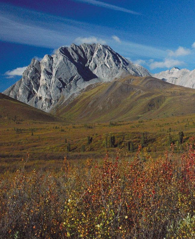
258
Taiga Shield Ecosystem Classification Group
 EC O LO GI C A L REGI O N S O F T HE N O RT HWE S T T ERRI TO RIE S Taiga Shield Ecosystem Classification Group Department of Environment and Natural Resources Government of the Northwest Territories 2008
Taiga Plains Ecosystem Classification Group
 EC O LO GI C A L REGI O N S O F T HE N O RT HWE S T T ERRI TO RIE S Taiga Plains Ecosystem Classification Group Department of Environment and Natural Resources Government of the Northwest Territories Revised
Birch Point Provincial Park. Management Plan
 Birch Point Provincial Park Management Plan 2 Birch Point Provincial Park Table of Contents 1. Introduction... 3 2. Park History... 3 3. Park Attributes... 4 3.1 Natural... 4 3.2 Recreational... 4 4. Park
Wallace Lake Provincial Park. Management Plan
 Wallace Lake Provincial Park Management Plan 2 Wallace Lake Provincial Park Table of Contents 1. Introduction... 3 2. Park History... 3 3. Park Attributes... 4 3.1 Natural... 4 3.2 Recreational... 4 4.
Section 2 North Slope Ecoregions and Climate Scenarios
 Section 2 North Slope Ecoregions and Climate Scenarios North Slope Ecoregions The geographic/ecological scope of the workshop will be freshwater and terrestrial systems of the North Slope of Alaska, with
Marchand Provincial Park. Management Plan
 Marchand Provincial Park Management Plan 2 Marchand Provincial Park Table of Contents 1. Introduction... 3 2. Park History... 3 3. Park Attributes... 4 3.1 Natural... 4 3.2 Recreational... 4 3.3 Additional
Pinawa Provincial Park. Draft Management Plan
 Pinawa Provincial Park Draft Management Plan Pinawa Provincial Park Draft Management Plan Table of Contents 1. Introduction... 3 2. Park History... 3 3. Park Attributes... 4 3.1 Natural... 4 3.2 Recreational...
3.0 THE NORTH SASKATCHEWAN IN ALBERTA
 3.0 THE NORTH SASKATCHEWAN IN ALBERTA 3.1 WATERSHED OVERVIEW Wherever you are on earth, you are in a watershed. Most of the rain and snow falling outside your window will eventually find its way to a local
2.0 PARK VISION AND ROLES
 2.0 PARK VISION AND ROLES 2.1 Significance in the Protected Area System Marble Range and Edge Hills provincial parks protect 6.8% of the Pavillion Ranges Ecosection, which is located in the Southern Interior
Wallace Lake Provincial Park. Draft Management Plan
 Wallace Lake Provincial Park Draft Management Plan Wallace Lake Provincial Park Draft Management Plan Table of Contents 1. Introduction... 3 2. Park History... 3 3. Park Attributes... 4 3.1 Natural...
BIG ANIMALS and SMALL PARKS: Implications of Wildlife Distribution and Movements for Expansion of Nahanni National Park Reserve. John L.
 BIG ANIMALS and SMALL PARKS: Implications of Wildlife Distribution and Movements for Expansion of Nahanni National Park Reserve John L. Weaver Conservation Report No.1 July 2006 4 SUMMARY The boundaries
EXPLORING BIOMES IN GORONGOSA NATIONAL PARK
 EXPLORING BIOMES IN GORONGOSA NATIONAL PARK ABOUT THIS WORKSHEET This worksheet complements the Click and Learn Gorongosa National Park Interactive Map (http://www.hhmi.org/biointeractive/gorongosa-national-park-interactive-map),
Mackinnon Esker Ecological Reserve Draft - Management Plan
 Mackinnon Esker Ecological Reserve Draft - Management Plan May 2011 Photo Credit: This document replaces the direction provided in the Carp Lake Provincial Park and Protected Area and Mackinnon Esker Ecological
Whitemouth Falls Provincial Park. Draft Management Plan
 Whitemouth Falls Provincial Park Draft Management Plan Whitemouth Falls Provincial Park Draft Management Plan Table of Contents 1. Introduction... 3 2. Park History... 3 3. Park Attributes... 4 3.1 Natural...
Hudson Bay Lowlands Proposed Protected Areas
 Hudson Bay Lowlands Proposed Protected Areas Hudson Bay Lowlands Proposed Protected Areas The Protected Areas Initiative has identified portions of the Hudson Bay Lowlands region that have significant
Jan Lake Representative Area -- Concept Management Plan --
 Jan Lake Representative Area -- Concept Management Plan -- Saskatchewan Environment and Resource Management December, 1999 Saskatchewan s Representative Areas Network Program The government of Saskatchewan,
AURORA WILDLIFE RESEARCH
 AURORA WILDLIFE RESEARCH Kim Poole 2305 Annable Rd. Nelson, BC, V1L 6K4 Canada Tel: (250) 825-4063; Fax: (250) 825-4073 e-mail: klpoole@shaw.ca 27 April 2005 Mike Gall Conservation Specialist and Glenn
Mackinnon Esker Ecological Reserve. Management Plan
 Mackinnon Esker Ecological Reserve Management Plan March 2017 Cover Page Photo Credit: Rob Bell This document replaces the direction provided in the Carp Lake Provincial Park and Protected Area and Mackinnon
What Is An Ecoregion?
 Ecoregions of Texas What Is An Ecoregion? Ecoregion a major ecosystem with distinctive geography, characteristic plants and animals, and ecosystems that receives uniform solar radiation and moisture Sometimes
South Atikaki Provincial Park. Draft Management Plan
 South Atikaki Provincial Park Draft Management Plan South Atikaki Provincial Park Draft Management Plan Table of Contents 1. Introduction... 3 2. Park History... 3 3. Park Attributes... 3 3.1 Natural...
PROPOSED EXPANSION OF NAHANNI NATIONAL PARK RESERVE
 PROPOSED EXPANSION OF NAHANNI NATIONAL PARK RESERVE Boundary Options October 2007 Since 2004, the Nahanni Expansion Working Group (NEWG) has been overseeing feasibility studies for the proposed expansion
1. Landforms. The Boreal Shield. Location The Boreal Shield can be found from Alberta to Newfoundland, between the Taiga Shield and the Boreal Plains.
 The Boreal Shield Location The Boreal Shield can be found from Alberta to Newfoundland, between the Taiga Shield and the Boreal Plains. 1. Landforms Rolling hills Exposed bedrock Evidence of glacial weathering
Pembina Valley Provincial Park. Draft Management Plan
 Pembina Valley Provincial Park Draft Management Plan 2 Pembina Valley Provincial Park Table of Contents 1. Introduction... 3 2. Park History... 3 3. Park Attributes... 3 3.1 Natural... 3 3.2 Recreational...
Environmental Development of River Road Ranch
 Environmental Development of River Road Ranch New Braunfels, Texas Alix Scarborough GEO 3426 April 2012 Introduction The 2,400-acre Word-Borcher ranch has been owned by the Word family since 1941. Located
Watchorn Provincial Park. Management Plan
 Watchorn Provincial Park Management Plan 2 Watchorn Provincial Park Table of Contents 1. Introduction... 3 2. Park History... 3 3. Park Attributes... 3 3.1 Natural... 4 3.2 Recreational... 4 3.3 Additional
FINGER-TATUK PROVINCIAL PARK
 FINGER-TATUK PROVINCIAL PARK PURPOSE STATEMENT AND ZONING PLAN March 2003 FINGER-TATUK PROVINCIAL PARK Purpose Statement and Zoning Plan Finger-Tatuk Provincial Park is 17,151 ha in size. It includes the
Dragon Mountain Park. Management Plan. Public Review Draft
 Disclaimer: This draft management plan contains preliminary proposals that are subject to change and therefore may not necessarily reflect the position of the Ministry of Environment. At the conclusion
Ecological Land Classification Primer
 Ecological Land Classification Primer Central and Southern Ontario Ecological Land Classification Internationally, various systems exist to delineate natural regions based on ecological factors. In Ontario,
Seager Wheeler Lake. Representative Area. -- Concept Management Plan --
 Seager Wheeler Lake Representative Area -- Concept Management Plan -- Saskatchewan Environment and Resource Management January, 1999 Saskatchewan s Representative Areas Network Program The Government of
Mapping the Snout. Subjects. Skills. Materials
 Subjects Mapping the Snout science math physical education Skills measuring cooperative action inferring map reading data interpretation questioning Materials - rulers - Mapping the Snout outline map and
Conservation Area Management Statement
 Conservation Area Management Statement Miller Creek Wildlife Area Resolution #: Approval: Issue Date: Date of Last Revision: Table of Contents 1. Purpose....... 1 2. Property Description...... 1 2.1. Legal
Bridge River Delta Park. Management Plan. Final Public Review Draft
 Bridge River Delta Park Management Plan Final Public Review Draft March 2016 Bridge River Delta Park Management Plan Approved by: Jeff Leahy Regional Director Thompson Cariboo Region BC Parks Date Brian
Boatswain bay biodiversity reserve
 Boatswain bay biodiversity reserve March 2003 1 1. Plan and description 1.1. Geographic location, boundaries and dimensions The plan of the proposed Boatswain bay biodiversity reserve and its location
2.0 Physical Characteristics
 _ 2.0 Physical Characteristics 2.1 Existing Land Use for the Project The site is comprised of approximately 114 acres bounded by Highway 101 to the north, the existing town of Los Alamos to the east, State
NOTICE OF INTENT MAPS WITH DESCRIPTIONS
 NOTICE OF INTENT MAPS WITH DESCRIPTIONS Location Map(s) to Accompany Notice of Intent The small corner map embedded in the lower left corner of the large map above shows the location of the three national
MANAGEMENT DIRECTION STATEMENT
 Lower Mainland District MAAGEMET DIRECTIO STATEMET January 2001 for Liumchen Ecological Reserve Ministry of Environment Lands and Parks BC Parks Division Table of Contents Page Introduction... 1 Purpose
Visual and Sensory Aspect
 Updated All Wales LANDMAP Statistics 2017 Visual and Sensory Aspect Final Report for Natural Resources Wales February 2018 Tel: 029 2043 7841 Email: sw@whiteconsultants.co.uk Web: www.whiteconsultants.co.uk
"ST. KLIMENT OHRIDSKI FACULTY OF GEOLOGY AND GEOGRAPHY
 SOFIA UNIVERSITY "ST. KLIMENT OHRIDSKI FACULTY OF GEOLOGY AND GEOGRAPHY APPLICATION OF THE MODEL "DRIVING FORCES PRESSURE STATE - RESPONSE FOR ASSESSMENT OF FLOOD RISK RADOSTINA BORISOVA DOCHEVA Bachelor
Specification for Grip blocking using Peat Dams
 Technical Guidance Note 1 Specification for Grip blocking using Peat Dams 1. Introduction Moorland drains (grips) have been dug across much of the Yorkshire upland peatlands. Many of these grips have become
Settlement Patterns West of Ma ax Na, Belize
 SETTLEMENT PATTERNS WEST OF MA AX NA, BELIZE 1 Settlement Patterns West of Ma ax Na, Belize Minda J. Hernke Faculty Sponsor: Kathryn Reese-Taylor, Department of Sociology/Archaeology ABSTRACT The focus
ALBERTA S GRASSLANDS IN CONTEXT
 ALBERTA S GRASSLANDS IN CONTEXT GLOBAL GRASSLANDS 1 Temperate grasslands, located north of the Tropic of Cancer and south of the Tropic of Capricorn, are one of the world s great terrestrial biomes 2.
Ottertooth CONSERVATION RESERVE C2262 STATEMENT OF CONSERVATION INTEREST. Ministry of Natural Resources. Thunder Bay District.
 Ottertooth CONSERVATION RESERVE C2262 STATEMENT OF CONSERVATION INTEREST Ministry of Natural Resources Thunder Bay District January 2003 Information Management By Jason Biggar Thunder Bay District Ottertooth
PRIORITY HABITAT SURVEY 2017 SWALEDALE. Summary. July 2018
 PRIORITY HABITAT SURVEY 2017 SWALEDALE Summary July 2018 Conservation & Monitoring Report No: Lead Author(s): Tony Serjeant & Sue Thurley Incorporating comments from: Gary Smith & Gordon Haycock (16/07/18)
A GIS Analysis of Probable High Recreation Use Areas in Three Sisters Wilderness Deschutes and Willamette National Forests
 Lindsey Kiesz Geo 565 Term Project 3/15/2010 A GIS Analysis of Probable High Recreation Use Areas in Three Sisters Wilderness Deschutes and Willamette National Forests Introduction The Three Sisters Wilderness
Dr. Melissa Grigione And Kurt Menke. Jaguar -Arturo. Jaguarundi -Arturo. Ocelot -Arturo. Caso. Caso. Caso
 Identifying Priority Conservation Areas in the U.S.- Mexico Border Region for America s Neotropical Cats, the Jaguar, Jaguarundi and Ocelot: An International Effort Dr. Melissa Grigione And Kurt Menke
Alpine Glacial Features along the Chimney Pond Trail, Baxter State Park, Maine
 Maine Geologic Facts and Localities September, 2009 Alpine Glacial Features along the Chimney Pond Trail, Baxter State Park, Maine 45 54 57.98 N, 68 54 41.48 W Text by Robert A. Johnston, Department of
TERRITORIES: BACKGROUND REPORT. Submitted to the NWT Recreation and Parks Association by Avens Associates Ltd.
 TRAILS in the NORTHWEST TERRITORIES: BACKGROUND REPORT Submitted to the NWT Recreation and Parks Association by Avens Associates Ltd. i TRAILS in the NORTHWEST TERRITORIES: BACKGROUND REPORT Report to:
Numaykoos Lake Provincial Park. Management Plan
 Numaykoos Lake Provincial Park Management Plan 2 Numaykoos Lake Provincial Park Table of Contents 1. Introduction... 3 2. Background... 3 3. Park Purpose... 5 4. Park Management Guidelines... 6 Appendix...
International Snow Science Workshop
 A PRACTICAL USE OF HISTORIC DATA TO MITIGATE WORKER EXPOSURE TO AVALANCHE HAZARD Jake Elkins Jackson Hole Mountain Resort, Teton Village, Wyoming Bob Comey* Jackson Hole Mountain Resort, Teton Village,
DRAFT TEN August 23 rd, Climate Change Impacts On The Alpine: The Future of Our Mountains
 DRAFT TEN August 23 rd, 2006 Climate Change Impacts On The Alpine: The Future of Our Mountains Introduction In imagining the impacts of climate change, think of where the dawn s light first strikes at
HYDROLOGY OF GLACIAL LAKES, FORT SISSETON AREA
 PROC. S.D. ACAD. SCI., VOL. 77 (1998) 59 HYDROLOGY OF GLACIAL LAKES, FORT SISSETON AREA Perry H. Rahn Department of Geology & Geological Engineering South Dakota School of Mines and Technology Rapid City,
ANAGEMENT. LAN November, 1996
 M ANAGEMENT P LAN November, 1996 for Paul Lake Provincial Park Ministry of Environment, Lands and Parks BC Parks Department Paul Lake Provincial Park M ANAGEMENT P LAN Prepared by BC Parks Kamloops Area
26 Utah s Patchwork Parkway SCENIC BYWAY CORRIDOR MANAGEMENT PLAN (SR 143)
") Natural Natural Quality applies to those features in the visual environment that are in a relatively undisturbed state. These features predate the arrival of human populations and may include geological
Natural Natural Quality applies to those features in the visual environment that are in a relatively undisturbed state. These features predate the arrival of human populations and may include geological
Labrador - Island Transmission Link Target Rare Plant Survey Locations
 27-28- Figure: 36 of 55 29-28- Figure: 37 of 55 29- Figure: 38 of 55 #* Figure: 39 of 55 30- - east side Figure: 40 of 55 31- Figure: 41 of 55 31- Figure: 42 of 55 32- - secondary Figure: 43 of 55 32-
TO THE WORLD HERITAGE LIST. Convention concerning the Protection of the World Cultural and Natural Heritage
 NOMINATION TO THE WORLD HERITAGE LIST Convention concerning the Protection of the World Cultural and Natural Heritage Name I CANADIAN ROCKIES Identification No, 304 Date received by WH Secretariat, 23.12.83
MEASURING ACCESSIBILITY TO PASSENGER FLIGHTS IN EUROPE: TOWARDS HARMONISED INDICATORS AT THE REGIONAL LEVEL. Regional Focus.
 Regional Focus A series of short papers on regional research and indicators produced by the Directorate-General for Regional and Urban Policy 01/2013 SEPTEMBER 2013 MEASURING ACCESSIBILITY TO PASSENGER
Colorado Life Zone Scavenger Hunt
 Colorado Life Zone Scavenger Hunt Below are worksheets created for all the habitats or life zones. They were designed with the intention of breaking the class up into small groups, and having students
MIDDLE SCHOOL CURRICULUM TR AILING ICE AGE M YST ERI E S ICE AGE TREKKING
 MIDDLE SCHOOL CURRICULUM TR AILING ICE AGE M YST ERI E S ICE AGE TREKKING CONTENTS I. Enduring Knowledge... 3 II. Teacher Background... 3 III. Before Viewing this Video... 5 IV. Viewing Guide... 5 V. Discussion
Glaciers. Reading Practice
 Reading Practice A Glaciers Besides the earth s oceans, glacier ice is the largest source of water on earth. A glacier is a massive stream or sheet of ice that moves underneath itself under the influence
2.1 Physical and Biological Description Matabitchuan River Watershed
 2.1 Physical and Biological Description Watershed 2.1.1 Physical Description The system watershed has a total area of about 933 km 2 and is a tributary system to Lake Temiskaming and the Ottawa River Drainage
Chapter 14. The Physical Geography of Russia
 Chapter 14 The Physical Geography of Russia Chapter Objectives Identify the physical features and natural resources of Russia. Discuss the effects of Russia s climate and vegetation on life in the region.
Bayview Escarpment. Interim Management Statement
 Bayview Escarpment Interim Management Statement Bayview Escarpment Provincial Nature Reserve Interim Management Statement January 15, 1995 REGIONAL DIRECTOR'S APPROVAL STATEMENT This Interim Management
Lidar Imagery Reveals Maine's Land Surface in Unprecedented Detail
 Maine Geologic Facts and Localities December, 2011 Lidar Imagery Reveals Maine's Land Surface in Unprecedented Detail Text by Woodrow Thompson, Department of Agriculture, Conservation & Forestry 1 Introduction
Region 1 Piney Woods
 Region 1 Piney Woods Piney Woods 1. This ecoregion is found in East Texas. 2. Climate: average annual rainfall of 36 to 50 inches is fairly uniformly distributed throughout the year, and humidity and temperatures
Beaver Creek Provincial Park. Management Plan
 Beaver Creek Provincial Park Management Plan 2 Beaver Creek Provincial Park Table of Contents 1. Introduction... 3 2. Park History... 3 3. Park Attributes... 4 3.1 Natural... 4 3.2 Recreational... 4 4.
As outlined in the Tatshenshini-Alsek Park Management Agreement, park management will:
 Management Strategy General Strategy The priority management focus for the park is to ensure that its internationally significant natural, cultural heritage and recreational values are protected and that
Recreation Opportunity Analysis Authors: Mae Davenport, Ingrid Schneider, & Andrew Oftedal
 Authors: Mae Davenport, Ingrid Schneider, & Andrew Oftedal // 2010 Supply of Outdoor Recreation Resources // Recreation Location Quotient Analysis recreation opportunity analysis // 59 2010 Supply of Outdoor
The Role of Glaciers in the Hydrologic Regime of the Nepal Himalaya. Donald Alford Richard Armstrong NSIDC Adina Racoviteanu NSIDC
 The Role of Glaciers in the Hydrologic Regime of the Nepal Himalaya Donald Alford Richard Armstrong NSIDC Adina Racoviteanu NSIDC Outline of the talk Study area and data bases Area altitude distributed
Dragon Mountain Park. Management Plan
 Dragon Mountain Park Management Plan December 2015 Dragon Mountain Park Management Plan Approved by: Peter Weilandt A/Regional Director Thompson Cariboo Region BC Parks December 14. 2015 Date Brian Bawtinheimer
There are actually six geographic sub-regions, three in both the uplands and the lowlands.
 6 Regions of AR Although Arkansas is most easily divided into two distinct geographical regions, the northwestern uplands and the southeastern lowlands, this description does not accurately portray the
I AN INTRODUCTION TO THE SOUTH SASKATCHEWAN RIVER BASIN
 I AN INTRODUCTION TO THE SOUTH SASKATCHEWAN RIVER BASIN I.1 The Saskatchewan River Basin The South Saskatchewan River joins the North Saskatchewan River to form one of the largest river systems in western
EXPLORING EARTH S SURFACE. Lesson 4
 EXPLORING EARTH S SURFACE Lesson 4 Introduction Lewis and Clark In 1804, an expedition set out from near Saint Louis to explore the land between the Mississippi River and the Pacific Ocean, The United
COUNTRY CASE STUDIES: OVERVIEW
 APPENDIX C: COUNTRY CASE STUDIES: OVERVIEW The countries selected as cases for this evaluation include some of the Bank Group s oldest (Brazil and India) and largest clients in terms of both territory
Planning Wildlife Crossings in Canada's Mountain Parks SESSION: Highway Mitigation: new insights for practitioners
 Planning Wildlife Crossings in Canada's Mountain Parks ID95 SESSION: Highway Mitigation: new insights for practitioners Trevor Kinley, Project Manager Lake Louise Yoho Kootenay Field Unit, Parks Canada
What is Pimachiowin Aki? What is The Land that Gives Life?
 What is Pimachiowin Aki? What is The Land that Gives Life? Pimachiowin Aki is Canada s newest and first mixed (cultural and natural) World Heritage Site. In Anishaabemowin, the Ojibwe language, Pimachiowin
Oak Ridges Moraine: Southern Ontario's Sponge
 Oak Ridges Moraine: Southern Ontario's Sponge Lesson Overview Students will examine the location and the importance of the Oak Ridges Moraine and investigate ongoing conflicts concerning its development.
Role of the Protected Area
 Role of the Protected Area Provincial and Regional Context Height of the Rockies and Elk Lakes provincial parks lie in southeastern British Columbia in the Rocky Mountains, about 85 km southwest of Calgary,
TOURISM SPENDING IN ALGONQUIN PROVINCIAL PARK
 TOURISM SPENDING IN ALGONQUIN PROVINCIAL PARK Margaret E. Bowman 1, Paul F.G. Eagles 2 1 Ontario Parks Central Zone, 451 Arrowhead Park Road, RR3, Huntsville, ON P1H 2J4, 2 Department of Recreation and
Designated Sites. Headlines
 Designated Sites Headlines Over 36% of the Sheffield district is covered by sites with European, national or local designation. These offer valuable habitats to wildlife, with some level of protection,
RESEARCH AND PLANNING FORT STEELE HERITAGE TOWN VISITOR STUDY 2007 RESULTS. May 2008
 RESEARCH AND PLANNING FORT STEELE HERITAGE TOWN VISITOR STUDY 2007 RESULTS May 2008 Research and Planning Tourism British Columbia 300-1803 Douglas St. Box 9830 Stn. Prov. Gov t. Victoria, BC V8W 9W5 Web:
GEOGRAPHY AND HISTORY
 GEOGRAPHY AND HISTORY YEAR 1, PART 1 www.vicensvives.es Contents 01 Our planet Earth 02 The representation of the Earth: maps 03 The Earth s relief 04 Rivers and seas 05 Weather and climate 06 Climates
STONE MOUNTAIN PROVINCIAL PARK Purpose Statement and Zoning Plan
 1 STONE MOUNTAIN PROVINCIAL PARK Purpose Statement and Zoning Plan Stone Mountain Provincial Park is situated 140 km west of Fort Nelson at Kilometre 595 of the Alaska Highway. The 25 690 ha park is located
Pillar Park. Management Plan
 Pillar Park Management Plan January 2014 Pillar Park Management Plan Approved by: Jeff Leahy Regional Director Thompson Cariboo Region BC Parks January 9, 2014 Date Brian Bawtinheimer Executive Director
Monday, December 11, 2017
 Monday, December 11, 2017 Physical Geography of Russia Objective: complete Warm-Up, write outline notes and discuss the geography of Eastern Europe/mother Russia and view Geography Now: Belarus. География
Map 1.1 Wenatchee Watershed Land Ownership
 Map 1.1 Wenatchee Watershed Land Ownership Map 1.1 Wenatchee Watershed Land Ownership The Wenatchee watershed lies in the heart of Washington state in Chelan County. Just larger than the state of Rhode
Biosphere Reserves of India : Complete Study Notes
 Biosphere Reserves of India : Complete Study Notes Author : Oliveboard Date : April 7, 2017 Biosphere reserves of India form an important topic for the UPSC CSE preparation. This blog post covers all important
SUMMER VILLAGE OF SILVER SANDS. Municipal Development Plan
 SUMMER VILLAGE OF SILVER SANDS Municipal Development Plan Bylaw 253-2014 Adopted August 22, 2014 Summer Village of Silver Sands Municipal Development Plan Bylaw No. 253-2014 Page 2 1 INTRODUCTION 1.1 SETTING
1 INFORMATION REQUIREMENTS
 1 INFORMATION REQUIREMENTS 1.1 BACKGROUND 2 1.2 WHAT IS THE DISTRICT PLAN 3 1.3 DISTRICT PLAN STRUCTURE 4 1.4 HOW TO USE THE DISTRICT PLAN 5 1.5 STRATEGIC FRAMEWORK 6 Whanganui District Plan (15 January
CRAZY HORSE TRAIL GUIDE
 CRAZY HORSE TRAIL GUIDE Abridged Version: July 2016 This is a short form of our interpretive trail guide for the Crazy Horse Trail. The full version of the guide has a more detailed description of the
Fraser River Provincial Park Purpose Statement and Zoning Plan
 Fraser River Provincial Park Purpose Statement and Zoning Plan Fraser River Provincial Park is located on the west bank of the Fraser River, approximately 35 km south of Prince George. This 4,899 ha Protected
The Geological Pacific Northwest. Wednesday February 6, 2012 Pacific Northwest History Mr. Rice
 The Geological Pacific Northwest Wednesday February 6, 2012 Pacific Northwest History Mr. Rice 1 Free Response #2 Please do not simply list the items for this response. Full sentences!!! Minimum of 3-5
628: BELOVEZHSKAYA PUSHCHA STATE NATIONAL PARK (BELARUS)
") WORLD HERITAGE NOMINATION - IUCN SUMMARY 628: BELOVEZHSKAYA PUSHCHA STATE NATIONAL PARK (BELARUS) Summary prepared by WCMC/IUCN (April 1992) based on the original nomination submitted by the Government
WORLD HERITAGE NOMINATION - IUCN SUMMARY 628: BELOVEZHSKAYA PUSHCHA STATE NATIONAL PARK (BELARUS) Summary prepared by WCMC/IUCN (April 1992) based on the original nomination submitted by the Government
Evaluation of Woodland Caribou Winter Range in Mount Robson Provincial Park (Keystone Wildlife Research 1998)
") MOUNT ROBSON PROVINCIAL PARK Appendix 8. Evaluation of Woodland Caribou Winter Range in Mount Robson Provincial Park (Keystone Wildlife Research 1998) Introduction Background and Objectives The Mount Robson
MOUNT ROBSON PROVINCIAL PARK Appendix 8. Evaluation of Woodland Caribou Winter Range in Mount Robson Provincial Park (Keystone Wildlife Research 1998) Introduction Background and Objectives The Mount Robson
Rocky Lake Provincial Park. Draft Management Plan
 Rocky Lake Provincial Park Draft Management Plan Rocky Lake Provincial Park Draft Management Plan Table of Contents 1. Introduction... 3 2. Park History... 3 3. Park Attributes... 4 3.1 Location/Access...4
Sasagiu Rapids Provincial Park. Draft Management Plan
 Sasagiu Rapids Provincial Park Draft Management Plan 2 Sasagiu Rapids Provincial Park Table of Contents 1. Introduction... 3 2. Background and Park Attributes... 3 2.1 Park History.... 3 2.2 Natural Features...
Ouimet Canyon Provincial Nature Reserve. Management Plan
 Ouimet Canyon Provincial Nature Reserve Management Plan NOTE: This document has been scanned and formatted, and therefore is slightly different from the original version. -March 2002 Additional copies
Order of the Minister of Environment #39, August 22, 2011 Tbilisi
 Registration Code 360050000.22.023.016080 Order of the Minister of Environment #39, August 22, 2011 Tbilisi On preparatory stages and procedure of the methodology for Elaborating structure, content and
Kwadacha Wilderness Provincial Park and Kwadacha Addition (Kwadacha Recreation Area) Purpose Statement and Zoning Plan
 Purpose Statement and Zoning Plan") Kwadacha Wilderness Provincial Park and Kwadacha Addition (Kwadacha Recreation Area) Purpose Statement and Zoning Plan Located in a remote area of the northern interior of BC, this large park straddles
Kwadacha Wilderness Provincial Park and Kwadacha Addition (Kwadacha Recreation Area) Purpose Statement and Zoning Plan Located in a remote area of the northern interior of BC, this large park straddles
PLUMPER COVE MARINE PARK MASTER PLAN
 Lower Mainland Region Park Operations Branch Parks and Outdoor Recreation Division Ministry of Lands, Parks and Housing North Vancouver, B.C. PLUMPER COVE MARINE PARK MASTER PLAN DECEMBER, 1980 PLUMPER
Paul Griffiths 544 Springbok Road Campbell River British Columbia CANADA V9W 8A2
 Paul Griffiths 544 Springbok Road Campbell River British Columbia CANADA V9W 8A2 Phone: 250-923-1311 Fax: 250-923-6211 Email: pgriff@island.net BC Ministry of Environment Environmental Assessment Office