I AN INTRODUCTION TO THE SOUTH SASKATCHEWAN RIVER BASIN
|
|
|
- MargaretMargaret McDowell
- 6 years ago
- Views:
Transcription
1 I AN INTRODUCTION TO THE SOUTH SASKATCHEWAN RIVER BASIN I.1 The Saskatchewan River Basin The South Saskatchewan River joins the North Saskatchewan River to form one of the largest river systems in western Canada, the Saskatchewan River System, which flows from the headwater regions along the Rocky Mountains of south-west Alberta and across the prairie provinces of Canada (Alberta, Saskatchewan, and Manitoba). The Prairie physiographic region is characterized by rich soils, thick glacial drift and extensive aquifer systems, and a consistent topography of broad rolling hills and low gradients which create isolated surface wetlands. In contrast, the headwater region of the Saskatchewan River (the Western Cordillera physiographic region) is dominated by thin mineral soils and steep topography, with highly connected surface drainage systems and intermittent groundwater contributions to surface water systems. As a result, the Saskatchewan River transforms gradually in its course across the provinces: from its oxygen-rich, fast flowing and highly turbid tributaries in Alberta to a meandering, nutrient-rich and biologically diverse prairie river in Saskatchewan. There are approximately 3 million people who live and work in the Saskatchewan River Basin and countless industries which operate in the basin as well, including pulp and paper mills, forestry, oil and gas extraction, mining (coal, potash, gravel, etc.), and agriculture. As the fourth longest river system in North America, the South Saskatchewan River Basin covers an incredibly large area, draining a surface of approximately km² (Partners FOR the Saskatchewan River Basin, 2009). Most of the water that flows in the Saskatchewan River originates in the Rocky Mountains of the Western Cordillera, although some recharge occurs in the prairie regions of Alberta and Saskatchewan through year-round groundwater contributions, spring snow melt in March or April, and summer rainfall in May and early July (J.W. Pomeroy, D. de Boer, and L.W. Martz, 2005). Generally, there is little local runoff in the prairie regions to the Saskatchewan River, however, particularly during years with little precipitation. As a result, the flow in the river relies heavily on the contributions from Alberta s snowpack and summer rains which fall in the mountains, and in turn, future water supply in this river will be sensitive to climate changes that affect the precipitation in western regions of Canada. Page 5
2 Page 6

3 I.1.i Water Use Water allocation in the Alberta portion of the South Saskatchewan River Basin has been effectively closed by the government of Alberta. As of 2007, the Minister of Alberta Environment decreed that all un-allocated water in the Oldman, Bow, and South Saskatchewan River sub basins be restricted for use by First Nations, provincial Water Conservation Objectives, storage development in support of improved aquatic ecosystems or for currently license holders, or to honor existing applications, with no new applications or licenses to be accepted by the ministry (AMEC, 2009). Total licensed water allocation for the South Saskatchewan River sub basin is dam³ form surface water, and dam³ from groundwater (Partners FOR the Saskatchewan River Basin, 2009). Approximately 45% of the total population in Saskatchewan relies on the South Saskatchewan River for their daily water needs. The single largest water license from the South Saskatchewan River is for the Queen Elizabeth Power Station, followed closely by the Medicine Hat thermal generating station. The largest water loss from the South Saskatchewan River System is evaporative losses from Lake Diefenbaker. Although this is a natural process, the large surface area of Lake Diefenbaker (a man-made reservoir) is a contributing factor. Water users from the South Saskatchewan River include municipalities supplying drinking water, diversions to the Qu-Appelle River System for use in the southern portions of the province (including Regina and Moose Jaw), irrigation for agriculture, and industrial water users (figure 1). Figure 1: Water allocation and consumption from surface water in the South Saskatchewan River Basin, Partners FOR the Saskatchewan River Basin, 2009 (figure 9.4). Page 7
. Figure 2: State of the Watershed Report 2010, figure 126.")
4 According to the State of the Watershed Report by Saskatchewan Environment (figure 2), average domestic water consumption for the South Saskatchewan River Basin is higher than most other watersheds in Saskatchewan, at more than 479 litres per person, per day (Saskatchewan Watershed Authority, 2010). Figure 2: State of the Watershed Report 2010, figure 126. Estimate of per capita daily water consumption (residential, business and municipal use) by watershed. Page 8
5 Page 9
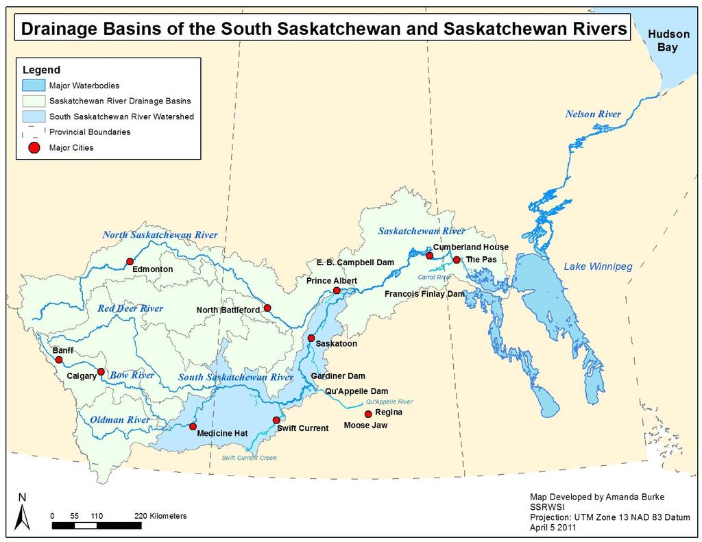
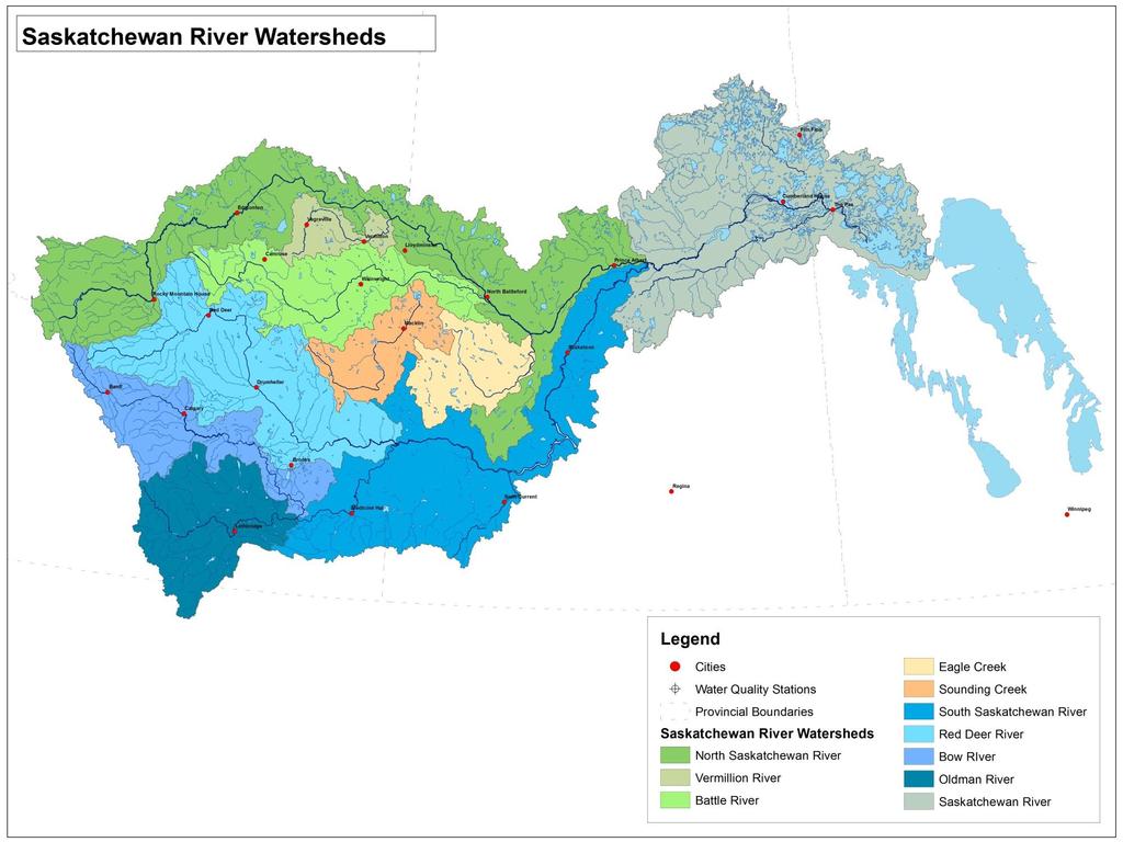
6 I.2 Drainage Basins of the Saskatchewan River Based on surface topography which ultimately drives the direction of surface water flow, the Saskatchewan River can be divided into several drainage basins. The two major tributaries of the Saskatchewan River are the North and South Saskatchewan Rivers, which are fed by a number of smaller tributaries and their associated drainage areas. The North Saskatchewan River includes flow from the tributaries of the Vermillion River and Battle River. Although the drainage basins of Sounding Creek and Eagle Creek are sometimes considered part of the North Saskatchewan River s total drainage, they are not directly connected to it. The South Saskatchewan River is fed by three major tributaries: the Red Deer River, Bow River, and Oldman River systems. Downstream of the confluence of the North and South Saskatchewan Rivers, the Saskatchewan River flows through the Saskatchewan Delta into Manitoba, then down into Lake Winnipeg and eventually drains into Hudson s Bay through the Nelson River. There are several major cities which are located on the banks of the South Saskatchewan River and its tributaries, including the City of Banff and Canmore in the upper reaches of the Bow River, with Cochrane and the City of Calgary along the middle reaches. On the Oldman River, the largest city is the City of Lethbridge. The largest city on the Red Deer River is the City of Red Deer, followed by Drumheller. Communities along the South Saskatchewan River include the City of Medicine Hat, Town of Outlook, and the City of Saskatoon. The towns of Warman, Osler, and Martensville are located close to, but not actually on, the South Saskatchewan River. The City of Swift Current is located on Swift Current Creek, a major tributary of the South Saskatchewan River in Saskatchewan. Page 10
7 Page 11

8 I.3 Eco-sites and Eco-regions The National Ecological Framework for Canada established by the Ecological Stratification Working Group in 1995 (Ecological Stratification Working Group, 1995) specifies a total of 15 Ecozones and 194 Ecoregions for Canada. Ecozones include broad areas of Canada with similar physiographic and ecological characteristics, and includes the Arctic Cordillera, Northern Arctic, Southern Arctic, Taiga Plains, Taiga Shield, Boreal Shield, Atlantic Maritime, Mixed Wood Plains, Boreal Plains, Prairies, Taiga Cordillera, Boreal Cordillera, Pacific Maritime, Montane Cordillera, and the Hudson Plains regions. The approximate spatial extent for each these Ecozones is shown below: Page 12
9 Each Ecozone can be further divided into Ecoregions, of which there are 194 across the entirely of Canada. The division of each Ecoregion is based on a prominent set of biophysical, biological, climate, and physiographic features. Three Ecozones are contained within the boundary of the South Saskatchewan River basin: the Prairies, the Boreal Plains and the Montane Cordillera. The following discusses these Ecozones and the Ecoregions within them, as described by Ecological Stratification Working Group (1995), unless otherwise stated. I.3.i The Prairie Ecozone Characterized by the presence of open grasslands, this Ecozone is located in the southern part of Alberta, Saskatchewan and Manitoba, and extends through the majority of the Saskatchewan River Basin. It is consists of level to gently rolling plain, with limited forests, and a sub humid to semiarid climate. Historically dominated by native mixed-grass and fescue prairie, this region has been significantly altered by human development, with approximately 8O% of the region under cultivation (Acton et al, 1998). The climate in the Ecozone is considered Continental, ranging from sub humid to semi-arid with short hot summers and long cold winters, low levels of precipitation, and high evaporation. Mean annual temperatures range from 1.5 C to 3.5 C. The average winter temperature ranges between - 12 to -8 and average summer temperature are between 14 and 16. Average annual precipitation is quite varied, ranging from 250 mm to slightly less than 700mm. Agriculture is the dominant land use in this region, producing grains, oilseeds and animal products. Other activities in this Ecozone include mining (coal, potash, mineral), and oil and gas production. I.3.ii The Aspen Parkland Ecoregion This Ecoregion is considered to be a transition between the grasslands in the south to the boreal forest in the north, and can be found in the north-eastern and north western extent of the South Saskatchewan River Basin. Most of this region is now farmland, but in its native state the landscape Page 13
10 consisted of trembling aspen stands, mixed tall shrubs and intermittent fescue grasslands. This region has a humid continental climate with short, cold summer and long, cold winters, with a mean annual temperature of approximately 1.5 C. Mean annual precipitation ranges mm. Underlain by Cretaceous shale, Black Chernozemic soils prevail as a result of large contributions of organic matter from fescue grasslands and slower rates of decomposition due to the cooler climate. I.3.iii Moist Mixed Grassland Ecoregion This Ecoregion represents the northern extension of open grasslands in the Prairie Ecozone. It typically includes a broad plain, interrupted by deep valleys and hilly uplands. Brown Chernozemic soils are dominant, with areas of Soloetzic soils. Native grasslands are dominated by spear grass and wheat grass, with a variety of deciduous shrubs and aspen commonly occurring near wetlands. With semi-arid moisture conditions, the mean annual precipitation ranges from mm. The mean annual temperature is 2.5 C. I.3.iv Mixed Grassland Ecoregion This Ecoregion can be found large area of the South Saskatchewan River Basin, in southwestern Saskatchewan and southeastern Alberta. It is a semiarid region, conducive to short warm summers and long cool winters, with a mean annual temperature of 3.5 C and a mean annual precipitation that ranges mm. It is naturally vegetated by spear grass, blue grama grass, and wheat grass. The soils are mainly Brown Chernozemic with areas of Solonetzic soils. About half of this region is cultivated with the remainder being used as pasture or rangeland. I.3.v Cypress Upland Ecoregion Representing a relatively small area within the South Saskatchewan River Basin, this rolling upland is found in southeastern Alberta and southwestern Saskatchewan. This upland area rises abruptly in elevation above the surrounding plains. Only slightly altered by agricultural use, vegetation ranges from fescue and wheatgrass to mixed forests of lodgepole pine, white spruce and aspen. Dark Brown soils are found in the grasslands at the base of the upland, and Black and Dark Gray Page 14
11 soils are found on the top of the plateau. The climate is cooler and more moist than the surrounding grassland, with a mean annual temperature of approximately 3 C and a mean annual precipitation ranging between 325 and 450 mm. I.3.vi Fescue Grassland This region is found in southwestern Alberta along the face of the Rocky Mountain foothills. Lying within the Chinook belt, it has relatively mild, warm summers and winters. The mean annual temperature is approximately 3.5 C., with a mean annual precipitation ranging from mm. The fescue grassland is underlain by sandstones and shale with a surface of loamy glacial till and clayey lacustrine deposits, dominated by Chernozemic Black soils. Although much of the Ecoregion is cultivated, the native grassland consists of rough fescue, Parry oat grass, june grass and wheat grass with an abundance of forbes. I.3.vii The Montane Cordillera Ecozone This Ecozone is a mountainous and rugged region that extends from southern British Columbia to southwestern Alberta. It can be found in the western portion of the South Saskatchewan River Basin, and includes the Eastern Continental Ranges and the Northern Continental Divide Ecoregions. It is the most diverse and varied of all Ecozones, ranging from alpine tundra to dense conifer forests to dry sagebrush and grassland. Plains and valleys consist of glacial moraine and fluvial and lacustrine deposits, while mountains consist largely of culluvium and rock outcrops. The climate in this region varies with altitude, ranging from subarid to arid in southern, lower valleys to humid and cold at higher elevations and in northern reaches. Annual precipitation ranges from mm, while arid valleys and plateaus in the south may receive less than 300 mm. The mean annual temperature range can range between 0 C in the northwest, to 7 C in the Okanagan area. Page 15
12 Significant human activities include forestry operations, as well as mining, oil and gas production and tourism. Row crops and hay are grown near valley streams, where water is available for irrigation. Orchards and vineyards can be found in the southern valleys. I.3.viii Eastern Continental Divide Ecoregion This Ecoregion, found in the northwest corner of the South Saskatchewan River Basin, covers the eastern section of the Rocky Mountains of Alberta. This region is dominated by subalpine and alpine ecosystems with mixed forests of lodgepole pine, Engelmann spruce, and alpine fir. Douglas fir, aspen and grasslands can be found in the warmer, drier valley sites. Large mountain peaks are found around the Columbia ice field, with lower mountains to the south. Mountain ranges are linear with cliffs and precipitous faces and rock outcrops. Regosilic and Eutric Brunisolic soils are found on steeply sloping colluvial, morainal, and fluvioglacial deposits. The mean annual temperature is approximately 2.5 C. Mean annual precipitation ranges mm, increasing from east to west with elevation. Banff and Jasper National Parks and the Willmore Wilderness Provincial Park covers most of the Ecoregion, where tourism and recreation are the main human actives. Hunting and some forestry and resource exploration take place outside the boundaries of the parks. I.3.ix Northern Continental Divide Ecoregion This mountainous Ecoregion can be found along the Alberta-British Columbia Border, in the southwest portion of the South Saskatchewan River Basin. Elevations in this Ecoregion are between 1200 and 2000 meters above sea level. Winters are affected by frequent Chinooks. The mean annual temperature is approximately 3.5 C with a mean annual precipitation that ranges mm. Humo-Ferric Podzols and Dystric Brunisols soils are found on steeply-sloping colluvial, morainal and fluvioglacial deposits. Human activities include forestry, coal mining, hunting, recreation as well as limited agriculture and grazing. Page 16
13 I.3.x Boreal Plains Ecozone Extending across Western Canada from northwest British Columbia to the southeastern corner of Manitoba, this region is found in eastern Saskatchewan and western Alberta within the boundaries of the South Saskatchewan River Basin. It is covered by northern boreal forest. With continental climatic conditions, it is characterized by cold winters and moderately warm summers. The mean annual temperature ranges between -2 to 2 C. Mean annual precipitation ranges mm. Coniferous species are found throughout this Ecoregion include white and black spruce, jack pine and tamarack. Broadleaf trees such as white birch, trembling aspen, and balsam poplar are more numerous in the transitional section leading to the prairies in the south, while black spruce and tamarack increase in dominance along the northern sections. This nearly level plain consisting of hummocky to kettled glacial moraine and lacustrine deposits, underlain by Cretaceous shales. Soils consist largely of Luvisols, with Black Chernozems in the south and Brunisols in the north. Organic soils associated with wetlands, and peatlands are common. Much of the southern boundary of this Ecozone in used for agriculture. Other uses of this Ecozone include forestry, mining, oil and gas exploration, hunting and trapping, outdoor recreation and tourism. I.3.xi Boreal Transition Ecoregion Extending from central Alberta to southern Manitoba, this Ecoregion can be found in the north eastern and north western extent of the river basin boundary. Representing a transitional area between northern boreal forests and southern grasslands, this Ecoregion is classified by having a sub humid low boreal ecoclimate, characterized by warm summers and cold winters. The mean annual temperature is 1 C. Mean annual precipitation ranges from 450 mm in the west to 550 mm in the east. The landscape is characterized by undulating to gently sloping plains with a mix of dominantly deciduous boreal forest and farmland. Predominant soils include Gray Luvisols and Dark Gray Chenozemic. Page 17
14 I.3.xii Western Alberta Upland This Ecoregion occurs in west-central Alberta, in the western extent of the South Saskatchewan River Drainage Basin. The landscape is characterized by foothills consisting of rolling liner ridges and broad valleys that rise abruptly from the plains. The uplands are composed of Cretaceous sediments consist of Luvisolic soils with bare rock ridges and Gleysolic and Organic soils. Mean annual temperature is 2 C. Mean annual precipitation is approximately mm. It consists of mixed forests of lodgepole pine, trembling aspen, and white spruce with balsam poplar, paper birch and balsam fir. Dominant vegetation types depend greatly on location. Lodgpole pine and aspen occur on dry sites, while black spruce and tamarack are found on wetter sites. Conifers are associated with the cooler, higher elevations, while aspen is more common in the lower plains area. I.4 Dams and Reservoirs There are eight major reservoirs located on the Bow River created by man-made dams: Ghost Reservoir, Glenmore, Lake Minnewanka, Upper Kananaskis River, Barrier, Spray, Bearspaw and the Lower Kananaskis. On the Oldman River lies the Oldman River Dam and its associated reservoir. On the Red Deer River is the Dickson Dam which regulates Gleniffer Lake. The only reservoir on the South Saskatchewan River is Lake Diefenbaker, which is regulated by Gardiner Dam to the north, and the Qu Appelle Dam which is located on the eastern portion of the lake and supplies the Qu Appelle River. Both of these dams were opened in Considered the largest body of water in Southern Saskatchewan, Lake Diefenbaker is also the largest reservoir in both Alberta and Saskatchewan Gardiner Dam is considered the largest dam in either province as well. Page 18

15 Figure 3: The water towers of the Gardiner Dam, located on the northern shores of Lake Diefenbaker. I.5 Geology and Soils Nearly all the soil found in the South Saskatchewan River Watershed falls into the brown to dark brown Chernozemic soil classification. Limited zones of grey and black Chernozemic soils can be found in the north-eastern portion of the watershed near the confluence of the North and South Saskatchewan Rivers. Most of the soils in this watershed are fine or moderately fine textured, although large formations of sandy and coarse textures soils (Regosolic soils) are found along the South Saskatchewan River itself, and areas where sand dunes have migrated across the prairies, such as the western portion of the watershed and the area around the City of Saskatoon. Page 19
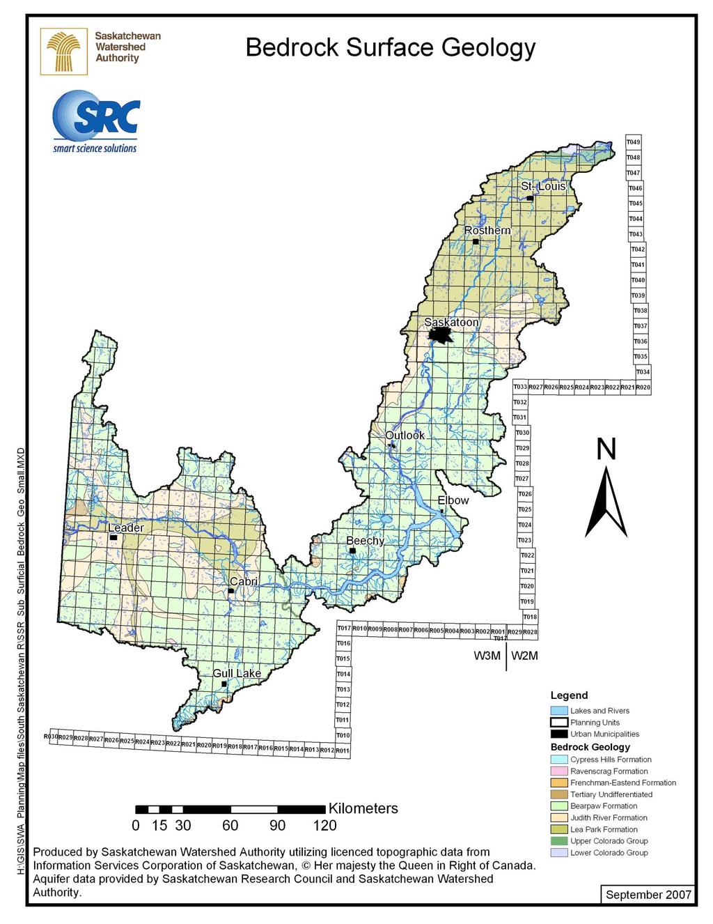
16 The well-developed soils of the South Saskatchewan River Watershed are located in the Moist Mixed Grasslands regions and support intensive and extensive agriculture, including crop production, forage production, and livestock operations. The South Saskatchewan River passes through the Prairie Ecozone which is characterized by its rich soils and thick glacial drift. Many of the features of this physiographic region were shaped over years ago during the last ice age, which covered most of Canada. Hills, plateaus, and escarpments are the result of areas where the bedrock has come to the surface and resisted erosion, but most of the watershed is covered by thick surficial material which provides the alternating layers of fine and course material that supports the formation of excellent groundwater aquifer systems. As a result, there are several aquifer formations in the South Saskatchewan River Watershed, including the Bear Paw Formation, Empress Formation, and the Sutherland Formation. Maps of these aquifers can be found in section I.5.i. Page 20
17 Page 21
18 Page 22

19 I.5.i Aquifers and Groundwater Figure 4: Map of major aquifers yielding potable water in Saskatchewan (Pomeroy, de Boer, Martz, 2005, pg. 21. Reproduced from the Atlas of Saskatchewan Project, University of Saskatchewan) Page 23
20 Page 24
21 Page 25
22 Page 26
23 Page 27
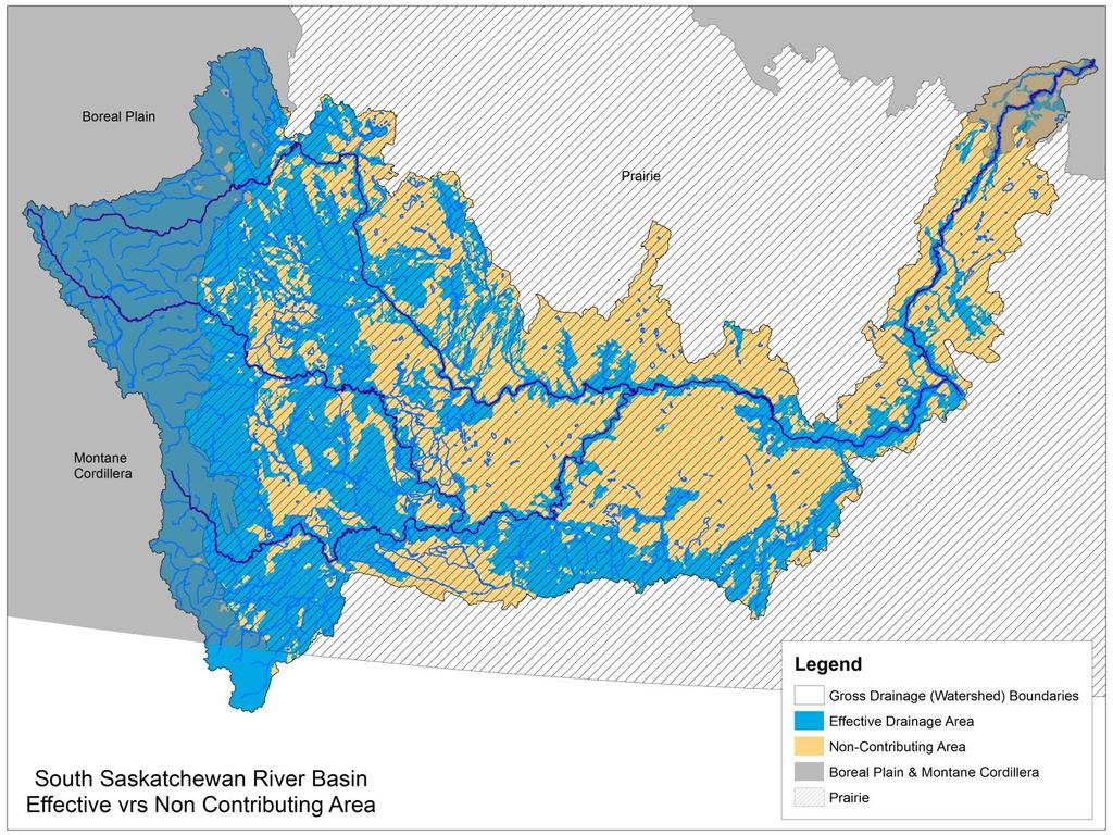
24 1.6 The Watershed A prominent characteristic of prairie drainage systems is the phenomenon of internal drainage. In essence, the downward movement or infiltration of surface water into the interstitial pore spaces of soil and bedrock combined with low topographical gradients, and relatively low levels of yearround precipitation results in disorganized surface hydrological systems overlying significantly developed groundwater aquifers. Due to a relatively recent history of extensive glaciation, most of the Prairies consist of a landscape entailing low topographic gradients combined with irregular or hummocky topography. Glacial sediments deposited from melting ice during the retreat of the glaciers some years ago has left vast stretches of moraine punctuated by gently rolling hills and isolated depressions. These depressions collect surface runoff during spring snowmelt and summer rainy seasons, producing small wetland systems called sloughs or prairie potholes. Except during periods of high rainfall, these surface waters often remain disconnected from adjacent water bodies, or drain into local wetlands, lakes, or sloughs which then remain isolated from larger surface water networks for many years, connecting only distantly through slow groundwater movement, if at all. Then, in periods of extremely high rainfall, the isolated internal drainage systems may finally contribute flow to larger systems in the form of streams, rivers, or large flooded areas. Consequently, there is a significant difference between the gross and the effective drainage area for larger river systems within the prairie region. The gross drainage area is essentially the total potential area that may contribute runoff to a main channel (stream or river) during extremely wet conditions, and is determined based solely on topography according to drainage divides (the height of land between adjoining watersheds). This area is also commonly referred to as the watershed, the boundaries of which are determined by the drainage divides, and which is conceptually considered to be the entire land base in which human activities may directly affect water quality or quantity. The gross drainage area, or total potential drainage area, can then be divided further into the areas which are expected to contribute runoff to major stream and river channels under average conditions (defined as the contributing area during a flood with a return period of two years) and those areas which are typically non-contributing (and therefore contribute runoff to local, or internal drainage systems (PFRA, 1983). In reality, the contributing and non-contributing areas will change according to current surface and groundwater storage and the amount and type of precipitation during each and every precipitation Page 28
25 or runoff event, regardless of any other influential factors such as soil and bedrock composition, ambient temperatures, evaporation rates, vegetation cover, and many others. However, the impracticality of determining a contributing area for each and every event when applying multiyear hydrological analysis has resulted in a need for some standardized set of accepted wet and dry drainage area delineations. As a result, such a standardized model of contributing and non-contributing (gross and effective) drainage area was determined for most watersheds in the Central Canada Prairie region (Alberta, Saskatchewan, and Manitoba) by the Prairie Farm Rehabilitation Association during a watershed delineation project conducted in the 1970s and published in a 1978 report (PFRA, 1983). Since the initial project, minor changes have been made to the linework depicting the delineations but essentially, most of the gross and effective areas remain the same and are used quite widely by both provincial and federal agencies today. Gross drainage areas were determined primarily by topography, combined other physiographic factors such as topographic slope, drainage pattern development, and depressional storage. Effective drainage area delineations, however, also included case by case visual assessments. A depression which did not overflow or spill into adjacent drainage areas (internally draining portions of the watershed) 50% of the time (for more than 1 out of every 2 years) was excluded from the effective drainage area of the basin. Similarly, drainage areas which not did contribute surface flow during extremely high runoff conditions ( wet years) were also excluded from the gross drainage area of the basin. Further details on how drainage areas were delineated by the Prairie Farm Rehabilitation Association can be found in the Hydrology Report #104, published in 1983 (PFRA, 1983). Page 29
26 I.6.i South Saskatchewan River Gross drainage areas for the major watersheds of the prairies were further delineated into sub basins by the PFRA Watershed Project according to a proposed system of hydrometric (flow measurement) gauging stations. These sub basins effectively divided the gross drainage area for all the major prairie river systems according to smaller sub-drainage areas within the larger drainage systems (such as creeks, streams, and other ephemeral surface systems) or by dividing the system mainstem into portions of river between gauging station locations. This was done in order to simplify the calculation of total drainage area for each hydrometric (flow) measurement gauge. In essence, each sub basins represents the tributary area for a specific gauging station. According to the gross drainage areas delineated by the PFRA project, there are approximately 520 sub basins within the South Saskatchewan River Basin, comprising a total gross drainage area of km², including the tributaries of the Bow, Oldman, and Red Deer Rivers at km², km², and km² respectively, and with the rest of the basin downstream from the confluence (the South Saskatchewan River) at km². Page 30
, then a letter B (for the Bow River), followed by a second letter according to its position")
27 Each gross drainage area is numbered according to its position within the larger basins associated with each major tributary. For example, all the sub basins of the Bow River begin with the number 05 (for Saskatchewan River System), then a letter B (for the Bow River), followed by a second letter according to its position in the watershed (generally from upstream to downstream, sub basins are named from A to Z), and then finally a number associated with the gauging station for which it represents the tributary area. For example, the sub basin 05BA is located at the upstream-most area of the Bow River, and is comprised of sub basins 05BA001 to 05BA011. Page 31
28 Page 32
29 Similarly, sub-basins of the Red Deer River are identified by the letter C, the Oldman River system by the letter A, and the South Saskatchewan River by the letter H. I.6.ii Effective Drainage Area: South Saskatchewan River As discussed previously, the effective drainage area (contributing area) of the South Saskatchewan River varies considerably across the prairies compared to the other physiographic regions of the South Saskatchewan River Basin. For example, in the Boreal Plains Ecozone, approximately 83% of the basin is contributing, compared to the Montane Cordillera at almost 99%, and the Prairie region where only 47% of the land base contributes surface water to the major river channels during a 1 in 2 year flood event. In the Montane Cordillera, with shallow soils, plenty of snowfall, and steep topography, almost the entire basin contributes runoff to the major drainage systems through a multitude of creeks, streams, through-flow lakes, and rivers. In stark contrast, about 53% of the South Saskatchewan River Basin in the Prairie Ecozone contributes no surface flow under average or normal conditions. The non-contributing drainage areas are located in the central and eastern portions of the basin. Some of these areas have well developed internally draining networks that terminate in a large wetland system or lake. Other areas include large portions of land with very poorly developed drainage networks that result in ephemeral (seasonal or temporary) streams and sloughs. Many non-contributing areas may in fact contribute runoff during extremely wet conditions. In addition to these internal drainage systems, sloughs and wetlands in the effective drainage area also store surface runoff generated by snow melt and summer rainfall, slowing infiltration into larger rivers and lakes and reducing the incidence and volume of floods during wet periods. Page 33
30 Page 34
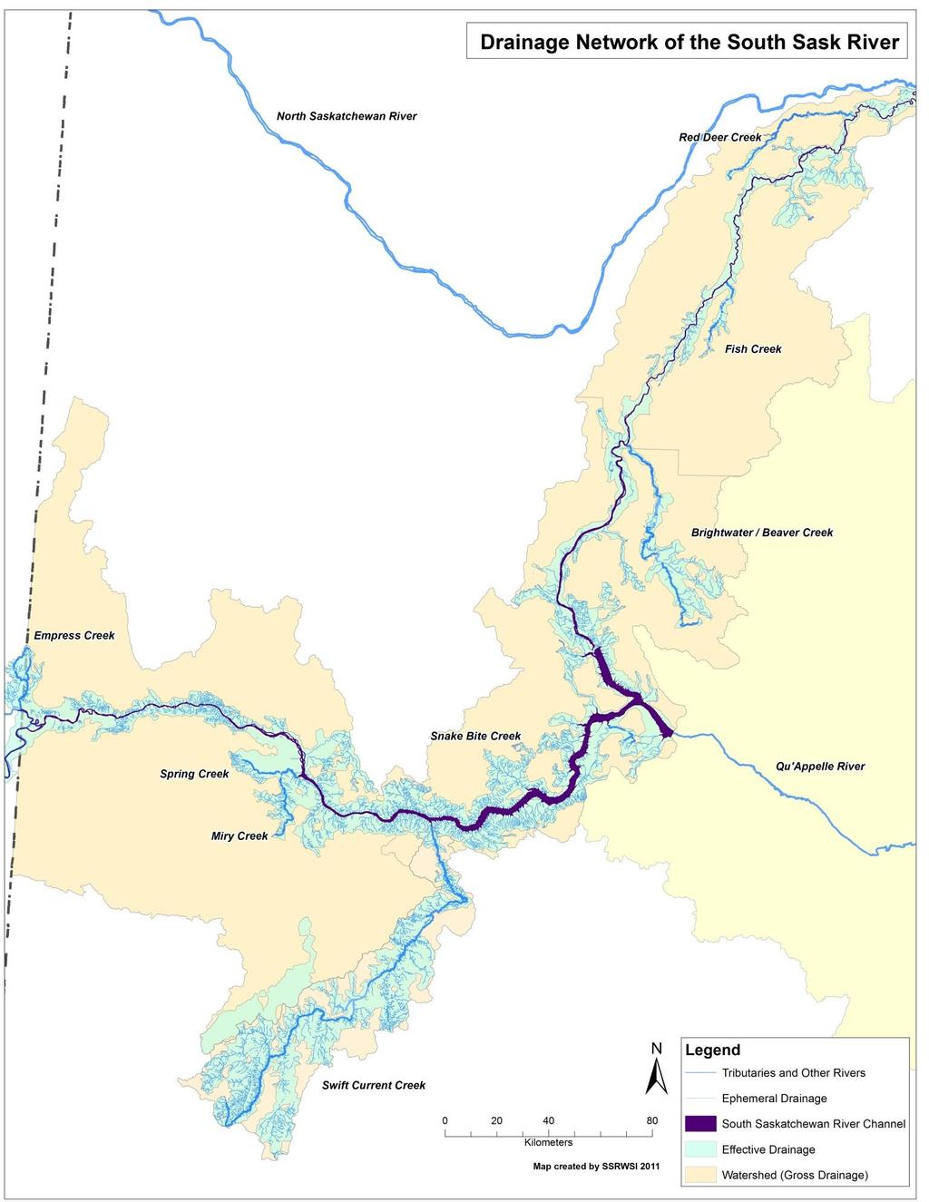
31 I.7 Hydrology of the South Saskatchewan River There is little in the natural environment, economy, and society of Saskatchewan that is not intimately tied to and sustained by the flow and storage of water. Nowhere else in Canada does the lack of excess of water cause such widespread concern, nor are there many Canadian environments subject to greater seasonal change in precipitation and surface-water storage. (Pomeroy, de Boer, and Martz, 2005) The Bow, Oldman, and Red Deer Rivers all have their headwaters in the Rocky Mountains of southern Alberta, within the Montane Cordillera Ecoregion. While spring runoff from snow melt on the prairies does contribute some flow to the downstream regions of the South Saskatchewan River, the hydrology of its tributaries are dominated by spring and summer snowmelt in the mountains. Even downstream, the relatively small contributing area in the eastern portions of Alberta and for most of the basin in Saskatchewan suggests that little surface runoff actually makes it into the river mainstem from the basin itself. However, a significant amount of groundwater flow sustains the river in the winter in both the prairies and mountainous regions, of which the contribution to total river flow is much more difficult to quantify. Within Saskatchewan, the only significant tributary is Swift Current Creek, which enters the river upstream from Gardiner Dam at the western end of Lake Diefenbaker. Swift Current Creek contributes a limited amount of flow to the river itself, however, estimated at about 1% of total river flow (Pomeroy, de Boer, Martz, 2005). Other notable tributaries in the Saskatchewan portion of the basin include Empress Creek, Spring and Miry Creek, Richardson Creek, Snake Bite Creek, Brightwater / Beaver Creek, Fish Creek, and Red Deer Creek, however these contribute a relatively small amount of flow, most of which is contributed during the spring and summer months. Page 35
32 Page 36
33 I.7.i Natural Flow Hydrology (Upstream of Gardiner Dam) Average discharge (flow) in the South Saskatchewan River is lowest during the winter months (December, January, and February), during which there is a significant amount of continuous ice cover. During spring freshet in March and April, flow is highest in the tributaries which receive snow melt from the Rocky Mountains. This surge in high surface flow takes some time to travel downstream, resulting in a peak flow period around June in the Saskatchewan portion of the river, upstream from Gardiner Dam. In the portions of the river downstream from the confluence of the Red Deer and South Saskatchewan Rivers, there is often a secondary peak in the early spring as well. This smaller peak is a result of local snow melt, which occurs in late March or in April and often continues into early May. The natural cycle of flow in the South Saskatchewan River can be seen in the hydrograph of flows recorded before the creation of Lake Diefenbaker and the Gardiner Dam. For example in 1963 at Lemsford Ferry and the City of Saskatoon: Page 37

34 I.7.ii Effect of Gardiner Dam on River Hydrology The construction of the Gardiner Dam and the creation of Lake Diefenbaker in the 1960s significantly changed the hydrological cycle of the South Saskatchewan River downstream from the dam. Gardiner Dam was constructed to produce hydroelectricity to supplement the coal generated electricity from the Queen Elizabeth Power Plant in Saskatoon. During the winter months, electricity demand is the highest due to the need for heating and light generation when days are at their shortest and coldest of the year. As a result, water release from the Gardiner Dam actually increases in the winter months, artificially raising the hydrograph for the river downstream. This results in a peak flow period usually in January or February. In the summer, a second peak flow period occurs downstream of the dam as upstream flow increases and water is released once the reservoir is at full or near-full capacity, in order to prevent dam breaching. Page 38
35 Figure 5: The monthly mean discharge regimes of several rivers in Saskatchewan (The North Saskatchewan, South Saskatchewan, Qu Appelle, Battle, and Churchill Rivers). Taken from Pomeroy, de Boer, and Martz, 2005, figure 4. The impact of Gardiner Dam on the flow regime downstream from the dam can be clearly seen by comparing the post-dam hydrographs from the flow gauging stations located at Lemsford Ferry and the City of Saskatoon. The Lemsford Ferry gauging station is located just downstream from the confluence of the Red Deer River and the South Saskatchewan River, but upstream from Lake Diefenbaker, and therefore is unaffected by the reservoir or Gardiner Dam. Page 39
36 Page 40
3.0 THE NORTH SASKATCHEWAN IN ALBERTA
 3.0 THE NORTH SASKATCHEWAN IN ALBERTA 3.1 WATERSHED OVERVIEW Wherever you are on earth, you are in a watershed. Most of the rain and snow falling outside your window will eventually find its way to a local
Region 1 Piney Woods
 Region 1 Piney Woods Piney Woods 1. This ecoregion is found in East Texas. 2. Climate: average annual rainfall of 36 to 50 inches is fairly uniformly distributed throughout the year, and humidity and temperatures
What Is An Ecoregion?
 Ecoregions of Texas What Is An Ecoregion? Ecoregion a major ecosystem with distinctive geography, characteristic plants and animals, and ecosystems that receives uniform solar radiation and moisture Sometimes
2.1 Physical and Biological Description Matabitchuan River Watershed
 2.1 Physical and Biological Description Watershed 2.1.1 Physical Description The system watershed has a total area of about 933 km 2 and is a tributary system to Lake Temiskaming and the Ottawa River Drainage
Geoscape Toronto The Oak Ridges Moraine Activity 2 - Page 1 of 10 Information Bulletin
 About 13,000 years ago as the Laurentide Ice Sheet melted, glacial meltwater accumulated between the ice sheet and the Niagara Escarpment. This formed a lake basin into which gravel and sand were deposited.
SECTION 3 GENERAL DESCRIPTION OF THE RIVER BASIN
 SECTION 3 GENERAL DESCRIPTION OF THE RIVER BASIN SECTION 3 GENERAL DESCRIPTION OF THE RIVER BASIN River basin description. A general description of the river basin or subbasin, as appropriate, in which
Seager Wheeler Lake. Representative Area. -- Concept Management Plan --
 Seager Wheeler Lake Representative Area -- Concept Management Plan -- Saskatchewan Environment and Resource Management January, 1999 Saskatchewan s Representative Areas Network Program The Government of
Mark West Creek Flow Study Report
 Mark West Creek Flow Study Report Biology and Geology of Mark West Creek The headwaters of Mark West Creek are located in the Mayacamas Mountain range, which border Napa and Sonoma County, where it then
Jan Lake Representative Area -- Concept Management Plan --
 Jan Lake Representative Area -- Concept Management Plan -- Saskatchewan Environment and Resource Management December, 1999 Saskatchewan s Representative Areas Network Program The government of Saskatchewan,
Level IV Ecoregions of the Northeast Glacial Lakes Watershed Project Area
 Level IV Ecoregions of the Northeast Glacial Lakes Watershed Project Area Ecoregions are areas having similar ecosystems and environmental resources including geology, physiography, vegetation, climate,
INTRODUCTION 250,000
 INTRODUCTION The United States of America has over 250,000 rivers, with a total of about 3,500,000 miles of rivers. The main stems of 38 rivers in the United States are at least 500 miles (800 km) long.
Colorado Life Zone Scavenger Hunt
 Colorado Life Zone Scavenger Hunt Below are worksheets created for all the habitats or life zones. They were designed with the intention of breaking the class up into small groups, and having students
The Geological Pacific Northwest. Wednesday February 6, 2012 Pacific Northwest History Mr. Rice
 The Geological Pacific Northwest Wednesday February 6, 2012 Pacific Northwest History Mr. Rice 1 Free Response #2 Please do not simply list the items for this response. Full sentences!!! Minimum of 3-5
Hydrology Input for West Souris River IWMP
 Hydrology Input for West Souris River IWMP Prepared by: Mark Lee Manitoba Water Stewardship 1 1 1 Overall view of: drainage area watershed characteristics gauging stations meteorological stations Runoff
II. THE BOULDER CREEK DRAINAGE BASIN
 II. THE BOULDER CREEK DRAINAGE BASIN This section provides an overview of the watersheds and flood hazards associated with Boulder Creek and South Boulder Creek including descriptions of the drainage basins,
Mackinnon Esker Ecological Reserve Draft - Management Plan
 Mackinnon Esker Ecological Reserve Draft - Management Plan May 2011 Photo Credit: This document replaces the direction provided in the Carp Lake Provincial Park and Protected Area and Mackinnon Esker Ecological
2.0 PARK VISION AND ROLES
 2.0 PARK VISION AND ROLES 2.1 Significance in the Protected Area System Marble Range and Edge Hills provincial parks protect 6.8% of the Pavillion Ranges Ecosection, which is located in the Southern Interior
Wallace Lake Provincial Park. Management Plan
 Wallace Lake Provincial Park Management Plan 2 Wallace Lake Provincial Park Table of Contents 1. Introduction... 3 2. Park History... 3 3. Park Attributes... 4 3.1 Natural... 4 3.2 Recreational... 4 4.
LITTLE LOST MAN CREEK (LLM) (formerly USGS Gaging Station No )
 (formerly USGS Gaging Station No )") LITTLE LOST MAN CREEK (LLM) (formerly USGS Gaging Station No. 11482468) LOCATION: In Redwood National and State Park approximately 0.8 miles upstream from confluence with Prairie Creek and 3.2 miles northeast
LITTLE LOST MAN CREEK (LLM) (formerly USGS Gaging Station No. 11482468) LOCATION: In Redwood National and State Park approximately 0.8 miles upstream from confluence with Prairie Creek and 3.2 miles northeast
2.0 Physical Characteristics
 _ 2.0 Physical Characteristics 2.1 Existing Land Use for the Project The site is comprised of approximately 114 acres bounded by Highway 101 to the north, the existing town of Los Alamos to the east, State
Chapter 2: El Dorado County Characteristics and Demographics
 Chapter 2: El Dorado County Characteristics and Demographics 2.1 Geographic Area and Demographics El Dorado County comprises 1,805 square miles with over half of the area in the Eldorado National Forest
FINGER-TATUK PROVINCIAL PARK
 FINGER-TATUK PROVINCIAL PARK PURPOSE STATEMENT AND ZONING PLAN March 2003 FINGER-TATUK PROVINCIAL PARK Purpose Statement and Zoning Plan Finger-Tatuk Provincial Park is 17,151 ha in size. It includes the
Wallace Lake Provincial Park. Draft Management Plan
 Wallace Lake Provincial Park Draft Management Plan Wallace Lake Provincial Park Draft Management Plan Table of Contents 1. Introduction... 3 2. Park History... 3 3. Park Attributes... 4 3.1 Natural...
EXPLORING BIOMES IN GORONGOSA NATIONAL PARK
 EXPLORING BIOMES IN GORONGOSA NATIONAL PARK ABOUT THIS WORKSHEET This worksheet complements the Click and Learn Gorongosa National Park Interactive Map (http://www.hhmi.org/biointeractive/gorongosa-national-park-interactive-map),
TO THE WORLD HERITAGE LIST. Convention concerning the Protection of the World Cultural and Natural Heritage
 NOMINATION TO THE WORLD HERITAGE LIST Convention concerning the Protection of the World Cultural and Natural Heritage Name I CANADIAN ROCKIES Identification No, 304 Date received by WH Secretariat, 23.12.83
Marchand Provincial Park. Management Plan
 Marchand Provincial Park Management Plan 2 Marchand Provincial Park Table of Contents 1. Introduction... 3 2. Park History... 3 3. Park Attributes... 4 3.1 Natural... 4 3.2 Recreational... 4 3.3 Additional
Chapter 14. The Physical Geography of Russia
 Chapter 14 The Physical Geography of Russia Chapter Objectives Identify the physical features and natural resources of Russia. Discuss the effects of Russia s climate and vegetation on life in the region.
Section 2 North Slope Ecoregions and Climate Scenarios
 Section 2 North Slope Ecoregions and Climate Scenarios North Slope Ecoregions The geographic/ecological scope of the workshop will be freshwater and terrestrial systems of the North Slope of Alaska, with
Pasquia-Porcupine. Representative Areas. -- Concept Management Plan --
 Pasquia-Porcupine Representative Areas -- Concept Management Plan -- Saskatchewan Environment June, 2004 Pasquia/Porcupine Integrated Forest Land Use Plan The Pasquia/Porcupine Integrated Forest Land Use
ALBERTA S GRASSLANDS IN CONTEXT
 ALBERTA S GRASSLANDS IN CONTEXT GLOBAL GRASSLANDS 1 Temperate grasslands, located north of the Tropic of Cancer and south of the Tropic of Capricorn, are one of the world s great terrestrial biomes 2.
Pinawa Provincial Park. Draft Management Plan
 Pinawa Provincial Park Draft Management Plan Pinawa Provincial Park Draft Management Plan Table of Contents 1. Introduction... 3 2. Park History... 3 3. Park Attributes... 4 3.1 Natural... 4 3.2 Recreational...
APPENDIX. Alberta Land Stewardship Act AMENDMENTS TO THE SOUTH SASKATCHEWAN REGIONAL PLAN
 APPENDIX Alberta Land Stewardship Act AMENDMENTS TO THE SOUTH SASKATCHEWAN REGIONAL PLAN 1 All references to Alberta Environment and Sustainable Resource Development, Environment and Sustainable Resource
South Atikaki Provincial Park. Draft Management Plan
 South Atikaki Provincial Park Draft Management Plan South Atikaki Provincial Park Draft Management Plan Table of Contents 1. Introduction... 3 2. Park History... 3 3. Park Attributes... 3 3.1 Natural...
GEOGRAPHY AND HISTORY
 GEOGRAPHY AND HISTORY YEAR 1, PART 1 www.vicensvives.es Contents 01 Our planet Earth 02 The representation of the Earth: maps 03 The Earth s relief 04 Rivers and seas 05 Weather and climate 06 Climates
Hudson Bay Lowlands Proposed Protected Areas
 Hudson Bay Lowlands Proposed Protected Areas Hudson Bay Lowlands Proposed Protected Areas The Protected Areas Initiative has identified portions of the Hudson Bay Lowlands region that have significant
CRAZY HORSE TRAIL GUIDE
 CRAZY HORSE TRAIL GUIDE Abridged Version: July 2016 This is a short form of our interpretive trail guide for the Crazy Horse Trail. The full version of the guide has a more detailed description of the
1. Landforms. The Boreal Shield. Location The Boreal Shield can be found from Alberta to Newfoundland, between the Taiga Shield and the Boreal Plains.
 The Boreal Shield Location The Boreal Shield can be found from Alberta to Newfoundland, between the Taiga Shield and the Boreal Plains. 1. Landforms Rolling hills Exposed bedrock Evidence of glacial weathering
Role of the Protected Area
 Role of the Protected Area Provincial and Regional Context Height of the Rockies and Elk Lakes provincial parks lie in southeastern British Columbia in the Rocky Mountains, about 85 km southwest of Calgary,
Whitemouth Falls Provincial Park. Draft Management Plan
 Whitemouth Falls Provincial Park Draft Management Plan Whitemouth Falls Provincial Park Draft Management Plan Table of Contents 1. Introduction... 3 2. Park History... 3 3. Park Attributes... 4 3.1 Natural...
Nakina Moraine Provincial Park. Interim Management Statement. Ontario. Ministry of Natural Resources
 Nakina Moraine Provincial Park Interim Management Statement Ontario Ministry of Natural Resources 1999, Queen's Printer for Ontario Printed in Ontario, Canada Additional copies of this publication can
Crete Study Site Description
 Crete Study Site Description 1. Location Crete (the largest island of Greece) is located in the south part of Greece covering an area of 8.335 km 2 or 6.3% of the Greek territory, including the surrounding
Hydrology of Yemen. Dr. Abdulla Noaman
 Hydrology of Yemen Dr. Abdulla Noaman INTRODUCTION Location and General Topography Yemen is located on the south of the Arabian Peninsula, between latitude 12 and 20 north and longitude 41 and 54east,
HIGH COUNTRY L-BAR RANCH
 HIGH COUNTRY L-BAR RANCH Sandoval and mckinley counties N e w m e x i c o Jim Haworth, Ranch Team Lead Broker ~ 505-235-5236 3613 NMSR 528 NW, Ste. H, Albuquerque, NM 87114 505-792-3713 www.wwrealty.com
Physical Regions of the U.S.
 Physical Regions of the U.S. Quickly use this map to label the map on your paper Pacific Coast The coast from southern California to Alaska The region of the Pacific Northwest has a long history that was
Recreation in the Battle River Basin: Overview. John Thompson, Watrecon Consulting
 Recreation in the Battle River Basin: Overview John Thompson, Watrecon Consulting Recreation Rates for Alberta & Battle Basin Households 1996 2004 Battle Basin Alberta Battle Basin Alberta Bird Watching
4. Hydrology of the Olentangy River Watershed
 4. Hydrology of the Olentangy River Watershed The Hydrologic Cycle Water on Planet Earth is dynamic constantly being recycled from the land to the atmosphere to the ocean. Rivers and streams are just a
HYDROLOGY OF GLACIAL LAKES, FORT SISSETON AREA
 PROC. S.D. ACAD. SCI., VOL. 77 (1998) 59 HYDROLOGY OF GLACIAL LAKES, FORT SISSETON AREA Perry H. Rahn Department of Geology & Geological Engineering South Dakota School of Mines and Technology Rapid City,
Glaciers and Glaciation Earth - Chapter 18 Stan Hatfield Southwestern Illinois College
 Glaciers and Glaciation Earth - Chapter 18 Stan Hatfield Southwestern Illinois College Glaciers Glaciers are parts of two basic cycles: 1. Hydrologic cycle 2. Rock cycle A glacier is a thick mass of ice
Glaciers Earth 9th Edition Chapter 18 Mass wasting: summary in haiku form Glaciers Glaciers Glaciers Glaciers Formation of glacial ice
 1 2 3 4 5 6 7 8 9 10 11 12 13 14 15 Earth 9 th Edition Chapter 18 Mass wasting: summary in haiku form Ten thousand years thence big glaciers began to melt - called "global warming." are parts of two basic
KANANASKIS COUNTRY PROVINCIAL RECREATION AREAS MANAGEMENT PLAN DRAFT TERMS OF REFERENCE - November 20, 2007
 KANANASKIS COUNTRY PROVINCIAL RECREATION AREAS MANAGEMENT PLAN DRAFT TERMS OF REFERENCE - November 20, 2007 BACKGROUND There are 42 Provincial Recreation Areas (PRAs) within Kananaskis Country located
Birch Point Provincial Park. Management Plan
 Birch Point Provincial Park Management Plan 2 Birch Point Provincial Park Table of Contents 1. Introduction... 3 2. Park History... 3 3. Park Attributes... 4 3.1 Natural... 4 3.2 Recreational... 4 4. Park
Just how big is Africa?
 The United States China India The United Kingdom Portugal Spain France Belgium Germany The Netherlands Switzerland Italy Eastern Europe Japan 11.7 million sq. miles Just how big is Africa? Chapter 18 Section
Brain Wrinkles. Africa: The impact of location, climate, & physical characteristics on where people live, the type of work they do, & how they travel
 Africa: The impact of location, climate, & physical characteristics on where people live, the type of work they do, & how they travel STANDARDS: SS7G3 The student will explain the impact of location, climate,
The Role of Glaciers in the Hydrologic Regime of the Nepal Himalaya. Donald Alford Richard Armstrong NSIDC Adina Racoviteanu NSIDC
 The Role of Glaciers in the Hydrologic Regime of the Nepal Himalaya Donald Alford Richard Armstrong NSIDC Adina Racoviteanu NSIDC Outline of the talk Study area and data bases Area altitude distributed
READING QUESTIONS: Glaciers GEOL /WI 60 pts. a. Alpine Ice from larger ice masses flowing through a valley to the ocean
 READING QUESTIONS: Glaciers GEOL 131 18/WI 60 pts NAME DUE: Tuesday, March 13 Glaciers: A Part of Two Basic Cycles (p. 192-195) 1. Match each type of glacier to its description: (2 pts) a. Alpine Ice from
Friday, November 10, 2017
 Friday, November 10, 2017 Andes and Midlatitude Countries Objective: Summarize the main physical features and regions of the Southern Cone. Identify and locate the urban centers and understand the pattern
ENVIRONMENT Environmental Service PRKLND REION, Red Deer F1 F F1 L1 F1 L1 M1 F4 F1 F2 F1 F2 L3 L1 F2 L1 L1 Map 2 Dillberry Lake Provincial Park Projec
 ENVIRONMENT Environmental Service PRKLND REION, Red Deer 67 66 68 69 65 64a,b 63 82 70 77 71 78 72 73 74 76 75 40a 40b 41 42 46 60 61 59 58 83 90 89 39 43 38 44 37 45 47 79 80 81 49 50 51 52 48 53 54 55
Intermediate report. Letter of agreement FAO - GCB/RAB/013/ITA
 Treated waste water for sustainable production of valuable biomass, soil and water quality improvement and combating desertification in Algeria and Tunisia Letter of agreement FAO - GCB/RAB/013/ITA Intermediate
Pembina Valley Provincial Park. Draft Management Plan
 Pembina Valley Provincial Park Draft Management Plan 2 Pembina Valley Provincial Park Table of Contents 1. Introduction... 3 2. Park History... 3 3. Park Attributes... 3 3.1 Natural... 3 3.2 Recreational...
The Small Swale Resource Overview
 The Small Swale Resource Overview Prepared for: City of Saskatoon Community Services Department City Planning Branch Prepared by: Stantec Consulting Ltd. #100 75 24 th Street East Saskatoon, Saskatchewan
2.1 What is the climate like?
 José Medeiros This fact sheet allows you to see how varied the countryside is across Brazil. 2.1 What is the climate like? Most of Brazil is in the Southern Hemisphere, where the seasons are the opposite
4/28/17. Clicker Question. Clicker Question. #37 Floods IV (Case Histories-Mississippi River Flood, 1993; Red River of North Flood, 1997)
") GEOL 118 Final Exam Format similar to exams 1 and 2 Covers Lectures #27 40 (Global Climate Change I - Meteorite Impacts III) Web Exercise #6 - Due by 1 pm, Monday (5/1) 8:00 AM, Thursday, May 11 th Location
GEOL 118 Final Exam Format similar to exams 1 and 2 Covers Lectures #27 40 (Global Climate Change I - Meteorite Impacts III) Web Exercise #6 - Due by 1 pm, Monday (5/1) 8:00 AM, Thursday, May 11 th Location
X. WHATCOM CREEK SMA. X.1 Watershed Analysis. X.1.1 Landscape Setting
 X. WHATCOM CREEK SMA Summary: The entire length of Whatcom Creek is located within the City of Bellingham. SMA jurisdiction associated with this creek is approximately 300 acres. Land use is dominated
Introduction. Implementation of the Village of Capac Master Plan
 Implementation of the Village of Capac Master Plan Introduction The key to a well-planned community is the actual day-to-day use of planning documents, like this Master Plan. Because this plan is to be
Sasagiu Rapids Provincial Park. Draft Management Plan
 Sasagiu Rapids Provincial Park Draft Management Plan 2 Sasagiu Rapids Provincial Park Table of Contents 1. Introduction... 3 2. Background and Park Attributes... 3 2.1 Park History.... 3 2.2 Natural Features...
1.4 Understand how moving ice acts as an agent of erosion and deposition. (Chap. 2)
") 1.4 Understand how moving ice acts as an agent of erosion and deposition. (Chap. 2) There are two types of glaciation. Alpine Glaciation Continental Glaciation Distinguish between the terms alpine glaciation
1.4 Understand how moving ice acts as an agent of erosion and deposition. (Chap. 2) There are two types of glaciation. Alpine Glaciation Continental Glaciation Distinguish between the terms alpine glaciation
Mackinnon Esker Ecological Reserve. Management Plan
 Mackinnon Esker Ecological Reserve Management Plan March 2017 Cover Page Photo Credit: Rob Bell This document replaces the direction provided in the Carp Lake Provincial Park and Protected Area and Mackinnon
glacier Little Ice Age continental glacier valley glacier ice cap glaciation firn glacial ice plastic flow basal slip Chapter 14
 Little Ice Age glacier valley glacier continental glacier ice cap glaciation firn glacial ice plastic flow basal slip glacial budget zone of accumulation zone of wastage glacial surge abrasion glacial
"ST. KLIMENT OHRIDSKI FACULTY OF GEOLOGY AND GEOGRAPHY
 SOFIA UNIVERSITY "ST. KLIMENT OHRIDSKI FACULTY OF GEOLOGY AND GEOGRAPHY APPLICATION OF THE MODEL "DRIVING FORCES PRESSURE STATE - RESPONSE FOR ASSESSMENT OF FLOOD RISK RADOSTINA BORISOVA DOCHEVA Bachelor
NOTICE OF INTENT MAPS WITH DESCRIPTIONS
 NOTICE OF INTENT MAPS WITH DESCRIPTIONS Location Map(s) to Accompany Notice of Intent The small corner map embedded in the lower left corner of the large map above shows the location of the three national
Monday, December 11, 2017
 Monday, December 11, 2017 Physical Geography of Russia Objective: complete Warm-Up, write outline notes and discuss the geography of Eastern Europe/mother Russia and view Geography Now: Belarus. География
Chapter 20. The Physical Geography of Africa South of the Sahara
 Chapter 20 The Physical Geography of Africa South of the Sahara Chapter Objectives Identify the major landforms, water systems, and natural resources of Africa south of the Sahara. Describe the relationship
Town of Oakfield Agricultural and Farmland Protection Plan
 SECTION III COMMUNITY OVERVIEW A. Regional Setting / Location The Town of Oakfield is located in the northwestern portion of Genesee County. Located west of New York's Finger Lakes, the Town is uniquely
Neso Lake. Classification: Landscape Description: Park Purpose: Recreation Park
 Neso Lake Classification: Recreation Park Landscape Description: This small recreation park provides access to Neso Lake and the Mistik Creek canoe route. It is located in the Churchill River Upland portion
Brinker Creek Ranch. Colorado - Routt County - Yampa
 Located at the base of the Flattops Range in the Steamboat/Vail corridor, Brinker Creek Ranch consists of 1,451 acres ideally suited for high country grazing and native grass hay production. Traditionally
PHYSICAL GEOGRAPHY GEOGRAPHY EARTH SYSTEMS COASTAL SYSTEMS FLUVIAL SYSTEMS
 PHYSICAL GEOGRAPHY EARTH SYSTEMS FLUVIAL SYSTEMS COASTAL SYSTEMS PHYSICAL GEOGRAPHY CORRIES / CIRQUES A Corrie or Cirque is the armchair shaped hollow that was the birthplace of a glacier. It has steep,
Massanutten Mountain Cluster
 Massanutten Mountain Cluster Signal Knob Catback Mountain Southern Massanutten Mountain Five areas of almost 49,000 acres on the Lee Ranger District compose the Massanutten Mountain Cluster of Mountain
RAY YENKANA Willowbrook Cr, Dawson Creek BC Canada $2,847,000
 1716 Willowbrook Cr, Dawson Creek BC Canada For SALE $2,847,000 This is a rare find, 32 townhomes in Dawson Creek, BC. Excellent investment in a single title multi family complex. Vendor has upgraded this
ANAGEMENT. LAN November, 1996
 M ANAGEMENT P LAN November, 1996 for Paul Lake Provincial Park Ministry of Environment, Lands and Parks BC Parks Department Paul Lake Provincial Park M ANAGEMENT P LAN Prepared by BC Parks Kamloops Area
Natural regions of Alberta
 Natural regions of Alberta Alberta is a big province. It has 6 natural regions. Can you find the regions on the map? Use the legend. Canadian Shield region W This map shows northeastern Alberta. Can you
47I THE LAS ANIMAS GLACIER.
 THE LAS ANIMAS GLACIER. ONE of the largest of the extinct glaciers of the Rocky Mountains was that which occupied the valley of the Las Animas river. This stream originates in the San Juan mountains in
Chapter 7 Geography and the Early Settlement of Egypt, Kush, and Canaan
 Chapter 7 Geography and the Early Settlement of Egypt, Kush, and Canaan How did geography affect early settlement in Egypt, Kush, and Canaan? Section 7.1 - Introduction RF/NASA//Corbis This satellite photograph
Summary of prescribed fires in Prince Albert National Park 2015
 Summary of prescribed fires in Prince Albert National Park 2015 Prince Albert National Park conducted four controlled fires in spring 2015, plus an additional fire in October. Fuel Management for Hazard
Specification for Grip blocking using Peat Dams
 Technical Guidance Note 1 Specification for Grip blocking using Peat Dams 1. Introduction Moorland drains (grips) have been dug across much of the Yorkshire upland peatlands. Many of these grips have become
There are actually six geographic sub-regions, three in both the uplands and the lowlands.
 6 Regions of AR Although Arkansas is most easily divided into two distinct geographical regions, the northwestern uplands and the southeastern lowlands, this description does not accurately portray the
Clearwater Lake Provincial Park. Draft Management Plan
 Clearwater Lake Provincial Park Draft Management Plan Clearwater Lake Provincial Park Draft Management Plan Table of Contents 1. Introduction... 3 2. Park History... 4 3. Park Attributes... 4 3.1 Location/Access...4
Match the names below with their locations on the map by writing the correct letter in the blank.
 P r e v i e w Match the names below with their locations on the map by writing the correct letter in the blank. Physical Features of Canada 60ºN 70ºN 80ºN A R C T I C O C E A N 130ºW 120ºW 110ºW 90ºW 70ºW
Bridge River Delta Park. Management Plan. Final Public Review Draft
 Bridge River Delta Park Management Plan Final Public Review Draft March 2016 Bridge River Delta Park Management Plan Approved by: Jeff Leahy Regional Director Thompson Cariboo Region BC Parks Date Brian
Chapter 16 Glaciers and Glaciations
 Chapter 16 Glaciers and Glaciations Name: Page 419-454 (2nd Ed.) ; Page 406-439 (1st Ed.) Part A: Anticipation Guide: Please read through these statements before reading and mark them as true or false.
2009 Clearwater Area Sheep
 2009 Clearwater Area Sheep Section Authors: Chiarastella Feder and Shevenell Webb Suggested Citation: Feder, C. and S. Webb. 2009. Clearwater Area Sheep. Pages 22 25. In: N. Webb and R. Anderson. Delegated
ORTHOLOGICAL MANAGEMENT OF HYDROLOGICAL RUNOFF BASINS OF THE PREFECTURE OF DRAMA (CURRENT SITUATION PROTECTIVE ACTIONS PERSPECTIVES)
") ORTHOLOGICAL MANAGEMENT OF HYDROLOGICAL RUNOFF BASINS OF THE PREFECTURE OF DRAMA (CURRENT SITUATION PROTECTIVE ACTIONS PERSPECTIVES) This paper presents the torrential environment of the torrents of the
ORTHOLOGICAL MANAGEMENT OF HYDROLOGICAL RUNOFF BASINS OF THE PREFECTURE OF DRAMA (CURRENT SITUATION PROTECTIVE ACTIONS PERSPECTIVES) This paper presents the torrential environment of the torrents of the
Did It. naturalists. Young. Moving and melting ice shaped many of Minnesota s land features. 30 Minnesota Conservation Volunteer
 Young naturalists by Mary Hoff Photography by Gary Alan Nelson T he Glacier Did It Moving and melting ice shaped many of Minnesota s land features. Shut your eyes. Imagine that it s a sunny summer day
c. 1 inch = 0.6 miles e. 1:100,000 f. 1:250,000 f. 1 inch = 4.0 miles
 High School Advance Geology Map Test 2014 Name Use the information on each map to provide the best answer to the questions. Fill in the bubble of the best answer on your answer sheet. Answer questions
B is for British Columbia. A is For Alberta
 C is for Canada A is For Alberta Alberta is one of the only provinces in Canada with 2 NHL teams. Edmonton, the capital of Alberta is the home of the West Edmonton Mall, which is the largest shopping mall
Recrystallization of snow to form LARGE. called FIRN: like packed snowballs. the weight of overlying firn and snow.
 Chapter 11 Glaciers BFRB P. 103-104, 104, 108, 117-120120 Process of Glacier Formation Snow does NOT melt in summer Recrystallization of snow to form LARGE crystals of ice (rough and granular) called
NORTH CASCADE SLACIER CLIMATE PROJECT Director: Dr. Mauri S. Pelto Department of Environmental Science Nichols College, Dudley MA 01571
 NORTH CASCADE SLACIER CLIMATE PROJECT Director: Dr. Mauri S. Pelto Department of Environmental Science Nichols College, Dudley MA 01571 INTRODUCTION The North Cascade Glacier-Climate Project was founded
Geography: Unit 2. Map. Rivers. Major Physical Features. Slide 1. Slide 2. Slide 3. Slide 4. North America United States and Canada.
 Mississippi River Slide 1 Slide 2 Slide 3 Slide 4 Geography: Unit 2 North America United States Map Major Physical Features Mountain Ranges Brooks Range Mackenzie Mountains Coast Mountains Cascades Sierra
GLACIATION. The Last Ice Age (see Chapter 12) and. Pleistocene Ice Cap. Glacial Dynamics 10/2/2012. Laurentide Ice Sheet over NYS
 and. Pleistocene Ice Cap. Glacial Dynamics 10/2/2012. Laurentide Ice Sheet over NYS") GLACIATION and New York State Prof. Anthony Grande The Last Ice Age (see Chapter 1) The Pleistocene Epoch began 1.6 mya. During this time, climates grew colder. There were numerous ice ages starting 100,000000
GLACIATION and New York State Prof. Anthony Grande The Last Ice Age (see Chapter 1) The Pleistocene Epoch began 1.6 mya. During this time, climates grew colder. There were numerous ice ages starting 100,000000
Beaver Creek Provincial Park. Management Plan
 Beaver Creek Provincial Park Management Plan 2 Beaver Creek Provincial Park Table of Contents 1. Introduction... 3 2. Park History... 3 3. Park Attributes... 4 3.1 Natural... 4 3.2 Recreational... 4 4.
Latin America. Chapter 9 Physical Geography
 Latin America Chapter 9 Physical Geography Latin American Regions Middle America includes Mexico and the Central American countries The Caribbean Islands South America Mexico Landforms Sierra Madre Oriental