Dolwe island Jewel of Lake Victoria
|
|
|
- Coral Bell
- 5 years ago
- Views:
Transcription


1 Dolwe island Jewel of Lake Victoria
2 With the support of DEPARTMENT OF MUSEUMS AND MONUMENTS UGANDA DEPARTMENT OF MUSEUMS & MONUMENTS The Uganda Department of Museums and Monuments is mandated to protect, promote and present the cultural and natural heritage of Uganda through collection, conservation, study, and information dissemination. It is responsible for over 650 national sites, of which 56 sites are of rock art paintings, engravings, and gongs. The Department is based at the Uganda Museum, which was established in 1908 and is the oldest museum in East Africa. The Uganda Museum houses ethnographic, archaeological, palaeontological and historical as well as botanical artefacts, making it a national research hub. TARA - TRUST FOR AFRICAN ROCK ART TARA is a Nairobi-based, non-governmental organisation committed to recording the rich rock art heritage of the African continent, to making this information widely accessible and, to the extent possible, safeguarding those sites most threatened by humans and nature. To achieve its mission, TARA works closely with communities where rock art is found as well as with national and international heritage bodies including the UNESCO World Heritage Centre. THIS IS A TARA PUBLICATION - Photos David Coulson / TARA unless credited otherwise Text: David Coulson and Jackline Nyiracyiza Design & Layout: Richard Wachara ISBN TARA i


3 CONTENTS i. ii Partner Information Content Introduction Dolwe Rock Art Project 8 6. History & Development 8. Dolwe & The Cultural Landscape Archeology 14. Rock Gongs 16. Carved depressions/ Hollows 18. Pottery and Stone Age sites 21. Rock Art Conservation 23. Tourism 23. How to get there ii

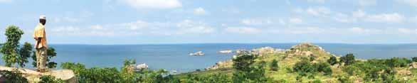
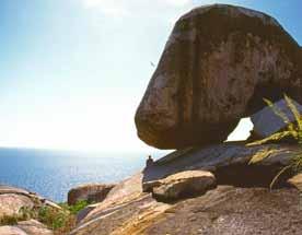
4 West side of the island looking north towards Golofa Introduction Dolwe island is one of Uganda s (and Lake Victoria s) best kept secrets, a beautiful island about 25 sq km, situated in Ugandan waters not far from the Kenyan border. It is characterized by the many granite rocks and boulders which rise like castles across the landscape, one gigantic boulder balanced on another, as if a giant had been playing with them. And hidden away inside these natural castles are messages and symbols from the past in the form of rock paintings, carvings and engravings and also gongs ( rock gongs ), left behind by unknown people long ago (one of the largest concentration of rock gongs in Africa), opening windows onto Dolwe s mysterious and enigmatic past. From these and other archaeological treasures we obtain glimpses of the many rich and diverse cultures that flourished here over the millennia. There is also another mysterious and remarkable artistic heritage from the past in the form of what archaeologists call ground (carved) depressions/hollows in the granite which abound here in their thousands. Typically these are found carved into large granite slabs or flattish boulders where the sculptors of long ago have sometimes managed to squeeze in as many as a hundred of these scoops as we like to call them into a slab that might only measure 5 meters by 6 meters, and each scoop might typically measure about 35 cm long by 25 cm wide and maybe 15 cm deep, and looking at them you reflect on the fact that carving any one of these might have 2

5 taken an ancient artist, because this is art, months to create one of them, and there must be at least 20,000 of them on this small island! Nowhere in Africa, and probably in the world, is there such an extraordinary concentration of these hollows/scoops. Their very numbers, as well as the fact that they are often found 15 meters up on the top of huge boulders almost impossible to reach, suggest a ritual/spiritual origin (motivation), rather than a functional one such as for grinding maize. The population of the island numbers around 10,000, we were told, at least half of which live in the town of Golofa facing onto a natural rocky harbour where one of the most important rock painting sites is also located. Meanwhile the rest of the inhabitants are scattered over a large area but are mainly in the northern part of the island. Most of the island is still wild and undeveloped and there are no roads or 4 wheel vehicles, the only motorized transport being Boda bodas who skilfully navigate the network of sandy paths that crisscross the island. Apart from subsistence farming the main local industry is fishing of which the main products are Nile perch and tilapia. Nile perch on this lake can exceed 80 kg and can measure up to two meters. Today fishing is what this island is all about, which is hardly surprising, and the fish means birds which are there in their thousands Standing on the southern shores of the islands you look out over Africa s biggest lake its blue waters punctuated here and there by little white sails and it s as if you were at the edge of an ocean. Bay at north of island seen from Kandege 3

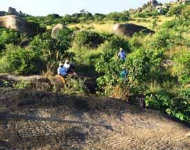
6 Rock formation near painting site on top of Munene island Dolwe Rock Art Project Dolwe Rock Art site is part of the six serial rock art sites in Eastern Uganda to be nominated to the World Heritage List. Submission was made to the World Heritage committee in 2015 but the file was referred due to lack of proper conservation/ management of sites, a danger to a World Heritage Site. For Dolwe in particular, UNESCO recommended a systematic documentation of the island, recording of all rock art (paintings, engravings, cupules, hollows and gongs) including all archaeological sites that could be on the island and need protection. In November 2015, a senior conservator (Jackline N. Besigye) was invited by the Trust for African Rock Art (TARA) to present a paper in Morocco-Agadir on rock art at risk in Uganda. The workshop in Agadir was aimed at safeguarding African rock art at risk. The presentations made by the Senior Conservator attracted members of the Prince Claus Fund (PCF) who then asked for collaboration towards the conservation of rock art sites in Dolwe. A project was then proposed and this was to be spear headed by TARA. The project was intended to extensively document all cultural heritage sites at Dolwe island for development of a tourism product that suits international standards. An extensive survey and documentation on Dolwe island was therefore conducted 4


7 Member of TARA team recording rock engravings near Singila and a number of rock paintings (12), gongs (13) including audio sounds, and engravings (8) were recorded through digital photography, sketching as well as coordinates of site locations. Some of the sites documented had been earlier recorded by previous scholars and researchers; however a number of new cultural heritage resources were also reported. Records from the documented sites indicate 4 new rock paintings, 10 rock gong sites and 6 rock engravings. To ensure proper management and conservation, the existing management plan was reviewed and is currently under implementation. Community sensitizations were conducted to ensure that the available cultural heritage resources with their values are known to the local community. Sensitization included workshops, production of awareness materials such, t-shirts, banners, stickers, and fliers were distributed to people around the island. This booklet is as a result of the Dolwe rock art project. It is anticipated that results from this project will market Dolwe island for both domestic and international visitors. The project is ongoing though constrained by inadequate resources due to the size of the island and the high concentration of heritage sites. Ground hollows on the rocks at Kandege (above) with detail of paintings bottom (right) 5
, the Basoga people never permanently settled on this island since")

8 Local members of an independent church group, Spirit of Israel, dancing with Singila rock art site in background History & Development Melted candle wax on one of the boulders at the Singila rock art site where church groups perform rituals Though Dolwe island is situated in the north eastern part of Lake Victoria (Busoga region), the Basoga people never permanently settled on this island since they had no culture of fishing. According to oral history, the first inhabitants of Dolwe island were the Bavuma people from Buvuma island in 1904 who were chased from Buvuma after they abused their King (Kabaka Daudi Chwa II (Buganda King). According to Bivens (2015), communities in different parts of the Lake basin resisted the move by British colonisers who forcefully removed them from their traditional areas to new areas without Tsetse Fly, as the sickness had already caused thousands of deaths. In Busoga region, this problem had begun in 1901, and by 1904 there was wide spread sleeping sickness which caused many neurological disorders. This act of relocation of communities caused people to abuse the King which is why they had to flee. For instance, about 2/3rds of the people who lived on the Island of Buvuma in Lake Victoria then died from sleeping sickness. So the remaining people relocated to Dolwe island while others continued to Mfangano island (home of the current Suba people). It is said that in the 1920s, there was an epidemic of sleeping sickness on Dolwe island and later, in 1954, this forced the majority of the inhabitants to evacuate. These interruptions to the continuous occupation of the island may have led to the loss of Dolwe s oral legends and thus the knowledge of who its earlier inhabitants may have been and how they lived. There are indications regarding the former existence of such legends and mythologies as evidenced by the contemporary use of ancient sites (caves and rock shelters) by independent church groups today. These groups recognize the power of certain sites which they believe are inhabited by powerful spirits which they then harness to perform their rituals. The legends that 6

 and Kandege site 2 (as named in the Museums and Monuments report, 2016) were reported by Hinchliffe and Neal in 1953 when searching for Mau Mau escapees from Kenya.")
9 once explained these beliefs have been lost but the practices persist to this day. Currently, the island is inhabited by diverse groups of people from different regions of the country and the neighbouring countries. Dolwe island is generally rich with cultural and natural heritage resources including rock art. A number of rock art sites have been documented at various times by different people. Bugire site 1 (Golofa) and Kandege site 2 (as named in the Museums and Monuments report, 2016) were reported by Hinchliffe and Neal in 1953 when searching for Mau Mau escapees from Kenya. The sites were then documented by the Museums and Antiquities curator, Merrick Posnansky, who visited Golofa site 1 in 1958 and made subsequent visits between 1959 and Excavations at Bugire 1 revealed Urewe, Entebbe and roulette potsherds that indicated different occupation episodes representing early, middle and later Iron Age. Since then Dolwe was listed on the national database that holds heritage sites of national and international status. Following several survey trips by TARA, in 2016, the Uganda Department of Museums and Monuments together (with TARA), conducted a systematic survey and recorded a total of 12 rock paintings, 13 gongs including audio sounds and 10 engraving sites. Surface collection at some of the sites visited, such as in Singila area, revealed a concentration of lithics, Urewe, Entebbe and roulette potsherds. A stone wall was also reported that indicated late settlements. In 1965 a wooden ladder was installed at Bugire 1 for easy access to the shelter. In 2013 this was transformed into a cemented ladder with rails. In the same year signage was installed on site and along paths in Bugiri, Namayingo and at Bwonda. At other island sites no development has taken place yet, but these will be under proper management. This follows the review of the 2012 Management Plan in 2016 that included a management committee with representatives coming from all 14 villages on the island. Signage on the mainland advertising Dolwe rock art sites Large painted lettering on boulder at Kandege advertising an independent church site 7

10 Museum team recording rock engravings near Singila Dolwe and the Cultural Landscape Dolwe island has been studied for many years but none of the previous scholars seem to have seen the island as a Cultural Landscape. The 2016 team does however recognize the island as a cultural landscape because of the cultural values, the belief systems that existed among our ancestors and the present communities living on this island. When you look at this landscape you can only imagine how nomadic huntergatherers accessed and interacted with this treasure house of culture and history, with its legacy of stones that offered good shelter, where some of these people painted and engraved for maybe thousands of years. Perhaps the island was a reliable one-stop centre for hunter-gatherer communities because the boulders provided shelter from the sun and rain as well as natural warmth in colder times. According to Anschutz et al. (2001), Landscapes are in essence synthetic with cultural systems structuring and organizing peoples interaction with the natural environment. Looking at the many cultural products on this island, including rock paintings and engravings, rock gongs, ground hollows, stone tools and pottery, to mention a few, it seems right to attribute these landscapes as a world of cultural products. It should also be noted that landscapes play a crucial role in the formation of identity at all levels (Cumming 2013). It is possible that Dolwe hunter-gatherers 8
.")
11 and agriculturalists perceived this island s landscape as enshrining knowledge of what happened in the past and recorded it in the rock art. Based on data collected from the island in the 1960s, there is cultural material from the Middle Stone Age and the Iron Age (Posnansky et al. 2005). This suggests that the last hunter-gatherers who inhabited the island may have been here before the Holocene (more than 11,000 years ago) at a time when the lake was either shallow or non-existent (Posnansky et al. 2005). The absence of Later Stone Age microlithic tools on the surface of the island might justify Posnansky s argument that hunter-gatherers could not have reached the island if the volumes of water were at all similar to the present, given that to our knowledge boat-making skills did not exist at that time. Fig. 2 shows the kind of lithic material that was collected from 6 sites on the island during the project. At some sites there were large quantities of these stones indicating that these may have been factory sites. However our search did not locate a source of quartz rock on the island from where these could have been brought. It is possible that the source could have been on one of the nearby islands such as Bavuma or Sese or in western Kenya where similar activities were practiced. Ground hollow site near Singila and a detail showing complex geometric engraving near Kandege

12 Rock Art of Dolwe As already explained the existence of rock art on Dolwe has been known for more than 50 years but it is only relatively recently that the full extent of this art is becoming known. What is interesting and unusual is the diversity of different styles and types of art indicating that the art was the product of a number of different cultures over time. Normally particular styles of art are associated with different geographical areas but here they are together and apparently mixed up, and many of them have not been recorded anywhere else. The main style/type of rock art associated with Eastern Uganda and Western Kenya is what we call Batwa (or Twa) art which can usually be identified because of its geometric imagery (typically, concentric circles and spirals). The same art is also found in north and north-western Kenya. Another name for the Ba-Twa (literally Twa people) is the Pygmies who are forest people. This appears to make sense given that not very long ago much of Uganda was part of the Central African Rain Forest, and much of western Kenya too. Recent research indicates that these geometric images were powerful symbols relating to their belief systems. Abstract rock painting site at Bukangawa 10

13 Dumbbell style paintings on roof of Bugiri Cave site near Golofa 11
 are either concentric circles or pairs of concentric circles linked by parallel lines giving the appearance of dumbbells.")

14 The most remarkable and important rock art on the island is at the main Bugire painting site which is situated beneath a massive flat boulder, weighing well over 100 tons, at the water s edge not far from Golofa town. Most of the paintings (mainly red but some red and white) are either concentric circles or pairs of concentric circles linked by parallel lines giving the appearance of dumbbells. These paintings may well have been the work of ancestral Twa. They are mostly about a meter long and are painted on the ceiling of the shelter which is roughly 1.5 m above the floor. It is the fact that the paintings are on the ceiling that has preserved them so well. On the bay (water) side of the shelter are a number of rock gongs, rocks with natural resonance which were used in ancient times for divining and communication. When David Coulson and Alec Campbell of TARA first recorded this site about 16 years ago they were shocked to find bright orange graffiti superimposed on some of the ancient symbols (see page 21, centre image). The local people were unaware of the immense importance of this ancient site on their doorstep, and many of them still are. During the 2016 project several remarkable new sites were recorded which are illustrated in this booklet, paintings and engravings which in TARA s experience are unique. The team was also able to rediscover two important painting sites which TARA had photographed 16 years ago but whose location had subsequently been lost. NB. WARNING.. Dolwe s modern rock art! A few years ago a group of modern artists and musicians from the UK visited Dolwe in order to look at the rock art and play the rock gongs. They made a short documentary film about their visit. While they were there some of them created fresh rock art which might be confusing to other visitors who come across it today. A sculptor in the UK group cut a large egg-shaped stone in half and carved concentric circles on each of the flat inner surfaces. Someone else carved the deep outline of a life size crocodile on a long, low rock and someone else carved a simple design on a flat rock that looked a bit like lizards presented as arrows. These must be seen as modern contributions. For more information on this please contact Rungwe Kingdon of the Pangolin Foundry (Uganda and UK). Two contemporary engravings made by a group of British artists who visited the island some years ago. 12


15 Main image: Engraving site, not far from Kandege, recorded for first time during the project. Inset: Complex geometric engraving at the same site 13


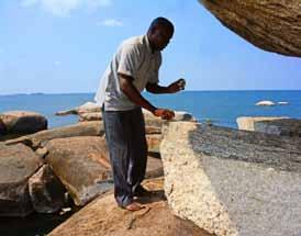
16 Rock Gongs Playing a rock gong behind Golofa Koppies situated on an adge between 2 huge boulders Sound is one of the senses that define a landscape. Although Dolwe is today occupied by about 10,000 people, most of them live only on the lake shore since the majority are fishermen. But a few who use the landscape for other purposes, attest that sometimes they can hear the sound of their ancestors through gongs, the noise of the wind and the mysterious sounds of waves crashing on the shores of the lake. As already mentioned, rock gongs are rocks with natural resonance which, when struck with a hammer stone produce a ringing sound that can sometimes be musical. Rock gongs occur in different parts of the world but are especially common in Africa. According to the information available these gongs were used in the past in order to communicate special messages, a bit like drums were used in different parts of Africa until recent times (e.g in Uganda). They were also used for divining purposes Painting site in an alcove next to the rock gong (above) 14


17 (evoking the spirits). What is unusual and special about the Dolwe gongs is how many of them occur in a relatively small area. Another interesting point is that in a number of instances they occur where there are rock paintings or where there are sacred sites. We can only guess the reasons for this proximity. Perhaps it could be a testament of visual art as a medium of mediating, divining and recounting as a means of fully experiencing profound human events (Taçon and Chippindale 1998). Playing a rock gong near Bukangawa. View of an important cave painting site above Bukangawa (see image on Contents page) 15

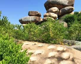
18 Carved Depressions/Hollows Dolwe hosts the greatest concentration of ground hollows, large carved depressions in the granite, also called grinding hollows, and erroneously called cupules, which are small cup-shaped depressions in the rock. TARA has recorded these hollows in several countries including Kenya and Tanganyika as well as in the Sahara. TARA also has images and information on other quite large concentrations of hollows in Cameroon and South Sudan, but nowhere are there as many as what we have recorded on Dolwe. Much more research is needed to determine the possible purpose of these mysterious depressions. In TARA s opinion they were probably made for spiritual reasons. This is the most likely explanation. Carved depressions/ground hollows near Singila, with Munene island beyond

")
19 Carved hollows near Singila (above) and at Golofa (below) 17
 and Ashley (2010).")


20 Pottery & Stone Age Sites Out of the 19 sites surveyed during the project, 7 had pottery. Most of the potsherds recorded ranged from Early Iron Age to Late Iron Age Roulette. All traditions of the Iron Age agriculturalists were manifest. This served to confirm the findings of Posnansky et al. (2005) and Ashley (2010). Stone Age sites As already mentioned habitation on Dolwe island is believed to date from the Late Pleistocene because of the existence of Middle Stone Age stone tool. As observed by Posnansky et al. in 2005, the island appears to lack continuity of settlement between the Pleistocene and the Holocene as there is no evidence yet of microlithic tools that would characterize the Later Stone Age of the Holocene. So when was the rock art created and are the engravings older than the paintings? It is too early to say how old this art is but it is likely that the Golofa paintings might be very old and that one or both engraving sites recently documented by the team might also be very old bearing in mind the wear on the images. So far the oldest known rock art in East Africa is probably the Kondoa art of central Tanzania, some of which is believed by TARA to be as much as 9000 years old. Other lithic sites Other sites with stone tools were found at Singila and Raboro where we Grinding hollows Decorated pottery sherds Decorated pottery sherds 18

. The most visible of these lines had 16 posts but others could be buried beneath the surface of the ground.")

21 documented large numbers of quartz artefacts covering an area of more than 900 square meters. It is for the time being not clear to us how such substantial quantities of quartz came to be here in the first place. Stone Age demarcation lines and grids Small stone posts, arranged in lines were recorded in a flat plain near Singila village located close to a rock gong (at 36M UTM , Elevation 1192M). The most visible of these lines had 16 posts but others could be buried beneath the surface of the ground. Their function is not known but they could have been used for demarcation purposes (Posnansky et al. 2005). Our survey team does not agree with previous researchers who attributed the lines to farmers of finger millet because there has been no study yet of the biological environment to see if finger millet was being grown on the island in the late Holocene. Meanwhile on the other (west) side of the island, TARA recorded other stone lines and grids on one of its early visits. Stone Age demarcation lines and grids Quartz flakes at Stone Age factory site 20 Stone Age demarcation lines and grids


, fliers and stickers in different")
22 Rock Art Conservation Perhaps the biggest challenge with rock art conservation is awareness or lack of awareness. Most people don t know what rock art is, and indeed they often don t know that such a thing exists! So they know nothing about its importance, antiquity, fragility, significance, and the need to preserve it. The priority is therefore always to sensitize people about this heritage. In the case of Dolwe there appears to have been no previous knowledge or understanding of what their rock art is or who might have made it and when. This is why the main site at Golofa, Bugiri (right), was seriously defaced (vandalized) on two separate occasions and why other sites are in danger of being damaged. So during the Dolwe project the team conducted a local awareness campaign, arranging community meetings and using awareness materials, like posters (see page 22), fliers and stickers in different languages prepared by TARA. Another natural threat to the art is the fires that burn on the hills every year (top right). Vegetation being burnt on the hills, a threat to the art Graffiti at the principal Dolwe Site (Bugiri) An important part of this process is to engage the community in the conservation of their rock art. Facing page: Conservation poster developed for local awareness project on Dolwe Community awareness meeting at Golofa 21

 and destruction.")

23 SAVE DOLWES ANCIENT ART LAKE VICTORIA, UGANDA Ancient rock paintings on Dolwe Island recently defaced by modern spray-paint graffiti. Having survived untouched for thousands of years the ancient rock engravings and paintings of Dolwe Island are now under threat. The island population has increased hugely in recent years and there is widespread lack of awareness concerning the art s antiquity and importance, with the result that unique artworks, which may have survived for millennia, are now threatened by graffiti and deforestation (see picture above) and destruction. Fortunately, however, the threat of quarrying, a major issue at so many east African sites, is not present here. While nobody knows for sure who made the art it is probable that some of it was the work of hunter-gatherers who may have been the first inhabitants of this area when much of East Africa was still forested (the original Central African Rain Forest). At the end of the19th century the entire population of Dolwe was evacuated to the mainland as a result of an epidemic of sleeping sickness so that valuable oral legends may have been lost. Modern graffiti on a rock next to a rock art site on Dolwe Island. Spray paint graffiti defacing an ancient rock art site, Dolwe Island.
 in small charter aircraft, as soon as there is a landing strip on Dolwe.")

24 Granite scenery near Singila (above and below) TOURISM There appears to be good potential for high-end tourism on Dolwe Island. Wealthy visitors could for example fly in from either Entebbe, or from Kisumu, Mbita or Rusinga (in Kenya) in small charter aircraft, as soon as there is a landing strip on Dolwe. The island is much too remote for most tourists to reach by vehicle and boat which takes a long time and can entail rough crossings. Much of the island is still wild and undeveloped and therefore beautiful. There are no vehicles and it is important that the government makes a rule for everybody not to introduce vehicles here which would automatically spoil its exclusive nature. At present the only form of transport is by Boda Boda (bike). There is room for one or two high-end hotel operators to establish/lease concessions 23


25 especially in the south or south west of the island. In the interests of successful high-end tourism which could be a major benefit to the island it is recommended that NO CARS be ALLOWED on the island and that this rule should not be bent or changed. This should be written into the contract. All they need is bikes to take people round the south part of the island, or to Golofa occasionally, and perhaps a quad bike for older people who are uncomfortable on normal bikes. There is a flat area in the centre of the southern part where an airstrip can be located that could serve one or more tourist concessions. There should also, we suggest, be a backpackers camp on the island, probably in the Kandege area near Golofa, as well as a store that sells basic food and other items needed by backpackers. Pelican and cormorants on Boulder near Golofa Munene island seen from Singila
26 How to Get There On the north-eastern side of Lake Victoria, lies Dolwe island also sometimes known as Lolwe or Lolui island. A lush rocky landscape with spectacular scenery, it is a unique place that is worth visiting. Altogether Dolwe island is approximately 5 hours away from the capital city of Kampala by road, and via an efficient speed boat from the main landing site of Bwondha. From the region s main town of Jinja you drive 25 kilometers east towards Iganga town then turn off the highway from Musita trading centre on your right. Drive about 54 kilometers on a rough road currently under construction to Mayuge district, then 42 kilometers to Bwondha landing site in Namayingo district. From Bwondha landing site, Dolwe island can be reached by boat or canoe depending on availability and affordability. A private speed boat will take approximately 1½ hours and a little longer on a public boat that transports commuters to different islands on the lake. Currently, plans are underway to lobby for a ferry from the government to ease the transportation of people, goods and services. Fresh water & basic food are available on the island. In terms of future development the island has large expanses of open land that could allow for the creation of a landing strip, for those who can afford charter planes. Although transport facilities within the island are limited - there are no roads or cars, the motorcycle taxis known as boda boda, will take you wherever you need to go within the island at a minimum fee of 1000 Ugshs to 10,000 Ugshs (approx. 3 US dollars). For travellers who speak the local language, communication on the island is easy because it is a uniquely multilingual community who speak English, Swahili, Luganda, Lusoga, Luo, Samia and many others. 25 References Anschutz, Kurt F. Wilshusen, Richard H and Scheick, Cherie L. (2001). An Archaeology of Landscapes; Perspectives and Directions; Journal of Archaeological Research Vol 9, No 2. Ashley, Z Ceri; (2010): Towards a socialised archaeology of Ceramics in Great Lakes Africa, African Archaeological Review. 27: Bivens (2015): African Sleeping Sickness in British Uganda and Belgian Congo, : Ecology, Colonialism, and Tropical Medicine, Virginia Commonwealth University. Chaplin, J.H. (1974). The prehistoric Art of the Lake Victoria region. Azania, 9: Lawrance, J.C.D. (1958). Rock Paintings in Teso and Bukedi. Uganda Journal, 22: Chippindale, Christopher and Tacon S.C Paul (1998): The Archaeology of Rock Art, Cambridge Publishing Press, United Kingdom. Coulson, David and Campbell, Alec (2001): African Rock Art, Paintings & Engravings on Stone, Harry N. Abrams, New York. Coulson David and Campbell Alec (2010): The Dawn of Imagination; Rock Art in Africa, TARA, Nairobi. Posnansky, M., Reid, D.A.M. and Ashley, C.Z Archaeology on Lolui Island, Uganda Azania 40:
 Lyabana 2 (R.P) Kamwanga (R.E) Rock Gongs Rock hollows Bugire sites (R.P) Rock Gongs Bukangawa site 1 (R.")
 LSA site Rock hollows Rock hollows Mwangoda Rock hollows Rock gongs Rock hollows Rock gongs Singila (R.")
27 Dolwe island LSA site Raboro Site (R.E) LSA site Rock gongs Kandege site 1 (R.P) Kandege site 2 (R.P) GOLOFA Kandege (R.E) Lyabana 2 (R.P) Kamwanga (R.E) Rock Gongs Rock hollows Bugire sites (R.P) Rock Gongs Bukangawa site 1 (R.P) Bukangawa site 2 (R.P) Bukangawa site 3 (R.P) LSA site Rock hollows Rock hollows Mwangoda Rock hollows Rock gongs Rock hollows Rock gongs Singila (R.E) Rock hollows Rock gongs Munene Island (R.P) Site Key Rock Engraving (R.E.) Rock Painting (R.P.) Rock Gong Rock Hollow Stone Age Site
28 13
CULTURAL HERITAGE RESOURCES IMPACT ASSESSMENT ON MALOKONG HILL
 CULTURAL HERITAGE RESOURCES IMPACT ASSESSMENT ON MALOKONG HILL AFRICAN HERITAGE CONSULTANTS CC 2001/077745/23 Tel/fax: (012) 567 6046 Cell: 082 498 0673 E-mail: udo.heritage@absamail.co.za DR. UDO S KÜSEL
Lordenshaw. What are cup & ring marks?
 Lordenshaw Lordenshaw hill has one of the largest clusters of ancient cup and ring marked stones in the UK. We ve chosen four interesting spots we d like to share with you. What are cup & ring marks? The
Following the initial soil strip archaeology is sprayed up prior to planning and excavation
 Barton Quarry & Archaeology Over the past half century quarries have been increasingly highlighted as important sources of information for geologists, palaeontologists and archaeologists, both through
Report of the Survey in the Wadi Abu Dom,
 Report of the Survey in the Wadi Abu Dom, 24.2.-16.3.2009 (funded by the Gerda Henkel-Foundation, Germany) Angelika Lohwasser Free University Berlin, Germany 1. Staff Gabriel, Prof. Dr. Baldur, Geographer,
Chapter 20. The Physical Geography of Africa South of the Sahara
 Chapter 20 The Physical Geography of Africa South of the Sahara Chapter Objectives Identify the major landforms, water systems, and natural resources of Africa south of the Sahara. Describe the relationship
Physical characteristics and biomes:
 Physical characteristics and biomes: Sahel region, bordering Sahara Characteristics Area suffers from lack of rainfall, over grazing, which causes loss of vegetation and loss of inhabitable areas causing
Notes for the Teacher / Guide. Africa / Uganda
 Notes for the Teacher / Guide Africa / Uganda The aim of the project is to introduce the children of the UK to the landscape of another country and to appreciate similarities and differences. Uganda is
CARLUNGIE EARTH HOUSE
 Property in Care (PIC) ID: PIC015 Designations: Scheduled Monument (SM90059) Taken into State care: 1953 (Guardianship) Last reviewed: 2004 HISTORIC ENVIRONMENT SCOTLAND STATEMENT OF SIGNIFICANCE CARLUNGIE
SS7G1 The student will locate selected features of Africa.
 Standards SS7G1 The student will locate selected features of Africa. a. Locate on a world and regional political-physical map: the Sahara, Sahel, savanna, tropical rain forest, Congo River, Niger River,
archeological site LOS MILLARES
 archeological site LOS MILLARES Aerial view of the plain of Los Millares between the Rambla de Huéchar and the River Andarax The archaeological site of Los Millares is located in the township of Santa
Brain Wrinkles. Africa: The impact of location, climate, & physical characteristics on where people live, the type of work they do, & how they travel
 Africa: The impact of location, climate, & physical characteristics on where people live, the type of work they do, & how they travel STANDARDS: SS7G3 The student will explain the impact of location, climate,
ì<(sk$m)=beicdd< +^-Ä-U-Ä-U
=beicdd< +^-Ä-U-Ä-U") Fascinating Facts The Nile River in Egypt is the world s longest river, but the Amazon River in Brazil moves the most water. The world s largest freshwater lake is Lake Baikal in Russia. The highest temperature
Fascinating Facts The Nile River in Egypt is the world s longest river, but the Amazon River in Brazil moves the most water. The world s largest freshwater lake is Lake Baikal in Russia. The highest temperature
and Mfangano Island Abasuba Natural and Cultural Heritage
 and Mfangano Island Abasuba Natural and Cultural Heritage Contents 1 2 5 The Place The People The Rock Art of Kenya 6 8 9 The Rock Art of Mfangano Island Kwitone Rock Art Site Mawanga Rock Art Site 10
International Boundary Study. Tanzania Uganda Boundary
 International Boundary Study No. 55 September 1, 1965 Tanzania Uganda Boundary (Country Codes: TZ-UG) The Geographer Office of the Geographer Bureau of Intelligence and Research INTERNATIONAL BOUNDARY
for Galway Community Heritage Site Ancient Maritime Past..By Accident
 The Lough Corrib Marine Archaeology Project for Galway Community Heritage Site Shallow Graves: Discovering Lough Corrib s Ancient Maritime Past..By Accident The Annaghkeen Boat, a contemporary of Stonehenge
ARCHAEOLOGY IN TUCSON
 ARCHAEOLOGY IN TUCSON Vol.1, No.4 Newsletter of the Institute for American Research Summer 1987 TRULY THE ORIGINAL TUCSON! In our last AIT newsletter, we presented some of the background about the San
Gebel Barkal (Sudan) No 1073
 No 1073") Gebel Barkal (Sudan) No 1073 1. BASIC DATA State Party : Republic of Sudan Name of property: Gebel Barkal and the Sites of the Napatan Region Location: Northern state, province of Meroe Date received:
Gebel Barkal (Sudan) No 1073 1. BASIC DATA State Party : Republic of Sudan Name of property: Gebel Barkal and the Sites of the Napatan Region Location: Northern state, province of Meroe Date received:
Luxury Tanzania Suggested Itinerary
 Luxury Tanzania Suggested Itinerary 10 days / 9 nights Although Kenya often holds the mantle as the most famous safari destination on earth, the wildlife and photographic opportunities of neighbouring
We have compared the way a historian works to the way a detective
 2.8 Primary and Secondary Sources We have compared the way a historian works to the way a detective works. The main difference between detectives and historians is the evidence they work with. Detectives
Lesson 8 Wilderness: Human Uses, Past and Present
 Lesson 8 Wilderness: Human Uses, Past and Present Objectives: Students will: recognize that cultural resources are part of Wilderness and that these resources provide information about how the area was
The Pearl of Africa: A Survey of Uganda's National Parks
 The Pearl of Africa: A Survey of Uganda's National Parks June 24, 2015 Uganda's natural beauty has hardly escaped notice. In 1909, Sir Winston Churchill famously called it the Pearl of Africa, a sentiment
Destination Orkney. The Orkney Tourism Strategy Summary
 Destination Orkney The Orkney Tourism Strategy Summary Introduction Adopted by Destination Orkney (formerly Orkney s Area Tourism Partnership), the strategy rocket is a one-page summary of the strategy
Chapter 25 Geography and the Settlement of Greece. How did geography influence settlement and way of life in ancient Greece?
 Chapter 25 Geography and the Settlement of Greece 25.1 Introduction How did geography influence settlement and way of life in ancient Greece? Tal Naveh/Shutterstock The ancient Greeks learned to use the
TOEFL ibt Quick Prep. Volume 1. Go anywhere from here.
 TOEFL ibt Quick Prep Volume 1 Go anywhere from here. INTRODUCTION Introduction ABOUT THE TOEFL ibt TEST The TOEFL ibt test measures your ability to use and understand the English language as it is read,
Typical avalanche problems
 Typical avalanche problems The European Avalanche Warning Services (EAWS) describes five typical avalanche problems or situations as they occur in avalanche terrain. The Utah Avalanche Center (UAC) has
PYRAMIDS IN BOSNIA. Pyramid of the Sun
 PYRAMIDS IN BOSNIA Pyramid of the Sun Bosnian Pyramid of the Sun (former Visocica), with its height of over 220 meters, is one third taller than the Great pyramid of Egypt. Four sides of the pyramid are
AN ARCHAEOLOGICAL ASSESSMENT OF BOERNE CITY PARK, KENDALL COUNTY, TEXAS. Thomas C. Kelly and Thomas R. Hester
 AN ARCHAEOLOGICAL ASSESSMENT OF BOERNE CITY PARK, KENDALL COUNTY, TEXAS Thomas C. Kelly and Thomas R. Hester Center for Archaeological Research The University of Texas at San Antonio Archaeological Survey
Text 1: Minoans Prosper From Trade. Topic 5: Ancient Greece Lesson 1: Early Greece
 Text 1: Minoans Prosper From Trade Topic 5: Ancient Greece Lesson 1: Early Greece VOCABULARY Crete Aegean Sea fresco Mycenanean Arthur Evans Minoans Knossos shrine Minoans Prosper From Trade The island
Concept Document towards the Dead Sea Basin Biosphere Reserve and World Heritage Listing. This report has been presented to the public and to
 Concept Document towards the Dead Sea Basin Biosphere Reserve and World Heritage Listing. This report has been presented to the public and to political decision makers both regionally and internationally
Archaeology Internship in the Great Smoky Mountains National Park Summer 2010, Leila Donn
 Archaeology Internship in the Great Smoky Mountains National Park Summer 2010, Leila Donn This past summer I spent three months working as an archaeology intern in the Great Smoky Mountains National Park
After an initial set-up period, including meetings with key Montenegrin Institutions, the fieldwork fell into two halves:
 The Montenegrin Maritime Archaeological Rescue Project Season One Introduction The inaugural season of the Montenegrin Maritime Archaeology Rescue Project (MMARP) took place August 23rd-September 12th,
Just how big is Africa?
 The United States China India The United Kingdom Portugal Spain France Belgium Germany The Netherlands Switzerland Italy Eastern Europe Japan 11.7 million sq. miles Just how big is Africa? Chapter 18 Section
TH E FIRST SEASON of investigations at the
 QUSEIR AL-QADIM Janet H. Johnson & Donald Whitcomb TH E FIRST SEASON of investigations at the ancient port of Quseir al-qadim on the Red Sea in Egypt took place in winter, 1978; the investigations were
How the Nile River Led to Civilization in Ancient Egypt
 How the Nile River Led to Civilization in Ancient Egypt By USHistory.org, adapted by Newsela staff on 03.07.17 Word Count 786 Level 950L TOP: This photo, taken around 1915, shows the flooding of the Nile
GEOGRAPHY OF UK. (O Driscoll, James. 2003)
") GEOGRAPHY OF UK (O Driscoll, James. 2003) A group of about 5,000 islands off the northcoast of mainland Europe Between the latitude 50 N and 61 N UK consists of four countries; * England, * Wales, * Scotland,
GEOGRAPHY OF UK (O Driscoll, James. 2003) A group of about 5,000 islands off the northcoast of mainland Europe Between the latitude 50 N and 61 N UK consists of four countries; * England, * Wales, * Scotland,
The Atlas of Hillforts of Britain and Ireland. Hillfort survey notes for guidance
 The Atlas of Hillforts of Britain and Ireland Hillfort survey notes for guidance The collection of surveys for the Atlas is now finished but you can use this form and the accompanying Notes for Guidance
ì<(sk$m)=beicea< +^-Ä-U-Ä-U
=beicea< +^-Ä-U-Ä-U") Fascinating Facts The Nile River in Egypt is the world s longest river, but the Amazon River in Brazil moves the most water. The world s largest freshwater lake is Lake Baikal in Russia. The highest temperature
Fascinating Facts The Nile River in Egypt is the world s longest river, but the Amazon River in Brazil moves the most water. The world s largest freshwater lake is Lake Baikal in Russia. The highest temperature
Activity: Global Tourism
 ACTIVITY 26: GLOBAL TOURISM 1 CGG3O Travel & Tourism Name: Oxford Canadian School Atlas 9 th edition On the Road Again Activity: Global Tourism How many times have you been watching television, reading
The Camp is located along the banks of the Mara River, Masai Mara, Kenya (open throughout the year) Camp description
 Camp description") The Camp is located along the banks of the Mara River, Masai Mara, Kenya (open throughout the year) Camp description Governors Il Moran is for those who want that extra bit of luxury. The camp comprises
The Camp is located along the banks of the Mara River, Masai Mara, Kenya (open throughout the year) Camp description Governors Il Moran is for those who want that extra bit of luxury. The camp comprises
The Tel Burna Archaeological Project Report on the First Season of Excavation, 2010
 The Tel Burna Archaeological Project Report on the First Season of Excavation, 2010 By Itzick Shai and Joe Uziel Albright Institute for Archaeological Research Jerusalem, Israel April 2011 The site of
4. Bronze Age Ballybrowney, County Cork Eamonn Cotter
 4. Bronze Age Ballybrowney, County Cork Eamonn Cotter Illus. 1 Location map of the excavated features at Ballybrowney Lower (Archaeological Consultancy Services Ltd, based on the Ordnance Survey Ireland
APPENDIX D2 NOTICE OF INTENT TO DEVELOP IN RELATION TO HERITAGE RESOURCES
 APPENDIX D2 NOTICE OF INTENT TO DEVELOP IN RELATION TO HERITAGE RESOURCES Figure 1: The proposed road shown in broad geographical context of Saldanha Bay. Figure 2: Proposed and existing development
Classical Era Variations: The Americas 500 BCE to 1200 CE. AP World History Notes Chapter 7
 Classical Era Variations: The Americas 500 BCE to 1200 CE AP World History Notes Chapter 7 Mesoamerica Meso = means middle Mesoamerica = stretches from central Mexico to northern Central America The Maya
Lake Bunyonyi: A Natural Wonder of the World
 Lake Bunyonyi: A Natural Wonder of the World It s a destination bewilderingly absent on every Buzz Feed and Mashable Places to See Before You Die list. Lake Bunyonyi ought to be considered one of the natural
Urk and Schokland. Two island communities in the Zuinderzee (Shallow Sea) of the Netherlands (Holland).
 of the Netherlands (Holland).") Urk and Schokland Two island communities in the Zuinderzee (Shallow Sea) of the Netherlands (Holland). The struggle of the people of the Netherlands against water has endured, for more than six thousand
Urk and Schokland Two island communities in the Zuinderzee (Shallow Sea) of the Netherlands (Holland). The struggle of the people of the Netherlands against water has endured, for more than six thousand
HIGHLIGHTS: TOUR INCLUDES: +44 (0)
") +44 (0)20 8741 7390 Across the vast plains of Kenya s national parks, the rich drama of Africa plays out in all its raw majesty. With a superb range of properties to choose from, stunning natural backdrops
+44 (0)20 8741 7390 Across the vast plains of Kenya s national parks, the rich drama of Africa plays out in all its raw majesty. With a superb range of properties to choose from, stunning natural backdrops
Wrecks, sunken treasures lie under Albania's coastal waters 2 August 2017, by Elena Becatoros
 Wrecks, sunken treasures lie under Albania's coastal waters 2 August 2017, by Elena Becatoros wealth of treasures: ancient amphorae long, narrow terracotta vessels that carried olive oil and wine along
MOUNTAIN GORILLA SAFARI PROCEDURES
 MOUNTAIN GORILLA SAFARI PROCEDURES GORILLA SAFARI PROCEDURES Gorilla Tracking Rules In Uganda, often described as the Pearl of Africa, one can discover natural wonders not found anywhere else on the planet.
Section 1: Vocabulary. Be able to determine if the word in bold is used correctly in a sentence.
 Section 1: Vocabulary. Be able to determine if the word in bold is used correctly in a sentence. Hardships: difficult conditions or situations that cause discomfort and/or suffering Pioneers: the people
Aberdeen: Hong Kong's traditional harbour
 !"#$ Aberdeen: Hong Kong's traditional harbour!"#$%&'()*+,-.%/00 %&'()*+,-./0123 %&'()*+,-./0123.45( %&'()*+#,-./012345 %&'()*+,-./01234+5 %&'()*+,-./0123456 eçåö=hçåöef%&'()* %&'()*+,-./0123456 %&'()'*%+(),-./0
aiton.new 1/4/04 3:48 AM Page 2
 aiton.new 1/4/04 3:48 AM Page 2 Below: An aerial view of area A of the excavations. A massive square building that appears to be a fortress was discovered in this area at the top of the tell. aiton.new
KAMPALA: THE GARDEN CITY
 KAMPALA: THE GARDEN CITY Kampala is urbanizing rapidly. The city has a population of over three million people and accounts for over sixty percent of Uganda's GDP. According the to the Kampala City Council
Fate of Fővám tér station appears headed for resolution
 Fate of Fővám tér station appears headed for resolution Building of platform tunnels beneath Danube begins In order to further speed up ongoing work, construction has begun of the section of platform tunnels
UGANDA S URBAN DEVELOPMENT; A SCRUTINY OF TRANSPORT PLANNING AND MOBILITY IN TOWNS AND CITIES
 UGANDA S URBAN DEVELOPMENT; A SCRUTINY OF TRANSPORT PLANNING AND MOBILITY IN TOWNS AND CITIES BY Mutabazi Sam Stewart Executive Director Uganda Road Sector Support Initiative (URSSI) P.O Box 11110 Kampala,
Chapter 21: EAST AFRICA
 Chapter 21: EAST AFRICA Physical Geography of East Africa Landforms East Africa is a diverse landscape of different plains, volcanic mountains, and plateaus cut by a large valley and marked by many rivers
CASTLE OF OLD WICK HISTORIC ENVIRONMENT SCOTLAND STATEMENT OF SIGNIFICANCE. Property in Care(PIC) ID: PIC282 Designations:
 ID: PIC282 Designations:") Property in Care(PIC) ID: PIC282 Designations: Scheduled Monument (SM90065) Taken into State care: 1957 (Guardianship) Last reviewed: 2004 HISTORIC ENVIRONMENT SCOTLAND STATEMENT OF SIGNIFICANCE CASTLE
Property in Care(PIC) ID: PIC282 Designations: Scheduled Monument (SM90065) Taken into State care: 1957 (Guardianship) Last reviewed: 2004 HISTORIC ENVIRONMENT SCOTLAND STATEMENT OF SIGNIFICANCE CASTLE
AT A GLANCE ITINERARY
 BUSH TO BEACH MAP OF TANZANIA AT A GLANCE ITINERARY DAY DESCRIPTION ACCOMMODATION MEALS Arusha Arusha Coffee Lodge D Tarangire National Park Sanctuary Swala B-L-D Tarangire National Park Sanctuary Swala
Lake Placid Assessment Updated November 2008
 Lake Placid Assessment Updated November 2008 Intro Statement Years ago, Lake Placid took its tourism future in its own hands. It took a blossoming Adirondack resort destination and went out and convinced
Follow the authentic trail of the Master architects of the prehistoric and magic underground world in the Vezere valley. 3 days 2 nights (70 kms)
") Follow the authentic trail of the Master architects of the prehistoric and magic underground world in the Vezere valley 3 days 2 nights (70 kms) Day 1 (27 kms) 9:30 a.m. International Prehistory Centre
Follow the authentic trail of the Master architects of the prehistoric and magic underground world in the Vezere valley 3 days 2 nights (70 kms) Day 1 (27 kms) 9:30 a.m. International Prehistory Centre
THE GREAT SAFARI. A six nights/seven days itinerary in the most diverse and spectacular Parks of Kenya.
 THE GREAT SAFARI A six nights/seven days itinerary in the most diverse and spectacular Parks of Kenya. A Safari in the luxury, privacy, and elegance of small lodges in three completely different environments.
Cave and Basin & Castle Internment Camp Site Visit Report Sarah Beaulieu December 7, 2015
 Cave and Basin & Castle Internment Camp Site Visit Report Sarah Beaulieu December 7, 2015 Figure 1.1 Cave and Basin National Historic Site Internment Exhibit Banff National Park was the site of two internment
Wilderness Research. in Alaska s National Parks. Scientists: Heading to the Alaska Wilderness? Introduction
 Wilderness Research in Alaska s National Parks National Park Service U.S. Department of Interior Scientists: Heading to the Alaska Wilderness? Archeologist conducts fieldwork in Gates of the Arctic National
Initiating a Rain Forest Conservation Project in Costa Rica
 Initiating a Rain Forest Conservation Project in Costa Rica When I was in Costa Rica in the summer of 1977 as a graduate student at Harvard University, I became concerned about the future of the La Selva
A day with Macedonian Archaeology Arheo Park Brazda
 A day with Macedonian Archaeology Arheo Park Brazda The archeological site Gradiste Brazda is situated nearly 15 km north of Skopje, on a humble hill that rises over the village of Brazda. According to
Lesson Objectives. Core Content Objectives. Language Arts Objectives
 The Ancient Greeks 1 Lesson Objectives Core Content Objectives Students will: Identify the area of ancient Greece on a map Locate Crete, the Black Sea, the Aegean Sea, and the Mediterranean Sea on a map
HIGHLIGHTS: TOUR INCLUDES:
 1-877-725-6674 Take a journey that offers the unique opportunity to combine Botswana s extraordinary landscapes, with a chance to stay in lodges that have a strong connection with the local communities.
Ancient Egypt, Kush, and Israel
 500 1,000 miles T ER ES D N YA LIB 1 Geography and the Early Settlement of Egypt, Kush, and Canaan AFRICA NUBIAN DESERT ed 0 500 1,000 kilometers Sinusoidal (Sanson-Flamsteed) Projection S E ARABIAN PENINSULA
Putting Museums on the Tourist Itinerary: Museums and Tour Operators in Partnership making the most out of Tourism
 1 of 5 ICME papers 2002 Putting Museums on the Tourist Itinerary: Museums and Tour Operators in Partnership making the most out of Tourism By Clare Mateke Livingstone Museum, P O Box 60498, Livingstone,
Introduction to Africa
 Introduction to Africa Did you know? Africa has more countries than any other continent. The Sahara is a desert that is the size of the U.S. It s the world's largest desert. Most of the world s gold and
Draft. Introduction. Learning aims UNIT 4. International Travel and Tourism Destinations
 UNIT 4 International Travel and Tourism Destinations Introduction Who would have thought that we would ever be able to use the internet to view Earth from space and that within seconds we could zoom in
Prince Regent National Park
 Prince Regent National Park 23 rd June- 14 th July 2019 Garimbu Creek, Moran and Roe River Area Notes written by Cassie Newnes This area has something for everyone, magnificent scenery, stunning waterfalls,
A Near Eastern Megalithic Monument in Context
 Special Volume 3 (2012), pp. 143 147 Mike Freikman A Near Eastern Megalithic Monument in Context in Wiebke Bebermeier Robert Hebenstreit Elke Kaiser Jan Krause (eds.), Landscape Archaeology. Proceedings
MOUΝTAIN SEAS RETREAT & WILDERNESS PROGRAM
 RETREAT & WILDERNESS PROGRAM Imagine stunning scenery with easy access to rugged wilderness, a wellequipped Arts Centre, and cozy comfortable rooms, all with ocean views. Flinders Island s extraordinary
26 TASMANIA 40ºSouth. photo Brendan Gogarty
 26 TASMANIA 40ºSouth photo Brendan Gogarty Defending nature writer Jess Feehely photographers Kelly Slater and Brendan Gogarty Many people conjure the iconic image of the Franklin River s Rock Island Bend
FICHE DE PRÉSENTATION DE PROJET TITRE : BOURGAS REGION - FIRE DANCE, BIRDS, NATURE AND SEA PAYS : BULGARIE
 FICHE DE PRÉSENTATION DE PROJET TITRE : BOURGAS REGION - FIRE DANCE, BIRDS, NATURE AND SEA PAYS : BULGARIE 1. Background Bourgas region is the most south-eastern part of Bulgaria. It is located on the
Merowe Dam Archaeological Salvage Project (MDASP)
") Merowe Dam Archaeological Salvage Project (MDASP) Salah Mohamed Ahmed Introduction The idea of building a dam at the 4 th Cataract of the Nile dates to the period of the Anglo-Egyptian administration in
Merowe Dam Archaeological Salvage Project (MDASP) Salah Mohamed Ahmed Introduction The idea of building a dam at the 4 th Cataract of the Nile dates to the period of the Anglo-Egyptian administration in
Mulanje Mountain. The Rock that does not Move: Yes, with towering heights and a
 The Rock that does not Move: Mulanje Mountain By: Omega Chanje If green thickets, the sound of flowing water and mountain slopes do it for you, then a visit to a mountain called Mulanje in Malawi is a
Harnessing Uganda s tourism potential to foster economic growth and structural transformation
 Policy brief 43436 October 2018 Emilie Yam Harnessing Uganda s tourism potential to foster economic growth and structural transformation In brief While tourism is a key growth sector in Uganda, contributing
The Spirit of Borneo Expedition
 The Spirit of Borneo Expedition The Spirit of Borneo expedition is a professionally led 12 day adventure. We ve designed this expedition to give you an unforgettable taste of the Spirit of Borneo. You
At least 725,000 people are already impacted by aircraft noise from Heathrow.
 At least 725,000 people are already impacted by aircraft noise from Heathrow. Heathrow is in a noise league all of its own. According to the European Commission, at least 725,000 people are impacted by
* * TRAVEL AND TOURISM 9395/04 Paper 4 Specialised Tourism November 2009
 UNIVERSITY OF CAMBRIDGE INTERNATIONAL EXAMINATIONS General Certificate of Education Advanced Level *9485296961* TRAVEL AND TOURISM 9395/04 Paper 4 Specialised Tourism November 2009 Candidates answer on
OmanJerzy Wierzbicki. Paweł Pyrka Jagodziński
 D I S C O V E R OmanJerzy Wierzbicki Paweł Pyrka Jagodziński INTRODUCTION I have travelled around the Middle East continuously since 1999. It was my passion since early years of my youth, when I read many
: MOROCCO PREMIER EVENTS
 The Magic of 26-30 OCTOBER 2017 National Mall Square in the heart of Washington D.C. Presented by : MOROCCO PREMIER EVENTS www.moroccopremierevents.com In partnership with Kingdom of Morocco Washington
Lake Manyara Elephant Research
 Elephant Volume 1 Issue 4 Article 16 12-15-1980 Lake Manyara Elephant Research Rick Weyerhaeuser World Wildlife Fund - U.S. Follow this and additional works at: https://digitalcommons.wayne.edu/elephant
STUDENT NAME: Nakeita Clarke INTRODUCTION. Learning Places Fall 2018 SITE REPORT #la Zuccotti Park
 Learning Places Fall 2018 SITE REPORT #la Zuccotti Park An example of the typical usage of Zuccotti Park in lower Manhattan. Some people use the park as a shortcut, while others use it as an area for eating
HIGHLIGHTS OF TANZANIA
 HIGHLIGHTS OF TANZANIA MAP OF TANZANIA AT A GLANCE ITINERARY DAY DESCRIPTION ACCOMMODATION MEALS Tarangire National Park Sanctuary Swala L-D Tarangire National Park Sanctuary Swala B-L-D Serengeti National
5 NIGHTS NKOROMBO MOBILE 5 NIGHTS SERENGETI MOBILE Kusini
 5 NIGHTS NKOROMBO MOBILE 5 NIGHTS SERENGETI MOBILE Kusini A photographer s dream, it s the perfect place to start your safari.. It s time to test your skills on all that the Serengeti has to offer.. ALEX
Someone will open the door when you ring the bell. Please ring bell once and wait for door to open automatically
 Look at the text in each question. What does it say? Mark the correct letter, or on your answer sheet. Someone will open the door when you ring the bell. Please ring bell once and wait for door to open
UNIT 5 AFRICA PHYSICAL GEOGRAPHY SG 1 - PART II
 UNIT 5 AFRICA PHYSICAL GEOGRAPHY SG 1 - PART II III. CLIMATE & VEGETATION A. The four main climate zones are tropical wet, tropical wet/dry (split into monsoon & savanna), semiarid, and arid. Other climate
The Scottish Borders Peles (Tower Houses) and Bastles
 and Bastles") The Scottish Borders Peles (Tower Houses) and Bastles Bonjedward House Timpeandean Tower ruins Peles (tower houses) and bastles is a simple classification (by me) of homes in the Scottish Borders from
The Scottish Borders Peles (Tower Houses) and Bastles Bonjedward House Timpeandean Tower ruins Peles (tower houses) and bastles is a simple classification (by me) of homes in the Scottish Borders from
ALL FIELD HOCKEY ACTIVITIES ARE HIGHLIGHTED IN RED.
 England #1 Field Hockey Tour London 9 Day / 7 Night Program www.victorysportstours.com SUGGESTED PROGRAM PLEASE NOTE: Actual sequence and timing of activities will revolve around your game & practice schedule,
HAUNTING ON AVENDALE ROAD HAL AMES
 HAUNTING ON AVENDALE ROAD HAL AMES It was August of 1979 when the police raided the house over on Avendale Road. What had been going on there had been happening for a very long time. Many of the people
Rivers. Highlights of some of the World s Most Famous Rivers!
 Rivers Highlights of some of the World s Most Famous Rivers! Directions This Power Point presentation contains information about some of the most famous rivers in the world! Students should use this presentation
INSIGHT DEPARTMENT. Seeing ourselves as others see us: Promoting the benefits of holidaying in Scotland
 INSIGHT DEPARTMENT Topic Paper February 2016 Seeing ourselves as others see us: Promoting the benefits of holidaying in Scotland Welcome STANDING OUT FROM THE CROWD The wild beauty of the Scottish landscape,
CARN BAN LONG CAIRN HISTORIC ENVIRONMENT SCOTLAND STATEMENT OF SIGNIFICANCE. Property in Care (PIC) ID: PIC059 Designations:
 ID: PIC059 Designations:") Property in Care (PIC) ID: PIC059 Designations: Scheduled Monument (SM90051) Taken into State care: 1962 (Guardianship) Last reviewed: 2004 HISTORIC ENVIRONMENT SCOTLAND STATEMENT OF SIGNIFICANCE CARN
Property in Care (PIC) ID: PIC059 Designations: Scheduled Monument (SM90051) Taken into State care: 1962 (Guardianship) Last reviewed: 2004 HISTORIC ENVIRONMENT SCOTLAND STATEMENT OF SIGNIFICANCE CARN
Did It. naturalists. Young. Moving and melting ice shaped many of Minnesota s land features. 30 Minnesota Conservation Volunteer
 Young naturalists by Mary Hoff Photography by Gary Alan Nelson T he Glacier Did It Moving and melting ice shaped many of Minnesota s land features. Shut your eyes. Imagine that it s a sunny summer day
Long Cairn Divis County Antrim
 Survey Report No. 66 Harry Welsh Long Cairn Divis County Antrim 2 Ulster Archaeological Society 2018 Ulster Archaeological Society c/o School of Natural and Built Environment Queen s University Belfast
The United Republic of Tanzania Ministry of Natural Resources and Tourism TOURISM DIVISION The 2013 Tourism Statistical Bulletin
 The United Republic of Tanzania Ministry of Natural Resources and Tourism TOURISM DIVISION The 2013 Tourism Statistical Bulletin INTRODUCTION THE COUNTRY Tanzania covers 945,234 sq. km made up 942,832
Death Valley Is a Beautiful but Dangerous Place
 Death Valley Is a Beautiful but Dangerous Place Welcome to This Is America with VOA Learning English. Today we visit one of America s great national parks. It is a place of strange and silent beauty. As
Information by Dr. Basil Reid, Lecturer in Archaeology, Department of History, UWI, St. Augustine (2002)
") Information by Dr. Basil Reid, Lecturer in Archaeology, Department of History, UWI, St. Augustine (2002) Layout and design by Kara Roopsingh, Research Officer, National Trust Dated about 5000BC or 7000
Information by Dr. Basil Reid, Lecturer in Archaeology, Department of History, UWI, St. Augustine (2002) Layout and design by Kara Roopsingh, Research Officer, National Trust Dated about 5000BC or 7000