Report of the Survey in the Wadi Abu Dom,
|
|
|
- Daniela Black
- 5 years ago
- Views:
Transcription
1 Report of the Survey in the Wadi Abu Dom, (funded by the Gerda Henkel-Foundation, Germany) Angelika Lohwasser Free University Berlin, Germany 1. Staff Gabriel, Prof. Dr. Baldur, Geographer, Archaeologist Karberg, Tim, MA, Archaeologist, Rock Art Specialist Lohwasser, PD Dr. Angelika, Archaeologist, Project Director Mohammed Toum, Archaeologist (NCAM) 2. Proposed work The aim of this first campaign in the Wadi Abu Dom was to become acquainted with the density and diversity of sites in the area. Therefore we planned to invesitgate a region at the end of the Wadi Abu Dom, starting from about 31 53'50 E, and hoping to get beyond Ghazali, situated at 31 55'50 E. The northern and southern limits of our survey were calculated about 2-3km on either side of the banks of the Wadi. The scientific aim of the preliminary campaign was to get knowledge of the hinterland of Napata, the center of the Napatan Period, with the sites at Sanam and Nuri on the left bank of the Nile and Jebel Barkal and El Kurru on the right bank. We hoped to find visible remains of Napatan or Meroitic activity, which would suggest the importance of the Wadi for food supply as well as the trade route to Meroe. 3. Realized work Being 15 days in the field, we surveyed intensively an area of about 35 km². We started at 18 27'00 N / 31 53'50 E and ended at 18 25'50 N / 31 56'30 E, which is about 1,5 km behind Ghazali. We covered also the areas about 2-3km (depending on the condition of the region) north and south of the Wadi itself. We discovered 106 sites. Some were cemeteries with diverse features. Some were single burials or shelters (listed below). The datation was done according to surface finds because we agreed to make no excavation in this preliminary campaign. Thus, the many of the datations given in the site list will probably be changed by excavations. We collected some surface finds to establish a sample collection for further works (listed below). Twice we made a tour to already known sites deeper in the Wadi Abu Dom, namely Umm Ruweim, Quweib, Beida, Umm Kharfour and Khala. These journeys should help us to estimate the work and complexity of sites for future campaigns. We collected sherds for a small sample collection from the surface of all of these sites.
2 4. Results a. The Wadi Abu Dom was a region of intensive activity in both ancient and medivial times. The green landscape of the Wadi supported an amazing number of people, especially in medival times.. A townsite, several camp sites, as well as numerous cemeteries near the well-known monastery of Ghazali attest to its great fertility in the Christian Period. These remains are centered in the area of between 18 26'31 N / 31 55'47 E and 18 26'06,2''N / 31 56'02 E. West and East of this Christian center we found numerous remains of the so-called Kerma-culture, represented in this concession as stone tumuli and cleft burials with sherds of Kerma domestic ware. Near these features were also tumuli which may be dated to the Post-Meroitic period, but in this case the evidence is not very clear. Especially at the western end of our survey there were traces of Neolithic activity, but this period is less visible east of Ghazali. On the ridges of the surrounding mountains we identified several Palaeolithic workshops. Tools such as bifacial artefacts, blades and many flakes were made in abundance, and we collected samples of each type. b. Up to now, Napatan or Meroitic remains are lacking. It might be the result of the decision to exclude excavation in this stage of the project. If in the period of the Kingdom of Kush the area was as fertile as in medieval times, we can expect ancient remains below the Christian settlement sites. But we were surprised not to find any funerary structure or even sherds of this date, so the continuity of occupation has to be proved. We especially wish to prove the assumed trade route between Napata and Meroe, which is usually identified with the Wadi Abu Dom. c. In comparison to the results of the surveys of the 4 th cataract, the small number of rock pictures is noteworthy. The landscape with its flat rock boulders reminds us very much of the landscape of the 4 th cataract, where numerous rock engravings were noted. In the Wadi Abu Dom there are only two outcrop-features where rock art was intensively used (sites 29 and 31), both at the southern bank of the Wadi. There are single rock pictures on very few other rocks, but all of them are in the area around Site 29. Two single rocks are covered with Christian symbols and inscriptions (site 40, 42), and these are situated at the footpath to Ghazali (1,5 km south of the Wadi). d. Apart from surveying the overall area, we also followed the visible footpaths. These are in use today, as we saw donkeys and camels with riders using them.. But it seems that the same paths were in use also in ancient times, since significant amounts of sherds are concentrated exactly along these tracks. Also the small number of rock pictures and graffiti are beside the paths, as well as the numerous tethering stones we identified. It would be worth studying the continutiy of the road network of this area. e. We mentioned that the distribution of sites varies between the north and the south bank of the Wadi. Most of the sites are situated on the southern bank, and even the paths and features in the hinterland of the southern bank are more numerous than on the northern bank. For example, the townsite and the cemeteries of Ghazali are on the south bank, whereas opposite this site only (seasonal?) camp sites were identified. This pattern may be a result of the flooding of the Wadi and the accumulation/erosion of sediments, but this has to be investigated. As examples of the diversity of sites we present here some different types with figures:
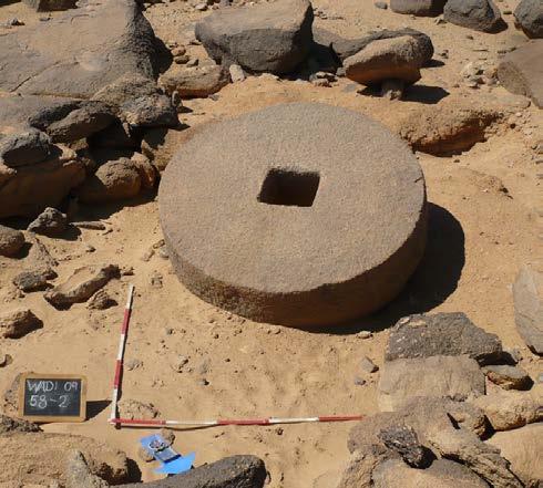
3 Site 13 (see fig. 1-4): Hills of bedrock outcrop, approx. 12m high, on the south bank of the Wadi, nearly 4 km west of Ghazali. Around and on the hills 15 tumuli of Kerma and probably Post- Meroitic date. Between the rocks of the hills several cleft burials and possible shelters. The pottery found in the rocky area dates to the Kerma as well as Post-Meroitic period. Site 29 (see figs.5-7): One outcrop hill directly at the south bank of the Wadi, 1,5 km west of Ghazali. On the hill stone architecture, maybe of Medieval age (only very few sherds were found). In the rocks numerous rock pictures, mostly cattle, as well as an extended rock gong with at least ten different sounds. Site 73 (see fig. 8): South bank of the Wadi, ca. 1,5km west of Ghazali. Outcrop hill with at least four shelters, pottery of Medieval age. The situation of simple shelters in the rocks near the center of Ghazali leads to the assumption that there might have been different patterns of subsistence (pastoral, hunting?). It should also be considered that the shelters may have been used by patrolling guards. Site 30 (see figs. 9-10): On the south bank of the Wadi, directly south to Site 29. Palaeolithic workshop. Different types of palaolithic tools. Site 58 (see figs ): On the north bank of the Wadi, opposite of Ghazali. Quarry of millstones with at least four millstones in different stages of preparation. The suggested date of Medieval time is based on some sherds found in the quarry. To find four mill stones (1,3 m in diameter) of hard stone let us suggest that the region of Ghazali functioned as center of supply for the area. 5. Proposal for future actitivities (5 years) a. After this preliminary campaign we plan to follow the Wadi Abu Dom, surveying intensively within the same parameters as we did in the first part. From now on the survey should include some sondages or trial excavations to establish the chronology of the human activity in the Wadi. b. To investigate the route between Napata and Meroe, trial excavations at some specific features would be helpful. We propose to make sondages especially at Umm Ruweim1, which seems to be a very important tradepoint in Medieval times. Since the site is situated at an anglepoint of roads and in the distance of a day-trip to Napata, we expect to find traces of activity in Napatan/Meroitic times at least at that site. In contrast to the notes of Chittick, who reported rough Meroitic sherds, we identified only Post-Meroitic and Medieval pottery. c. We plan to make sondages at foot paths, too, to investigate the continutiy of the road network from ancient times up to now. It might be helpful to interview the recent inhabitants of the area according to their moves on the paths. d. To investigate the social complexity of the area of Ghazali, we would propose making a trial excavation in one of the camp sites on the north bank of the Wadi, opposite the known town site of Ghazali. As the surface finds on these camp sites are all of Medieval date, it would be useful to
4 know if these camp sites really date to this period or if the numerous sherds were spread over the abandoned site. In case the camp site is also of Medieval date, an investigation of the different patterns of habitation sites (town/camp site), possible economic background (industrial/pastoral) and religious beliefs (Christian/Pagan) in this restricted area would be fruitful. 6. Endangered sites We have to point out that most of the recognised tumuli seemed to be plundered, maybe already in ancient times. In three instances the damages look very recent.: a. Site 13, tumuli of Kerma (18 27'03 N b/ 31 54'08 E): In the SW of the site tracks of a truck led directly to a tumulus, it seems that stones of the grave were transported. This is alarming, since the tumulus next to that one seems to be intact. b. Khala (18 25'01 N / 31 58'29 E): Post-Meroitic tumuli, two of them seemed to be opened more or less recently. At the top of one sherds of smashed pottery were collected by us.. c.cemetery east of Quweib (18 24'18,5 / 32 03'24,6 ): Post-Meroitic tumuli, one opened very recently, smashed pottery near the hole and inside (collected by us). We would like to thank Mr. Mohammed Toum very much for all his indispensable help and smooth organisation as well as the team of Dr. Tim Kendall and Mr. El Hassan Ahmed Mohamed for their support. Karima, Angelika Lohwasser
 and most important sites")
5 Map 1: Location of Wadi Abu Dom in Northern Sudan Map 2: Survey Area (grey) and most important sites (X)


 Fig.")
 sherds (at a path in the")
6 Fig. 1: Feature 30 of site 13, tumulus at the bottom of hill. Fig. 2: Feature 32 of Site 13, Cleft burial in the rocky area Fig. 3: Kerma sherd (at Cleft burial, Ft. 18 of Site 13) Fig. 4: Post-Meroitic (?) sherds (at a path in the rocky area of site 13)


7 Fig. 5: Site 29, stone architecture at the top, rock pictures on the hill. Fig. 6+7: Site 29, Rock pictures of various cows.


8 Fig. 8: Site 73, Shelter 2. Fig. 9: Site 30, palaeolithic blades (dorsal and ventral) Fig. 10: Site 30, Palaeolithic bifacial artefacts (both sides)


9 Fig : Site 58, four stages in the production of mill stones
Merowe Dam Archaeological Salvage Project (MDASP)
") Merowe Dam Archaeological Salvage Project (MDASP) Salah Mohamed Ahmed Introduction The idea of building a dam at the 4 th Cataract of the Nile dates to the period of the Anglo-Egyptian administration in
Merowe Dam Archaeological Salvage Project (MDASP) Salah Mohamed Ahmed Introduction The idea of building a dam at the 4 th Cataract of the Nile dates to the period of the Anglo-Egyptian administration in
Report of the Project "Wadi Abu Dom Itinerary" Fifth Season, (fieldactivity)
") Report of the Project "Wadi Abu Dom Itinerary" Fifth Season, 18.1.-16.3.2014 (fieldactivity) (funded by the German Research Foundation, Germany, and the Qatar Sudan Archaeological Project) Angelika Lohwasser
Report of the Project "Wadi Abu Dom Itinerary" Fifth Season, 18.1.-16.3.2014 (fieldactivity) (funded by the German Research Foundation, Germany, and the Qatar Sudan Archaeological Project) Angelika Lohwasser
Gebel Barkal (Sudan) No 1073
 No 1073") Gebel Barkal (Sudan) No 1073 1. BASIC DATA State Party : Republic of Sudan Name of property: Gebel Barkal and the Sites of the Napatan Region Location: Northern state, province of Meroe Date received:
Gebel Barkal (Sudan) No 1073 1. BASIC DATA State Party : Republic of Sudan Name of property: Gebel Barkal and the Sites of the Napatan Region Location: Northern state, province of Meroe Date received:
Tracks in the Bayuda desert. The project 'Wadi Abu Dom Itinerary' (W.A.D.I.)
") Originalveröffentlichung in: Frank Förster und Heiko Riemer (Hg.), Desert Road Archaeology in Ancient Egypt and Beyond (Africa Parehistorica 27), Köln 2013, S. 425-435 Angelika Lohwasser Tracks in the
Originalveröffentlichung in: Frank Förster und Heiko Riemer (Hg.), Desert Road Archaeology in Ancient Egypt and Beyond (Africa Parehistorica 27), Köln 2013, S. 425-435 Angelika Lohwasser Tracks in the
A Survey in the Western Bayuda: The Wadi Abu Dom Itinerary Project (WA.D.L) 1
 1") Originalveröffentlichung in: Sudan & Nubia 16, 2012, S. 109-117 SUDAN & NUBIA A Survey in the Western Bayuda: The Wadi Abu Dom Itinerary Project (WA.D.L) 1 Angelika Lohwasser The region within the large
Originalveröffentlichung in: Sudan & Nubia 16, 2012, S. 109-117 SUDAN & NUBIA A Survey in the Western Bayuda: The Wadi Abu Dom Itinerary Project (WA.D.L) 1 Angelika Lohwasser The region within the large
SUDAN. The Kingdom of the Black Pharaohs. GUARANTEED DEPARTURES (min. 4 pax)
") SUDAN The Kingdom of the Black Pharaohs 10 days all accommodated tour + possible extension to Soleb GUARANTEED DEPARTURES (min. 4 pax) This tour shows all the major archaeological sites of the Northern
SUDAN The Kingdom of the Black Pharaohs 10 days all accommodated tour + possible extension to Soleb GUARANTEED DEPARTURES (min. 4 pax) This tour shows all the major archaeological sites of the Northern
Ancient Kingdoms of Sudan. 12 Days
 Ancient Kingdoms of Sudan 12 Days Ancient Kingdoms of Sudan On this extraordinary adventure through rarely visited Sudan, journey across breathtaking deserts, ancient pyramids, and buzzing markets. Cruise
The Italian Archaeological Mission in Sudan Ca Foscari University of Venice
 The Italian Archaeological Mission in Sudan Ca Foscari University of Venice Karima (Sudan) November-December 2012 The 2012 season of the Italian Archaeological Mission at Jebel Barkal was carried out between
SUDAN. The Kingdom of the Black Pharaohs
 SUDAN The Kingdom of the Black Pharaohs 10 days all accommodated tour + possible extension to Soleb Season 2015-2016 GUARANTEED DEPARTURES (min. 4 pax) This tour shows all the major archaeological sites
The Semna South Project
 The Semna South Project Louis V. Zabkar For those who have never visited the area of southern Egypt and northern Sudan submerged by the waters of the new Assuan High Dam, and who perhaps find it difficult
(Images forthcoming) Napata Town Site:
 Napata Town Site:") (Images forthcoming) Napata Town Site: Napata was the name of the ancient city surrounding Jebel Barkal. Located on the right (north) bank of the Nile, 23 km. downstream from the mouth of the fourth cataract,
(Images forthcoming) Napata Town Site: Napata was the name of the ancient city surrounding Jebel Barkal. Located on the right (north) bank of the Nile, 23 km. downstream from the mouth of the fourth cataract,
VOCABULARY WORDS. ceramic trade route mineral. independence ally trading network decipher. obelisk
 Nubia and Kush VOCABULARY WORDS ceramic trade route mineral independence ally trading network decipher obelisk Ceramic Ceramic: A product that is made from baked clay. Trade Route Trade route: A path that
SUDAN 2018 The Kingdom of The Black Pharaohs (12 days) Includes Kerma and Soleb
 Includes Kerma and Soleb") 930 Irwin Street, Suite 222, San Rafael, CA 94901 Phone: 415-381-5861 888-367-6147 inquire@originalworld.com www.originalworld.com CST Permit #2057026-40 SUDAN 2018 The Kingdom of The Black Pharaohs (12
930 Irwin Street, Suite 222, San Rafael, CA 94901 Phone: 415-381-5861 888-367-6147 inquire@originalworld.com www.originalworld.com CST Permit #2057026-40 SUDAN 2018 The Kingdom of The Black Pharaohs (12
TH E FIRST SEASON of investigations at the
 QUSEIR AL-QADIM Janet H. Johnson & Donald Whitcomb TH E FIRST SEASON of investigations at the ancient port of Quseir al-qadim on the Red Sea in Egypt took place in winter, 1978; the investigations were
CULTURAL HERITAGE RESOURCES IMPACT ASSESSMENT ON MALOKONG HILL
 CULTURAL HERITAGE RESOURCES IMPACT ASSESSMENT ON MALOKONG HILL AFRICAN HERITAGE CONSULTANTS CC 2001/077745/23 Tel/fax: (012) 567 6046 Cell: 082 498 0673 E-mail: udo.heritage@absamail.co.za DR. UDO S KÜSEL
C.V. I- Specialization: Archaeology II- BA Honors III- Date: IV- University: - University of Khartoum, Sudan.
 C.V I. Personal data: - Name : Intisar Soghayroun Elzein Date of birth : 13.3.1958 Nationality : Sudanese Marital status : married and mother of 3 children, born 1987, 91, 94. Address : P.O. Box 35, Khartoum,
Nile Valley and Western Desert 16 days expedition
 930 Irwin Street, Suite 222, San Rafael, CA 94901 Phone: 415-381-5861 888-367-6147 inquire@originalworld.com www.originalworld.com CST Permit #2057026-40 Nile Valley and Western Desert 16 days expedition
Sudanese Nubia 8 Days/7 Nights All Meals Included All Gratuities Included
 Sudanese Nubia 8 Days/7 Nights All Meals Included All Gratuities Included Featuring: Mogran Park. National Museum. Khalifa Museum. Old Dongola. Jebel Barkal. Kurru. Pyramids of Nuri. Gazali Valley and
Lordenshaw. What are cup & ring marks?
 Lordenshaw Lordenshaw hill has one of the largest clusters of ancient cup and ring marked stones in the UK. We ve chosen four interesting spots we d like to share with you. What are cup & ring marks? The
Following the initial soil strip archaeology is sprayed up prior to planning and excavation
 Barton Quarry & Archaeology Over the past half century quarries have been increasingly highlighted as important sources of information for geologists, palaeontologists and archaeologists, both through
TRAVEL AND EXPEDITION MINI GUIDE SUDAN THE KINGDOM OF THE BLACK PHARAOHS
 TRAVEL AND EXPEDITION SUDAN THE KINGDOM OF THE BLACK PHARAOHS 2 THE KINGDOM OF THE BLACK PHARAOS All accommodated tour through the most important Nubian archaeological sites with encounters with people
B 1200: The Napatan palace and the Aspelta throne room.
 B 1200: The Napatan palace and the Aspelta throne room. The labyrinthine mud brick walls southwest of B 800 are the remains of the Napatan palace, designated "B 1200," at Jebel Barkal (fig. 1). Until now
A 'FUTHARK' FROM EIBI, EYSTUROY, FAROE ISLANDS. John R. Baldwin
 36 A 'FUTHARK' FROM EIBI, EYSTUROY, FAROE ISLANDS John R. Baldwin Background Eidi is situated at the north-west corner of Eysturoy [Fig. 1], one of the largest of the Faroe Islands and containing Faroe's
Archaeologists unearth tombs in ancient Nubia
 Archaeologists unearth tombs in ancient Nubia Mon, Mar 05, 2018 Tombs, steles, and lintels have just been unearthed by an international team, with largest collection of Meroitic inscriptions, the oldest
Ancient Nubia: African Kingdoms On The Nile By Sue D'Auria, Peter Lacovara
 Ancient Nubia: African Kingdoms On The Nile By Sue D'Auria, Peter Lacovara Ancient Nubia: African Kingdoms on the Nile interview - YouTube - Book interview on NY1 CloseUp show interview for the book, Ancient
Development of African Agriculture
 Development of African Agriculture Sahara desert originally highly fertile region Western Sudan region nomadic herders, c. 9000 BCE Domestication of cattle c. 7500 BCE Later, cultivation of sorghum, yams,
IMTO Italian Mission to Oman University of Pisa 2011B PRELIMINARY REPORT (OCTOBER-DECEMBER 2011)
") IMTO Italian Mission to Oman University of Pisa 2011B PRELIMINARY REPORT (OCTOBER-DECEMBER 2011) The 2011B research campaign took place in the area around Salut from October, 19 th, to December, 16 th.
IMTO Italian Mission to Oman University of Pisa 2011B PRELIMINARY REPORT (OCTOBER-DECEMBER 2011) The 2011B research campaign took place in the area around Salut from October, 19 th, to December, 16 th.
Sudan and Ancient Nubia December 10-18, 2018 Escorted by Emily Teeter
 Sudan and Ancient Nubia December 10-18, 2018 Escorted by Emily Teeter Make this the year for a trip of a lifetime... Sudan and Ancient Nubia Celebrate 100 years of Oriental Institute exploration as we
A FIELDWALKING PROJECT AT HOLLINGBURY, BRIGHTON. by JOHN FUNNELL
 Introduction A FIELDWALKING PROJECT AT HOLLINGBURY, BRIGHTON by JOHN FUNNELL Members of the Brighton and Hove Archaeological Society walked the field at Hollingbury during the months of December 1991 and
Gorse Stacks, Bus Interchange Excavations Interim Note-01
 Gorse Stacks, Bus Interchange Excavations 2015 Prepared for: Cheshire West & Chester Council Interim Note-01 1 Introduction & Summary Background Since c. 2000 investigations associated with redevelopment
THE DEVELOPMENT OF HARVARD UNIVERSITY REPRINT FROM SINCE THE INAUGURATTON OF PRESIDENT ELIOT SAMUEL ELIOT MORISON EGYPTOLOGY, CHAPTER XIV
 REPRINT FROM THE DEVELOPMENT OF HARVARD UNIVERSITY SINCE THE INAUGURATTON OF PRESIDENT ELIOT 1869 1929 EDITED BY SAMUEL ELIOT MORISON CLASS OF I908 CHAPTER XIV EGYPTOLOGY, 1896-1928 BY GEORGE ANDREW REISNER,
Survey and Excavation at el-multaga, a Resettlement Area related to the Construction of the Merowe Dam: preliminary results
 Survey and Excavation at el-multaga, a Resettlement Area related to the Construction of the Merowe Dam: preliminary results Francis Geus and Yves Lecointe Introduction The idea of building a dam on the
Archaeological Investigations Project South East Region SOUTHAMPTON 2/842 (C.80.C004) SU
 SU") SOUTHAMPTON City of Southampton 2/842 (C.80.C004) SU 4382 1336 125 BITTERNE ROAD WEST, SOUTHAMPTON Report on the Archaeological Evaluation Excavation at 125 Bitterne Road West, Southampton Russel, A. D
SOUTHAMPTON City of Southampton 2/842 (C.80.C004) SU 4382 1336 125 BITTERNE ROAD WEST, SOUTHAMPTON Report on the Archaeological Evaluation Excavation at 125 Bitterne Road West, Southampton Russel, A. D
A Near Eastern Megalithic Monument in Context
 Special Volume 3 (2012), pp. 143 147 Mike Freikman A Near Eastern Megalithic Monument in Context in Wiebke Bebermeier Robert Hebenstreit Elke Kaiser Jan Krause (eds.), Landscape Archaeology. Proceedings
Sudan Kingdom of the Nubian Pharaohs
 Sudan Kingdom of the Nubian Pharaohs January 8 to 23, 2019 Stanford Travel/Study changed our travel lives. We have great memories of the many places we have been and people with whom we have traveled.
FOUNDATIONS OF ARCHAEOLOGY A WALK IN VERNDITCH CHASE
 FOUNDATIONS OF ARCHAEOLOGY A WALK IN VERNDITCH CHASE 1. A Tale of two Long Barrows Long barrows were constructed as earthen or drystone mounds with flanking ditches and acted as funerary monuments during
Babylon. Ancient Cities by the River Lesson 5 page 1 of 6. Code of Hammurabi monument. E u p h. T i g r i s. r a t e s. Babylon, Mesopotamia
 Ancient Cities by the iver Lesson 5 page 1 of 6 1700s BCE, and established the importance of the city for the region He was responsible for a code of laws/decrees to reestablish justice in the land His
Trip log for Oriental Institute Sudan tour, December 2018
 Trip log for Oriental Institute Sudan tour, December 2018 Mon 10 Dec: We, along with much of the tour group, arrived at Khartoum airport from Cairo, at around 6:30 pm. We were met by a representative of
archeological site LOS MILLARES
 archeological site LOS MILLARES Aerial view of the plain of Los Millares between the Rambla de Huéchar and the River Andarax The archaeological site of Los Millares is located in the township of Santa
Shaded relief map of Egypt
 PHYSICAL LANDSCAPES OF ANCIENT EGYPT EGYPT: GIFT OF THE NILE - HERODOTUS MODIS (Moderate Resolution Imaging Spectroradiometer) image of the Nile River Valley, from NASA. Dr. John Paul Stimac Honors College
SEVEN LAYER MONUMENTS OF THE EARLY OLD KINGDOM FORTHCOMMING
 SEVEN LAYER MONUMENTS OF THE EARLY OLD KINGDOM FORTHCOMMING إن شاء هللا FUNERARY PYRAMIDS Are: Stepped, Bent, Benben, or of True forms with some PROPERTIES namely: 1 - Correctness of SHAPE, 2 - STABILITY
The Neolithic of the Fourth Cataract Marek Chłodnicki, Muzeum Archeologiczne, Poznań
 The Neolithic of the Fourth Cataract Marek Chłodnicki, Muzeum Archeologiczne, Poznań The Fourth Cataract region was penetrated archaeologically already in the 19 th century, but early travelers took notice
THE EL-QITAK PROJECT. oi.uchicago.edu
 oi.uchicago.edu THE EL-QITAK PROJECT T H O M A S - L - M C C L E L L A N T he 1987 season at el-qitar ran from May 2 t o July 29th and marked the last major season of excavation there because the site
How the Nile River Led to Civilization in Ancient Egypt
 How the Nile River Led to Civilization in Ancient Egypt By USHistory.org, adapted by Newsela staff on 03.07.17 Word Count 786 Level 950L TOP: This photo, taken around 1915, shows the flooding of the Nile
CEAUCP - Tróia Summer School. Roman Ruins of Tróia (Portugal)
") CEAUCP - Tróia Summer School Roman Ruins of Tróia (Portugal) 3 rd to 29 th June 2013 1 The CEAUCP Tróia Summer School is a new Summer archaeological fieldschool program offered by the Centre of Archaeological
CEAUCP - Tróia Summer School Roman Ruins of Tróia (Portugal) 3 rd to 29 th June 2013 1 The CEAUCP Tróia Summer School is a new Summer archaeological fieldschool program offered by the Centre of Archaeological
As both one of the few substantially preserved pharaonic Egyptian. expulsion, the site of Deir el-ballas is of great archaeological and historic
 The 2017 Season at Deir el-ballas Peter Lacovara As both one of the few substantially preserved pharaonic Egyptian settlements as well as the forward capital for the Theban kings during the Hyksos expulsion,
ARCHAEOLOGY IN TUCSON
 ARCHAEOLOGY IN TUCSON Vol.1, No.4 Newsletter of the Institute for American Research Summer 1987 TRULY THE ORIGINAL TUCSON! In our last AIT newsletter, we presented some of the background about the San
PRELIMINARY NOTES ON TWO ROYAL BUILDINGS DISCOVERED IN NAPATA 1. Loredana Sist - Roma
 [Vicino & Medio Oriente XV (2011), pp. 159-166] PRELIMINARY NOTES ON TWO ROYAL BUILDINGS DISCOVERED IN NAPATA 1 Loredana Sist - Roma It is well known that the imposing character of Natakamani s palace
from the source to Aswan
 The Nile: from the source to Aswan Version 1.0 These programmes on The World of Ancient Art been designed for students and the public. They use material on the web to show the wealth of information that
the basic principle of justice in Hammurabi s Code ( an eye for an eye ). (H, C, E)
. (H, C, E)") SEPTEMBER OCTOBER NOVEMBER HUMAN ORIGINS IN AFRICA THROUGH THE NEOLITHIC AGE 7.1 Describe the great climatic and environmental changes that shaped the earth and eventually permitted the growth of human
SEPTEMBER OCTOBER NOVEMBER HUMAN ORIGINS IN AFRICA THROUGH THE NEOLITHIC AGE 7.1 Describe the great climatic and environmental changes that shaped the earth and eventually permitted the growth of human
The Tel Burna Archaeological Project Report on the First Season of Excavation, 2010
 The Tel Burna Archaeological Project Report on the First Season of Excavation, 2010 By Itzick Shai and Joe Uziel Albright Institute for Archaeological Research Jerusalem, Israel April 2011 The site of
The Roman Rural Settlement Project
 The Roman Rural Settlement Project Preliminary results from the East Midlands Dr Tom Brindle Crown Copyright/database right 2013. The East Midlands dataset 544 records of LIA/Roman sites 15% of Jeremy
4. Bronze Age Ballybrowney, County Cork Eamonn Cotter
 4. Bronze Age Ballybrowney, County Cork Eamonn Cotter Illus. 1 Location map of the excavated features at Ballybrowney Lower (Archaeological Consultancy Services Ltd, based on the Ordnance Survey Ireland
IAS Prelims Exam: Ancient History NCERT Questions: The Harappan Civilisation Set II
 IAS Prelims Exam: Ancient History NCERT Questions: The Harappan Civilisation Set II Questions asked from Ancient Indian History section in IAS Prelims Exam are quite easy but the candidates need to memorise
Jneneh in the Upper Wadi az-zarqa, in North Central Jordan, First Season 2011.
 Jneneh in the Upper Wadi az-zarqa, in North Central Jordan, First Season 2011. Khaled Douglas Jneneh is located in the north-western periphery of the city of Zarqa (grid ref. 250.88E 165.25N), in North
AN ARCHAEOLOGICAL ASSESSMENT OF BOERNE CITY PARK, KENDALL COUNTY, TEXAS. Thomas C. Kelly and Thomas R. Hester
 AN ARCHAEOLOGICAL ASSESSMENT OF BOERNE CITY PARK, KENDALL COUNTY, TEXAS Thomas C. Kelly and Thomas R. Hester Center for Archaeological Research The University of Texas at San Antonio Archaeological Survey
Brenig Archaeology Trail
 Walk Information: Maps: OS Explorer 264 Distance: 2.5 miles / 4 kilometres Duration: Allow 2.5 hours for the circular walk Difficulty: easy. Well-marked trail over fields. Start and finish: SH 98325741
Excavations in a Medieval Market Town: Mountsorrel, Leicestershire,
 Excavations in a Medieval Market Town: Mountsorrel, Leicestershire, by John Lucas Mountsorrel is situated 12 kms north of Leicester and forms a linear settlement straddling the A6, Leicester to Derby road.
Connect With Us National Geographic Daily News
 Page 1 of 5 Connect With Us National Geographic Daily News Page 2 of 5 Huge Gladiator School Found Buried in Austria "Important" find boasts amphitheater, was nearly as big as two Walmarts. Digital reconstruction
How the Nile River Led to Civilization in Ancient Egypt
 How the Nile River Led to Civilization in Ancient Egypt By USHistory.org on 03.07.17 Word Count 1,108 Level MAX TOP: This photo, taken around 1915, shows the flooding of the Nile River, which happens each
Ancient Egypt and the Near East
 *O*»f ' i ft Ancient Egypt and the Near East Chapter 7 Chapter 8 Chapter 9 Geography and the Early Settlement of Egypt, Kush, and Canaan The Ancient Egyptian P h a r a o h s Daily Life in Ancient Egypt
Name: Period: Date: Mediterranean Sea , '13"N 18 48'30"E. Nile River , '14.06"N 31 26'27.
 Name: : Date: Directions: Label the items in this column on the map. Mediterranean Sea 35.603719, 18.808594 35 36'13"N 18 48'30"E Nile River 26.853906, 3440919 26 51'14.06"N 31 26'27.31"E River Current
AFRICAN CIVILIZATION. The Kushite Kingdom in Upper Egypt and the Sudan
 AFRICAN CIVILIZATION The Kushite Kingdom in Upper Egypt and the Sudan The Kingdom of Kush The civilization of Kush thrived from about 2000 B.C.E. to 350 C.E. Kush and Egypt had a close relationship throughout
Nubia after the fall of Meroe: 'Group X'
 The empire of Kush: Napata and Meroe kingdom of Aksum, which had grown up on the high table-lands of present-day Ethiopia, had rapidly attained the summit of its power; Ezana, 40 thefirst monarch to embrace
The Rosetta Stone. Writing in Ancient Egyptian
 Writing in Ancient Egyptian The Rosetta Stone The hieroglyphic writing system used more than 600 symbols, mostly pictures of objects. Each symbol represented one or more sounds in the Egyptian language.
The Nile flows in two great bends through six
 The Meroitic inscriptions in Egypt* Ahmed Mansour The Nile flows in two great bends through six cataracts from Khartoum near the center of Sudan to Lake Nasser and Aswan on the modern border between Sudan
Lesson 8 Wilderness: Human Uses, Past and Present
 Lesson 8 Wilderness: Human Uses, Past and Present Objectives: Students will: recognize that cultural resources are part of Wilderness and that these resources provide information about how the area was
You Will Need: Your notebook Your textbook Your pencil
 You Will Need: Your notebook Your textbook Your pencil Today you will learn about the kingdoms of Kush and Aksum who developed advanced civilizations with large trading networks. Kush and Aksum Kush and
The importance of Jerusalem for the study of Near Eastern history and. archaeology and for the study of the Biblical text (both old and new) cannot
 cannot") Setting the Clock in the City of David: Establishing a Radiocarbon Chronology for Jerusalem's Archaeology in Proto-historical and Historical Times Yuval Gadot, Johana Regev, Helena Roth and Elissabeta
Setting the Clock in the City of David: Establishing a Radiocarbon Chronology for Jerusalem's Archaeology in Proto-historical and Historical Times Yuval Gadot, Johana Regev, Helena Roth and Elissabeta
STUDENTS WILL BE ABLE TO IDENTIFY THE MAJOR GEOGRAPHIC FEATURES OF EGYPT AND THE SURROUNDING REGION
 SOUTHWESTERN CHRISTIAN SCHOOL WORLD HISTORY STUDY GUIDE # 7 : ANCIENT EGYPT 3,000 BC 200 BC LEARNING OBJECTIVES STUDENTS WILL BE ABLE TO IDENTIFY THE MAJOR GEOGRAPHIC FEATURES OF EGYPT AND THE SURROUNDING
We have compared the way a historian works to the way a detective
 2.8 Primary and Secondary Sources We have compared the way a historian works to the way a detective works. The main difference between detectives and historians is the evidence they work with. Detectives
Egyptian Pyramids. Ancient Egyptian Art: Day 2
 Egyptian Pyramids Ancient Egyptian Art: Day 2 The Old Kingdom: Most people associate pyramids with the great Old Kingdom pyramids at Giza. The gigantic stone pyramids were actually built over the course
GESELLSCHAFT ZUR FÖRDERUNG VON MUSEEN IN ÄTHIOPIEN E.V. (GFMÄ)
") GESELLSCHAFT ZUR FÖRDERUNG VON MUSEEN IN ÄTHIOPIEN E.V. (GFMÄ) REPORT ON ARCHAEOLOGICAL FIELD TRIP TO ETHIOPIA 10th-20th OCTOBER 2016 Ethiopian-German Expedition to Wuqro Deutschen Archäologischen Instituts
GESELLSCHAFT ZUR FÖRDERUNG VON MUSEEN IN ÄTHIOPIEN E.V. (GFMÄ) REPORT ON ARCHAEOLOGICAL FIELD TRIP TO ETHIOPIA 10th-20th OCTOBER 2016 Ethiopian-German Expedition to Wuqro Deutschen Archäologischen Instituts
2. 4 Avebury: stone circles and nearby sites
 24 2. 4 Avebury: stone circles and nearby sites N E W S Beckhampton Avenue The bank originally stood 7 m (23 ft) high, much taller than today. The ditch was originally 9 m (30 ft) deep and 20 m (65 ft)
Jane C. Waldbaum Archaeological Field School Scholarship - Report.
 Jane C. Waldbaum Archaeological Field School Scholarship - Report. Eastern Boeotia Archaeological Project, 2017 Novella Nicchitta Figure 1 EBAP's team for 2017 This year I had the pleasure of participating
The Greek-Swedish-Danish Excavations at Kastelli, Khania 2010 a short report
 The Greek-Swedish-Danish Excavations at Kastelli, Khania 2010 a short report During six weeks from 19 July to 27 August the Greek-Swedish-Danish Excavations continued work in the Ag. Aikaterini Square
Black Pharaohs. Rulers of Ancient Nubia. by Thomas Kummert
 Black Pharaohs Rulers of Ancient Nubia by Thomas Kummert www.ancient-cultures.info Everybody has heard of and many even visited the massive pyramids and incredible royal tombs of the legendary Egyptian
PALMYRENA PALMYRA AND THE SURROUNDING TERRITORY JOINT SYRIAN-NORWEGIAN PROJECT SURFACE SURVEY NORTH OF PALMYRA APRIL AND MAY 2009.
 PALMYRENA PALMYRA AND THE SURROUNDING TERRITORY JOINT SYRIAN-NORWEGIAN PROJECT SURFACE SURVEY NORTH OF PALMYRA APRIL AND MAY 2009. PRELIMINARY REPORT PREHISTORIC PERIODS Nils Anfinset 2009 CONTENTS Abstract
In 2014 excavations at Gournia took place in the area of the palace, on the acropolis, and along the northern edge of the town (Fig. 1).
.") Gournia: 2014 Excavation In 2014 excavations at Gournia took place in the area of the palace, on the acropolis, and along the northern edge of the town (Fig. 1). In Room 18 of the palace, Room A, lined
Gournia: 2014 Excavation In 2014 excavations at Gournia took place in the area of the palace, on the acropolis, and along the northern edge of the town (Fig. 1). In Room 18 of the palace, Room A, lined
Chapter 4. Ancient Egypt and Kush Section 1: Geography & Ancient Egypt
 Chapter 4 Ancient Egypt and Kush Section 1: Geography & Ancient Egypt The gift of the nile Geography played a key role in the development of the Egyptian civilization. The Nile River brought life to Egypt.
ANNUAL REPORT: ANCIENT METHONE ARCHAEOLOGICAL PROJECT 2014 FIELD SCHOOL
 ANNUAL REPORT: ANCIENT METHONE ARCHAEOLOGICAL PROJECT 2014 FIELD SCHOOL Director(s): Co- Director(s): Professor Sarah Morris, Cotsen Institute of Archaeology, UCLA John K. Papadopoulos, Cotsen Institute
CARLUNGIE EARTH HOUSE
 Property in Care (PIC) ID: PIC015 Designations: Scheduled Monument (SM90059) Taken into State care: 1953 (Guardianship) Last reviewed: 2004 HISTORIC ENVIRONMENT SCOTLAND STATEMENT OF SIGNIFICANCE CARLUNGIE
IKLAINA ARCHAEOLOGICAL PROJECT 2012 FIELD REPORT
 IKLAINA ARCHAEOLOGICAL PROJECT 2012 FIELD REPORT Michael B. Cosmopoulos The sixth season of the Iklaina Archaeological Project was conducted for six weeks in June and July 2012. Τhe project is conducted
Archaeological Investigation of Coloane, Macau
 Archaeological Investigation of Coloane, Macau Received 13 March 1974" W. KELLY AND W. MEACHAM INTRODUCTION UP UNTIL July 1972, when a field survey of Coloane Island was undertaken by members of the Hong
EXCAVATIONS AT AIXONIDAI HALAI VOULA FIELD SCHOOL
 EXCAVIONS HALAI J A N U A R Y 8-2 7, 2 0 1 8 I N S T R U C T O R : D R. J O H N K A R A V A S VOULA FIELD SCHOOL EXCAVIONS HALAI COURSE DETAILS Dates : January Students who have a serious interest in archaeology
New Studies in the City of David The Excavations
 The 2013-2014 Excavations Israel Antiquities Authority The intensive archaeological work on the city of David hill during the period covered in this article has continued in previously excavated areas
oi.uchicago.edu ARCHEOLOGY
 ARCHEOLOGY Janet H. Johnson and Donald Whitcomb Quseir al-qadim The small port of Quseir al-qadim, Egypt, is situated on the north bank of the Wadi Quseir al-qadim where the wadi meets the Red Sea; it
B 500: The Great Amun Temple under the Kushites. B 500-Phases VI and VII: Piankhy
 B 500: The Great Amun Temple under the Kushites B 500-Phases VI and VII: Piankhy Not until the rise of the Kushites in the early 8th century BC were new renovations undertaken on B 500. By this time the
Azoria 2004 B700 Final Trench Report RQC
 Azoria 2004 B700 Final Trench Report RQC B700 is a room -2.5m by 4.5m, bounded by wall B711 to north, wall B703 to east, wall B706 to south, and wall B717 to west. B700 is an Archaic storeroom with an
The Syrian Middle Euphrates Archaeological Project (PAMES).
.") The Syrian Middle Euphrates Archaeological Project (PAMES). Seven years of research (2005-2011) of the Spanish and Syrian Archaeological Mission in Deir ez-zor. With the support of Aïdi Foundation In September
The Syrian Middle Euphrates Archaeological Project (PAMES). Seven years of research (2005-2011) of the Spanish and Syrian Archaeological Mission in Deir ez-zor. With the support of Aïdi Foundation In September
Chapter 7: The Geography and Settlement of Egypt, Kush, and Canaan
 Chapter 7: The Geography and Settlement of Egypt, Kush, and Canaan Learning Target: I can explain how geography affected early settlement in Egypt, Kush, and Canaan. Ancient Egypt and the Middle East Can
THE MAHAS SURVEY 1991
 THE MAHAS SURVEY 1991 Interim Report & Site Inventory. David N Edwards & Ali Osman M.Salih Mahas Survey Reports No.1. 1992 ii ISSN 0967-7909 David N Edwards & Ali Osman 1992. Second printing 1998. Printed
An archaeological excavation at 193 High Street, Kelvedon, Essex September 2009
 An archaeological excavation at 193 High Street, Kelvedon, Essex September 2009 report prepared by Ben Holloway and Howard Brooks on behalf of Marden Homes CAT project ref.: 09/4g NGR: TL 8631 1913 (c)
Egypt and African Societies
 Egypt and African Societies Timeline 9000 BCE Origins of Sudanic Herding 7500 BCE - Origins of Sudanic cultivation 3100 BCE Unification of Egypt (Narmer Palette) 3100 2660 BCE Archaic Period 2660 2160
Antinoupolis. Ongoing Destruction. Pre-2006 crops. Modern cemetery covering. ancient cemetery. Antinoupolis, ancient city. North cemetery (ancient).
.") Antinoupolis Ongoing Destruction Ongoing Destruction North cemetery (ancient). Pre-2006 crops Modern cemetery covering ancient cemetery. Antinoupolis, ancient city. Modern village of el Sheikh Abada Nile
Antinoupolis Ongoing Destruction Ongoing Destruction North cemetery (ancient). Pre-2006 crops Modern cemetery covering ancient cemetery. Antinoupolis, ancient city. Modern village of el Sheikh Abada Nile
South from Kadruka: the Neolithic in the Northern Dongola Reach, Sudan
 Recent Research Into the Stone Age of Northeastem Africa Studies in African Archaeology 7 Poznan Archaeological Museum 2000 Derek A. Welsby South from Kadruka: the Neolithic in the Northern Dongola Reach,
REEVALUATING THE MIMBRES COLLAPSE AT THE BLACK MOUNTAIN SITE
 REEVALUATING THE MIMBRES COLLAPSE AT THE BLACK MOUNTAIN SITE Kathryn J. Putsavage Southwestern New Mexico is famous for its pottery, the remarkable black-on-white bowls of the Mimbres phase (A.D. 1000-1150)
'-~ Target ~ Reading Skill
 Prepare to Read Objectives In this section you will 1. Examine the relationship between Nubia and Egypt. 2. Learn about the Nubian kingdoms centered in Kerma, Napata, and Meroe. Taking Notes As you read,
oi.uchicago.edu TALL-E BAKUN
 TALL-E BAKUN ABBAS ALIZADEH After I returned in September 1991 to Chicago from Cambridge, Massachusetts, I began preparing for publication the results of 1937 season of excavations at Tall-e Bakun, one
Archaeological Discoveries and Developments in Egypt
 Archaeological Discoveries and Developments in Egypt Hatshepsut [sketch by Sakulchat Chatrakul Na Ayuddhaya] and Thutmose III ruled together for two years before she appointed herself pharaoh. Queen Hatshepsut