The Rhône, a river shaped by man
|
|
|
- Patricia Griffin
- 6 years ago
- Views:
Transcription

1 21


 Discharge rate at mouth: 1,700 m 3 /s")

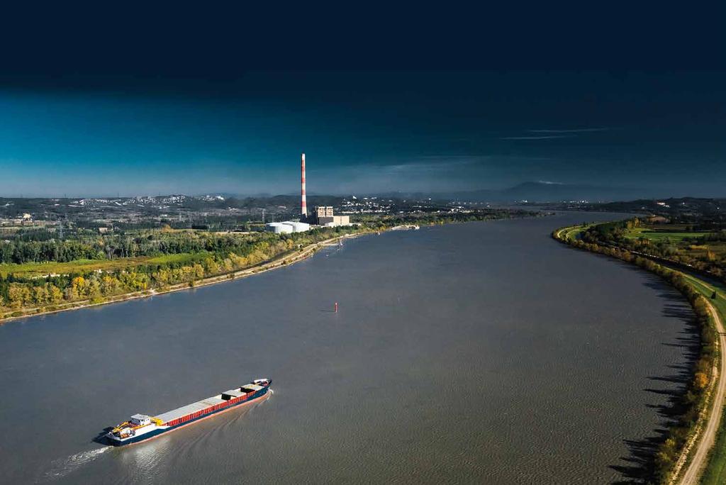
2 The Rhône, a river shaped by man Known as the Rotten in its upper reaches, the source of the Rhône is meltwater from the Furka glacier in the Swiss canton of Valais. It runs for 300 km before reaching Lake Geneva. The French section of the Rhône, from Lake Geneva to the River Saône, winds its way through the mountains of the Jura and the pre-alps before it reaches the Ain plain. At Lyon, the river meets the rocky obstacle that is the Massif Central, forcing it to change direction to run down a northsouth axis all the way to its delta, the Camargue. The Rhône basin is noteworthy for the diversity of climates - mountainous, The Furka glacier, like most other Alpine glaciers, has retreated a great deal over the last 150 years because of climate change. oceanic, continental, Mediterranean - influencing how the river functions. The Rhône is a major communication channel, engineered to optimise navigability, work on which started in the first half of the 19th century. Since 1934, navigability works, hydro-electricity, and the use of its waters for irrigation have all expanded. The Rhône is a river shaped by man with dykes and channels, deviated from its natural course long ago. DID YOU KNOW? The French portion of the Rhône now features 22 hydro-electric power plants, 16 nuclear reactors and 19 locks enabling the river to be navigated along some 300 km of its length. ATLANTIC OCEAN IDENTITY CARD Mouth of the Rhône carrying glacier sediment into Lake Geneva, on the Swiss side. Source: Furka glacier, Swiss Alps Mouth: Mediterranean Sea Length: 810 km (just over 500 miles) Discharge rate at mouth: 1,700 m 3 /s Catchment area: 0.1 million sq. km. Countries: Switzerland, France A cut-off (lône) is an abandoned or secondary branch of the Rhône. Most of them are the result of man-made changes to the river s direction. They are supplied with water by groundwater or directly by the river in times of flooding. The rivers Ain, Saône, Isère and Durance, the Rhône s four major tributaries, receive 60% of the catchment area s water. Confluence of the Rhône (right) and Saône (left) in Lyon. The temperature of the Rhône and its tributaries has risen substantially over the last 40 years. These changes are caused by climate change, a slower rate of flow, and discharges of hot water from the power plants. The Rhône discharges 54 billion cubic metres of water, which is 20% of the river water that flows into the Mediterranean 22


3 A complex river The Rhône tributaries show highly disparate monthly flow rates. Some, supplied by melting snow, have a strong flow in summer; others, mainly supplied by rainfall, have a greater hydrological regime in autumn and winter. The inflows from these rivers have different effects on Rhône s flow rate, floods and low water levels, depending on the location and the season. Different types of flood may occur in the Rhône basin in winter and autumn, i.e. oceanic towards the north, and Cévennes and extensive Mediterranean in the south, The Rhône basin receives heavy precipitation, some 1,100 mm on average per annum. In the Alps, precipitation of over 3 metres per annum has been measured, mainly in the form of snow. the latter two being extreme and sudden. If they occur at the same time or a few days apart, a general flood arises, often with devastating effects, as in According to researchers, the impact of climate change on the Rhône basin is difficult to assess. Separating the influence of this factor from others such as human activities and changes brought about to the environment is no easy matter. It is however proven that temperatures are rising, that evaporation is greater and that snow is melting earlier. Scientific organisations (IRSTEA France s National Research Institute of Science and Technology for Environment and Agriculture, CNRS - French National Centre for Scientific Research, France s meteorological office Météo-France, universities) have been working together for years on a whole range of programmes studying water resources and the impact of climate change. These hydroclimatic modelling projects, ranging from Gewex-Rhône to the current Modelling the Rhône programme, show the system s sensitivity to fluctuations brought about by man-made and natural causes. Average monthly flows Source: banque hydro The Isère is a tributary supplied by meltwater from snow and glaciers; the waters of the river Saône are essentially rainwater. The flows of each river will differ a great deal depending on the season. Owing to the varying hydrological regimes of the various sub-catchment areas and the various climates the river passes through, the Rhône has a complex flow pattern, which can experience episodes of flooding or low water at different times of the year. Downstream from Valence, the Rhône and its tributaries are affected by the Mediterranean climate, with autumn downpours resulting in frequent flooding, as here at les Gardons. The banks of the Rhône in Lyon in This general flood caused more than a billion euros of damage, making it one of the most costly floods ever to occur in France. Researchers anticipate an increase in air temperature of 1 to 3 C, unpredictable changes to winter precipitation (from -10% to 10%) and a 5% drop in summer rainfall. They have not, however, uncovered any clear trend in changes to floods. The Camargue is extremely vulnerable to Rhône floodwaters as its topography is flat and low-lying. It can become flooded if a dyke is breached, as here in December The river hit a rare peak flow of 11,500 m 3 /s in December


, local governments of regions through which the river passes, and research institutes.")


4 A subdued river Matter in motion in rivers can be split between alluvium and clay in suspension, and sand, gravel and pebbles washed along the river bed. In the Rhône s case, the transport of fine sediment in suspension and sand has been in decline for a century, but is still substantial. Gravel and pebbles being carried along the river bed has almost stopped. Consequently, only sand, alluvium and clay shape the plain and currently reach the mouth of the Rhône. The Girardon engineering structures designed to increase the depth of the navigable channel, together with large reservoir dams, hold back a large proportion of the sediment in suspension and the sand. The inflow of pebbles and gravel from tributaries is stopped by large-scale extraction of aggregates. With the scarcity of gravel inflows and the channelling of the river, it is now subdued and sluggish, its bed and banks no longer change and no longer rebuild themselves. The river s managers are currently working on dismantling the Girardon structures so as to limit the level of floods, increase the sediment carried by the river, and boost ecosystems by rehabilitating the Rhone s dead offshoots, the lônes, and adjoining land environments. The Rhône Sediment Observatory (OSR) is a multi-partner research platform, aiming to generate cross-disciplinary scientific knowledge over the long term delivering better understanding of the river system s dynamics and improved information for public operators. Partners include the Rhône Basin Long-term Environmental Research Observatory (ZABR), Rhône Valley Environmental Observatory (OHM-VR), river management bodies, government departments, French Water Agency, Compagnie Nationale du Rhône, EDF (electricity generating company), local governments of regions through which the river passes, and research institutes. Digues basses longitudinales Accumulation des galets Digue basse Epis plongeants From Lyon onwards, the Rhône has been gradually altered to improve flood protection and navigability, and generate hydro-electric power. These alterations have changed the river s transport of sediment, its geometry, and how the river works in general. Fine sediment carried through Arles is estimated at 10 million tonnes per annum, compared with 20 million in the 1950s and perhaps 30 million tonnes per annum at the end of the 19th century. Put in place between 1880 and 1920, the Girardon system, consisting of groynes, cross members and low dykes, reduced the river s width while making it deeper. The consequence of these engineering works was not only to lengthen the period when navigation was possible, but also to cut substantially into the river bed, reduce the diversity of depths, increase deposits of alluvia and sand on the banks, worsen the effects of floods and to cut off the Rhône s secondary branches. The Camargue coast is retreating because river s load of solid matter is taken directly out to sea by the outer branches of the delta, the Camargue being contained by dykes and isolated. Tributaries inflows of solids have been divided by 5, mainly from the removal of aggregates, especially at their mouths, certain HEP facilities, and the reduction of flow speed, which reduces the amount the river can carry. At Saintes-Maries de la Mer, in the Camargue, the German bunker originally built at the top of the beach is now submerged, which provides a measure of how far the coastline has retreated. The Génissiat dam is holding back over 12 million m 3 of various types of sediment 24


.")
 has increased significantly (42% on average).")

5 Back to the source After more than a century of development work, the Rhône has changed from a multiplecourse system to a channelled river. The remediation work has a number of aims, including to reintroduce and improve the transport of larger sediments, to reconnect and re-supply the cut-off branches (the lônes ), increase the flow in short-circuited sections, rehabilitate river habitats, and to restore fish migration routes. The lônes, cut off from the main river by dykes and flow regulators, fill with sand and silt, leading to the formation of separate bodies of water, ponds and ditches. Dredging the beds and removing some of the dykes improves water flow, recreating the diversity of habitats that is typical of alluvial plains. Other branches of the old Rhône river bed now receive just a fraction of the water they used to. The flow in these short-circuited sections has been increased to improve the ecological system and make a Rhône a swift flowing river once again. These measures are helping to re-establish ecological continuity and encourage fish to spread over a wider area of the basin. It is essential to monitor and analyse the effects of this restoration work to extend it to other sites in the Rhône basin, while taking account of the effects of human activities and climate change on these newly-created habitats. RhônEco (the scientific monitoring of the Rhone rehabilitation work) is a programme run by the aforementioned ZABR as part of the wider Rhône Plan. RhônEco focuses on ecological monitoring of the Old Rhône and its rehabilitated offshoots. It is a long-term research programme that aims to analyse the ecological impact of the rehabilitation, assess their predictability, and in so doing help to determine the river s ecological potential. Before After Since 1995, a hydraulic and ecological remediation programme has been underway, to recreate habitats and to attempt to restore the biodiversity that is characteristic of major central European rivers (Rhine, Rhône and Danube). Since the increase in reserved flow speed from 10 to 100 m 3 /s in 2000 in the Old Rhône around Pierre-Bénite, the relative abundance of some fish species (common bleak, beaked carp, dace) has increased significantly (42% on average). The cut-off branches ( lônes ) are remediated by dredging sediment and opening the channel downstream, and sometimes upstream. Before and after pictures of the Ciseland Iône in the Pierre Bénite area, south of Lyon. The flow in the old Rhône was cut (by 80 to 98%) to supply water to hydro-electricity plants through diversion channels. Old Rhône at Chautagne on the right, diversion channel on the left. Engineering structures and dams on the river have fragmented the water space. The travel of migratory fish is curbed, as in the shad of the Rhône. The Migratory Fish Management Plan implemented in 1993 allows the progressive reopening of migration routes. The zingel asper, the only species endemic to the basin, is no longer recorded in the Rhône itself, being found only in a few tributaries. The remediation of the Old Rhône is helping to safeguard hundreds of other animal and plant species 25
Geoscape Toronto The Oak Ridges Moraine Activity 2 - Page 1 of 10 Information Bulletin
 About 13,000 years ago as the Laurentide Ice Sheet melted, glacial meltwater accumulated between the ice sheet and the Niagara Escarpment. This formed a lake basin into which gravel and sand were deposited.
SUPPORT TO WATER RESOURCES MANAGEMENT IN THE DRINA RIVER BASIN DRAFT ROOF REPORT INTRODUCTION AND GENERAL APPROACH
 SUPPORT TO WATER RESOURCES MANAGEMENT IN THE DRINA RIVER BASIN DRAFT ROOF REPORT INTRODUCTION AND GENERAL APPROACH Nadja Zeleznik, REC Public Concultation Beograd, Serbia, 4 July 2017 1 1. Introduction
The Lower Prut Floodplain Natural Park (Romania)
") The Lower Prut Floodplain Natural Park (Romania) Gabriela Costea Natural Sciences Museum Complex Galati (Romania) & member of the Scientific Council of the Lower Prut Floodplain Natural Park The Prut The
The Lower Prut Floodplain Natural Park (Romania) Gabriela Costea Natural Sciences Museum Complex Galati (Romania) & member of the Scientific Council of the Lower Prut Floodplain Natural Park The Prut The
The Vjosa River in Albania
 The Vjosa River in Albania Europe s Wild jewel - beautiful, unknown and threatened The extensive braided river section near Tepelena would drown in a reservoir of the future Kalivaç dam. (Romy Durst) Major
Observation of cryosphere
 Observation of cryosphere By Sagar Ratna Bajracharya (email: sagar.bajracharya@icimod.org) Samjwal Ratna Bajracharya Arun Bhakta Shrestha International Centre for Integrated Mountain Development Kathmandu,
Europe s wild jewel - The Vjosa River in Albania
 SAVE THE BLUE HEART OF EUROPE THE BALKAN RIVERS Europe s wild jewel - The Vjosa River in Albania BEAUTIFUL, UNKNOWN AND THREATENED The extensive braided river section near Tepelena would drown in a reservoir
Adaptation in the Everest Region
 Adaptation in the Everest Region Bhawani S. Dongol Program Officer-Freshwater Program WWF- The Global Conservation Organization bhawani.dongol@wwfnepal.org 26 March 2010 Himalayan water towers The Himalayan
A pilot flood retention area in La Bassée
 A pilot flood retention area in La Bassée Institution interdépartementale des barrages-réservoirs du bassin de la Seine 8, rue Villiot - 75012 Paris - Tél. : 01 44 75 29 29 - Télécopie : 01 44 75 29 30
Terrestrial Protected Area Nomination: Central Mangrove Wetland South-West, Grand Cayman
 Terrestrial Protected Area Nomination: Central Mangrove Wetland South-West, Grand Cayman The attached nomination, proposing that a parcel of land in the Central Mangrove Wetland be made a Protected Area
II. THE BOULDER CREEK DRAINAGE BASIN
 II. THE BOULDER CREEK DRAINAGE BASIN This section provides an overview of the watersheds and flood hazards associated with Boulder Creek and South Boulder Creek including descriptions of the drainage basins,
Striving for resilience in the face of climate change
 Striving for resilience in the face of climate change Three years and eight months have elapsed since the country suffered one of its worst flooding events, affecting a couple of districts mainly in east-south
Hydrology Input for West Souris River IWMP
 Hydrology Input for West Souris River IWMP Prepared by: Mark Lee Manitoba Water Stewardship 1 1 1 Overall view of: drainage area watershed characteristics gauging stations meteorological stations Runoff
FLOODS IN FRANCE Is there a change?
 Local and regional estimation of extreme hydrological events Lyon 2003 FLOODS IN FRANCE Is there a change? Hélène NIEL & Laurie GIRAUD Objective To answer questions raised by society and the scientific
Natural Factors Affecting the Level of Osoyoos Lake
 Natural Factors Affecting the Level of Osoyoos Lake Background Osoyoos Lake is operated under conditions prescribed by the International Joint Commission (IJC) and Figure 1 shows the ranges within which
International Osoyoos Lake Board of Control Annual Report to the International Joint Commission
 International Osoyoos Lake Board of Control 2015 Annual Report to the International Joint Commission Cover: Northern extent of Osoyoos Lake, where the Okanagan River enters the lake, 2015. View is to the
 AGREEMENT Between Director of the Białowieża National Park, based in Białowieża (Poland) and Director of the National Park Bialowieża Forest, based in Kamieniuki (Belarus) and Head Forester of the Białowieża
Alpine Strategy for Adaptation to Climate Change in the Field of Natural Hazards
 Nationale Plattform Naturgefahren PLANAT Plate-forme nationale Dangers naturels Plattaforma nazionale Pericoli naturali National Platform of Natural Hazards Alpine Strategy for Adaptation to Climate Change
Regional impacts and vulnerability mountain areas
 Regional impacts and vulnerability mountain areas 1 st EIONET workshop on climate change vulnerability, impacts and adaptation EEA, Copenhagen, 27-28 Nov 2007 Klaus Radunsky 28 Nov 2007 slide 1 Overview
Cau River. Map of River. Table of Basic Data. Vietnam 5
 Cau River Map of River Table of Basic Data Name: Cau River Location: Thai Nguyen, Province, Viet Nam Area: 6,030 km 2 Origin: Mt. Phia Deng 1,527 m Outlet: Pha Lai Note: * Indicates missing data in some
Case Study: 1. The Clarence River Catchment
 Case Study: 1. The Clarence River Catchment The NSW coastline is a great natural asset, making an enormous contribution to the economy. The resources of coastal catchments such as the Clarence River Catchment,
Field excursion 2: ERRC2014 SEE River Project Final Event
 Field excursion 2: ERRC2014 SEE River Project Final Event Restoration of Danube side-arms at Wachau The very scenic Danube gorge of the Wachau hosts one of the oldest and most attractive cultural landscapes
Dynamic Planet C Test
 Northern Regional: January 19 th, 2019 Dynamic Planet C Test Name(s): Team Name: School Name: Team Number: Rank: Score: Dynamic Planet B/C Glaciers (87 total points) Multiple choice/fill in the blank (23
Water quality management in the Lake Baikal region of Russia
 Lomonosov Moscow State University Faculty of Geography Department of Environmental Management Water quality management in the Lake Baikal region of Russia Dr., Prof. Sergey Kirillov Dr., Prof. Mikhail
When the preventative evacuation of Orléans can be decided on before a flood?
 When the preventative evacuation of Orléans can be decided on before a flood? GOUTX David (et al.) Loire flood-forecasting service 1/25 Major floods: a major issue for the Loire valley 2/25 Major floods:
Glaciology. Water. Glacier. Moraine. Types of glacier-dammed lakes. Mechanics of jökulhlaup
 A Jökulhlaup Jökulhlaup. Catastrophic events where large amounts of water are suddenly discharged. Jökulhlaup s are a sudden and rapid draining of a glacier dammed lake or of water impounded within a glacier.
HYDROELECTRIC POWER PLANTS ON THE LOWER SAVA RIVER
 HYDROELECTRIC POWER PLANTS ON THE LOWER SAVA RIVER The construction of a chain of hydroelectric power plants on the lower course of the Sava River is a multi-purpose project that makes a significant contribution
AN OUTLINE OF THE NILE BASIN
 The Hydrology of the Nile by J. V. Sutcliffe & Y. P. Parks. IAHS Special Publication no. 5, 1999. CHAPTER 1 AN OUTLINE OF THE NILE BASIN INTRODUCTION The hydrology of the Nile basin cannot be understood
INTRODUCTION 250,000
 INTRODUCTION The United States of America has over 250,000 rivers, with a total of about 3,500,000 miles of rivers. The main stems of 38 rivers in the United States are at least 500 miles (800 km) long.
SECTION 3 GENERAL DESCRIPTION OF THE RIVER BASIN
 SECTION 3 GENERAL DESCRIPTION OF THE RIVER BASIN SECTION 3 GENERAL DESCRIPTION OF THE RIVER BASIN River basin description. A general description of the river basin or subbasin, as appropriate, in which
The promotion of tourism in Wales
 The promotion of tourism in Wales AN OUTLINE OF THE POTENTIAL ADVANTAGES AND DISADVANTAGES OF ADVANCING CLOCKS BY AN ADDITIONAL HOUR IN SUMMER AND WINTER Dr. Mayer Hillman Senior Fellow Emeritus, Policy
CO-OPERATION IN DANUBE RIVER BASIN - THE ROLE OF SHMI SLOVENSKÝ HYDROMETEOROLOGICKÝ ÚSTAV
 CO-OPERATION IN DANUBE RIVER BASIN - THE ROLE OF SHMI WMO RAVI Hydrological Forum 2016 Oslo, 1 Danube, the 2nd longest in Europe. 2857 km Flows across 10 European states River basin - 817 000 km2 1/11
Actual Climatic Conditions in ERB. Online Resource 1 corresponding to:
 Actual Climatic Conditions in ERB. Online Resource 1 corresponding to: Article Title: Climatic Trends and Impact of Climate Change on Agriculture in an Arid Andean Valley. Journal Name: CLIMATIC CHANGE
The Isonzo/Soca river basin
 Geneva September 8 th 2014 The Isonzo/Soca river basin Status and perspective on the possible Alpine river basin to be assessed The Alpine Convention Water management, risk management and adaptation to
The Timok River Basin in Serbia
 The Timok River Basin in Serbia UNECE Workshop on Integrated Transboundary Water Resources Management in SEE, Sarajevo, 18-20 May, 2009 Dragana Ninković, Dipl.-Ing. Dušan Dobričić, Dipl.-Ing. Content 1.
The Danube Experience
 The Danube Experience Dealing with Hydromorphological Issues the Danube Experience Philip Weller Executive Secretary, ICPDR Danube River Basin- Overview The Danube River Basin is the most international
Glaciers. Clicker Question. Glaciers and Glaciation. How familiar are you with glaciers? West Greenland. Types of Glaciers.
 Chapter 21 Glaciers A glacier is a large, permanent (nonseasonal) mass of ice that is formed on land and moves under the force of gravity. Glaciers may form anywhere that snow accumulation exceeds seasonal
Glaciers. Glacier Dynamics. Glaciers and Glaciation. East Greenland. Types of Glaciers. Chapter 16
 Chapter 16 Glaciers A glacier is a large, permanent (nonseasonal) mass of ice that is formed on land and moves under the force of gravity. Glaciers may form anywhere that snow accumulation exceeds seasonal
Climate Change Impact on Water Resources of Pakistan
 Pakistan Water and Power Development Authority (WAPDA) Climate Change Impact on Water Resources of Pakistan Glacier Monitoring & Research Centre Muhammad Arshad Pervez Project Director (GMRC) Outline of
International Sava River Basin Commission
 International Sava River Basin Commission Pilot project on climate change: Building the link between the Flood Risk Management planning and climate change assessment in the Sava River Basin climate change
Biosphere Reserves of India : Complete Study Notes
 Biosphere Reserves of India : Complete Study Notes Author : Oliveboard Date : April 7, 2017 Biosphere reserves of India form an important topic for the UPSC CSE preparation. This blog post covers all important
Himalayan Glaciers Climate Change, Water Resources, and Water Security. Henry Vaux, Committee Chair December 10, 2012
 Himalayan Glaciers Climate Change, Water Resources, and Water Security Henry Vaux, Committee Chair December 10, 2012 Study Context Glacial meltwater is commonly thought h to significantly ifi contribute
FLOW REDUCTION IMPACTS ALONG RIVER NILE IN EGYPT
 FLOW REDUCTION IMPACTS ALONG RIVER NILE IN EGYPT Sherine S. Ismail Prof., Head of Lake Nasser studies department, Nile Research Institute, E-mail:sherine_shawky@yahoo.com ABSTRACT Nile water discharges
Glaciers. Reading Practice
 Reading Practice A Glaciers Besides the earth s oceans, glacier ice is the largest source of water on earth. A glacier is a massive stream or sheet of ice that moves underneath itself under the influence
STUDY OF ALAQI SECONDARY CHANNEL IN LAKE NASSER
 ABSTRACT STUDY OF ALAQI SECONDARY CHANNEL IN LAKE NASSER GamalSallam 1, Mohamed Ihab 2, and Waleed Emary 3 Associate Professor, National Water Research Center, Email: gasallam@yahoo.com Civil Engineer,
MANAGING FRESHWATER INFLOWS TO ESTUARIES
 MANAGING FRESHWATER INFLOWS TO ESTUARIES Yuna River Hydrologic Characterization A. Warner Warner, A. (2005). Yuna River Hydrologic Characterization. University Park, Pennsylvania: The Nature Conservancy.
47I THE LAS ANIMAS GLACIER.
 THE LAS ANIMAS GLACIER. ONE of the largest of the extinct glaciers of the Rocky Mountains was that which occupied the valley of the Las Animas river. This stream originates in the San Juan mountains in
Shrubs and alpine meadows represent the only vegetation cover.
 Saldur river General description The study area is the upper Saldur basin (Eastern Italian Alps), whose elevations range from 2150 m a.s.l. (location of the main monitoring site, LSG) and 3738 m a.s.l.
1.4 Understand how moving ice acts as an agent of erosion and deposition. (Chap. 2)
") 1.4 Understand how moving ice acts as an agent of erosion and deposition. (Chap. 2) There are two types of glaciation. Alpine Glaciation Continental Glaciation Distinguish between the terms alpine glaciation
1.4 Understand how moving ice acts as an agent of erosion and deposition. (Chap. 2) There are two types of glaciation. Alpine Glaciation Continental Glaciation Distinguish between the terms alpine glaciation
Update on FLOODS in Nigeria
 EUROPEAN COMMISSION JOINT RESEARCH CENTRE Update on FLOODS in Nigeria JRC Emergency Report #021 Nigeria, 19th of September 2018 Executive Summary The National Emergency Management Agency (NEMA) informs
WORKSHEET 24: Sand dunes - Conservation and management
 SAND DUNES - CONSERVATION AND MANAGEMENT MEETING THE CHALLENGE Sand dunes are: Excellent natural protection for the land A great recreational and educational area A specialised wildlife habitat But they
Fifty-Year Record of Glacier Change Reveals Shifting Climate in the Pacific Northwest and Alaska, USA
 Fact Sheet 2009 3046 >> Pubs Warehouse > FS 2009 3046 USGS Home Contact USGS Search USGS Fifty-Year Record of Glacier Change Reveals Shifting Climate in the Pacific Northwest and Alaska, USA Fifty years
The Role of Glaciers in the Hydrologic Regime of the Nepal Himalaya. Donald Alford Richard Armstrong NSIDC Adina Racoviteanu NSIDC
 The Role of Glaciers in the Hydrologic Regime of the Nepal Himalaya Donald Alford Richard Armstrong NSIDC Adina Racoviteanu NSIDC Outline of the talk Study area and data bases Area altitude distributed
Glaciers and Glaciation Earth - Chapter 18 Stan Hatfield Southwestern Illinois College
 Glaciers and Glaciation Earth - Chapter 18 Stan Hatfield Southwestern Illinois College Glaciers Glaciers are parts of two basic cycles: 1. Hydrologic cycle 2. Rock cycle A glacier is a thick mass of ice
Damn those dams their effects on stream ecosystems
 Damn those dams their effects on stream ecosystems Jeremy Tiemann Illinois Natural History Survey Prairie Research Institute at the University of Illinois History of dams History of dams First evidence
Title/Name of the area: Chwaka Bay, Zanzibar
 Title/Name of the area: Chwaka Bay, Zanzibar Presented by: Dr. Charles Lugomela, Ag. Head, Department of Aquatic Sciences and Fisheries, University of Dar es Salaam, P.O. Box 35064 Dar es Salaam, Tanzania
2014 floods in Serbia
 16 th Meeting of WGF, Rim, 9-10 October 2014 2014 floods in Serbia Radovanka Pavlović Ministry of Agriculture and Environmental Protection Republic Water Direcrorate, Belgrade, Serbia Specific cyclone
TOWPATH MOWING GUIDELINES
 TOWPATH MOWING GUIDELINES 24 September 2007 CONTENTS Introduction Scope and Status of Guidelines Influences on the Guidelines Health and Safety Biodiversity INTRODUCTION Towpath management is a key issue
PHYSICAL GEOGRAPHY GEOGRAPHY EARTH SYSTEMS COASTAL SYSTEMS FLUVIAL SYSTEMS
 PHYSICAL GEOGRAPHY EARTH SYSTEMS FLUVIAL SYSTEMS COASTAL SYSTEMS PHYSICAL GEOGRAPHY CORRIES / CIRQUES A Corrie or Cirque is the armchair shaped hollow that was the birthplace of a glacier. It has steep,
ACTION PLAN FOR THE PERIOD concerning the STRATEGY ON IMPLEMENTATION OF THE FRAMEWORK AGREEMENT ON THE SAVA RIVER BASIN
 Doc. 1S-26-O-11-5/1-2 ACTION PLAN FOR THE PERIOD 2011-2015 concerning the STRATEGY ON IMPLEMENTATION OF THE FRAMEWORK AGREEMENT ON THE SAVA RIVER BASIN April 2011 Table of Contents INTRODUCTION... 5 1.
Environmental Impact Assessment in Chile, its application in the case of glaciers. Carlos Salazar Hydro21 Consultores Ltda.
 Environmental Impact Assessment in Chile, its application in the case of glaciers Carlos Salazar Hydro21 Consultores Ltda. carlos.salazar@hydro21.cl Introduction Changes in the environmental law in Chile
LESOTHO HIGHLANDS DEVELOPMENT AUTHORITY
 LESOTHO HIGHLANDS DEVELOPMENT AUTHORITY ANNUAL FLOW RELEASES INSTREAM FLOW REQUIREMENT (IFR) IMPLEMENTATION AND MONITORING (October 2004 to September 2005) TOWER ON MALIBAMATŠO RIVER @ KAO REPORT N0.6
Thailand 12. Pasak River. Map of River
 Pasak River Map of River 232 Table of Basic Data Name: Pasak river Serial No. : Thailand-12 Location: Central part of Thailand N 14 21' 44" ~ 17 06' 02" E 100 34' 40" ~ 101 32' 56" Area: 15,779 km 2 Length
Remeandring of river Lemme where crossing a fen, Jura Plateau
 Remeandring of river Lemme where crossing a fen, Jura Plateau Le pôle relais tourbières Pôle-relais tourbières (French Mire Resource Centre) It was created in 2001 during the 1st National Action Plan for
WALKER SWAMP INFORMATION DAY Saturday 23 rd June 2018
 WALKER SWAMP INFORMATION DAY Saturday 23 rd June 2018 Introduction to the Upper Wannon River Floodplain wetlands and the new Walker Swamp Restoration Reserve Mark Bachmann and Greg Kerr, Nature Glenelg
The impact of climate change on glaciers and glacial runoff in Iceland
 The impact of climate change on glaciers and glacial runoff in Iceland Bergur Einarsson 1, Tómas Jóhannesson 1, Guðfinna Aðalgeirsdóttir 2, Helgi Björnsson 2, Philippe Crochet 1, Sverrir Guðmundsson 2,
Thirteenth International Water Technology Conference, IWTC , Hurghada, Egypt 1249
 Thirteenth International Water Technology Conference, IWTC 13 2009, Hurghada, Egypt 1249 EVALUATION OF LOCAL SCOUR AROUND BRIDGE PIERS (RIVER NILE BRIDGES AS CASE STUDY) Sherine Ismail Assoc. Prof., Survey
SHARE Toolkit: Case Studies. Integrated management of the Senegal River. IUCN Water Programme. By Madiodio Niasse. 1. Origin and Background
 IUCN Water Programme SHARE Toolkit: Case Studies Integrated management of the Senegal River By Madiodio Niasse 1. Origin and Background The Senegal River is 1,800 kilometres long. It originates from the
Field excursion 4: ERRC2014 SEE River Final Project Event
 Field excursion 4: ERRC2014 SEE River Final Project Event Fish migration and river restoration at Danube tributaries The field trip will focus on fish passes and river restoration projects in the province
port of brisbane Information Guide
 port of brisbane Information Guide A B O U T U S The Port of Brisbane, managed by the Port of Brisbane Pty Ltd, is Queensland s largest general cargo and container port, and a driver of economic growth
SAN ANTONIO RIVER IMPROVEMENTS PROJECT. April 27, 2009
 SAN ANTONIO RIVER IMPROVEMENTS PROJECT April 27, 2009 1 Project Limits 2 Project Partners City of San Antonio Provides project funding for project amenities (i.e.. Sidewalks, Landscaping, Lighting, etc.)
Just how big is Africa?
 The United States China India The United Kingdom Portugal Spain France Belgium Germany The Netherlands Switzerland Italy Eastern Europe Japan 11.7 million sq. miles Just how big is Africa? Chapter 18 Section
Jeneberang River. Serial No. : Indonesia-10 Location: South Sulawesi Area: 727 km 2 Origin: Mt. Bawakaraeng (2,833 MSL) Outlet: Makassar Strait
 Outlet: Makassar Strait") Jeneberang River Map of River Table of Basic Data Name: Jeneberang River Serial No. : Indonesia-10 Location: South Sulawesi S 5 10' 00" - 5 26' 00" E 119 23' 50" - 119 56' 10" Area: 727 km 2 Origin: Mt.
Jeneberang River Map of River Table of Basic Data Name: Jeneberang River Serial No. : Indonesia-10 Location: South Sulawesi S 5 10' 00" - 5 26' 00" E 119 23' 50" - 119 56' 10" Area: 727 km 2 Origin: Mt.
1 Glacial Erosion and
 www.ck12.org Chapter 1. Glacial Erosion and Deposition CHAPTER 1 Glacial Erosion and Deposition Lesson Objectives Discuss the different erosional features formed by alpine glaciers. Describe the processes
Bear Creek Habitat Improvement Project
 06/10/10 Bear Creek Habitat Improvement Project El Paso County, Colorado Pike National Forest and Colorado Springs Utilities Owned Land Report prepared by: Eric Billmeyer Executive Director Rocky Mountain
Region 1 Piney Woods
 Region 1 Piney Woods Piney Woods 1. This ecoregion is found in East Texas. 2. Climate: average annual rainfall of 36 to 50 inches is fairly uniformly distributed throughout the year, and humidity and temperatures
General Information. Government
 General Information 1. Capital: 2. Official language: le 3. Official name (in French!) 4. National Anthem: 5. Flag: le tricolore (tri-color) 3 vertical sections of,, and 6. National Motto:,, (what does
Michipicoten Island Regional Plan
 Michipicoten Island Regional Plan This is one of twenty Regional Plans that support implementation of the Lake Superior Biodiversity Conservation Strategy (Strategy). The Strategy, prepared and overseen
Settlements around Indus Threatened With rise in temperatures, glaciers receding, increase in rainfall and tributaries changing course settlements
 INTRODUCTION Over the centuries the Indus has been the life line for several civilizations. In Ladakh most of the villages have come up on the north bank along the tributaries that are fed by the glacial
The Physical Geography of Long Island
 The Physical Geography of Long Island A Bit About Long Island Length 118 miles Brooklyn to Montauk Geo202 Spring 2012 Width 23 miles at it s widest Area 1,400 square miles Formation of Long Island River
POINT OF VIEW on the proposed solutions for improving navigation at critical points at Bechet, Corabia, Belene and Popina
 FAST DANUBE C.N.F.R NAVROM S.A. Galaţi POINT OF VIEW on the proposed solutions for improving navigation at critical points at Bechet, Corabia, Belene and Popina 20.09.2018 Critical point from Bechet (km
Introduction on the Taedong River Basin.
 Introduction on the Taedong River Basin. The 17th Regional Steering Committee Meeting for Southeast Asia and the Pacific - UNESCO IHP November 2-6 2009 Wuhan China National Committee of DPR Korea for IHP
Long term morphological analysis and simulations
 Long term morphological analysis and simulations Dr.-Ing. Markus Promny Bundesanstalt für Gewässerkunde / Federal Institute of Hydrology GESINUS 2010 - Liège - 29./30.07.2010 page 1 1D-models of German
Official Journal of the European Union L 337/43
 22.12.2005 Official Journal of the European Union L 337/43 PROTOCOL on the implementation of the Alpine Convention of 1991 in the field of tourism Tourism Protocol Preamble THE FEDERAL REPUBLIC OF GERMANY,
Seasonal Variability of the Groundwater Regime for Several Aquifers in Bulgaria Tatiana Orehova 1
 Seasonal Variability of the Groundwater Regime for Several Aquifers in Bulgaria Tatiana Orehova 1 The purpose of the paper is to analyse the seasonal variability of the groundwater regime for several aquifers
Outline. The main objectives. The main objectives. Distribution of stable isotopes in the Sava River in Serbia
 Distribution of stable isotopes in the Sava River in Serbia N. MILJEVIĆ 1, D. GOLOBOČANIN 1, M. NADEŽDI DIĆ, N. OGRINC 3 1 Vinča a Institute of Nuclear Sciences, POB 5, 11001 Belgrade, Serbia Republic
Hydro-Electric Schemes Compliance Report June June 2013
 File Reference: 4.00212 Significance of Decision: Receives Only - No Decisions Report To: Operations, Monitoring and Regulation Committee Meeting Date: 20 June 2013 Report From: Nick Zaman, Pollution Prevention
INSURED - INFORMATION SYSTEM FOR AN INTEGRATED AND SUSTAINABLE USE OF WATER RESOURCES OF DRINI-DRIM RIVER
 BALWOIS 2004 Ohrid, Macedonia, 25-29 May2004 INSURED - INFORMATION SYSTEM FOR AN INTEGRATED AND SUSTAINABLE USE OF WATER RESOURCES OF DRINI-DRIM RIVER Agim Selenica\ Miriam Boqdanl', Marc Morell 2, Josif
Glaciers. Glacier Dynamics. Glacier Dynamics. Glaciers and Glaciation. Types of Glaciers. Chapter 15
 Chapter 15 Glaciers and Glaciation Glaciers A glacier is a large, permanent (nonseasonal) mass of ice that is formed on land and moves under the force of gravity. Glaciers may form anywhere that snow accumulation
Environmental Impact Assessment of the dredging operations and aids to navigation works in the Argentina s Santa Fe Confluencia waterway.
 of the dredging operations and aids to navigation works in the Argentina s Santa Fe Confluencia waterway. LIC. CLAUDIO DANIELE cdaniele@estudioayd.com.ar Presented by Ing. Martín Civeira Study area Argentina
HYDRAULIC DESIGN OF THE TOURISTIC BERTHING IN ASWAN CITY
 HYDRAULIC DESIGN OF THE TOURISTIC BERTHING IN ASWAN CITY Dr. Hossam El-Sersawy Researcher, Nile Research Institute (NRI), National Water Research Center (NWRC), Egypt E-mail: h_sersawy@hotmail.com Dr.
MEMORANDUM. for HOV Monitoring on I-93 North and the Southeast Expressway, Boston Region MPO, November, 2011.
 MEMORANDUM Date: January 12, 2012 To: Congestion Management Process Files From: Seth Asante, Ryan Hicks, and Efi Pagitsas MPO Staff Re: Historical Trends: Travel Times and Vehicle Occupancy Levels for
Hydrological study for the operation of Aposelemis reservoir Extended abstract
 Hydrological study for the operation of Aposelemis Extended abstract Scope and contents of the study The scope of the study was the analytic and systematic approach of the Aposelemis operation, based on
Kurobegawa No.4 Power Plant Toyama Prefecture, Japan (Asia)
") IEA Hydropower Implementing Agreement Annex VIII - Hydropower Good Practices: Environmental Mitigation Measures and Benefits Case Study 14-02: Development of Regional Industries Kurobegawa No.4 Power Plant,
IEA Hydropower Implementing Agreement Annex VIII - Hydropower Good Practices: Environmental Mitigation Measures and Benefits Case Study 14-02: Development of Regional Industries Kurobegawa No.4 Power Plant,
Development of a MIKE11 Model of the Danube, Tisa and Sava Rivers in Serbia
 Development of a MIKE11 Model of the Danube, Tisa and Sava Rivers in Serbia Vasiljka KOLAROV*, Marina BABIĆ MLADENOVIĆ*, Zoran KNEŽEVIĆ*, Martin MIŠIK** * Jaroslav Černi Institute, Department for River
How to develop resilient infrastructure (Global SDG9)
") How to develop resilient infrastructure (Global SDG9) 16-17 November 2017, Ljubljana, Slovenia Development of resilient rail infrastructure, practices in the Republic of Macedonia Darko Miceski Viktorija
How to develop resilient infrastructure (Global SDG9) 16-17 November 2017, Ljubljana, Slovenia Development of resilient rail infrastructure, practices in the Republic of Macedonia Darko Miceski Viktorija
Intermediate report. Letter of agreement FAO - GCB/RAB/013/ITA
 Treated waste water for sustainable production of valuable biomass, soil and water quality improvement and combating desertification in Algeria and Tunisia Letter of agreement FAO - GCB/RAB/013/ITA Intermediate
By Ryan Robba, Scenic America Research Fellow
 By Ryan Robba, Scenic America Research Fellow The United States' 418 National Park units account for just 4% of the country's land area, yet they contain many of the nation's most culturally rich, historically
Unit 1: Physical Environment Glaciated Landscapes
 Unit 1: Physical Environment Glaciated Landscapes Corries Corries are bowl-shaped hollows high up in the mountains. They are formed in the following way: Snow collects in a hollow on a mountainside (usually
4/28/17. Clicker Question. Clicker Question. #37 Floods IV (Case Histories-Mississippi River Flood, 1993; Red River of North Flood, 1997)
") GEOL 118 Final Exam Format similar to exams 1 and 2 Covers Lectures #27 40 (Global Climate Change I - Meteorite Impacts III) Web Exercise #6 - Due by 1 pm, Monday (5/1) 8:00 AM, Thursday, May 11 th Location
GEOL 118 Final Exam Format similar to exams 1 and 2 Covers Lectures #27 40 (Global Climate Change I - Meteorite Impacts III) Web Exercise #6 - Due by 1 pm, Monday (5/1) 8:00 AM, Thursday, May 11 th Location
Phoenix Habitat Restoration Projects
 Phoenix Habitat Restoration Projects Spur Cross Ranch Cave Creek (Estergard) Regional Tree and Shade Summit March 9, 2010 Desert Riparian Ecosystems Healthy riparian areas like this once existed along