Malta. 10 Great. Walks
|
|
|
- Joleen Lang
- 6 years ago
- Views:
Transcription


1 Malta 10 Great Walks
2 This book is for people who like walking, not just as a form of exercise, but also because of the places and people of interest to be encountered along the way. This book describes 10 great walks; 7 are principally coastal and rural in nature, while 3 are through areas that are mainly urban. Malta is quite compact so that on any one walk you can enjoy a variety of features. EACH WALK: is of moderate length (3 to 4 hours) and most can be extended or shortened to suit individual tastes can be reached conveniently by bus leads you past a variety of landscapes and features of historical, environmental and cultural interest is described in detail and is accompanied by a map is supported by a context section which gives an overview of the key features to be encountered The book includes sections on the history, geology and wildlife of Malta so that you get a fuller understanding and appreciation of the many fascinating aspects of its environment and culture. It also provides details on practical aspects such as weather, safety, buses and the location of cafes and toilets. This book is supported by the Ramblers Association of Malta. THE AUTHORS Emmet McMahon is an Irish environmental scientist who came to work in Malta for some weeks and stayed for 6 years. His only relevant claim to fame is that he has walked around the whole coastline of Malta. This makes him the only person he knows who has walked around the entire border of an EU Member State. Jonathan Henwood is a Maltese botanist and environmental scientist whose profession and interests have given him a detailed knowledge of Malta, its history, and natural environment. He has so far no special claim to fame, but he does have a beautiful wife.


3 MALTA 10 GREAT WALKS Emmet McMahon and Jonathan Henwood Photos: Jonathan Henwood, David Kelly, Emmet McMahon, Martin Polidano, Paddy Wright, United Comino Ferries, Malta Nature Tours. Thanks to: Brendan, Brian, David, Eddie, Johannes, Kayla, Pat and Rachel. Printing: Gutenberg Press, Malta. ISBN:
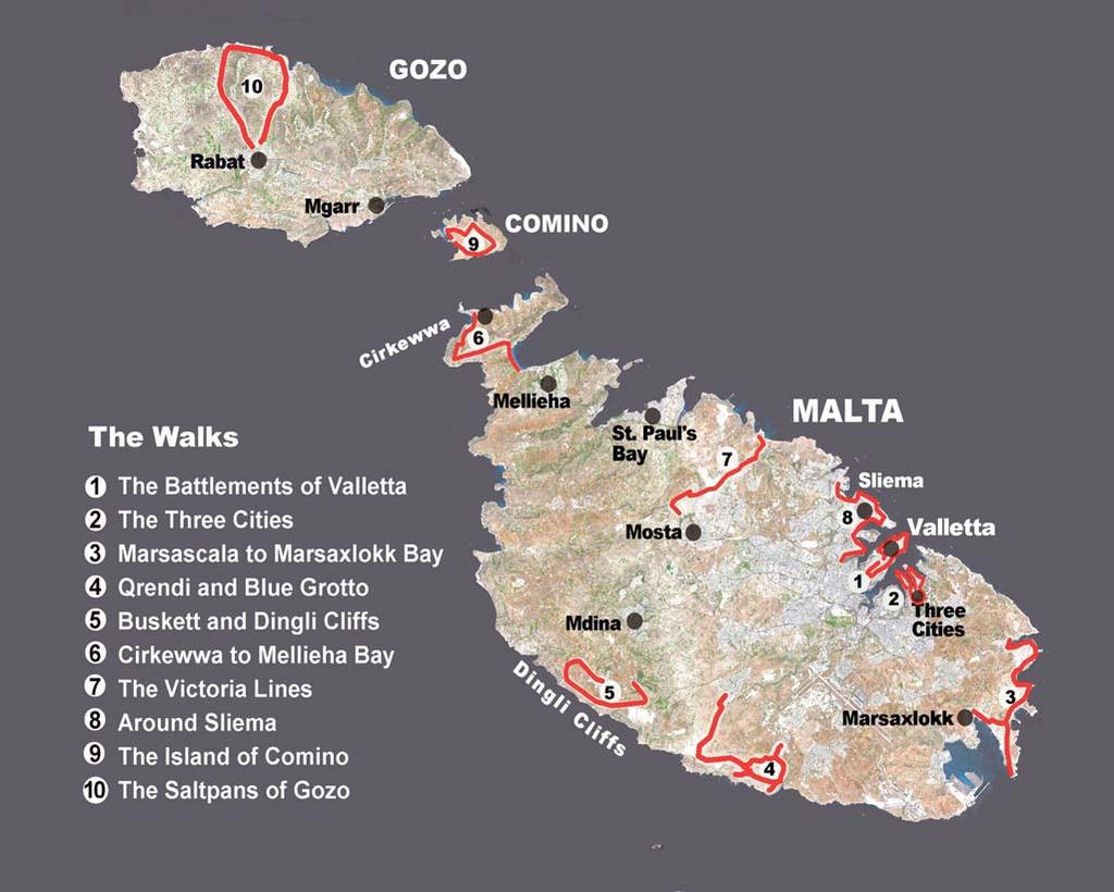
4 CONTENTS MALTA 10 GREAT WALKS Emmet McMahon and Jonathan Henwood Foreword 2 Introduction 3 A very short history of Malta 5 Geology and Wildlife 7 Buses and Ferries 9 THE WALKS 1 The Battlements of Valletta 11 2 The Three Cities 22 3 Marsascala to Marsaxlokk Bay 31 4 Qrendi and the Blue Grotto 38 5 Buskett and Dingli Cliffs 47 6 Cirkewwa to Mellieha Bay 55 7 The Victoria Lines 63 8 Around Sliema 72 9 The Island of Comino The Saltpans of Gozo 88 We would appreciate feedback on this book, including suggestions and corrections. Please send comments and any enquiries to our web site: 1

5 FOREWORD by the Hon. Dr Mario de Marco Parliamentary Secretary for Tourism, the Environment and Culture The Maltese Islands are a well-known destination with unique cultural and natural features, which witness to the diverse history which has moulded them. Although already a popular destination for their sun and clear waters, interest in Malta s lesser known features has been steadily increasing. Amongst these are the numerous diving destinations and rambling as a form of recreation through the urban and natural pockets of the Islands. Thanks to various initiatives by NGOs, Local Councils and the Malta Tourism Authority, as well as the increasing range of publications such as this book, Malta s appeal to local and foreign ramblers is being publicised widely and a niche tourism is helping to contribute to an in-depth appreciation of the forces which have shaped the land and the culture in which we live. Such initiatives also help us in our efforts to promote sustainable use of our limited landmass, and will therefore enable us to pass on a better country to future generations. This book presents a number of interesting walks which meander along some less known paths, to lead you to an appreciation of the human history of Malta through architecture, whether archaeological, military, vernacular or modern, and the natural forces of which have shaped the geology and the species which reside here. Each path is a unique journey with a number of surprising finds, fascinating landscapes and magnificent views, intricate architecture and a variety of biodiversity and geological features. I am confident you will enjoy each path as a new experience to be relished. 2
6
7 INTRODUCTION This book is aimed at readers who like walking, not just as a form of exercise, but also because of the places and people of interest to be encountered along the way. While not widely known for its walking potential Malta provides a wide range of enjoyable walks incorporating impressive historical, cultural, landscape and environmental features. Malta is quite compact so that on any one walk you can encounter a variety of sites. This book provides details of 10 great walks in Malta, together with a description of the noteworthy features that lie along each route. The duration of each walk is typically three to four hours and most can be shortened or extended to suit particular interests and circumstances. The starting and end points of each walk can be accessed by bus, as can every village in Malta. The book includes a detailed map for each walk and also describes the context (historical, cultural, environmental) of the key points of interest. The locations of the walks are shown on the overall map on the previous page, with more detailed routes given in later sections. Three of the walks pass through urban coastal areas, while the others are through areas that are primarily coastal and rural. Only one walk does not pass by a church. The walks we describe are as follows: Walk 1 The Battlements of Valletta Walk 2 The Three Cities Walk 3 Marsascala to Marsaxlokk Bay Walk 4 Qrendi and the Blue Grotto Walk 5 Buskett and Dingli Cliffs Walk 6 Cirkewwa to Mellieha Walk 7 The Victoria Lines Walk 8 Around Sliema Walk 9 The Island of Comino Walk 10 The Saltpans of Gozo OUR FAVOURITES? Cirkewwa to Mellieha (Walk 6) because of its world class landscapes and outstanding natural habitats, the Battlements of Valletta (Walk 1) for the number and diversity of historic features and Comino (Walk 9) for its Blue Lagoon, wild plants, and sense of isolation and times past. 3

8 INTRODUCTION As fully accurate maps of walking routes in Malta are not available and as paths are not always clearly signposted, you may often have to use your own judgement about minor details or suitable short cuts. Google Earth can help to give a good appreciation of the route, its features and options for walking paths. You can always ask the locals for help: they are friendly and English is very widely spoken as an official language. Walking in Malta may not be very pleasant during the hot summer months of mid-june to mid-september and walks during these months are best done in the early morning or in the evening. Remember to bring water, a hat and sunscreen. A pair of simple trainers is all that is required for footwear while a lightweight jacket should be carried in winter and in spring. While Malta has a good climate, the weather can sometimes be windy, cold and wet. On such days it is better to walk in Valletta, the Three Cities, Sliema or Mdina. Have a look at the weather forecast before you plan your walk; most hotels will have this at the reception desk. Alternatively consult which provides a detailed 5-day forecast. Some of the walks bring you near, but not very near, to cliffs. You must know by now that it is unwise to go very close to a cliff edge, particularly in windy conditions (and Malta can at times be very windy!) It is best not to walk alone near cliffs and to bring a mobile phone with you. If you are planning an evening walk during the hot season, be sure to allow enough time to be back before dark. Respect the environment bring back your own litter and do not pick or damage plants or flowers, as some are very rare. 4
9 INTRODUCTION A VERY SHORT HISTORY OF MALTA The State of Malta consists of three inhabited islands Malta, Gozo and Comino and a few uninhabited islets. Malta is the largest island, about thirty kilometres long by fourteen wide, while Gozo is fourteen by seven. With a population of about 400,000 Malta is among the most densely populated countries in the world. The island of Malta contains the capital, Valletta and the major centres of tourist and commercial activity. Gozo by contrast is a more tranquil island with an agricultural base and a more traditional approach to life. KEY DATES 5000 BC First settlers arrive in Malta BC Construction of Megalithic temples BC Roman rule 60 AD St. Paul shipwrecked on Malta Byzantine rule Arab rule Norman rule Swabian, Angevin and Spanish rule 1530 Malta ceded to Knights of St John 1565 The Great Siege, Ottoman army repulsed 1566 Foundation of Valletta 1798 French forces capture Malta and expel Knights 1800 French expelled, British rule commences German/Italian forces lay siege to Malta 1964 Malta gains independence 2004 Malta joins EU 5
10 INTRODUCTION Malta is fascinating because of its history, cultural heritage and natural environment. It has been inhabited from the earliest times and possesses many stone-age monuments (among the best in the world). The Phoenicians, Romans, Byzantines, Saracens, Normans and Spanish ruled the islands until 1530, when ownership passed to the Knights of St John. Malta has a strategic importance due to its location, a great natural harbour and easily worked stone. The knights exploited these advantages to make Malta into a fortress on the front line between the Christian and Muslim worlds. In 1565 Turkish troops of the Ottoman Empire (the superpower at the time) attacked Malta with a seemingly irresistible force. The outnumbered knights (supported by the Maltese) defended the island heroically and successfully. After the stressful start, the rule of the knights (now proudly renamed the Knights of Malta) proved a golden age as evidenced by the many treasures still to be seen - palaces, churches, gardens, paintings, sculptures and Valletta, a U.N. world heritage city. In addition, by building a university, schools and libraries, the knights initiated a tradition of learning and culture which is still evident in the high educational level of the modern Maltese. In their early days the knights were true Christian warriors and hospitallers and enjoyed wide support among the Maltese people. By the end of the 18th century however their moral practices had declined (and included the taking of mistresses). In addition, the knights became viewed as a privileged class, particularly by not admitting Maltese to the Order. The knights were expelled by French forces when Napoleon captured the island in After the English victory over the French in the Napoleonic Wars the Maltese did not wish to have the island again under the rule of the knights and in 1800, at the request of the Maltese, Malta became a Crown Colony under a benevolent British administration. Malta played an important military and commercial role within the British Empire, particularly after the opening of the Suez Canal. During the Second World War it was an unsinkable aircraft carrier and withstood a ferocious siege of almost two years by German and Italian forces. The importance of the island to the war effort and the courage of its defenders were recognised officially when the island was awarded the St George s Medal by the King of England. Malta opted for independence in 1974 but remains a member of the Commonwealth with many links to the UK Its long series of rulers have contributed to a varied and rich cultural legacy that is unsurpassed in any other small country. The island endured two dramatic sieges (1565 against the Turks, 1941/43 against the German/Italian forces) which were of great importance, not just to Malta but to all of Europe. 6

11 INTRODUCTION GEOLOGY AND WILDLIFE The Maltese islands are situated about ninety kilometres south of Sicily and two hundred and ninety kilometres north of Africa. The warm Mediterranean climate, its physical isolation from other land masses and its limestone base, have led to the formation of rare eco-systems with endemic species of plants and animals. Malta is now very urbanised and more than three quarters of the land is dedicated to human use. The island s rocks are of sedimentary limestone which started to form some 200 million years ago through the compaction of shells, coral, sediment and other material that fell to the sea bed. Five distinct layers can be distinguished, with each layer representing a different phase of development of the Mediterranean Sea and its inhabitants, and showing an interesting timeline of events, including drying up of the sea. The various layers can be seen at a number of cliffs (for example near Cirkewwa (Walk 6). From top to bottom (and from young to old) the five layers are as follows: Upper Coralline Limestone (a strong coral material used for concrete), Greensands (no particular use), Blue Clay (which has a significance for creation of springs), Globigerina Limestone (a yellow stone easy to carve, yet strong enough for construction) and Lower Coralline Limestone (the strongest rock of all, used in construction). Fossils such as shark teeth and sea urchins are to be seen at several locations but most obviously near the spectacular Azure Window in Gozo. It was the availability of readily quarried yellow Globigerina limestone that has given Malta such an abundant stock of quality and attractive stone buildings. Malta emerged from the sea floor around 8 million years ago and has since been moulded by tectonic activity, sea, wind, rain and humans, to create a rare geomorphology and landscape. A number of valleys, flooded by a rise in sea level, have formed spectacular bays, such as the Grand Harbour. The north and southwestern coasts of Malta and Gozo are dominated by impressive sea cliffs with numerous large sea caves. Other features which provide valuable habitats for wildlife 7

 PLANTS, ANIMALS AND BIRDS The flora of the islands is a rich mix of Mediterranean and North African elements and includes both endemic and introduced species.")
12 INTRODUCTION include dolines (collapsed caves), clay slopes, boulder screes and exposed surface limestone with shallow soil cover, known as garrigue. Garrigue, where fractured surface limestone hosts a variety of plants in shallow soil, is an important but under-appreciated habitat that you will encounter on several of the walks. Garrigue vegetation is low and usually comprises aromatic shrubs such as thyme, Mediterranean heath, spurges, together with a wide range of other plants. Wild Thyme ( PLANTS, ANIMALS AND BIRDS The flora of the islands is a rich mix of Mediterranean and North African elements and includes both endemic and introduced species. At times of low sea level (during the last ice-age) Malta had a land connection to Sicily which allowed the free movement of plants and animals and provided a refuge for certain European plants which prefer warmer climates. The introduction of both plant and animal species by humans (whether intentional or not) has also contributed to the biodiversity of Malta. Cape Sorrel, easily recognised through its yellow flowers, was introduced to Malta in 1811 as a garden flower while the Prickly Pear cactus arrived from California around the end of the 19th century. The overall result is that Malta hosts over 1100 wild plant species, around 146 of which are not found anywhere else and many of which are endangered. Wild flowers are one of the delights of walking in the countryside in Malta, particularly in Gozo in springtime. If you are especially interested in the plants and wildlife of Malta you should consider taking part in one of the escorted walks offered on These tours are accompanied by experts who can transport you to the best sites on the islands and give thorough explanations of the flora and fauna encountered. Because of its island status and small size Malta has only a limited number of mammals. The native species include several types of bats and a sub-species of the Sicilian shrew. Many of the country s mammals, such as the Algerian hedgehog, Mediterranean chameleon, Etruscan shrew, and weasel, have been introduced by man. The 8

13 INTRODUCTION rabbit, a Maltese favourite dish, was introduced by the Phoenicians about 3,000 B.C. There are a number of sub-species of lizards - one each for Malta, Gozo and Comino and others for islets such as Cominotto and Filfla. They originally comprised a single species but have since diverged somewhat through evolutionary pressure in their isolated locations. There are also two species of geckos and four of snakes, including the Leopard Snake - mentioned in the Bible as biting St Paul on his arrival in Malta. The islands of Malta consist of a dry limestone habitat with few forested areas and no permanent rivers or lakes. As a consequence the islands have as few as 21 regularly breeding bird species; these include species such as the Shorttoed Lark and the Blue Rock Thrush (the Maltese national bird). A contributory factor to these small numbers has undoubtedly been that, historically, trapping and shooting of birds, particularly migrants, was a major pastime. Since joining the EU, these activities have been significantly curtailed in compliance with the EU Birds Directive and recently there has been a recorded increase in both the numbers and species of breeding birds. As the islands occupy a strategic point on the migration flyway between Africa and Europe they play host to an impressive list of spring (March to May) and autumn (September to November) passage migrants. In all, some 384 species have been recorded to date and of which at least 170 are regularly recorded. Qawra (near St Paul s Bay) is regarded as one of the best locations for watching sea birds while Buskett, a small woodland area near Dingli, is noted for birds of prey such as the Honey Buzzard and Eleanora s Falcon. Only limited wetland and salt marsh areas remain in Malta and these provide important stop-over points for migrants such as herons, grebes, etc. while also supporting some breeding birds. The more important of these, Ghadira Nature Reserve in Mellieha and Is-Simar in Xemxija, enjoy full legal protection. Birdlife Malta, provides useful visitor information at Ghadira Nature Reserve

14 . BUSES AND FERRIES There are no longer any trains in Malta but the bus service is extensive, frequent, cheap and often fun. Some of the outlying villages, however, can have a very limited service, particularly in the evening. The buses, yellow with an orange band, are a collection of different models and hybrids. Some were locally built; others were imported second hand from the UK many years ago. Some more recent buses (the King Long) are of Chinese origin. They may not always be very comfortable but the eccentric character of many of the old buses more than compensates. The driver s corner is often enlivened by an eclectic variety of images and slogans. Photos of Elvis, flags for Manchester United and statues of Our Lady of Lourdes give a personalised touch so absent in northern European countries. All bus routes currently start and terminate at one of the three terminals in Malta: Valletta, Sliema and Bugibba/St Paul s Bay. There is also a small terminal in Victoria, capital of Gozo, but the service there is quite limited because of the relatively small population and the difficult topography of that small rocky island. Tickets for individual journeys can be purchased on the bus while multiple day tickets are also available. Full details of the bus service, including routes and schedules can be found through the website of the Maltese Transport Authority at Taxis can prove quite expensive. As the meter is rarely brought into use it is normally best to agree a price in advance of taking the journey. Taxis are most useful in the late evening when bus services are limited or for a group of travellers who can share the cost. There is an excellent ferry service to Gozo. This departs from the port of Cirkewwa in Malta to Mgarr in Gozo, a pleasant trip of some 25 minutes. Ferries depart about every 45 minutes in summer, with a somewhat reduced frequency off-season. The service operates every day from early to late although rough weather can infrequently lead to some delays and cancellations. The ferry takes both cars and foot passengers. Details can be found at Buses connect with the ferry at Cirkewwa and at Mgarr in Gozo. 10
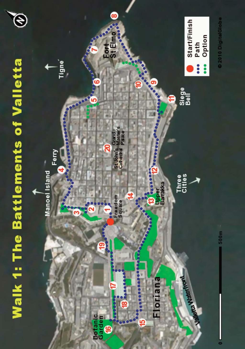
15 WALK ONE THE BATTLEMENTS OF VALLETTA This easy, extremely interesting and at times exciting walk begins and ends at the Gate of Valletta. It passes around, on top of, and outside the historic and imposing battlements which form the perimeter of the beautiful city of Valletta. The walk provides a panorama across the entire island from the high walls of Hastings Garden and stunning views from sea level of the breakwater to World War II defences at the entrance to the Grand Harbour. The section of this walk at sea level outside the battlements is not well-known even among Maltese people and you will meet few, if any, fellow walkers. The walk also takes you through Floriana, a suburb of Valletta with many historical features and the lovely Argotti Botanic Gardens. The walk done briskly takes about 3 hours but is best made into a full day trip to allow time for lingering over the magnificent views or visiting some of the many cafés, palaces, museums, gardens and churches along the route. Be sure to bring a camera and avoid the walk in stormy weather as the section at sea level is very exposed. CONTEXT Valletta, capital of Malta, ( a city built by gentlemen for gentlemen ), is a UNESCO World Heritage Site and deservedly so. Though there were losses from bombing in the Second World War it still retains immense cultural and architectural resources. It is situated on a peninsula overlooking the Grand Harbour, one of the greatest and most impressive harbours of the world. The Knights of Malta commenced its construction in 1580 shortly after the defeat of the Turks in the first great siege of Malta. The knights decided they needed a stronger and better base and so they undertook the construction of a great new city - Valletta, named after their Grand Master and hero of the siege, Jean Parisot de La Valette. The knights were members of the richest families of Europe and finance was not a constraint, more so since the Pope also contributed. A main design requirement for the city was the ability to withstand another sea and land siege and thus the leading architects of Europe were employed in its design and construction. Valletta is still completely surrounded by walls of a staggering size, extent and beauty, although they have been breached in some places to create new entrances for commerce and residents. It was the continuing influx of wealth and taste from continental Europe that created a culturally and architecturally advanced society on that previously poor 11
16 WALK 1 island. For the next 250 years or so, under the generally benign rule of the knights, Malta enjoyed an age of peace and prosperity. There are excellent buildings throughout Malta, but Valletta is exceptional in that it has so many fine churches, museums, palaces, auberges and historic buildings, all within a well preserved walled city. Go there! The size and street layout make exploration on foot extremely easy. The Great Siege of 1565 The seaward tip of Valletta is dominated by Fort St Elmo. It was here in 1565 that the knights made a glorious stand against the forces of Suleiman the Magnificent (also known as Sultan of the Ottomans, Allah s deputy on earth, Emperor of the East and West and Prince and Lord of the Most Happy Constellation). The knights had always been a nuisance to Suleiman as they harried his merchant vessels passing through the narrow channel between Sicily and Africa. The knights made a serious mistake around 1562 when they captured a large merchant vessel carrying luxuries from Venice to Constantinople. Not only was the boat owned by the head Eunuch, but important members of the Sultan s harem had made an investment in the cargo. The vigorous complaints of the ladies, combined with the prompting of his generals, encouraged Suleiman to order the invasion of Malta. Suleiman was a formidable enemy at the peak of his power, and his army, the most powerful in the world at that time, had captured Aden, Algiers, Baghdad, Belgrade and Bucharest and had even reached the walls of Vienna. The knights numbered about 700 and had perhaps 7,000 soldiers (many of which were untrained Maltese) to defend the island. The clever money would have been bet on a quick victory for the Sultan. Returning the ship and its cargo to the ladies, with an apology, would have seemed an appropriate response by the knights when their spies informed them of the Sultan s decision to invade Malta. Never ones to avoid a fight, however, the knights set about improving the defences of Fort St Elmo and their main base at Fort St Angelo, across the Grand Harbour from the then uninhabited peninsula of Valletta. Shore at Fort St Elmo
17 WALK 1 The Turkish fleet of 180 ships, with about 48,000 soldiers and sailors, arrived in May 1565 and quickly identified the Grand Harbour as its preferred anchorage. The entrance to the Harbour was however protected by Fort St Elmo. Turkish spies had reported that the fort had been built in some haste just a few years previously and that it had a number of weaknesses, in particular because it was overlooked by higher ground. The Turks set up 14 massive siege guns on the high ground of the peninsula and in May 1565 commenced their fierce barrage. The Turks expected the fort to fall within a week, but the courageous defenders held out for 31 days, as La Valette had ordered them to fight to the last. The knights lost around 1,200 troops, including 120 knights, while the Turks lost about 8,000 men on what should have been only a quick sideshow to the main siege of the knight s base in Fort St Angelo. Perhaps in anticipation of the screenplay of a Hollywood film, the Turkish commander Mustapha Pasha is reported to have cried out Allah, if so small a son has cost us so dear, what price shall we pay for so large a father? Whatever his exact words, it is clear that he then ordered that no prisoners were to be taken and that the captured defenders were to be put to the sword. Bodies of the knights, some living, most dead, were mutilated, tied to wooden crosses and floated across on the tide to the Christian forces. If this was intended to break the morale of the Knights, it was not successful. In response, La Valette ordered the killing of all Turkish prisoners, with their heads being shot by cannon into the Turkish lines. The message was clear this was to be a fight to the end. The action then moved across the Grand Harbour to a siege of the Three Cities, the area which is the subject of Walk 2. Valletta and the re-built Fort St Elmo have witnessed a number of historical events, including capture by French troops under Napoleon. The ousting of the French by the British was followed by a long period of prosperity (to which the dockyards and a large number of sailors bars are witness). The second great siege of Malta occurred during WW II when Italian and German airplanes, u- boats, torpedoes and the occasional attempted landing failed (barely) to capture the island. Valletta suffered greatly as it was the victim of frequent (even daily) air raids which still leave scars. Valletta and its people emerged victorious from the war thanks to the selfless effort of the lads of Operation Pedestal (fondly known by the Maltese as Santa Maria s Convoy), which carried food, fuel and other necessities through the dangerous waters of the Mediterranean to a hungry Maltese population and beleaguered British troops. 13
18 WALK 1 THE WALK The route is shown on Map 1. This walk begins at the Gate of Valletta, a disappointing entrance to a wonderful city. You will be glad to hear that it is about to be redeveloped to a design by the famous Italian architect Renzo Piano. This will give the city the stylish entrance which it once possessed, and which it deserves. Begin the walk by passing through the Gate of Valletta and into Freedom Square (1). Note the Opera House across the square which was bombed in 1942 and remains a ruin. The Maltese are not known for rushing things and generally prefer the Eurovision song contest to Opera, though some would argue there is not much difference. Turn left at the Café Royale, go down Ordnance Street and take the first turn left before the fort known as St John Cavalier (2). You will see Hastings Garden (3) about 50 m uphill named after a former Governor, the Marques of Hastings. Go into the pleasant garden, notice the thickness of the walls at about 6 m and look around at the impressive fortifications. The knights had lost the island of Rhodes to a Turkish siege, and nearly lost Malta, so they clearly knew a thing or two about defence. You will now readily believe that these battlements are the strongest, longest and most impressive medieval defence walls in the world. The view from the walls across the country is astounding you can see Mdina (the old capital) in profile and the radar dome that is situated on the Dingli cliffs on the opposite coast of Malta. As you walk along the park you can see Msida creek and its marina, Sliema, Manoel Island and Marsamxett harbour. The restored Fort on Manoel Island is particularly impressive. Walk to the right along the garden, leaving by the last gate and passing into a car park in front of a row of beautiful period houses. Pass on the left into the lower car park and exit onto the public road. Continue downhill to the left; you are heading down to sea level along a series of steps and after passing under a bridge you will find yourself at the jetty for the Sliema ferry (4). The ferry service to Sliema operates about every 40 minutes and is a great and inexpensive way of taking a short sea trip. Take the path past the water polo pitch (a popular summer sport) towards the tip of the peninsula. As you walk you can see many cuttings in the natural rock wall supporting the battlements, most of which are sealed by doors. These were air raid shelters cut from the rock by the citizens of Valletta during the Second World War. Many were owned 14
19
20 WALK 1 by separate families, some had several rooms. With an air raid virtually every day for 18 months it was important for the citizens to have a nearby shelter. The shelters here and in other towns were responsible for limiting the number of civilian casualties to a relatively small number in proportion to the very large number of bombs that were dropped. Note the impressive spire of the Anglican St Paul s Cathedral dominating the narrow streets above you. Walking along the coast you can remark on the unusual shapes of the windswept limestone wall. After a few minutes you reach a large entrance tunnel to the right, known as the Jew s Sally Port (5). Go through the tunnel for a few minutes to get a glimpse of narrow streets which make few concessions to modernity. External air conditioning units were a trend in Valletta that has now been banned. Waste collection is a challenge as there is not enough room for bins, and rubbish bags have to be left out in narrow streets for the daily collection. As there are few lifts in the old buildings, ropes and pulleys are sometimes used to get deliveries such as bread and groceries up to the higher floors. The washing hanging out of windows, the variety of smells and noises and the small shops all combine to give the ambience of a crowded medieval city. Continue the walk along the coast, passing by boathouses (6) converted into summer/holiday homes built alongside the inlet for small boats. The population density of Malta and the high summer temperatures mean that some Maltese seek cooler temporary abodes for summer living. Across the water you have a good view of Sliema and the Tigne Peninsula and among the new high rise development you can just distinguish Fort Tigne. Fort St Elmo Walk around the seaward tip of Valletta underneath the seemingly impregnable walls of Fort St Elmo (7). These mighty ramparts were designed to serve both as a physical obstacle and a visible deterrent. The original fort (built around 1560) was completely destroyed during the Turkish siege that so nearly ended the rule of the knights. It was re-built quickly as part of the necessary defences of Valletta and modified over the following centuries in response to changing military tactics and weapons. It played an important role in the defence of the island against the German/Italian siege of the Second World War. Because of 16

21 WALK 1 its strategic location at the mouth of the harbour, it was a perfect location for anti-aircraft guns and the obvious target of numerous attacks. You can still see the remains of the anti-aircraft gun emplacements. It was the guns on these ramparts that defeated the Italian e-boat attack on the Grand Harbour in Looking down at the limestone under your feet you can see many fossils, particularly razor shells. Passing around the tip of the peninsula you can see a number of steps leading to the remains of an iron bridge (8) destroyed by an e-boat during WW II. Walking up the steps you see the very impressive entrance to the Grand Harbour and a long breakwater with a lighthouse at the tip. The walk now becomes quite exciting as you turn a corner and unexpectedly meet narrow paths, small cliffs, caves and steps cut in the limestone rock. Note a number of air raid shelters dug into the rock and the numerous sentry points established during the Second World War to detect and deflect attacks by sea. You can appreciate the lengths to which the knights went to establish the outer walls of Valletta by looking at the arch over the small cove. After some more rock-cut steps and a small bridge, you come to an area of modest summer boathouses (9). Ascend to road level again using the adjacent steps to arrive on the upper road just opposite the original 17th century Knights hospital. This has now been magnificently renovated to create the Mediterranean Conference Centre (10). You can pay a fee to do a tour of the centre but for the moment just look in through the main door to get a glimpse of the scale and quality of the building. Turn right along the road to see Fort St. Elmo from the land side. During the French occupation in 1798 it was used as a prison while the British upgraded the Fort to house a series of coastal defence guns. Reenactments in period costume are held in the Fort every month and are well worth a visit. There are plans (as always) to restore Fort St Elmo but its scale would make this an expensive and long term challenge. In addition, there is always the problem of what use to make of it afterwards. 17
22 WALK 1 The Grand Harbour Turn back from St. Elmo and go along the coastal road until you come to the World War Siege Memorial (11). This impressive monument with its famous Siege Bell (rings at noon each day) overlooks the majestic Grand Harbour which was the scene of such horrendous conflicts and aerial battles. The monument is a memorial to those who lost their life in the second siege of Malta. Leaving the siege memorial, go straight across the road to Mediterranean Street and up to the peaceful Lower Barrakka Garden. At its centre is a small Greekstyle mausoleum in memory of Governor Sir Alexander Ball, who was in command of the successful defeat of the French in Continue the walk along the wall of the upper coast road, taking time to admire fleeting views of the narrow streets of Valletta which, as you see, is still very much a lived-in city. The pleasant walk, partly shaded by olive trees, passes beside some lovely balconies of pre-war houses. Continue on the path along the bastions, over Victoria Gate (12). The path rises as you walk up the steps in front of the British Hotel, then turn right and left to reach the Upper Barrakka Garden (13). This garden, the gift of an 18th century knight to the city of Valletta, is famous for its statues and its views, as well as being a pleasant spot for a coffee. Admire the panoramic view of the Three Cities on peninsulas across the harbour. You can see the large Fort St. Angelo, where the main action of the 1565 siege took place as the knights and almost the whole population of Malta sheltered within its battered walls. From this viewpoint you will understand why the Grand Harbour is regarded as one of the finest in the world, with deep water right up to the city s walls. You can see the shipyards and the docks which provide deepwater berthage and can appreciate the strategic value of the harbour which was capable of providing safe anchorage to the entire British Mediterranean fleet. This area was for over 12 months the most heavily bombed place in the world, with air raids a daily occurrence. Coming out of the Upper Barrakka Gardens, you will find yourself at a small square across the road from the Prime Minister s Office (14), the former Palace of the Knights of Castille. Note that the sentry is unarmed, which makes this possibly the only such office in the world without obvious armed protection. Also across the road is the St James Cavalier. This was one of the two main forts protecting the entrance to Valletta and it provided a further fall back position should invaders break through the outer defence walls. It has been sensitively 18

23 WALK 1 redeveloped as a cultural centre offering shows, films and exhibitions. Do not cross the road but stay on the footpath that leads downhill along the curving road. Look over the wall to note the very deep moat protecting the city. Rooms built into walls at the base of the moat provided a secure base from which the allies were able to plan the invasion of Sicily and Italy in Floriana Passing along the road out of Valletta, you enter the town of Floriana. The origins of Floriana date back to 1634 when, in anticipation of another attack by the Turks, the knights invited the Italian engineer Petro Floriani to advise on improvements to the defence of Valletta. On his recommendation, a system of new outer walls and bastions were built, with a length of over 4 km and with a number of gates and strong points. Passing along the west-facing walls of the city s outer defences, you overlook a small park and the liner berthing area (15). Malta is on the regular route for many Mediterranean cruises and receives at least one and sometimes three cruise liners each day. The thousands of visitors they discharge mostly go walking in Valletta and give an important earnings boost to the shops and tourist guides. The quayside where the liners pull up has recently been refurbished with fancy shops and restaurants catering for the wealthy tourist and some locals. The old stone buildings have been restored to their former glory and the area, rebranded as the Valletta Waterfront, is in the best possible taste. Walk down the central road through Floriana (St Anne Str) under the arches, until you come to the Lion s Fountain (the symbol of Floriana) (16) in the middle of the road, opposite the Chick-King café. To your left you can catch a glimpse of the Portes des Bombes, the outer Baroque gate of the Floriana defence lines. 19
24 WALK 1 Cross the road (there is an underpass 10 m back towards Valletta) and take the road directly opposite the fountain. Walking right from the Lion s Fountain, you pass by, on the left, a scout shop and an impressive Gothic-style Methodist church which has been turned into an old folks home. On the right is the small round Church of Sarria, built in The first church on this site was built in 1585 by the Knight de Sarria Navarro and was dedicated to sailors. Note the intricate fountain, one of several former fountains in the area. Go towards the Botanic Gardens (17). The site was originally developed in the 18th century as a private summer residence for Grand Master Pinto and was later laid out as a garden to the order of Bailiff Ignatius de Argote in In 1805, the British Governor appointed a Carmelite Friar as Malta s first Professor of Natural History. He had initially developed his plant collection in the nearby Mall garden and subsequently transferred it to this botanical garden. The gardens are divided into two main parts, a semi-private area (open during office hours only) and a public area. The former is controlled by the Curator of the Gardens and contains examples of endangered Maltese and Mediterranean plants of scientific interest. These include the Sandarac tree (Malta s national tree), the Ephedra tree (the only example remaining on the island), rare plants and medicinal herbs cultivated for botanical studies, and a large collection of cacti and succulent plants. This section also contains an exquisite gazebo dating back to 1741, which was formally decorated throughout with red coral and shells (a few pieces remain). It also contains the original summer residence of Grand Master Pinto, which is pleasantly cool in summer due to the garden shade. Amble around the attractive public section of the garden with seats, fountains, look-out points and a range of exotic plants, cacti and flower beds. There are a number of interesting water features and excellent views which overlook St. Philip s garden and the pine trees beyond the outer walls of Floriana. Exit the Botanic Gardens through the same gate by which you entered and walk to the left up to the nearby parish church with its impressive twin domes, keeping the Mall Garden (18) on the left. This area, known as Balzunetta, was famous around the time of the Second World War for its large number of sailors bars, best of which was reputedly the Flagship Music Hall, owned by a friendly lady called Zeza. The parish church of Floriana (19) is named after St Publius who was the dgovernor of Malta when St Paul was shipwrecked on the island in 60 AD It was 20

25 WALK 1 nearly all destroyed during the Second World War by a direct hit. However, as you can see, the Maltese were more eager to rebuild their churches than their Opera House. Publius converted to Christianity and went on to become Malta s first bishop and, as was to be expected, its first martyr. It was the influence of St Paul that left one of the island s most enduring characteristics the deep Christianity of its people. The Maltese are a Catholic people and their deep faith was untroubled by the reformation. The only alternative religion to which they were exposed was Islam. This was not attractive to the Maltese as they experienced it as victims of an aggressive expansionist empire. The large square in front of the church contains what appear to be the bases of Roman columns. These are the cap stones of former granaries, which are cylindrical wells carved vertically within the natural limestone. There are 76 of these, each capped with a solid circular stone, and they were used to store wheat up to the 1970s. The granaries were strategically located within the defensive walls so as to provide a food supply in the event of another siege. The square is now used for a variety of public meetings and Pope John Paul II spoke at St Publius Square during his two visits to Malta. It is worth spending a few minutes to go across to the right to see Middlesea House. It was in this building that Churchill met American President Roosevelt in January 1945 to prepare for their meeting in Yalta on the Black Sea with Stalin. It was at Yalta that agreement was reached to divide post-war Europe into spheres of influence of Russia and the West. Return across the square and walk through the linear park, heading towards Valletta. This now peaceful park was created by the Knights in the 18th century as a bowling green. You are now nearing the luxurious Phoenicia Hotel (20), one of the classic hotels of the British Empire. It has a beautiful lobby and retains some of the ambience of the colonial period. Return to the Gate of Valletta and be happy once again about its imminent reconstruction. We recommend that you finish off your walk by going into Valletta again to have a coffee or ice cream in the superbly beautiful interior of Café Cordina (21) in Republic Street. Afterwards you may wander around to admire such nearby architectural gems as S. John s Cathedral and the Grand Master s Palace. 21
26 WALK TWO THE THREE CITIES The Three Cities area, together with Mdina, is the oldest fortified settlement in Malta, and pre-dates the arrival of the knights in This very interesting walk through two of those old cities passes along narrow streets and coastal footpaths, and the sites of the Great Siege of 1565 and the fierce bombing of the Second World War. It features medieval street layouts, historic buildings, a great castle, extensive air raid shelters, harbour views, monuments, museums and churches. While the walk itself could be completed in 3 hours, it is best to allow a day for it so as to have time for visits to museums, etc. and lunch. You reach the start of the walk by bus from Valletta and have the pleasant option of returning to Valletta by bus or by boat. This is always an enjoyable walk but it is particularly inviting when the weather is cold, windy or rainy, as there are many places (churches, cafés, museums) which you can slip into for shelter and pleasure. CONTEXT Looking across the Grand Harbour from Valletta you can clearly see the small harbour cities of Vittoriosa, Senglea and Cospicua. These are also known respectively as Birgu, Isla and Bormla, and together they form the area of Cottonera. Confused? They are known more simply as the Three Cities and they played a critical role during the two great sieges of Malta. Though the Three Cities were heavily bombed during the Second World War, the area still contains many old and impressive buildings from the 16th century onwards. The cities are protected along the landward side by a massive line of fortifications known as the Cottonera Lines. This long high wall, reinforced with strong bastions, was constructed by the knights in the 17th century as an additional defence against a further Turkish attack. In 1522 the knights had lost the island of Rhodes to the Turks after a lengthy siege and were in need of a new base. The knights were originally a nursing order dedicated to the care of pilgrims visiting the Holy Land. The order had been based in Jerusalem but with its fall to Muslim forces in 1291 the Knights were forced to move, first to Cyprus and then, in 1310, to Rhodes. It was here that they developed their special characteristics of sailors, soldiers and hospitallers. Unable to pursue their war against the enemy on land they turned themselves into a formidable naval force. They were not at first attracted to Malta because (compared to Rhodes) it was a small rocky island with little fresh water, 22

27 WALK 2 wood or other resources. It had however that most important factor in real estate location and a great harbour. It was also the only island on offer to them, so in 1530 they accepted it from Emperor Charles V of Spain for the annual rent of one falcon. The local Maltese aristocracy was not too pleased at having new owners as they had hoped for more autonomy. However, many ordinary Maltese felt it would bring improved protection against the frequent raids by Muslim pirates in search of slaves. For that latter reason, the Maltese had established their capital at Mdina, the highest point in the island and several miles from the sea. The knights were a marine force and established their new capital at Birgu, a small fishing village across the Grand Harbour from the then uninhabited peninsula of Valletta. The adjoining port area of Marsa served as the base for the 30,000 strong army of Mustapha Pasha during the Great Siege in This was not a conscript army despatched to an unpopular foreign war. These troops were the premier units of the most powerful and successful army of the age. And they had come in their finery expecting another victory for the Ottoman Empire. The fleet consisted of 180 vessels, of which 130 were long-oared galleys and 30 were galliots, one of the larger vessels of the period which could carry up to 1,000 men. Eleven large merchant ships accompanied the armada, one of which alone carried 600 fighting men, 6,000 barrels of powder and 1,300 rounds of cannon ball. The knights on the other hand numbered about 700 and had perhaps 7,000 soldiers to defend the island. The peninsula of Birgu contained Fort St. Angelo, the main base of the knights, while the nearby peninsula of Senglea was protected by the smaller Fort St Michael. After their pyrrhic victory at Fort St Elmo, the Turks threw all their forces into the new attack and on 15 July a double attack, by sea and by land, was launched. This involved the transport of 100 small vessels by land across Mt Fort St Angelo Sciberras (where Valletta stands today) from Marsamxett Harbour, thus avoiding the cannons of Fort St. Angelo. This bloody attack was beaten back, but undeterred the Turks mounted 65 siege guns within striking distance of the walls and shot more than 100,000 cannon balls towards 23
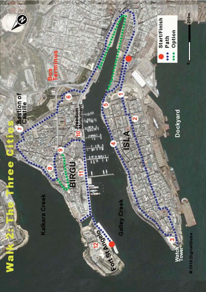
28 WALK 2 the cities. The siege, which lasted for two horrendous months, marked the transition between middle ages and modern warfare. While both sides had cannon and early rifles, most fighting was done hand to hand using traditional weapons such as swords, axes, spears and maces. The knights still wore armour which protected them against hand-held weapons, but not against musket and rifle fire. Birgu was nearly lost on several occasions when Turkish troops managed to break through the walls using contraptions such as siege towers or by infiltration through tunnels. On one critical occasion, when informed of a breakthrough by the Turks, Grandmaster La Valette (the leader of the knights) took up his sword and rushed to the battlefront to help repel the invaders. La Valette was wounded in the fighting but his troops rallied. The Turks were repelled, the breach sealed, La Valette survived and the siege continued. The history books tell us that on 8th September 1565 the Turks had broken through the defences and were within hours of capturing Fort St. Angelo, when word came through that Christian reinforcements had arrived from Sicily. Though the number of reinforcements (8,000 soldiers) would not have been sufficient to prevent an ultimate Turkish victory, it was sufficient to encourage the attackers to sound the retreat. The Turks were demoralised by their unexpectedly high losses and were anxious to sail back to Constantinople before the onset of autumn storms and dangerous seas. The bell that announced the lifting of the siege is still to be seen hanging from the highest point of the fort. The Turks fled from the island on 11th September 1565 and the people of Malta celebrated what turned out to be the last epic battle involving crusader knights. THE WALK The route is shown on Map 2. Take bus No. 3 from Valletta to Senglea (aka Isla) a journey of perhaps 25 minutes. Get off at the bus stop in the square just outside Isla and go uphill to enter through the city gate. Other buses to the Three Cities, such as 1, 4 and 6, will also take you very close to the starting point; ask the driver to let you off at Isla. On the way you will pass alongside the extensive dockyards and then through a tunnel under the impressive St Paul's Bastion, part of the outer defences of the Three Cities. Pass through the city gate (1) and take the central road leading to the tip of the peninsula, about 500 m away. The city of Senglea was set out on a grid pattern in 1551 by Grand Master De La Sengle but while the orderly street layout 24
29
30 WALK 2 remains, little is now left of the original town. You will notice that many of the buildings just inside the impressive entrance gate are of post-war construction because of destruction in the Second World War. You quickly come to the small square and the Parish Church of Our Lady of Victories (2). The original church of 1743 was destroyed in 1941 during an intense air attack on the aircraft carrier HMS Illustrious berthed nearby. The Feast of Our Lady of Victories falls on 8th September which is the same day that the Turkish forces abandoned the siege and the day when Italy surrendered to the allied forces in You can see why the Maltese have a particular devotion to Our Lady! There are few tourist cafés on this peninsula and it might be a good idea to have a coffee in a local club such as the Queen's Own Band Club. Such clubs play an important social role throughout the towns of Malta and allow locals, mostly men, to gather to drink tea or the local Cisk lager, play pool and engage in lively discussion on all sorts of subjects. The clubs are open to tourists and provide simple and cheap fare in a friendly atmosphere. As you walk further into the city you may take time to wander into side-streets which are characteristically narrow. To the left, you can see the dockyards which were a focus of the Axis bombing raids and, following the War, a great source of income. You will also notice a number of old buildings which escaped the bombing. A particularly important survivor is the 1662 Church of St Philip Neri. Pass around by the left of this church and then right until you come to a small garden (3) which provides a spectacular vista of the Grand Harbour, the docks, Valletta, the entrance to the Grand Harbour and Fort St Angelo. The sentry box at the tip of the peninsula displays symbols of watchfulness and good luck: the eye, the ear and the crane bird. The inscription in Latin assures the inhabitants that they may rest at ease as the tower is watching for their safety. During the Great Siege, a massive iron chain was drawn between Fort St Michael on this peninsula and Fort St Angelo across the intervening creek so as to prevent the entry of Turkish ships. The store from which the chain was drawn out can still be seen at sea level, on the Isla side, on the road below the garden. The creek is known as Galley Creek because the knights moored their boats here. Galley Creek Pass back out of the garden, go downwards on the left through steps and a tunnel, and turn right through a small square, staying above the coast road. Head along parallel to Galley Creek until, gaining a view of the water ahead, you descend along the steps to the promenade (4). On the way you will have admired the narrow streets and attractive houses that still retain a medieval 26

 for the unloading and servicing of the knights galleys.")
31 WALK 2 character. The promenade is a popular spot with locals who come to fish and relax in their boats, some of which are the traditional multicoloured Luzzus. As the promenade widens you will notice the blue painted monument to Colonel Juan Azopardo, a native of Isla who is honoured as the founder of the Argentinian Navy. Walk on, admiring the Birgu Waterfront on the other side of the Creek, past old barracks converted into residences until you reach a huge bastion (5), nowadays hollowed through to allow the passage of traffic. In earlier days it housed a large wooden crane (known as il-macina) for the unloading and servicing of the knights galleys. To reach Birgu (aka Vittoriosa) on the opposite peninsula you can sometimes walk directly along the quay in front of the old dock buildings. If there is no access on the day of your walk you must divert a little to the right and pass around by the public roads. The City of Birgu Birgu was protected by a massive wall with only one access point through a heavily defended gate. In recent times, however, a number of other entrances have been made through the wall to allow vehicle access. Fortunately (unlike Valletta) the original gate was retained and that is how you are going to enter the city. With Galley Creek to your left, walk towards Fort St Angelo. After perhaps 500 m, take the curving road to your right around a small roundabout and pass through the small parking area. You will see the original gate of the city (6) with a stone carving of cannons and the date in Latin letters, MDCCXXII (1722). Passing through the gate you enter a small square with a second gate, and behind this a third defensive gate. Note the thickness of the walls - this was serious stuff! Note that the fortifications were built out of the limestone rock from the site. The Malta at War Museum, located in the first square, has very interesting displays, mostly about the Second World 27
32 WALK 2 War. It is well worth a visit (but not right now) which includes a tour of the very extensive air-raid shelters that were hollowed out in the thick walls that you see around you. Passing through the second and third gates, go across the public road and take the first road to the right at the side of the fort known as St John's Cavalier. You enter a parking area between the battlements and a beautiful row of houses embellished with flowers and plants. You are going to wander along the walls to the right of the peninsula (as you face Valletta) overlooking Kalkara Creek, and there are a number of minor route options you can choose yourself, provided you keep to the general route. Go through the arch at the end of the car park and walk forward, entering the Bastion of Castille (7), briefly captured by the Turks in A plaque on the wall marks the spot where Grand Master La Valette was wounded in that battle. Coming out of the Bastion take one of the streets or lanes that lead you to the wall overlooking Kalkara Creek. Across the creek you can see old British Army buildings which served as hospitals during and after the Second World War. After walking on for about 200 m you will see, on the left, the Sacra Infermeria (8), the original hospital established by the knights in the mid 16th century. Attached to the building is a convent where Benedictine Nuns have lived since True to their strict vow of contemplation, the nuns never leave the convent. Victory Square Turn to the left at the end of this building up Triq il-miratur, then left on Triq Santa Skolastika and head to the city's central square, Victory Square (9). You may want to ramble a little up Triq Tabone (the street behind the Café du Brasilia) where the original auberges of the knights were located. They have been modified somewhat over the last 450 years and put to a variety of uses. The largest and most beautiful is the Auberge de France at No. 24. The former English auberge is used as the local library and council offices. Returning to the square, it is pleasant to take a coffee or a Kinnie (a local favourite) at the café and to look around from your outside table. The most striking building is that of the St Lawrence Band Club with its intricate facade. High on the wall on an opposite corner (with La Valette Str) is a medieval crucifix set into a wall behind protective glass. It was in front of this statue that condemned prisoners were allowed to recite their last prayers before being executed in the square, sometimes being burned at the stake! The statue of an effigy of Malta dressed in knight's armour is the Victory Monument which was erected in 1705 to 28
33 WALK 2 celebrate the outcome of the 1565 siege. The statue seems a bit modest and a bit late considering the great significance of that victory. Leave the square through the church yard which is to the left of the Victory Monument. This area was originally a graveyard for those who died during the Great Siege. To one side is the oratory of the Holy Crucifix (1721); to the other is the Oratory of St Joseph, which is now a museum containing the hat and sword of Grandmaster La Valette. Going downhill, you pass by the parish church of St Lawrence and the Freedom Monument to reach the side of Galley Creek. St Lawrence was an early Christian martyr who was roasted alive by order of the Roman Emperor Valeria. Today he is the patron saint of cooks! The church was already in existence before the arrival of the knights, but it was taken over, expanded and embellished by them. The church has a richly decorated interior and a variety of artistic treasures, including paintings and statues. The Freedom Monument (10) is near the quay where the last British military contingent departed from Malta in 1979, ending a connection of 180 years. Note the friendliness of the figures bidding each other farewell. Walking towards Fort St Angelo you pass alongside the well-maintained and busy modern marina. On the right is an imposing building that now houses the Maritime Museum, also worth a visit. The building was constructed as a bakery by the British in 1842 and it was regarded, as you can well believe, as the most beautiful bakery in the world. Just beyond the museum is the Casino di Venezia (11) which was formerly the Palace of the General of the Galleys. Take a look into the foyer to gain an appreciation of its exceptional beauty and style. An adjoining palace was unfortunately destroyed by World War II bombing. Other period buildings did survive and have been restored as part of the attractive development of this upmarket marina along the Birgu Waterfront. Fort St Angelo Before reaching Fort St Angelo (12) you cross over a moat that was hewn in the rock between the castle and the town. Its main function was defensive but it was also used for the berthing of vessels during rough weather or for minor repairs. The fort contains the original chambers where the Sacro Consiglio (Sacred Council) of knights met to discuss their war tactics, as well as dungeons for slaves and prisoners and a magnificent chapel dedicated to Our Lady of Victories. It has of course its very own ghost stories about the grey and black ladies and the shrieks of the dying knights during the Great Siege. The fort was almost completely destroyed during the siege, but the Knights 29
34 WALK 2 repaired it quickly and continued to strengthen it until it reached its current size and layout in The man mainly responsible for the appearance of the fort was Colonel de Grunenberg, engineer to the King of Spain, whose design gave the fort a series of gun batteries aimed at controlling the entrance to the Grand Harbour. His coat of arms is to be seen over the gateway to the fort. The British made few alternations to the Fort and utilised it mainly for storage purposes because of its many underground bomb-proof magazines. Between 1912 and 1979 the fort served as the headquarters of the British Mediterranean fleet. It was bombed heavily during WW II, receiving 69 direct hits. It is surprising therefore to learn that many historic elements survived, including the 15th century Castellan House on the upper part of the fort. This is now occupied by the Sovereign Military Hospitaller Order of the Knights of St John of Jerusalem, of Rhodes and of Malta the successor organisation to the Knights of Malta. The walk ends with a return from the fort alongside the marina. As you come out of the marina entrance you may care to enquire about the price and availability of a water taxi to take you across the harbour to Valletta. Alternatively you may go by bus to Valletta, by walking to the bus terminus which is opposite the entrance gate to Birgu. If you are not in a hurry you should visit one of the museums. The Inquisitor's Palace which is near the entrance gate is particularly enthralling. Where else would you see a chastity belt? 30 View of Senglea
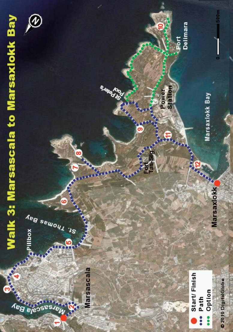
35 WALK THREE MARSASKALA TO MARSAXLOKK BAY This coastal walk from the town of Marsascala to the fishing village of Marsaxlokk provides wonderfully varied views of cliffs, bays, towns and tranquil countryside. The coastal limestone cliffs (some as white as those of Dover) have been eroded by rain, wind and waves to create a myriad of impressive shapes and structures. Features of interest you will encounter on the walk include ancient salt pans, a sandy beach, castles, fish farms, fishing boats, attractive countryside and, of course, some lovely churches. It is a longish walk, about 12 km say 4 hours, though it can be shortened by avoiding some of the tips of peninsulas. Bring your swimming trunks: you may want to take swim in one of the pleasant bays. There are cafés, shops and toilets along the first half of the route, but it is wise to take some water with you for the second half. Frequent buses will take you from Valletta to Marsascala and from Marsaxlokk to Valletta. CONTEXT The islands of Malta came into existence about 10 million years ago when the limestone rock of the sea bed was pushed upwards by tectonic plate movements. Further tectonic activity has created faults, ridges and rift valleys throughout the islands, while erosion by rain and sea has also contributed to a variety of landforms on quite a small land mass. Ice ages caused a drop in sea level and a temporary land connection to Italy, which allowed the free movement of animals, including elephants, hippos and deer, into Malta. These large animals eventually reduced in size (a common occurrence in animal species on small islands), as shown by the remains found in the Ghar Dhalam cave, just outside Marsaxlokk. The cave and its associated museum are open to visitors but do not form part of the walk. The limestone in Malta formed underwater from the remains of marine organisms and other sediments that slowly accumulated on the seabed and which, over millions of years, became compacted into solid rock. The quality and strength of limestone depends on the nature and mix of silt, sand and types of marine creatures present at the time it was formed. As a consequence, limestone can vary in strength and colour from one location to another and will also vary with depth. Geologists recognise five main layers in the limestone of Malta. From top to bottom there is: upper coralline limestone, greensands, blue 31

36 WALK 3 clay, globigerina limestone and lower coralline limestone. In some cliff areas (such as at Dingli) all five of these layers can be distinguished. The most obvious layer is the yellow globigerina limestone which can be seen throughout Malta and which has been widely used in the construction of churches, houses and forts. Fossil shells can often be spotted in the limestone, particularly in the area of the Azure Window on Gozo. Softer layers such as the blue clay are prone to erosion by waves which leads to the collapse of overlying layers. The walk along the coast beyond St Thomas Bay will showcase a number of these limestone layers and the varied shapes formed by the erosion process. THE WALK The route is shown on Map 3. Take bus No.17 from Valletta to the town of Marsascala and begin the walk at the northern end of the promenade, near the parish church of St Anne (1) and its impressive bell tower. This narrow curving bay (more a creek really) provides safe anchorage for many small boats, without the need for a breakwater. The modern buildings facing the sea are attractive, if over-intensive, and the general impression is of a pleasant and peaceful seaside town. The houses in Marsascala, as in all the towns of Malta, are well-built and well-maintained and there are no obvious slums or large groups of poor houses in any part of the island. There are wealthy inhabitants, some of whom are tax exiles, but the great majority of the Maltese are middle class in terms of income, values and behaviour. While the local papers testify to some crime and social problems, the people of Malta do not seem stratified by income and co-exist happily without great barriers of wealth or social exclusion. Few foreign tourists come to Marsascala and its many shops and cafés cater mostly for day trippers from other parts of Malta. There are a variety of restaurants facing the promenade, including one serving Bulgarian food with excellent salads and fish. Follow the promenade around the bay. Before you pass over the road bridge (2) at the innermost part of the bay, you can see in the water attractive seaweed known as Sea Grass or Neptune Grass. Sea grass meadows are found in clean waters around the Maltese coast and are important as a nursery for young fish and small marine animals such as 32
37

38 WALK 3 crabs, shrimps and the impressive Noble Pen shell. Sea grass is also important as a wave breaker since extensive stretches absorb the power of waves before they impact the shore. During the winter season the dead strands float to the surface and are carried to shore by wind and waves to accumulate in mounds. The decaying organic material is important for beach invertebrates and is sometimes taken away to be used as bedding for horses or as a soil improver. At the inner part of the bay, on the land side of the bridge, there is a small, legally protected wetland. It is a modest reserve providing a safe home for ducks, birds, some plants which thrive in brackish water and the Killi Fish, an inhabitant of hyper-saline waters. Malta has only a few wildlife reserves because of the intense urbanisation of the island and the (until recently) limited interest of the general public and politicians in environmental issues. The Saltpans As you walk up along the curving promenade you will meet an extensive area of salt pans ( salini in Maltese) (3) cut into the limestone rock. The saltpans were dug in globigerina limestone and you can see some interesting formations and fossils along the coastline here. Salt pans are found in many places along the coasts of Malta and Gozo, with a large concentration to be seen along this route. Salini have been used since Roman times as a means of harvesting salt from the sea. Seawater is fed into the shallow depressions through a system of handdug channels and, after concentration and evaporation by wind and sun during the hot summer months, the white sea-salt can be collected, bagged and sold. The Maltese have in some areas gone to great lengths to cut channels for easy filling of reservoirs or to limit dilution of saltwater. The production process is very labour intensive and is therefore no longer commercially viable, although some sea-salt is still harvested near Marsalforn in Gozo (see Walk 10). Note the twin WW II pillboxes which served to protect the relatively accessible bay from invasion. At the tip of the peninsula you pass by the impressive St Thomas Tower (4) constructed by the knights shortly after the landing of 6,000 Turkish soldiers in Marsascala Bay in A wide, dry defensive ditch protects the tower and the sea-facing battery, 34 The Saltpans
39 WALK 3 formerly armed with cannons. Just beyond the now defunct Jerma Palace Hotel take the coastal path (passing between two small pillars) and head around the pillbox, down onto the shore and onwards to St Thomas Bay. Avoid the temptation to stay on the roadside path - it will also take you to the bay, but by a longer and less interesting route. Note the good quality of many of the houses in this area. St Thomas Bay After a few minutes you come to a popular bathing area and a well located café (5) overlooking pretty St Thomas Bay. Take a break here and perhaps buy some water and a snack as you will not meet another shop until you arrive at Marsaxlokk, about 2 hours away. The bay has a small pier and an attractive sandy beach much favoured in the summer months by the Maltese. The view ahead is dominated by the high chimney of the Delimara power station. Walking along the sandy beach you can see to the right a number of former boat houses converted into simple summer residences for family use. At the end of the bay take the narrow path heading uphill straight across the peninsula (6). Note the intensive erosion of the soft stone at this end of the beach. At the start of the path, to the left, you can see the remains of Batterija ta l-irhama (Marble Battery), a small coastal defence unit now in need of restoration. At the side of the path you can see many hunting hides and perches for caged birds which, in a practice now illegal, were used to lure wild birds for trapping by nets. Look around at the variety of plants beside the path, including the endemic Maltese salt tree, samphire, sea lavender and capers. The small buds of the wild caper are picked in early summer and, when pickled, make a tasty addition to salads and traditional Maltese sauces. On a fine day you will usually see some lizards and perhaps a snake, all of which are harmless to humans. At the high point of the path you can enjoy an outstanding view of attractive white cliffs. Out to sea you can notice some fish farms for sea bream and sea bass and some round pens for the fattening of tuna for export, principally to Japan. You can usually also notice container ships heading to, or leaving, the nearby busy Freeport in Marsaxlokk Bay. Walk along the path at the edge of the cliffs passing near the former relay station (7) for the German Deutsche Welle radio network, built in the 1970s. The site is now in the care of Nature Trust Malta, which is planning an afforestation project. 35
40 WALK 3 The path turns inland along a high wall on the left and leads to a chapel beside a fortified farmhouse. Fortified houses were common in the remoter parts of the island, which would otherwise have been at the mercy of Turkish invaders. Divert 100 m along the seaward path to the left to get a very spectacular view of caves, cliffs and bays formed from white limestone, an area (8) known as il-hofra (the Hole). Now turn back the way you came and follow the track inland to gain pleasant views of open countryside, with Marsaxlokk in the background. Go past the old Tas-Silg Fort which now serves as a sanctuary for homeless dogs. Where else in the world would there be a spare castle to devote to such a purpose? After passing the fort, turn to the left, going slightly uphill towards Delimara Point, and take the path to the left amongst the fields. After passing an old barracks building converted into a villa (9), take the path to St Peter's Pool, which is signposted. Admire again the various shapes of the limestone cliffs eroded by wind and waves and which are quite different from those you passed earlier. The rock here is tougher and forms more durable features such as sea caves and flat limestone pavements. Follow the narrow path around to St Peter's Pool where you might take a break and consider a swim. This small rocky inlet is popular with swimmers, snorkellers and fishermen after small fish and octopus. You have the option of making your way along the coastline until you reach the tip of Delimara peninsula, though the walk can be a little challenging at times. You may prefer to leave by the shorter path through the car park which brings you to a T-junction on the public road between Delimara Point and Marsaxlokk. You have an option here of turning to the left and walking to (and then back from) Delimara Point. This adds about 1 km but has a number of points of interest. The old lighthouse (10) at the tip of the peninsula is a fine example of Maltese construction. The impressive Fort Delimara was built by the British in 1881 to protect what you can see is the large and important Marsaxlokk Bay. Alternatively, if you are a little tired, you may turn immediately to your right to walk inland, with the power station to your left. You get an outstanding view of 36

41 WALK 3 Marsaxlokk Bay which is Malta s second largest natural harbour and the island s main fishing base. The sheltered bay was a convenient landing place for pirates, Ottoman soldiers and, in 1798, Napoleon s army. The bay is nowadays dominated by the activities of the commercially successful Freeport which provides extensive storage facilities for containers and fuel oil. The intensive shipping activity in the bay seems to co-exist happily with other uses such as fish farming, boating and leisure. Just beyond the power station take the first downward path to the left (11) and descend to the public (but little used) road which leads to Marsaxlokk village. Into Marsaxlokk Keeping to the left along the coast (where you can) you will pass by a small protected area (12), formerly a number of ponds used to fatten fish caught by local fishermen. After destruction in a storm the ponds were converted into a small wetland. You arrive shortly at the mooring area used by the fishing boats - a good place to see the colourful traditional fishing boats, the Luzzu, with an eye painted on the prow to bring good luck. A little further on, if it is a Sunday, you come to a busy market with stalls selling fish of varied shapes, colours and sizes. The range of fish includes octopus, morays, grouper, swordfish, sea bass and lampuki (dolphin fish), an important fish for a number of traditional dishes. The lampuki migrate past Malta in the autumn and are caught by a method known as kannizzati which has been in use since Roman times. Fishermen weave the fronds of palm trees into large rafts which are then pulled out to sea. Seeking shade during midday, the lampuki form schools underneath the rafts and are easily caught using a large mesh net. You can see a number of stalls selling a mixture of small fish such as bogue, wrasse and bream which are used for a Maltese fish soup called Aljotta. Most stalls sell universally available cheap Asian goods and are of limited interest to walkers. However you can buy t-shirts with such valuable messages as I will buy you a drink tomorrow. The town has a number of pleasant cafés and restaurants in which to relax before taking one of the frequent buses back to Valletta. You will not be surprised to learn that Marsaxlokk is reputedly the best village in Malta in which to enjoy a good fish dinner. 37

42 WALK FOUR QRENDI AND THE BLUE GROTTO This circular walk begins and ends at the historic village of Qrendi in the south east of Malta, but there is also the option of continuing onto the town of Siggiewi. The walk passes initially through pleasant countryside to reach spectacular coastal rock formations, the most famous of which is known as the Blue Grotto. The route then leads you to the magnificent megalithic temple complexes of Mnajdra and Hagar Qim which are designated World Heritage Sites. The walk also includes a visit to the splendidly verdant Maqluba doline a collapsed cave hosting a range of moisture loving plants. Also to be seen along the route are ancient churches, narrow village streets, small fields and romanticallysited defensive towers. The coastal area is rich in biodiversity and is of great scenic beauty It is a very pleasant walk, though it does include a steep (but safe) climb up from the Blue Grotto. The overall length of the basic walk is about 7 km but we recommend that you make it into a full day trip by visiting the Neolithic temples, or by taking a short boat trip at the Blue Grotto (weather permitting) or by continuing the walk to Siggiewi, an extra distance of about 5 km. Cafés and toilets are to be found at a number of points along the route. CONTEXT The southern towns such as Qrendi, Mqabba, Siggiewi and Zurrieq are more traditional and less visited than the towns of central and northern Malta, with industries such as agriculture and quarrying as major sources of employment. The local limestone is of prime quality and the general area is a hub of quarrying activity, as can be seen from the many quarries dotting the local countryside. The inhabitants have long been recognised as masters in stone cutting and shaping and the locality has supplied prime quality hardstone and softstone for building and decorating for many years. The Limestone Heritage Centre in Siggiewi (worth a visit) has a very interesting and enjoyable exhibition of the many uses to which limestone has been put. 38
43 WALK 4 Qrendi, with a population of some 2500, is a quaint and relaxed village where harmless gossip about the occasional tourist, local politics and village feasts is the daily norm. The narrow winding streets and the houses with impressive stone-carved balconies are typical of the general area. Qrendi contains a surprising number of ornate buildings including the baroque Parish church and the generously decorated facade of the Band Club. The locals take their festas, firework shows and street decorations seriously, with fierce competition between brass bands and fireworks factories. While the village dates back to the fourteenth century, evidence of habitation in the area goes back to around 3000 BC, as witnessed by the nearby stone-age temples of Mnajdra and Hagar Qim. These monuments, among the oldest free-standing structures in the world, are set in a garrigue area with fine views of the coast. Other remains such as ancient graves, catacombs, and prehistoric water reservoirs also testify to early settlement in this fertile region. The Temple Culture Modern archaeology has shown that on Malta, people without a written language or knowledge of metal had constructed large, highly sophisticated structures several hundred years before the Egyptians began work on the pyramids. The temple building period started around 3600 BC, while the earliest signs of human activity in Malta date back to about 5000 BC. The Stone Age Maltese built their temples singly or in groups, decorating and enlarging them during a period of over 1000 years. Their decorated interiors were originally thought to have been inspired by the great Greek civilizations of Crete and Mycenae, but it is now clear that Malta's temple culture had flourished and died before those Greek civilizations were born. The Temple culture came to a mysterious end around 2500 BC. It is not known whether these people died out or were absorbed by invaders from various parts of the Mediterranean during the Bronze Age. This walk includes a visit to the temple complexes of Mnajdra and Hagar Qim, which are among the largest and best preserved examples of this culture. Artefacts (such as the beautiful Venus of Malta) found during site excavation are to be seen in the National Archaeological Museum in Valletta. Following the Temple and the Bronze Ages the islands were ruled by various empires, each leaving an imprint, such as Punic tombs, Roman villas, and the Arab s contribution to the Maltese language. But it was the knights who left the dominant physical heritage. In the Qrendi area this includes the Chapel of St Anne built in gratitude for the victory in the Great Siege of There are seven churches and chapels in the parish, most built on the sites of earlier structures. 39
44 WALK 4 The knights also constructed an octagonal tower in Qrendi which housed a garrison for protection of the area, and a chain of look-out towers along the coast. During the Second World War Qrendi and its surrounds hosted garrisons of British troops in preparation for action against Rommel s forces in North Africa. Qrendi was also the site of an airstrip built for the Allied invasion of Sicily. Although it has now been mostly returned to farmland, the outline of the runway can still be seen (see Map 4). Because of the presence of the airstrip, Qrendi was bombed on a number of occasions. The coastal area hosts magnificent biodiversity on cliff faces, caves and valleys as their inaccessibility protects them from human interference. The cliffs and sea between the coastline and the small island of Filfla are legally protected areas because of their rare sea birds, wild plants and marine life (such as the rare green turtle). The coastline is battered by heavy winter storms and the coastal flora is typically composed of red crust algae, often with impressive deep red or pink colours which can withstand such storms. Fish such as the John Dory and morays, and other fauna such as starfish, limpets, dog worms and crabs, make their home among the expanses of algae, making this coast an excellent place for snorkelling and scuba diving. To further enhance the diving experience, the 10,000 ton ship Um El Faroud was scuttled here some years ago, about 150 m from the shore. The wreck has become an interesting dive site because of the number of amberjack, tuna, squid, barracuda and mullet attracted to this artificial reef. This ship is well known among Maltese because it exploded in 1998 during repair work at the Malta Dockyards, killing nine. THE WALK The route is shown on Map 4. Bus numbers 35, 38 and 138 from Valletta will take you to the starting point in Qrendi (there are no direct options from Sliema). Get off at the bus stop in the main square near the parish church. This tranquil town has no tourist cafés so you may take the opportunity to have a coffee or a Kinnie in the nearby Band Club café. The church (1), consecrated to the Assumption of Our Lady, was built in 1655 with some reconstruction in Near the Band Club you may notice a number of men passing their time in gossip on the benches. Take the narrow Triq il- Parrocca to the left of the church (as you face it) and past the public toilet. This will take you along a typical village street with a number of old houses and to a small square with a statue of St Matthew in the centre. From the opposite side 40
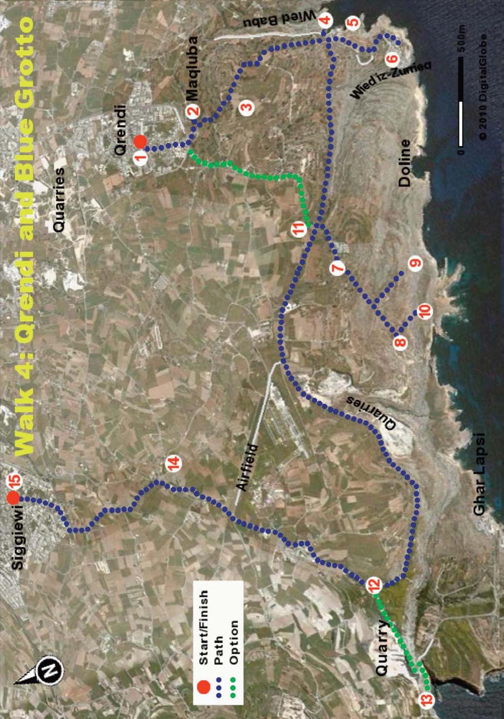
45

46 WALK 4 of the square take the straight downhill road to reach an open area with a number of gnarled carob trees. To the left, at the far end, you can see the Chapel of St Matthew (2), built in Originally this was two separate chapels which were later joined together. Walking towards the chapel you can notice that the facade is somewhat newer than the rest. This chapel was hit by a bomb during the Second World War and parts of the structure had to be rebuilt. The Doline To the left, you can see a large depression known as the Maqluba doline. This large hole, 60 m in diameter by 30 m deep, formed in 1343 when, on a stormy night, water gushing through a subterranean cave caused the roof to collapse. The cave had been silently forming for thousands of years through the erosion of soft limestone by slightly acidic rain water. The doline is nowadays a spectacular site and is a designated protected area. It hosts a variety of trees (such as the Sandarac) growing along the cliff faces, plants typical of humid areas, such as mosses and liverworts, which are rare in Malta and small birds such as robins and rock thrushes. Going down the steps, taking care not to slip as you pass carob trees and spiny smilax creepers. This is the lowest point in the area and receives runoff of rainwater from the village and surroundings so that it is always humid. Continue down the steps until you reach a viewing platform with an iron railing. From here you can see the cliff face covered with caper bushes, Maltese salt trees and sandarac trees. The bottom is rich in carob trees and reeds, a sign of soil fertility and water abundance. It is a good place to see the Blue Rock Thrush, Malta s national bird. On your way back up notice, to the left, a path carved out of stone leading to the bottom of the doline; this was used in earlier times to harvest water and reeds. 42 Once back on top, take the road immediately to the right of the chapel, heading away from the town. Proceed uphill, passing by attractive rubble walls and small fields with fertile red soil, rich in iron. The pleasant walk goes past, on the right, a fireworks factory

47 WALK 4 (3). When a red flag is hoisted, it indicates that the manufacture of fireworks is underway. Malta is famous for its fireworks displays and has won many international competitions. The manufacture of fireworks is a voluntary but dangerous hobby, with fireworks-related deaths an almost annual occurrence. After walking on for about 1 km the road widens and then goes steeply downwards to where you get a view of the open sea and, in the distance, the islet of Filfla. To the left you can see the valley of Wied Babu and, behind you, the town of Zurrieq. At the main road, cross over to the modern promenade and go to the left to arrive at steps leading down among spiny agave plants to a small garrigue garden (4). The garden is on the cliff edge and provides a spectacular view of the Blue Grotto. Note the rock arch that is shaped like a flying buttress in a medieval cathedral. Walking to the left along the garden wall you get varying views of the Blue Grotto and the impressive cliffs, with caves at sea level. The Blue Grotto, it is said, received its name from a British soldier who considered it similar to the famous rock feature on the Isle of Capri. Take your time to look at the beautiful views from the garden, including the steep sides of Wied Babu, a short dry valley formed by water rain seeping from the area around Zurrieq. The Blue Grotto The sea between the coastline at the Blue Grotto and the small island of Filfla was known as an important breeding ground for sharks such as the Hammerhead. What was claimed to be the world s largest Great White Shark (and later proved wrong) was caught off the coast here by a local fisherman in You may be comfortable to know that sharks are (unfortunately) no longer common due to over-fishing and former practices such as the use of explosives for fishing. The area is still well used by locals for non-commercial fishing, sometimes using traditional cone shaped wicker cages, and night-fishing. You may now undertake the worthwhile descent towards the Blue Grotto (5). Take the curving road downhill and after perhaps 100 m, the stony pathway to the left. This will lead you down to the coast where you will find cafés, souvenir shops and public toilets. You can admire the knight s tower and, a little further along, a garden which leads to a popular swimming and snorkelling area along the rocks (6). The water here is deep and clean and with the sun shining at the right angle, the 43

48 WALK 4 colour of the light reflecting from the underwater algae and rock surfaces is very beautiful. The caves and arches are best appreciated from the sea so if the weather is fine you should consider taking the offer of the short boat trip to view the nearby rock features. Afterwards you can have a coffee and a bite in one of the cafés, before taking the road uphill. Back at the top, take the main road (with the sea to your left), passing along the dry valley of Wied Hoxt and with wonderful views to Filfla. The garrigue in this area hosts a variety of plants, some of which are very rare. After about 1.5 km take the road junction to the left towards the car park of the new visitor centre and, to the right, a white dome sheltering the temples of Hagar Qim (7) from wind and rain. The Mnajdra temple (8) complex is nearby and one ticket allows you access to both. Hagar Qim and Mnajdra Hagar Qim (built between 3000 BC and 2500 BC) lies near the top of a hill and is built from soft globigerina limestone, while the nearby Mnajdra complex is built of harder coralline. Hagar Qim (meaning the Rocks of Adoration) is notable for its impressive and finely-smoothed entrance facade, for the huge stone blocks used in its construction, and for the artefacts found on the site: particularly the "Venus of Malta" and other statuettes. It is composed of a main temple and three additional sections probably older than the main temple itself. The temple has a forecourt and a facade with large corner-stone blocks and has a series of apses, some containing free-standing altars, pens for sacrificial animals, and an oracle hole. The Mnajdra complex is comprised of three adjacent temples, each with different uses, as revealed by the artifacts found on site. The lowest temple was 44
49 WALK 4 probably used for astronomical observation since it is aligned so that on the vernal and the autumnal equinox sunlight passes through the main doorway and lights up the major axis. On the solstices, sunlight illuminates the edges of megaliths to the left and right of this doorway. These temples are magnificent pieces of ancient engineering. The blocks, the largest estimated at 20 tonnes, had to be cut and shaped using primitive rock tools and then transported to the site from nearby quarries using sheer sweat and muscle and with the help of logs or rock spheres. On the path down to the Mnajdra temple you walk through garrigue which was pretty much the landscape around the time the temples were built. To the left you can catch a glimpse of Hamrija Tower (9) built by the knights in 1596, and a small simple stone memorial dedicated to General Sir Walter Congreve. The general served as a governor of Malta between 1924 and 1927 when he died. At his request, he was buried at sea in the channel between the coast and Filfla, now known as the Congreve Channel. Go down to the Congreve memorial (10) to get wonderful panoramic views of the rock formations along the high limestone cliffs and features such as another doline, and caves and natural arches at sea level. When you have finished your tour of the temple you should leave through the path by which you entered. Take the path upwards past Hagar Qim and out of the car park. You now have the option of returning to Qrendi (a walk of about 1.5 km) or continuing on to Siggiewi, about 6 km away. TO QRENDI: At the main road turn to the left and then take the smaller road immediately to the right, passing in front of an unusual old building (11). The path curves slightly upwards and leads, after around 1.5 km, to Qrendi village. After perhaps 1 km along this minor road, you pass on the right a simple yet magnificent palace flanked by two large palm trees at the entrance. This palace was built in 1735 by Fra Pier Guarena di Rovero, a wealthy and well known knight, as a fortified rural palace. It has a magnificent garden, but there is no public access as it is privately owned. After the palace the road goes downhill and comes to an ancient chapel dedicated to Our Lady of Graces. Take the road immediately in front of the chapel (not the smaller road further to the left) and walking straight on, through the cross roads, you reach Maqluba Square in Qrendi. Take the road to the left towards the Parish Church where you can catch a bus back to Valletta. 45

50 WALK 4 TO SIGGIEWI: Leaving the car park of Hagar Qim, turn to the left and walk along the main public road for about 2 km. The road curves towards the coast and you will see on the left a number of hardstone quarries surrounding a small valley known as Wied Maghlaq. This dry valley is rich in flora and has some interesting quaternary deposits, the red colour of which is due to iron. The general locality supports a number of orchids including the endemic Maltese Pyramidal Orchid and the very rare Naked Man orchid. Endemic rare beetles, ants and snails are also to be found. Further on you see the beautiful inlet of Ghar Lapsi, a popular bathing spot during summer months. The rocky coast here is excellent for snorkelling and the inlet makes a good entry point for divers. There are a few flat rocky ledges to lie on a towel, but no sandy beach. To the right of Ghar Lapsi you can see a Reverse Osmosis plant, one of three on the island for removing salt from seawater to make potable water. Further ahead you can see the start of the Dingli Cliffs near another large hardstone quarry. There is a Bronze Age village high on the hill above the quarry hidden from view. Continue walking until you reach a roundabout (12) and to your left, the winding road down to Ghar Lapsi. We suggest you go about 500 m down this road to gain a view of some spectacular cliffs (13). The walk down to Ghar Lapsi is not so long but the uphill return can be very tiring, so having admired the view you may prefer to turn around and go back up to the roundabout and head inland to Siggiewi, a distance of about 3 km. The route has a number of features of interest including chapels, niches, agricultural land and distant views of Mdina. On the left you will pass a 19th century aqueduct and behind it, on a hill, the Laferla cross, a popular pilgrimage place during Holy Week. Further on to the right you will see the Providenza Chapel (built 1750) (14), which is worth a short visit. As you approach the outskirts of Siggiewi follow the signs to the centre which direct you to the town square containing a statue of St Nicholas, a church and a chapel and cafés (15). You can catch a bus from the square to Valletta. 46
51 WALK FIVE BUSKETT AND DINGLI CLIFFS This walk near the south coast of Malta offers great diversity in terms of views, habitats and archaeological interest. It starts at the beautiful Buskett Gardens, the largest natural wooded area in Malta and of great ecological and historical significance. The walk leads you past Punic tombs, abandoned cave dwellings, a knight s palace, wild garrigue, a pleasant cliff-side restaurant and an area crossed by so many of the enigmatic prehistoric cart ruts that it has been named Clapham Junction. The panoramic views from the extensive Dingli cliffs are astounding. Buskett Gardens is very popular among locals for weekend recreation and so it is better to do this walk on a weekday. Its overall length is around 10 km, less than 4 hours, but the route can be extended should you wish, so as to make it a full day s event. The bus back from Dingli passes through Mdina so you could combine this walk with a pleasant coffee and stroll in that beautiful ancient capital. Binoculars will help you to enjoy the views, and, if migration is on, the many birds of prey which favour this area. Although the walk passes by the high Dingli cliffs the route is neither dangerous nor difficult and simple walking shoes will be adequate, but do bring adequate water and sun protection. CONTEXT Buskett ( the small forest ) is the largest expanse of deciduous woodland in Malta. To some tourists it may resemble a country estate but in highly urbanised Malta it is a unique haven for trees, birds, fungi and their enthusiasts. Woods with large trees are a rarity in Malta, not only because of its dry and windswept nature, but also due to human intervention. During colonisation of the islands by prehistoric humans the best areas of forest were cut down for brush and timber and to reveal soil deep enough for agriculture. Nowadays only a few remnants of natural forests survive in remote areas, such as Wardija, where some Holm Oak trees over 1000 years old can be found. More common are the maquis communities where bushes and small trees such as Hawthorn, Sandarac, Carob and Olive are the dominant species. In the late 16th century Grand Master La Valette converted this valley into woodland for hunting and falconry, and as an orchard. The gardens, planted during the period of Grand Master Lascaris ( ), are largely unchanged since that time. The gardens contain a diversity of habitats and features including 47

52 WALK 5 vineyards, orange and lemon groves, pathways with ivy-clad stone walls and centuries-old farmhouses. The gardens are extremely popular with families and at weekends they are alive with the sound of children playing and parents preparing picnics. This area hosts hardy native species capable of withstanding dry summers, such as Aleppo Pines, Holm Oaks, Cypress and Lentisk, together with some rarer species such as the White Poplar, which grows along the sides of the valley. From autumn to spring there is plenty of wildlife interest, which in addition to trees includes wild flowers, flowing water and associated fauna, and birds. Buskett is probably the best location in which to see birds of prey such as the Honey Buzzard, Short Toed Eagle and Eleanora s Falcon during the spring (March to May) and autumn (September to November) migrations between Africa and Europe. The wooded area of Buskett leads uphill to the more formal gardens of Verdala Palace which was built for Grand Master Verdalle in the late 16th century. Verdala Palace was the principal hunting lodge of the knights and allowed them to keep an eye on the Maltese nobles at Mdina, while entertaining themselves with the hunts and the women of nearby villages. Verdala served as a prison in 1800 when the French Napoleonic forces surrendered to the British but later fell into disrepair. It was brought back into use again in 1939 for storage of major works of art which were at risk in Valletta from German bombing. Following refurbishment, Verdala Palace is now used for important state celebrations, as a Government guest house for visiting Heads of State and as the official summer residence of the President of Malta. The palace boasts frescoed halls, elliptical staircases and its very own ghost stories. It is open to the public on certain dates. The path from Buskett to the Dingli cliffs takes you through a rocky garrigue area with interesting archaeological features including Roman quarries, rock-cut tombs from Carthaginian times, an extensive complex of cart ruts and the cavesettlement of Ghar il-kbir ( the Big Cave ), the best example of a troglodytic settlement (where people lived underground) in Malta. These caves were inhabited from ancient times until the early 19th century, when the more than one hundred inhabitants were forcibly evicted by the British administration to be resettled in the nearby villages of Dingli and Siggiewi. The cave complex was subsequently stripped bare of doors and furniture but the basic living arrangements can still be discerned. 48
53 WALK 5 THE WALK The route is shown on Map 5. Bus No. 81 from Valletta will take you to the starting point of this walk, passing through Mdina/Rabat. If coming from Sliema take bus No. 65 and change to the 81 at Mdina. Get off at the bus stop at the gate of Verdala Palace. Take a look through the gate at Verdala Palace (1). If you are lucky it may be an open day for the public and you can enter. Otherwise, walk along the public road with a high wall on your left and take the first turn on the left heading downhill. You are now entering Buskett Gardens and may start to enjoy the shade and ambience of the trees, the majority of which in this area are Pines and Oaks. Walk downhill along the curving road past a building known as the Buskett Roadhouse. Turn to the left down some steps beside an impressive old oak tree and go along a passageway flanked by rubble walls which leads to the centre of Buskett. The path, alongside groves of citrus trees and large poplar trees, leads to a channel through which a small stream flows in winter and spring. The poplar is an interesting deciduous tree which sheds its attractive dark green/white leaves to expose an ornately patterned trunk. Turn left along the channel, and walking beside ivy covered walls you reach the centre of the wooded area. Relax and enjoy the view of old farmhouses and the sounds of birds and running water (during winter/spring). You may wish to ramble along some of the minor paths, but make a note of the twists and turns as you have to return to the upper part of the channel. Walk straight uphill from the channel and take the road to the right towards the metal shed (2) beside the orange groves. This section of Buskett is well known for an agricultural fair held each year on the 29th of June, the feast of St Peter and Paul (Imnarja). The fair features animals (the main attraction of which is always the large and rare Maltese ox), traditional foods (in particular rabbit stew), dancing, singing and competitions. The festivities may continue late into the night with games and story telling. Beyond the shed there is a magnificent stone rostrum which consists of a raised platform surrounded by a stone balustrade and it is from here that the festival prizes are awarded. The adjacent monument, known as the Alcove, was built by Grandmaster Lascaris, who faced part of it with rustic stones in a rococo style. The hunting lodge behind the rostrum was built in the late 16th century during the grandmastership of La Valette. 49
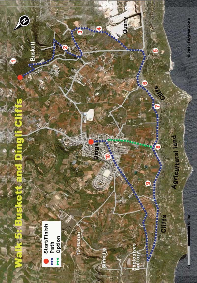
54

55 WALK 5 Clapham Junction Take the narrow country road out of Buskett and at the crossroads turn left uphill and then left again. Take the road uphill for about 300 m until you reach a sign on the right saying Ghar il-kbir and Cart ruts. Behind, you have a wonderful view of Verdala Palace dominating the exuberant woodland of Buskett. Enter through the metal gate on the right hand side of the road, walk uphill then turn to the right before a lone house. This type of habitat of fractured surface limestone with small pockets of soil is known as garrigue, a habitat for a wide range of plants and animals. A little along this track and to the right (3) you will see many linear depressions, some of them very deep, and running in a number of directions. Take some time to observe these cart ruts. Was this area, now known as Clapham Junction, an old highway of some sort? There is no generally accepted theory as to what caused these cart ruts (if indeed they are cart ruts), which are found in many parts of Malta. Have you a plausible explanation? Some theories date the tracks to the Bronze Age ( BC) as they are often located near to Bronze Age villages. Further along the path, about 10 m into the garrigue on the left, you will encounter some Punic tombs which are marked with a small rubble wall. Take some time to examine the chambers and admire the precise cutting and the marks of tools. The people who were buried in these tombs must have been quite short to fit in such a restricted space. A little further into the garrigue you will encounter the large depression known as Għar il-kbir (4). This cavern (the roof has collapsed in recent times) formed naturally as an underground cave and was enlarged by people to make a more spacious underground dwelling. It is composed of eight part natural/part dug caves, on two levels. The central depression (when it was still a cave) was used as a communal space, with the smaller side caves serving as private family rooms. Various small niches can be seen which were used to hold oil lamps and icons, while holes in the ceiling and sides of the cave were used for hanging herbs, vegetables and sacks of seeds. It is amazing to learn that this was inhabited until the 19th century! Take the opportunity to explore the central cave and the smaller chambers, some of which still have stone beds. 51
 and can admire the dramatic view.")
56 WALK 5 Dingli Cliffs From Ghar il-kbir go uphill through the garrigue and, coming near a quarry, go to the right which will take you to a track leading to the public road. Turn to the right up this road and you quickly come to the edge of the cliffs (5) and can admire the dramatic view. Note the sheer vertical faces, an elaborate boulder scree, the variety of habitats and small cultivated fields. The cliffs, part of a large system along the entire south and west coast of Malta, are in two tiers, separated by a clay slope and a plateau of boulder scree. To the left you may just make out a Bronze Age village perched at the edge of the cliff. About 2 km off the coast you can see Filfla, a very small island noted for its sea birds, flora and an endemic species of lizard. The island was originally much larger and housed a chapel inside a cave, built in This was destroyed in the 19th century by an earthquake which also caused the collapse of part of the island. Until 1971 the Royal Navy and Air Force used the island for target practice, further reducing its size. Nowadays Filfla is a legally protected reserve and access is strictly controlled. It is among the most important reserves in Malta for birds, and hosts three species which breed in large number: the European Storm Petrel, Cory's Shearwater and Yellow-legged Gull. Walk to the right along the road towards a chapel dedicated to St Mary Magdalene (6), dating from The nearby dwelling was the priest s house. Look closely at the vertical cliff face as it offers an opportunity to understand the 52 Ghar il-kbir
, the boulder scree where a blue clay layer slides over")
57 WALK 5 five main rock layers of the island. The cliffs at this point come in three distinct sections - the upper area on which you are standing (upper coralline limestone and greensands), the boulder scree where a blue clay layer slides over underlying rock to form a plateau, and the lower sheer cliffs of globigerina and coralline limestone. The erosion and slippage of the relatively soft and mobile clay layer undermines the top layer which collapses to form the boulder strewn plateau. At the bottom of the cliffs there are a number of sea caves which can be reached only by boat. The sheer scale of the sea cliffs (which can be 40 storeys high) are best appreciated from a boat. The cliffs provide a rare and valuable habitat for flora and fauna because of their relative inaccessibility to humans and the presence of fresh water. The impermeable clay layer creates springs which seep through the cliff face and support moisture loving plants. You can notice tufts of vegetation growing in crevices along the sheer cliffs and these contain endemic plants such as the Maltese Cliff Orache, Maltese Salt tree and the Maltese Rock Centaury, with its beautiful violet flowers. The crevices are also important habitats for birds such as shearwaters, while larger caves house bats which are abundant in this area. Interestingly, one group of boulders within the scree has been found to host an endemic species of snail which is restricted to that tiny area only. Keep on walking along the cliffs passing by the Radar Dome (7) and the Radar Station (8). You can notice a number of narrow roads leading down towards the cliffs; these are used by farmers for access to their fields. If you are tired or short of time you may take the road downhill to the right to the village of Dingli and get the return bus from there. Otherwise keep on strolling along the cliff road where there are a number of benches to enjoy the panoramic vista. It is very romantic here at sunset! You will come to the well known Bobbyland Restaurant (9) where you can relax with a coffee on the terrace. Walking further along the cliffs on your left, passing a set of villas, you can enjoy long distance views to the dramatic Ta Cenc cliffs in Gozo. Slightly ahead is the district of Bahrija, an area currently being considered for a wind energy project. As it is situated on a plateau some 250 m above sea level this area is windier than the rest of the island and often a couple of degrees colder. Rock Centaury 53 (photo by Martin Polidano)
, a number of side rooms (parts of which are rock cut), a well, a")
58 WALK 5 To Dingli Village The route turns sharply inland before a disused explosives factory. Nearby, though not on the walk, are the medieval buildings of Simblija which include a chapel (a simple square room with three arches), a number of side rooms (parts of which are rock cut), a well, a communal oven room and a donkey-driven flour mill. The adjacent area of Ta Baldu contains a farmhouse, below which there are caves which served as a bathing place during Roman times. There is also a stone table and benches and an olive crusher. Unfortunately there is no public access to these features which are privately owned. Small settlements such as these were common in this region which, though windswept, has areas of fertile soil suitable for farming. The road leads on towards Dingli village (10), passing by small fields and greenhouses in this tranquil agricultural area. Dingli, a picturesque village which is considered remote by locals, still retains a degree of quaintness and local character. A fair share of the inhabitants devote their time to agriculture and traditional activities such as a trip to the men s Band Club, hunting and trapping, and local markets. Take the road to the centre of the town, passing by the church whose tip is probably the highest point in the island and therefore, closest to heaven. There are a number of bars in the village where you can enjoy a coffee and that awaited trip to the bathroom. You can also enquire about the times at which buses pass through Dingli bound for Mdina and Valletta. 54
59 WALK SIX CIRKEWWA TO MELLIEHA BAY This exceptional walk takes you from the ferry port of Cirkewwa to the long sandy beach of Mellieha. Its varied features include high ridges with arguably the best views in Malta, dramatic cliffs, bleak garrigue, verdant wooded areas, small farms, the impressive Red Tower, a nature reserve and the wonderfully named Paradise Bay. Surprisingly for Malta, the walk does not pass a church. It also illustrates the challenge which Malta faces in developing a sustainable water supply. The walk is at times exciting and challenging, but always worthwhile. It is of moderate difficulty in the early uphill stretch, as you are on rough ground without a specific path, but thereafter it is easy. You will need to wear sensible shoes and, as the route is very exposed to wind, rain and sun, it is prudent to bring a jacket, sun-cream and a hat. You might also consider bringing your swimming togs for use in the clear waters of either Paradise Bay or Mellieha Bay. The walk takes about 3 hours, so bring water and a snack. There is a frequent bus service to Cirkewwa from Valletta and Sliema. The same buses service your return journey from Mellieha. CONTEXT Water is a very limited resource in Malta at present and is likely to become increasingly critical as climate change threatens to bring less rain and warmer summers. Malta receives only about 50 cm of rain annually, with just 10% falling in the 5 months between April and August. In urbanised areas most of the rain falls on impermeable surfaces and rushes quickly to the sea. In the countryside most of the rain falling on fissured rock and soil can percolate downwards to form an underground aquifer. Where the groundwater meets an impermeable layer, such as blue clay, it travels sideways and may appear as a surface spring or seepage through the walls of a cliff or valley. There are no permanent rivers or lakes of consequence in Malta and water for public supply is abstracted partially from underground aquifers. The high water demand for agriculture is met mainly by private boreholes in the limestone aquifer, licensed or otherwise. The abstraction rate for underground water exceeds the recharge rate from rainwater and so the water level in the limestone aquifer drops, thus decreasing the outflow from springs and valley sides. The result is that many former streams 55
60 WALK 6 are dry for several months of the year. This reduces/eliminates the habitats for rare water-loving plants such as reeds, tassel weeds and water crowfoots, and animals such as the fresh water crab, frogs and water snails. It also reduces the number of drinking water sources for animals, birds and insects. A good proportion of Malta s demand for potable water (almost 60%) is met by the use of Reverse Osmosis (RO) plants which remove salt from seawater. The process operates by pumping seawater through synthetic filters which have holes small enough to permit passage of water but not larger salt molecules. The RO process requires a very high energy input and, apart from the financial cost, generates considerable emissions of carbon dioxide at the electricity generation station. The government is addressing the problem through such approaches as improving the collection and storage systems for rainwater, lowering water demand through awareness campaigns and improving the regulation of abstraction from aquifers by farmers. It is also considering the safe re-use of treated sewage water. During the walk you will pass by an RO plant and a sewage treatment plant. You will notice the dramatically different productivity of irrigated farmland compared to dry garrigue and the very verdant habitats which are to be seen where water seeps from the sides of cliffs. You will also see where some permanent ponds of fresh water in a nature reserve have created an environment with a rich and diverse range of plant and animal species. You may care to wish the government well in its task of trying to reconcile the competing demands of water for human activities with a high level of protection for the country's endangered plant and animal life. THE WALK The route is shown on Map 6. Take the bus to the ferry port of Cirkewwa and resist the temptation to have a coffee there as it is much more pleasant to take it later at Paradise Bay, just about 20 minutes along the route. To begin, walk from the bus stop back along the main road, passing the Paradise Bay Hotel (1) and taking the first road upwards to the right towards Paradise Bay. You will see the Reverse Osmosis (RO) building (2) on the left and the network of pipes and pumps along the shore which supply it with seawater and dispose of salty water. Malta does not receive enough rainfall to support its high demand for water and employs three RO plants to make potable water from 56
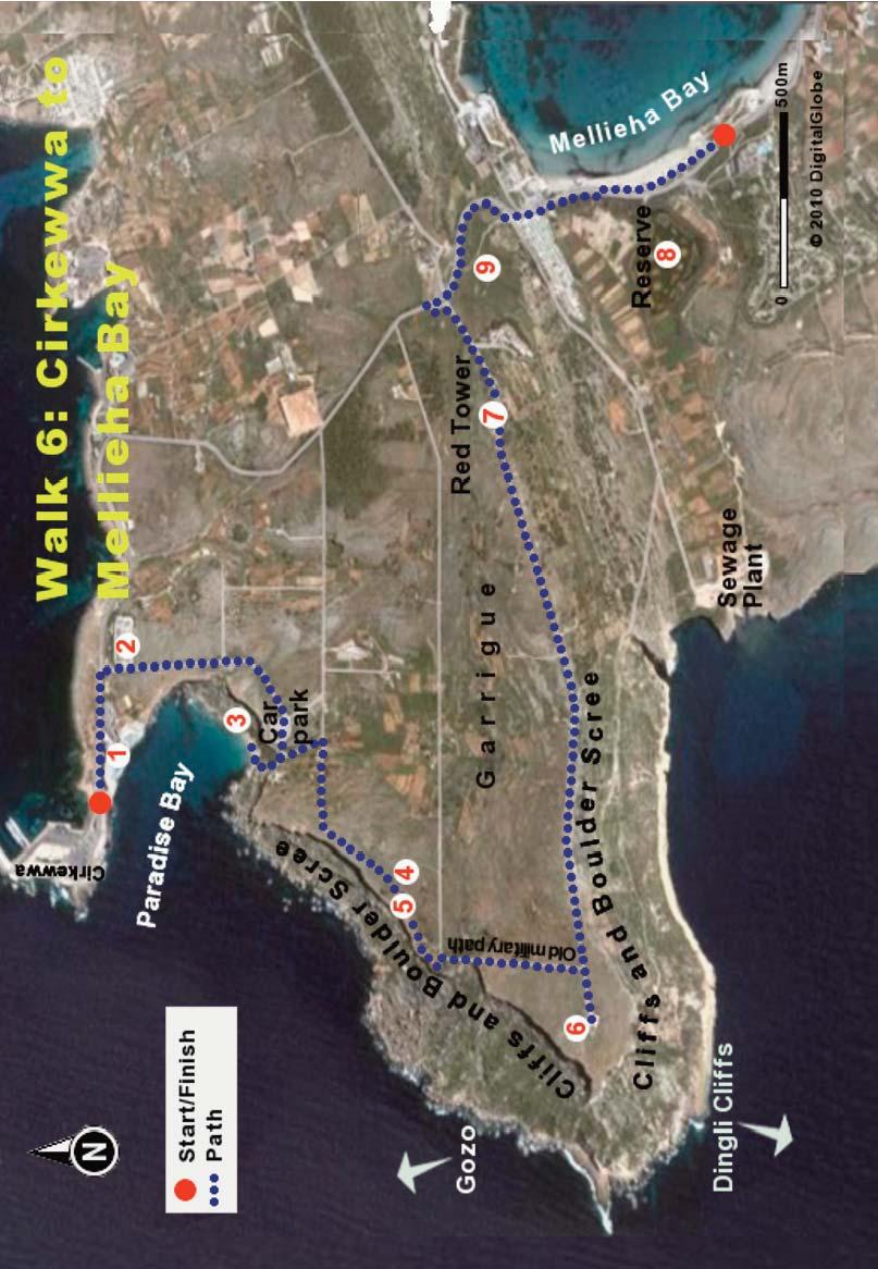
61

62 WALK 6 seawater. Note the wartime observation posts partly buried in the rocks behind the RO plant. Walk uphill along the garrigue, admiring the wild plants such as thyme with its aromatic scent, heath, lentisk and buckthorn and, depending on the season, bulbs such as garlics, daffodils and irises, and more ornate and rare flowers such as orchids. These plants attract a variety of butterflies such as the Swallowtail, Red Admiral and White Butterfly and bees such as the Bumble bee, Honey bee and Carpenter bee. The abundance and variety of such plants, particularly the aromatic thyme, give Maltese honey an especially attractive flavour. Buy some to take home! There are some prehistoric cart ruts in the garrigue area to the right hand side of the road about 50 m from the RO plant, leading to the cliff edge, but they are not easily noticed. Cart ruts are an interesting prehistoric feature, found throughout the island. They consist of linear depressions in the limestone which always come in pairs and sometimes run for long distances. The so-called Clapham Junction area near Dingli is among the best places to see them. There are a number of theories in regard to their origin but none that is fully accepted. These range from the plausible such as being the marks left when wheel-less carts continuously passed through the site, to the absurd such as the claim that they are of extraterrestrial origin. Pass through the car park and go down the steps to Paradise Bay (3). On a fine day you can easily appreciate how it got its name. The lush vegetation in the small valley through which you descend is in striking contrast to the garrigue at the upper level. The curving bay with its beach of golden sand provides a safe and pleasant bathing area which is very popular for bathing and snorkelling during summer months. The sand dunes are a rare and protected habitat in Malta and support plants such as the Sea Daffodil, and trees such as the Tamarisk, of which there are many around this bay. Consider taking a refreshment in the café here and visiting the toilet as you will not meet another until you arrive at Mellieha in about two hours. Go back up the steps from the bay and at the top turn of the first flight take a turn to the left. Take a

63 WALK 6 right turn before the next flight which leads to the car park and you will find yourself on a quiet public track. At the end of the track, to the right, walk uphill for a few metres over rough ground without a well defined path. At the top of the track you can relax to admire the view of Gozo to the right and the boulder scree below. Gazing down from this vantage point you can see the boulder-strewn flattish area where the cliff has collapsed. This happened when a layer of blue clay at the base was eroded by wave and rain action, causing the overlaying layers of limestone to collapse. Do not worry too much as this is a process of many years rather than hours. However, take care when walking near fissures in the limestone and at the cliff edge. You can notice that the fallen rocks often lie among tiny cultivated fields and you can wonder at the hard and poorly paid work involved in farming such small and inaccessible areas. These boulder screes are amongst the best preserved habitats in the islands, as they are so inaccessible and host a variety of endemic species such as Maltese spurge and sea lavenders, all adapted for harsh, wind-swept conditions. Up to the Radar Station Choose for yourself the exact route you wish the follow and wander around a little as you go to observe the different habitats and views. It may be best to take the ill-defined path close to the cliff edge until you reach a small clump of trees. Looking inland you can just notice the remnants of a rubble wall, behind which is a depression known as a doline (4) an underground cave formed through erosion of limestone by water and whose roof eventually collapsed. You can notice the stark contrast of the lush vegetation of the doline with the surrounding wind-swept garrigue. Further inland you can see where, over generations, farmers have transformed some garrigue areas into productive farmland. In some fields you can see a traditional stone hut known as a Girna, constructed from rubble stone without the use of mortar or stone slabs to support the roof. These corbelled huts provided shelter and storage area for a farmer and his tools, important in this area which is very exposed to strong winds. If you have ever visited the Atlantic coast of Ireland (with its small fields, stone huts and ocean winds) and wondered what it would be like in sunny weather, here is your answer. As you ascend you can notice an attractive stone archway (5) like some door to a long- 59

64 WALK 6 lost world, over a path which allowed access by farmers to their small fields at the lower level. A little further on you will see a set of rock-hewn steps leading to the lower fields. Keep walking upwards with the cliff to your right until you reach a small clearing at the end of a public road. Turning left and then right after about 10 m, you come to an old military path constructed by the British to improve access between individual military points and the radar station at the top of the ridge. Take the steep climb up to the ridge, admiring a small cultivated valley to the left. Arriving on the ridge, turn to the right towards the British era radar station (6). Have a wander around the area, noticing the many large fissures at the cliff edge which are impressive but dangerous to cross. You are now standing on the most western point of Malta and can enjoy a 360 degree vista that includes the wonderful Ta Cenc cliffs of Gozo and some of its towns and tall churches. In the other direction, you can see the dramatic series of cliffs that protected Malta from invasion from its southern side. Walk inland along the public road on the top of the ridge. To the right you have a view of dramatic bays, many of which are only accessible by boat. Further along the path to the right you can see the recently constructed sewage treatment plant which treats domestic effluent from the north of the island. The purified water is discharged to sea in the first bay to the right, far away from bathing beaches. Malta is exceptional in that virtually every town, house and hotel is connected to the public sewerage system and now, thanks to EU support (and laws), every system should be connected to a modern treatment plant such as you see before you. 60

65 WALK 6 The Red Tower As you walk towards Mellieha you can enjoy the view of the small but very productive farms in the valley below. The tranquil fields are separated in many cases by traditional rubble walls which add considerably to the attractiveness of the countryside. The walls act as a windbreak and form a valuable habitat for plant and wildlife such as lizards, snakes and bees. You will not see any cattle or sheep grazing the fields in Malta and almost all land is devoted to the cultivation of crops such as potatoes, globe artichokes, pumpkin, tomatoes, lettuce, wheat and, in the summer months, melons and water-melons. The size of the fields makes the use of tractors and large mechanised equipment difficult and much of the work must be done by hard manual labour or with the use of small rotavators. Farming is neither an easy or lucrative business in Malta and there is little interest among the younger generation in following in their family tradition in this regard. Consequently throughout Malta and Gozo, you can see a lot of marginal land that is no longer cultivated and is returning to a semi-wild state. The amount of land devoted to vineyards has increased in recent years and the quality of Maltese wine has improved, with some brands internationally recognised as excellent. Why not try some tonight? As you continue along the asphalt road towards Mellieha you come to the impressive St Agatha's Tower (7), more commonly known as the Red Tower. Constructed by the knights in 1649 it dominates the surrounding land. The primary duty of its garrison was to detect enemy landings in that area and to communicate the news quickly to Valletta. The tower has been lovingly restored by an NGO and is open to visitors. Go in now if it is open the 15 minute visit is very enjoyable and the view from the roof is astonishing. In the valley below you will see the lagoons of the Ghadira Nature Reserve (8), situated on low lying land behind Mellieha beach. The 6 hectare site was originally used for the production of salt from seawater in the times of the knights.

66 WALK 6 Ghadira Nature Reserve About 20 years ago BirdLife Malta converted the area into a nature reserve with lagoons, islands, observation hides and a visitor centre. This reserve is a very rare habitat in Malta and provides a valuable sanctuary for breeding species of birds such as warblers, corn buntings, coot and plover. Visiting species include grebes, ducks, herons, kingfishers, egrets, waders and birds of prey. The reserve also hosts some local flora and fauna, such as rabbits, hedgehogs, chameleon, geckos, lizards, snakes, shrimps and killifish. A number of rare plants now grow only in this reserve. The centre welcomes visitors, typically on Saturdays and Sundays from November until May from 10 a.m. to 4 p.m. Further information is available at Near the reserve there are a number of old farmhouses which are legally protected buildings in view of their authenticity and which are still in use. Continue past the Red Tower passing along an old military pill-box, until you reach the main road, then turn to the right and walk down towards Mellieha beach, passing by the wayside shrine of Our Lady of Sorrows. On your right you will be happy to see an area recently re-afforested by voluntary effort (9) which will make a pleasant difference in a landscape where trees are as scarce as a civil servant s sweat. Take the path through the afforested area to the gate at the lower end. Pass over to the promenade and consider having an ice cream at one of the pleasant cafés along the beach, the longest in Malta. At the far end of the beach you can see the hillside town of Mellieha with its conspicuous church dedicated to our Lady of Victories. You pass the nature reserve on your right. You will probably prefer to get the bus at one of the stops behind the beach rather than tiring yourself further on the steep slope up into the town. 62 Ghadira Nature Reserve
67 WALK SEVEN THE VICTORIA LINES In the late 19th century the British Army constructed a linear network of fortifications (the Victoria Lines) that run about 13 km across Malta, from sea to sea. The objective was to create an impassable barrier that would protect Valletta and the strategically important Grand Harbour from enemies invading through the many bays and inlets of the northern half of the island. This fairly challenging walk starts in the famous town of Mosta in the centre of Malta and passes along the walls of the Victoria Lines until reaching the northern coast at Madliena. The Lines, built on a high natural ridge, provide wonderful views across the countryside. Some parts of the defensive walls have been demolished by road construction or flooding, but much of interest remains. The walk takes about 4 hours and has a number of interesting options for extending it. The path brings you past military fortifications, peaceful valleys, small farms, churches inside caves, Bronze Age tombs and lookout points providing panoramic views over the countryside and the coast. This walk takes in only half the Victoria Lines (some committed walkers do the whole journey from coast to coast in one walk). The other half from Mosta to the southern coast is also very interesting but has the disadvantage that the return by bus from the relatively remote finishing point is not convenient. It is worthwhile bringing binoculars and a camera to take full advantage of the wonderful views. It is also preferable to wear long trousers as some sections of the path are overgrown with bushes which may scratch. You should also bring water and something to eat as there are no shops and cafés along the route. CONTEXT Some thousands of years ago geological activity resulted in the formation of a ridge (known as the Great Fault) which runs across Malta from sea to sea. In the late 19th century the British Army took advantage of the cliffs, hills and high points of this ridge to build an extensive system of defensive walls, forts and strong points. In honour of the Queen at that time, these were named the Victoria Lines. The aim was to protect the heavily populated central and south from an enemy invading through easy landing sites in the north of the island, such as S. Paul's Bay. 63
68 WALK 7 The use of the ridge for defensive purposes can be traced way back to prehistoric times and the knights also made use of its natural defensive qualities for military purposes. The militarization of the entire span of the Great Fault by the British Army began in 1875 with the construction of a number of strategically sited forts and batteries. The fortifications initially consisted of three large independent forts, built in the polygonal style, at Madliena, Bingemma and Mosta. A section of the defensive line south of Mosta was later fortified by means of a strong permanent entrenchment known as the Dwejra Lines. In the 1880s all the individual fortified elements were linked together with a continuous infantry wall which followed the natural configuration of the crest of the ridge, and with a moat below the wall. Where interrupted by valleys, the line of fortifications was carried on by means of strongly protected curving walls, steep steps and fortified bridges. The defensive features included batteries, magazines and, during WW II, searchlight emplacements, together with a number of barracks for the troops manning the line. Towards the end of the 19th century, new military strategies (fight them on the beaches!) and new technology had combined to undermine the likely effectiveness of the Lines. Military exercises held in 1900 suggested that it could be by-passed with relative ease and by 1907 the Victoria Lines had already lost much of their military significance and were largely abandoned. During the Second World War the lines were again brought into use and were fortified with pillboxes and anti-aircraft units. The large forts, with their heavy 9.2-inch and 6- inch guns, continued to play a dual coastal and defensive role until after the Second World War. Fort Madliena is open at times to tourists but there is no public access to the other forts. THE WALK The route is shown on Map 7. Take the bus to Mosta and get off near the church. You will be returning by bus from a point on the coast road between St Paul s Bay and St Julian s Bay/Sliema. Start the walk with a short visit to the spectacular parish church of Mosta (1), constructed between 1833 and 1860 to a design based on the Pantheon in Rome. The large stone exterior is an attractive honey colour, while the inside is a riot of colours not usually found in a Catholic Church. The honey colour arises when iron in the (normally yellow) globigerina limestone is exposed to the elements. The church is famous because of its dome and the bomb. The dome, 64
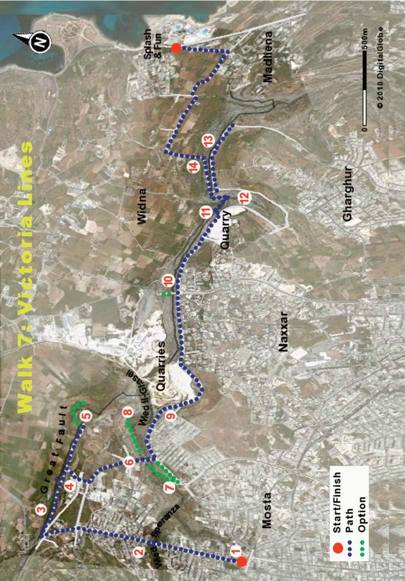
69

70 60 m high and 52 m wide, is reputedly the second largest in the world. During the Second World War a German bomb crashed through the roof during a Sunday mass and landed in the central aisle. It seems miraculous that the bomb failed to explode and that nobody was injured. One of the local theories, in addition to those based on divine intercession, is that the bomb was not fused. The bomb is still to be seen in a small room at the side of the church. Ask where it is and go to see it! Consider having a coffee and toilet stop in Mosta as you will not meet another café until the end of the walk. Set out on the walk along the straight road by the church which heads towards St Paul s Bay. After about 700 m you will pass over the impressively deep and verdant Speranza Valley (2). To the left you can see in profile the wonderful Cathedral of Mdina. To the right, on the far side of the bridge, you will notice an attractive old folks home. Such homes are becoming increasingly of interest to elderly foreigners who often find it cheaper and more pleasant to retire to Malta than remain for the winter in inclement northerly parts. After some minutes you come to a roundabout, take the road straight ahead and amble down along a curving tree-lined footpath, admiring the beautiful garden on the right. The garden contains a small wind-driven pump. Such windmills were formerly common in Malta when farmers employed them to pump up groundwater to their farms. This was sustainable in terms of wind power, if not in terms of water usage, as Malta has a serious problem with over-extraction of groundwater sources. Take the first road to the right, where there is frequently a lorry selling fruit and vegetables. The local strawberries are very nice in season. After perhaps 200 m take the steps down to the left to reach the wall of the Victoria Lines which forms the edge of a linear public park (3). Below you see beautiful open countryside with its myriad small fields and, in the distance, St Paul s Bay. The soil is very fertile here and the farms in the plain below are among the best in Malta. Many of the farms in Malta are very small, with an average farm size of less than 2 ha, so most farmers are part-time and need a separate job to earn a decent living. There is a growing trend towards organic produce which should support Malta's drive to offer a higher quality experience to tourists. 66

71 WALK 7 Walk alongside the wall towards Fort Mosta about 1 km away, admiring the many wild plants growing along the cliff, such as the spherical tree spurge and wild fig trees. You should see a variety of birds including sparrows, pigeons and swallows, and, at times, something more interesting, such as a Honey Buzzard or a Rock Thrush. Try not to notice the many spent cartridges discarded along the path by thoughtless hunters. About midway towards Fort Mosta you may notice on the left a set of wide steps leading downwards (4). These steps give access to a network of tunnels and underground chambers cut into the vertical side of the cliff. Designed to survive a nuclear attack on the Grand Harbour (or so it was rumoured), the underground facility was to serve as a strategic planning base for NATO in case of war with the Soviet Union. It is a pity that the complex has fallen into disuse and is not open to the public. As you approach Fort Mosta you can see in its grounds some of the large 19th century artillery pieces which were powerful enough to reach coastal waters. Unfortunately many similar artillery pieces, such as those in Fort Madliena, were melted down for their scrap value. Fort Mosta You come to apparently a dead end at Mosta Fort (5) and there is no access to your right. There is an interesting path to the left which leads over to a pillbox, takes you around the front of Fort Mosta and then peters out. Unfortunately this path does not always lead conveniently all the way around Fort Mosta. In many places the path is not obvious and the footing can be somewhat treacherous, particularly in wet weather. In winter the small stream in the valley will make this route impassable. Some adventurous walkers do continue along this path as it curves around below the walls of Fort Mosta so as to reach a valley at the rear and a cave containing a 17th century church. However, it is recommended that you take the option of backtracking about 500 m along the path on which you came so as to get to the valley and cave by a more foot-sure, though less interesting route. You should go over to the pillbox and as far beyond it as is convenient, before turning back. Return to the wall in the linear park you came on and head back towards the starting point. Take the first wide curving concrete path to the left (just before a 67
 and can see the famous dome to the right.")
72 water reservoir) which leads you up through the park and across a small crossroads to meet the main public road. Turn left along the public road and after some hundreds of metres you come to a roundabout at the northern edge of Mosta (6) and can see the famous dome to the right. Go straight across the roundabout and pass over the impressively high bridge which straddles the valley. The bridge is often used for abseiling practice by local climbing clubs. In the gorge there are a number of shallow caves formerly used as bee hives and these give the valley its Maltese name, Wied il-ghasel - the Valley of Honey. The steep sided valley, created by water erosion of tough coralline limestone, is the deepest gorge in Malta. The Chapel in the Cave You can now take a very interesting walk through the gorge as far as the ancient chapel in the cave. Turn to the right towards Mosta at the far side of the bridge and after about 200 m you will see a set of steps (7) leading down along the side of the gorge. Descend on the steps to the valley floor and follow the welltrodden path under the road bridge, and after about 500 m you will come to the cave on the left. Notice the small fields in this gorge and wide array of native plants, which are important for local honey production. Note the plants growing in fissures from the side walls of the valley, including some rare Sandarac Trees. Staying along the path you come to a large cave (8) with a wonderful chapel built in 1656, dedicated to St Paul the Hermit. You can appreciate the difficulty of building a chapel in that area at that time; the Maltese have always been noted for their faith and their church building. There is an interesting legend about a cranky hermit (St Corrado) who lived in the cave prior to the construction 68
 chased the hermit to St Paul s Bay.")
73 WALK 7 of the chapel and who reproached the locals excessively about their bad deeds. The locals, tiring of threats of damnation for their modest sins, (which were probably of a minor sexual nature, there not being much else to do at the time) chased the hermit to St Paul s Bay. Apparently trapped in the bay by the angry mob, the hermit spread his cloak on the water and escaped by floating on it over to Gozo. To this day there is a chapel dedicated to him in Gozo, though it is not clear why! Take some time to walk around the chapel and look inside through the door. The water from the cave s ceiling collects in a trough inside the chapel to be used as Holy Water. You can wander along the path past the cave for as long as you wish, but to continue the main walk you must return along the path under the bridges, go back up the steps and walk back towards the road bridge. Continue straight on as you pass the bridge on your left and follow the curving path along the valley edge. From here you get great views of the cave, ammunition storage tunnels associated with Fort Mosta and, further on, a very large working quarry. Look down at the quarry face to appreciate what Malta is a large limestone rock with small amounts of surface soil. The soil in the valleys, as you have seen, can be quite rich, but much of the surface of Malta is covered with shallow stony soil on top of fissured limestone. This garrigue represents an important natural habitat for a wide range of plants (such as thyme, orchids and medicinal plants) and animals. To a disinterested observed it appears to be worthless land, and as a result has suffered greatly through indiscriminate building and dumping. Take care as you proceed because the path disappears and you are forced to walk on the road. Across the road to your right you will pass two Bronze Age dolmens (9) behind a low stone wall. This area of Mosta is well known for Bronze Age remains such as cart ruts, tombs and megaliths. Follow the road around and downhill, until you again meet the walls of the Victoria Lines. On the right the houses start to becom increasingly prosperous-looking. 69
.")
74 WALK 7 The Ear Coming to a major roundabout (with roads signposted to St Paul s Bay and Naxxar) you can see, about 100 m downhill to the left, a restored Second World War pillbox. Go straight across the roundabout to walk along the ridge road, where you will notice again the walls of the Victoria Lines (10). As you look towards the sea you can see in the foreground a number of modern telecommunication dishes and beside them an unusual, large, curved wall, appropriately called il-widna (the Ear). This was an early Second World War acoustic listening system which allowed young ladies with sensitive ears to hear bombers coming from Sicily, long before they could be seen. It was said that with the wind in the right direction they could detect the planes revving their engines before takeoff from the airfield in Sicily. Look past that installation to the coast where you can see a 17th century knight s tower. It also was built for military communication purposes, with smoke or the sound of cannon being used to send warning signals from one tower to another until the message reached the headquarters of the knights in Valletta. You have time now to check your mobile phone for important messages and to consider how communication technology has improved so wonderfully. Wied Anglu Continue walking along the now narrowing and deteriorating road, noticing another large quarry on the right and a narrow strip of garrigue on the left (11). The wall of the Victoria Lines is at the far side of the garrigue, but is not easily seen from the road. At a point of your own choice somewhere opposite the entrance to the quarry you must pass (with a little difficulty!) through the garrigue 70
75 WALK 7 to reach the narrow path beside the wall. Walk to the right along the path, enjoying the view of the small farms with beehives and the fields of vines and cereals. The wall becomes more substantial now as it turns to the right into a small isolated valley (12) Wied Anglu (Angel s Valley). Exciting isn t it? The path is somewhat overgrown and at some points you must take care in squeezing between the wall and the bushes. The path descends to a bridge across the valley floor and as some of the steps are in poor condition you should take special care. Once you are on the bridge across the valley floor, the sense of isolation and tranquillity is something special, particularly in Malta. The path improves a little as you go upwards on the far side. Stay close to the wall as you go over the top of the ridge and then, just as you are perhaps beginning to be concerned, you find yourself at a small car park, formerly the site of a battery. What a pleasant surprise! Go straight across the car park to stay on the ridge path (ignore for the time being the downhill path). The path and wall have recently been renovated and it is a pleasant change from the preceding rough patch. Go on for about 500 m until you come to a lookout point on top of a pillbox (13). What a wonderful view along the coast to Gozo, with Comino in front! The large hill you see beside the coast is the island s old landfill which is currently being rehabilitated as a nature conservation area and public amenity. The path you are on continues towards the sea for about another 500 m and then turns inland towards the village of Gharghur. There is another wonderful viewing point as the path turns inland. It is a long though pleasant walk to continue on this route towards Ghargur, the coastal road and the sea. However, it is preferable (and shorter by about 2 km) to turn around, go back to the small car park and take the lower path towards the valley floor. As you go downwards along the path you pass an area known as Gebel San Pietru (St Peter s Rocks) (14) which has caves with various features of interest in particular an early Christian shrine. The area has everything an early settler could have wanted water in the valley, proximity to the coas and good agricultural land. A cave here with its spectacular views would certainly have been highly desirable in those early days. At the valley floor you join a network of country paths which lead you past delightful small fields and farms and, of course, an old church. Arriving at the coast road you turn to the left, go past the Splash and Fun Water-Park and you are happy to see a café (and toilet) and a bus stop. Almost all buses going south (with the sea to your left) will take you to Sliema, with onward connections to Valletta. Buses going north can take you to Bugibba. 71
76 WALK EIGHT AROUND SLIEMA This is a very pleasant and easy walk, mainly along a seaside promenade. It features outstanding sea views, examples of good and bad architecture, historical monuments, pretty bays, fine boats and a profile of Maltese people socialising in parks and cafés. The overall length of the walk from Msida to St George s Bay is around 10 km and could be done, without lingering, in a little over 3 hours. However, good walks, like good food, should be taken slowly, and a leisurely approach is recommended. There are plenty of places to relax over a cup of coffee as you are rarely more than 200 m from a café. CONTEXT Sliema is where the middle class live and where many tourists stay. It is an attractive, interesting area with a wide range of facilities. It is located on and around what used to be a stony hill, on a peninsula across the bay from Valletta. Sliema has much to be proud of in terms of architecture and much to be ashamed of in that regard also. The ready availability of easily worked, attractively coloured stone has given Sliema and Malta a stock of elegant and good looking churches, forts, towers, public buildings and homes. The stone buildings of Sliema, constructed in the early 20th century, have a style and quality that epitomises the confidence of the British Empire at its height. The rich architectural inheritance of Sliema has suffered in recent years, particularly along the seafront, through the demolition of old Victorian and Edwardian villas and their replacement by characterless apartment blocks and hotels. Examples of grand seafront villas, such as Villa Drago in Tower Road, can still be seen, although these are practically engulfed by modern apartments. The tranquil side streets contain many quality buildings with delightful stone and wooden balconies typical of Maltese period houses. A major advantage of a projecting balcony was that it allowed the curious and the busybody to monitor their neighbours comings and goings. Nobody does that much anymore it has been superseded by reality programmes on television. The citizens of Malta, as you can see on this walk, are a sociable and pleasant lot but without superficial friendliness. They are happy to give directions, advice and opinions. They do not take themselves too seriously and can laugh at their own foibles look at the photos shown on the website The double bed being carried home on the roof of a mini is particularly humorous. 72
77 WALK 8 While teenagers may be boisterous, vandalism or violence is rare. There is little crime in Malta, which is perhaps attributable to its strong Catholic and family traditions. Malta is among the safest countries in the world for tourists, a feature which must be very attractive to those who have visited certain countries in South America or Eastern Europe. Instead of crime the Maltese have cars. Although it has an excellent bus service Malta still has a car ownership rate that approaches that of the US (75 vehicles per 100 people). This will be evident to you in the bad traffic jams you will observe, particularly along the coast road on this walk. You may also notice a high proportion of old or classic cars (depending on whether you are buying or selling). The Maltese take pride in repairing and renovating old cars and as the small size of the island keeps the annual mileage to a low level, the cars last for a very long time. The taxis typically are over 20 years old but are well maintained and fully functional. Sliema contains many small shops which have not yet lost the usually fatal battle against the large supermarkets. Ironmongers, watch repairers, pet shops, sellers of religious goods, small grocers and gilt restorers still manage to make a living but, in many cases, not a great one. Though Lidl has recently opened some supermarkets, there are as yet no hypermarkets of the size and style favoured by Tesco and Carrefour. The difficulty and cost of putting together a large parcel of land in a suitable area seems to prevent their advance. There are some supermarkets in Sliema but you will hardly notice them as they are usually in the basement of modern apartment blocks. Sliema does not have enough space for a park. What it has instead is a first class promenade that extends for several kilometres to Valletta in one direction and to the very pretty St George s Bay in the other. This promenade, a wonderful asset for locals and tourists, provides the route for the walk around Sliema. THE WALK The route is shown on Map 8. Any bus going through Sliema to Valletta will take you to the starting point of this walk. Get off at the bus stop before the bridge over Msida Creek, close to the beautiful twin-spired Church of St Joseph the Worker. The walk starts along the footpath (1) at the side of Msida Creek, heading 73
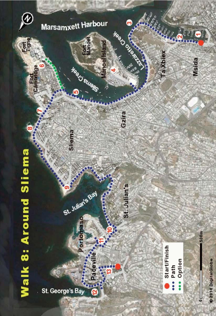
78

79 WALK 8 towards the sea. The creek provides safe anchorage for a variety of boats, some of which are quite modest. This is not the estuary of a river; Malta has no permanent rivers due to the absence of summer rains. The creek is a flooded river valley, formed many thousands of years ago by rainwater which gradually dissolved the soft limestone rock on its journey to the sea. With the rise in sea levels after the last ice age the river valley was flooded and became an inlet of the sea. This erosion process has carved many valleys and interesting geological features throughout Malta and Gozo. Across the water of the creek you can see an attractive linear park and rows of apartment blocks and hotels, many in need of sensitive redevelopment or destruction. To your left you have some small shops and pleasant cafés such as the Busy Bee, well regarded for its excellent sweet ricotta cannoli. Ahead you can see Valletta and the impressive dome of the Carmelite church. Continue walking past the Mamma Mia restaurant (2) to enter the car park of the Msida Marina. You cannot help contrasting the new overbuilt apartment blocks on the left with the next row of elegant period houses. The Whitehall Mansions, which house the UK and EC embassies, are particularly attractive. As you walk through the tree-lined car park you are happy to note that much of the original style and quality of the area is still retained. Going forward, the view to your right begins to open up and you start to see the extensive and robust defensive walls of Valletta, probably the best in the world. You come to a beached yacht The Black Pearl which operates as a restaurant. Passing the Guze restaurant and the Water Polo grounds you get a view of the open sea (3), with Manoel Island to the left. As you walk you can continue to admire the quality of the seafront houses and these give you an impression of how many parts of Sliema would have looked before the start of mass tourism developments in the 1970s. Note to your right that the bollards for tying up boats are made of real cannons embedded in cement. This might seem wasteful, but what use would you make of redundant cannons? Keep to the path between the park and the sea and pass along by the marina with its mixture of boats and yachts which, as in all countries, are little used but highly priced. Quite often you will see the world class super-yachts of billionaires and marvel at their elegant 75

80 WALK 8 beauty and limited utility. The marina, between the peninsula of Valletta and Manoel Island, offers vital protection against winter storms. While the Mediterranean in summer is quite tranquil, its winter storms are frequent and surprisingly fierce. It was one such storm that caused the ship carrying St Paul to Rome to be shipwrecked on Malta and led to Malta becoming the first Christian country. Be sure to look in the clear water of the bay- often large schools of small fish are to be seen. Manoel Island Walking between the park and the coast you pass in front of a petrol station to come to a small bridge leading onto Manoel Island (4). An amusing feature to be noted (as you digress a little onto the island) is Duck Village. This unique low cost facility consists of a complex of small brick houses which provide basic but seemingly adequate accommodation for many duck families. The ducks seem untroubled by the presence of cats and vice versa. It will make you smile. Manoel Island, originally known as 'Isola del Vescovo ("the Bishop's Island") contained a quarantine hospital (Lazzaretto), constructed in 1643 to house an influx of plague and cholera victims from vessels. It was unfortunately destroyed by bombing in WW II. The island also contains a substantial star-shaped fort with its walls and ditches constructed from the limestone rock of the island itself. It was built between 1723 and 1755 under the patronage of Portuguese Grand Master Manoel de Vilhena. It suffered severely from bombing during the Second World War when Manoel Island served as a British submarine base. This naval base made a substantial contribution to the defeat of Rommel s forces in Africa as in some months submarines destroyed up to 50% of the ships ferrying vital supplies from Italy to the German forces. The fort is currently under reconstruction and will soon house an upmarket development of apartments, shops and cafés. The clear waters around the island are an interesting diving attraction, in particular because of Vessel X131, a Lighter constructed for the Gallipoli campaign in 1915 and sunk one night in 1942 by a torpedo. It rests underwater among the rubble from the bombed fort

81 WALK 8 and the Lazzaretto hospital. Return over the bridge and turn to the right along the promenade, heading to what is known as Sliema Strand (5). Note the increasing bustle as you amble along the pleasant tree-lined promenade. Maybe it is time for an ice cream or coffee? Notice that the left side of Manoel Island still contains an untouched natural habitat of mixed trees and shrubs. Military bases throughout the world have (unintentionally) played a vital role in protecting endangered habitats by restricting public access. Opposite the commercial heart of Sliema (i.e. the Marks and Spencer shop) you will see the embarkation point for the ferry to Valletta and will receive many offers of boat trips around the harbour. A boat trip from Sliema Strand is a must-do activity. You can take a two hour trip of all the harbour, which is great, or a whole day trip around the Maltese islands, which can become boring and, in bad weather, sickening. Generally an hour or two on a boat is more than enough for most people. A good option is to take the local ferry from Sliema to Valletta which is cheap, takes only 10 minutes and provides spectacular views. The view across the water to Valletta from Sliema Strand is as good as you will get anywhere in the world, particularly at night. Valletta, a world heritage city, still has the appearance of a medieval city and there are few modern intrusions in the vista. The Anglican Cathedral in Valletta can be seen cheek by jowl with the impressive dome of the Catholic Church of Mount Carmel. The Maltese are a very tolerant people and there is no antipathy on the part of Maltese Catholics towards the Protestant faith of their former UK governors. At the tip of Valletta you can see the mighty defensive walls of Fort St Elmo. Few of the many tourists admiring this view of the fort are aware of the critical role it played in the defence of Western Europe against an expansionist Ottoman Empire! This first siege of Malta in 1565 proved to be one of the most bloody and crucial sieges in history, comparable to that of Stalingrad in the Second World War. The Sliema bus terminus is just a little further past the ferry embarkation point. This is not a specific building but a series of bus stops by the promenade. Tigne Point (6) is the name of the narrow peninsula at the seaward end of Sliema, one of several points from which the Turks showered cannon balls onto Fort St Elmo. In the Second World War three forts were strategically located here to defend Valletta from a seaborne 77
82 WALK 8 invasion. These forts, Fort Cambridge, Fort Tigne and the interconnecting Garden Battery, have recently been restored as part of the major residential and commercial development you see ahead of you. You have the option of going forward to enjoy wonderful views of Valletta from a new raised walkway at the edge of this development or of taking the shorter route across the peninsula by going up Tower Road. This busy shopping street begins to the left about 20 m beyond the M& S store. The road contains many shops and, on the right behind green railings, the magnificent but dilapidated Villa Drago and its garden. Walk onwards to meet the promenade again near the Tanti Palmer kiosk (7). There are some small sea-hewn caves along the coastline here. One of these, known as Ghar id-dud (literally Bug s Cave), gave its name to a once very popular entertainment plaza built on a pier into the sea. Unfortunately the plaza has been destroyed by the rough storms which batter this part of the island in winter. Towards St Julian s On the promenade opposite the Preluna Hotel you pass a very attractive low fort, formerly Sliema Point Battery and known amongst the Maltese as Il- Fortizza (8). In spite of its ancient appearance it was built in 1876 and served as a searchlight position in WW II. The interior of the fort has been renovated to turn it into a restaurant, and the work included the roofing-over of the parade ground to form a large room in the centre. The landward side of the promenade consists in the main of uninteresting tourist hotels, restaurants and apartment blocks, though a few period houses still survive to mock the tasteless newcomers next door. There are few beaches in this part of Malta; the coast here is mainly composed of cliffs and flat areas of yellow limestone. The limestone rock has been modified over the years by the needs for defence from invaders (Turks/French/Italians/Germans) and to allow easy access to the sea for swimmers. You can continue walking along the promenade but it is more interesting to go down the steps onto the natural limestone at sea level. The steps just beyond the Fortizza are a suitable entry point. It is surprisingly tranquil to walk at this lower level where the traffic noise can hardly be heard. This area is very popular in summer with tourists and locals. It can be very pleasant to relax on a towel on the flat limestone, though a beach bed is more comfortable. As there is no tide of any consequence you can lie close to the cooling sea. The limestone does not get too hot, perhaps due to its light colouring, but it does retain comfortable warmth in the early evenings. Confident swimmers jump off the 78

83 WALK 8 edge of the rocky platform straight into deep water. For others, there are ladders and small pools cut into the rocks, fed by the lapping waves and the small tide. There are usually people snorkelling in the clear and warm sea. The fish are not as brightly coloured as those in tropical waters but they are plentiful. However, jellyfish can be a problem at times, depending on season and wind direction. Notice the fossils of ancient shellfish in the rock as you pass by the Surfside restaurant. You can also notice a number of rock hewn square pools near the water s edge. Maltese entrepreneurs had the brilliant idea of carving out these pools, providing covers for protection against the sun and renting them to families for private use, on a daily basis. Come up onto the promenade again after you pass around by St Julian s Tower (9). Many such towers were built along the coast of Malta to provide early warning of a Turkish invasion. Each stone tower is within viewing distance of the next, so that a signal, such as by smoke, can pass from the tip of Malta to Valletta in a couple of minutes; such an early warning system would have been be invaluable in preventing a surprise attack. However, apart from a few skirmishes, nobody really attacked! Back on the promenade you find yourself overlooking Independence Gardens - a pleasant park loved by children, which celebrates the freedom obtained from Britain in Independence was achieved on the basis of the British asking Malta through a vote whether it wanted independence. Not exactly the classic struggle of a colony to free itself from an evil Empire! Malta is a member of the Commonwealth and continues to have many connections with Britain. In particular the Maltese are enthusiastic supporters of British football clubs, such as Manchester United and Liverpool. Independence Gardens are a haven for stray cats and in the evenings you often see people, usually middle-aged ladies, feeding the cats. The local council has provided designated cat feeding points in the park and have banned the feeding at any other point. However it is difficult to see the local council taking well-meaning ladies to court for putting out cat food at unapproved locations! Across the water of St Julian s Bay you can see the Dragonara Casino in the distance. It looks like a fake Las Vegas casino but is in fact the former palace of an Italian noblewoman. The promenade walk brings you past gardens, fountains, sculptures and lots of cafés. There are few international chains of restaurants in Malta and many 79

84 WALK 8 shops, restaurants and cafés retain their own individualistic style. The food in the main is aimed at tourists and is of reasonable quality and price, favouring pizzas and pastas. There are notable exceptions- for example, the award winning Kitchen Restaurant across the road from St Julian s Tower is superb. Continuing along the promenade you come to a group of palm trees and an impressive stone-globe water feature. Do you understand how such a heavy object can be rotated with such little effort? As you walk along the sea shore you reach an exquisite building, the Barracuda restaurant, at the water s edge, and further on, to the left, take note of the very impressive Balluta Buildings. This classy apartment block, built in 1928, would not be out of place in Whitehall or Regent St As you amble along you will notice signs for diving schools offering a range of services to visitors. Malta is a well regarded diving destination because of the clarity of the water, the abundance of marine life and the variety of underwater features such as caves, reefs and sunken ships. The water polo grounds provide a relaxing evening s entertainment for coffee drinkers in the overlooking bars. Continue walking along the promenade as it curves around the small bays, noticing the eclectic mix of buildings. You cannot miss the Love Statue (10), a well known meeting point at the innermost point of the bay. The pretty bay, surrounded by period houses, still contains some traditional colourful fishing boats. The majority of the old boathouses have been converted into fashionable shoreside restaurants. It is a very attractive area, particularly at night, with the extensive coloured lighting creating a romantic Mediterranean ambience. Towards Paceville Walk about 300 m up the hill from the Love statue until you reach a small modern park on your right. Go across the garden (11) and through the central arch of the fashionable Portomaso complex and its striking blue tower. It is worth descending the long set of steps to see the marina and its range of luxury boats. Though attractive and functional, the marina appears to lack character and is in need of features such as old fishermen with leathery faces mending nets. Go back up the steps and take the road downhill to the right (but not the one 80
.")
85 WALK 8 immediately to the right which leads to the beautiful Hilton Hotel) and enter the lively area of Paceville. Passing by a modern church, restaurants and the entrance to the Casino and the Westin Hotel, you reach the small but pretty St George s Bay (12). This sandy bay is a summer favourite of the students who attend language schools in the Sliema/Paceville area. Many Russian, Spanish and Eastern European students come to Malta each year to learn English and to improve their social and drinking skills. They are an attractive and goodnatured lot who fill up buses and cheap cafés and add greatly to the liveliness of the area. They also contribute substantially to the economy of Malta. Paceville (13) contains very many restaurants, bars, tattoo shops and hotels and constitutes the major nightlife centre of Malta certainly for teenagers and young adults. The entertainment options range from the basic but fun Scotsman s Bar with its Elvis impersonator to the elegant Hilton and Westin hotels. The Eden Cinema complex with 15 screens is likely to be much more attractive to people who have been out walking during the day than the numerous discos. Paceville hosts a number of inappropriately named Gentlemen s Clubs where Eastern European ladies dance as provocatively as they can on table tops, in bikinis. Topless dancing (or bathing) is not permitted in Malta. There is a high degree of open-air drinking which is boisterous but not aggressive. Walk up to the centre of Paceville to get the return bus to any part of Sliema. The majority of the buses will also take you on to Valletta. St George s Bay 81

86 WALK NINE THE ISLAND OF COMINO This wonderful walk starts and ends at the Blue Lagoon in Comino, the small island midway between Malta and Gozo. Comino, with an area of 1.5 square kilometres and only eight residents, is largely unspoiled. Traffic is non-existent, while noise is the exception rather than the rule. Comino is very much what Malta would have looked like during the time of the knights, so you can feel that this is a trip back in time. Comino is a designated protected area because of its plants, animals, scenery and geology. It hosts historic defensive features because of its strategic location between Malta and Gozo. The very pleasant features of this walk include a boat trip to the island, impressive sea caves and other geological features, forts and look-out points, a wide range of native plants and birds, stunning views and an opportunity to swim at the beautiful Blue Lagoon. The length of the walk is about 8 km and you should allow yourself at least 4 hours on the island to enjoy it all at a leisurely pace. Taking the boat journey into account this is a full day s trip, but well worth it. There is little protection from sun, wind or rain on the island so it is best to do the walk in spring or autumn and to take a day s ration of food, water and sun-protection. It is worth bringing binoculars if you have an interest in birds and a towel and swimming costume if you plan to swim in the sandy and safe lagoon. You get to the island most conveniently by taking a ferry to the island from the small harbour opposite the Riviera Hotel near Cirkewwa. You may also take a small ferry to the island from Mgarr Harbour, if you are staying in Gozo. CONTEXT Comino, named after the cumin herb which was once cultivated there, was inhabited by farmers in Roman times but was later abandoned. Whether this was voluntarily or whether its inhabitants were carried off into slavery by pirates (as happened in Gozo) is not known. In the Middle Ages, Comino became a busy pirate s den because of the protected bays and deep sea caves along its rugged coastline. 82
87 WALK 9 The Knights of Malta made use of the island as a hunting ground for wild boar and hares and for falconry. The impressive Santa Maria Tower was erected there in 1618 by Grandmaster Wignacourt to protect sea traffic moving between Gozo and Malta. Knights who were convicted of minor crimes were occasionally sentenced to the lonely task of manning the tower. Other interesting structures in Comino include a tiny chapel dedicated to the Sacred Family Upon its Return from Egypt, located above Santa Maria Bay. This was built in 1618 on the site of a chapel from the 12th century. The small coastal fort, Santa Maria Battery, was built in 1716 to protect the South Comino Channel. The knights also constructed an army barracks oin Comino and this was later adapted to serve as a 20th century isolation hospital. Modern structures include the Comino hotel, an abandoned pig farm (built as an isolation farm during an outbreak of foot and mouth disease) and some British army buildings from around the time of the Second World War. Today Comino is a protected area for birds, animals and plants. Bird species include hoopoes, quail, herons, birds of prey and thrushes, including the Blue Rock Thrush. The fauna of the island includes shrews, ferrets, wild rabbits, snakes and lizards, but you are unlikely to see any of these (except the lizards) when you are there in the middle of the day. What will be more obvious are the wild flowers and shrubs. Comino is dominated by garrigue, a habitat of shallow soil on fissured limestone which supports a wide range of plants. The plants you will see during the walk will depend on the season of your visit. During the dry months, there will be a predominance of wild thyme and aromatic shrubs which you cannot miss because of their wonderful smell. In other months you can find beautiful bulbs in flower such as asphodel, squills, perfumed narcissi and orchids. Though small, the orchids have a range of impressive shapes which for purposes of pollination imitate bumble bees, spiders and so on. The sea around Comino is a marine protected area and is well regarded for its dive sites, reefs, impressive caves and a recently scuttled army patrol boat. THE WALK The walk is shown on Map 9. Bring water and snacks with you as they may not always be conveniently available on the island. The United Comino Ferries company ( offers a half-hourly service in summer from the Marfa jetty opposite the Riviera Hotel. It operates year-round, but the weather between the end of November and beginning of April is often so bad 83

88

89 WALK 9 that they can t run a scheduled service, so check beforehand about the timetable for the day of your trip. Ask the bus driver to let you off near the Riviera Hotel which is 2 bus stops before the terminus at the Cirkewwa ferry port. Tickets can be purchased at the boat. Check the return times from Comino with the captain of the ferry. The boat trip is very pleasant and provides wonderful views of caves and cliffs from sea level. The walk is circular and anticlockwise around most of the coast of Comino. The walk commences at the Blue Lagoon (1) which, on sunny days, lives up to its name. The reflection of light from the sandy sea floor gives the appearance of a tropical sea, just like in ads for Bounty bars. The lagoon is often extremely busy with tourists and boats during the summer months, but is more relaxed and pleasant during the off-peak season. There is usually a kiosk in operation near the lagoon pier selling water, ice cream and snacks. However it is better not to rely on this for your water as opening may depend on weather, season and the likelihood of customers. Starting to the right of the lagoon (as you face inland) take an uphill path along the rocky ground and walk towards the tower. Along the way (2), take time to look at the caves including two which have collapsed and now form arches. Admire the diversity of plants along the path, particularly the thyme which is wonderfully aromatic. Continue along the path toward the tower passing near the cluster of old British defence buildings and an isolation hospital with orchard, stables and an aviary with a number of exotic birds. Santa Marija Tower (3), part of a chain of defensive towers constructed at vantage points along the coastline, allowed rapid communications (by smoke or cannon fire) between the islands of Malta and Gozo in case of attack. Its construction was partly funded by the sale of Comino brushwood, as wood was then, as now, an expensive item on Malta. The tower served as a place of imprisonment in the 16th and 17th centuries for errant knights, and during the period of French control ( ) it served as an internment camp for 85


90 WALK 9 suspected spies. The tower saw active service again during both world wars. Since 1982, it has been the property of the Armed Forces of Malta. It has been renovated and now serves as a look-out to guard against smuggling and the illegal hunting of migratory birds at sea. Inland from the tower is an excellent spot to spot birds. The 2002 film, The Count of Monte Cristo, used Santa Marija Tower to represent a prison. The tower is normally open to tourists during the summer season. Enjoy the impressive views from the tower towards Malta, the open sea, Cominotto and the Blue Lagoon. Walk down towards a small orchard and water reservoir from the British period. The Comino Channel is, in geological terms, a drowned valley and the Maltese archipelago was once a single landmass of limestone. It is a pleasure to take a stroll down to the little beach just beyond the tower. Take the path inland towards the abandoned pig farm (4) and go forward to the Santa Maria Battery, erected in 1716 at the same time as two other batteries facing the South Comino Channel from Malta. You can still see the original 24- pounder cannons which formerly were complemented with four 6-pounder cannons. This coastal battery was built to resist the possible disembarkation of enemy ships and contains a blockhouse for storage of ammunition. From the battery you have a good view of the northern coast of Malta. Below the battery to the right there is a small cave and a wonderful area of garrigue with sphereshaped yellow-green euphorbia plants. Taking the path back across the pig farm you may either turn east towards the helipad (which is rarely used) or, preferably, go down towards the central valley. Notice the character of the land changing from natural, rugged stony soil to improved agricultural fields, used for growing crops such as tomatoes, 86 Near the Battery
.")
91 WALK 9 potatoes, olive trees and stone fruits. After a few hundred metres you will reach an abandoned farmer s cottage and a bench (5) an ideal spot to have a short rest and lunch. By now you are about mid-way through your walk and enjoying the tranquillity. After the break continue walking downhill along the road towards the sandy beach of Santa Maria (6). You will notice a number of orchards and farmed fields with good quality red soil - although they tend to dry out unless irrigated. The beach was formerly part of a small marshland, but the extraction of water for agriculture, tourism and camping has nearly eliminated that natural aspect. You can admire impressive tamarisk trees growing in the sand close to the beach. On the right hand side of the beach there is also a police station, originally built as a look-out post in 1743 but now only manned infrequently. Walk towards the marvellously named Chapel of the Sacred Family Upon its Return from Egypt (7). Of somewhat unusual shape,it has a buttress wall at the back to prevent ransack by Muslim pirates (not always successful as the chapel fell prey several times). In summer the chapel offers relief from the sweltering heat outside, while in colder weather it provides an aura of silence and peace. It is still open for weekly mass; the celebration of its feast day, including the fireworks display have, not surprisingly, Chapel of the Sacred Family ceased. You may care to divert inland a little to visit the hilltop cemetery (8) with its lone cypress tree, which served the isolation hospital. Walk around the beach and cliff facing Gozo and past the hotel. Along the shoreline you can note a number of signs (9) relating to electricity cables running from the power station in Malta to Gozo, through Comino. You can also see the pipes which supply potable water of excellent quality to Gozo. Return to the Blue Lagoon by any of a number of pleasant paths and have an ice-cream while you wait for your return ferry. Take a swim if you have brought your trunks, otherwise don t, as nude and topless bathing are prohibited in Malta. You can swim across to the little island of Cominotto about 100 m across the lagoon, although you should be careful of motorised pleasure craft. On the return journey to Malta the boat captain will often divert from the direct route to show you some of the more impressive caves, islets and arches. 87
92 WALK TEN THE SALTPANS OF GOZO This triangular walk starts and ends at Victoria (aka Rabat), the capital of the beautiful island of Gozo. The walk passes through tranquil and scenic countryside to reach an extensive system of saltpans along the wild northern coast, relics from a time when salt was obtained from seawater using a process of evaporation from shallow basins in the coastal rocks. The cliffs in this area are relatively soft, allowing the wind and rain to create fascinating and beautiful shapes such as deep ravines, steep hills and flat yellowish expanses. The surrealistic views are astounding in this wild and wonderful place; there is nothing quite like this elsewhere in Europe. Other noteworthy features of this walk include beautiful valleys with their many wild flowers, rubble walls, attractive farmhouses, small well-tended fields, ancient churches and the seemingly impregnable Citadel. The overall walk is about 12 km which, without dawdling or coffee break, should take about 4 hours. We suggest you make a full day of it by first visiting the impressive Citadel of Victoria (the walk begins near its entrance). Cafés and toilets are to be found at a number of locations along the walk. You have the option of shortening the walk by ending at the coastal town of Marsalforn and taking the bus back to Victoria or perhaps taking a taxi directly to the ferry port. The ferry to Mgarr in Gozo departs very frequently from Cirkewwa while a bus awaiting the ferry s arrival will take you to Victoria in less than 20 minutes. The ferry trip in itself is very enjoyable as you obtain wonderful views of the island of Comino, its sea caves and high cliffs and glimpses of the Blue Lagoon. Come on an early ferry and allow yourself plenty of time to relax in Gozo. Consider having dinner in Mgarr or Marsalforn before taking the ferry back to Malta after a pleasant and rewarding day. CONTEXT Gozo is a small island off a small island. It is essentially a limestone rock with limited areas of good soil in its valleys. It has no significant harbours, no permanent rivers, no mineral (except building stone) or forest resources. Not a great basis for providing a good living for its inhabitants! What it does have is sun, sea, ancient buildings, beautiful flowers, sandy beaches, wonderful landscapes, hardworking people and a place in history as it is believed to be the mythical island where Calypso seduced Ulysses in Homer s Odyssey. 88

93 WALK 10 Gozo was populated from an early age as shown by the dramatic Ggantija temple complex near Xaghra - one of the oldest free standing structures in the world (about 2500 BC). Go see it, as it is wonderful! The population of Gozo fluctuated considerably throughout the centuries with increases in good times and population losses during famine years. Attacks by slave traders were a major problem in the middle ages. Raiders could arrive unexpectedly over the horizon to round up locals who were then carried off into slavery. In 1551, in the worst of those attacks, Ottoman forces carried off almost the whole population (about 5,000) of the island into slavery in Libya. The island was re-populated between 1565 and 1580 by people from Malta, with the aid of the knights. You can readily understand why until 1637 all Gozitans were required by law to spend the night within the Citadel of the Victoria. The island developed peacefully since those uneasy times and it now has a population of around 35,000 who make their living (but not easily) through tourism, building, farming and fishing. The Gozitans have their own distinct dialect (which Maltese people sometimes find difficult to understand and which varies somewhat for every town) and their own customs, including their own mini-carnival. The island is still quite rural and the small fields and lack of mechanisation present a tranquil rural landscape almost gone from other European countries. With the ready availability of limestone of varying strength and colour, the Gozitans have developed renowned skills as stone-masons. This is evident not just in the many fine churches on the island but also in the ordinary houses of village and countryside. The Gozitans are not a rich people but their substantial and ornate stone houses might make you think otherwise. For such a small island, Gozo has a large number of churches - 22 in all. The church in Xewkija has a capacity of 3,000 and a dome larger than that of St Paul s Cathedral in London. The recently built Ta Pinu Basilica is as beautiful as any of the more ancient churches. Saltpans Gozo is known locally as the Island of Three Hills 89
94 WALK 10 since it is composed of a number of steep hills and fertile valleys abundant in clay. You can notice that nearly all the towns are built on the apex of flat-topped cliffs or mesas, clearly for improved defence and to conserve the valuable farmland. The Citadel itself is built on the central mesa of the island. The interesting geology includes a number of dolines (the most famous are found at Dwejra), deep ravines, sea cliffs (such as those of Ta Cenc), an inland sea and a wonderful rock formation known as the Azure Window. The natural habitats of Gozo are somewhat distinct from those of Malta since over 60 percent of Gozo s coast is composed of cliffs, which are largely inaccessible or undevelopable. The cliffs host bird species such as shearwaters, storm petrels, barn owls and thrushes. The island has retained habitats which have become rare in Malta such as the sand dunes at Ramla Bay (well worth a visit) and some permanent freshwater pools. Some endemic species such as the Maltese everlasting (endemic to Gozo), Maltese hyoseris and Malta fungus are found only in a few places. Some plants such as the sea holly, spiny echinophora, sea spurge and purple spurge find their last refuge in Gozo. A number of animals are also rare or endemic to Gozo, such as two endemic species of snails, the rare sand cricket, species of leech and freshwater mussels and a species of lizard found only on the General s Rock, near the inland sea. Unfortunately some species of plants and animals have become extinct and a number of others, especially those on minor islets, are in danger of extinction. THE WALK The walk starts and ends at the Bus Terminus in Victoria. Before you leave the terminus ask for the timing of the return buses to the ferry port so that you can plan your day without stress. Walk to the central square (It-Tokk) at the foot the Citadel (1), about 300 m away, where you will often find a small market. If you have not already visited the Citadel you should do so now. Take the uphill climb towards the main entrance of the Citadel (not the one facing the Cathedral but the one to the right). Notice that the natural rocks on which the bastions are built have been shaped to form a seamless part of the bastions. Take the stairs to the right of the entrance and follow the route to the left all around the bastions. The views from the top are astounding and will give you a good appreciation of the route you are about to undertake. Take your time to stroll through the narrow streets flanked by rubble walls and some interesting buildings which belonged to Gozo s nobility. Isn t it interesting to note that the city had a number of open spaces to allow for growing of food in case of a prolonged siege! 90
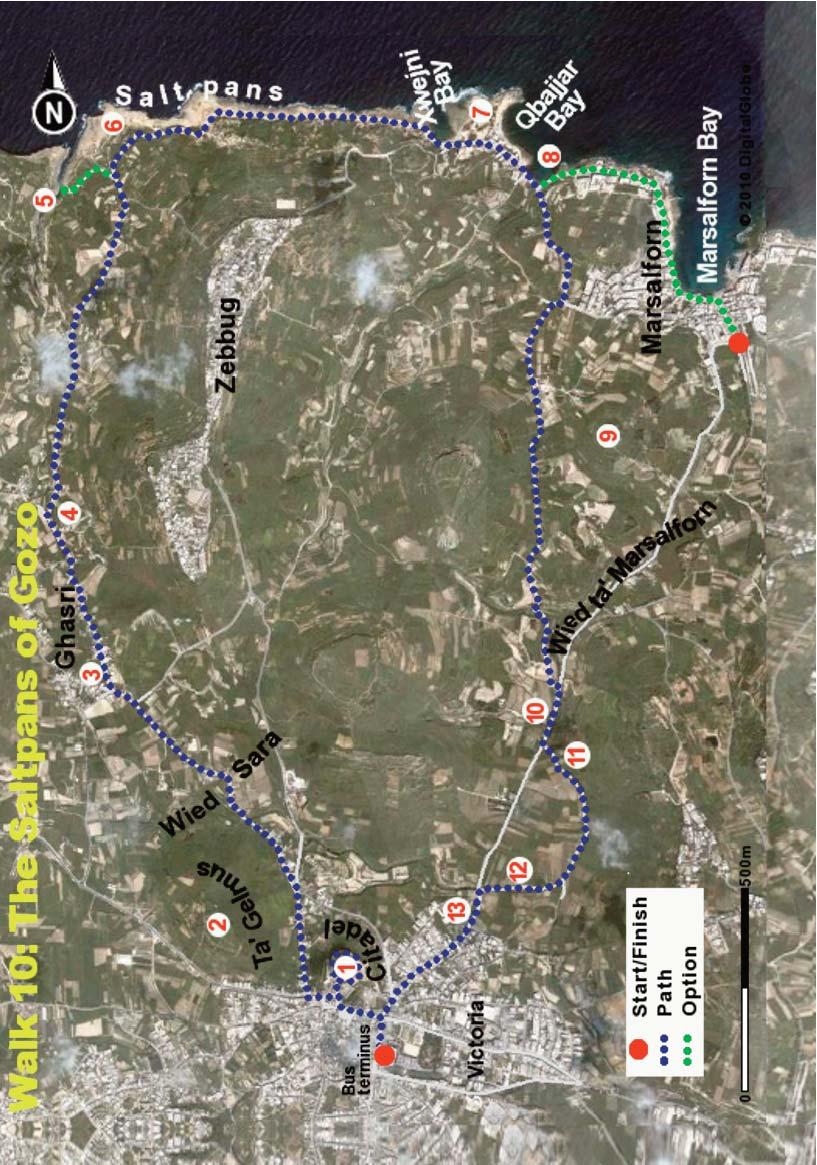
95

96 WALK 10 The Citadel The Citadel, with its cathedral and component buildings, is at the heart of Gozo s history and culture. It has obvious advantages for defence, being high on a hilltop and as far from the sea as is possible in Gozo. The first records of a fortified castle on the site go back to 1241 but there is archaeological evidence for much earlier use of the site. The Citadel withstood a siege of three days by Ottoman raiders in 1551, succumbing after the island s only gunner was killed. The present structure dates to the early 1600s when it was rebuilt by the knights in the form we see today. The Citadel contains strong bastions, small medieval streets, the old prison, the Museum of Archaeology and the imposing cathedral with its 17th century Baroque facade. Taking the path to the right on leaving the Citadel you will find yourself in Savina Square. From the square take the road (Ursula Str) to the right, sign-posted for Ghasri, and after a short distance take another turn to the right. You will find yourself walking out of town on the public road with the Citadel dominating your view to the right. Ahead of you, on a high plateau you see the town of Zebbug. After about 400 m take the turn to the left, in front of Brookie s Restaurant. You are now on Wied Sara Str (wied means valley) and ambling along a minor country road. This often narrow road is flanked by small fields, rubble walls hosting a variety of wild flowers and some beautiful modernised farmhouses. You will also see lots of prickly pear - a plant introduced to Malta from California around the end of the 19th century. You can admire the very ornate stonework on balconies, balustrades and at house entrances. Many of the houses have individual names, most favouring religious themes. Times were usually tough in Gozo; a little divine help was always welcome. 92 View from the Citadel
 in its strength, colour and composition.")
97 WALK 10 The large flat-topped hill on your left is Ta Gelmus, composed mainly of soft red sandstone (2). Limestone is the dominant rock in Malta and Gozo but there is considerable natural variation from place to place (and in depth) in its strength, colour and composition. The top layer of the Ta Gelmus hill is composed of a hard limestone which is more resistant to weathering by rain and so protects the underlying softer layer from erosion. You will see many such flat-topped hills in Gozo. To the left you get distant views of the aqueduct system that carried water to Victoria during the 19th century. You will also see cape sorrel, easily recognised through its small yellow flowers, which was introduced to Malta in 1811 as a garden flower. You pass over a small bridge which, in winter and spring, overlooks a small stream. This, like all streams on the island, dries up completely during the summer months. About 2 km out from Victoria you reach the outskirts of the village of Ghasri. On a corner you see a lovely ancient niche, built in 1773 (3). The niche depicts an angel visiting Our Lady and rests on a stone balcony supported on three pillars which creates a pleasing three dimensional effect. Take the road to the right of the niche (Triq il-knisja) which skirts the edge of Ghasri village and passes again into tranquil countryside. You ramble past a pumping station which provides potable water from an underground aquifer for public supply, and after perhaps 2 km you arrive at an ancient Basilica (4). This, Gozo s oldest Basilica, was built in 1739 on the ruins of an earlier church. Continue along the road to the immediate left of the church along the country road bordered with welltended fields. The soil is whitish due to the presence of limestone, and supports a variety of crops such as fruit trees, vegetables and cereals. The fields are very small and preclude the use of heavy machinery so that much of the work must be done by hard manual labour or with the use of small rotavators. Farming is a tough business in Gozo and there is limited interest among the younger generation in following the family tradition in this regard. Organic farming, with its need for more personal and manual attention to crops, would appear to be the way forward for agriculture in Gozo, with farmers concentrating on higher value quality products rather than commodities such as potatoes. The Niche 93
, a narrow gorge with high steep cliffs and a small shingle beach at its mouth.")
98 WALK 10 Ghasri Gorge Stay on this main path (ignoring turns to the right and left) until, as you come near to the sea you notice a path to the left turning downhill towards the sea. You have an option here of diverting down this path for a few hundred metres to admire the Ghasri Gorge (5), a narrow gorge with high steep cliffs and a small shingle beach at its mouth. You can notice the lush vegetation of the valley sides with spherical tree spurges and wild carrots dominating. If you take that option you must return to this junction and then continue on the main path which now curves to the right to run generally parallel to the sea. The well-tended fields are behind you and the path is flanked on both sides by uncultivated natural land with high bushes. After about 400 metres the path brings you down to the coast where you get your first view of the impressive saltpans (6). The low shelving limestone ledges are sculptured with hundreds of square or irregular hand-cut basins of diverse shapes and sizes. Wonderful and strange! This fascinating saltpan complex extends for about 1.5 km along the coast. While there are saltpans at several other locations in Malta and Gozo this is the largest and most impressive system and represents salt harvesting on an almost industrial scale. Salt pans have been used since Roman times as a means of harvesting salt from the sea. The basic process is simple to understand. Seawater is fed into the shallow depressions through a system of hand dug channels and, after concentration and evaporation by wind and sun during the hot summer months, the white sea-salt can be collected and bagged. Salt was a valuable commodity in earlier centuries, but became very cheap when large underground salt mines in Germany, Poland and other countries came into use. With evaporation from saltpans, the raw materials may be free but the production process is very labour intensive and is no longer commercially viable, although some sea-salt is still harvested in small quantities. You may go down onto the limestone pavement to have a close look at the saltpans and to try to figure out how they worked and the functions of the channels and the different types of basins. You can notice a circular well at the first batch of saltpans, excavated by a rich watchmaker intent on making money from salt. On windy days you can hear the splashing of waves from the depths of this well as it connects to an underground sea cave. It is best however to stay on the coastal path for most of the route. 94

99 Xwejni Bay Look behind you at the cliffs with the strange shapes created by wind erosion, a consequence of the variations in strength and composition of the limestone. This part of the coast faces north, and violent winter storms with high breaking waves can be both beautiful and threatening. Following the coastal path you come to Xwejni Bay and are surprised by the strange hillock (7) at the tip of the peninsula. The view across the saltpans and the shallow bay to the mound is almost surreal. The mound is composed of quaternary deposits which filled an ancient doline (a collapsed cave). As the doline eroded, the harder infilled material remained as an out-of-context hill. The water in the bay is shallow and there is a reef just offshore making this is a good place for diving and for those learning to dive. The peninsula separating Xwejni Bay from the adjacent Qbajjar Bay contains a battery built in 1716 to discourage invasion through these accessible bays. The battery, originally equipped with 6 guns, came into use again during World WaR II as an observation post to protect the small harbour of Marsalforn. The coast here is now somewhat overbuilt but does contain a number of cafés. The Horizon restaurant on the seafront is a good location for having a snack. Leaving Qbajjar Bay, the main path for this walk turns inland at the end of the bay (8). From this point you have the option of staying on the coastal path which takes you into the town of Marsalforn and from which you can take a bus (infrequent) into Victoria or possibly take a taxi directly to the ferry port. This path takes you through a garden at the sea shore and provides a lovely vista of Marsalforn Bay. Back to Victoria The main path is recommended as it leads you back to the Bus Terminus in Victoria through small peaceful valleys. Take the main road to the right heading inland for about 400 m and then, at a junction, turn to the right and then again immediately to the left to get onto a small country road, heading in the general direction of Victoria. This path takes you through peaceful countryside, with Zebbug on a plateau to the right. On the left you can observe a conical hill with a 12 m high concrete statue of Christ on top (9). As you ramble along by rubble walls and small fields you get a distant view of the Citadel on its safe hilltop perch. After perhaps 1.5 km on this path you come to an open reservoir fed by 95

100 WALK 10 a small stream in a valley. Turning to the left and going over a small bridge you meet the main road between Marsalforn and Victoria (10). Turn up towards Victoria and, passing by another water pumping station, cross over the road to take the first small road to the left. This curving path leads you through one of the most pleasant valleys in Gozo, with good biodiversity (11). In winter and spring there is a flowing stream by the path hosting a range of plants and animals, including the painted frog. There are a number of plants and animals which live in water in these islands, although one might think it unusual given the dry nature of the islands. Streams and ponds are colonised with fairy shrimps, the weird tadpole shrimp (which is considered a living fossil since it has been around for some 300 million years), water snails and a variety of insect larvae such as damselfly larvae. The stream and moist banks are home to attractive plants such as water crowfoots, starfruits and stonewort, together with an enormous array of microscopic life. In the fields one can note the familiar narcissi, gladioli and a variety of annuals such as the blue flowered borage. The trees such as aleppo pine, evergreen oak and the rare white poplar have encouraged the presence of a large number of small birds in the area After about 1 km you should look out for a rough earthen path (12) heading up a small slope to the right and which leads you back to the main road to Victoria. The path is difficult to recognise as it is not paved and gives the appearance of a path leading to a farmer s field. This path is just after a stone wall on the right and will return you, after about 250 m, to the main road. Take the public road up to Victoria passing by a Capuchin Friary on the right (13). It was rumoured that a secret tunnel constructed as a potential escape route from the Citadel led to this site! Continue walking straight uphill and after perhaps 5 minutes you will arrive again at the Bus Terminus. 96
Malta. ECCE Delegates and Kamra tal-periti. Excursions Programme May 2011
 ECCE Delegates and Kamra tal-periti Excursions Programme 03-08 May 2011 Malta This programme has been exclusively tailor made by On Site Malta for: ECCE Delegates and KAMRA TAL-PERITI Page 2 TUESDAY 3
MALTA THE JEWEL OF THE MEDITERRANEAN SEA
 MALTA THE JEWEL OF THE MEDITERRANEAN SEA 2018 Fabio Besta High School 13 th September- 14 th October MALTA MALTA IS AN ARCHIPELAGO OF THREE ISLANDS MALTA, GOZO AND COMINO- IN THE MEDITERRANEAN SEA. ITS
Year 6 SOCIAL STUDIES Time: 1 hour
 HALF YEARLY EXAMINATIONS Maria Regina College Scholastic Year 2017-2018 Year 6 SOCIAL STUDIES Time: 1 hour Name: Class: School: Read the following instructions carefully: Write your name, surname, your
Valletta Landmarks Tour
 Copyright by GPSmyCity.com - Page 1 - Valletta Landmarks Tour Valletta proudly boasts a number of breathtaking landmarks and monuments that will impress even the most well-traveled visitor. This huge city,
THE DIRECTORATE FOR QUALITY AND STANDARDS IN EDUCATION The Department for Curriculum Management Education Assessment Unit A Tour of Valletta
 THE DIRECTORATE FOR QUALITY AND STANDARDS IN EDUCATION The Department for Curriculum Management Education Assessment Unit 2015-16 A Tour of Valletta Fieldwork for Year 6 Primary Carried out by Fieldwork
The Battle of Quebec: 1759
 The Battle of Quebec: 1759 In the spring of 1759, the inhabitants of Quebec watched the river with worried eyes. They waited anxiously to see whether the ships of the French, or those of the British fleet,
GSE 50+ PROGRAMMES 2019 SAMPLE ACTIVITY PROGRAMME
 GSE 50+ PROGRAMMES 2019 SAMPLE ACTIVITY PROGRAMME CARNIVAL PROGRAMME : 1 ST TILL 15 TH MARCH WEEK 1 Arrivals From 13:00 till 00:30 - GOZO AFTERNOON TOUR + CARNIVAL in Gozo: We will travel to Cirkewwa Ferry
S4.2 FABLES, LEGENDS AND HISTORY
 S4.2 FABLES, LEGENDS AND HISTORY S4.2.3 We will look at a historical text based on evidence. A. The following extract is about a historical event, that is, an event that really happened. The Arrival of
European Science Foundation COST Action TU0701 Improving the Quality of Suburban Building Stock
 European Science Foundation COST Action TU0701 Improving the Quality of Suburban Building Stock Department of Building & Civil Engineering University of Malta INTERNATIONAL CONFERENCE MALTA, 7 th 8 th
Written by Peter Hammond Monday, 01 February :51 - Last Updated Wednesday, 27 September :32
 To view this article as a PowerPoint, click here. To listen to the audio, click here. 7 th October is the anniversary of the Battle of Lepanto, one of the most decisive naval battles in history, which
Canada s Contributions Abroad WWII
 Canada s Contributions Abroad WWII Battle of the Atlantic (1939-1945) Struggle between the Allied and German forces for control of the Atlantic Ocean. The Allies needed to keep the vital flow of men and
MALTESE HISTORY. A. The Early Years of the Order of St John in Malta. Form 3
 MALTESE HISTORY A. The Early Years of the Order of St John in Malta Form 3 1 Unit A.1 - The Granting of Malta and Tripoli to the Order of St John 1. The loss of Rhodes The Grand Master L Isle Adam and
INFORMATION FOR PARTICIPANTS
 HANDS ON EXPERIENCE FOR VET TRAINERS 22 nd to 24 th November 2016 INFORMATION FOR PARTICIPANTS Dear participants, We are happy to welcome you as participants for the VET Trainers meeting. We hope to spend
THE MALTA COASTAL WALK
 THE MALTA COASTAL WALK A WONDERFUL WALK AROUND THE ENTIRE COAST OF MALTA Jonathan Henwood and Emmet McMahon GREAT WALKS SERIES THE MALTA COASTAL WALK This 155 km walk takes you around the entire island
HALF YEARLY EXAMINATIONS 2015/2016 FORM: 3 History (Option) Time: Name: Class:
 Time: Name: Class:") Name: Class: G I R L S S e c o n d a r y S c h o o l L - I M R I E Ħ E L HALF YEARLY EXAMINATIONS 2015/2016 FORM: 3 History (Option) Time: 1.30 Ex 1: Study the list of the following events during the early
Name: Class: G I R L S S e c o n d a r y S c h o o l L - I M R I E Ħ E L HALF YEARLY EXAMINATIONS 2015/2016 FORM: 3 History (Option) Time: 1.30 Ex 1: Study the list of the following events during the early
Tourism diversification of the Malta destination
 Presentation to University of Westminster Tourism Studies students 26 October 2017 Tourism diversification of the Malta destination Dr. John Ebejer Institute for Tourism, Travel and Culture University
GOZO COLLEGE SECONDARY SCHOOL
 GOZO COLLEGE SECONDARY SCHOOL Half Yearly Exams 2017-2018 Subject: HISTORY GENERAL Form: YEAR 10 Time: 1h 30 min Name: Class: Page 1 of 12 1. Choose the right answer. 1. The Maltese islands came under
Car Hire Limassol. {carman_quicksearch}
 {carman_quicksearch} Limassol or Lemesos is the second-largest city in Cyprus, with a population of 228,000 (2008). It is the largest city in geographical size, and the biggest municipality on the island.
Valletta Harbour. Medical and Military History in Malta
 Valletta Harbour Medical and Military History in Malta 30th September 5th October 2018 Upper Barrakka Gardens, Valetta Malta s beauty is battle-scarred, thanks to the island s strategic position in the
TEACHING AND LEARNING EVENT 2:
 TEACHING AND LEARNING EVENT 2: TESTING, IMPLEMENTATING AND DISSEMINATING THE EPICC EDUCATIONAL GOLD STANDARD MATRIX IN SPIRITUAL CARE FOR PRE- REGISTRATION NURSING AND MIDWIFERY STUDENTS 24-28 September
Places of Worship Tour of Rhodes
 Copyright by GPSmyCity.com - Page 1 - Places of Worship Tour of Rhodes Rhodes has a great variety of religious buildings, many of which date back centuries. Mosques, Catholic churches, synagogues-- these
The North Africa Campaign:
 The North Africa Campaign: The Battle of El Alamein October 1942 General Rommel, The Desert Fox General Montgomery ( Monty ) North Africa Before 1942, the Axis suffered only 3 major defeats: Commonwealth
Valletta AN INSIDER S GUIDE TO MALTA S CAPITAL SAMPLE FULL OF LOCAL KNOWLEDGE
 FULL OF LOCAL KNOWLEDGE Valletta AN INSIDER S GUIDE TO MALTA S CAPITAL PERFECT GUIDE FOR: CRUISE PASSENGERS DAY VISITORS EXTENDED STAYS VALLETTA 2018 SAMPLE 1 ABOUT THE AUTHOR Hi there! I m Ed, a traveller-turned-expat
The Maltese Islands: Geography
 The Maltese Islands: Geography The Maltese Archipelago comprises a group of small low islands aligned in a NW-SE direction. At their extreme points the Maltese Islands fall within the following points:
D-Day. June 6th, 1944
 D-Day June 6th, 1944 The Move on to France Because the Germans were being fought in Italy, the allies planned to move forward with their plan to open up the western front in Europe The Plan Winston Churchill
S5.1.3 Important notes about Birgu. Research by Etienne Vella Għajnsielem
 S 5.1 The Old Cities S5.1.3 Important notes about Birgu. Research by Etienne Vella Għajnsielem Birgu is the oldest city in Cottonera. As a peninzula (a piece of land in the shape of a tongue over the sea)
From Sketch. Site Considerations: Proposed International Eco Research Center and Resort, Republic of Malta. Introduction.
 Vectorworks: From Sketch ToBIM Site Considerations: Proposed International Eco Research Center and Resort, Republic of Malta Introduction The client for this project is a North American corporation that
Burgos lies on the main highway from France to
 Burgos Then and Now: the Sierge of 1812 By Gareth Glover The Napoleon Series BURGOS IN 1812 Burgos lies on the main highway from France to Valladolid, at a point where the road south to Madrid forks off.
Positano the best walks
 Positano the best walks Walking behind the scenes of the world s most beautiful resort town including the complete Sentiero degli Dei TRIP NOTES 2018 Genius Loci Travel, 2018. All rights reserved. INTRODUCTION
Today. Unit Quiz When you are finished please do something quietly. Castles in the Middle Ages
 Today Unit Quiz When you are finished please do something quietly Castles in the Middle Ages ** Hand in all of your assignments for this last unit please The High Middle Ages (1066-1300) Population Power
HOST project Fit On Olive Trails
 HOST project Fit On Olive Trails Żejt iż-żejtun Marathon Tourist Package: Itinerary for Foreign Visitors Malta: Żejtun, Valletta and Surrounding Localities malta EXPLORE OUR WORLD Co-funded by the COSME
Major Battles During WWII Events that Changed the Course of the War
 The Battle of Britain Major Battles During WWII Events that Changed the Course of the War With all of Europe under its control, as the last hold out The English Channel is only at the most narrow point
The North African Campaign. War in the Desert Expands 12 July May 1943
 The North African Campaign War in the Desert Expands 12 July 1942 16 May 1943 1 Torch El Alamein 2 The Battle of El Alamein General Montgomery and the British 8 th Army Builds up and Trains Forces Restores
3/29/2017. The North African Campaign. War in the Desert Expands 12 July May The Battle of El Alamein. Torch.
 The North African Campaign War in the Desert Expands 12 July 1942 16 May 1943 1 Torch El Alamein 2 The Battle of El Alamein General Montgomery and the British 8 th Army Builds up and Trains Forces Restores
Essential Question: What is Hellenism? What were the lasting characteristics of the Roman Republic & the Roman Empire?
 Essential Question: What were the lasting characteristics of the Roman Republic & the Roman Empire? Warm-Up Question: What is Hellenism? Why was Alexander of Macedonia considered great? In addition to
Mediterranean Europe
 Chapter 17, Section World Geography Chapter 17 Mediterranean Europe Copyright 2003 by Pearson Education, Inc., publishing as Prentice Hall, Upper Saddle River, NJ. All rights reserved. Chapter 17, Section
Bell Ringer Which was NOT an area of discontent (being unhappy) in the Georgia Colony?
 in the Georgia Colony?") Bell Ringer 11-4-13 Which was NOT an area of discontent (being unhappy) in the Georgia Colony? A.Slavery B.Voting Rights C.The sale of rum and liquor D.Ownership of land Which was NOT an area of discontent
Bell Ringer 11-4-13 Which was NOT an area of discontent (being unhappy) in the Georgia Colony? A.Slavery B.Voting Rights C.The sale of rum and liquor D.Ownership of land Which was NOT an area of discontent
War Begins. p
 War Begins p. 758-763 War Begins September 1, 1939, Hitler sent his armies into Poland. Two days later, Great Britain & France declared war on Germany & WWII began. Sep. 1 Germany invades Poland Sep. 3
Effect of Geography on Ancient Greece. Chapter 4-1
 Effect of Geography on Ancient Greece Chapter 4-1 Greek Geography Greece is a peninsula that is covered by many mountains. Geography Continued. It is located in the heart of the Mediterranean Sea. The
TEKS 8C: Calculate percent composition and empirical and molecular formulas. World War I on Many Fronts
 World War I on Many Fronts Objectives Understand why a stalemate developed on the Western Front. Describe how technology made World War I different from earlier wars. Outline the course of the war on the
Section 2. Objectives
 Objectives Understand why a stalemate developed on the Western Front. Describe how technology made World War I different from earlier wars. Outline the course of the war on the Eastern Front, in other
w w w. d r a k e s - i s l a n d. c o m
 w w w. d r a k e s - i s l a n d. c o m 1 A Piece of History Named after Plymouth s most famous patron and situated in the heart of Plymouth Sound, Drake s Island has a rich history having been a religious
Med Celebration (New Year Cruise) At-A-Glance
 At-A-Glance") At-A-Glance See in 2016 with us in the comfort of the Viking Star. After an overnight in Rome and a gala New Year s Eve at sea, you can recover from the festivities as the ship cruises south along the
At-A-Glance See in 2016 with us in the comfort of the Viking Star. After an overnight in Rome and a gala New Year s Eve at sea, you can recover from the festivities as the ship cruises south along the
9/28/2015. The Gallipoli Campaign (Dardanelles Campaign) Including the Armenian Genocide. February December 1915
 Including the Armenian Genocide. February December 1915") The Gallipoli Campaign (Dardanelles Campaign) Including the Armenian Genocide February December 1915 The Downfall of Winston Churchill?? 1 2 Turkey Enters World War I on 28 October 1914 (Secret treaty
The Gallipoli Campaign (Dardanelles Campaign) Including the Armenian Genocide February December 1915 The Downfall of Winston Churchill?? 1 2 Turkey Enters World War I on 28 October 1914 (Secret treaty
The Spanish Armada. by: Austin Hartman
 The Spanish Armada by: Austin Hartman Was the Spanish Armada worth it for Philip II? Key People Philip II- King of Spain Queen Elizabeth I- Queen of England Sir Francis Drake- Loyal subject to Queen Elizabeth
The Alliance System. Pre-WWI. During WWI ENTENTE ALLIANCE. Russia Serbia France. Austria-Hungary Germany. US Canada. Italy CENTRAL POWERS
 WWI: The Great War? The Start of the War WWI started with the advance of the Germans into Belgium. The alliance system kicked into full steam. Confident that the Schlieffen Plan would lead to a quick takeover
Identify aspects that have changed and others that have remained the same in the old cities of the Maltese Islands.
 S 5.1 The Old Cities S5.1.2 Identify aspects that have changed and others that have remained the same in the old cities of the Maltese Islands. A. The old cities of the Maltese Islands To understand what
Fort Ticonderoga Carillon Battlefield Walking Trail Guide
 Fort Ticonderoga Carillon Battlefield Walking Trail Guide Copyright Fort Ticonderoga. Photo Credit Carl Heilman II Length: Approximately 1¾ mile Welcome to Fort Ticonderoga s Walking Trail Blue markers
EAQUALS Malta Handbook
 1 EAQUALS Malta Handbook 2 General Information Climate Malta's climate is typically Mediterranean and thus strongly effected by the sea. The Maltese Islands have a pleasantly sunny which avereges around
Mediterranean Islands small group tour. From $7,995 AUD. Malta & Sicily Mediterranean Islands small group tour. 10 Mar 19 to 22 Mar 19
 From $7,995 AUD Single $8,995 AUD Twin share $7,995 AUD 13 days Duration Europe Destination Malta & Sicily Mediterranean Islands small group tour 10 Mar 19 to 22 Mar 19 Mediterranean Islands small group
archeological site LOS MILLARES
 archeological site LOS MILLARES Aerial view of the plain of Los Millares between the Rambla de Huéchar and the River Andarax The archaeological site of Los Millares is located in the township of Santa
World Wonders. Introduction. Barnaby Newbolt STAGE. Chapter summary
 STAGE Barnaby Newbolt Introduction This ungraded summary is for the teacher s use only and should not be given to students. Chapter summary Chapter 1 (A world of wonders) introduces the idea of wonders.
Arrival. Our representative to meet the group on arrival at airport and escort to adapted transport. Transfers airport hotel airport.
 Arrival Our representative to meet the group on arrival at airport and escort to adapted transport Transfers airport hotel airport Luggage Handling Signage Assistance throughout the groups stay A welcome
The promotion of tourism in Wales
 The promotion of tourism in Wales AN OUTLINE OF THE POTENTIAL ADVANTAGES AND DISADVANTAGES OF ADVANCING CLOCKS BY AN ADDITIONAL HOUR IN SUMMER AND WINTER Dr. Mayer Hillman Senior Fellow Emeritus, Policy
The Great Malvern Town Centre Walk. The Great Malvern Alternative Town Centre Walk
 The Great Malvern Alternative Town Centre Walk This is an abridged version of walk 4, from the Pictorial Guide to the Malvern Hills Book Two: Great Malvern Available from the Tourist Information Centre,
Map of Malta, Gozo, Comino and some small islands. Only the three largest are inhabited.
 MALTA 11. - 15. JUNE 2011 Day 2 The we took the bus to Mdina. We stayed in Gzira Day trip to Mdina Map of Malta, Gozo, Comino and some small islands. Only the three largest are inhabited. Mdina lies centrally
The. History Walk. WWII Armaments factory
 The History Walk WWII Armaments factory 4.8-6.5 kilometres (3-4 miles) 2.5-3.5 hours Terrain: easy Can be slippery when wet No stiles Unsuitable for a pushchair/wheelchair Uses OS map 197 Parking: Pulborough
AFRICAN CIVILIZATION. The Kushite Kingdom in Upper Egypt and the Sudan
 AFRICAN CIVILIZATION The Kushite Kingdom in Upper Egypt and the Sudan The Kingdom of Kush The civilization of Kush thrived from about 2000 B.C.E. to 350 C.E. Kush and Egypt had a close relationship throughout
EXPLORE DISCOVER LEARN CONNECT ENJOY Unique holidays in North Cyprus with the local experts
 Vivid Cyprus is an established North Cyprus holiday and tour agency which offers a personalised service for its clients before and during their Northern Cyprus holiday. As one of the pioneers of responsible
Guided Notes - Persian & Peloponnesian Wars
 Guided Notes - Persian & Peloponnesian Wars The Persian Wars - 510-478 B.C.E Major Battles: Marathon, Thermopylae, Salamis, & Plataea The Persians: Led by Began creating one of the world s largest empires
The Building of Valletta Joseph Borg
 The Building of Valletta 1566 by Joseph Borg It is the 450 th anniversary of the foundation of Valletta. In 1565 Malta was in ruins after the Great Siege but the Order of Malta, under Grandmaster Jean
Use pages to answer the following questions
 Use pages 569-573 to answer the following questions 1.Why was winning the Battle of the Atlantic so crucial to the fortunes of the Allies? 2.Why was the Battle of Stalingrad so important? 3.Why did you
Chapter 7 Geography and the Early Settlement of Egypt, Kush, and Canaan
 Chapter 7 Geography and the Early Settlement of Egypt, Kush, and Canaan How did geography affect early settlement in Egypt, Kush, and Canaan? Section 7.1 - Introduction RF/NASA//Corbis This satellite photograph
The Rise of Rome. After about 800 BC other people also began settling in Italy The two most notable were the and the
 The Rise of Rome The Land and People of Italy Italy is a peninsula extending about miles from north to south and only about 120 miles wide. The mountains form a ridge from north to south down the middle
23 Triq Salvu Camilleri, Mellieha MLH MALTA tel: web: i travel Ltd Malta
 i travel Ltd Malta Excursion 1: Valletta & Harbour Cruise / Cultural Highlights Full Day Tour Today, it s time to discover Malta s capital city, Valletta! We start our tour with a licensed English speaking
A New Kind of War. Chapter 11 Section 2
 A New Kind of War Chapter 11 Section 2 Introduction Great War was the largest conflict in history up to that time Millions of French, British, Russian, and German soldiers mobilized for battle German forces
Remember from last class...
 The Onset of War! Remember from last class... The republic lasted for nearly 500 years and this period marked major expansion of Roman power. During this time, Rome became the leading power in the Mediterranean.
THE BLOCK HOUSE. A time where yesterday is not necessarily the day before today: but a past that no longer exists.
 THE BLOCK HOUSE Going around in Tell el Eisa, obvious to those who know where to go, you can cross small areas where there are still many relics from the period of the battles of El Alamein. Some of these
Greatest sieges. Greatest sieges
 Greatest sieges Greatest sieges Contents Introduction: To stand or fall #5 Leningrad The deadliest siege ever. Published at Petitcodiac Regional School May 2016 #4 Malta An island against an empire. #3
Cyrus the Great. A tolerant ruler he allowed different cultures within his empire to keep their own institutions. The Greeks called him a Law-Giver.
 The Persian Empire: Cyrus the Great A tolerant ruler he allowed different cultures within his empire to keep their own institutions. The Greeks called him a Law-Giver. 580 529 B. C. E. The Jews called
Riding Under The Shadow of the 8th Wonder of The World Cycling in Sigiriya. Discover The Ancient Fortress of Sigiriya on Two Wheels
 Sigiriya Cycle Tour Riding Under The Shadow of the 8th Wonder of The World Cycling in Sigiriya. Discover The Ancient Fortress of Sigiriya on Two Wheels SLDT/1702/CY03 Why should you book this trip? Sri
Valletta Harbour. Travelling Surgical Society of Great Britain and Ireland tour to Malta
 Valletta Harbour Travelling Surgical Society of Great Britain and Ireland tour to Malta 10 17 May 2019 A street in Mdina Malta s beauty is battle-scarred, thanks to the island s strategic position in the
Into the Modern Era Palmerston s Forts
 Into the Modern Era Palmerston s Forts The second half of the nineteenth century saw the emergence of a unified Germany and Italy, growing instability in Eastern Europe (the Austro-Hungarian and Turkish
Warm ups *What is unique about the status of Switzerland? *How Austria s history differed from that of Switzerland?
 Warm ups 12.07.2016 *What is unique about the status of Switzerland? *How Austria s history differed from that of Switzerland? Lesson Objective: *describe how Spain differs physically, economically, and
50+ Programme Package Price List
 www.english-malta.com #mygatewaytosuccess 50+ Programme Price List 2018 50+ Programme Package Price List All prices are in Euro ( ) and per Person per Week. Price includes General English Course 20 lessons
Fort Carillon/Ticonderoga
 Fort Carillon/Ticonderoga A P H O T O G R A P H I C H I S T O R Y B E H I N D T H E S T R A T E G I C K E Y T O B O T H B R I T I S H A N D A M E R I C A N V I C T O R I E S I N T H E N O R T H. S E V
KAMENETZ-PODOLSKI. 1/8, Lit.G, Igorivska str, Kyiv, tel./fax: bluechip.ua
 KAMENETZ-PODOLSKI 1/8, Lit.G, Igorivska str, Kyiv, 04070 tel./fax: +38 044 201-10-60 bluechip.ua Preliminary program. Day 1. Arrival to Kamenetz-Podolski Check in Breakfast Walking city tour fortress of
JAPAN S PACIFIC CAMPAIGN. Chapter 16 section 2
 JAPAN S PACIFIC CAMPAIGN Chapter 16 section 2 Surprise Attack on Pearl Harbor October 1940 the U.S. had cracked one of the codes that the Japanese used in sending secret messages. Which meant the U.S.
Gozo Island: Malta s best kept secret
 City Tourism Gozo Island: Malta s best kept secret ITM London St George's Church Gozo (joy in Castilian), is tranquil and unique, the island of myths and miracles. It is the smaller, sleepier and more
The Byzantine Empire
 Do not dwell in the past, do not dream of the future, concentrate the mind on the present moment. -- Buddha Name: The Byzantine Empire Aim: To what extent was the Byzantine Empire, the new Rome? Development
Aberdeen: Hong Kong's traditional harbour
 !"#$ Aberdeen: Hong Kong's traditional harbour!"#$%&'()*+,-.%/00 %&'()*+,-./0123 %&'()*+,-./0123.45( %&'()*+#,-./012345 %&'()*+,-./01234+5 %&'()*+,-./0123456 eçåö=hçåöef%&'()* %&'()*+,-./0123456 %&'()'*%+(),-./0
Rome is now the capital city of Italy. 2,000 years ago it was the centre of the Roman Empire. The Romans had a story to explain how Rome began.
 The Etruscans Rome is now the capital city of Italy. 2,000 years ago it was the centre of the Roman Empire. The Romans had a story to explain how Rome began. Twin boys, Romulus and Remus, were the sons
Cyprus and Greece. We spent time enjoying the views over the sea and slowly strolled back to the hotel to complete our introductory day.
 Cyprus and Greece We are traveling again, this time spending two weeks in the Eastern Mediterranean, first in Cyprus and then in Greece. We have visited both countries before but it has been about 20 years
St. Augustine Self-Guided Walking Tour
 ... The following is a PREVIEW SAMPLE of the St. Augustine Self-Guided Walking Tour Please purchase, download and print the rest of the St. Augustine Walking Guide Series by visiting: www.citywalkingguide.com/staugustine
Heritage Enterprise. Revitalizing urban life and cultural heritage in Paola and Valletta. By Dr Malcolm Borg
 Heritage Enterprise Revitalizing urban life and cultural heritage in Paola and Valletta By Dr Malcolm Borg This case study originally appeared in Cities for the future: Innovative and principles-based
DEFENCE AREA 73 FRESHWATER BAY
 DEFENCE AREA 73 FRESHWATER BAY 1. Area details: The defence area is 3½ miles from The Needles and 10 miles W of Newport. County: Isle of Wight. Parish: Freshwater. NGR: centre of area, SZ 346860. 1.1 Area
North Africa and Italy Campaigns
 North Africa and Italy Campaigns Why Fight in North Africa? The North African military campaigns of World War II were waged between Sept. 1940 and May 1943 were strategically important to both the Western
Nubia s Proximity to Egypt Equals a Lifetime of Egyptian Rule. Ancient Nubia is known for being Egypt s overlooked neighbor. Nubia is also known for
 Walker, Aleta CENG 105- WS Professor Peterson Cultural Analysis- Final Draft November 13, 2012 Nubia s Proximity to Egypt Equals a Lifetime of Egyptian Rule Ancient Nubia is known for being Egypt s overlooked
MOSE PROJECT: STATE-OF-THE-ART AND FUTURE DEVELOPMENT
 AIPCN-France Third Mediterranean Days of Coastal and Harbour Engineering Troisièmes journées méditerranéennes de génie côtier et portuaire 23/05/2013 Marseille MOSE PROJECT: STATE-OF-THE-ART AND FUTURE
Physical characteristics and biomes:
 Physical characteristics and biomes: Sahel region, bordering Sahara Characteristics Area suffers from lack of rainfall, over grazing, which causes loss of vegetation and loss of inhabitable areas causing
VALA MAR RESIDENCES THE REASON TO INVEST IN
 VALA MAR RESIDENCES THE REASON TO INVEST IN A L B A N I A This country is a dizzying mix of religion, styles, cultures and landscapes, from the Orthodox, Sunni, Muslim, Albanians, from idyllic beaches
CELTIC CRUISING ON TOUR - ALGARVE CRUISE 7 TH -13 TH SEPTEMBER 2019
 CELTIC CRUISING ON TOUR - ALGARVE CRUISE 7 TH -13 TH SEPTEMBER 2019 Portugal s warm southern coast offers an attractive combination of sunshine, easy cruising and sandy beaches to explore from the comfort
400 th Anniversary Romanov Tour 2013
 400 th Anniversary Romanov Tour 2013 This year s tour centred around the 400 th Anniversary of the Romanovs and included many new sights. Below are some of the highlights with a little bit of history.
YALTA-SEVASTOPOL-KIEV-LVIV. Tour program (10 days/9 nights)
") YALTA-SEVASTOPOL-KIEV-LVIV Tour program (10 days/9 nights) DAY 1 Arrival to Simferopol airport. Meeting and transfer to Yalta. Check-it to the hotel Bristol ***. DAY 2 09:30 18:00 Tour of Yalta today starts
YALTA-SEVASTOPOL-KIEV-LVIV Tour program (10 days/9 nights) DAY 1 Arrival to Simferopol airport. Meeting and transfer to Yalta. Check-it to the hotel Bristol ***. DAY 2 09:30 18:00 Tour of Yalta today starts
3 WEEKS LONG STAY IN MALTA
 3 WEEKS LONG STAY IN MALTA 2018-2019 LONG STAY MALTA Seashells Resort at Suncrest 4* Welcome to the new Seashells Resort at Suncrest 4*. A great 4* star located in Qawra and renown for fall and winter
SLOW ADVENTURE - CROATIA Self-Guided Hiking along the Dalmatian Coast Split to Dubrovnik
 SLOW ADVENTURE - CROATIA Self-Guided Hiking along the Dalmatian Coast Split to Dubrovnik Enjoy walking along ancient Greek, Roman, and Venetian trails while discovering the local culture and gastronomy
Important Peace Treaties from European History.
 Important Peace Treaties from European History. What was the Peace Treaty that established Catholic and Lutheran religions in Germany according to ruler of the region? 1 The Peace of Augsburg 1555. This
Mauritius Official name Population Form of governmen Total area Urban-rural population Head of state Life expectancy Head of government
 Mauritius Official name :Republic of Mauritius Form of government: Republic with one legislative house (National Assembly [691]) Head of state: President Ameenah Gurib-Fakim Head of government :Prime Minister:
HOST project Fit On Olive Trails
 HOST project Fit On Olive Trails Żejt iż-żejtun Marathon Tourist Package: Itinerary for Foreign Visitors Malta: Żejtun, Valletta and Countryside Walks and Bike Routes malta EXPLORE OUR WORLD Co-funded
GALLIPOLI THE WICKHAM CONNECTION
 GALLIPOLI THE WICKHAM CONNECTION The eight-month campaign which took place between 25 April 1915 9 January 1916 on the Gallipoli peninsula in the Ottoman Empire. It was one of the Allies great disasters