The Aislabie Walk A journey through picturesque landscapes Studley Royal Laver Banks Hackfall
|
|
|
- Marcia Marlene Sims
- 6 years ago
- Views:
Transcription
1 The Aislabie Walk A journey through picturesque landscapes Studley Royal Laver Banks Hackfall Mark Reid
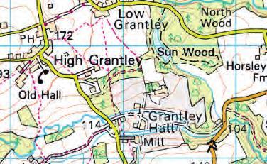
2 The Aislabie Walk WALK INFORMATION A journey through picturesque landscapes Studley Royal Laver Banks Hackfall Mark Reid Short route 7.5 miles (12 km) Allow 3 hours Medium route 11.5 miles (18.5 km) Allow 6 hours Long route 17.5 miles (28 km) Allow 8 9 hours Map OS Explorer Sheet 298 Nidderdale Start/Parking Lakeside car park (pay & display), Studley Royal Deer Park (Grid Ref: SE ). Refreshments Pubs, cafés and/or shops at Fountains Abbey, Galphay, Kirkby Malzeard and Grewelthorpe. Terrain Undulating tracks and paths through woodland, along riverbanks and across fields, with some stretches along quiet country lanes. Many of the paths are muddy underfoot. There are numerous stiles to cross. How to get there Fountains Abbey and Studley Royal lies to the west of Ripon just off the B6265. The Lakeside car park (Studley Royal Deer Park) is accessed via Studley Roger. Please note There are several roads to cross as well as short stretches of road walking. The woodland paths through Hackfall are muddy underfoot in places with one or two narrow sections where there are steep drops to the side of the path. You may encounter livestock in some fields THE WALK From the Lakeside car park (Studley Royal Deer Park) with your back to The Lake walk across the car park and follow the grassy path heading up a slight grassy gully (sign St Mary s Church, Visitor Centre ), passing mature trees and up onto the Deer Park where you carry straight on across the Deer Park to reach St Mary s Church and a lane across your path. Turn left along this lane and follow it up to soon reach a gate in the deer park boundary wall. After the gate head immediately left and follow the clear roadside path for 400 metres then, where the path forks just before you join the road (before the roundabout), follow the right-hand path to quickly reach the road. Cross the road and follow the grassy bridle-path opposite, which you follow to the left alongside a hedge and the road on your left. Follow this bridle-path straight on passing the roundabout beside the entrance to Fountains Abbey Visitor Centre then continue along the roadside path for a further 300 metres to re-join the road (just before the road bends right). Head straight on along the road for a short distance then cross over and take the stony track ahead just as the road bends to the right. Follow this track down to re-join the road. Turn left down along the road then, where this road bends sharp left (road chevron sign) turn right over a stile beside a gate (signpost). After the stile, follow the track straight on down to join the banks of the River Skell on your left. Follow this riverside track straight on to soon reach a gate across the track that leads into Spring Wood, beside an old stone bridge across the river. Head through the gate (ignore bridge) and follow the riverside track straight on heading up through the steepsided wooded valley of the River Skell, with the river on your left, following the sweeping curves of the river valley for 1.75 km through woodland and across open pastures (keep to the track and ignore bridges across the river) all the way to reach the ruinous stone buildings of Aldfield Spa, with its adjacent sulphur springs. Immediately before the ruinous buildings of Aldfield Spa, take the grassy path to the right that leads behind the buildings then, after a few paces, take the path up to the right that quickly leads up to join a clear, level path which you follow to the right heading back down through the valley (track you just walked along down to your right). Follow this path straight on, level at first then rising up across the wooded valley side to reach a stile at the top of the wooded bank. Cross the stile and walk straight on along a slightly sunken grassy path out onto a field. After a short distance this sunken path disappears bear left across the middle of the field (towards the buildings of Aldfield) and through a gateway in a fence/hedge, after which continue straight on across the field and through a gate in a fence to the left of the buildings/houses (edge of Aldfield) then walk straight on across the next field to reach a wrought-iron gate in a wall at the top of the field that leads onto the road at Aldfield. Turn right along the road into the centre of the village then take the footpath to the left through a kissing-gate 75 metres beyond Bay Tree Farm (opposite the phone box). After the kissing-gate, head across the field to quickly reach two stiles in quick succession on either side of a line of trees, after which bear left across the field to join the fence on your left. Follow this fence straight on across the field then, where this fence bends
.")
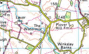
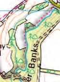
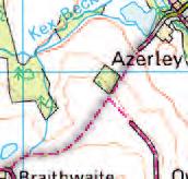
3 Mark Reid 4 slightly left as you approach the end of the field (line of telegraph poles), carry straight on (bearing away from the fence) to soon reach a stile over the fence/hedge, with Clip d Thorn Farm ahead of you. Cross the stile and walk on across the field to reach a gate that leads onto the road opposite Clip d Thorn Farm (signpost). Turn right along the road for a few paces then left immediately after the house over a stile (signpost) that leads across the gardens and driveway to reach a small gate in the corner of the small enclosure beside a wooden shed. After the small gate, head straight across the field bearing very slightly left (waymarker post) to reach a stile over a fence just before (and to the left of) North House. Cross the stile then walk across the small enclosure (house to your right) to reach a stile beside a gate, with views ahead across the Laver Valley towards Winksley Church. After the gate, walk straight down across the field to reach a stile in the bottom right corner then continue straight down across the next field to reach another stile in the bottom corner that leads into Winksley Plantation. Cross the stile and follow the narrow path straight on (fence on your left) down through trees/undergrowth to join a road. Turn right along the road for 300 metres through woodland then, just before the road bends up to the right, take the track off to the left. Follow this track straight on through woodland for 450 metres to reach a T-junction with another track (end of woodland). Turn left and follow the track (woodland on your left) for 250 metres to reach a fork in the track, where you take the lefthand track that leads down through woodland (Laver Banks) to reach Woodhouse Bridge across the River Laver. Short route: Turn right immediately after Woodhouse Bridge along a track and follow this riverside track/path (waymarkers) for 1.25 km meandering through woodland and across riverside pastures (keep to the riverside) all the way to reach Galphay Mill Bridge across the River Laver. As you reach this bridge, follow the field boundary round to the left (walking parallel with the road) for 50 metres to reach a gate to your right that leads onto the road. Turn right along the road, over Galphay Mill Bridge and follow the Route Description from Point 16. Cross Woodhouse Bridge and follow the track straight on, then climbing up through woodland to soon reach Wood House just to your right (top of the wooded bank) where you follow the track bending left to quickly reach a stile beside a gate that leads out onto a field. After the stile, bear diagonally to the right up across the middle of the field, passing through the top of a line of trees/old field boundary (this line of trees is rising up across the field), where you carry on to soon reach the corner of a hedge protruding into the field (waymarker). Carry straight on alongside this hedge on your Woodhouse Bridge left across the top of the field to reach a gate in the field corner (waymarker). Turn left immediately before this gate through a fence, and walk up across the field alongside the hedge on your right then, halfway up this field (where the hedge on your right bends slightly left in front of you), cross a stile by a gate in this hedge (waymarker). After the stile, turn right alongside the hedge on your right, quickly passing through a gateway in a fence/trees then continue straight on across the next field alongside the hedge on your right to reach a gate to your right just before the field corner. Do NOT head through this gate, but turn left back on yourself up across the field to reach a gate in the hedge on your left halfway up the field, after which turn right along a track that leads up to a gate in the top right corner of the field (Laver Banks Farm ahead). Turn right after the gate to reach a stile in the corner of the field. After the stile, walk straight on alongside the fence/hedge on your right to reach another stile in the corner of the field, then carry straight on down across the middle of the field to join a fence on your left halfway down the field (enclosure with small barns/sheds) which you follow straight on down to reach a stile, after which bear slightly left to reach another stile that leads onto a farm lane, with Skeaf House to your left. Cross the lane over the stile opposite then head straight down across the field and over another stile just beyond a small stream, after which head straight on alongside the fence on your right across two fields to join the road on the edge of Galphay. Turn left along the road and follow it winding through the village, passing the phone box (ignore turnings off) to reach the large village green (with its maypole) where you follow the road to the right towards Kirkby Malzeard passing the Galphay Inn then, where the roads bends sharp left as you reach the edge of the village (sports field on your left) head straight on off this bend through the ornate wooden gates of the Braithwaite Hall Estate (signpost). After the gate, follow the track straight on alongside the hedge on your right across parkland for 700 metres to reach a cattle grid across the track, with the buildings of Braithwaite Hall just across to your left. Medium route: Cross the cattle grid and walk along the track for a few paces to reach a crossroads of tracks. Turn right along the track and follow this straight on (lake down to your left) to soon reach a fork where you take the right-hand track curving gently to the right to soon reach a gate (clear track ends). Head through the gate and follow the grassy track straight on along the edge of the field to reach a bridlegate at the start of an enclosed track (Hubber Lane). Follow this enclosed tree-shaded bridleway straight on, which soon becomes a wider track that leads steadily down for 0.75 km to reach Mill Farm (track becomes a lane). Continue along the lane passing Mill Farm on your right down to reach a bridge/ford across Kex Beck at Azerley. Cross the bridge and follow the lane rising up the small bank to quickly reach a fork in the lane. Turn right along the lane to soon reach Azerley Grange Farm where you follow the Route Description from Point 14. Cross the cattle grid and walk along the track for a few paces to reach a crossroads of tracks where you follow the middle track straight on curving down to the left to reach a turning circle in front of Braithwaite Hall. Follow the track curving round to the right (ponds across to your right) the track soon becomes grassy underfoot and
 down to reach a gate")
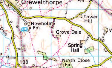
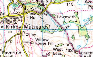
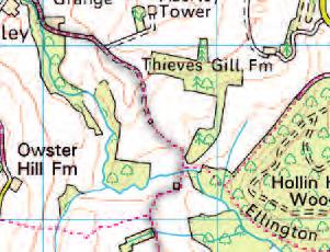
4 leads on through woodland to soon reach a choice of two gates at the end of the enclosed grassy track. Head through the right-hand gate, then walk straight across the middle of the field, keeping fairly close to the field boundary on your left (passing a small pond on your right) down to reach a gate in the fence/old hedge towards the bottom left corner of the field. After the gate head straight on to quickly join a clear track, which you follow straight on (to the left) for 0.5 km to reach the house and buildings of Lawnwith. As you reach the house, continue straight on along the lane for a further 350 metres to join a road. Turn left along the road, over Creets Bridge across Kex Beck and follow the road up into Kirkby Malzeard. As you reach the road junction beside the old Market Cross, turn right along the road towards Grewelthorpe, Masham and follow this down passing the church and school then winding steeply down (take care) to reach a couple of houses (old mill) set in a wooded valley and another bridge across Kex Beck. Cross the bridge and follow the road rising up for a few paces then take the path off to the right (signpost) climbing up through trees to quickly reach a stile that leads out onto a field. Head straight on across the narrow field to quickly reach another stile that leads onto a farm track, where you head straight on across the field to reach a stile over a fence, after which head straight on alongside the fence on your left, through a gate then continue on across the next field (following the fence/wall skirting to the right around the perimeter of Mowbray View house) to reach a stile over a fence/hedge in the corner of the field (beyond the house). After this stile, carry straight on across the large field alongside the hedge/fence on your left and through a gate in the field corner, after which continue across the next field and over a stile to the right of some barns/sheds. After this stile, head diagonally to the right up across the middle of the field to reach a stile in the far top corner of the field that leads onto the road on the edge of Grewelthorpe. Turn left along the road into Grewelthorpe, passing the village pond on your left and then the Crown Inn on your right, immediately after which (and before St James s Church) turn right along a lane. Follow this lane straight on heading out of Grewelthorpe, gently dropping down for 300 metres then, where it bends sharp right, take the footpath to the left over a stile through the hedge (signpost Hackfall ). After the stile, head to the left along the edge of the field (narrow path) keeping close to the hedge on your left to reach an old wall-stile in the corner at the end of the field. After the stile, head straight on across the next field then, just as you approach the end of this field, follow the path bending left through the hedge then immediately right to quickly reach a stile that leads into woodland (Hackfall). After the stile, head down to quickly reach a small bridge across Grewelthorpe Beck (at the head of the small valley), after which follow the path up then bearing round to the right over another bridge after a short distance (sign Fountain Pond and Follies) then follow the clear woodland path straight on heading through Hackfall, with the small valley of Grewelthorpe Beck down to your right (ignore rough path branching up to your left). After 400 metres you reach an obvious junction of paths/tracks (gate on your left), where you head straight on along the level path ahead (sign Ruin ) then gently rising up and bending round to the left (following the curve of the hillside) before climbing more steeply up to reach the impressive building of The Ruin (holiday cottage), set magnificently on the edge of a dramatic escarpment. As you approach the Ruin (holiday cottage), follow the path skirting to the left around this building (over stiles), to re-join the woodland path along the escarpment just beyond (alternatively, between 11am and 3pm, follow the path straight on across the Ruin Terrace). As you re-join the path just beyond the Ruin, carry straight on along the clear woodland path along the top of the escarpment heading away from the Ruin (views to your right) for 300 metres to reach a fork in the path. Follow the right-hand path (sign Fountain Pond ) winding quite steeply down the hillside to reach another fork, where you head to the right along the clear path heading down View from The Ruin Terrace across the wooded hillside to reach Fountain Pond. Follow the path straight on passing the Pond on your right (and the Rustic Temple folly on your left) to soon reach the Grotto folly (and Forty-Foot Fall to your right) where you continue down through the woods to reach a junction of paths by a small stream. Cross the stream then turn immediately left and follow this path to reach Fishers Hall (octagonal folly) set on a rise of land above the rapids of the River Ure. As you reach the folly, pass to the right of it and follow the path to the right down steps to join the wide riverside path (by a small ford). As you reach the riverside, follow the path to the right over the small ford (river to your left) and follow this meandering path through the woods, crossing small sidestreams, for 400 metres then gently rising up across the steep riverbank, with the river down to your left (passing the path to Mowbray Castle). The path then leaves the river behind and heads through dense woodland (river now out of sight across to your left) meandering through the trees for 0.75 km to reach a fork in the path (waymarker). Follow the right-hand path through the woods for a further 250 metres to reach a gate at the end of the woods. After the gate, turn immediately left to quickly reach another gate (muddy), after which walk straight on alongside the woodland and fence/hedge on your left heading across the field to reach a road. Turn right along the road for 150 metres then turn left along a track through a gate (signpost), just where the road bends up to the left. Follow this grassy track straight on along the foot of the small bank on your right heading through a shallow valley for 300 metres to reach a gate that leads into Coal Bank Wood. Head through the gate and follow the track (which soon becomes a path) straight on through woodland (stream to your left) for a further 700 metres to reach a gate at the end of the woods. After the gate, walk straight on alongside the fence/overgrown hedge WTPL/David Rodway
 for 100 metres then, where the road bends left (by the post-box), take the turning branching off to the right ( Dead End sign ignore driveway to the right beside")
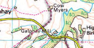
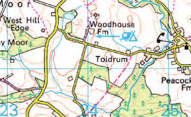
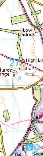
5 on your left across fields all the way to reach a road. Turn right along the road and follow it for 800 metres to reach a T-junction with another road. Turn left along this road (take care) for 100 metres then, where the road bends left (by the post-box), take the turning branching off to the right ( Dead End sign ignore driveway to the right beside the gatehouse) and follow this road for 0.5 km into the hamlet of Azerley. At the obvious fork in the lane (with a bridge across Kex Beck down to your right), turn left and follow the lane to soon reach Azerley Grange Farm where you continue along the lane (Kex Beck down to your right) to soon reach Home Farm. Carry straight on along the track passing the farmhouse then passing to the right of the large barns after which continue along the track for 400 metres to reach a fork in the track. Follow the right-hand track straight on for a further 300 metres to reach another fork, where again you follow the right-hand track (left hand track leads into woodland, marked private ) which heads down across the field for 300 metres to reach an old metal gate at the end of the clear track (stone table). After the old gateway, turn left along the indistinct grassy track alongside the field boundary on your left (overgrown intermittent hedge/trees) then, as you reach the end of the field, follow the indistinct track down to the right, through a gateway then straight on to reach a footbridge across Kex Beck. Cross the footbridge then walk straight across the field to reach Witch of the Woods House, surrounded by a small enclosure. Pass to the left side of the enclosure surrounding the house then turn right, following the enclosure round passing in front of the house then, where the enclosure ends, carry straight on bearing slightly left to reach a double gate in the fence at the end of the field. Head through the gate then turn left along the track and follow this through a series of gates to reach Cow Myers Farm (equestrian centre). As you reach the farmyard, carry straight on along the driveway passing immediately to the right of the farmhouse then follow this driveway away from the farm across fields to join a road. Turn left down along the road to reach Galphay Mill Bridge across the River Laver. Cross Galphay Mill Bridge and follow the road climbing up across the wooded Laver Banks then, as you emerge from the woods at the top of the bank (house on your left) turn right along a track (signpost) and follow this across fields for 1 km to reach Low Lindrick Farm. As you reach the farm, follow the track straight on passing to the left of the buildings, after which carry straight on along the driveway heading gently down across parkland for a further 0.75 km to reach the B6265 opposite the North Gate (Lindrick Gate) into Studley Royal. As you reach the road, turn right along the verge for a short distance then, just after the entrance to High Lindrick Farm (track and a roadside cottage), head left across the road and through the door in the deer park boundary wall (National Trust sign Fountains Abbey & Studley Royal ). After the doorway, follow the track to the left to soon join the metalled lane leading from the North Gate entrance. Turn right along this lane and follow it for 850 metres across the Deer Park to reach a crossroads of lanes, where you carry straight on down along the lane to reach The Lake. Follow the lane curving round to the right alongside The Lake back to the car park. THE AISLABIE WALK During the late 17th and early 18th centuries, there was a movement amongst the wealthy and well travelled to embrace, enhance and appreciate the natural environment, whereas previously it was viewed as a resource or, in more remote and mountainous areas, with fear. An ideological movement developed known as picturesque nature, where the natural landscape was enhanced to create a contrived and tamed wilderness that could be viewed and enjoyed by visitors using carefully planned follies, vistas and driveways. Interestingly, the word picturesque is derived from the Italian pittoresco which means in the manner of a painting. This nicely encapsulates the desire to create a landscape that was pleasing to the eye and composed in such a way as to replicate a landscape painting. The Aislabie family were at the forefront of this movement and influenced the future design of grand landscape gardens throughout this country and beyond. During the mid 18th century, William Aislabie established a circuit between his estates at Studley Royal and Hackfall with carriageways, bridges and vistas forming a private route for his family. The Aislabies created a vast picturesque landscape that included Studley Royal, Laver Banks and Hackfall. This circuit remained until the early 19th century thanks to the growing popularity of Hackfall and Studley Royal. Unfortunately by the late 19th century it had fallen out of use and the exact route has now been lost. However, there are enough clues and evidence to piece together much of this circuit, with a little artistic licence to fill in the gaps whilst also taking in some of the other fascinating points of historic interest along the way. It is not a historically accurate route, but more of a walking route that explores the historical landscape so you may experience the picturesque circuit of Studley Royal, Laver Banks and Hackfall as William Aislabie originally intended some 250 years ago. FOUNTAINS ABBEY & STUDLEY ROYAL In 1132 a group of thirteen Benedictine monks set off from St Mary s Abbey at York in search of a more austere way of life. They stayed at Ripon on Christmas Day before walking some four miles further west to an area of land in the valley of the River Skell given to them by the Archbishop of York. Despite its current gentle sylvan appearance, this remote wooded valley was said to be more fit for wild beasts than men to inhabit in It was on this land that the monks established Fountains Abbey, which became part of the Cistercian Order. It grew over the centuries into one of the richest and most powerful monasteries in Europe with vast tracks of land throughout the North of England from the Lake District to the North Sea. However, bad harvests and frequent Scottish raids during the 14th century brought about economic collapse. Despite its financial problems, Fountains Abbey remained of great importance with its Abbots sitting in Parliament. All this came to an abrupt end in 1539 with Henry VIII s Dissolution of the Monasteries; Studley Royal Andy Johnson

6 Mark Reid Aldfield Spa although Henry did give the Abbot and his monks generous pensions! Today, the ruins of Fountains Abbey are the largest remains of a Cistercian abbey in Europe. They are an outstanding example of Cistercian architecture, including well preserved sections of the precinct wall, an exceptional stone-vaulted Cellarium and one of the finest Cistercian corn mills in Europe. John Aislabie, MP and Chancellor of the Exchequer, inherited the Studley Royal estate in In 1720, he left office in disgrace for his part in the infamous South Sea Bubble financial scandal, and returned to Yorkshire to devote his time to his estate. Although an amateur, Aislabie transformed the wild wooded valley of the River Skell into a landscaped water garden with formal walks, vistas and water features. He also planted thousands of trees throughout the park. In 1731 he bought Hackfall, which his son William was later to develop as a 'wilderness' garden. After John s death in 1742, William continued and extended his father s work developing the estate in the fashionable naturalistic and picturesque styles of the time. Needless to say this contrasted sharply with his father s more formal gardens. In 1767 William purchased the adjacent ruins of Fountains Abbey and incorporated them into his landscape designs. Studley Royal Water Garden now stands as one of the most important Georgian water gardens in England with ponds, lakes, water features, Classical temples, statues and mature woodland. The Water Garden occupies 60 acres of the 760 acre Studley Park, which itself includes avenues of trees, planned vistas and driveways, and an extensive deer park where over 600 deer of three species (red, sika and fallow) roam across the magnificent parkland. Studley Royal Park, including the ruins of Fountains Abbey, was deservedly designated a World Heritage Site in ALDFIELD SPA From Fountains Bridge across the River Skell, a delightful track leads up through the deep wooded river valley passing through Spring Wood and Spa Gill Wood to reach the ruins of Aldfield Spa. The first section of this river appears to have been channelled with a finely built stone bridge. This stretch of the valley originally formed part of the landscaped gardens of Studley Park developed during the 18th century by the Aislabies. The ancient woodland is a delight in spring with its profusion of wild flowers including bluebells, wild garlic, yellow archangel, primrose, greater stitchwort and lesser celandine. Sulphur springs were discovered beside the River Skell below the village of Aldfield in the late 17th century, at a time when the healing properties of spa water were gaining popularity. Indeed, nearby Harrogate was one of the leading spas in the 18th and 19th centuries, with thousands of people flocking to this town to bathe in or drink the cure. The mineral waters were used for a variety of ailments from constipation to skin complaints. Aldfield Spa, as it became known, grew in popularity and soon had its own spa building and is shown on historic maps as Aldfield Spa Magnesia and Sulphur; indeed, in the early 1900s the water was piped all the way to Ripon to supply the newly-opened Spa Baths in the city. Sadly, spa treatments waned during the 1930s, and Aldfield Spa closed. The ruined spa buildings are still clearly visible, with a rare example of an 18th century wellhead nearby. Just across the river is another sulphur well, with a deep open well of water. The rotten egg smell is powerful it is amazing to think that people thought something so unpalatable must have been good for them! LAVER BANKS Between Fountains Abbey and Galphay, the River Laver flows through a deep and winding valley, its steep sides cloaked with trees. This is the famous Laver Banks, an area that was developed during the 18th century by William Aislabie to create a picturesque landscape between Studley Royal and Hackfall. He made good use of the vistas but never developed Laver Banks to the same degree as Studley or Hackfall. It is also believed that he built Woodhouse Mill with a terrace close by from where visitors could take in the views. Unfortunately, there is little surviving evidence to show exactly what the designed landscape of Laver Banks looked like back in the 18th century. GALPHAY Galphay is a beautiful village that lies amongst the rolling hills and meandering rivers between Ripon and Masham. Old cottages face out across a large village green complete with maypole. Close by is the famous Galphay Inn. The name of the village is believed to mean 'the enclosure of the gallows'. It is thought that the monks of Fountains Abbey also owned land in this area. BRAITHWAITE HALL This beautiful old farmhouse possibly dates back some 500 years, although it has been altered over the intervening years and extensively restored in the 1970s. It boasts an unusually large roof, elaborately carved lintels and a door halfway up the gable end, all of which give it the appearance of a gingerbread house. The cobbled farmyard is in perfect order and overlooks a small lake complete with island and resident wildfowl. KIRKBY MALZEARD Now there s a name Malzeard. There are not many, if any, other places with that name. It means poor clearing and is of Norman origin from the words mal assart. Kirkby Malzeard would have existed as a small village before the Normans arrived. Its present church was built on the site of a pre-conquest church and the name kirkby is Danish meaning the settlement by the church. Roger de Mowbray built his Norman castle in the village, although the only reminders of this fortress are overgrown earthworks. The castle was demolished in the 12th century on the orders of Henry I following an ill-fated rebellion when Roger de Mowbray joined a conspiracy with the Bishop of Durham to replace the King with his cousin, Prince Henry. St Andrew s Church dates back to 1150, although it was extensively restored in the 19th century and later severely damaged by fire in The church is well worth a closer look. This lovely old building has many interesting features including an impressive


7 WTPL/Michelle Davies Norman doorway with three rows of zigzags, Norman stonework around the base of the 16th century tower, and Norman sundial remains above the entrance porch. Look out for mice, of the wooden variety, amongst the Mousey Thompson furniture. Edward I granted John de Mowbray a market charter in With its castle and imposing church, Kirkby Malzeard developed into a busy market town with regular markets held until The market cross in the centre of the village dates from 1886 and replaced a medieval one. Today, Kirkby Malzeard is a quiet village with many fine old stone houses, a variety of shops, two pubs, and its own cheese factory. GREWELTHORPE Thorpe is a Scandinavian word meaning small settlement. Grewelthorpe embodies this in every sense. It is an attractive village of old stone cottages and farms facing out across a large village green, at the heart of which is a pond that is home to friendly and inquisitive ducks. There has been a village here since at least the 9th century, with evidence of settlement in this area dating back to prehistoric times. Interestingly, a complete skeleton of a Roman soldier was found on Grewelthorpe Moor many years ago giving rise to the belief that there may have been a Roman camp nearby, possibly at Camp Hill where there is an ancient earthwork. Grewelthorpe once boasted two inns but the Hackfall Inn closed several years ago. The Crown Inn dates back to the early 17th century when it served as a coaching inn, and is an excellent place to call in to rest weary legs before venturing into the nearby woods at Hackfall. HACKFALL Hackfall lies just outside the village of Grewelthorpe, an extensive area of semi-natural ancient woodland that cloaks the steep banks of the River Ure. It is an absolute delight to explore the maze of paths that criss-cross this woodland, especially in spring when the ground is carpeted with bluebells and wild garlic. Hackfall was bought by John Aislabie in 1731, who most famously laid out the formal water gardens of Studley Royal. His son William transformed Hackfall into a romantic wilderness garden with trees, walkways, waterfalls, surprise views and follies. Hackfall has provided inspiration for many of our great artistic minds, including Turner who came here to paint, and William Wordsworth who recommended a visit to the woods en route to the Lake District. Hackfall featured on the Grand Tour itinerary during the 1800s and also on a Wedgwood dinner service made for Catherine II of Russia! The area had been neglected for many years and looked destined for redevelopment when The Hackfall Trust and the Woodland Trust stepped in and acquired Hackfall on a long term lease in Thanks to generous grant funding of almost 1 million from the Heritage Lottery Fund in 2006, many of the original Aislabie Mowbray Castle, Hackfall garden features have now been restored. Hackfall now has Grade I registered status due to its importance as a designed garden, whilst the flora and fauna of the woods make it a Site of Special Scientific Interest. It has also been awarded the Europa Nostra Award for conservation. The whole of the walk through Hackfall is a delight, but one of the highlights includes The Ruin set magnificently on the edge of the steep escarpment known as Mowbray Point. From here there are wonderful views across the Vale of Mowbray towards the North York Moors, not to mention the tree canopy of Hackfall beneath your feet with its scattering of follies and water features. There is also a fine view towards Mowbray Castle set on the escarpment across the side-valley of Grewelthorpe Beck. This is another of William Aislabie s follies built to resemble a ruined medieval castle that was designed as an eye catcher to add texture to the view. The Ruin was built in 1767 by William Aislabie as a Banquet House, with its eastern facade developed to look like the ruined arches of a Roman bath house. The Ruin has been restored by The Landmark Trust and is used as a holiday cottage. Below The Ruin, set amongst the trees is Fountain Pond and Rustic Temple. The large fountain in the pond is fed by an ingenious gravity water system whereby its tank is filled with water from a natural spring high up on the hillside then, when a certain level is reached, a valve opens and up shoots the fountain. This gravity-fed system takes around minutes to refill. A short walk down from the Pond is the Grotto, with fine views of the Forty-Foot Fall. The path continues down to reach the octagonal Fisher s Hall, set impressively above some rapids along the River Ure. Note the datestone and initials WA 1750 ; this was the first folly built by William Aislabie at Hackfall. The walls of this building are decorated with tufa and broken glass fragments, an original 18th century feature. Below this folly, our route follows the riverside path through Hackfall, a delightful combination of trees, flowers, birdsong and tumbling water. The recent restoration and engagement work at Hackfall has been made possible due to grants from the Heritage Lottery Fund, Nidderdale Area of Outstanding Natural Beauty, Yorventure and North Yorkshire Aggregates Grant Scheme. AZERLEY This was once an important township with a grange, or monastic farm, belonging to Fountains Abbey. Over the centuries the population has slowly dwindled so that it is now just a handful of scattered farms and cottages set amongst the mature trees and ornamental lakes of Azerley Park. From Azerley, a track leads past farms to reach the isolated Witch of the Woods House (private). This 17th century cottage is situated in a small, wooded enclosure in the middle of a field, a remarkable survival of an old country cottage, without electricity or mains water. When I first visited this house in 1997, it was falling into ruin and certainly lived up to its name; however, since then it has been restored and is once again habitable, although I would not like to stay here on a dark, windswept winter s night! Witch of the Woods house Mark Reid


8 Reproduced by permission of Ordnance Survey on behalf of HMSO. Crown copyright and database right All rights reserved. Ordnance Survey Licence number AL
9 The Aislabie Walk A journey through picturesque landscapes Studley Royal Laver Banks Hackfall If you would like more information on Hackfall, and other woods to visit nearby, you can find thousands of wonderful woods at VisitWoods.org.uk woodlandtrust.org.uk/hackfall The Woodland Trust, Kempton Way, Grantham, Lincs, NG31 6LL The Woodland Trust is a charity registered in England and Wales and in Scotland. A non-profit making company limited by guarantee. Registered in England No The Woodland Trust logo is a registered trademark. Woodland Trust (2011) /11 Cover images, clockwise from top right: The Ruin from Fountain Pond, Hackfall: WTPL/Paul Mosley; Hackfall woods: WTPL/David Rodway; The path to The Grotto, Hackfall: WTPL/Michelle Davies; Studley Royal: Andy Johnson; Deer at Studley Royal: Richard Jemison; Walkers at Aldfield Spa: Mark Reid
Beautiful Walks from the Blue Ball Inn
 Walk No. 5 RIVER VALLEYS AND MOOR Countisbury, Watersmeet, Hillsford Bridge, Cheriton, Shilstone Hill, Rockford and Chiselcombe. 8.5 MILES APPROX. Walking time four and a half hours approx. OS 1;25,000
Leaden Boot Challenge 2016 ROUTE INSTRUCTIONS
 Leaden Boot Challenge 2016 ROUTE INSTRUCTIONS Section 1 Alstonefield to Ilam (CP2) From the village hall car park turn R then L and pass through the village keeping to the R to enter Church Street. Pass
Leaden Boot Challenge ROUTE INSTRUCTIONS
 Leaden Boot Challenge ROUTE INSTRUCTIONS Section 1 Alstonefield to Ilam From the village hall car park turn R then L and pass through the village keeping to the R to enter Church Street. Pass the Church
The Mendip Way. Route Directions and Maps Uphill to Wells
 The Mendip Way Route Directions and Maps Uphill to Wells Website: www.mendiphillsaonb.org.uk Email: mendip@mendiphillsaonb.org.uk Facebook & Twitter: @MendipHillsAONB Phone: 01761462338 1 Uphill to Loxton
Beautiful Walks from the Blue Ball Inn
 Walk No. 2 WINSTONS WALK Countisbury, Wind Hill, Watersmeet, Ash Bridge and Winston s path. 5 Miles approx. Walking time- Two and a half hours approx. (Not including Breaks) OS 1:25,000 Sheet 64/74 Lynton
ID: 283 Distance: 6.2 miles Height gain: 500 Metres Map: Explore OL 19 Contributor David and Chris Stewart
 Walkingworld Wild Boar Fell ID: 283 Distance: 6.2 miles Height gain: 500 Metres Map: Explore OL 19 Contributor David and Chris Stewart Features Birds, Great Views, Hills or Fells Description: Wild Boar
Pontfadog. Walk A. Walk A
 Walk A A Bird s eye view of the village 2km. (1 1 /2 miles); height gain 45m. (150ft) about 45 minutes. Six minutes walk along the main road towards Glyn Ceiriog reach a signpost to Llwynmawr. Take the
BISHOPSTONE CIRCULAR WALK
 BISHOPSTONE CIRCULAR WALK 4½ miles (7¼ km) - allow 2 hours (see maps on final pages) Introduction This walk is within the North Wessex Downs Area of Outstanding Natural Beauty and starts from the small,
CWMGIEDD FROM ABERCRAVE
 Abercrave to Cwmgiedd Walk Page 1 Starting from The Abercrave Inn. Grid Ref: SN 824128 From the Abercrave Inn, an 11.3km (7 miles) walk to the foothills of the Cribarth Mountain, then through forest to
Hay Wood, Rowington and Baddesley Clinton - Warwickshire
 Hay Wood, Rowington and Baddesley Clinton - Warwickshire Starts at Lay-by alongside Hay Wood 2 hours 30 minutes 5.5miles 8.8km Leisurely ID: 0.683 Developed by: John Clift Checked by: Andy Page www.ramblersroutes.org
Bewl Water & the High Weald
 1 Bewl Water & the High Weald Stonegate station - Stonegate - Wallcrouch - Newbarn - Cousley Wood - Wood's Green - Wadhurst station Length: 9 ½ miles (15.3km) Underfoot: Large portions of this path are
The Bridestone Rocks from Lydgate
 Print this page Back to results The Bridestone Rocks from Lydgate Ancient tracks and gritstone outcrops, with terrific views of the steepsided Cliviger Valley. Distance 5 miles (8km) Minimum time 2hrs
Self-Guided Walk Malham, Gordale and Malham Tarn
 Self-Guided Walk Malham, Gordale and Malham Tarn Combine all the major geological attractions of Malham in this walk and hopefully leave enough time to enjoy the cafes, pubs and shops of the village. Malham
Beamers Trail. Walk No.1. 6 miles. (easy with some moderate ascents and descents)
") Beamers Trail Walk No.1 6 miles (easy with some moderate ascents and descents) 1 BEAMERS TRAIL 6 miles (easy with som WALK The Warpers Trail forms part of the long distance Witton Weavers Way. This is
Beamers Trail Walk No.1 6 miles (easy with some moderate ascents and descents) 1 BEAMERS TRAIL 6 miles (easy with som WALK The Warpers Trail forms part of the long distance Witton Weavers Way. This is
Hindhead, Keffolds Copse and Gibbet Hill
 point your feet on a new path, Keffolds Copse and Gibbet Hill Distance: 6 km=4 miles Region: Surrey Author: Schwebefuss Refreshments: Punch Bowl Café moderate walking Date written: 14-apr-2015 Last update:
Aeron & Arth walks 4 walks for all the family to enjoy
 Aeron & Arth walks walks for all the family to enjoy Please take note that the maps illustrating these walks are intended as a rough guide only. You should use the most recent version of the relevant Ordnance
Ystwyth and Rheidol Bridleway Routes. Route 2:Llanilar Circular
 Ystwyth and Rheidol Bridleway Routes Route 2:Llanilar Circular Route overview and terrain: A long circle using connecting ridges with fine views to link the Rheidol and Ystwyth river valleys. The route
Walk 1: Highfield, Lob Wood and The River Wharfe
 Walk 1: Highfield, Lob Wood and The River Wharfe Start: The Hen Pen Garden, Main Street, Addingham LS29 0NS, SE 077 498. Alternative Start: Near Bolton Bridge SE 071 525 (see page 6). Full walk: 4.5 miles
Ardingly Lake, Ouse Valley, Borde Hill
 point your feet on a new path Ardingly Lake, Ouse Valley, Borde Hill Distance: 14 km=9 miles or 12½ km=8 miles Region: West Sussex Author: Hautboy Refreshments: Borde Hill Map: Explorer 135 (Ashdown Forest)
HARDMOORS 55 RACE ROUTE 2018 HELMSLEY - GUISBOROUGH
 HARDMOORS 55 RACE ROUTE 2018 HELMSLEY - GUISBOROUGH HELMSLEY - CHECKPOINT 1 (WHITE HORSE) 1. Leave RACE START, continue ahead on road (Baxtons Sprunt) At crossroads turn right down Canons Garth eventualy
3.1 Bowness-on-Solway to Carlisle
 3.1 Bowness-on-Solway to Carlisle Map panel 1 Distance 15 miles (24 km) Terrain minor roads, tracks, field paths and riverside footpath, muddy in places Grade easy, with gentle gradients on undulating
Approximate distance: 4.5 miles For this walk we ve included OS grid references should you wish to use them. Start. End
 Approximate distance: 4.5 miles For this walk we ve included OS grid references should you wish to use them. 2 1 Start End 4 3 N W E S Reproduced by permission of Ordnance Survey on behalf of HMSO. Crown
Description for the Round Rotherham 8 December 2007
 Directions: L left R right ½L, ½R half left, half right X cross X Rds cross roads SA straight Codes: BR bridge FP footpath FB footbridge RWY railway CP car park RD road Description for the Leave Event
Freefolk and Whitchurch
 Trail Activity Type Terrain Author Distance Ascent Location : HAMPTR0026 : Walk : Tea Shop : Towpaths and Cycle Tracks : Jean Patefield : 5.6 miles / 9 kms : 377 feet / 115 metres : SU487488 / RG28 7NN
Woodland Walk If you enjoyed this walk there are two others available in the same area.
 The Woodland Walk 11-12 kilometres (7-8 miles) 4-5 hours Terrain: some easy hills Can be slippery when wet 5 stiles Unsuitable for a pushchair/wheelchair Uses OS map 197 Parking: Pulborough Station and
Slad over to Pitchcombe and back
 The walk climbs up from Slad over Wickridge Hill, descends to near Pitchcombe, then climbs back over Wickridge hill and round the back of Slad. Page 1 Start Point: SO 8718 0732 The Woolpack, Slad Length:
BURGHCLERE PARISH RIGHTS OF WAY
 BURGHCLERE PARISH RIGHTS OF WAY Full descriptions compiled by Neill & Miggie Bruce All photos Miggie Bruce FP23 on Ridgemoor, looking south, with FP22 crossing by the bush FP1. From C183 Aldern Bridge
A Circular Walk from Chapel Carn Brea
 A Circular Walk from Chapel Carn Brea 4.3 Miles A Walk Visiting Five Historic Ancient Sites This circular walk offers the possibility of several alternatives, depending on the walker s available time and
GRINDLEFORD GALLOP 2018
 GRINDLEFORD GALLOP 2018 Route Information The Grindleford Gallop follows a fixed 21 mile route through the lanes and paths of Derbyshire. All competitors must follow this route. An OS map of the area with
Walk 1. Cotswold Water Park. Gateway Centre to Cerney Wick, railway track to Lake 6, Gateway Centre.
 Cotswold Water ark Walk way A Swindon/ Cirencester Thomas and Severn Canal way to Cerney Wick, railway track to Lake, way. Spine Road East Hotel Time: hours (short walk km) Distance: km A level walk along
HARDMOORS ROUTE DESCRIPTION
 HARDMOORS 60 2016 ROUTE DESCRIPTION RACE START (GUISBOROUGH) - CHECKPOINT 2 (SALTBURN) DISTANCE 9 MILES CUT OFF TIME 1030 GRID REF OS 666 208 1. Leaving the Sea Cadets Hall, turn left onto the road and
The Great Malvern Town Centre Walk. The Great Malvern Alternative Town Centre Walk
 The Great Malvern Alternative Town Centre Walk This is an abridged version of walk 4, from the Pictorial Guide to the Malvern Hills Book Two: Great Malvern Available from the Tourist Information Centre,
Approximate distance: 7.5 miles For this walk we ve included OS grid references should you wish to use them.
 Approximate distance: 7.5 miles For this walk we ve included OS grid references should you wish to use them. 6 5 7 8 4 1 2 Start End N 3 W E S Reproduced by permission of Ordnance Survey on behalf of HMSO.
Aston Rowant Discovery Trail
 The walk was developed by Aston Rowant Parish Council. The Trail is stile-free and fully way-marked. The circular route is 5.3m but with the extension to a pub and hotel 6.2m. Key Main Aston Rowant Discovery
Self-Guided Walk Langdale Pikes. Start & Finish: NT car park (free to members) at Sticklebarn - on the right just beyond the New Dungeon Ghyll hotel.
 at Sticklebarn - on the right just beyond the New Dungeon Ghyll hotel.") Self-Guided Walk Langdale Pikes Key Information These mountains form a collection of spires and cliffs on the north side of Langdale. This walk visits four of the main tops Pavey Ark, Harrison Stickle,
Self-Guided Walk Langdale Pikes Key Information These mountains form a collection of spires and cliffs on the north side of Langdale. This walk visits four of the main tops Pavey Ark, Harrison Stickle,
Chevening and the North Downs
 1 Chevening and the North Downs Dunton Green station - Chipstead - Chevening - Knockholt - Hawley's Corner - Botley Hill - Oxted station Length: 12 ¼ miles (19.7 km) Underfoot: Portions of the walk are
Mapledurham, Gallowstree and Shepherd s Green
 Mapledurham, Gallowstree and Shepherd s Green Pangbourne station Mapledurham Gallowstree Common Satwell Shepherd s Green Grey s Court Henley-on-Thames Length: 15 ½ miles (24.8km) Underfoot: Minor roads
The Hundred Parishes
 The Hundred Parishes Walks from railway stations number 3 3 miles (5kms) circular walk from Stansted Mountfitchet Start & finish: Stansted Mountfitchet station. Ordnance Survey Explorer Map 195. Grid Reference:
Singleton and the South Downs
 point your feet on a new path Singleton and the South Downs Distance: 13½ km=8½ miles easy walking with a few steeper sections Region: West Sussex Author: Hautboy Refreshments: Singleton, Hill Barn Date
Ranmore Common and Polesden Lacey
 point your feet on a new path Ranmore Common and Polesden Lacey Distance: 9½ km=6 miles Region: Surrey Author: Fusszweig Refreshments: Polesden Lacey easy walking Date written: 20-dec-2016 Last update:
Britain s oldest surviving water-balanced cliff lift
 44 3.6 Saltburn by the Sea to Sandsend Map panels 3 and 4 Distance 17 miles (27½ km) Terrain mostly grass and field paths which can be muddy; some pavement, beach and shore Grade undulating route, with
Horden. A walk of nature...sea and history
 Horden A walk of nature......sea and history 182 283 A181 Wingate B1287 Peterlee Seaham Easington B1281 Newcastle Horden Blackhall A179 Newcastle International Airport Crimdon A1086 Location... Horden
Hadleigh Castle and Chalkwell Oaze
 1 Hadleigh Castle and Chalkwell Oaze Benfleet station Hadleigh Park Hadleigh Castle Leigh-on-Sea Chalkwell station A short stroll through the lush woods of Hadleigh Park high above the Thames-side marshes,
COWAL WAY MULTI-USE ACCESS NOTES
 COWAL WAY MULTI-USE ACCESS NOTES The Cowal Way is a 57 mile long distance path. Starting at Portavadie, it winds its way up through the Cowal peninsula via Tighnabruich, Glendaruel, Strachur, Lochgoilhead
Morning Copse near Maidstone, Kent acres of Ancient Woodland with a pond, bluebells and mature oak. 26,500 (freehold)
") WOODS 4 SALE Phone: 01248 364 362 www.woods4sale.co.uk UK Woodland & Woods For Sale: Specialising in the Sales of Small Woodlands in England, Scotland and Wales for Recreation, Wildlife Conservation and
WOODS 4 SALE Phone: 01248 364 362 www.woods4sale.co.uk UK Woodland & Woods For Sale: Specialising in the Sales of Small Woodlands in England, Scotland and Wales for Recreation, Wildlife Conservation and
Lewes and the South Downs
 point your feet on a new path and the South Downs Distance: 0 km=1½ miles moderate walking with long easy stretches Region: East Sussex Author: Hautboy Refreshments: Date written: 8-apr-013 Map: Explorer
landcapes and romance Artists and poets have been inspired by the idyllic scenes of picturesque Kent villages sheltered by rolling, chalk hills.
 landcapes and romance Artists and poets have been inspired by the idyllic scenes of picturesque Kent villages sheltered by rolling, chalk hills. WALK 4 41 41 WALK 4 42 Pond Location: Distance: 5 miles
Fetcham Downs and Bocketts Farm A magical teashop walk
 point your feet on a new path Fetcham Downs and Bocketts Farm A magical teashop walk Distance: 3 km=2 miles or 4 km=2½ miles Region: Surrey Author: Fusszweig Refreshments: Bocketts Farm easy walking Date
Medway Valley Orchards
 1 Medway Valley Orchards East Farleigh station - Kettle Corner - Farleigh Green - Buston Manor - Yalding - Yalding station Length: 6 ¾ miles (10.9km) Underfoot: Generally, this is a walk on good paths,
11 Majors Barn. 19 Mill Street Exploring Abergavenny
 11 Majors Barn 19 Mill Street Exploring Abergavenny Cover: Mill Street from Monmouth Road 2 mill street EXPLORING ABERGAVENNY For several years the Abergavenny and District Civic Society has been studying
From the car park go through the wooden gate and walk to a large information board and wooden totem pole ahead of you.
 Trail Dave Price, Geograph (CCL) Twin peaks What are these striking wooded hills here in an otherwise flat landscape? Time: 40-60 mins Distance: 1 ¼ miles Landscape: rural Standing at over 300 feet tall
Lordenshaw. What are cup & ring marks?
 Lordenshaw Lordenshaw hill has one of the largest clusters of ancient cup and ring marked stones in the UK. We ve chosen four interesting spots we d like to share with you. What are cup & ring marks? The
Approximate distance: 4.7 miles For this walk we ve included OS grid references should you wish to use them. Start. End
 Approximate distance: 4.7 miles For this walk we ve included OS grid references should you wish to use them. Start End 1 2 3 4 N 5 W E S Reproduced by permission of Ordnance Survey on behalf of HMSO. Crown
This path goes past an old tree nursery and sawmill. After 800m it crosses over a lane. Follow the bridleway fingerpost into the woods.
 FRENSHAM PONDS 11K CIRCULAR TRAIL 2½ HRS GU10 2DA This magnificent heathland trail starts in woodland and then brings you out onto the open heather of Frensham Common, with no roadwork! The route runs
Chess & Gade. Chalfont & Latimer Station - Latimer - Chenies - Sarratt - Kings Langley Station. Length: 8 ¾ miles (14.25km)
") 1 Chess & Gade Chalfont & Latimer Station - Latimer - Chenies - Sarratt - Kings Langley Station Length: 8 ¾ miles (14.25km) Underfoot: Well-trodden paths, mainly firm in all weather conditions, though
1 Chess & Gade Chalfont & Latimer Station - Latimer - Chenies - Sarratt - Kings Langley Station Length: 8 ¾ miles (14.25km) Underfoot: Well-trodden paths, mainly firm in all weather conditions, though
Penn Common and Bramshaw Wood
 Trail Activity Type Terrain Author Distance Ascent Location : HAMPTR0025 : Walk : Pub : Towpaths and Cycle Tracks : Anne-Marie Edwards : 5.3 miles / 8.5 kms : 381 feet / 116 metres : SU253173 / SP5 2BZ
Brick House MAMHEAD EXETER DEVON
 Brick House MAMHEAD EXETER DEVON Brick House MAMHEAD EXETER DEVON A magical Grade II* listed house with planning to dramatically improve if required, with its own vineyard Accommodation and amenities
WALES Sample Itinerary
 WALES Sample Itinerary WELCOME TO WALES a Wales a Mother nature shaped Wales as a country full of visual drama and splendour. Clinging to the western edge of England, Wales is green and ruggedly beautiful,
Welcome to Priory Quay
 Welcome to Priory Quay Moments from the busy Dorset town of Christchurch, nestled between the magnificent Priory church and waters of Christchurch Harbour lies the marina development of Priory Quay. Comprising
Eglwyseg Mountain a landscape of prehistoric cairns and later industry
 Eglwyseg Mountain a landscape of prehistoric cairns and later industry Walk Information: Maps: OS Explorer 256 Distance: 5.3 miles / 8.5 kilometres (linear) or up to 9.6 miles / 15.5 kilometres (circular)
The 34 th Poppyline Marathon
 The 34 th Poppyline Marathon Saturday 9th June 2018 - Route Description Emergency number: 07906 404673 or 07597 052572 Ahd - Ahead BL - bear left BR - bear right BW - bridleway Cont - continue FB - footbridge
Warpers Trail. Walk No miles. (Easy with a few, short steep ascents)
") Warpers Trail Walk No.4 8.5 miles (Easy with a few, short steep ascents) 4 WARPERS TRAIL 8.5 miles (easy with a WALK The Warpers Trail forms part of the long distance Witton Weavers Way. This walk combines
Warpers Trail Walk No.4 8.5 miles (Easy with a few, short steep ascents) 4 WARPERS TRAIL 8.5 miles (easy with a WALK The Warpers Trail forms part of the long distance Witton Weavers Way. This walk combines
Basingstoke Canal and Dogmersfield
 point your feet on a new path? Basingstoke Canal and Dogmersfield Distance: 11 km=7 miles easy ing or 2 s of 7½ km=4¾ miles and 5¼ km=3¼ miles Region: Hampshire Author: Botafuego Refreshments: The Barley
Brucklay Castle, Maud, Aberdeenshire
 Brucklay Castle, Maud, Aberdeenshire Brucklay Castle, Maud Aberdeenshire A chance to restore an historic Castle in North East Scotland Maud 2 miles Aberdeen 29 miles Full planning and Listed Building consent
Much of the information which follows is included by kind permission of the Tynedale Council (now defunct) and is based on its brochure.
 and is based on its brochure.") The Tyne Green Trail This easy going circular walk is on level ground throughout. It follows the course of the River Tyne between Hexham Bridge and the turning point just past Watersmeet. The return is
The Tyne Green Trail This easy going circular walk is on level ground throughout. It follows the course of the River Tyne between Hexham Bridge and the turning point just past Watersmeet. The return is
As pretty as a picture
 43 As pretty as a picture Discover this enchanting stroll through classic Kentish countryside and peaceful Plaxtol. Shipbourne Village Green 44 44 Shipbourne Crown copyright 0009238. St Giles Church Location:
For more information and to buy this book click here ISBN: CICERONE. Guides for walkers, trekkers, mountaineers, climbers and cyclists
 For more information and to buy this book click here ISBN: 9781852844103 CICERONE Guides for walkers, trekkers, mountaineers, climbers and cyclists www.cicerone.co.uk SALÈVE AND VALLÉE VERTE SALÈVE WALK
Merritts Traverse. 1928m
 Merritts Traverse 3 hrs Hard track 5.8 km Circuit 4 167m This walk starts with a scenic journey to the top of the hill on the chairlift. Starting along Merritts Nature walk, this walk soon detours down
London to Oxford Trek map
 London to Oxford Trek map Route stats: 103.6 km (64.4 miles) with 800 metres of climbing Start time: 08:00-09:00am Checkpoints: Start - Spelthorne Leisure Centre TW18 1AJ Distance: 0km (0m) Leave here
Tacklers Trail. Walk No miles. (A walk with a couple of short steep slopes and some rough moorland paths)
") Tacklers Trail Walk No.3 9.5 miles (A walk with a couple of short steep slopes and some rough moorland paths) WALK 3 TACKLERS TRAIL 9.5 miles (moderate wi 1. Sunnyhurst Visitor Centre The Warpers Trail
Tacklers Trail Walk No.3 9.5 miles (A walk with a couple of short steep slopes and some rough moorland paths) WALK 3 TACKLERS TRAIL 9.5 miles (moderate wi 1. Sunnyhurst Visitor Centre The Warpers Trail
River Isla B951. Diarmid s Tomb
 3. 4 Spittal of Glenshee to Kirkton of Glenisla Distance 14.6 miles 23.5 km Terrain mainly on rough moorland path with boggy bits and stream crossings, then heading east along at the B951 for 2.5 miles,
Gomshall station - Abinger Hammer - Abinger Common - Friday Street - Leith Hill - Coldharbour - Holmwood station
 1 To Leith Hill Gomshall station - Abinger Hammer - Abinger Common - Friday Street - Leith Hill - Coldharbour - Holmwood station Important note: this walk cannot currently be done wholly by train on a
Delamere Loop. The. Useful Businesses Equestrian Escapes Tailor-made horse riding holidays in Cheshire. Tel:
 The Loop Accommodation Providers Akesmere Bed & Breakfast OS Grid Ref. SJ589/669 B&B for horse and rider. Chester Road, Little, Tarporley, Cheshire CW6 9ER Tel: 01829 760348 www.akesmerefarm.co.uk Useful
Reigate Hill and Gatton Park
 point your feet on a new path Reigate Hill and Gatton Park Distance: 11½ km=7 miles easy-to-moderate walking or 2 walks of 6½ km=4 miles and 5½ km=3½ miles Region: Surrey Author: Schwebefuss Refreshments:
Sponsored by. statestreet.com
 /STATESTREETISLANDWALK #ISLANDWALKJSY Sponsored by statestreet.com Important Information If you forget everything else PLEASE remember the following.» Remember to check OUT of every checkpoint» If you
Mill Farm Azerley Ripon North Yorkshire
 Azerley Ripon North Yorkshire Azerley Ripon North Yorkshire HG4 3JJ Ripon 4 miles, Harrogate 16 miles, Leeds 32 miles, A1(M) 10 miles Classic Yorkshire farmhouse with traditional buildings, land and beck
Prospect House Bilton Lane, Harrogate, HG1 4DH
 Prospect House Bilton Lane, Harrogate, HG1 4DH 1,465,000 Prospect House, Bilton Lane, Harrogate, HG1 4DH 5 Detached 3 Harrogate is a spa town in North Yorkshire, England. Historically in the West Riding
Gomshall station - Abinger Hammer - Abinger Common - Friday Street - Leith Hill - Coldharbour - Holmwood station
 1 To Leith Hill Gomshall station - Abinger Hammer - Abinger Common - Friday Street - Leith Hill - Coldharbour - Holmwood station Important note: this walk cannot currently be done on a Sunday due to the
The Sudbury Branch Walks 1-4
 The Sudbury Branch Walks 1-4 Sudbury Branch Walks From Sudbury to Marks Tey The gentle declivities, the luxuriant meadow flats sprinkled with flocks and herds... the sound of water escaping from the mill
Crimdon. A walk of nature...sea, sand and countryside
 Crimdon A walk of nature......sea, sand and countryside A182 B1283 A181 Wingate B1287 Peterlee Seaham Easington B1281 Newcastle Horden Blackhall A179 Newcastle International Airport Crimdon A1086 Location...
Pen Cerrig-calch prehistoric cairns
 Walk Information: Maps: OS Explorer OL13 Distance: 8 miles / 13 kilometres Duration: Allow at least 6 hours for the circular walk Difficulty: medium. Some narrow paths, occasionally rough underfoot Start
Approximate distance: 5.5 miles For this walk we ve included OS grid references should you wish to use them. Start. End
 Approximate distance: 5.5 miles For this walk we ve included OS grid references should you wish to use them. Start End 2 1 5 4 6 3 N W E 7 S Reproduced by permission of Ordnance Survey on behalf of HMSO.
START - UPHILL BEACH. (tidal!) The West Mendip Way is route-marked with these round blue signs
 The West Mendip Way is route-marked with these round blue signs") START - UPHILL BEACH Start Times: 10:30 11:15 12:00 Please allow sufficient time to check in with the marshals Start on the beach at the high water line (tidal!) The West Mendip Way is route-marked with
START - UPHILL BEACH Start Times: 10:30 11:15 12:00 Please allow sufficient time to check in with the marshals Start on the beach at the high water line (tidal!) The West Mendip Way is route-marked with
29 Plas Derwen. Exploring Abergavenny
 29 Plas Derwen Exploring Abergavenny Cover: rhythm 2 plas derwen EXPLORING ABERGAVENNY For several years the Abergavenny and District Civic Society has been studying the streets, spaces and buildings of
Gors Lydan barrows and medieval huts
 Walk Information: Maps: OS Explorer 214 Distance: 5.5 miles / 9 kilometres Duration: 4.5 to 5 hours Difficulty: Easy. Good paths and no steep gradients Start and finish: SO 11977545 Walk summary The walk
Scenic Railway to Ruined Castle
 Scenic Railway to Ruined Castle 7 hrs 30 mins 12.4 km Return Hard track 4 963m This is a very popular, full day walk, in the Katoomba Area, offering great views of the valley. The walk follows the edge
Weatherman Walking Welshpool Approximate distance: 4 miles Start End
 Approximate distance: 4 miles For this walk we ve included OS grid references should you wish to use them. 4 3 2 1 Start End 5 6 N W E S Reproduced by permission of Ordnance Survey on behalf of HMSO. Crown
Legal, financial and property specialists NEWFARGIE PH2 9QT
 Legal, financial and property specialists GLENFARG BALVAIRD VIEW NEWFARGIE PH2 9QT BALVAIRD VIEW Pagan Osborne is delighted to offer this modern detached bungalow located within the charming semi rural
From castle to county town
 From castle to county town A self guided walk around Warwick Explore how Warwick has developed over the last thousand years Visit the town s historic landmarks and hidden treasures Find out how the streets
Key Information. Self-Guided Walk Corfe Castle to Swanage
 Self-Guided Walk Corfe Castle to Swanage A classic walk from the pretty village of Corfe Castle. Enjoy extensive views whilst walking along the wide ridge to the popular seaside town of Swanage, returning
Map: Landranger #27 Forres and Nairn and 36 Grantown and Aviemore
 THE DAVA WAY This is a newly created long distance route that runs from Forres to Grantown, mostly following the old railway line. You will need to detour around a couple of sections that are not really
Cragg Vale to Todmorden
 Cragg Vale to Todmorden Map Co-Ordinates : SE 002232 The Te Duem Stone near Stoodley Pike symbolises a long tradition of wayfaring. Crossing the the Pennine Way, the route drops down towards Lumbutts and
Vision for Kirkholt. Our proud history. From ancient knights to Victorian landmarks
 Vision for Kirkholt Our proud history From ancient knights......to Victorian landmarks Take the family heritage trail to discover historical gems on your doorstep See map inside FREE STICKERS! The Vision
The. History Walk. WWII Armaments factory
 The History Walk WWII Armaments factory 4.8-6.5 kilometres (3-4 miles) 2.5-3.5 hours Terrain: easy Can be slippery when wet No stiles Unsuitable for a pushchair/wheelchair Uses OS map 197 Parking: Pulborough
SHEEPLEAS. Visitor Guide and Self-guided Trails
 SHEEPLEAS Visitor Guide and Self-guided Trails Sheepleas The Sheepleas is an interesting mix of woodland, scrub and open grassland, situated on the chalk of the North Downs. This diversity of habitats
Baggy Point, Croyde, North Devon
 Baggy Point, Croyde, North Devon A walk using the South West Coast Path that is likely to be suitable for people with impaired mobility or with a pushchair, wheelchair, or mobility scooter. The Coast Path
Eastbourne. Alfriston 3¾ 6 3¾ 6. Birling Gap. Exceat
 3.8a Alfriston to Eastbourne (footpath) Map panel 6 (page 64) Distance 10½ miles (17 km) Terrain valley walk initially, first along riverbank path then hillside paths above, including stretch through forest;
Ivinghoe Beacon and the Grand Union
 1 Ivinghoe Beacon and the Grand Union Cheddington station - Horton Wharf - Ivinghoe - Ivinghoe Beacon - Bridgewater Monument - Aldbury - Tring station Length: 11 ¼ miles (18.3km) Underfoot: The first mile
Blue House Farm MATTINGLEY, HAMPSHIRE
 Blue House Farm MATTINGLEY, HAMPSHIRE Blue House Farm BOTTLE LANE, MATTINGLEY, HAMPSHIRE Farmhouse set in the centre of approximately 96 acres with extensive equestrian and agricultural buildings including
Congewai Track Head (East) to Watagan Headquarters
 to Watagan Headquarters") Congewai Track Head (East) to Watagan Headquarters 7 hrs Hard track 17.2 km One way 4 973m This full day walk starts from the Congewai valley trackhead (east) and follows the Great North Walk up into the
Congewai Track Head (East) to Watagan Headquarters 7 hrs Hard track 17.2 km One way 4 973m This full day walk starts from the Congewai valley trackhead (east) and follows the Great North Walk up into the