THE BEGINNINGS Of THE RESEARCH Of SLOVENIAN ALPS ZAČETKI RAZISKOVANJA SLOVENSKIH ALP
|
|
|
- Elmer Shepherd
- 6 years ago
- Views:
Transcription
1 Geografski vestnik 88-2, 2016, Reviews/Razgledi REVIEWS/RAZGLEDI THE BEGINNINGS Of THE RESEARCH Of SLOVENIAN ALPS ZAČETKI RAZISKOVANJA SLOVENSKIH ALP AUTHORS/AVTORJA dr. Pe ter Mikša UniversityofLjubljana,FacultyofArts,DepartmentofHistory,Aškerčevacesta2,SI 1000Ljubljana, Slovenia dr. Ma ti ja Zorn ResearchCentreoftheSlovenianAcademyofSciencesandArts,AntonMelikGeographicalInstitute,Gosposka ulica13,si 1000Ljubljana,Slovenia DOI: /GV88206 UDC/UDK:910.4:94(497.4) COBISS:1.02 ABSTRACT The be gin nings of the re search of Slo ve nian Alps Ninetyyearsago,JožeRus(1926)publishedanarticleinthejournalGeografskivestnikentitled»Triglav: HistoricalandGeographicalSketches«.Ninedecadeslater,wewishtoshedlightonthehistoryofthe»discovery«andstudyofSlovenianmountains,focusingonthe»classic«researchofthe17thand18thcenturies. Webrieflypresentthemotivationsfortheir»discovery«andthemainactors.SelectedcartographicpresentationofSlovenianmountainsfromthatperiodarealsobrieflypresented. KEYWORDS geography,historicalreviews,mountainresearch,mounttriglav,alps IZVLEČEK Začetki ra zi sko va nja slo ven skih Alp PreddevetdesetimiletijeJožeRus(1926)v Geografskevestnikuobjavilčlanekz naslovom»triglav:historijsko-geografske črtice«. Po devetih desetletjih želimo ponovno osvetliti zgodovino»odkrivanja«in preučevanjaslovenskihgoras poudarkomna»klasičnih«raziskavahv 17.in18.stoletju.Nakratkopredstavljamovzgibezanjihovo»odkrivanje«inglavneakterje.Nakratkosopredstavljenitudiizbranikartografski prikazislovenskihgorategaobdobja. KLJUČNEBESEDE geografija,zgodovinskipregledi,preučevanjegora,triglav,alpe ThearticlewassubmittedforpublicationonMarch21,2016. Uredništvojeprispevekprejelo21.marca
.")
2 Pe ter Mikša, Ma ti ja Zorn The be gin nings of the re search of Slo ve nian Alps 1 Introduction Ninety years ago, Jože Rus (1926) published an article in the journal Geografskivestnik entitled»triglav: Historical and Geographical Sketches«, and a few years later its sequel (Rus 1929/30; partly Rus 1933). After that the journal never again published any topics connected with the history of the»discovery«and study of Slovenian mountains. Generally speaking, broader topics connected with the mountains were rare; the only ones worth mentioning are the Alpine pasture economy (Vojvoda 1970), the upper forest line (Lovrenčak 1971; Plesnik 1971) and the mountain farms (Kerbler 2003; 2008). Also rare were historical reviews in other fields (e.g. Habič 1989; Gams 1990; Perko and Zorn 2008; Zorn and Gašperič 2016). Nine decades later, we wish to shed light on the history of the»discovery«and study of Slovenian mountains, focusing on the»classic«research of the 17th and 18th centuries. We briefly present the motivations for their»discovery«and the main actors. In the past, people visited and settled the mountains for a number of reasons, either because the lowland areas were overpopulated, for the purposes of farming (Alpine dairy farming), hunting, searching for ore, exploiting the forests, or to retreat from invaders. These people were mostly shepherds, hunters, ore seekers and herbalists, who were familiar with the nearby mountains and experienced much more there than is included in the sparing reports (historical sources). They went there anonymously without those close to them knowing and without leaving any written traces (Mikša 2013, 391). The Alps and other mountains have been dividing peoples since the dawn of time. They were also the homes of the gods and were best avoided. People feared the mountains because they did not understand the natural phenomena that were more intense there than in the valley below. How could one not be in awe of the»stony desert«ascending high into the sky, the steep rockwalls, the jagged glaciers, where a»small«weather hazard can turn into a life-threatening situation. It must be pointed out that Figure1:ChapelofSaintMaryoftheSnowsonVelikaplaninamountainplateauinKamnik-Savinja Alps(1,560 m);behindmountojstrica(2,350 m). MATIJAZORN 104

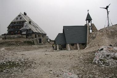
3 Geografski vestnik 88-2, 2016 Reviews/Razgledi MATIJAZORN SLOVENIANALPINEMUSEUM Figure2:ChapelofSaintMaryoftheSnowsandKredaricahut(2,515 m)inthejulianalpsatthe beginningofthe20thcentury(upperfigure)andtoday(lowerfigure). 105
4 Pe ter Mikša, Ma ti ja Zorn The be gin nings of the re search of Slo ve nian Alps the»taboo«was mostly the peaks of mountains, but only those that were high enough. The criterion was not their altitude but the natural geographic conditions (Mikša 2013, 391). Mountain peaks as homes of the gods can be found in almost every pagan mythology Olympus was the dwelling of the Greek gods, Kajlas is still a holy mountain of the Hindus and the Tibetans, and Triglav was said to be the home of a three-headed god according to old Slavic beliefs (Šaver 2005, 101). The Bible likewise did not deny the mountains the respect they deserve. One can quickly think of the importance of Mount Sinai (Zorn and Komac 2007), Mount Gilboa and others. Believers think that we are closer to God in the mountains. The significance of mountains in the spiritual sense has been preserved to this very day. One of the oldest mountain pilgrimages and the oldest preserved text about climbing a mountain is the ascent of nobleman Bonifacio Rotario D Asti on 1 September 1358 to the summit of Mount Rocciamelone (3,538 m) above the town of Susa in Italy. He carried a heavy brass triptych with the image of the Virgin Mary to the top of the mountain as a token of his gratitude for surviving Turkish enslavement. Nowadays, believers are still going on pilgrimages to see this image. The Virgin Mary is the protector of many Christian shrines in the mountains (Figure 1). Her statues or paintings have been placed on the peaks of La Meije and Aiguille du Dru in France, on Dom and Matterhorn in Switzerland (Engel 1950) and, last but not least, the chapel on Mount Kredarica (Figure 2), which is dedicated to Saint Mary of the Snows, was erected by Jakob Aljaž in 1896 (Mikša 2015, 121). In the older history of visits to the mountains the most famous story of all is most likely that of Hannibal s crossing of the Alps in 218 BC from modern-day France to the Apennine Peninsula. In the case of this and a few subsequently recorded crossings, such as the winter crossing of Mont Cenis (France) by Holy Roman Emperor Henry IV, who travelled to Pope Gregory IX in 1076, or the pilgrimage of the English monk John de Bremble, who crossed Saint Bernard between modern-day Switzerland and Italy on his way to Rome in 1178, the ascent was not connected with the admiration or research of the mountainous world (Mikša and Ajlec 2015, 11). In all probability, the same can be said for the oldest recorded crossing (by»ötzi«), which was carried out approximately 5300 years ago in the Ötztal Alps; according to one explanation, it was connected with trade (LeBlanc and Register 2003, 4; The Iceman 2016). Visiting the mountains out of necessity is probably as old as humanity itself, whereas other motives are much younger. The»honour«of the first recorded ascent for recreational purposes or» inthe desiretoreacha significantheight «(Kugy 1976, 23), and not out of necessity, belongs to the mediaeval poet Francesco Petrarch, who ascended the 1,912 metres high Mount Ventoux in Provence in 1336 with his brother and two servants. Some call this ascent the origin of mountaineering for it is believed to denote a shift in the attitude towards mountains. At a time when his contemporaries were avoiding mountains, he» wasthefirsttoascenda mountainforthemountainitselfinordertoenjoytheview «(Coates 1998, 65 66). However, according to Coates (1998, 65 66), on the summit Petrarch became engrossed in the Confessions of Saint Augustine which warn people not to confuse the creation and the creator, and not to be seduced by the landscape. For this reason, he became ashamed of what he had done. Also famous is the ascent by Leonardo da Vinci, who conquered Monboso (2,556 m) near Monte Rosa in Da Vinci also mentions climbing to the top of Tre Signori in the Monte della Dizgrazia mountain range, but the year of ascent is unknown, as is the attained altitude (Strojin 1978, 88). 2»Discovering«the mountains In the age of Enlightenment in the 17th and 18th centuries, the intelligentsia began to»discover«the mountainous world. Prior to that, the interest in mountains had grown slightly during Humanism and the Renaissance (Mikša and Ajlec 2015, 12). Older literature mentions rigid milestones in the attitude of European intellectuals towards the environment or in the attitude of society towards mountains in the Middle Ages and Early Modern Age 106
.")
5 Geografski vestnik 88-2, 2016 Reviews/Razgledi (Zwitter 2014, 619). Were mountains in the middle of the second millennium more people-friendly or were they still only» uglywartsthatdisfiguretheworldoftheculturedplain «(Batagelj 2009, 76). Nature was in the Modern Ages still considered beautiful and pleasant only in places where it had been» tamedanddrawninwitha pairofcompassesanda ruler «(Batagelj 2009, 76). Zwitter (2014, 619) writes that some have tried to prove that» thehumanismofthe14thand15thcenturieswasa milestone[regarding the attitude of intelligentsia towards the environment or society towards mountains], whileotherssawa turningpointinthegreatermasteringofnaturethroughscientificprogressinthe17th century;stillotherssawitintheromanticismofthelate18thcentury,whichtheyinterpretedasa reactiontotechnologicalprogress thisisthoughttohaveledtothere-evaluationoftheattitudetowards environmentswhichhadpreviouslybeenconsidered»wild«,forinstancethealps.intruth,itwasa lengthy transformationprocesswithoutuniformtemporaldynamicsinspace.a highlypositiveevaluationoflandscapecanalreadybefoundinthe17thcenturyandearlier,whereasinthelate18thcenturyreligiousand magicalexplanationsofnaturalfeaturesandprocesseswerestillcommon.a distinctsecularisationinthe verypresentationofnatureoccurredbetweenthe17thand19thcenturies «. When discussing the beginnings of the descriptions of the Alps, we should make mention of Johann Jakob Scheuchzer ( ), who traversed several Swiss mountains, measured them using a barometer and described his findings in the work Itineraalpina (1723), and Josias Simler ( ), who published the work DeAlpibuscommentarius in 1574 (Simler 1984). This work is considered the first monograph on the Alps and discusses their formation and geology, their names, position, division, flora, and fauna. It is of interest to Slovenians because Chapter 13 mentions the Julian and Carnic Alps, explains the origin of the name, enumerates the rivers, and includes a map of Carniola (Figure 3; Strojin 2009, 23). Figure3:MapofCarniolaintheworkofJosiasSimlerDeAlpibuscommentariusfrom1574.TheCarnic AlpsareplacedintheWesternSlovenianPrealps. 107

6 Pe ter Mikša, Ma ti ja Zorn The be gin nings of the re search of Slo ve nian Alps 3 Slovenian Alps in the»prehistory«of visiting the mountains Archaeological research shows that humans have been present in the Slovenian Alps for a very long time. Tens of thousands of years ago, hunters and gatherers found shelter in caves in the mountains, such as Potočka zijalka (1,675 m; Figure 4) on Mount Olševa, in Medvedova jama (1,500 m) on Mount Mokrica or in the Divje babe cave in the Idrija and Cerkno hills (450 m). The finds of weapons from the Bronze Age are the first accumulated evidence of people visiting the Slovenian high mountains. Individual weapons were left there, which was probably connected with offerings to the gods (Cevc 2006, 6 7). It is likely that many peaks were ascended long before the Middle Ages. In the Middle Ages, the Alpine passes were becoming more and more important for conducting trade. The routes over the passes of the Karavanke mountains were surely known in prehistoric times, and Roman finds prove that the Ljubelj Pass (1,370 m) had been used in Antiquity. Ljubelj is often mentioned in sources from the 13th century,» when traffic must have already been quite intense «(Kosi 1998, ). In the Middle Ages, the road over Jezerski vrh/seeberg Saddle (1,218 m) was a parallel and equivalent one; the path over Korensko sedlo/wurzen Pass (1,073 m) was not used until the Upper Sava Valley was colonised in the 13th and 14th centuries (Kosi 1998, 254, 257). Another ancient connection was the one over the Predel Pass in the Julian Alps (Kosi 1998, 245). Such travels were connected with various dangers, ranging from natural disasters to attacks from the locals. In order to help pilgrims, merchants and travellers, numerous»hospices«or shelters were built at the passes or on the roads leading to them; later on, they developed into inns with lodgings. One such hospice was»jenkova kasarna«on the road from Zgornje Jezersko toward Jezerski vrh (Figure 5; Janša Zorn 2000). Figure4:PotočkaZijalkaisanimportantcavesitefromtheearlyUpperPaleolithic. MATIJAZORN 108
 stands out. In the work TheGloryoftheDuchyofCarniola (1689) he described and for the first time wrote down the first known ascents of the low-lying Slovenian elevations.")
7 Geografski vestnik 88-2, 2016 Reviews/Razgledi 4 first researchers of the Slovenian mountains Among the researchers of Slovenian provinces from the 17th century, the Carniolan nobleman Janez Vajkard Valvasor ( ) stands out. In the work TheGloryoftheDuchyofCarniola (1689) he described and for the first time wrote down the first known ascents of the low-lying Slovenian elevations. The names of various elevations, valleys and rivers had been mentioned before, e.g. as boundary markers for estates in various documents, such as deeds of gift (Mikša 2013, 392).» Inthesecondhalfofthe17thcentury,scholarsthatwerestudyingnaturetypicallyinterwovethe emergingnaturalscienceswithnaturalphilosophyandreligiousandmagicalexplanations;thesameholds truefortheglory;valvasordidnotlabelallthecontentshewasunabletounderstandasmiracles;he wasawarethatthereweremanynaturalphenomenahedidnotunderstand «(Zwitter 2014, 619). Valvasor did not devote any special interest to the visiting and researching of mountains; he merely described them in general Volume II contains the chapter»on Mountains in Upper Carniola«(Valvasor 2009, Volume II, 141). He also mentions the mountains when enumerating and discussing various passes and roads. He also touches upon the mountains in the chapter on natural landmarks. In the chapter»on Natural Rarities of the Province of Carniola«he mentions the mountains Crain-berg and Kerma. The first is situated near Kranjska Gora (Valvasor 2009, Volume II, 141, Volume IV, 558). Judging by the description of»a hole through the mountain«, which leads from Upper Carniola to Bovec, he was probably referring to Mount Prisojnik and its Okno (»window«). Because he had not traversed these areas by himself, he might have confused Okno with the neighbouring Vršič Pass (1,611 m), over which an ancient road led from the Sava Valley to the Bovec region. In the description of the second mountain, MATIJAZORN Figure5:JenkovakasarnainZgornjeJezerskowasbuiltinthe15thcenturytoaccommodatemerchants forthenight. 109
8 Pe ter Mikša, Ma ti ja Zorn The be gin nings of the re search of Slo ve nian Alps he states that it is situated between Mojstrana and Bovec, from which we can deduce that he was referring to the Triglav mountain chain. In the chapter»on the Unusual Characteristics of Mount Krma«he writes:» Whatisevenodderisthis:Ifanyonecracksa whiponthismountainatnoon,a thunderandhailstormwillimmediatelyfollow,nomatterhowclearthedayis.thoughanintelligentreadermay findthishighlyunusualandunlikely,thesearenotmerelyrumoursbuta verifiedfact.andthereader mustnotthinkthatitiscorroboratedonlybystatementsfromthepeoplelivingnearby.inrecentyears, JohannBaptistaPatermannandLaurentiusvonRechberghavebornewitnesstothispersonally,bothof whomaredoctorsofmedicine.«(valvasor 2009, Volume IV, 562). We thus learn from Valvasor of two of his predecessors who had walked in the vicinity of Triglav in the 17th century. Unfortunately, that is also all that Valvasor has to say about their ascent of Mount Kerma and about them. He introduces by name and briefly describes the mountains of Jelovica, Storžič and Grintovec, and their location (Kugy 1973). Based on Valvasor s notes and sketches, the graphic illustrations of his book were created, which consist of maps, panoramas (Chapter 5) and drawings of individual sites and buildings. In the 18th century,»visitors«to Slovenian mountains can already be divided into four groups: (foreign) intelligentsia (Chapter 4.1), local nobility (Chapter 4.2), Slovenian clergy (Chapter 4.3), and local mountain guides (Chapter 4.4). 4.1 foreign intelligentsia In the 18th century, individual natural scientists became interested in the Slovenian Alps, especially due to their abundant flora and fauna and special geological features. Among the foreign intelligentsia who were stationed in Carniola, we should mention the South Tyrolean Giovanni Antonio Scopoli ( ), a doctor in Idrija who was interested in botany, which was also his main motive for visiting the mountains. He laid the foundations for the natural science study of Carniola. He studied Carniolan flora and fauna. Between 1755 and 1766 he travelled across much of the land and in 1758 was the first to be documented to set foot on Mount Storžič (2,132 m) and in 1759 on Mount Grintovec (2,558 m). In the years 1761 and 1762 he traversed the Bohinj and Tolmin mountains and ascended the southern foothills of Mount Triglav above the Velo polje mountain pasture (Bufon 1967, ). Scopoli s work drew Baltazar Hacquet (1739/ ), of French descent, to Idrija. He wrote:» I chosecarniolabecauseofitsnaturalscienceandthewell-knownmercurymine;nottomentionthatthe famousscopoliusedtolivethere «(Lunazzi 2010, 88). In addition to conquering Triglav, Hacquet traversed Čaven, the Triglav Lakes Valley, Golak, Gorjanci, Gotenica, Javornik, Krim, Ljubelj, Mokrc, Nanos, Porezen, Snežnik and Učka. He traversed all of the hills surrounding the Ljubljana Basin, and headed from Vrhnika across the Polhov Gradec Hills to the Poljane Valley, Kropa, Kamna Gorica, Radovljica and Bled. He wrote the comprehensive book Oryctography of Carniola (Oryctographia Carniolicaoderphysikalische BeschreibungdesHerzogthumsKrain, IstrienundzumTheilderbenachbarten Länder), which was published in four volumes from 1778 to As part of his preparations in 1777, he was documented as the first to attempt to reach the summit of Triglav (2,864 m), which indicated and confirmed the main»obsession«of researchers of Slovenian Alps in the 18th and 19th centuries to conquer the highest mountain. He managed to ascend past the Konjščica and Velo polje mountain pastures to the Mali Triglav peak (2,725 m); this path was given the name»the Bohinj Approach«. He gave a report on his ascent (Kugy 1973, 44 47):» Iwasclimbinguptherocks.Forthe firsttwohoursididnotencounteranygreaterobstaclesintheindentationoftherocks,becausetherewas muchgravelandsnowlyingaround.butafterihadmovedonirealisedthatmypeoplehadbeentelling thetruthwhentheysaidthatnotmanypeoplehadmadeituphereorevennoneatall,atleastnoneof thebotanists,forifoundplantsthatnotevenscopolinoranyoneelsehadnoticedandwilldescribethem atanopportunetime.asregardsthetypeofrock,inoticedlimestoneandferruginousclay[ ] Thefollowingday,Itriedtostormthemountainfromtheothersidewithmyfellowtravellers,buttheweather 110
9 Geografski vestnik 88-2, 2016 Reviews/Razgledi didnotpermitit.ithereforesettledforstudyingthecomponentsofthemountain.butihopethatiwill ascenditnexttime,afterobtainingdeluca sbarometertomeasureitsaltitude.«. After Hacquet s failed attempt to conquer Triglav, Baron Žiga Zois (Chapter 4.2), who was the financial supporter of Hacquet s conquests of peaks, decided to hasten the ascent of its summit by offering a reward, partly because of his interest in geology and in minerals in particular, and partly because he owned ironworks in Bohinj. The summit was conquered one year later, on 26 August 1778 (Mikša and Ajlec 2015, 15). Scopoli and Hacquet are given credit for»revealing«the Eastern Alps to the broader region (Mikša and Ajlec 2015, 13). Also active in Carniola and Carinthia was the natural scientist franz Xaver von Wulfen ( ), of Swedish-Hungarian descent, who was interested in botany and mineralogy. He, too, had climbed several mountains (e.g. Storžič, Grintovec, Mangart, Triglav) (Petkovšek 1986, 725). Another foreign researcher is Lovrenz Willomitzer (1747? 1801), of Hungarian descent, a student of Hacquet s and a surgeon in Carniola, who was among the first to ascend Triglav in In August of 1779, he was again on top of Triglav on (Zois s) orders, accompanying Hacquet who then measured Triglav s altitude (Munda 1986, ). Henrik freyer ( ), who was of Czech descent, was born in Idrija. He was stationed as a pharmacist in Idrija, Zagreb, Graz, and Ljubljana, after which he took up the post of curator at the Provincial Museum in Ljubljana. Several animal fossils were named after him (Zorn 2005, 227). Freyer climbed to the summit of Triglav in 1837 from the Krma Valley, which is the first known ascent of Triglav from this area. It was also the first ascent done without a guide (Pintar 1926, 189). 4.2 Local nobility In addition to the aforementioned intelligentsia, the first researchers of Slovenian mountains also include representatives of the Carniolan nobility, who were likewise interested in natural sciences and were discovering mountains for natural science reasons. Their leading representative is Baron Žiga Zois; others include his brother Karel Zois, Count Franc Jožef Hanibal Hochenwart and Count Rihard Ursini Blagaj ( ), after whom certain minerals (e.g. zoisite), plants (e.g. Daphneblagayana) and animals (e.g. cave beetle Leptodirushochenwartii) have been named. Without a doubt, the most important one is Žiga Zois ( ), who was unable to take part in the climbs due to illness, but who promoted them and provided financial support (Valenčič, Faninger and Gspan-Prašelj 1991). At the end of the 18th century, he also became involved in the discussion on the formation of rocks.» Towardstheendofthe18thcentury,geologywasstartingtobecomea modern science. Atthattimethereweretwoconflictingtheoriesregardingtheformationofrocks «(Faninger 1994/1995, 562). Neptunists claimed that rocks had been deposited in the sea, whereas the volcanists advocated a volcanic origin. An eager member of the latter was Johann Ehrenreich Fichtel ( ). Based on Zois s samples of rocks taken beneath Mount Triglav, Fichtel claimed in his book Mineralogische Aufsätze of 1794 that Triglav, Vršac and the surrounding peaks were formed by pre-limestone, which was allegedly of magmatic origin, i.e. fossil-free. Zois disagreed with Fichtel s explanation, for he believed that the Triglav limestone was a marine sediment. In order to gather evidence, Zois organised an expedition in August 1795, led by Valentin Vodnik (Chapter 4.3) and attended by Count Hochenwart (Rus 1933, 101; Faninger 1983, 6; 1994/1995, 562; Zorn 2005; 2015). The expedition proceeded through the Triglav Lakes Valley to Mount Vršac (2,194 m; Figure 6) and onward to Triglav. They found fossils on the way there and on Vršac itself. Upon this discovery, Zois wrote (Rus 1933, 101):» Thistrace(oftheammonite (Figure 7) foundontopofvršac)ismostwelcome,foritgivesushopethatinthefuturefossilswillbe foundatthehighestspots,whichwillprovidea mathematicalproofthatourlimestonerockmassesareof thesameageandorigin. «. Vodnik s poem»vršac«is said to have been written based on impressions from the expedition. Leaving aside the debates regarding which mountain the poet is actually signing about or if Vodnik s Vršac is even in the Triglav Lakes Valley (Orožen 1899), we cannot ignore the 111
ontheprehodavcipassandmountvršac(2,194 m)withclearly visiblebedsoflimestone(right).")
,containing")
10 Pe ter Mikša, Ma ti ja Zorn The be gin nings of the re search of Slo ve nian Alps Figure6:Zasavskakočahut(2,071 m)ontheprehodavcipassandmountvršac(2,194 m)withclearly visiblebedsoflimestone(right). MATIJAZORN Figure7:IntheupperpartoftheTriglavLakesValley,nearPrehodavciPass,wecanseerednodular beddedlimestonesoftheuppermemberoftheprehodavciformation(šmuc2015,34),containing manyfossilsofammonites(anextinctgroupofmarineanimals,cephalopodwitha coiledshell). MATIJAZORN 112

11 Geografski vestnik 88-2, 2016 Reviews/Razgledi second,»geological«stanza of the poem:»layeruponlayeritrises,a stonewallofbarepeaks.theeternalmastercommands:come,builder,andlearnaboutwood!«. According to Rus (1933, 104), in the first sentence Vodnik touches upon» themagnificenceofthegeologicalstructurehehaddiscoveredonhis famoushikeinaugust1795 «, whereas with the rhetorical summons in the second sentence» the poetisaddressingthebuilder/geologistj.e.fichteltoabandonscholarlyworkinhisstudyandcometo theveryspot,tonaturetolearn «. A month later another expedition headed to the Triglav; it was joined by Vodnik. There they discovered enough fossils to prove that the top part of Triglav was also made up of limestone of marine origin (Rus 1933, 102). In the second half of the 18th century, Karel Zois ( ) (Praprotnik 1991, ) was important as a botanist; two plants are named after him, namely Campanulazoysii (Figure 8) and Viola zoysii. He collected the plants for his herbarium on the peaks of the Karavanke mountains, the Kamnik- Savinja Alps, and the Julian Alps. His mountaineering and research legacy includes the erection of the first high-alpine shelters. He had one erected at the Dvojno jezero lake or at the Pri Utah pasture in the Triglav Lakes Valley, and another on Velo polje mountain pasture. He allegedly also had a shelter in the upper section of the Triglav Lakes Valley (Erhartič 2012, 23). It is said that he built these shelters for the purposes of botanical research, which was also mentioned by Hochenwart, who stayed at the shelter in the Triglav Lakes Valley during a research expedition in While enjoying the view from»stapze«(štapce saddle) of the surrounding rockwalls and screes, he wrote the following (Hochenwart 1838, 52):» TravellingthroughBohinjisworthitforthisvistaalone Thisviewisso specialandseemstogoagainst thelawsofgravity;ifihadnotseenitwithmyowntwoeyes Iwould beconvincedthatsuchanimagewereimpossibleinnature [ ]; onallthemountainsofcarniola,one cannotfinda viewsobeautifulandenchanting «. He also wrote that while staying at the hospitable hut, they had been able to admire the work of Karel Zois and many plant specimens. The hut was made PETERSTRGAR Figure8:Campanulazoysii(Dakskobler2015,65). 113
12 Pe ter Mikša, Ma ti ja Zorn The be gin nings of the re search of Slo ve nian Alps of larch wood and had a spacious kitchen, which also served as a bedroom for the accompaniers (e.g. carriers). It had a dining room, a section of which was intended for storing food and the collected plants; sleeping quarters for guests and select companions; and a living room and bedroom for Baron Zois (Hochenwart 1838, 52). franc Hochenwart ( ) was the co-founder of the Carniolan Provincial Museum and a pioneer of conquering Slovenian mountains (Mal 1928, 331). On the initiative of Žiga Zois, he climbed Mount Planjava (2,392 m) in 1793, together with the hunter Spruk, the first guide in the Kamnik-Savinja Alps to be known by name. A year later he scaled Mount Mangart (2,679 m). 4.3 Slovenian clergy The third group of people interested in mountains in that period was Slovenian clergymen. They too were guided in part by natural science, but were mostly interested in the romantic admiration of the beauties of the mountains. A prominent member of Zois s circle is Valentin Vodnik ( ), who often travelled to the vicinity of Mount Triglav; his first trip was in 1794 as a curate in the village of Koprivnik. In 1795, as has already been mentioned, he led Zois s expedition to the Triglav mountains (Kos and Toporišič 1986, ). In memory of the expedition he wrote the ode»vršac«, which is considered one of the most beautiful hymns to Slovenian mountains, and Vodnik the originator of Slovenian mountaineering poetry (Orožen 1895a; 1895b). Zois thanked Vodnik for leading the expedition, but even more important from the aspect of visits to mountains are the words he wrote at the time:» CountHochenwartand abbepinhakcamehomeasifdrunkwithjoy «(Lovšin 1944, 96), which is probably the first Slovenian description of exhilaration and high spirits associated with mountains. In addition to Valentin Vodnik, this group also includes brothers Jakob ( ) and Ivan Dežman ( ), curates in the villages of Srednja vas and Bohinjska Bistrica; and Valentin Stanič. Stanič and Vodnik, in particular, described their ascents and wrote poems about mountains (Zorn 2005, 232). The Dežman brothers set out to Triglav on 1 September 1808, in the first year of their clerical service beneath the Julian Alps. Only Jakob came to the top. After their descent, Jakob wrote a letter to Valentin Vodnik, giving him a comprehensive report on his mountaineering experiences. In his letter, Dežman did not describe any expert findings, nor did he try to express his emotions with a poetic language. He wrote in a simple, narrative language in order to present his ascent and the events; he also mentioned the beauties of nature. In August 1809, Ivan Dežman climbed Triglav as well, and left a short text in a bottle, in which, in addition to praising his courage, he wrote the following:»socourageous wasithatthisnoteshouldstayhereonthesummit;donottakeitformygreatestjoyisinthemountains.«(lovšin 1944, 99). The Dežman brothers might be considered the early or perhaps even one of the first visitors to mountains in Carniola, who went to the high mountains merely out of longing for nature and leisure activities; one might say for tourist mountaineering purposes. In addition to the desire to see nature s beauties, their predecessors also had other motives research and economic ones. One of the important individuals at the time of the increase in the research of Slovenian Alps is Valentin Stanič ( ), who is considered the first Slovenian alpinist and one of the pioneers of European alpinism in general (Klemun 2000, ). He would often use his climbs to research the botany and geology, and to measure altitudes. He was admired the most for scaling Großglockner (3,798 m) in 1800, only a single day after it had been ascended for the first time; and in the same year for the first ascent of the second highest mountain in Germany Watzmann (2,713 m). He was on top of Triglav in 1808 and measured its altitude. He also climbed Prestreljenik, Mangart, Krn, Matajur and Kanin. Even though at first Stanič was lured to the mountains by research, his writings suggest that purely Alpine climbing motives began to prevail to climb as many mountains as possible and be the first to ascend unconquered peaks, for he had allegedly said:»quis(montium)contrame?«or»which mountaincoulddefyme!«(orožen 1907, 7), and to experience exertion and joy when doing so. Stanič 114
13 Geografski vestnik 88-2, 2016 Reviews/Razgledi wrote:»assoonasyousaveyourselffromtheprecipiceofdoom,youareoverwhelmedbyindescribable delight!«(orožen 1907, 7). 4.4 Local mountain guides A special group of visitors to Slovenian mountains in the period in question contains the local mountain guides, without whom the aforementioned intelligentsia would not have risked a dangerous hike to the mountains. Their ascents, unlike those of the above-mentioned men, were not governed by natural science or romantic motives, but economic ones (pasturage, mining, mountain guiding and hunting). In this group, one cannot speak of a conscious discovery of mountains. Let us mention the best-known representatives of this group, the three locals that were the first to climb to the top of Triglav with the surgeon Willomitzer on 26 August 1778 the farmer and hunter Štefan Rožič, the miner Matevž Kos, and the farmer and miner Luka Korošec (Mikša and Ajlec 2015, 13). In the first half of the 19th century, the interest in Slovenian mountains spread to a few other occupational groups, such as geodesists, officers, and mineral traders. This was also the time when the researching of mountains turned into the visiting of mountains. 5 Slovenian mountains in cartographic and other depictions of the 17th and 18th centuries Knowledge of the mountains is also reflected in its cartographic depictions. In the 17th and 18th centuries, the mountains were depicted with shaded hill profiles (shaded»molehills«, mounds), whose position is inaccurate but nevertheless enabled the reader to imagine the locations of these elevations. Toward the end of the 18th century, these hill profiles were replaced with»hachures«(gašperič 2016, 75, 151). Large-scale maps could be used as an aid in potential boundary disputes. One example is the plan made by Matija Ločnikar in 1701, which depicts the valleys of Spodnja Krma and Radovna with the Kot Valley in the background (Rus 1926, 89). A thorough review of the maps of Slovenian territory from Antiquity to the 20th century was done by Gašperič (2007), while a review of the mountains in old maps of the territory of Slovenia was done by Gašperič and Zorn (2011). In the 17th century, we would like to point out Janez Vajkard Valvasor and his work TheGloryof theduchyofcarniola (1689; 2009). In addition to providing data and being of scientific and artistic importance, it also contains a few maps. The most important one is the map of the Duchy of Carniola (Figure 9). The mountains are depicted with shaded hill profiles and their position is inaccurate; however, the river network is depicted relatively well. Its main quality lies in the fact that it can help the reader to imagine the spatial location (Gašperič and Zorn 2011, 6). Valvasor also depicted the mountains in panoramas and illustrations next to descriptions of individual sites, which show castles, monasteries and other important buildings. Four panoramas are important from the aspect of the depictions of mountains the depiction of Auersperg Castle (Turjak; Volume XI, 26 27), Ehrenau Castle (Ajman Castle near Sveti Duh; Volume XI, ), Mönckendorff Monastery (Mekinje; Volume XI, ) and Wagensperg Castle (Bogenšperk; Volume XI, ). Other important illustrations are: Egg (Brdo; Volume XI, 129), Gallenfels (Golnik; Volume XI, 166), Kaltenbrunn (Studenec; Volume XI, 295), Katzenstein (Kamen; Volume XI, 299) and Litey (Litija; Volume XI, 343). Then there are the drawings of Lake Bled with Bled Castle and the background showing the Pokljuka plateau (Volume XI, 611); of Lake Bohinj with the spring of the Savica Stream (Volume II, 159); of the Kokra Valley (Volume II, 136; Figure 10); and the Kamniška Bistrica Valley (Volume II, 153) (Ložar 1936, 197, 199). For more information on the depictions of Slovenian mountains in the 18th and 19th centuries see Ložar (1936). 115


14 Pe ter Mikša, Ma ti ja Zorn The be gin nings of the re search of Slo ve nian Alps Figure9:JulianAlpsona mapofcarniolabyjanezvajkardvalvasorof1689.themapstrongly resemblestheonehundredyears oldermapinthebookofsimler(figure3). NATIONALANDUNIVERSITYLIBRARY Figure10:TheKokravalleyinKamnik-SavinjaAlpsonthecopperengravingbyJanezVajkardValvasor of

15 Geografski vestnik 88-2, 2016 Reviews/Razgledi In the 18th century, the discipline of cartography made great progress (Gašperič 2016), and the knowledge of territories likewise improved. The reasons behind this can be found in the political, administrative or military desire or necessity to accurately measure and depict territories. This was a time of the inventions of various tools for measuring and determining geographical positions or of the tendency towards the exchange of knowledge and the unification of metric systems. The second half of the century marks the beginning of triangulation methods for measuring the surface, which greatly improved the accuracy of maps (Gašperič and Zorn 2011, 7). GEOGRAPHICALMUSEUMOFTHEZRCSAZUANTONMELIKGEOGRAPHICALINSTITUTE Figure11:SectionofthemapofCarniolabyJanezDizmaFlorjančičof1744,givingthenameand altitudeoftriglavforthefirsttime. 117
 of 1744 (DucatusCarnioliaeTabulaChorographica or the Orographic Map of the Duchy of Carniola ).")
16 Pe ter Mikša, Ma ti ja Zorn The be gin nings of the re search of Slo ve nian Alps In connection with the depiction of mountains in this period, we must point out the map of Carniola by Janez Dizma florjančič (Gašperič 2007, 269) of 1744 (DucatusCarnioliaeTabulaChorographica or the Orographic Map of the Duchy of Carniola ). It still gives rough contours of peaks and their approximate locations, but it for the first time» mentionsthenameofourhighestmountainintheslovenian language «(Fridl and Šolar 2011, 214) (MonsTerglouCarnioliaeAltissimus; Figure 11) and adds its altitude. Triglav was said to be 1,399 French fathoms high. For the measurements, Florjančič used an astrolabe (Držaj 1980, 156) equipped with a precise protractor. In those days, that device was used to determine the apparent position of the Sun, the Moon, the planets and the stars. Even though the altitude he measured is wrong, it still has great significance for it informs us that at that time Triglav was already considered the highest mountain in Carniola.» Florjančič smapisalsothefirstmapofour territorythatshowsthesurfaceroughnessmoreclearly.«(fridl and Šolar 2011, 214). In the second half of the 18th century, Slovenian Alps were also depicted by Baltazar Hacquet. In his third volume of OryctographyofCarniola (1784) he published the map MappaLitho-Hydrographica NationisSlavicae (Lithological and Hydrological Map of Slavic Nations; Figure 12), which shows the area between the river basins of the Sava and Drava rivers. Mountains are shown on the map with shading in the form of hill profiles. The river basins of both rivers and the larger towns have been drawn in correctly; a special feature is the marked ore deposits (Gašperič and Zorn 2011, 7). In the first volume of OryctographyofCarniola Hacquet published the first pictorial depiction of Triglav (copperplate). This depiction is misleading since it partially shows a mirror image Mali Triglav is on the left instead of the right (Figure 13). The depiction also contains the name VelikiTerglau (Veliki Triglav) which, according to Hacquet s measurements, was 1,549 French fathoms high or 3,018.7 m (Wester 1954, 60). Roughly half a century later, on the map Special-KartedesHerzogthumsKrain (Special Map of the Duchy of Carniola), which was made by Henrik Freyer between 1844 and 1846, the altitude of Triglav is almost accurate 9,316 feet or 2,843.8 m (Leban 1954, 135). In the second half of the 18th century ( ), Slovenian Alps were also depicted on the Joseph II Military Land Survey maps (First (Habsburg) Military Survey). The maps were made in the largest scale until then (1: 28,800). Today these maps are regarded as the highest quality cartographic product of the era, which were at that time a strictly guarded secret. Relief is shown by hachures and additional clearness is achieved by the use of different colours. The maps are relatively accurate for lowlands, but very inaccurate for mountainous areas (Figure 14; Zorn 2007; Štular 2010; Gašperič and Zorn 2011). Figure12:SlovenianAlpsintheworkofBaltazarHacquetOryctographyofCarniola(VolumeIII,1784). 118

17 Geografski vestnik 88-2, 2016 Reviews/Razgledi Figure13:FirstdepictionofTriglavintheworkofBaltazarHacquetOryctographyofCarniola (VolumeI,1778). 119
,Section134(B1,C1);RajšpandSerše1998).Themostnotableinscription is»kermagebirge«eastofmounttriglavontheridgeofmountrjavina(2,532 m).")
18 Pe ter Mikša, Ma ti ja Zorn The be gin nings of the re search of Slo ve nian Alps Figure14:»Terglau«(MountTriglav)andsurroundingsontheJosephIIMilitaryLandSurvey(survey InnerAustria( ),Section134(B1,C1);RajšpandSerše1998).Themostnotableinscription is»kermagebirge«eastofmounttriglavontheridgeofmountrjavina(2,532 m).onthelattermap ofthesecondmilitarysurveyfromthe19thcenturythegeographicalname»kerma«isalreadyin today skrmavalley. 6 Conclusion The first visitors to Slovenian mountains were the locals shepherds, hunters, ore seekers, and herbalists. They went to the mountains anonymously without leaving any written traces and for economic reasons. They knew the nearby mountainous world well and experienced much more in the mountains than was included in the sparing historical sources. Sources on visits to mountains become more frequent in the broader European area at the time of Humanism and the Renaissance, when we encounter the first descriptions of ascents of the more accessible peaks. In Slovenia, the first documented ascents can be traced to the 17th century. An important source for that period is Valvasor s TheGloryofthe DuchyofCarniola, which, among other things, gives the first descriptions and drawings, and the names of researchers. Among Slovenian mountains Triglav was in the foreground (Rus 1926; 1929/30; 1933). By the end of the 1830s, when we can begin talking about visits to the Slovenian Alps and no longer about mere research, 21 ascents of Triglav were recorded (Mikša 2013, ). 120
19 Geografski vestnik 88-2, 2016 Reviews/Razgledi 7 References Batagelj, B. 2009: Izum smučarske tradicije: kulturna zgodovina smučanja na Slovenskem do leta Ljubljana. Bufon, Z. 1967: Scopoli, Giovanni Antonio ( ). Slovenski biografski leksikon 10. Ljubljana. Cevc, T. (ed.) 2006: Človek v Alpah: desetletje ( ) raziskav o navzočnosti človeka v slovenskih Alpah. Ljubljana. Coates, P. 1998: Nature: Western Attitudes since Ancient Times. Los Angeles. Dakskobler, I. 2015: Rastlinstvo in rastje. Dolina Triglavskih jezer. Geografija Slovenije 32. Ljubljana. Držaj, M. 1980: Zgodovina meritev višine Triglava. Triglav, gora naših gora. Maribor. Engel, C. E. 1950: A History of Mountaineering in the Alps. London. Erhatič, B. 2012: Geomorfološka dediščina v Dolini Triglavskih jezer. Geografija Slovenije 23. Ljubljana. Faninger, E. 1983: Baron Žiga Zios in njegova zbirka mineralov. Scopolia 6-6. Faninger, E. 1994/95: Sodelovanje barona Žiga Zoisa in Valentina Vodnika na področju geoloških znanosti. Geologija DOI: Fridl, J., Šolar, R. 2011: Vpliv razvoja kartografskih tehnik na podobe zemljevidov slovenskega ozemlja od 16. do 19. stoletja. Knjižnica Gams, I. 1990: Melik in njegov čas. Geografski vestnik 62. Gašperič, P. 2007: Kartografske upodobitve Slovenije skozi čas. Acta geographica Slovenica DOI: Gašperič, P. 2016: Razvoj metod prikaza kartografskih elementov na starih zemljevidih ozemlja Slovenije. Doktorsko delo, Fakulteta za humanistične študije Univerze na Primorskem. Koper. Gašperič, P., Zorn, M. 2011: Vzpeti svet na starih zemljevidih ozemlja Slovenije: zgodovinski oris slovenske planinske kartografije. Planinski vestnik Habič, P. 1989: Sledenje kraških voda v Sloveniji zgodovinski pregled in raziskave po letu Geografski vestnik 61. Hacquet, B : Oryctographia Carniolica oder physikalische Beschreibung des Herzogthums Krain, Istrien und zum Theil der benachbarten Länder, I-IV. Leipzig. Hochenwart, F. J. v. 1838: Beiträge zur Naturgeschichte, Landwirtschaft und Topographie des Herzogthums Krain 1. Ljubljana. Janša Zorn, O. 2000: Vloga hospicev ob nekdanjih prometnih poteh. Raziskovalec 30, 1-2. Kerbler, B. 2003: Aplikativna razvojna tipologija hribovskih kmetijskih gospodarstev v občini Ribnica na Pohorju. Geografski vestnik Kerbler, B. 2008: Prostorska razporeditev hribovskih kmetij v alpski in predalpski Sloveniji po stanjih in odločitvah glede naselitve na njih. Geografski vest nik Klemun, M. 2000: Die Grossglockner-Expeditionen 1790 und Klagenfurt. Kos, J., Toporišič, J. 1986: Vodnik, Valentin ( ). Slovenski biografski leksikon 14. Ljubljana. Kosi, M. 1998: Potujoči srednji vek. Ljubljana. Kugy, J. 1973: Pet stoletij Triglava. Maribor. Kugy, J. 1976: Božanski nasmeh Monte Rose. Maribor. Leban, V. 1954: Henrik Karel Freyer in njegova karta Kranjske. Geografski vestnik 26. LeBlanc, S. A., Register, K. E. 2003: Constant Battles: Why We Fight. New York. Lovrenčak, F. 1971: O proučevanju zgornje gozdne meje. Geografski vestnik 43. Lovšin, E. 1944: V Triglavu in v njegovi soseščini: planinske študije in doživetja. Ljubljana. Ložar, R. 1936: Slovenske planine v risbi in sliki. Planinski vestnik 36, 7-9. Lunazzi, M. 2010: Belsazar Hacquet. Dal Tricorno alle Dolomiti. Belluno. Mal, J. 1928: Hohenwart, Franc Jožef Hanibal, grof ( ). Slovenski bijografski leksikon 3. Ljubljana. Mikša, P. 2013: Prvi raziskovalci slovenskih gora in prvi dokumentirani pristopi nanje. Zgodovinski časopis 67,
20 Pe ter Mikša, Ma ti ja Zorn The be gin nings of the re search of Slo ve nian Alps Mikša, P. 2015:»Da je Triglav ostal v slovenskih rokah, je največ moja zasluga.«jakob Aljaž in njegovo planinsko delovanje v Triglavskem pogorju. Zgodovinski časopis 69, 1-2. Mikša, P., Ajlec, K. 2015: Slovensko planinstvo. Ljubljana. Munda, J. 1986: Willomitzer, Lovrenc (okoli ). Slovenski biografski leksikon 14. Ljubljana. Orožen, F. 1895a: Valentin Vodnik kot turist in turistiški pisatelj I. Planinski vestnik 1-7. Orožen, F. 1895b: Valentin Vodnik kot turist in turistiški pisatelj II. Planinski vestnik 1-8. Orožen, F. 1899: O Vodnikovem Vršacu. Planinski vestnik 5-2. Orožen, F. 1907: Valentin Stanič, prvi veleturist. Planinski vestnik Perko, D., Zorn, M. 2008: Zgodovina Geografskega vestnika. Geografski vestnik Petkovšek, V. 1986: Wulfen, Franz Xaver ( ). Slovenski biografski leksikon 14. Ljubljana. Pintar, I. 1926: Freyer, Henrik ( ). Slovenski bijografski leksikon 2. Ljubljana. Plesnik, P. 1971: O vprašanju zgornje gozdne meje in vegetacijskih pasov v gorovjih jugozahodne in severozahodne Slovenije. Geografski vestnik 43. Praprotnik, N. 1991: Zois plemeniti Edelstein, Karel Filip Evgen ( ). Slovenski biografski leksikon 15 Ljubljana. Rajšp, V., Serše, A. (ur.) 1998: Slovenija na vojaškem zemljevidu Karte, zvezek 4. Ljubljana. Rus, J. 1926: Triglav: Historijsko-geografske črtice I, II. Geografski vestnik 2, 2-3. Rus, J. 1929/30: Triglav: Historijsko-geografske črtice III. Geografski vestnik 5-6. Rus, J. 1933: Triglav v herojski dobi geološke vede. Geografski vestnik 9, 1-4. Scheuchzer, J. J. 1723: Itinera per Helvetiae alpinas regiones facta annis Leiden. Simler, J. 1984: Die Alpen - De Alpibus Commentarius. Weinsberg. Strojin, T. 1978: Oris zgodovine planinstva. Ljubljana. Strojin, T. 2009: Zgodovina slovenskega planinstva. Radovljica. Šaver, B. 2005: Nazaj v planinski raj: alpska kultura slovenstva in mitologija Triglava. Ljubljana. Šmuc, A. 2015: Geologija. Dolina Triglavskih jezer. Geografija Slovenije 32. Ljubljana. Štular, B. 2010: Jožefinski vojaški zemljevid kot vir za preučevanje preteklih pokrajin. Geografski vest - nik The Iceman. South Tyrol Museum of Archaeology. Bolzano. Internet: the-iceman/ ( ). Valenčič, V., Faninger, E., Gspan-Prašelj, N. 1991: Zois plemeniti Edelstein, Žiga ( ). Slovenski biografski leksikon 15. Ljubljana. Valvasor, J. V. 2009: Čast in slava vojvodine Kranjske. Ljubljana. Vojvoda, M. 1970: Najnovejše spremembe v planinskem gospodarstvu slovenskih Alp. Geografski vestnik 42. Wester, J. 1954: Baltazar Hacquet, prvi raziskovalec naših Alp. Ljubljana. Zorn, M. 2005: Fremde und einheimische Naturforscher und Geistliche - die ersten Besucher der slowenischen Berge (Ende des 18. Jahrhunderts bis Anfang des 19. Jahrhunderts). Die Alpen!: Zur europäischen Wahrnehmungsgeschichte seit der Renaissance. Bern. Zorn, M. 2007: Jožefinski vojaški zemljevid kot geografski vir. Geografski vestnik Zorn, M. 2015: Uvod. Dolina Triglavskih jezer. Geografija Slovenije 32. Ljubljana. Zorn, M., Gašperič, P. 2016: Geografska dediščina sedem desetletij Zemljepisnega muzeja. Geografski vestnik DOI: Zorn, M., Komac, B. 2007: Naravni procesi v svetih knjigah. Geografski vestnik Zwitter, Ž. 2014: Okolje na Kranjskem v 17. stoletju po Slavi vojvodine Kranjske. Studia Valvasoriana: zbornik spremnih študij ob prvem integralnem prevodu Die Ehre Deß Hertzogthums Crain v slovenski jezik. Ljubljana. 122
21 Geografski vestnik 88-2, 2016 Reviews/Razgledi ZAČETKI RAZISKOVANJA SLOVENSKIH ALP 1 Uvod Pred de vet de se ti mi leti je Jože Rus (1926) v Geo graf ske vest ni ku ob ja vil čla nek z na slo vom»tri - glav: Hi sto rij sko-geo graf ske črti ce«, ne kaj let ka sne je pa še nje go vo na da lje va nje (Rus 1929/30; de lo ma tudi Rus 1933). Ka sne je se v re vi ji niso več pojavlja le teme po ve za ne z zgo do vi no»od kri va nja«in preučeva - nja slo ven skih gora. Na splošno so bile red ke širše teme po ve za ne z vzpe tim sve tom, iz po sta vi mo lah ko le pla nin sko gos po dars tvo (Voj vo da 1970), zgor njo gozd no mejo (Lo vrenčak 1971; Ple snik 1971) in hri - bov ske kme ti je (Kerb ler 2003; 2008). Red ki pa so bili tudi zgo do vin ski pre gle di na dru gih po dročjih (na pri mer Ha bič 1989; Gams 1990; Per ko in Zorn 2008; Zorn in Gašpe rič 2016). Po de ve tih de set let jih želi mo tako po nov no os vet li ti zgo do vi no»od kri va nja«in preučeva nja slo - ven skih gora s pou dar kom na»kla sičnih«ra zi ska vah v 17. in 18. sto let ju. Na krat ko pred stav lja mo vzgi be za nji ho vo»od kri va nje«in glav ne ak ter je. Ljud je so v pre te klo sti obi sko va li ter se na se lje va li v vzpe tem sve tu iz raz ličnih raz lo gov, bo di si za - ra di pre na se lje no sti nižin skih ob močij, kme tijs tva (planšars tvo), lova, is ka nja rud, iz ko riščanja goz dov ali umi ka pred za vo je val ci. To so bili po večini pa stir ji, lov ci, is kal ci rude in ze liščarji, ki so poz na li bližnji vzpe ti svet ter tam dožive li ve li ko več, kot o tem sko po po ročajo viri. Tja so pri sto pa li ano nim no brez véde nja oko li ce in brez pi snih sle di (Mikša 2013, 391). Od nek daj so Alpe in dru ga gors tva raz dva ja la ljuds tva. Bila so tudi do mo va nja bo gov, ki so se jim raje izo gi bali. Gora so se bali, saj niso ra zu me li na rav nih po ja vov, ki so bili tam in ten ziv nejši kot v doli ni. Le kako člo vek ne bi imel stra hos pošto va nja pred»kam ni to puščavo«, ki se dvi ga da leč v višave, str mi mi ste na mi, raz braz da ni mi le de ni ki, kjer se»majh na«vre men ska ujma lah ko spre me - ni v življenjsko ne var no oko liščino. Ob tem je tre ba pou da ri ti, da so bili»tabu«pred vsem vr ho vi gora, a le ti sti, ki so bili do volj vi so ki. Me ri lo ni bila nad mor ska višina, tem več na rav no geo graf ske raz me - re (Mikša 2013, 391). Vr ho ve kot do mo va nje bo gov naj de mo v sko raj vsa ki po gan ski mi to lo gi ji Olimp je bil pre bi va - lišče grških bo gov, Kaj las je še da nes sve ta gora tako Hin duj cev kot Ti be tan cev, pa tudi na Tri gla vu naj bi po sta ro slo van skem ve ro va nju živel tri gla vi bog (Šaver 2005, 101). Tudi Bib li ja go ram ni od teg ni la spošto va nja. Ni težko pou da ri ti po men gora Si naj (Zorn in Ko - mac 2007), Gil boa in dru gih. Po pre pričanju ve ru jočih so gore kraj, kjer smo bližje Bogu. Po memb nost gora v du hov nem smi slu se je ob držala vse do da našnjih dni. Med naj sta rejše gor sko ro ma nje in hkra ti naj sta rejši ohra njen za pis o pri sto pu na goro, je vzpon ple miča Bo ni fa cia Ro ta ria D Asti 1. sep tem bra 1358 na vrh gore Roc cia me lo ne (3538 m) nad me stom Susa v Ita li ji. Na goro je pri ne sel težak me de - ni nast trip tih s po do bo De vi ce Ma ri je kot znak zah va le, da je preživel turško suženjs tvo. K po do bi ver ni ki ro ma jo še da nes. Sploh je De vi ca Ma ri ja zaščit ni ca šte vil nih krščan skih sve tišč v go rah (sli ka 1). Nje - ne kipe ali po do be so po sta vi li na vr ho vih La Meije in Ai guil le du Dru v Fran ci ji, Dom in Mat ter horn v Švici (En gel 1950) in ne na zad nje je na Kre da ri ci ka pe li co (sli ka 2) pos večeno Ma ri ji Snežni po sta vil tudi Ja kob Al jaž leta 1896 (Mikša 2015, 121). Slika1:KapelicaMarijeSnežnenaVelikiplaniniv Kamniško-SavinjskihAlpah(1560 m).v ozadju Ojstrica(2350 m). Glej an gleški del pris pev ka. Slika2:KapelicaMarijeSnežneinTriglavskidomnaKredarici(2515m)obzačetku20.stoletja (zgoraj)indanes(spodaj). Glej an gleški del pris pev ka. 123
A TI,DIOS (You Are God) œ œ. œ œ œ œ. œ. œ. œ. Dios, Dios, God, we ac -
 œ œ. œ œ œ œ. œ. œ. œ. Dios, Dios, God, we ac -") Keyboard ITRO South erican Dance (q = ca. 80) TI,DIOS ( re God)....... the Se - the.. m Bilingual Spanish nglish.. % % Text: Spanish: Rosa María Icaza, VI, 1999, Mexican erican ultural enter. rights reserved.
Keyboard ITRO South erican Dance (q = ca. 80) TI,DIOS ( re God)....... the Se - the.. m Bilingual Spanish nglish.. % % Text: Spanish: Rosa María Icaza, VI, 1999, Mexican erican ultural enter. rights reserved.
A TI,DIOS (You Are God) INTRO South American Dance (q = ca. 80) Dm. œ œ. œ # œ œ œ œ. œ. œ. œ œ. j J œ. œ œ œ œ œ œ œ. ba - mos; you; All
 INTRO South American Dance (q = ca. 80) Dm. œ œ. œ # œ œ œ œ. œ. œ. œ œ. j J œ. œ œ œ œ œ œ œ. ba - mos; you; All") TI,DIOS ( re God) INTRO South erican Dance (q = ca 80) # %? Bilingual Spanish nglish? RFRIN: 1st time: ; reafter: Soprano/Melody F lto Tenor m claim ce - claim you; mos; you; Dios, Dios, God, J J Text:
TI,DIOS ( re God) INTRO South erican Dance (q = ca 80) # %? Bilingual Spanish nglish? RFRIN: 1st time: ; reafter: Soprano/Melody F lto Tenor m claim ce - claim you; mos; you; Dios, Dios, God, J J Text:
LANDSCAPE DIVERSITY IN EUROPE AND IN SLOVENIA. Rok Ciglič, Drago Perko
 LANDSCAPE DIVERSITY IN EUROPE AND IN SLOVENIA Rok Ciglič, Drago Perko COMLAND Ljubljana, 23. 6. 2016 ALPS PANNONIAN BASIN Marjan Garbajs Petra Gostinčar Marjan Garbajs Jurij Senegačnik Source: USGS 2016
Prijedor, october 2011, Preceded by a study trip to Jasenovac, Donja Gradina and Vukovar, october 2011
 organized by the Youth Initiative for Human Rights BiH, the French-German Youth Office, Documenta-Centar for Dealing with the past, and the Centre André Malraux in Sarajevo Prijedor, 19-21 october 2011,
Summi triumphum. & bc. w w w Ó w w & b 2. Qui. w w w Ó. w w. w w. Ó œ. Let us recount with praise the triumph of the highest King, 1.
 Sequence hymn for Ascension ( y Nottker Balulus) Graduale Patavienese 1511 1. Sum Summi triumphum Let us recount ith praise the triumph of the highest King, Henricus Isaac Choralis Constantinus 1555 3
MIDDLE SCHOOL CURRICULUM TR AILING ICE AGE M YST ERI E S SEARCHING GLACIAL FEATURES
 MIDDLE SCHOOL CURRICULUM TR AILING ICE AGE M YST ERI E S SEARCHING GLACIAL FEATURES CONTENTS I. Enduring Knowledge... 3 II. Teacher Background... 3 III. Before Viewing the Video... 5 IV. Viewing Guide...
Commissioned by Paul and Joyce Riedesel in honor of their 45th wedding anniversary. Lux. œ œ œ - œ - œ œ œ œ œ œ œ œ œ œ. œ œ œ œ œ œ œ œ œ.
 LK0-0 Lux/ a caella $2.00 Commissioned by aul and Joyce Riedesel in honor of their 5th edding anniversary. Offertorium and Communio from the Requiem Mass f declamatory - solo - - - - U Ex - au - di o -
Thomas Tallis Mass for 4 voices
 homas allis Mass for voices G-Lbl dd. M 1780-5 Edited for choir by effrey Quick homas allis: Mass in voices Edition by effrey Quick his is a practical edition meant to make this mass possible for mixed
SLOVENIA from Salzburg to Ljubljana (June 2018) SIERRA SPORTS & TOURS. AUS: ESP:
 SIERRA SPORTS & TOURS. AUS: ESP:") SLOVENIA from Salzburg to Ljubljana (June 2018) SIERRA www.sierrasportsandtours.com AUS: +61 3 9016 9830 ESP: +34 679 236 928 SLOVENIA. Slovenia the land of majestic rivers, lakes and mountains! This adventure
SLOVENIA from Salzburg to Ljubljana (June 2018) SIERRA www.sierrasportsandtours.com AUS: +61 3 9016 9830 ESP: +34 679 236 928 SLOVENIA. Slovenia the land of majestic rivers, lakes and mountains! This adventure
Slovenia 2018 Walking Via Alpina - Purple Route - Self Guided
 Slovenia 2018 Walking Via Alpina - Purple Route - Self Guided Moderate 8 days / 7 nights The north-western part of Slovenia displays unspoilt alpine scenery and many unique natural and historical sites.
Statement by the Board of the Millennium Ecosystem Assessment
 Everyone in the world depends on nature and ecosystem services to provide the conditions for a decent, healthy and secure life. Humans have made unprecedented changes to ecosystems in recent decades to
Countries Of The World: France
 Countries Of The World: France By National Geographic Kids, adapted by Newsela staff on 03.26.18 Word Count 681 Level 780L Image 1: A view of the Eiffel Tower in Paris, France. Paris, or, "the city of lights,"
FRANCE : HOW TO IMPROVE THE AVALANCHE KNOWLEDGE OF MOUNTAIN GUIDES? THE ANSWER OF THE FRENCH MOUNTAIN GUIDES ASSOCIATION. Alain Duclos 1 TRANSMONTAGNE
 FRANCE : HOW TO IMPROVE THE AVALANCHE KNOWLEDGE OF MOUNTAIN GUIDES? THE ANSWER OF THE FRENCH MOUNTAIN GUIDES ASSOCIATION ABSTRACT : Alain Duclos 1 TRANSMONTAGNE Claude Rey 2 SNGM The French Mountain Guides
The Changing Form of Mountaineering in Slovenia
 The Changing Form of Mountaineering in Slovenia By Jurij Senegačnik - ZARIS (Institution for research, education, and consulting), Litostrojska 40, 1000 Ljubljana, Slovenia (senegacnik4@siol.net) Jurij
Austria - Slovenia Italy - Salzburg to Lake Bled Bicycle Tour 2019 Self-Guided Tour 8 days / 7 nights
 Austria - Slovenia Italy - Salzburg to Lake Bled Bicycle Tour 2019 Self-Guided Tour 8 days / 7 nights Cruise from the birth city of Mozart to a shimmering alpine lake amid the majesty of the south eastern
RURAL LANDSCAPES IN SLOVENIA Mimi Urbanc Drago Perko
 RURAL LANDSCAPES IN SLOVENIA Mimi Urbanc Drago Perko A small country in Central Europe, Slovenia nevertheless offers a variety of landscapes, and their diversity is remarkable relative to the size of the
DESTINATION MANAGEMENT COMPANY BLED CONFERENCE. BLED, SLOVENIA, 7,8 and 9 SEPTEMBER 2011
 DESTINATION MANAGEMENT COMPANY BLED CONFERENCE BLED, SLOVENIA, 7,8 and 9 SEPTEMBER 2011 SLOVENIA MAP WHY SLOVENIA WHY SLOVENIA? New destination in meeting industry. Centrally located in Europe. Good quality
Hiking Maps Of The Austrian Alps: Graz, Koralpe, Eibiswald
 Hiking Maps Of The Austrian Alps: Graz, Koralpe, Eibiswald Austrian Alps. Get information When you look at a topographic map of Austria, you can see that the Alps in Austria are at For more great skiing
MIDDLE SCHOOL CURRICULUM TR AILING ICE AGE M YST ERI E S ICE AGE TREKKING
 MIDDLE SCHOOL CURRICULUM TR AILING ICE AGE M YST ERI E S ICE AGE TREKKING CONTENTS I. Enduring Knowledge... 3 II. Teacher Background... 3 III. Before Viewing this Video... 5 IV. Viewing Guide... 5 V. Discussion
ALPE ADRIA - From Cividale to Trieste On the route of the Alpe Adria trail Self-guided tour 8 days / 7 nights
 HIKeholiday ALPE ADRIA - From Cividale to Trieste On the route of the Alpe Adria trail Self-guided tour 8 days / 7 nights Description Starting point of this hiking holiday is Prepotto (Prapotno in Slovenian),
43. DEVELOPMENT AND DISTRIBUTION OF TOURISM
 Tourism Tourism is one of the world s largest industries. In many regions it is also the greatest source of revenue and employment. Tourism demand is based on the values and needs of modern tourists, while
Eight trails, eight stories.
 Eight trails, eight stories. Each cheese trail offers a unique experience. Choose the one that attracts you the most. On the paths to the mountains, you will be guided by experienced guides, you will learn
Mount Kilimanjaro Climbing via Marangu Route 6 day-itinerary
 Mount Kilimanjaro Climbing via Marangu Route 6 day-itinerary (For the 5-day route, simply exclude the additional acclimatisation day at Horombo hut - day 3 on the itinerary below.) Total hiking distance:
Slovenia - Italy - Cycling Lake Bled to Venice Bike Tour 2019 Self-Guided Tour 8 days / 7 nights
 Slovenia - Italy - Cycling Lake Bled to Venice Bike Tour 2019 Self-Guided Tour 8 days / 7 nights The fairytale world of Lake Bled, its island church and clifftop castle will be your starting point, after
Digital Resources for Aegean languages
 Digital Resources for Aegean languages Objectives: Make digital texts available to: researchers non-specialists broader audience Keep editions updated Analysis tools: deciphering, linguistic analysis:
KAKO GA TVORIMO? Tvorimo ga tako, da glagol postavimo v preteklik (past simple): 1. GLAGOL BITI - WAS / WERE TRDILNA OBLIKA:
: 1. GLAGOL BITI - WAS / WERE TRDILNA OBLIKA:") Past simple uporabljamo, ko želimo opisati dogodke, ki so se zgodili v preteklosti. Dogodki so se zaključili v preteklosti in nič več ne trajajo. Dogodki so se zgodili enkrat in se ne ponavljajo, čas dogodkov
Past simple uporabljamo, ko želimo opisati dogodke, ki so se zgodili v preteklosti. Dogodki so se zaključili v preteklosti in nič več ne trajajo. Dogodki so se zgodili enkrat in se ne ponavljajo, čas dogodkov
AFRICAN CIVILIZATION. The Kushite Kingdom in Upper Egypt and the Sudan
 AFRICAN CIVILIZATION The Kushite Kingdom in Upper Egypt and the Sudan The Kingdom of Kush The civilization of Kush thrived from about 2000 B.C.E. to 350 C.E. Kush and Egypt had a close relationship throughout
Avalanches and the Mount Whitney Basin
 Avalanches and the Mount Whitney Basin 10 April 2006 by Bob Rockwell Prelude Avalanches are a fact of life in high mountains in winter, and we take courses to find out about them. We learn how to assess
FROM TRIGLAV NP TO THE ADRIATIC COAST self guided
 FROM TRIGLAV NP TO THE ADRIATIC COAST self guided Tour Description UNFORGETABLE HIKING & CYCLING ADVENTURE Active self guided holiday for active nature lovers! This program combines two trekking & four
2. 1 Glendalough. Monastic City
 2. 1 Glendalough 20 Glendalough s Monastic City was founded in the seventh century in honour of St Kevin. It became a magnet for pilgrims for over a thousand years. The artist's impression below shows
Adventure Travel Trip Itinerary
 s of trip: August 20 - September 4, 2019 Aug 20 (Tues) Travel to Geneva, Switzerland 1 Aug 21 (Wed) Arrival in Geneva Please plan to arrive before 2 p.m. local time, to allow enough time to get through
DOWNLOAD OR READ : THE TYROL PDF EBOOK EPUB MOBI
 DOWNLOAD OR READ : THE TYROL PDF EBOOK EPUB MOBI Page 1 Page 2 the tyrol the tyrol pdf the tyrol The Tyrol Declaration on Best Practice in Mountain Sports passed by the conference on the Future of Mountain
General Introduction to Ancient Egypt
 Name Date Period General Introduction to Ancient Egypt The Geography of the Nile The Nile flows north from East Africa to the Mediterranean Sea. Along the way there are rough, rocky areas called cataracts.
TYROL TRIP. 24. to 28. July 2017
 TYROL TRIP 24. to 28. July 2017 Table of contents 1. Trip program 2. Country information 3. Information about the trip destinations 4. Most important things about Grauvieh Program 24. July 2017 11:00 Arrival
Opening Address. Nicholas Hardwick. Your Excellency Bishop Ad-abi-karam, Maronite Bishop of Australia, the Honourable Mr
 1 Opening Address The Maronite Heritage Centre in Redfern (25 February 2010) Nicholas Hardwick [Slide] Map of Lebanon showing Toula Your Excellency Bishop Ad-abi-karam, Maronite Bishop of Australia, the
Snow Way by Beth Geiger
 6 th Grade ELA SAMPLES OF STANDARDS STUDENTS ARE LEARNING THIS NINE WEEKS: STANDARDS: RI.6.2, RI.6.3, RI.6.5, RI.6.8, W.6.2 Snow Way by Beth Geiger Where will you find the world s best spot for stargazing?
The Rosetta Stone. Writing in Ancient Egyptian
 Writing in Ancient Egyptian The Rosetta Stone The hieroglyphic writing system used more than 600 symbols, mostly pictures of objects. Each symbol represented one or more sounds in the Egyptian language.
Mount Khvamli a Cultural-Mystical Product of the Development of Sustainable Tourism in Georgia
 Mount Khvamli a Cultural-Mystical Product of the Development of Sustainable Tourism in Georgia Grigol Robakidze University Prof. Maka Piranashvili Prof. Lamara Kadagidze Prof. Nodar Grdzelishvili Mankind
Essential Question: What is Hellenism? What were the lasting characteristics of the Roman Republic & the Roman Empire?
 Essential Question: What were the lasting characteristics of the Roman Republic & the Roman Empire? Warm-Up Question: What is Hellenism? Why was Alexander of Macedonia considered great? In addition to
C O R M E U M E S T T E M P L U M S A C R U M P A T R I C I A V A N N E S S
 C O R M E U M E S T T E M P L U M S A C R U M (MY HEART IS A HOLY PLACE) text and music by P A T R I C I A V A N N E S S text transated into Latin by E D W A R D J. V O D O K L Y S, S. J. Cor meum est
Ancient Greece. Written by: Marci Haines. Sample file. Rainbow Horizons Publishing Inc. ISBN-13:
 Ancient Greece Written by: Marci Haines Rainbow Horizons Publishing Inc. Tel: 1-800-663-3609 Fax: 1-800-663-3608 Email: service@rainbowhorizons.com www.rainbowhorizons.com ISBN-13: 978-1-55319-085-1 Copyright
World of the Incas and the North American Indians. Willow LeTard and Kevin Nguyen
 World of the Incas and the North American Indians Willow LeTard and Kevin Nguyen World of the Twantinsuyu 1300 c.e. in the Andean highlands Notable advances in metallurgy and architecture The Incas had
Effect of Geography on Ancient Greece. Chapter 4-1
 Effect of Geography on Ancient Greece Chapter 4-1 Greek Geography Greece is a peninsula that is covered by many mountains. Geography Continued. It is located in the heart of the Mediterranean Sea. The
Alpine Explorer & the Glacier Express Train with Oberammergau Passion Play
 For Reservations and Questions 800.340.5158 www.gocollette.com Alpine Explorer & the Glacier Express Train with Oberammergau Passion Play From $4,999* pp 12 Days 17 Meals *Rate is per person, land only,
The Byzantine Empire By Charles William Chadwick Oman READ ONLINE
 The Byzantine Empire By Charles William Chadwick Oman READ ONLINE The Byzantine Empire [Charles Oman] on Amazon.com. *FREE* shipping on qualifying offers. Using clear and eminently readable prose, Charles
slovenia SUMMER 2019
 BLED, SLOVENIA 46 21 31.19 N, 14 05 24.60 E slovenia trip overview Nestled between Europe s most ancient forests and spectacular mountain ranges is the stunning Slovenia. The crossroads of the Balkans,
RESEARCH AND PLANNING FORT STEELE HERITAGE TOWN VISITOR STUDY 2007 RESULTS. May 2008
 RESEARCH AND PLANNING FORT STEELE HERITAGE TOWN VISITOR STUDY 2007 RESULTS May 2008 Research and Planning Tourism British Columbia 300-1803 Douglas St. Box 9830 Stn. Prov. Gov t. Victoria, BC V8W 9W5 Web:
Sigur nos no-o bav je{ ta jne slu `be u de mok rat skom dru{ tvu u po vodu refo rme sigur nos no-o bav je{ taj nog sus ta va u Re pub lici Hr vat skoj
 Sigur nos no-o bav je{ ta jne slu `be u de mok rat skom dru{ tvu u po vodu refo rme sigur nos no-o bav je{ taj nog sus ta va u Re pub lici Hr vat skoj Jo{ ko Bad `im * UDK 355/401(497.5) Preg led ni znan
helicopter? Fixed wing 4p58 HINDSIGHT SITUATIONAL EXAMPLE
 HINDSIGHT SITUATIONAL EXAMPLE Fixed wing or helicopter? Editorial note: Situational examples are based on the experience of the authors and do not represent either a particular historical event or a full
Mediterranean Europe
 Chapter 17, Section World Geography Chapter 17 Mediterranean Europe Copyright 2003 by Pearson Education, Inc., publishing as Prentice Hall, Upper Saddle River, NJ. All rights reserved. Chapter 17, Section
Ecce dies venit desideratus
 Bartolomeo Spontone (1530 - c. 1592) Ecce dies venit desideratus à 7 Transcribed and edited by Leis Jones Source: The source comprises telve partbooks, the title pages of hich read: [PART NAME IN LATIN]/RELIQUIAE/SACRORUM/CONCENTUUM/GIOVAN
Aconcagua Leadership and Guide Training Course
 Aconcagua Leadership and Guide Training Course Cerro Aconcagua is located in the central Andes of Argentina near the border with Chile. At 22,841ft (6,962m), it is one of the seven summits and the only
A Clallam Mat Lodge Village near Fort Victoria.
 A Clallam Mat Lodge Village near Fort Victoria. By Grant Keddie, Curator of Archaeology, Royal B.C. Museum. Copyright 2013. The Victoria Harbour area, on Vancouver Island, is within the traditional territory
crystal clear lake, breathtaking landscape - Swim in the winter fairytale! you will be amazed! 31 january 3 february 2019
 crystal clear lake, breathtaking landscape - Swim in the winter fairytale! you will be amazed! 31 january 3 february 2019 Its extremely well-preserved nature and the variety of choices make Slovenia an
Break the Code Egyptian Civilization
 Name: Class: World History Date:. Directions: Use this code to help you complete each sentence. Break the Code Egyptian Civilization A = 1 B = 2 C = 3 D = 4 E = 5 F = 6 G = 7 H = 8 I = 9 J = 10 K = 11
DEUS CARITAS EST SATB Choir, Soloist, Organ. œ œ. œœœœœ. œ œœœ œ œ œ
 INTRODUCTION 4? 4? 4 4? q = c 72? 7? SAMPLE From the repertoire of the International Federation of Little Sgers (Foederatio Internationalis Pueri Cantores, FIPC) Bibliorum Sacrorum nova vulga editio Eng
2012. Proceedings of the 11 European Geoparks Conference. AGA Associação Geoparque Arouca, Arouca, 5-6.
 References to this volume It is suggested that either the following alternatives should be used for future bibliographic references to the whole or part this volume: th Sá, A.A., Rocha, D., Paz, A. & Correia,
EXPLORING EARTH S SURFACE. Lesson 4
 EXPLORING EARTH S SURFACE Lesson 4 Introduction Lewis and Clark In 1804, an expedition set out from near Saint Louis to explore the land between the Mississippi River and the Pacific Ocean, The United
Spaces are very limited- Book Soon! Dates: May 19-30, 2020 May 22- Jun. 2, 2020 May 24- Jun. 4, 2020 May 26- Jun 6, 2020
 Alpine Explorer & the Glacier Express Train with Oberammergau Passion Play From $4,999* pp 12 Days 18 Meals *Rate is per person, land only, double occupancy, tour inclusions and available options may vary
How the Nile River Led to Civilization in Ancient Egypt
 How the Nile River Led to Civilization in Ancient Egypt By USHistory.org, adapted by Newsela staff on 03.07.17 Word Count 786 Level 950L TOP: This photo, taken around 1915, shows the flooding of the Nile
2.0 PARK VISION AND ROLES
 2.0 PARK VISION AND ROLES 2.1 Significance in the Protected Area System Marble Range and Edge Hills provincial parks protect 6.8% of the Pavillion Ranges Ecosection, which is located in the Southern Interior
A day with Macedonian Archaeology Arheo Park Brazda
 A day with Macedonian Archaeology Arheo Park Brazda The archeological site Gradiste Brazda is situated nearly 15 km north of Skopje, on a humble hill that rises over the village of Brazda. According to
Text 1: Empire Building Through Conquest. Topic 6: Ancient Rome and the Origins of Christianity Lesson 2: The Roman Empire: Rise and Decline
 Text 1: Empire Building Through Conquest Topic 6: Ancient Rome and the Origins of Christianity Lesson 2: The Roman Empire: Rise and Decline BELLWORK How did Rome s conquests affect the Empire? OBJECTIVES
06 NEWSLETTER. Sustainable Transport Education for Environment and Tourism S.T.R.E.E.T. PROJECT SUSTAINABLE TOURISTIC MOBILITY IN BLED
 Sustainable Transport Education for Environment and Tourism IN THIS ISSUE: S.T.R.E.E.T. PROJECT > p.1 SUSTAINABLE TOURISTIC MOBILITY IN BLED > p.1 NEXT STEPS > p.5 06 NEWSLETTER DETAILS Project number:
Private tour Slovenia- Montenegro- Croatia SUGGESTED ITINERARY:.Tierra Travels
 Registered Office & preferred: 38, New Rajdhani Enclave Mailing address Vikas Marg, Delhi 110092 Head Operations: 123,1 Floor, Crystal Shoppers Paradise st th rd Junction 24 &33 Road, Opp. KFC Bandra West,
The Rise of Rome. After about 800 BC other people also began settling in Italy The two most notable were the and the
 The Rise of Rome The Land and People of Italy Italy is a peninsula extending about miles from north to south and only about 120 miles wide. The mountains form a ridge from north to south down the middle
INVITATION. "The Sunny Side Of The Alps" THE SLOVENIAN ROTARY SUMMER CAMP
 INVITATION to "The Sunny Side Of The Alps" THE SLOVENIAN ROTARY SUMMER CAMP 1 Host country and district: Dates: First day (Arrival): Thu, 22 June 2017 Last day (Departure): Sat, 01 July 2017 Slovenia,
The Roman Empire, About 117 C.E.
 UNIT 6 GEOGRAPHY CHALLENGE ANSWER KEY The Roman Empire, About 117 C.E. SPAIN BRITAIN GAUL ETRURIA GREECE ASIA MINOR EGYPT ASSYRIA JUDEA MTS. CARPATHIAN A L P S Adriatic Sea Rome APENININES Po River Tiber
Sheet n 35 La Roche de Vendeix (Vendeix s Rock)
") Sheet n 35 La Roche de Vendeix (Vendeix s Rock) Name: La Roche de Vendeix (Vendeix s Rock) Name of the village/town: La Bourboule, 63150 Owner: Inhabitants of Vendeix References: GPS : Latitude : 45 34
Sheet n 35 La Roche de Vendeix (Vendeix s Rock) Name: La Roche de Vendeix (Vendeix s Rock) Name of the village/town: La Bourboule, 63150 Owner: Inhabitants of Vendeix References: GPS : Latitude : 45 34
Summer Haute Route Trek 2018 TRIP NOTES
 Summer Haute Route Trek 2018 TRIP NOTES Summer Haute Route Trek 9 days (7 days trekking, 2 travel days) 2018 Trip Notes All material Copyright Adventure Consultants Ltd 2017/2018 This alpine classic follows
Big Idea Rome Becomes an Empire Essential Question How did Rome become an Empire?
 Big Idea Rome Becomes an Empire Essential Question How did Rome become an Empire? 1 Words To Know Reform To make changes or improvements. Let s Set The Stage After gaining control of the Italian peninsula,
TREKKING IN THE ALPS HILARY SHARP SUMMER HIKING AND WINTER SNOWSHOEING
 TREKKING IN THE ALPS HILARY SHARP SUMMER HIKING AND WINTER SNOWSHOEING www.trekkinginthealps.com info@trekkinginthealps.com NO hidden costs. Small groups guaranteed. Expert guiding All levels catered for.
Tour du Mont Blanc Express. 8 Days
 Tour du Mont Blanc Express 8 Days Tour du Mont Blanc Express Experience contrasts that surprise and stimulate on this express version of our classic Tour du Mont Blanc adventure. In just 8 days you'll
BEAUTIES OF SLOVENIA IN THREE DAYS
 BEAUTIES OF SLOVENIA IN THREE DAYS 18.9. FLYING OVER THE EMERALD LAND We will start our journey with a short drive from Brdo to Bled. With immense natural beauty, Bled, together with its surroundings,
How survive in Italy and. the Italians A practical handbook for tourists in Italy
 How survive in Italy and. the Italians A practical handbook for tourists in Italy This short handbook will help you understand the oddities and charm of my country. The first difficulty to overcome in
Slovak Paradise - Slovensky Raj (Slovakia) 1:50,000 Hiking Map, GPScompatible. By ShoCart
 1:50,000 Hiking Map, GPScompatible. By ShoCart") Slovak Paradise - Slovensky Raj (Slovakia) 1:50,000 Hiking Map, GPScompatible By ShoCart If you are searched for the book Slovak Paradise - Slovensky Raj (Slovakia) 1:50,000 Hiking Map, GPScompatible by
Slovak Paradise - Slovensky Raj (Slovakia) 1:50,000 Hiking Map, GPScompatible By ShoCart If you are searched for the book Slovak Paradise - Slovensky Raj (Slovakia) 1:50,000 Hiking Map, GPScompatible by
FROM THE DOLOMITES TO TRIESTE Italy - Austria - Slovenia Self-guided tour approx km 8 days / 7 nights
 CYCLEHOLIDAY Italy - Austria - Slovenia Self-guided tour approx. 314-352 km 8 days / 7 nights DESCRIPTION Starting in the north east Dolomites, the first part of the tour follows the River Drau through
ANUMC Ski Mountaineering Expedition. Classic Haute Route ANUMC Expedition Fund Application By Andrew Gough
 ANUMC Ski Mountaineering Expedition Classic Haute Route 2010 ANUMC Expedition Fund Application By Andrew Gough Introduction: The Haute route (or High Mountaineers Route ) is one of the worlds most famous
NASILJE U PORODICI U VOJVODINI
 Vesna Nikolić-Ristanović urednica NASILJE U PORODICI U VOJVODINI Pokrajinski sekretarijat za rad, zapošljavanje i ravnopravnost polova Novi Sad, 2010. Ova publikacija objavljena je uz podršku Fonda Ujedinjenih
B.C. Amphora with Chariot Race
 About 330 B.C. Volute Krater with Dionysos Visiting Hades and Persephone 550-530 B.C. Amphora with Chariot Race 500-450 B.C. Corinthian-style Helmet Lived circa 800 B.C. Blind poet (AKA Bard, meaning a
Physical Geography of Europe. Chapters 13-18
 Physical Geography of Europe Chapters 13-18 The British Isles Archipelago made of 6000+ small islands Temperate climate Largest body of fresh water is Loch Ness Mostly rolling hills and large flat lands
Alexander fighting Persian king Darius III. Alexander Mosaic, from Pompeii, Naples, Museo Archeologico Nazionale.
 Alexander fighting Persian king Darius III. Alexander Mosaic, from Pompeii, Naples, Museo Archeologico Nazionale. IV) HELLENISTIC GREECE The Hellenistic period of Greek history was the period between the
Roman Expansion: From Republic to Empire
 Roman Expansion: From Republic to Empire January 6 January 10, 2014 I will be able to analyze the political and social institutions of the Roman Republic. I will then be able determine and collaboratively,
Free PanoramicTour of Liberec
 Free PanoramicTour of Liberec 3 rd February 2018 09:00 Departure from the conference center Professional and experienced licensed guide during the tours. Transportation by a comfortable AC non smoking
government religion -religious leader (pope) people -culture -dress -language -rank -literacy -population -health
 people -culture -dress -language -rank -literacy -population -health") italy in the middle ages: overview -nationality -ruler -structure -politics -religious leader (pope) -territory -empire -east/west/central -north/south -culture -dress -language -rank -literacy -population
italy in the middle ages: overview -nationality -ruler -structure -politics -religious leader (pope) -territory -empire -east/west/central -north/south -culture -dress -language -rank -literacy -population
Name: Period: Date: Mediterranean Sea , '13"N 18 48'30"E. Nile River , '14.06"N 31 26'27.
 Name: : Date: Directions: Label the items in this column on the map. Mediterranean Sea 35.603719, 18.808594 35 36'13"N 18 48'30"E Nile River 26.853906, 3440919 26 51'14.06"N 31 26'27.31"E River Current
Inchcailloch Island. Cultural Heritage. Welcome to the island of Inchcailloch.
 Inchcailloch Island. Welcome to the island of Inchcailloch. There are two walking routes on the island the Low Path and the Summit Path. They can be enjoyed separately or together. Each path takes 30-45
TREK TO ANCIENT PETRA
 JORDAN TREK DEMANDING ABOUT THE CHALLENGE This challenging and adventurous trek takes us through unique landscapes in one of the friendliest countries in the world, ending at the impressive rock-hewn facades
Section 1: Physical Geography Section 2: Greece Section 3: Italy Section 4: Spain and Portugal
 CHAPTER 18 Southern Europe Section 1: Physical Geography Section 2: Greece Section 3: Italy Section 4: Spain and Portugal 1 2 3 Section 1 Physical Geography Major Landforms of Southern Europe: The Iberian
Utah Studies DOMINGUEZ AND ESCALANTE
 Utah Studies THE WORLD IN THE 1400 S In the 1400 s merchants in Europe wanted to buy and sell goods with people in faraway places. Some of the reasons for this desire to trade with the world were: the
Future Climbing Park Nyainbo Yuze in Qinghai
 JAPANESE ALPINE NEWS 2014 HENGDUANG MAOUNTAINS CLUB Future Climbing Park Nyainbo Yuze in Qinghai A GUIDE TO MOUNTAINEERING IN CHINA (jointly edited and published by the China Mountaineering Association
Lesson 1: The Lifeline of the Nile
 Lesson 1 Summary Lesson 1: The Lifeline of the Nile Use with pages 78 81. Vocabulary delta a triangular-shaped area of soil at the mouth of a river silt a mixture of soil and small rocks papyrus a plant
The Trojan War: Real or Myth?
 The Trojan War: Real or Myth? By History.com on 08.10.17 Word Count 746 Level MAX The procession of the Trojan Horse into Troy by Giovanni Battista Tiepolo, oil on canvas. Painted in 1727. Image from Wikimedia.
BUSINESS & CULTURAL CONTEXT
 PHASE 1 BUSINESS & CULTURAL CONTEXT GEORGIA ZIKA MAJOR PROJECT MA WEB DESIGN AND CONTENT PLANNING Contents Contents... 2 Concept... 3 Twitter Description... 3 Motivation... 3 Elevator Pitch... 3 Problem...
19 TH INTENATIONAL GRINTOVEC MOUNTAIN RACE
 19 TH INTENATIONAL GRINTOVEC MOUNTAIN RACE SLOVENIAN MOUNTAIN RUNNING CUP ORGANIZER: Mountain Running Club Papež DATE: Sunday, 29 th July 2018 START: for all categories in Kamniska Bistrica at the hut
One of the earliest civilizations began on the island of CRETE This was the Minoan civilization, named for King MINOS Crete is long and narrow, about
 One of the earliest civilizations began on the island of CRETE This was the Minoan civilization, named for King MINOS Crete is long and narrow, about 60 miles from the mainland The climate was mild and
The Eastern Alps, Including The Bavarian Highlands, Tyrol, Salzburg, Upper And Lower Austria, Styria, Carinthia And Carniola; Handbook For
 The Eastern Alps, Including The Bavarian Highlands, Tyrol, Salzburg, Upper And Lower Austria, Styria, Carinthia And Carniola; Handbook For Travellers. With 34 Maps, 9 Plans, And 7 Panoramas. By Karl Baedeker
Greece Intro.notebook. February 12, Age of Empires
 Greece Intro.notebook February 12, 2016 Age of Empires 1 Objectives: 1. Identify geographic features of select areas of the classical world and explain its input on development. 2. Note the aspects of
Text 1: Minoans Prosper From Trade. Topic 5: Ancient Greece Lesson 1: Early Greece
 Text 1: Minoans Prosper From Trade Topic 5: Ancient Greece Lesson 1: Early Greece VOCABULARY Crete Aegean Sea fresco Mycenanean Arthur Evans Minoans Knossos shrine Minoans Prosper From Trade The island
Villars, Chalet La Perle ski in, ski out
 Villars, Chalet La Perle ski in, ski out New 3 and 4 bedroom apartments just 150m from the ski piste High quality construction, modern style chalet designed by renowned architect Eric Papon Ski-in, ski-out,