Guidë Fotografike e Qarkut Korçë. An Illustrated Guide to the Korça Region
|
|
|
- Terence Blake Carter
- 5 years ago
- Views:
Transcription
1
2
3 Këshilli i Qarkut Korçë Korça Regional Council Guidë Fotografike e Qarkut Korçë An Illustrated Guide to the Korça Region Fotografia / Pictures: Ervis Bostanxhi Art Design & Faqosje / Art Design & Layout: Mariela Stefanllari Ervis Bostanxhi Teksti & Redaktimi / Text & Editing: Jonela Spaho Mars 2010
4 Titulli (Title): Autorë (Authors): Guida Fotografike e Qarkut të Korçës An Illustrated Guide of the Korça Region Fotografia (Pictures): Ervis Bostanxhi Art Design: Mariela Stefanllari (Visi Studio, Photo - Art Design - Publishing, Korçë Albania) Teksti & Redaktimi: Text & Editing: Copyright : Jonela Spaho Të gjitha të drejtat u përkasin autorëve. Çdo kopjim, përdorim elektronik, riprodhim i materialit fotografik, bëhet vetëm me lejën e autorëve. All the rights belong to the authors. Any copy, electronic use, reproduction of the photographic material, can be done only with the permission of the authors. Shtëpia Botuese:... Public House: Tiranë 2010 ISBN:... Fotografitë e kostumografisë: (Pictures of Costumography): Kopertina (Cover page): Përkthimi në anglisht: (English translation): Redaktimi në anglisht: Editing in english: Falenderojmë për ndihmën: Thanks for help: Ardian Fejzollari Mariela Stefanllari Fondacioni Kenedi (Kennedy Foundation) Caralee Loring Diana Stucky Fondacioni Human, Environment, Culture Institucionin e Prefektit të Qarkut Korçë SIDA _ Projekti Solid Waste Management, Mrs.Ewald Spitaler Bashkëpunëtor në botim: Partner in publication: Financuan botimin Sponsors of the publication: Këshilli i Qarkut Korçë Korça Regional Council OBT _ Organizata Botërore e Turizmit SNV _ Connecting People a Capacities UNWTO ST-EP Foundation _ Sustainable Tourism for Eliminating Poverty
5 Zonja dhe zotërinj, Ilia Milo Kryetar i Këshillit të Qarkut Korçë Chairman of Korça Regioinal Council Duke ju përshëndetur, ju ftoj të shfletoni guidën e parë për Qarkun e Korçës, një botim ky, që do të shërbejë si objekt njohjeje dhe orientimi për shumë vizitorë vendas dhe të huaj. Natyra, historia, tradita, arti, kultura, jeta e përditshme, etj., mbushin faqet që pasojnë. Përmes fotografive dhe teksteve që paraqet guida, ju do të bëni një rrugëtim esencial në Rajonin e Korçës, në katër rrethet e tij; Korçë, Pogradec, Devoll dhe Kolonjë. Detyrimi ynë, është që të promovojmë dhe vlerësojmë atë që kemi trashëguar në shekuj; territorin dhe natyrën, historinë dhe traditën, artin dhe kulturën dhe t ua japim të pacënuara brezave që vijnë. Kjo guidë, do të bëhet, tashmë, një shtysë tjetër për të qenë më afër të ardhmes europiane, sepse përmes këtij botimi jemi akoma edhe më koshientë, për vlerat që mbartim Ne dhe Rajoni në të cilin jetojmë. Warmest Greetings! We invite you to enjoy the first official guide to the Korça Region. This publication brings a wealth of knowledge and insight for both Albanians and guests from abroad. The following pages feature our history, traditions, art, culture and daily customs as well as our picturesque natural surroundings. Through the beautiful pictures and descriptive text, you experience a virtual journey throughout the Korça region, which includes its districts of Korçë, Pogradec, Devoll and Kolonjë. Our great challenge and strong aspiration is to promote and treasure our centuries-old heritage, land and nature with its rich history, traditions, art and culture and to pass these on intact to future generations. This guide is another step towards embracing a distinctly European future. By means of this publication, one is increasingly aware of the wonderful and enduring value that the Korça Region represents. 5

6 6 Korça nga sipër (fushëgropa dhe qyteti i Korçës)

7 Korça from above (the plane and the city of Korça) 7
8 KORÇA Korça është një nga qytetet kryesore të Shqipërisë dhe kryeqendra e Rajonit të Korçës. Ajo shtrihet në pjesën jugperëndimore të vendit, në rëzë të malit të Moravës, në lartësinë 869m mbi nivelin e detit, me një popullsi prej banorësh. Pozita gjeografike, konfiguracioni i përshtatshëm, klima dhe burimet që ndodhen në krahinën e Korçës, kanë influencuar që ajo të konsiderohet si një zonë mjaft e përshtatshme për banim, që në kohët prehistorike, ndoshta që në vitin p.e.r. Është vërtetuar nga studiuesit, se zona ku ndodhet sot qyteti ka qenë e banuar që në kohët e lashta. Në rrethinat e qytetit, gjatë epokave të antikitetit, ka pasur një lulëzim jete i përqëndruar ky, më tepër, në rëzë të kodrave të Korçës. Pas ardhjes së Iliaz Bej Panaritit në fshatin e Peshkëpisë, që ndodhej afër qytetit, në Korçë pati mjaft ndryshime. Ai ndërtoi një xhami të madhe në vitin 1496, e cila ekziston edhe sot, si dhe Pazarin e Korçës. Në shek. XVII-XVIII qyteti u zgjerua, sidomos pas djegies së Voskopojës. Në gjysmën e dytë të shek. XIX, Korça u bë një nga qendrat më të mëdha ekonomike, tregëtare dhe kulturore të vendit, me një pazar të madh dhe karakteristik, i cili zë një vend të veçantë midis monumenteve të kulturës të qyteteve të tjera në Shqipëri. Gjatë viteve të Rilindjes Kombëtare, në Korçë u zhvillua një veprimtari e gjerë, e mbështetur nga shumë atdhetarë të mërguar jashtë vendit. Fryt i këtyre përpjekjeve ishte hapja më 7 mars 1887, e Mësonjëtores së Parë Shqipe dhe më 1893, e Shkollës së Vashave. Më 10 Dhjetor 1916, si rezultat i përpjekjeve të patriotëve korçarë, me në krye Themistokli Gërmenjin, u shpall Krahina Autonome e Korçës. Në vitet e para të formimit të shtetit shqiptar, Korça dallohej nga qytetet e tjera, për nga pikpamja e zhvillimit ekonomik, kulturor dhe urban. Në vitet , u ndërtuan rreth 200 dyqane të reja, u bë kanalizimi i ujrave të zeza dhe u instalua për herë të parë rrjeti elektrik, me ndriçimin e Bulevardit Shën Gjergji. Gjithashtu, në vitin 1926 u ndërtua kinema Luksi, e cila një vit më vonë u quajt Majestik. Në vitin 1934 u ndërtua fabrika e birrës, në vitin 1929 fabrika e lëkurës dhe në vitin 1923 u ndërtua fabrika e duhanit. Në fund të shekullit të XX, Korça kishte 10 objekte kulti; 7 kisha dhe 3 xhami, më kryesoret nga të cilat ishin Katedralja e Shën Gjergjit dhe Xhamia e Iljaz Bej Mirahorit. Të gjitha këto ndërtime tregojnë, fare mirë, impulsin e madh të zhvillimit të këtyre viteve në Korçë. Në dekadat e para të shek. të XX, Korça u bë një nga qytetet me aktivitet më të dendur kulturor, arsimor dhe publicistik në Shqipëri. Në këtë kohë u botuan disa nga gazetat e para shqipe brenda vendit, si «Korça», «Lidhja Orthodokse», etj. Ndërsa në tetor të vitit 1917 u çel Liceu i Korçës, i cili përgatiti breza të rinjsh, që u bënë figura të ndritura të historisë dhe kulturës kombëtare. Korça u çlirua nga pushtuesit nazifashistë më 24 Tetor Martirët që ranë gjatë kësaj lufte prehen sot pranë Varrezave të Dëshmorëve, që ngrihen mbi kodrat e qytetit, në formën e një shqiponje. Periudha e regjimit komunist, si kudo në Shqipëri, ushtroi ndikimin e saj negativ edhe në Korçë, duke luftuar ashpër shtresat intelektuale dhe tregëtare të qytetit. Gjithësesi, Korça, në aspektin kulturor dhe arsimor, vazhdoi t i ruante dukshëm traditat e saj, duke u renditur ndër qytetet e para në Shqipëri. Sot, ekonomia e qytetit të Korçës është zhvilluar dukshëm, sidomos në sektorin agro-ushqimor, atë të tekstileve, si dhe në sektorin e tregëtisë, por nuk mund të lihen pa përmendur bizneset e mëdha të qytetit, të cilat përfshijnë kryesisht sektorin e ndërtimit civil, prodhimit të materialeve të ndërtimit dhe atë të shërbimeve. Korça është një nyje e rëndësishme për trasportin shqiptar. Ajo shërben edhe si pikë lidhje në Eurorajon. Vlen për t u përmendur, gjithashtu, që Korça është kryeqendra e një rajoni me 5 pika doganore. Korça është qyteti i muzeumeve, ndër të cilët përmendim: Muzeun Kombëtar të Artit Mesjetar, Muzeun Kombëtar Arkeologjik, Muzeun Kombëtar të Arsimit, muzeun e piktorit Vangjush Mio, si dhe muzeun e artit oriental. Qendër e rëndësishme arsimore e qytetit është edhe Universiteti Fan S. Noli, i cili përgatit kuadrot e ardhshëm, në disa profile. Veçantia e qytetit, janë rrugicat me kalldrëm, shtëpitë me kangjella dhe ballkon dhe shëtitorja me blirë. Korça është quajtur ndryshe dhe qyteti i serenatave. 8
9 KORÇA Korça is one of the major cities of Albania and serves as the regional county seat. The city of 80,000 inhabitants is situated in the southwestern corner of the nation at the base of picturesque Mount Morave (altitude 869 meters). The geographical position, configuration, climate and natural water supply make Korça an ideal location to live. Archaeological discoveries reveal that the region has been inhabited since ancient times as early as 6000 BC. During antiquity, the area especially at the foot of the Korça Mountains flourished with life. The descendents of Iliaz Bej Panaritit, in the village of Peshkepise near Korça, have seen many changes. Iliaz built the first mosque in Albania in 1496 and the city marketplace, the Pazar, on his own property in Korça. These sites may still be visited today. During the 17 th and 18 th centuries, the city of Korça greatly developed especially after the Voskopoja, a neighboring city, was burned. By the middle of the second half of the 19 th Century, Korça became one of the largest economic, trade and cultural centers. She was known for her trade and culture with the characteristic charming marketplace. Korça has a special place among the cultural monuments of Albania. During the national Renaissance, noteworthy activities took place in Korça. Many Albanian patriots that had emigrated outside the country greatly supported these endeavors. The opening of the first Albanian School on March 7, 1887 and the Girls School in 1891 was the fruit of these efforts. Another significant outcome of the Korça Patriots labor lead by Themistokli Gërmenji was the declaration of Korça s autonomy on December 10, In Albania s formative years as an independent nation, Korça was distinguished herself above other cities through her economic, cultural and urban development. During the years of 1925 and 1926, two hundred new shops were established. A sewerage system was installed. Electricity was generated and lit up the Boulevard Saint Gjergji (St. George) for the first time. The Luksi Cinema (Luxury Movie Theater) was erected in A year later the name changed to the Majestic Cinema. In 1923 a tobacco factory was built in Korça. A leather factory followed in 1929 and the renowned beer factory in By the end of the 20 th Century, Korça boast ten religious buildings: seven churches and three mosques. The primary edifices were the St. Gjergji (St. George) Cathedral the Iljaz Bey Mirahorit Mosque. During these years the beautiful structures clearly display, Korça s great desire for progress and growth. In the early decades of the 20 th Century, Korça became a rich cultural, educational and political center. It was at this time, that some of the first Albanian newspapers were published in Korça such as Korça and The Orthodox Alliance. Then in October, 1917, the French School, Lycée, was opened and prepared many of the future generations who would shine as historic and cultural national figures. On October 24, 1944, Korça was liberated from the Nazi Fascists. The fallen martyrs during World War II now rest in the Graveyard of the Witnesses built in the form of an eagle on the hill above the city. As in all of Albania, the Communist regime spread its negative influence by fighting the intellectual and the business classes of the city. In spite of this, Korça was classified as one of the best cities in the country by her faithful tradition to protect her cultural and educational aspects. Today, the Korça economy is noticeably expanding especially in the areas of agriculture, food production, textiles, and trade. Her larger businesses include manufacturing of building materials, construction, and the associated services. The Korça district is an important hub for international transportation, connecting the country with other European nations through her five border crossings and customs offices. Korça is a fascinating museum city. Among the museums worth visiting are the National Museum of Art from the Middle Ages, the National Archeological Museum, the National Museum of Education, the Art Museum featuring the works of Vangjush Mio, and the Museum of Oriental Art. The Fan S. Noli University hosts the heart of her city s education by preparing future leaders for various professions. The unique, charming characteristics of the city are its cobblestone streets, houses with iron lattice balconies and Linden (lime) tree-lined promenades. Korça is called, The City of the Serenade. 9
10 Mësonjëtorja e Parë Shqipe, u çel në Korçë, më 7 mars të vitit 1887, në kushtet e rënda të pushtimit otoman dhe u krijua si rezultat i përpjekjeve të një grupi rilindasish, në kuadrin e përhapjes dhe mësimit të gjuhës shqipe. Ishte e para shkollë fillore, me një fizionomi të theksuar kombëtare dhe laike, ku të gjitha mësimet jepeshin në gjuhën shqipe. Sipas dokumentave të kohës, veprimtaria e kësaj shkolle përshkohej nga idetë patriotike, edukata e punës dhe dashuria për dijen. Mësonjëtorja e Parë Shqipe u përkrah gjerësisht nga qarqet patriotike korçare dhe ato të mërgimit. Në këtë shkollë jepeshin lëndët; shkrim e këndim, gjuhë shqipe, gramatikë shqipe, histori e Shqipërisë, gjeografi dhe aritmetikë. Drejtuesit e parë të shkollës qenë patriotët e Rilindjes Kombëtare; Pandeli Sotiri, Thanas Sina, Petro Nini Luarasi, Nuçi Naçi, etj. Një nga nismëtaret e krijimit të shkollës shqipe ishte edhe Parashqevi Qiriazi, atdhetare dhe veprimtare e shquar, e cila punoi për arsimimin e femrës shqiptare. Me botimin e librit të saj Abetare për Shkollat e Para, Parashqevi Qiriazi zuri vend në historinë e shkollës shqipe, si e para grua, autore tekstesh shkollore. Mësonjëtorja e Parë Shqipe pati një jetë 15-vjeçare, gjatë të cilës përballoi pengesat dhe vështirësitë e nxjerra nga pushtuesit otomanë, që kërkonin ndalimin e përhapjes të mësimit të gjuhës shqipe. Rëndësia e krijimit të kësaj shkolle, qëndron në faktin se ajo institucionalizoi mësimin e gjuhës shqipe në Shqipëri dhe krijoi një plejadë njerëzish, të cilët u bënë më vonë veprimtarë të lëvizjes për çlirim kombëtar dhe shoqëror. Në përkujtim të krijimit të Mësonjëtores së Parë Shqipe, me vendim të Qeverisë Shqiptare, në vitin 1960, u vendos që 7 Marsi të njihet si Dita Kombëtare e Mësuesve. The first Albanian school appeared in Korca on March 7, During the heavy Ottoman occupation, a revival group formed to spread the teaching of the Albanian language. It was the first primary grammar school, with a national patriotic focus, where all the lessons were given in the Albanian language. According to the documents of the time, the actions of these schools covered patriotic ideas, work training and the love of learning. The First Albanian School was supported widely by Korca patriots and those who had immigrated into Albania. In these schools they gave lessons in writing and reading, Albanian language, Albanian grammar, Albanian history, geography and mathematics. The first directors of the school were the National Renaissance Patriots: Pandeli Sotiri, Thanas Sina, Petro Nini Luarasi, Nuçi Naçi etc. One of the initiators of the first Albanian schools was an Albanian woman. With the publication of her book The Alphabet for the First School, Parashqevi Qiriaze took her place in Albanian history of the Albanian school, as the first woman, and author of school textbooks. The first Albanian School had a 15 year lifespan, during which they encountered many obstacles and difficulties from the Ottoman occupancy, which prohibited the teaching of the Albanian language. The importance of this school was that the Albanian language lessons created a generation of people, who would later be the actionaries of the movement for the national liberation of the country. A commemoration of the First Albanian School, with the name Qeverie Shqiptare, in 1960, was fixed on March 7 and is known as National Teachers Day. 10

11 Shkolla e Parë Shqipe First Albanian School 11

, si dhe 115 pedagogë të jashtëm.")

12 Universiteti i Korçës u krijua në 7 janar të vitit 1992, mbi bazën e Institutit të Lartë Bujqësor të Korçës ( ), me tre fakultete: Fakulteti i Bujqësisë, Fakulteti i Mësuesisë dhe Fakulteti i Ekonomisë. Në vitin 1994, këtij universiteti iu dha emri Fan S. Noli dhe po këtë vit, pranë tij, u çel edhe dega e ifermieristikës. Në vitin akademik , u hap në qytetin e Pogradecit filiali i universitetit të Korçës në programin e studimit, dega turizëm. Në Universitetin Fan S. Noli të Korçës studiojnë afërsisht studentë. Në të japin mësim 94 pedagogë efektivë (mbi 60 për qind e të cilëve janë me tituj dhe grada shkencore), si dhe 115 pedagogë të jashtëm. Studimet në këtë universitet organizohen me kohë të plotë dhe me kohë të pjesshme, në dy cikle: cikli i parë dhe cikli i dytë, mbështetur në Deklaratën e Bolonjës. Universiteti Fan S. Noli Fakulteti i Inxhinierisë Agronomike University Fan S. Noli Agriculture and Engineering Faculty Universiteti Fan S. Noli Fakulteti i Mësueisë University Fan S. Noli Education Faculty Universiteti Fan S. Noli, Fakulteti i Ekonomisë Universiteti Fan S. Noli, Faculty of Economy 12 On January 7, 1992, the University in Korça was founded on the original Agricultural Institution of Higher Education that had served the community since Today the University hosts three faculties: Agriculture, Education, and Economics. In 1994 the University was renamed the Fan S. Noli University of Korça. In the same year, the University added the Higher School of Nursing. During the academic year of , an extension was established in nearby Pogradec with a degree in Tourism. The University of Korça educates approximately 4,000 students with 94 faculty members of which over sixty percent hold doctorate degrees. There are 115 visiting professors from the outside. Studies are offered for both full time and part time students under the Declaration of Bologna s first two cycles for higher education; that is for bachelor and master s degrees.


13 Liceu i Korçës Lice of Korça Biblioteka e fëmijëve të qytetit të Korçës, (dhuruar nga filantropi Thoma Turtulli) Children s library of Korça city, (gift of philanthropist Thoma Turtulli) 13

14 14 Monumenti i Luftëtarit Kombëtar Monumenti of National Warrior

15 Monumenti i patritotit Themistokli Gërmenji Monumenti of patritot Themistokli Gërmenji 15


16 Prefektura e Qarkut të Korçës Prefecture of Korça Region 16 Bashkia e Korçës City Hall of Korça


17 Këshilli i Qarkut të Korçës Korça Regional Council poshtë: Biblioteka e qytetit të Korçës Thimi Mitko below: The Korça city Library Thimi Mitko Thimi Mitko Asdreni Naum Veqilharxhi 17


18 Banda e qytetit City Band Teatri Andon Zako Çajupi Andon Zako Çajupi Theatre 18


19 lart: Kinemaja Milenium above: City cinema Milenium poshtë: Pallati i Kulturës & galeria e arteve figurative Vangjush Mio below: Palace of Culture & art gallery Vangjush Mio 19


20 Qendra Kulturore e Fëmijëve Mihal Grameno Cultural Center of Children Mihal Grameno 20 Varrezat e Dëshmoreve të Luftës së II Botërore Martyrs Cemetery of the 2 nd World War
21 Godina e Albtelekom në Korçë Building of Albtelecom in Korça 21


22 Banka Kombëtare Tregëtare National Bank of Commerce 22 RTV Korça Radio - TV Korça


23 Gjykata e Apelit të rrethit të Korçës Korça district, Court of Appeal Spitali i Korçës korpusi qëndror Korça Hospital main building 23
24 24


25 Muzeu Kombëtar i Artit Mesjetar National Medieval Museum (Byzantine Museum) 25

26 26 Muzeu Kombëtar Arkeologjik National Archeological Museum


27 Maket i një vendbanimi prehistorik A prehistoric dwelling Oborri në mjediset e brendshme të muzeut Internal museum garden Hyrja e muzeut Museum enterance Zbulime arkeologjike nga periudha e neolitit dhe eneolitit Archeological discoveries from the neolite and enoeloite periods 27


28 Orendi nga koleksioni i muzeut Furniture in a museum collection Muzeu i artit oriental, ndërtuar në Korçë pas viteve 90 Museum of Oriental Art, built in Korca after

29 Shtëpia muze e piktorit të shquar korçar Vangjush Mio Monument kulture Museum, home of famous Korça artist Vangjush Mio Monument of culture 29

30 30 Terrenet sportive në qytetin e Korçës. Stadiumi Skënderbeu Sporting grounds in the city of Korca. Skenderbeu stadium Pallati i lojrave me dorë Tamara Nikolla Palace of hand games Tamara Nikolla

31 31


32 32 Xhamia e qytetit të Korçës Iljaz Bej Mirahori


33 Mosque of Korçë city Iljaz Bey Mirahori 33


34 Kisha e profetit Ilia The Church of prophet Ilia Kisha e shën Sotirit (kisha e komunitetit vllah) 34


35 Kisha e shën Thanasit, e vendosur në kodrën me të njëjtin emër The Church of St. Athanasios, that stands on the hill with the same name The Church of St. Sotiri (church of vlach community) 35

36 36 Nata e Pashkës së Madhe (pamje nga sheshi para Katedrales Ngjallja e Krishtit )
")
37 Easter Night (view from the Cathedral square, The Resurrection of Christ ) 37

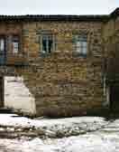
38 38 Dimër në rrugicat e Korçës Winter on the Korca roads


39 Rrugicë në zonën historike të qytetit Roads in the historical zone of the city Ndërtesa në zonën historike të qytetit, me arkitekturë diverse Buildings in the city s historical zone, with diverse architecture 39


40 Prag krishtlindjesh në Korçë Christmas eve in Korca 40 Ndërtesë me stil arkitektonik rumun Building with the Romaninan architectural style

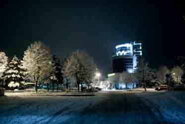
41 Korça natën Korça by night 41


42 Ndërtesë e stilit neoklasik Building with a neoclassic style Banesa e doktor Sotir Polenës, e cila ndodhet në një nga lagjet e vjetra të qytetit, e shquar, veçanërisht, për arkitekturën e saj 42 Banesa e një prej familjeve të pasura tregëtare të qytetit The home of a wealthy businessman in the city


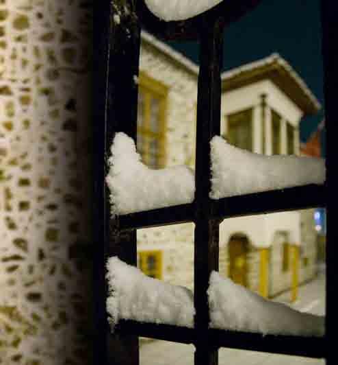
43 Rrugicë me dëborë Roads with snow Banesa në lagjen historike të qytetit Home in the historical area of the city The home of Dr. Sotir Polena, standing in the old section of town, distinguished because of its architecture 43


44 44 Kangjellat karakteristike të shtëpive korçare përgjatë bulevardit Republika Iron work characteristic to the Korca homes along the Republic boulevard


45 Banesa që ndodhen përgjatë bulevardit Republika Homes along the Republic boulevard 45


46 Banesa karakteristike në zonën historike të qytetit Characteristic dwellings in the historical area of the city 46


47 Kopshti i Kishës Ortodokse Kindergarten of the Orthodox Church Shtëpia ku ka jetuar patrioti Mihal Grameno The house used to live the patriot Mihal Grameno 47


48 Godinë karakteristike në sheshin qëndror të qytetit Characteristic buildings in the town center Bulevardi Shën Gjergji Boulevard St. Gjergji 48


49 Ndërtime të viteve 60 Buildings from the 60 s 49


50 Muzg në Korçë Twilight in Korca 50 Lagje në pjesën e sipërme të qytetit Suburb in the higher part of town


51 Mbrëmje dimri në Korçë Snowy evening in Korca Korça e mbuluar nga dëbora Korca covered in snow 51
52 52

53 majtas lart: Silver Center left above: Silver Center majtas poshtë: Fabrika Birra Korçë left below: Factory Korça Beer djathtas: Qendra Tregëtare City Center right: Trade Center City Center 53


54 Lëndina e lotëve Meadow of tears Korça e mbuluar nga dëbora (pamje e marrë nga kodrat e qytetit) 54


55 Pamje nga Lëndina e lotëve View from Meadow of tears Korca covered in snow (view from the hill above the city) 55


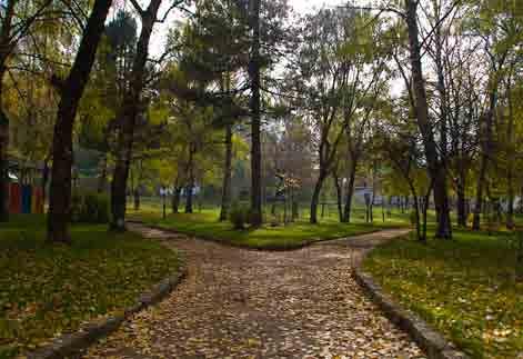
56 56 Rrugicë në parkun Rinia Paths in the Youth park


57 Pamje nga fauna dhe flora në parkun Rinia View from the animals in Youth park Korça 57
58 58


59 Parku Rinia Youth Park 59


60 60 Parku Rinia në dimër Youth park in winter
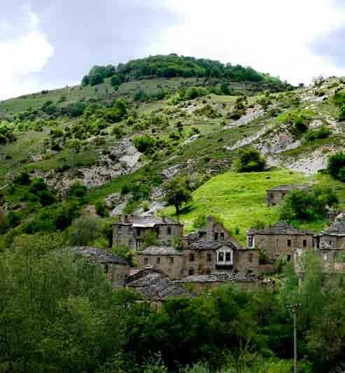
61 61

62 62 Parku Rinia në vjeshtë

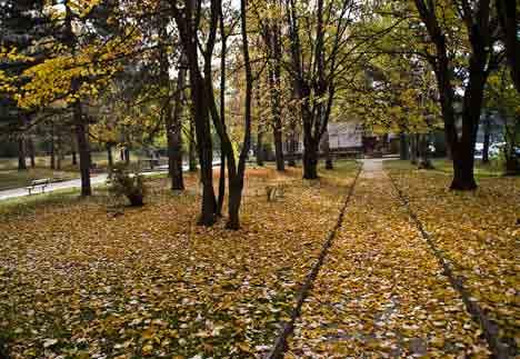
63 Youth park in autum 63

64 64 Pazari i Korçës (pamje nga lart)
")
65 Korça Marketplace (view from above) 65


66 66 Qendra e re tregëtare në Pazarin e Korçës The new trade center to the Marketplace of Korça


67 Tregu ushqimor në Pazarin e Korçës Food trade at the Korça Marketplace 67

68 68 Korça (pamje nga lart)
")
69 Korça (view from above) 69
70 VOSKOPOJA Voskopoja është një vendbanim mesjetar i hershëm, i cili daton që prej vitit Ajo ndodhet 21km larg qytetit të Korçës, e shtrirë mbi një pllajë 1160m mbi nivelin e detit. Nga Manastiri i Shën Prodhromit, hapet para vizitorëve një pamje e mahnitshme, prej nga duken majat e Lenjës dhe Ostrovicës, me një lartësi prej 2246m. Lulëzimin më të madh Voskopoja e ka patur në vitin 1764, atëherë kur popullsia e saj arriti në 30,000 banorë. Në këtë periudhë, ajo kishte 25 kisha (me afreske të veçanta), prej të cilave kanë mbetur vetëm shtatë. Në të njëjtën periudhë, në këtë qytetërim, është ngritur Akademia, Biblioteka dhe Shtypshkronja. Koha e themelimit të Voskopojës rezulton në vitin 1330, sipas arkivave të gjetura në Manastirin e Shën Prodhromit. Legjendat mbi themelimin e qytetit janë të ndryshme, por nuk ka ende të dhëna të sakta. Voskopoja kishte artizanat të zhvilluar dhe kjo, shërbeu si urë lidhëse, jo vetëm brenda vendit, por edhe jashtë tij. Shkatërrimi i parë i saj ndodhi në vitin 1769, i dyti në vitin 1789 dhe i treti në vitin Kavalioti i përshkruan katastrofat e viteve 1769, 1789, si katastrofa ku u rrëmbyen vlera të panumurta kulturore dhe artistike, të cilat humbën për të mos u rikthyer më. Zhvillimi në Voskopojë i profesioneve dhe zejeve të kohës, u bë një nxitës real i konkurencës në të gjithë Ballkanin, duke dhënë shënjat e para të një kulture paraindustriale, që do të sillte, padyshim, një zhvillim parakapitalist, të domosdoshëm për zhvillimin e rajonit. Mallrat që prodhoheshin në Voskopojë kanë qënë të famshme dhe ndonjëherë, për t u dalluar, mbanin të gdhendur një stemë me shqiponjë (siç ndodhte me sëndukët). Lidhjet tregëtare me Laipcigun, Vjenën, Budapestin, Bullagrinë, Kostandinopojën, ku voskopojarët themeluan shtëpitë tregëtare, ndihmuan zhvillimin e tregëtisë, industrisë dhe shtimin e mirëqënies së qytetit. Pronarët e këtyre shtëpive tregëtare, ishin njerëz të kulturuar dhe të pasur, që ishin vendosur prej kohësh në disa qendra europiane. Sipas Aurel Plasarit: Në qytet kishte 14 koorporata. Mund të themi pa e zmadhuar se, historia e qytetit është historia e koorporatave të tij. Këto 14 koorporata përfaqësonin kategoritë e mëdha industriale dhe tregëtare. Elementi më i çuditshëm i Voskopojës është standarti demokratik i administrimit të saj. Ajo drejtohej nga borgjezia tregëtare dhe zejtare, në mënyrë të pavarur nga Porta e Lartë, nëpërmjet parimit të votimit. Voskopoja ishte një qytet autonom brenda Perandorisë Otomane, i përbërë kryesisht nga popullsia vllahe dhe pakica greke dhe shqiptare. Analiza të vitit 1935, bazuar në eponimitë e familjeve voskopojare, tregojnë se pjesa më e madhe e popullsisë ishte vllahe. Akademi e Re, Biblioteka dhe e vetmja Shtypshkronjë e Perandorisë së asaj kohe, ka qënë një trekëndësh kulturor unikal në Ballkan, në mesin e shekullit të XIX. Për aq kohë sa Voskopoja lulëzoi, një numur shumë i madh të rinjsh u shkolluan dhe u formuan me një identitet europian, të mbrujtur me idetë iluministe. Arti dhe kultura në Voskopojë patën një zhvillim të paparashikuar duke e kthyer Shqipërinë në një far që ndriçonte gjithë Ballkanin otoman. Nga të dhënat e copëzuara që vijnë sot, rezulton se, Voskopoja po përjetonte për të parën herë krijimin e një gjuhe të shkruar shqipe. Teodor Kavalioti ishte ai që kishte krijuar një alfabet, gërmat e të cilit mund të identifikoheshin si analoge me ato të glagolitishtes ilire. Ky alfabet, që është zhdukur në rrënojat e Voskopojës, u kurorëzua me aktin më të rëndësishëm të kohës, përkthimin e së parës Dhjatë të Re, nga gjuha greke në gjuhën shqipe. Gjithashtu, ndër dijetarët që u morën me shqipërimin e dhjatave përmendim Grigor Voskopojarin (zv./rektori i Akademisë së Re), si dhe Dhaskal Todrin, i cili përdori një alfabet origjinal që e shpiku vetë dhe që u përhap edhe në Elbasan. Kështu, Voskopoja e asaj kohe ishte kthyer në një qendër të lëvrimit të shqipes dhe pak nga pak, ajo po bëhej një fanar ndriçues dhe orientues drejt pavarësisë shqiptare. Voskopoja zgjon interes të jashtëzakonshëm me kishat e mbijetuara, këto janë: Manastiri i shën Prodhromit, Kisha e shën Kollit, Kisha e shën Thanasit, Kisha e shën Mëhillit, Kisha e shën Marisë, Kisha e profetit Ilia dhe Kisha e shën e Premtes. Këto objekte fetare, janë pjesë shumë e rëndësishme e trashëgimisë kulturore, sepse përfaqësojnë vlera të çmuara të besimit, historisë dhe qytetërimit. Në vitin 2002, këto objekte kulti janë renditur në Fondin e 100 Monumenteve Botërore në rrezik rrënimi. Në sfondin e artit ikonografik të Voskopojës, më i shquari është Davidi nga Selenica, i cili ka pikturuar në vitin 1721 kishën e shën Kollit. David Selenica ka qënë artisti më me influencë i Rilindjes së gjithë artit ballkanik dhe ndikimi i tij u ndje në të gjithë artin ortodoks të Ballkanit, sepse ai dha shënjat e para të kapërcimit të klisheve të pikturës zyrtare të Malit Athos. 70
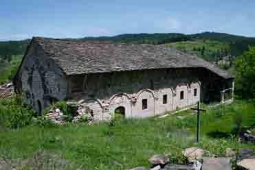
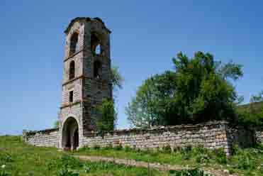
71 VOSKOPOJA As discovered in the archives at the Monastery of Saint Prodhromi, Voskopoja is a medieval town dating from 1330 A.D. It lies on a high plateau at 1160 meter level about 21km from Korça. When leaving the Monastery of Saint Prodromous, a magnificent view awaits at the top of the Ostrovicë Mountain Range (elevation 2246m). Until 1764, Voskopja was a flourishing city with 30,000 inhabitants. At that time it had 25 churches with beautiful frescos. Today only seven of these remain. In the same period, the Academia, Library and publishing house were built. Various legends exist about the city s origin; however, the exact story is unknown. Voskopja s advanced craftsmanship served as a major bridge of connection throughout the country as well as into the neighboring countries. However, Voskopja was destroyed first in 1769 and once again in The third time was in Kavalioti describes the catastrophes of 1769 and 1789 as priceless losses of culture and invaluable art that could never be replaced. The development of professions and arts in Voskopja stimulated excellent craftsmen s competition throughout all of the Balkans. This created the first signs of an industrial culture that brought about without a doubt an early capitalism, which was needed for progress of the region. The arts and crafts produced in Voskopja are very famous and often distinguished by a carved logo of an eagle. The city s trade extended far to Leipzig, Vienna, Budapest, Sofia, and Constantinople. In these places, people from Voskopja also established trading companies, promoted progress in commerce and industry which added to the quality of these cities. These owners of commerce were wealthy, cultured people, who took their place among some European centers. According to Aurel Plasarit, the city (Voskopja) had fourteen cooperatives. One may say without exaggeration, that city s history is the history of cooperatives (the ideal of trade unions). Each represented large industries and trades. The most surprising detail about Voskopja was her democratic standard used in civil government. The city was led independently from the Ottoman Porte by elected bourgeoisie from the business and trade sectors. Voskopja enjoyed a special status as an autonomous city within the Ottoman Empire. The majority populations of the city were Walachians and Greeks with an Albanian minority. In the 1935 census of Voskopoja, the majority population was Vllah or Walachian. The new Academy, the library and the only printing house of the Empire during that time formed a unique cultural triangle in the Balkans in the middle of the 19 th Century. During Voskopja s most flourishing days, a great number of youth were educated and cultivated a European identity filled with enlightened ideas. Voskopoja s culture and art had a surprising influence which made Albania a beacon that enlightened the whole Ottoman Balkan Peninsula. From various bits of gathered information today, it appears that Voskopja may have been the first to enjoy the written form of the Albanian language. Teodor Kavalioti created an alphabet with letters that may be identified as similar to those of Illyrian glagolitish. This alphabet which disappeared in the ruins of Voskopja was crowned by the most important accomplishment of that time, the first translation of the New Testament from Greek into Albanian. Grigor Voskoporjarin, a Vice-Chancellor of the new Academy, and Dhraskal Todrin were among the scholars who worked on translations of the Testaments. Todrin created an original alphabet later used in Elbasan. From this period, Vosokopja became a center for cultivation of the Albanian language. Over time, the city became a beacon that helped lead the way towards nationalism and Albanian independence. The picturesque relic churches of Voskopja are of extraordinary interest for visitors; particularly those of Saint Nicolas, Saint Athanasios, Saint Michael, Saint Mary, Saint Friday (Paraskevi) and the Prophet Ilia as well as the Monastery of Saint Prodromus. These religious objects represent a great part of Albanian cultural inheritance through their distinguished past religious, historical and cultural values. In 2002, these objects were listed among the 100 World Monuments at Risk. David from Selenica is the most famous iconographic artist of Voskopja. Of special acclaim are his paintings in the Church of Saint Nicolas Church in In Balkan art, David Selenica was the most influential Balkan artist during the Renaissance era. His technique impacted all Balkan Orthodox art by being the first artist to move beyond the official art style of Mount Athos. 71


72 Emblema e Voskopojës Emblem of Voskopja Kisha e shën e Premtes, St. Paraskevi Church 72

73 Fshati Voskopojë Voskopoja village 73


74 Shën Prodhromi është një nga manastiret më të njohur dhe më të vjetër të Shqipërisë. Ai daton në shekullin XIV dhe nga të dhënat rezulton se kishte kodik që në vitin Pranë manastirit ndodhen edhe fjetoret, të cilat janë restauruar gjatë viteve të fundit. Shën Prodhromi është një nga vendet më të preferuara për pushime malore, me klimë të mrekullueshme dhe gjelbërim të dendur në hapësirën përreth. Manastiri, për shkak të vlerave historike dhe ikonografike që mbart, është shpallur monument kulture dhe restaurimi i tij do të kryhet nën kujdesin e UNESCO. Manastiri i Shën Prodhromit Manastery of Saint Prodromus The Monastery of Saint Prodromus is one of the most famous as well as the oldest found in Albania dating from the 14 th Century. Ecclesiastical documents go back as far as 1330 A.D. The Monastery became a cultural monument due to her great historical value and her priceless icons. UNESCO is over the restoration project of this monument. The mountainous region of Saint Prodromus is a favorite holiday spot with its excellent climate, dense forest and scenery. Located near the Monastery, is a recently remodeled hotel. 74


75 Pylli i shën Prodhromit Saint Prodromus forest Fjetoret e Manastirit të shën Prodhromit Dormitory of the Monastery of saint Prodhromit 75


76 Kisha e shën Kollit Objekt kulti 300-vjeçar Saint Nicolas Church, 300 year old religious object 76
77 Kisha e Virgjëreshës Mari (1741) The Church of Virgin Mary (1741) 77


78 Kisha e shën Thanasit Church of St. Athanasios Kisha e Shën Thanasit, e cila shquhet për afresket e rralla, është një nga 24 kishat e Voskpojës, që u ka mbijetuar shkatërrimeve gjatë shekujve. Kisha, e cila është Monumenet Kulture i kategorisë së parë, daton në vitin 1724 dhe është ndërtuar prej pesë mjeshtrash të njohur nga Kosturi, ndërsa pikturat murale të saj, në pjesën më të madhe të tyre, janë vepër e vëllezërve Shpataraku. The rare frescos in the Church of Saint Athanasios, one of Voskopja s notable twenty four churches, wonderfully survived decay through the ages. The church is a first class cultural monument from 1724 A.D. Five well-known master masons from Kastoria (today in Northwestern Greece) built the church. The Shpatarak brothers painted the majority of the church s murals. Pamje nga afresket e Kishës së shën Thanasit View of the fresco in the St. Athanasios Church 78


79 lart: Ura e shën e Premtes above: St. Paraskevi bridge poshtë: Ura e Kovaçit down: Blacksmith bridge 79


80 Ndërtesë e re prej guri, sipas traditës së ndërtimit të shtëpive të vjetra voskopojare Stone building, according to the old building traditions of Voskopja Pamje e pjesshme nga kompleksi turistik Akademia Partial view of the tourist complex Akademia 80

81 Kompleksi turistik Akademia Tourist complex Akademia 81


. The other villages of Voskopoja, Gjyras, Damjanec and Krushova surround her.")
82 Fshati Shipskë shtrihet në skajin e sipërm të zonës së Voskopojës, 4km larg qendrës së komunës me të njëjtin emër, në lartësinë 1270m mbi nivelin e detit, e kufizuar me fshatrat Voskopojë, Gjyras, Damjanec dhe Krushovë. Shipska dallohet për natyrën e virgjër dhe klimën e shëndetshme malore. Për të shkuar në këtë fshat duhet të kalosh përgjatë një rruge, e cila ndahet në dy pjesë, prej një urë me qemer prej guri, e ndërtuar disa shekuj më parë. Poshtë saj gurgullojnë ujërat, që burojnë nga lartësitë e thepisura të kësaj zone. Në hyrje të fshatit ngrihet kisha e shën Gjergjit (shek. XVII) dhe më tej shfaqen shtëpitë e ndërtuara me gurë shtufi, shumë prej të cilave sot janë të braktisura. The village of Shipska lies four kilometers from the city center of Voskopoja at the top of the summit (1270m). The other villages of Voskopoja, Gjyras, Damjanec and Krushova surround her. The area is acclaimed for its splendid untouched nature and healthy mountain climate. To reach Shipska, follow the road divided into two parts by a stone arched bridge from a few centuries ago. Beneath it, gurgles fresh mountain water flowing from the heights of the rocky hilltop. The 17 th century Saint George Church sits at the village entrance. Walking further, one encounters homes built with volcanic stone. Many of these are abandoned today. Ura e Shipskës Shipska bridge lart: Rrugicë dhe banesë karakteristike e Shipskës above: Narrow street and characteristic home in Shipskë 82 majtas: Çezmat e vjetra të fshatit left: Old village well


 83")
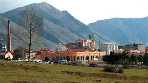
83 Kisha e Shën Gjergjit, restauruar nën kujdesin e europarlamentarit, z.ioannis Averoff (Shipskë) Saint Gjergji Church, restored by the donation of eurodeputy, mr.ioannis Averoff (Shipskë) 83

84 Vithkuqi është një prej tre fshatrave malorë të rrethit të Korçës, i cili tërheq një numur të madh vizitorësh, krahas Voskopojës dhe Dardhës malore. Fshati ndodhet 27km larg qytetit të Korçës dhe është i vendosur midis maleve. Pika e tij më të lartë, 1750m mbi nivelin e detit, quhet Rungaja. Terreni i thyer kodrinor i fshatit Vihtkuq, që shtrihet në tre lagje të mëdha, shpalos bukuritë dhe vlerat e një natyre të mrekullueshme malore. Në shek.xviii, në periudhen e lulëzimit te tij, Vithkuqi ka patur 24 kisha, prej të cilave sot rruhen vetëm 4, në gjendje të mirë dhe të restauruara, që përfaqësojnë vlera te mëdha historike të artit bizantin. Përmendim ndër to, kishën e shën Pjetrit, të pikturuar nga vëllezërit Zografi, së bashku me varrezat e lashta përbri, si dhe kishën e shën Mëhillit, e cila ka afreske në dy shtresa dhe mendohet se është pikturuar nga Kostandin Jeromonaku. Vithkuqi është vendlindja e Naum Panajot Bredhit ( ), ideologut të Rilindjes Kombëtare, hartuesit të Evetarit (1844), abetares së parë shqipe, me 33 shkronja. The village of Vithkuq is one of three mountain villages in the Korça district which attracts a great number of visitors along with Voskopja and Dardha. The village lies only 27 km from the city of Korça surrounded by mountains. Rungaja at 1750m is the highest peak. The hilly terrain of Vithkuq stretches over three magnificent areas manifesting the splendid natural mountainous beauty. The village flourished during the 18 th century. Today only four of her original twenty-four churches are restored and remain in good condition. They hold great historical value for Byzantine art. Of worthy mention is the Church of Saint Peter, painted by the brothers Zografi, along with its cemetery. Also noteworthy, is the Church of Michael with its frescos of two layers believed to the work of Kostandin Jeromonaku. Vithkuq is also the birthplace of Naum Panajot Bredhi ( ), ideologist of the Albanian Renaissance and compiler of Evetarit (1844), the first spelling book in Albania with 33 letters. Vithkuq (pamje nga lart) Vithkuq (view from above) 84


85 djathtas: Varri i Pagëzimit right: Baptism grave Kisha e kryeëngjëllit Mihail The Church of arcangel Michael 85


86 Kisha e shën Pjetrit St. Peter Church Kisha e shën Damianit & shën Kozmait St. Damian & St. Kozma Church Kisha e shën Pjetrit The Church of St. Peter 86


87 Këmbana e kishës së shën Pjetrit St. Peter church bell poshtë: Rezervuari i Gjançit down: Gjançi reservoir Plevicat karakteristike të fshatit Characteristic stalls of the villagel 87

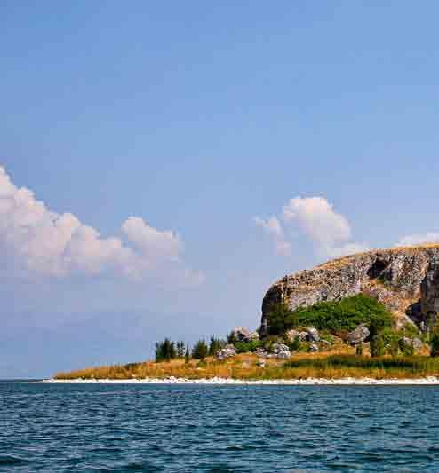
88 Pamje piktoreske nga zona e mbrojtur Natura 2000, liqeni i Prespës së Madhe Prespa ose Liqeni i Prespës, është një liqen me ujëra të freskëta, i cili u takon tre shteteve; FYROM-it, Shqipërisë dhe Greqisë, me një sipërfaqe të përgjithshme 313.6km 2, nga të cilat 38.8km² i takojnë Shqipërisë. Prespa është liqeni më i thellë tektonik në Ballkan, me një thellësi prej 853m dhe ndahet në dy pjesë të quajtura Prespa e Madhe dhe Prespa e Vogël. Në liqen derdhen disa përrenj të vegjël, ndërsa ai vetë nuk ka rrjedhje sipërfaqësore. Liqeni rrethohet me male të larta, me një lartësi prej 2000m dhe me një sipërfaqe prej 3136km 2. Përsa i përket madhësisë, ai llogaritet menjëherë pas liqenit të Shkodrës dhe atij të Ohrit. Liqeni i Prespës, është një nga zonat më tërheqëse turistike të Ballkanit, e cila përveç bukurive të jashtëzakonshme natyrore, shquhet për florën dhe faunën e pasur. Në të gjenden rreth 1500 lloje bimësh, më shumë se 40 lloje gjitarësh, 261 lloje zogjsh dhe 23 lloje peshqish. Në Prespë jeton edhe pelikani dalmat, me përqëndrim kryesor në Prespën e Vogël, si dhe shtatë lloje çafkash. Në Prespë ndodhen gjithashtu edhe 30 monumente të kulturës bizantine, si dhe një numur mjaft i madh veprash antikiteti. 88

89 Greater Prespa lake, picturesque view of the procted area Nature 2000 Prespa or Lake Prespa is a fresh body of water bordered by three countries; Albania, the Former Yugoslavian Republic of Macedonia and Greece. The surface area of the lake is 313.6km 2 of which 38. 8km 2 lie within Albania. Prespa is the deepest tectonic lake in the Balkans with a depth of 853m. It is divided into two lakes: Large Prespa and Small Prespa. Though small springs empty into the lake, there are no significant rivers feeding into them. High mountains reaching 2000m and covering a surface area of 3136 km 2 surround Lake Prespa. In terms of the circumference, Prespa is the third largest lake in Albania after Lake Shkodra and Lake Ohrit. Prespa is one of the most desired tourist spot in the Balkans due to her extraordinary natural beauty coupled with her rich fauna and flora. The area contains 1500 different types of plants, 261 varieties of birds, more than forty different sorts of mammals and twenty-three kinds of fish. In the region, Dalmatian pelican and seven varieties of seagulls have their habitat at the Small Prespa Lake. Prespa is also home to thirty Byzantine cultural monuments as well as a large number of ancient ruins. 89

90 Kisha e shën Marisë, në ishullin e Maligradit, shtrihet në anën perëndimore të tij, nën kulmin e një shpelle të madhe, me përmasa 4,60m x 3,30m. Kisha paraqet veçanti me ciklet ikonografike dhe mbishkrimet historike, të viteve 1345 dhe Pikturat e Maligradit i takojnë stilit të ri ikonografik të quajtur stili paleolog, një rilindje artistike kjo e ikonografisë bizantine. Pikturat janë vizatime antropomorfe, me një stil ekspresiv primitiv, të cilat janë vendosur në mënyrë të çrregullt. Duket qartë, që kjo faqe shkëmbore ka qenë e shenjtëruar, si një tempull i hapur në natyrë dhe më vonë, pranë tij, u ngrit kisha e Shën Marisë. Kisha e shën Marisë, brenda shpellës, në ishullin e Maligradit. St. Mary Church, inside rock on the Malgradi island 90


91 Afresku i shën Marisë Fresco of St. Mary The Church of Saint Mary, built beneath the top a large grotto of 4.60 by 3.30 meters, lies on the western side of the Island of Maligrad. The Church is cherished for her icons and historical writings from the years 1345 and The Paleolithic style used in Maligrad paintings is a newer renaissance form of Byzantine icons. The pictures of anthropomorphous drawings express an irregular, primitive style. Apparently this rock cliff was a blessed natural temple where later Saint Maria s Church was erected. 91
92 92

93 Ishulli i Maligradit Island of Maligradi 93


94 Liqeni i Prespës së Madhe, pamje piktoreske Greater Prespa lake, picturesque view Pamje nga liqeni i Prespës View of the Prespa lake 94


95 Liqeni i Prespës së Vogël, natyrë e qetë Nature around the lesser Prespa Lake Liqeni i Prespës së Vogël, kallamishtet dhe rrjetat e peshkimit Lesser Prespa Lake, stubbles and fishing nets 95


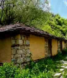
96 DARDHA Dardha është një fshat turistik, që ndodhet 20km në juglindje të Korçës, në një lartësi prej 1334m mbi nivelin e detit. Prej kohësh, fshati i Dardhës bën pjesë në listën e gjatë të destinacioneve turistike të Shqipërisë. Emri Dardhë vjen nga një legjendë, sipas së cilës thuhet se të ikurit qëndronin në një fushë, rreth një pemë dardhe dhe atë e quanin si fusha poshtë dardhës. Dardharët njiheshin si druvarë të mirë, profesion ky nga më të përhapurit në atë kohë. Studimi arkitektonik i fshatit dëshmon prezencën e një stili europian, i cili ndeshet dhe në shumë fshatra të tjerë të Shqipërisë lindore. Pamja që krijonin banesat, urbanistika e fshatit, ndërtimet e forta me gurë të skalitur, rrugicat me kalldrëm, burimet e shumta, punishtet e artizanëve të shumtë, si dhe dyqanet, i jepnin Dardhës imazhin e një qyteti të vogël në rritje, pavarësisht se popullsia e saj zvogëlohej për shkak të emigracionit në masë. Disa prej shtëpive sot duken të braktisura, ose të lëna pas dore, por shumë banorë po kthehen dhe po i rindërtojnë banesat e vjetra. Tashmë janë rikonstruktuar rreth 40 shtëpi, të cilat kanë për synim zhvillimin e turizmit familjar. Shumica e vizitorëve që vijnë në Dardhë pushojnë në një lëndinë në të cilën është krijuar një kamping i vogël, ndërsa të tjerë preferojnë hapësirën në pyll, për intimitet dhe qetësi. I vështirë në dimër, por i bukur në verë, ky fshat është bërë shumë i vizitueshëm. Të panumurta janë burimet me ujë të akullt, midis të cilëve veçohet burimi Uji i Qelbur, që konsiderohet si kurativ. Specialiteti kulinar i këtij fshati është lakrori (një lloj byreku me dy petë, i pjekur në saç) dhe rakia e kumbullës së egër, produkte këto që të ofrojnë në Dardhë, atje ku mikpritja ndjehet sapo shkel në pragun e një porte. Dardha preferohet, sidomos, në dimër nga skiatorët, sepse në këtë zonë dëbora shkrin vonë. 96


97 DARDHA Dardha is a scenic village about 20 km southeast of Korça at 1334 meters above sea level. For years, the village of Dardha has enjoyed her status among the many popular tourist destinations in Albania. Her name, Dardha or pear in English, is derived from a legend which believes that dead people gather in a field around a pear tree. So it is called, the field below the pear. The Dardha people were known as excellent woodworkers; a profession widely propagated at that time. Her architecture testifies of a European presence and style. The same structural design is found among many villages in Eastern Albania. As an effect of the homes, town design, strong stone cut buildings, cobblestone roads, many spring waters, artisan workshops and stores, Dardha had an atmosphere of a small developing city. This appearance occurred independent of her dwindling, small population as a result of mass immigration. Today many houses appear abandoned and in disrepair. However, many people are returning and rebuilding their old homes. Most that come to Dardha relax in a meadow where a small camp ground is provided. Others enjoy the quiet of the open forest. The area is magnificent in the summer and receives many visitors. Though it is difficult to visit in the winter due to the cold, skiers love it because the snows melt late in the season. The region has innumerable refreshing, icy springs. A favorite one is called black water for its healing properties. The culinary specialties of the village are lakror, a type of two layered cheese pie baked in a special open air oven with charcoal on the top and bottom, and a wild plum brandy called raki. Dardha s amazing hospitality is felt the moment one steps on a doorstep. Today there are around forty rebuilt homes with an aim to encourage tourism for the whole family. 97


98 98 Rrugica karakteristike me kalldrëm, banesa prej guri Characteristic cobblestone roads, home made of stone


99 Pylli i Bozdovecit Bozdoveci Forest Guri i Capit The Goat Rock 99


100 Tuma e Kamenicës Tuma e Kamenicës është një zbulim unikal arkeologjik, dëshmi e qendrës së banuar që në prehistori. Kjo tumë, ka rëndësi jo vetëm pasi është e para në rajon, por edhe për pasurinë arkeologjike, që u ofron vizitorëve. Hapësira ku ngrihen strukturat e varreve është 3m nën nivelin e tokës. Varrezat janë në formë rrethore, në qendër të të cilave ndodhet varri qëndror. Pjesë e kësaj qëndre është edhe dhoma muze, ku janë vendosur stendat dhe ku paraqitet kronologjia e tumës, më të dhëna arkeologjike, antropologjike, historike dhe kulturore. Brenda kësaj dhome gjendet edhe një platfomë e kodërvarrit, si dhe skelete, orendi të ndryshme zbukurimi, etj. Në një sipërfaqe prej 6500m 2, krahas strukturës monumentale të kodërvarreve dhe dhomës muze, ka edhe mjedise çlodhëse dhe ambiente të gjelbëruara. Në hyrje të tumës është ngritur një urë, e cila ka si element gurin, ndërsa dhoma muze është e ndërtuar me dru. Tuma e Kamenicës daton në shek 12-6 p.e.r. Varri i hershëm qendror, e ka zanafillën në bronzin e vonë dhe më pas vazhdimësia në këtë kodërvarr rrjedh për gati 6 shekuj, deri në fillim të epokës së hekurit, gjë që tregon për ekzistencën e një vendbanimi të hershëm prehistorik. Për herë të parë, tuma është zbuluar rastësisht në fillim të viteve 60, të shekullit të kaluar, ndërsa fshatarët e kësaj zone punonin tokat e kooperativës, por zbulime të mirëfillta arkeologjike, u kryen në vitet Gjatë gërmimeve arkeologjike u zbuluan 440 varre me mbi 300 skelete. Nga studimet rezultoi se, pjesa më e madhe ishin meshkuj dhe më pak femra. Në një varr u zbulua skeleti i një nëne shtatzanë, me një fëmijë disa muajsh në bark. Njëhërësh janë zbuluar edhe 3500 objekte arkeologjike si: heshta, sfurqe, orendi zbukurimi grash dhe objekte të ndryshme qeramike. Ky muze natyror, i shndërruar në një kompleks të vizitueshëm, përfaqëson një pikë të re të trashëgimisë kulturore historike, jo vetëm për rajonin e Korçës, por për gjithë Shqipërinë. 100


101 Tomb of Kamenica The tombs excavated in Kamenica are truly an extraordinary archeological find which bears witness to the prehistoric life in Albania. As the first of its kind in the area, the tomb merits great significance along with its tremendous archeological treasures on exposition for visitors. The open area around the tombs was discovered three meters underground. The graves were laid out in a circular fashion with the primary burial site placed in the center. Today a section of this hosts an outstanding museum displaying various burial artifacts. A chronology of the tombs with archeological, anthropological, historical and cultural information is well exhibited. A platform mound is found inside the museum in order to examine a skeleton, furniture and various decorations taken from the burial spot. On the graveyard and museum grounds which cover an area of 6500 square meters, visitors enjoy the green environment in the provided rest area. The vicinity is entered by crossing a stone bridge which leads to the wooden museum building. The Tombs of Kamenica date back to the 12 th until the 6th centuries before Christ. The oldest tomb, which is located in the center, dates from the Late Bronze Age. The mound continued to be used for another six centuries up to the dawn of the Iron Age. All of these findings establish the fact of an early prehistoric age. Originally the tombs were discovered by accident as villagers worked in the cooperative fields in the 1960 s. Actual archeological excavation took place in 2000 through 2002 of this century. During the digs, 440 graves with over 300 skeletons were unearthed. Upon examination, it was found that the majority of the skeletons were men and fewer were women. A skeleton of a pregnant mother with her fetus in her abdomen rested intact in one of the graves. All together 3,500 archeological artifacts such as furniture, women s beauty implements, spears, and other ceramic objects were attained. This natural museum, which is an immense, new inheritance not only for Korça but for all of Albania due to its great cultural and historic significance, has been transformed into a grand Visitor Center. 101
.")
102 Pesë kilometra larg Korçës, në juglindje të saj, ndërmjet dy lumenjve të vegjël, në rrugën që të çon për në Kolonjë, gjendet Drenova, e cila qëndron në rëzë të Malit të Moravës dhe në ballë të Fushës së Korçës, një pozitë kjo, e përshtatshme dhe interesante gjeografike. Drenova është vendlindja e poetit të njohur shqiptar Aleks Stravre Drenova (Asdreni). Drenova lies five kilometers southeast of Korça between two little streams on the road to Kolonja. The village rests at the base of the Mountain Morova at the beginning of the Korça valley in an interesting and desirable geographical location. Drenova is the birthplace of the well known Albanian poet Aleks Travre Drenova (Asdreni). Fshati Mborje & fshati Drenovë (pamje nga lart) Villages of Mborje and Drenove (view from above) 102


103 Kisha e Ristozit, ndodhet në krye të fshatit Mborje, në Korçë. Ajo është një nga objektet më të hershme të kultit në Ballkan. Afresket e saj janë realizuar nga piktorë anonimë, në vitin Ky vend i shenjtë, vizitohet nga qindëra besimtarë, 40 ditë pas Pashkës së Madhe. Kisha e vjetër e Ristozit / lart: pamje ballore The old church of Ristozi / above: front view The Ristoz Church sits at the top end of the village of Mborja in the district of Korça. The church is one of the earliest religious buildings in the Balkans. An anonymous artist painted its frescos in 1390 A.D. Every year on the fortieth day after Easter, thousands of believers come to visit this holy place. 103

104 104 Këmbanorja e kishës së Ristozit Church Ristozi bell


105 Pamje nga pika turistike e Moravës View from the tourist point on Morave 105

, karakteristik i fshatit Fruit tree (mullberry), characteristic of this village Boboshtica is a picturesque village located ten kilometers outside of Korça.")
106 Boboshtica është një fshat piktoresk, që ndodhet 10km larg Korçës, i cili veçohet për manat e zeza dhe rakinë e famshme, që prodhohet prej tyre, si dhe të qilimave prej leshi, të endura, nga duart e arta të grave vendase. Ky fshat turistik, preferohet veçanërisht prej vizitorëve edhe për tavernat e njohura me gatime tradicionale. Boboshtica ka nxjerrë breza të tërë intelektualësh, që i kanë shërbyer vendit në të gjitha fushat; në art, kulturë, arsim, etj. Ndër më të shquarit prej tyre përmendim Viktor Eftimiun. Dru frutor (mana), karakteristik i fshatit Fruit tree (mullberry), characteristic of this village Boboshtica is a picturesque village located ten kilometers outside of Korça. She is known for her mulberries and famous berry raki (brandy), as well as, the beautifully hand woven wool carpets artistically done by local women. Sightseers often choose to visit this tourist place for its excellent traditional cuisine. Boboshtica has produced many generations of intellectuals that served their country in every field including the arts, culture and education. One of the most distinguished ones was Viktor Eftimiu. 106 Kisha e anargjëndëve Kozma & Damiano fshati Dishnicë The church of St. Kozma & St. Damiano, Dishnica village


107 Kaminat e qymyrit të drurit, Lozhan Coalwood mine, Lozhan Pamje nga sipër e tre urave, Lozhan View from above ot the three bridges, Lozhan 107


108 108 Pallati i Kulturës në Maliq Palace of culture in Maliq town
")


109 Libonik (pamje nga lart) Libonik (view from above) Shkolla 9-vjeçare në Maliq Elementary School in Maliq Pamje nga lart e qytetit të Maliqit View from above of Maliq 109
110 110 Mali i Thatë dhe Mali Ivan

111 The Dry Mountain and Mountain Ivan 111


112 Pamje nga fusha e Zëmblakut Aspekte nga punët në bujqësi në fshatin Pojan Aspects from village work in Pojan village Jeta bujqësore në fshatin Rëmbec Agriculture life in Rëmbec village Sipërfaqe e mbjellë toke bujqësore 112


113 View of the Zëmblaku fields Jeta rurale në fshatin Pëndavinj Rural life in Pëndavinj village Planting in the fields Punët në bujqësi në fshatin Pëndavinj Agriculture works, Pëndavinj village 113
114 114
115 115
 Festa e Karnavaleve në fshatin Polenë Feast of carnival in Polena")
116 Rruga nacionale Korçë - Ersekë (garë çiklizmi) National Road Korçë - Ersekë (cycling race) Festa e Karnavaleve në fshatin Polenë Feast of carnival in Polena Village 116
117 BILISHTI Qyteti i Bilishtit ndodhet në juglindje të Shqipërisë dhe në lindje të fushëgropës së Devollit, i vendosur në këmbët e Malit të Thatë. Ai kufizohet, në lindje me Greqinë, në veri me fshatin Bitinckë, në perëndim me lumin Devoll dhe në jugperëndim me fshatin Vishocicë. Bilishti ndodhet në lartësinë 930m mbi nivelin e detit dhe ka një sipërfaqe prej 400ha dhe një popullsi prej rreth banorësh, gjithashtu, qyteti është vendosur në një sipërfaqe të pjerrët, që vjen duke u zbutur në drejtim të superstradës nacionale. Bilishti ka klimë paramalore mesdhetare dhe të shëndetshme. Dimri është i ftohtë dhe i lagësht, shpesh me rreshje dëbore, ndërsa vera është e ngrohtë dhe pjesërisht e nxehtë. Kodrat mbi qytet janë të zhveshura, për shkak të formacioneve mbigëlqerore. Në lindje të qytetit, në kuotën më të lartë të tij, ndodhet një rezervuar me kapacietet 1,5 milion m 3 ujë. Qyteti ndahet lehtësisht në gjashtë blloqe banimi, që janë dëshmi e rritjes dhe e zhvillimit të tij. Bërthama e tij ndodhet në lindje, tek Çezma e Madhe dhe është themeluar në vitet , kur u shtrua rruga me kalldrëm, nga qëndra e sotme e qytetit deri tek çezma. Bilishti ka një pozitë gjeografike të përshtatshme, sepse përshkohet nga njëra prej dy superstradave, që lidhin kryeqytetin e Shqipërisë me Greqinë. Dogana e Kapshticës, që ndodhet 7km larg qytetit, është një nga doganat më të rëndësishme në Shqipëri. Bilishti rezulton si qendrër e banuar, prej një harku kohor 3000 vjeçar dhe kjo dëshmohet nga mbeturinat e një kalaje ilire, në një nga kodrat mbi qytet. Pas kalasë, vendbanimi i dytë i hershëm ka qënë Selca, në afërsitë lindore të qytetit të sotëm. Atje janë zbuluar mure dhe themele ndërtesash, si dhe ekzistojnë, gjithashtu, gjurmët dhe legjendat e kishës së shën Kristoforit. Në anën perëndimore të lumit të Devollit janë gjetur gjurmë vendbanimi, që vendasit i quajnë Qypkat dhe Bërzanj dhe mund të kenë shërbyer si pika të tjera, prej nga është bërë zhvendosja e popullsisë drejt Bilishtit. Në fund të shekullit të XIX dhe fillim të shekullit të XX, Bilishti ishte një qendër e rëndësishme zejtare dhe tregëtare. Gjatë ndarjeve të ndryshme administrative, duke përfshirë periudhën , Bilishti ka qënë nënprefekturë, qendër rrethi dhe bashki. Bilishti ka qënë qendër aktive e veprimtarisë kombëtare. Këtu ka punuar patrioti Ali Çaush Vërleni, që u vra për mbrojtjen e tërësisë tokësore të Shqipërisë, ndërsa në vitet , në Bilisht, ka punuar dhe patrioti Themistokli Gërmenji. Qyteti ka gjithashtu tradita të spikatura arsimdashëse. Shkolla e parë fillore është çelur në vitin 1917, në një dhomë të teqesë, në bllokun e Çezmës së Madhe, ndërsa në vitin 1933 u ngrit godina e re e shkollës tek vendi i quajtur Kalinçja. Bilishti është nga të paktat qytete periferike të Shqipërisë, me popullsi të dyfishuar gjatë viteve të tranzicionit. Për disa vite Bilishti shërbeu edhe si qendër rrethi më vete. Vitet e fundit është përmirësuar dukshëm infrastruktura dhe është rritur ndjeshëm niveli i jetesës. Shëtitorja Fuat Babani, e mbuluar nga degët e gështenjave të egra, është një nga rrugët më të bukura në Shqipëri. Shumë vizitorë, që e kanë parë për herë të parë Bilishtin, e kanë krahasuar atë me një lagje të Tiranës. BILISHT The city of Bilisht stands in the lower plains of Devoll County at the base of Dry Mountain in the southeastern part of Albania. The city is located near the northeastern border of Greece and is surrounded by the village of Bitincka on the north, the Devoll River on the west, and the village of Vishocia to the southwest. The elevation of Bilisht is 930 meters above sea level and covers an area of 400 hectares. The population is approximately inhabitants. The city is built downwards on the sloping foothills to the flat surface of the national highway. Bilisht has a healthy Mediterranean climate. The winters are cold, wet and often snowy, whereas, the summers are warm and at times very hot. Since the hills above the city are filled with limestone, they are barren. At the highest southern point of Bilisht, a reservoir lies with a water capacity of 1.5 million m 3. The city s growth and development are evident by how she spreads out over six large neighborhoods. On the eastern side a large water fountain, known as Çezma e Madhe, was erected during the last century between 1914 and 1918, while the cobblestone roads were paved from the well into the center of the city. The excellent geographical location of Bilisht connects the capital of Albania with Greece by two highways. The Custom s House of Kapshtica is seven kilometers from Bilisht. This is one of Albania s most important border crossings. Around 3000 years ago, people inhabited Bilisht as verified by the ancient arch from that era. Ruins of an Illyrian castle stand on one of the hills above the city. Following this period, other early dwellers settled Selca near the southern center of present day Bilisht. Some of the excavated walls and building foundations reveal traces and inscriptions from the Church of Saint Christopher. Just north of the Devoll River are other vestiges of settlements. They are called Qypkat and Berzanj by the local residents. Perhaps, these were another group that finally inhabited Bilisht. By the end of the 19 th and the start of the 20 th Centuries, Bilisht became an important artisan and trade center. During the successive administrative divisions from 1912 through 2009, Bilisht has been at different times a sub-prefecture (nënprefekturë), a district seat (qendër rrethi), and a municipality (bashki). Bilisht has been a center of national activity. The patriot Ali Çaush Vërleni contested for his homeland. He was killed while defending Albania s rights to all of her territory. During 1915 and 1916 A.D., Themistokli Gërmenji, another famous patriot, worked for his nation in Bilisht. The city has a great tradition of promoting education. In 1917, the city s first elementary school was started in a Teqe, a Bektashi holy site, near the Fountain Çezmës së Madhe. In 1933 a new school building was built at Kalinçja. Bilisht is one of the few peripheral cities in Albania. Her population doubled during the years of transition to democracy. For some years, Bilisht served as her own regional center. In the last years, its infrastructure and standard of living have greatly improved. The promenade Boulevard Fuat Babani is covered by the branches from the wild chestnut trees lining the street. It is one of the most beautiful roads in Albania. Many first time visitors compare Bilisht with one of the suburbs of Tirana. 117


118 Pazari i qytetit Marketplace of the town Bulevardi qëndror The main boulevard Qyteti i Bilishtit Bilisht town 118


119 Godinë në sheshin qëndror të qytetit Building in the main square of the town 119


120 Lagje në pjesën e sipërme të qytetit Suburb in the upper area of the city Xhamia e qytetit të Bilishtit Mosque of Bilisht town 120
 Grupi i")

121 Bulevardi qëndror në qytetin e Bilishtit (dimër) Main boulevard in Bilisht town (winter) Grupi i vallëtarëve të Pallatit të Kulturës, Bilisht Dancing group from the Palace of Culture, Bilisht 121


122 122 Shpella e Trenit Cave of Tren
")
")
123 Monument natyre (Tren) Natural monument (Tren) Natyrë malore (Tren) Mauntain nature (Tren) 123
 Castle of")


124 Kalaja e Trojanit (Tren) Castle of Trojan (Tren) 124 Jeta bujqësore në fshatin Bitinckë Agriculture life in Bitincka village

125 QYTEZA Fshati Qytezë u formua në fund të shekullit të XVII, në një nga momentet më të vështira që po kalonte Shqipëria, për të mos u asimiluar si komb nga Perandoria Osmane. Shumë banorë të saj u shpërngulën nga vendlindja e tyre dhe formuan banime provizore, përreth kodrave të fshatit të sotëm. Qyteza e Devollit është shëmbulli tipik i fshatit të vogël shqiptar, i cili rruajti të paprekura, nga brezi në brez, kulturën, gjuhën dhe zakonet. Fshati Qytezë (pamje nga lart) Qyteza village (view from above) QYTEZË The village of Qyteza (which means town in English) was formed at the end of the 17 th Century. This was during one of Albania s most difficult episodes as she strived against assimilation by the Ottoman Empire. Many residents were deported from their homes. They built provisional shelters around the hills of the village. This village located in the District of Devoll is a typical example of one of Albania s small villages. Faithfully, generation after generation seek to keep and protect her culture, language and traditions. 125


126 126 Kisha e shën Thanasit mbi kodrën e varrezave The church of St. Athanasios on the hill above the graveyard


127 Kisha e Shën Kollit Qytezë The Church of St. Nicolas, Qyteza village Shkolla e parë në Qytezë The first school in Qyteza 127
128 128
")
129 Fshati Sinicë (pamje nga lart) Sinica village (view from above) 129


130 130 Urat e fshatit Sinicë Bridges in the village of Sinice


131 Banesë karakteristike Characteristic dwelling Rrugicë me kalldrëm në fshatin Sinicë Cobblestone roads in Sinice Shtëpi e ndërtuar me mure guri A home built of stone walls Kisha e fshatit Sinicë Church of Sinica village 131

132 132 Banesa karakteristike në Hoçisht Characteristic dwellings in Hoçisht


133 Rrugicë me kalldrëm në Hoçisht Cobblestone roads in Hoçisht 133


134 Kisha e vjetër e shën Kollit The old Church of St. Nikolas lart: Vakëfi i Anargjëndëve Kozma & Damiano, Hoçisht above: Shrine of St. Kozma & St. Damiano, Hoçisht 134
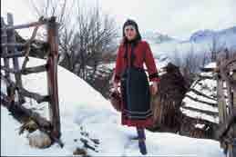
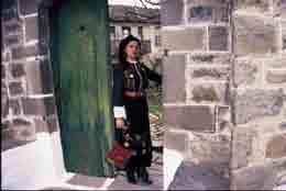
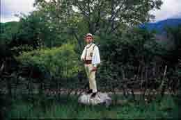
135 Kostume Tradicionale nga Rajoni i Korçës Traditional Costumes from Korça Region 135


136 Kostumi i Vithkuqit Kostumi i Liqenasit Kostumi i Dardhës 136


137 Kostumi i Kolonjës Kostumi i Devollit Kostumi i Rehovës 137


138 Kostumi i Mokrës Kostumi i Rodokalit Kostume të Rehovës 138

139 Kostumi i Mokrës Kostumi i Potkozhanit Kostumi i Linit 139
140 140 KOLONJA Rrethi i Kolonjës është njëri prej 4 rretheve, të Qarkut të Korçës, i cili ka një sipërfaqe prej 805 km 2 dhe një popullsi rreth banorësh. Kolonja shtrihet në pjesën juglindore të Shqiperisë, në një lartësi prej 1100m mbi nivelin e detit. Në lindje të saj ndodhet mali i Gramozit, në perëndim Mali i Radomit, në jug shtrihet malësia e Gërmenjit, kurse në veri, pragu i Qarrit e ndan këtë gropë nga fushëgropa e Korçës. Kjo gropë përshkohet nga një sërë përrenjsh, të cilët mblidhen në pellgun ujëmbledhës të Osumit (lumi i Osumit i kalon tërrthor gropës, në pjesën perëndimore të saj). Gropa e Kolonjës është njësia fiziko-gjeografike më e rëndesishme e kësaj zonë, në të cilën jeton pjesa më e madhe e popullsise së këtij rrethi, me kryeqendër Ersekën. Mali i Gramozit shërben si kufi ndarës i kësaj zone nga territori i shtetit fqinj, Greqisë. Rrëzë këtij mali janë vendosur një sërë fshatrash si: Bezhan, Borovë, Gjonç, Kreshovë, Milec, Rehovë, Skorovot, Starje, Taç, etj., ndërsa në pjesën perëndimore të rrugës nacionale janë vendosur fshatrat: Mesickë, Gostivisht, Qinam, Selenicë, etj. Treva e Kolonjës, qe herët, ka qënë banuar nga fiset ilire të desaretëve. Pozicioni i përshtatshëm strategjik i kësaj treve, ka zgjuar në shekuj lakmitë e shumë pushtuesve, por popullsia e saj u ka rezistuar me trimëri, duke filluar nga rezistenca kundër pushtuesve romakëve, pushtuesve osmanë, deri në shpalljen e Pavarësisë dhe për të arritur më pas, në rezistencën heroike kundër pushtuesve nazifashistë, gjatë Luftës së Dytë Botërore. Kjo trevë ka nxjerrë nga gjiri i saj mjaft ideologë të shquar, publicistë, mësues të talentuar e të përkushtuar, si dhe shumë patriotë që kanë zënë vend nderi në panteonin e historisë sonë kombëtare, si: Fan S. Nolin, Jani Vreton, Shahin Kolonjën, Petro Nini Luarasin, Papa Kristo Negovanin, Gjerasim, Gjergj, Parashqevi dhe Sevasti Qiriazin, Themistokli Gërmenjin e Spiro Ballkamenin, Sali e Gani Butkën, Mersin e Zalo Prodanin, Naum Ceren dhe shumë të tjerë, që iu përkushtuan me mish e me shpirt çështjes kombëtare. Bazuar në zbulimet arkeologjike, gjurmët më të hershme të banimit në këtë trevë i perkasin epokës së neolitit ( vjet p.e.r.). Epoka e Bakrit ( vjet p.e.r.), përfaqësohet nga një daltë bakri dhe një enë e importuar nga Dimini i Thesalisë, e cila është zbuluar në Kamnik. Epoka e Bronzit ( vjet p.e.r.) përfaqësohet nga kultura materiale e zbuluar në vendbanimin e Gurit të Ninës dhe Shkëmbit të Madh, në Luaras dhe sidomos, prej objekteve të zbuluara në varrezat tumulare të Prodanit, Rehovës, Psarit, Shtikës, Borovës, etj. Epoka e Hekurit (mijëvjeçari i parë p.e.r.) përfaqësohet nëpërmjet një sërë fortifikimesh të hapura në Prodan, Pradellë, Borovë dhe sidomos, prej kalave ilire të Hollmit, të Qinamit, Gradecit, Çukës së Borovës, Kalasë së Gradecit (Vrëpckë), Bejkovës, Boshanjit, Qesarakës, etj. Në muzeun historik të qytetit të Ersekës, janë ekspozuar e ruhen shumë objekte arkeologjike dhe etnografike të kësaj periudhe. Kolonja, si shumë rrethe të tjera në Shqiperi, ka muzikën, vallet dhe veshjet e saj tradicionale. Kolonjarët i kanë ruajtur traditat e tyre, në fushën e folklorit gojor, instrumental, koreografik e vokal, si dhe në zejet tradicionale, duke i përçuar ato tek brezi i ri. Në Ersekë ngrihet dhe një obelisk kushtuar dëshmorëve kolonjarë të Rilindjes Kombëtare, vepër kjo e Skulptorit të Popullit Odise Paskali, përuruar më 28 Nëntor KOLONJA Kolonia is one of the four counties in the District of Korça. She covers an area of 805 km2 spreading over the south eastern side of Albania at an altitude of 1100m. The population of Kolonia is inhabitants. The following mountains surround Kolonia: Mount Gramoz to the east, Mount Radom to the west, and the Gërmenji Mountains to the west. The valley is separated from the Korça plain at the entrance of Qarrit. Many streams flow down the valley into the Osum water basin. The Osum River then crosses through the very southern section of the valley. Since the Kolonia Valley is the best geographical location in the county, many people chose to make their homes there and principally in the city of Erseka. Mount Gramoz serves a natural boundary setting the region apart from the neighboring country of Greece. At the foot of the mountain are a series of villages like Bezhan, Borovë, Gjonç, Kreshovë, Milec, Rehovë, Skorovot, Starje, and Taç to name a few. Whereas to the west of the national road are situated the villages like Mesickë, Gostivisht, Qinam, and Selenicë. The Desaret, an Illyrian tribe, were the early settlers of Kolonia. Through the centuries, the strategic and desired position of the area attracted many invaders. The inhabitants bravely resisted Roman attacks as well as the later Ottoman invasions until the Albania s Declaration of Independence. Once again heroic occupants displayed great opposition against the Nazi-fascists during World War II. Numerous illustrious idealists, publishers, dedicated and talented teachers and patriots hail from the Kolonia region and have taken their place in the pantheon of Albania s national history. Noteworthy are Fan Noli, Jani Vreto, Shahin Kolonja, Petro Nini Luarasi, Papa Kristo Negovani, Gjerasim, Gjergj, Sevasti and Parashqevi Qiriazi, Thanas Sina, Themistokli Gërmenji, Spiro Ballkameni, Sali and Gani Butka, Mersin and Zalo Prodani, Naum Cere and many others who wholeheartedly devoted their lives to their country. The earliest signs of inhabitants in the area are from the Neolithic Age ( B.C.) The Copper Age ( B.C.) is represented by a copper chisel and imported vessel from Dimini of Thesalise discovered in Kamnik. The Bronze Age ( B.C.) is represented by cultural materials found in the settlements of Gurit te Nines on the Great rock, Luaras, and many more were discovered in the tombs at Prodani, Rehovë, Psari, Shtikë, Borovë, etc. The Iron Age (1000 B.C.) is represented through a series of open fortifications in Prodan, Pradellë, and Borovë. The Illyrian fortresses in Hollmi, Qinami, Gradeci, and Çukës of Borovë, Gradeci (Vrëpckë), Bejkovë, Boshanji, and Qesarakë are especially impressive. Erseka s historical museum exhibits many archeological and ethnographic objects from this time period. Like many other regions in Albania, Kolonia has its own traditonal music, dances and costumes. The people of Kolonia have protected their traditions through folklore, instruments, music, and choreography as well as by treasured, traditional handcrafts passed down through the new generations. An obelisk, dedicated to the martyrs of the National Renaissance by the sculptor Odise Paskal, was inaugurated in Erseka on November 28, 1938.

141 Obelisku kushtuar heronjve të Kolonjës Obelisk dedicated to the heroes of Kolonia 141

142 142 Qendra e qytetit, në sfond godina e bashkisë së Ersekës The centre of the city, in the background the townhall of Erseka


143 Muzeu etnografik, dhoma kolonjare Ethnographic museum, typical room from Kolonia poshtë: Mësimi i gjuhës shqipe nga patrioti Petro Nini Luarasi (pikturë) below: Albanian language teaching from the patriot Petro Nini Luarasi (picture) 143

144 Leskoviku Leskoviku është një vendbanim që ndodhet në pjesën jugore të Shqipërisë, në afërsi të kufirit Shqipëri-Greqi. Ai ngrihet në një lartësi prej 1220m mbi nivelin e detit dhe ka një popullsi rreth 3000 banorësh. Qyteti i Leskovikut ka qenë një qendër banimi e lashtë. Këtë e vërtetojnë gjetjet arkeologjike, objektet e kultit dhe një dokumentacion i pasur që vjen nga periudhat më të hershme Leskoviku veçohet për relievin e tij malor e kodrinor, me një florë dhe faunë të pasur, me burime ujrash minerale-kurative, si dhe me vreshtari të begatë. Ai ka pasur një histori të gjatë marrëdhëniesh tregëtare ndërkrahinore, me: Janinën, Prevezën, etj. Leskoviku është i njohur për sazet dhe muzikën polifonike, të cilat janë shfaqur që në çerekun e fundit të shek. XIX. Burimet lëndore dhe shpirtërore të kabasë me saze, kanë qenë meloditë baritore, këngët e kurbetit dhe vajet e kënduara nga gratë. 144 Leskovik The ancient town of Leskovik lies close to an Albanian- Greek border at 1220 meters above sea leave. Today, 3000 inhabitants make their home there. Archeologists have unearthed many artifacts in Leskovik. Various religious objects and extensive old documents have been discovered. Leskovik is pleasing with its hills and mountains that are covered with rich flora and fauna. Natural, healing, mineral springs are found in abundance in the area along with delightful vineyards. The town has a long history of regional trade extending to places like Ioanina and Preveza Leskovik is famous for its ten-string mandolin or saze and polyphonic music. These appeared in the last quarter of the 19 th century and continued to be used throughout the 20 th century. The material and spiritual resources of the cumbersome mandolin are its pastoral melodies, songs of the emigrants, and the laments sung by the women.
145 Leskoviku në muzg (pamje nga lart) Twilight in Leskovik (view from above) majtas: Rrugicë kalldrëmi në lagjen e vjetër left: Cobblestone road in the old section 145


 of Leskovik")
146 Plaka leskoviqare The old woman from Leskovik 146 Rrapi shekullor i Leskuvikut (monument natyre) The ancient rrapi (tree) of Leskovik (natural monument)


147 Leskovik, Kisha e shën Marisë Leskovik, St. Mary Church Leskovik, çezma e gurtë Leskovik, stone well 147


148 Varri i Krajlit Grave of Krajli Monumenti i heronjve të Kolonjës The monument of the heroes of Kolonia Rehovë, Mali i Gramozit Rehovë, Mount Gramozi 148
 Barmash (view from")
 Shtikë (view of")
 Borovë (view")
149 Barmash (pamje e marrë nga lart) Barmash (view from above) Shtikë (pamje nga jeta blegtorale) Shtikë (view of animal farm life) Borovë (pamje nga sipër) Borovë (view from above) 149


150 Pikë Turistike në pyllin e Gërmenjit Toursit point in the forest of Gërmenji majtas: Pamje nga rezervati në pyllin e Gërmenjit left: View of the forest reservation of Gërmenji 150


151 Liqenet e Shelegurit, perëndim dielli Lake of Sheleguri, sunset 151

152 POGRADECI Pogradeci është një qytet në juglindje të Shqipërisë, i cili shtrihet buzë Liqenit të Ohrit. Ai është qendra e rrethit të Pogradecit, në Qarkun e Korçës, me një popullsi prej banorësh. Rrethi i Pogradecit shtrihet në një sipërfaqe prej 725km 2, prej të cilave rreth 15km 2 i përkasin qytetit të Pogradecit. Qyteti, në pjesën jugore dhe perëndimore është i rrethuar nga kodra, ndërsa liqeni shtrihet në pjesën lindore dhe veriore të tij. Rrethi i Pogradecit shtrihet në juglindje të Elbasanit, në jugperëndim të qytetit të Ohrit (FYROM), në veri të Korçës dhe në veriperëndim të Greqisë. Pogradec (pamje nga lart) Gjurmët e banimit përreth liqenit të Lynidës, datojnë prej viteve p.e.r. Liqeni i Ohrit ka qenë një zonë e banuar nga fiset ilire të enkelanëve. Drilon, emri i lumit, që derdhet në liqen, gjendet i përmendur që në shkrimet e antikiteit, ndërsa kodra pranë qytetit mban ende rrënojat e kështjellës së tij, që daton në shekullin e V e.r. Pogradeci është vendlindja e dy shkrimtarëve të shquar shqiptarë, Lasgush Poradecit dhe Mitrush Kutelit, veprat e të cilëve janë një pjesë e rëndësishme e letërsisë shqipe. POGRADECI Pogradec is one of the southeastern cities of Albania, which is by the Ohrid lake. It is the capital of the District of Pogradec, in Korça Region, with a population of around inhabitants. The total area of the district is 725km². Pogradec alone occupies about 15km². This city is surrounded by hills on the southern and western side. The lake is in the eastern and northern side of the city. It is located southeast of Elbasan, southwest of Ohrid in the FYROM, north of Korçë and northwest of Florina in Greece. The shores of Lake Lychnidus were inhabited as early as BC. Lake Ohrid is one of the locations for the Illyrian tribe of the Encheleans that is near Pogradec. Pogradec, view from above Drilon, the name of the river that floës into the lake near Tushemisht, is mentioned in early texts of antiquity. The hill overlooking Pogradec is the site of old castle ruins dating back to 5 th century. Pogradec is well known for its famous writers and poets such as Lasgush Poradeci, Mitrush Kuteli. Their works are a crucial part of Albanian literature. 152

153 KALAJA E POGRADECIT Kjo kala ndodhet në një kodër, mbi qytet, në lartesine 889m mbi nivelin e detit. Emri i sotëm i qytetit Pogradec do të thotë nënqytezë, gjë që tregon qartë, se nën kala ka ekzituar dikur nje qytezë ilire. Pukevili, në vitin 1826, e përshkruan Pogradecin si një qytet me kala, muret e së cilës ishin ndërtuar me blloqe guri, të skalitur, të vendosur njëri mbi tjetrin, pa mbushje llaçi, që daton në shekujt V IV p.e.r dhe këtë e vërteton dhe qeramika vendase e gjetur atje. Në shekujt V-VI e.r, qyteza arriti zhvillim maksimal, zhvillim i cili do të ndërpritet përfundimisht në shek.viii, kur princi bullgar Boris e dogji këtë vendbanim. Më pas, banorët zbritën në zonën e Katjelit, ku ngritën banesat dhe kishën e tyre. Me kalimin e kohës, banorët u afruan pranë brigjeve të liqenit, për të formuar gradualisht qytetin e Pogradecit. THE CASTLE OF POGRADEC It is located over the Town, on a hill which raises 889m on sea level. Today s name of the town of Pogradec means Under the Small Town, which clearly shows that at some point of time on the castle there existed an Illyrian small town. Pogradec was mentioned in written documents by Pukevil in 1826, where it was described as a town having a castle. The walls of the Castle were built with graven stone blocks which were laid one upon the other without mortar filling in between the blocks. This dates back in the V IV century B.C. This is also confirmed by the considerable local ceramics found. From the V-VI century A.D. the small-town reaches the highest point of development, which was interrupted once and for all in the VIII century, the time, when the Bulgarian prince Boris burnt this habitation. The inhabitants went down to Katjel area, where they built their habitations and their church. In the course of time the inhabitants did gradually go down near the shores of the lake to establish the town of Pogradec. 153


154 Monumenti i poetit Lasgush Poradeci Monument of the poet Lasgush Poradeci Mozaiku i Nositit Nositi Mosaic 154 Shtëpia ku ka jetuar poeti Lasgush Poradeci The home where the poet Lasgush Poradeci lived


155 Pogradec, biblioteka e qytetit Mitrush Kuteli Pogradec, city library Mitrush Kuteli Banesë e vjetër karakteristike Old characteristic dwelling 155


156 Rrugicë karakteristike në lagjen e vjetër Characteristic paths in the old section Banesë në bulevardin qëndror të qytetit House at the central boulevard of the city 156


157 Pogradec, kisha e fjetjes së Hyjlindëses Mari Church of the sleeping God-birthgiver Mary Kisha e fjetjes së Hyjlindëses Mari Church of the sleeping God-birthgiver Mary Pamje nga parku buzë liqenit View from the lakeside park Çezmë prej guri në lagjen e sipërme të qytetit Stone well in the upper section of the city 157


158 Qendër biznesi Business center Pamje piktoreske e liqenit të Ohrit 158


159 Lokal i ngritur mbi liqen Restaurant above the lake Picturesque view of Lake Ohrit 159

160 160 SELCA Selca e Poshtme ka qenë kryeqendra e krahinës së Mokrës, në të cilën ishin ngritur një sërë qendrash të banuara dhe të fortifikuara si: Rodokali, Slabinja, Zemca, Trebinja, Potkozhani, Shkëmbi i qytetit në fshatin Shpellë, Pleshishti, Verriri, Goliku dhe Kozica në Dunicë. Ekzistenca e këtyre qendrave favorizohej nga rrjedha e lumit Shkumbin dhe degëve të tij, si dhe nga ekzistenca e rrugëve antike, që lidhin bregdetin e Adriatikut me Maqedoninë. Krahina e Mokrës, sipas burimeve të shkruara antike, ka qenë e banuar nga fisi i dasaretëve, ndërsa zbulimet arkeologjike të varreve të Selcës së Poshtme, të çojnë në konkluzionin se ajo i takon kryeqendrës së këtij fisi, Pelionit. Jeta në Kalanë e Selcës së Poshtme, sipas materialit të pasur arkeologjik, që disponojmë, përfshin vitet p.e.r dhe vazhdon deri në vitet e.r., ndërsa varret monumentale që i takojnë kësaj kalaje, datojnë në shekullin IV p.e.r. Katër prej këtyre varreve janë skalitur në një fasadë shkëmbore. Njëri prej tyre, është ndërtuar si amfiteatër i vogël, me dhomën e varrimit në qendër të shkallëve. Varri tjetër është ndërtuar me dy kate. Në katin e pare të tij gjendet një fasadë me kolona, me kapitele dhe midis tyre dallohet në bareliev një mburojë dhe një kokë demi. Në qendër të saj është tentuar të krijohet dhoma e varrimit, por në të vërtetë ajo është ndërtuar një kat më poshtë. Në të është zbuluar dhe një material i pasur arkeologjik, si: vathë floriri, latore, enë balte, pranga skllavi, etj. Dy varret e tjerë, janë skalituar në shkëmb. Një varr tjetër është ndërtuar me blloqe guri në formë paralelpipedi dhe është i shkëputur nga grupi i varreve të skalitura në shkëmb. Dhomat e varrimit kanë qenë të mbyllura me fletë guri të rrëshqitshme, ose të mbivendosura. Materiali me të cilin janë ndertuar varret e Selcës së Poshtme është shkëmb ranor. Ndër gjetjet më interesante, në këto varre është një paftë mesi, e cila jep një tablo luftimi, me një luftëtar ilir hipur mbi kalë.

161 SELCA In Mokra Region there were established a row of inhabited and fortified centres, such as: Rodokal, Slabinje, Zemce, Trebinje, Potkozhan, the town Rock in the village of Shpella, Pleshisht, Verri, Golik and Kozica Mountain near Dunice. The chief-town of the whole region was Lower Selca. These centres depended on the flow of Shkumbin River as their existence is concerned, and its branches, as well as existence of the ancient roads which link the Adriatic coast with Macedonia. Based on the written ancient sources, Mokra region was inhabited by the dasaret tribe, while the archaeological excavations concerning the tombs of Lower Selca as well as the ancient descriptions lead to the belief that they belong to the chief-town of this tribe to Pelioni. Life in the Castle of Lower Selca supporting the rich archaeological material covers the period B.C. and continues until A.D. As regards the monumental tombs which belong to this castle they date back in the IV century B.C. Four tombs were graven on a rocky facade. One of them was built in the form of a small amphitheatre containing a burial room in the centre of the stairs. The other tomb is a two-floor tomb. On the first floor there is a colonnade and capitals facade and among them there is a shield and a basrelief of a bull s head. An effort was made to build the burial room in the centre, but the real room is found on the lower floor. In it there was discovered rich archaeological material such as: golden earrings, small axes, crocks, slave handcuffs, etc. The other two graves were graven on the rock. Another grave was built with stone blocks in the form of a parallelepiped and it is unconnected to the group of the tombs graven on the rock. One of the most interesting findings is a waist plate which presents a picture of war and an Illyrian fighter on the horse. 161


162 162 Amfiteatri ku zhvillohej ceremonia mortore Ampitheater where death ceremonies were held.


163 Pllakë e skalitur Engraved stone Varri qendror Main grave Varret e Selcës Graves of Selca 163


164 164 Fshati Selcë, komuna Proptisht (pamje nga lart) The village of Selca, commune of Proptisht (view from above)
 e Justinian (527 565 e.r.). Mozaikët e Linit datohen në shekullin e VI e.")

165 Mozaikët e Bazilikës Paleokristiane të Linit Këta mozaikë u zbuluan në kurrizin e Gadishullit të Linit, në kodrën e Shën Thanasit, në lartësinë 750m mbi nivelin e detit dhe 50m mbi nivelin e liqenit të Ohrit. Në shtresën mbi mozaik u zbuluan enë balte, fragmente enësh dhe qelqi, si dhe 6 monedha bizantine të perandorëve Justin ( e.r.) e Justinian ( e.r.). Mozaikët e Linit datohen në shekullin e VI e.r., duke u nisur prej: vjetërsisë së mone-dhave, trajtës së shkronjave në mbishkrim, elementeve stilistike të figurave në mozaikë. Mozaic of the Paleochristian Basillica of Lin Pamje nga fshati Lin View from Lin village Mosaics were uncovered on the back side of the Lin Peninsula at the top of Saint Athanasios hill which is at 750m above sea level and 50m above Lake Ohrit. In the muddy covering above the mosaics, clay vessels, utensils, glass and other fragments have been found, along with, six Byzantine coins from the Justin ( AD) and Justinian ( AD) empires. The Lin mosaics date from the 6 th Century AD. They are confirmed through the age of the coins, the form of the letters on the inscriptions and the elemental style of the figures on the mosaics. 165

166 GURI I KAMJES Guri i Kamjes është një shkëmb, i cili ngrihet mbi territoret përreth Kamjes dhe ka pamjen e një vapori, që lundron mbi një det të blertë. Ai është 100m i gjatë, 80m i gjerë, 70m i lartë dhe ndodhet 1461m mbi nivelin e detit. Formën e tij, shkëmbi e ka marrë nga skalitja dhe modelimi i vazhdueshëm prej errozionit. STONE OF KAMJES The Kamja Stone is a cliff that is in the shape of a ship which appears to be sailing in a light green sea over the Kamja area. The impression has been carved by the continuous erosion of the cliff. The size of the stone is 100 meters long by 80 meters wide and 70 meters high at 1461 meter above sea level. Continuous erosion has carved its present shape and form. 166

167 NIÇË Fshati i Niçës ndodhet në komunën e Dardhasit (Rrethi i Pogradecit) dhe ka qënë një nga vendbanimet më të hershme në Rajonin e Korçës. Këto zona kaq të populluara dhe të qytetërura në lashtësi, për shkak të infrastrukturës, ngelen ende të panjohura për vizitorët shqiptarë dhe të huaj, në ditët e sotme. NIÇË The village of Niça is located in the district of Dardhas of the area of Pogradec. It is one of the earliest settlements in the Korça region and was highly populated during its ancient civilization. Today, it has been left behind due to its lack of infrastructure where neither foreigners nor Albanians come to visit today. Niçë, këmbanorja e Kishës së shën Marisë Niçë, the bell of the Holy Mary Church 167


168 Kisha e fjetjes së Virgjëreshës Mari The Church of the sleeping Virgin Mary 168 Kisha e shën e Premtes, ndërtuar në brendësi të shkëmbit Church of St. Paraskevi, built in the inside of the rock


169 majtas: Niçë, çezma e bagëtive left: Niçë, animal trough djathtas: Kisha e fjetjes së Virgjëreshës Mari right: Church of the sleeping Virgin Mari poshtë: Ura e Golikut below: Bridge of Goliku 169

170 170 Hekurudha Guri i Kuq Railroad Red Stone Guri i Kuq

171 Tushemisht, bregliqeni Tushemisht, lakeside 171


172 172 Pamje piktoreske nga pika turistike e Drilonit


173 Picturesque view from the tourist point of Drilon 173


174 Vendi ku derdhet lumi Drin Ditë pranvere në Drilon 174


175 Drilon, natyrë e qetë Peaceful nature in Drilon Outlet of river Drin Spring day in Drilon 175
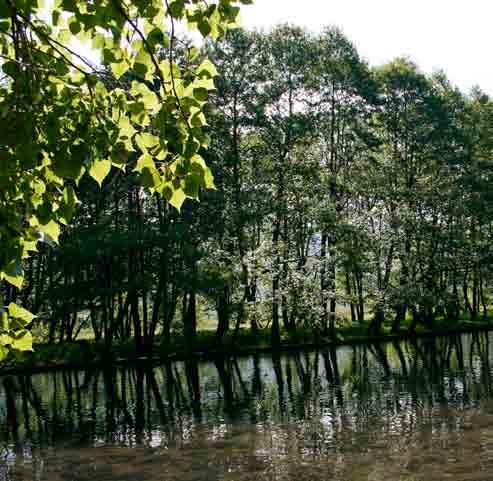
176 176


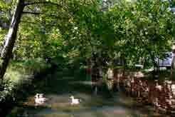
177 Vend pushimi dhe çlodhjeje Relaxing and rest area 177
178 Njësitë e Pushtetit Vendor në Qarkun e Korçës Local Government in Korça Region (Communes & Municipalities) Rrethi i Korçës / District of Korça Bashki / Municipalities Korçë Maliq Komuna / Communes Voskopoje Lekas Vithkuq Liqenas Pojan Vreshtas Libonik Pirg Gore Moglice Voskop Drenove Mollaj Bulgarec Rrethi i Pogradec / District of Pogradec Bashki / Municipalities Pogradec Komuna / Communes Hudënisht Buçimas Çërravë Dardhas Trebinjë Proptisht Velçan Rrethi i Kolonjës / District of Kolonjë Bashki / Municipalities Kolonjë Leskovik Komuna / Communes Qendër Leskovik Novoselë Barmash Mollas Çlirim Qendër Ersekë Rrethi i Devollit / District of Devoll Bashki / Municipalities Bilisht Komuna / Communes Qendër Bilisht Hoçisht Progër Miras 178

179 179
180 Fondacioni Njeriu Mjedisi Kultura (HEC) Objektivi kryesor i Fondacionit HEC është të sjellë së bashku elementët e këtij trigoni Njeriun Mjedisin Kulturën dhe t i bëjë ato të funksionojnë si NJË. Fondacioni HEC ka për qëllim të drejtat e njeriut, mbrojtjen e mjedisit, konservimin / restaurimin dhe promovimin e trashëgimisë kulturore, duke përmirësuar në këtë mënyrë cilësinë e jetës, për një të ardhme më të mirë dhe më të qëndrueshme, mes iniciativash lokale, kombëtare dhe ndërkombëtare. Human - Environment Culture Foundation (HEC) HEC Foundation s essential objective is to bring together the elements of this triangle the Human the Environment the Culture, and make that work as ONE. HEC Foundation aims for the human rights, for the environment protection, for the conservation / restoration and promotion of culture heritage, improving in that way the quality of life, for a better and sustainable future, through local, national and international initiatives. SIDA Agjensia Suedeze për Zhvillim Ndërkombëtar Politika afatgjatë e SIDA-s funksionion e përqëndruar në këto pesë fusha të politikave strategjike: Demokraci, të Drejtat e Njeriut dhe Barazia Gjinore; Mundësi të Zhvillimit Ekonomik; Njohuri, Shëndet dhe Zhvillim Social; Zhvillim i Qëndrueshëm Mjedisor; Paqe dhe Siguri; SIDA implementoi me suksess në Rajonin e Korçës projektim Menaxhimi I Mbetjeve të Ngurta në bashkëpunim me qeverisjen locale dhe rajonale. SIDA - Swedish International Development Agency Policy works with a long-term approach with the following five mutually dependent and broad strategic policy areas: Democracy, Human Rights and Gender Equality Economic Opportunities Knowledge, Health and Social Development Environmentally Sustainable Development Peace and Security SIDA implemented successfully in Korça Region the project Solid Waste Management in cooperation with the local and regional government. Fondacioni Kenedi Fondacioni Kenedi është një armë sociale e Kishës Evangjeliste në Korçë. Qëllimi i tij është të haset me nevoja të komunitetit që janë neglizhuar. Disa prej shërbimeve, ofrohen nëpërmjet Klinikës Kenedi, si, përkujdesje për plagë dhe djegie, kujdes për diabetikët, fizioterapi dhe qeradhënie pajisjesh për rehabilitim. Mundëson shërbimin e infermierit në shtëpi. Mësime të veçanta edukimi për fëmijëve, të cilët nuk kanë mundësi të ndjekin shkollën, si dhe për ata fëmijë që u nevojitet përkujdesje e veçantë. Aplikohet një program i përkujdesit për moshën e tretë dhe nevoja specifike të kësaj pjese të popullsisë. Një shembull për t u përmendur është shpërndarja nëpër shtëpi e ushqimit. Një qendër, gjithashtu, për fëmijët në risk (trafikimi, mungese shkollimi, abuzimi, etj.), kërkon të inkurajojë fëmijët për të qenë mirë fizikisht, emocionalisht dhe shpirtërisht, të cilëve u ofrohet në qendër edhe dreka. Zhvillon kurse për mësimin e gjuhës angleze dhe kompjuterit, për individë të moshave të ndryshme. Fondacioni Kenedi bashkëpunon me sektorin publik, duke dhënë ndihmesën e tij në zhvillimin e aktiviteteve të ndryshme në qytet. Kennedy Foundation The Kennedy Foundation is the social arm of the Korça Evangelical Church. Its purpose is to meet various needs of the community that are otherwise overlooked. Some of their services are provided through the Kennedy Clinic which includes wound and burn care, management of diabetes, physical therapy, and rental of equipment for rehabilitation. Home health nursing visits are also available. Special education classes are given to children unable to attend school as well as for those who require special tutoring. A program for the elderly cares for special needs of this population. An example is home delivery of a hot meal. A Centre for Children at-risk (poor education, trafficking, abuse, etc.) seeks to encourage their physical, emotional and spiritual well-being. They also receive a hot cooked meal. English and computer classes are available for people of different ages. The Kennedy Foundation works in cooperation with the city to support different festivals and city activities. Organizata Botërore e Turizmit (KBOBT) Organizata Botërore e Turizmit (OBT), është agjensi e specializuar e Kombeve të Bashkuara, e vetmja organizatë ndërqeveritare që shërben si një forum global për politikat dhe çështjet e turizmit. Anëtarët e saj shtrihen në 161 vende dhe territore, përkrah 409 Anëtarësimeve nga sektori publik dhe sektori privat. Misioni i KBOBT-së është promovimi dhe zhvillimi i turizmit, si mjet i rëndësishëm për forcimin e paqes dhe mirëkuptimit në nivel ndërkombëtar, për zhvillimin e ekonomisë dhe 180
181 tregut ndërkombëtar. Në vitin 2002, KBOBT-ja filloi Programin ST-EP (Turizëm i Qëndrueshëm për Eliminimin e Varfërisë), me qëllim uljen e nivelit të varfërisë, nëpërmjet zhvillimit dhe promovimit të formave të qëndrueshme të turizmit. KBOBT-ja u mbështet për programin ST-EP nga Qeveria e Republikës së Koresë, nga Organizata Hollandeze për Zhvillim SNV, nga Qeveria Italiane, Agjensia Spanjolle për Zhvillim AECID, si dhe shumë nga agjensi të tjera zhvillimi dhe organizma të sektorit privat. Me këtë mbështetje, në fillim të vitit 2010, janë dhënë 90 projekte ST- EP, duke ndihmuar 31 vende në Afrikë, Azi, Amerikë Latine dhe në Ballkan (duke përfshirë edhe një projekt në Rajonin e Korçës), si dhe 3 projekte rajonale ST-EP, në Afrikën Perëndimore dhe Jugore. World Tourism Organization (UNWTO) The World Tourism Organization (UNWTO), a specialized United Nations agency, is the only intergovernmental organization that serves as a global forum for tourism policy and issues. Its Members include 161 countries and territories as well as 409 Affiliate Members from the public and private sectors. UNWTO s mission is to promote and develop tourism as a significant means of fostering international peace and understanding, economic development and international trade. In 2002, UNWTO launched the ST-EP (Sustainable Tourism for the Elimination of Poverty) Programme, aimed at reducing poverty levels through developing and promoting sustainable forms of tourism. UNWTO received support for the ST-EP Programme from The Government of the Republic of Korea, the Netherlands Development Organisation SNV, the Italian Government, the Spanish Development Agency AECID and a wide range of other development agencies and private sector organisations. With this support, in the beginning of ST-EP projects had been launched, benefiting 31 countries in Africa, Asia, Latin America and the Balkans (including a project in Korca Region), as well as 3 regional ST-EP projects in West and Southern Africa. Fondacioni ST-EP (Turizëm i Qëndrueshëm për Eliminimin e Varfërisë) Fondacioni ST-EP ka për objektiv kryesor eliminimin e varfërisë mes pragramesh dhe projektesh, për zhvillimin e një turizmi të qëndrueshëm, që mund të arrihet duke ruajtur mjedisin kulturor dhe natyror, duke kontriubuar kështu në Objektivat e Zhvillimit të Mijëvjeçarit. Fondacioni ST-EP kontriubon për mbrojtjen e trashëgimisë natyrore dhe kulturore dhe zhvillimin social-ekonomik, duke kooperuar me organizata ndërkombëtare, me qeverisjen dhe autoritete që lidhen me të, fondacione, korporata private, shoqëri dhe individë, që janë të gatshëm të kontriubojnë për të njëjtat qëllime, uljen e nivelit të varfërisë, mes projektesh dhe iniciativash, për një turizëm të qëndrueshëm. ST-EP Foundation (Sustainable Tourism for the Elimination of Poverty) ST-EP Foundation s main aim is to promote poverty elimination through sustainable tourism development programmes and projects that can be carried out while preserving the cultural and natural environment, thus contributing to the Millennium Development Goals. ST-EP Foundation contributes to the safeguarding of natural and cultural heritage and socio-economic development by cooperating with international organizations, governments and related authorities, foundations, private corporations, associations and individuals who are willing to contribute to the same goals of reducing poverty levels through sustainable tourism projects and initiatives. SNV në Shqipëri SNV-ja filloi aktivitetin në Shqipëri në vitin 1993 dhe operon me fonde nga Qeveria Hollandeze, si dhe nga donatorë të tjerë, mes marrëdhëniesh bilaterale dhe multilaterale. Strategji Kombëtare për Zhvillim dhe Integrim (NSDI) Në këtë kuadër të strategjive sektoriale dhe atyre të ndërthurrura, SNV-ja këshillon dhe udhëheq për shtim të qëndrueshëm dhe të paanshëm të prodhimit, punësimit dhe të ardhurave për femrat dhe meshkujt në zonat rurale. Zhvillimi Rural SNV në Shqipëri ka fokusuar shërbimet e saj në tre sektorë: Bujqësi, Pyje dhe Turizëm, që korrespondojnë më së miri me axhendën e zhvillimeve të BE-së dhe atyre kombëtare. Mes programesh dhe veçanërisht në fushën e zhvillimit rural SNV-ja është fokusuar tek qeverisja, përjashtimi gjinor dhe social, si çështje të mprehta. SNV në Shqipëri kooperon me një numur partnerësh lokalë, kombëtarë dhe ndërkombëtarë. SNV in Albania SNV strated its work in Albania in 1993 and operates with funding from the Netherlands Government and other bilateral or multilateral donors. National Strategy for Development and Integration (NSDI) Within this broader framework and its sectorial and cross-cutting strategies, SNV advice leads to increased sustainable and equitable production, employment and income for men and women in rural areas. Rural Development SNV in Albania focused its services for impact in three sectors: Agriculture, Forestry and Tourism, which correspond well with EU and national development agendas. Throughout this programme and especially in rural development SNV has focused on governance, gender and social inclusion as cross cutting issues. SNV in Albania cooperates with numerous local, national and international partners. 181
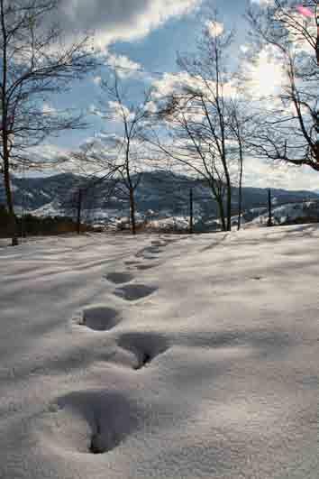
182 182
183 183
184 184
185 185
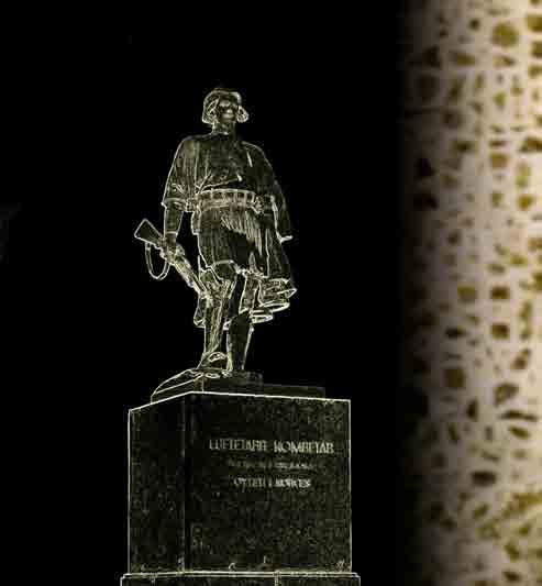
186 186
Albania Official name: Total area Urban-rural population Form of government Urban Rural:
 Albania Official name: Republika e Shqipërisë (Republic of Albania) Form of government: unitary multiparty republic with one legislative house President: Ilir Meta Prime Minister: Edi Rama Capital: Tirana
Kisha e Lindjes së Hyjlindjes tek pazari i Vjetër, Përmet * Numri i shtëpive (haneve) ose I popullsisë 1431/32 42 hane (2-3 shtëpi për çdo hane)
 ose I popullsisë 1431/32 42 hane (2-3 shtëpi për çdo hane)") Kisha e Lindjes së Hyjlindjes tek pazari i Vjetër, Përmet * Dr. Kostantinos Gjakumis, Bizantinolog Nga Zoti Joan Stratoberdha, Arkitekt Përmbledhje Pas vlerësimit të Kishës Lindja e Hyjlindëses në Pazarin
Kisha e Lindjes së Hyjlindjes tek pazari i Vjetër, Përmet * Dr. Kostantinos Gjakumis, Bizantinolog Nga Zoti Joan Stratoberdha, Arkitekt Përmbledhje Pas vlerësimit të Kishës Lindja e Hyjlindëses në Pazarin
The UK Linguistics Olympiad 2018
 Problem 10. Tirana tourist You are visiting a town close to the Albanian capital Tirana. The man at the information centre gives you a map with a key to its symbols 1 ; these are shown below. He also gives
Turizmi. Drejt një КОН. Alternativ. ТУРИЗАМ Студиски извештај АЛТЕРНАТИВEН. Raport Studimi REPORT. Raport Studimi
 1 Drejt një Turizmi Alternativ Raport Studimi TOWARDS AN ALTERNATIVE TOURISM REPORT КОН АЛТЕРНАТИВEН ТУРИЗАМ Студиски извештај This project is funded by The European Union Raport Studimi 2 Drejt një Turizmi
Speci Shqipëri
 Shqipëri 2017 2018 baburra Vedrana F1 Është hibrid shumë i hershëm i llojit të Baburrës së bardhë-gjelbër me tipar gjysëm të hapur. Ka një sistem rrënjor shumë të fuqishëm i cili i mundëson një rritje
TOEFL ibt Quick Prep. Volume 1. Go anywhere from here.
 TOEFL ibt Quick Prep Volume 1 Go anywhere from here. INTRODUCTION Introduction ABOUT THE TOEFL ibt TEST The TOEFL ibt test measures your ability to use and understand the English language as it is read,
CONTINUITY OF TOURISTIC DEVELOPMENT IN THE COMMUNE OF PUSTEC
 CONTINUITY OF TOURISTIC DEVELOPMENT IN THE COMMUNE OF PUSTEC M.Sc. Ema MUSLLI PhD Candidate, University of Tirana ALBANIA ABSTRACT The commune of Pustec is a small administrative unit in the region of
Research Article. Late Neolithic, Calcolithic and Late Bronze Age Fortifications in Southeast Albania. 1. Introduction
 Research Article Late Neolithic, Calcolithic and Late Bronze Age Fortifications in Southeast Albania Froseda Angjellari Tola Archaeology Keywords: Fortifications, Late Neolithic, Chalcolithic, Late Bronze
Extract from Tirana Cityspots by Tim Clancy
 Extract from Tirana Cityspots by Tim Clancy The following information is extracted from "Tirana Cityspots by Tim Clancy" with the permission of Thomas Cook Publishing. This is the first ever guidebook
Join us in the Preservation and Promotion of the Traditional, Cultural and Natural Resources of Korca.
 Legend Biotourism spot Historical Monument Natural Monument Hidrography Religious Monument Biotourist map of Korça Region Mouse Cross-border point City Village National Border Study Area Main Road Secondary
Places to visit in Minsk: city guide for Meet Magento Belarus guests
 Places to visit in Minsk: city guide for Meet Magento Belarus guests Ksenia Dobreva Jun 3, 2015 Meet Magento Belarus is approaching! As we re expecting guests and speakers from other countries, we thought
REPUBLIKA E SHQIPËRISË MINISTRIA E ARSIMIT DHE E SHKENCËS AGJENCIA KOMBËTARE E PROVIMEVE PROVIMI ME ZGJEDHJE I MATURËS SHTETËRORE 2013
 KUJDES! MOS DËMTO BARKODIN BARKODI REPUBLIKA E SHQIPËRISË MINISTRIA E ARSIMIT DHE E SHKENCËS AGJENCIA KOMBËTARE E PROVIMEVE PROVIMI ME ZGJEDHJE I MATURËS SHTETËRORE 2013 LËNDA: ANGLISHT, GJUHË E HUAJ E
こだわりの旅 バルカン半島. Croatia~Montenegro~Albania. コース No P Site seeing FD. Lunch in local restaurant
 こだわりの旅 バルカン半島 コース No P21600 Croatia~Montenegro~Albania Day 1. Dubrovnik Dubrovnik, that is a remarkably well-preserved example of a late-medieval walled city, with a regular street layout. Among the outstanding
Zhulieta Harasani, MBA PhD. Petrit Harasani The shared Transboundary Natural and Cultural Heritage of the Lake Ohrid Region
 Zhulieta Harasani, MBA PhD. Petrit Harasani The shared Transboundary Natural and Cultural Heritage of the Lake Ohrid Region The natural and cultural heritage of the Ohrid Region comprises the ancient city
A common vision of the future AULEDA. Local Economic Development Agency. Local Staff VLORE, ALBANIA. Local Economic Development Agency.
 A common vision of the future AULEDA Local Economic Development Agency Local Staff VLORE, ALBANIA Local Economic Development Agency Slide No 1 Mission AULEDA is a professional non-governmental organization
Publisher Non-governmental organization Emancipimi Civil Ma Ndryshe EC Ma Ndryshe
 P R I Z R E N I N Ë R E T R O V I Z O R E P R I Z R E N T H R O U G H T H E R E T R O - V I S O R Publikues Organizata jo-qeveritare Emancipimi Civil Ma Ndryshe EC Ma Ndryshe Financuar nga CHwB - Trashëgimia
UNIVERSITETI I PRISHTINËS FAKULTETI EKONOMIK Studime postdiplomike. BDH Relacionale. Pjesa 2: Modelimi Entity-Relationship. Dr.
 UNIVERSITETI I PRISHTINËS FAKULTETI EKONOIK Studime postdiplomike BDH Relacionale Pjesa 2: odelimi Entity-Relationship Dr. ihane Berisha 1 Qëllimi Pas kësaj ligjërate do të jeni në gjendje : Të përshkruani
ORIKUM PLANI I ZHVILLIMIT LOKAL BASHKIA FONDI SHQIPTAR I ZHVILLIMIT BASHKIA ORIKUM ALBANIAN DEVELOPMENT FUND
 PLANI I ZHVILLIMIT LOKAL FONDI SHQIPTAR I ZHVILLIMIT B ALBANIAN DEVELOPMENT FUND BASHKIA ORIKUM PLANI I ZHVILLIMIT LOKAL BASHKIA K ppublikim është realizuar në kuadër të projektit Ky Punët në komunitet
ARSIMI I LARTË NË SHQIPËRI
 UNIVERSITETI I TIRANËS FAKULTETI I HISTORISË DHE I FILOLOGJISË DEPARTAMENTI I HISTORISË ARSIMI I LARTË NË SHQIPËRI 1946-1968 (PUNIM DOKTORATE) PUNOI Msc. Çlirim Duro UDHËHEQËS SHKENCOR Prof.As. Dr. Ajet
TURIZMI HISTORIK NË QARKUN E BERATIT: PROBLEMET DHE PERSPEKTIVAT
 REPUBLIKA E SHQIPERISE UNIVERSITETI ALEKSANDER MOISIU DURRES FAKULTETI I SHKENCAVE POLITIKE-JURIDIKE DEPARTAMENTI ADMINISTRIM PUBLIK MASTER NE ADMINISTRIM PUBLIK Adresa: Lagja 1, Rr. Currilave, Durres
Gara Math Kangaroo Kosovë Klasa 3-4
 PJESA A: Çdo përgjigje e saktë vlerësohet me 3 pikë 1. Cila nga pjesët A - E duhet të vendoset në mes të dy pjesëve të dhëna ashtu që tëvlejë barazia? 2. Ardiani shikoi në dritare. Ai sheh gjysmën e kengurave
SAMt. INCA tour Chile - Peru. Total Kilometers days 10 nights
 An ADVENTURE of an incredible mixture of mystical archaeology sites and historical monuments, amazing nature combined with one of the oldest and most diverse cultures in South America. LIFE IS NOT - WITHOUT
UNIVERSITETI I TIRANËS FAKULTETI I EKONOMISË DEPARTAMENTI MARKETING-TURIZËM DISERTACION
 UNIVERSITETI I TIRANËS FAKULTETI I EKONOMISË DEPARTAMENTI MARKETING-TURIZËM DISERTACION NGA MARKETINGU MIKS TE ALTERNATIVAT E BASHKË-KRIJIMIT SFIDAT E MARKETINGUT TË QENDRUESHËM PËR TRASHËGIMINË KULTURORE
Second Erasmus+ International Teaching and Training Week Innovations and Entrepreneurship in Education and Business
 Plovdiv is the second largest city in Bulgaria and an administrative center of Plovdiv County. It is situated in the Upper Thracian Plain (Gornotrakiyska Nizina), on the both banks of the Maritsa river.
MONTENEGRO EXPLORER 7 days
 7 days Countries visited Montenegro Tour Highlights Ottoman architecture of Podgorica Spectacular Tara gorge See the Monastery Ostrog perched on the cliffs The pretty Riviera town of udva Sample Njegusi's
Effect of Geography on Ancient Greece. Chapter 4-1
 Effect of Geography on Ancient Greece Chapter 4-1 Greek Geography Greece is a peninsula that is covered by many mountains. Geography Continued. It is located in the heart of the Mediterranean Sea. The
ASOCIACIONI KANGOUROU SANS FRONTIÈRES (AKSF) TESTI Testi për Klasat 1-2
 TESTI Testi për Klasat 1-2") ASOCIACIONI KANGOUROU SANS FRONTIÈRES (AKSF) GARA NDËRKOMBËTARE E MATEMATIKËS KANGAROO K O S O V Ë TESTI 2017 Testi për Klasat 1-2 Emri dhe mbiemri: Datëlindja: Math Kangaroo Contest Kosovo (MKC-K) www.kangaroo-ks.org
ASOCIACIONI KANGOUROU SANS FRONTIÈRES (AKSF) GARA NDËRKOMBËTARE E MATEMATIKËS KANGAROO K O S O V Ë TESTI 2017 Testi për Klasat 1-2 Emri dhe mbiemri: Datëlindja: Math Kangaroo Contest Kosovo (MKC-K) www.kangaroo-ks.org
Towards Strengthened Governance of the Shared Trans-boundary Natural and Cultural Heritage of the Lake Ohrid Region
 Towards Strengthened Governance of the Shared Trans-boundary Natural and Cultural Heritage of the Lake Ohrid Region Zhulieta Harasani, Albania OCTOBER 2015 THE SHARED TRANSBOUNDARY NATURAL AND CULTURAL
CURRICULUM VITAE. 1. Family Name: Gashi 2. First Name: Muharrem 3. Nationality: Kosovo 4. Date of Birth Gender: M. 6.
 CURRICULUM VITAE 1. Family Name: Gashi 2. First Name: Muharrem 3. Nationality: Kosovo 4. Date of Birth 20.12.1959 5. Gender: M. 6. Contact details: 7. Education Degree: Email: rremi_77@hotmail.com Tel:
Deir al Qilt Locality Profile
 Deir al Qilt Locality Profile Prepared by The Applied Research Institute Jerusalem Funded by Spanish Cooperation 2012 Acknowledgments ARIJ hereby expresses its deep gratitude to the Spanish agency for
Mediterranean Europe
 Chapter 17, Section World Geography Chapter 17 Mediterranean Europe Copyright 2003 by Pearson Education, Inc., publishing as Prentice Hall, Upper Saddle River, NJ. All rights reserved. Chapter 17, Section
FICHE DE PRÉSENTATION DE PROJET TITRE : BOURGAS REGION - FIRE DANCE, BIRDS, NATURE AND SEA PAYS : BULGARIE
 FICHE DE PRÉSENTATION DE PROJET TITRE : BOURGAS REGION - FIRE DANCE, BIRDS, NATURE AND SEA PAYS : BULGARIE 1. Background Bourgas region is the most south-eastern part of Bulgaria. It is located on the
Top image: Background image:
 ATHENS, ONE OF THE OLDEST CITIES in the world, has been continuously inhabited for at least 7,000 years. A place of prominence since ancient times, Athens is city of monumental beauty and classical scholarship.
Argo ship of the Argonauts
 Argo ship of the Argonauts Centaur Chiron educating young Achilles Join us on a spectacular full day tour exploring both sides of the Pelion peninsula (east and west), having the chance to admire both
Lake Ohrid. our shared responsibilities and benefits. Protecting
 Towards strengthened governance of the shared transboundary natural and cultural heritage of the Lake Ohrid region Protecting Lake Ohrid region our shared responsibilities and benefits This publication
Atlantic Way to Santiago HISTORICAL COASTAL SUMMER
 Atlantic Way to Santiago HISTORICAL COASTAL SUMMER 2018 www.portugalnaturetrails.com info@portugalnaturetrails.com Atlantic Way to Santiago ADVENTURE NATURE DESCRIPTION Riding on the most interesting and
CURRICULUM VITAE. Institucioni: Universiteti i Prishtinës, Fakulteti Juridik Data: Niveli: Doktor i Shkencave Juridike Dr.sc.
 CURRICULUM VITAE 1. Mbiemri: Kryeziu 2. Emri: Kadri 3. Nacionaliteti: Kosovar 4. Data e lindjes 25.08.1958 5. Gjinia: M 6. Kontakti: Prizren Email: kadri.kryeziu@hotmail.com 7. Niveli arsimor: Tel: +386
Tel: Natyrore, Departamenti i Matematikës
 CURRICULUM VITAE 1. Mbiemri: Gashi 2. Emri: Menderes 3. Nacionaliteti: Shqiptar 4. Data e lindjes: 5.6.1964 5. Gjinia: Mashkull 6. Detajet kontaktuese: 7. Niveli arsimor: Email: menderes_gashi@yahoo.com
Dinner our first night in Saranda was at the waterfront restaurant in lower left.
 Travelogue 4 Saranda to Gjirokaster After the long drive down the Albanian coast, we arrived in the popular seaside resort of Saranda, which is said to have 300 sunny days a year. We stayed two nights
S T U D I M PËRFSHIRJA E TRASHËGIMISË KULTURORE NË PLANIFIKIM HAPËSINOR
 PËRFSHIRJA E TRASHËGIMISË KULTURORE NË PLANIFIKIM HAPËSINOR S T U D I M Rastet e studimit: Draft Plani Hapësinor i Kosovës 2010-2020+ Planet përkatëse komunale: Komuna e Mitrovicës, Komuna e Vushtrrisë,
Ancient Greece. Written by: Marci Haines. Sample file. Rainbow Horizons Publishing Inc. ISBN-13:
 Ancient Greece Written by: Marci Haines Rainbow Horizons Publishing Inc. Tel: 1-800-663-3609 Fax: 1-800-663-3608 Email: service@rainbowhorizons.com www.rainbowhorizons.com ISBN-13: 978-1-55319-085-1 Copyright
THE MACEDONIAN HERITAGE
 Head office Slovenia Dunajska cesta 109, Ljubljana T: +386 1 232 11 71 E: adriatic@liberty-int.com LIBERTY ADRIATIC www.liberty-adriatic.com www.impact-tourism.net Croatia offices Zagreb: Ilica 92/1; T:
DRENOVË PLANI I ZHVILLIMIT LOKAL KOMUNA FONDI SHQIPTAR I ZHVILLIMIT KOMUNA DRENOVË ALBANIAN DEVELOPMENT FUND
 PLANI I ZHVILLIMIT LOKAL FONDI SHQIPTAR I ZHVILLIMIT K ALBANIAN DEVELOPMENT FUND KOMUNA DRENOVË PLANI I ZHVILLIMIT LOKAL KOMUNA Ky publikim është realizuar në kuadër të projektit Punët P në komunitet III,
Most Famous Sites of Athens and visit of Temple of Poseidon in Cape Sounion. Acropolis of Athens, New Acropolis Museum and Cape Sounion
 www.lifestyletravel.gr E-mail: info@lifestyletravel.gr Tel.: +30 2109938642 /+30 2109934980 Tour Duration: 10 hrs Live Guide in English Most Famous Sites of Athens and visit of Temple of Poseidon in Cape
 Rolling Hills Luxury Residences do të jetë një komunitet i rrethuar luksoz: më i miri në klas dhe i pari i këtij lloji në Shqipëri. Kompleksi do të ketë 113 vila luksoze, një Club House, park dhe sipërfaqe
ANALIZA SOCIO-EKONOMIKE DHE STUDIMI MBI ZHVILLIMIN E TURIZMIT
 ANALIZA SOCIO-EKONOMIKE DHE STUDIMI MBI ZHVILLIMIN E TURIZMIT Mbështetje për planifikimin, zonimin dhe zhvillimin e Zonës së Mbrojtur Detare në Gjirin e Porto Palermos (Shqipëri), bazuar në njohuri të
PLANI RAJONAL I TRASHËGIMISË VERI
 PLANI RAJONAL I TRASHËGIMISË VERI 2015-2018 Plani Rajonal i Trashëgimisë Veri 2015-2018 MAJ 2015 Prishtinë Ky dokument është prodhuar brenda kornizës së projektit të përbashkët BE/KE - Përkrahja për Promovimin
HISTORIC CITIES IN DEVELOPMENT
 HISTORIC CITIES IN DEVELOPMENT Centuries of history has moulded the historic cities of Tanzania and Palestine into a cultural fusion of religions, traditions and ethnic groups. Rich and important, Zanzibar,
3 / ACTA SCIENTIARUM
 3 / ACTA SCIENTIARUM Ç lloj BASHKIMI? Mbi hapësirën e përbashkët ekonomike Shqipëri -Kosovë Akte të forumit akademik Nën kujdesin e z.behgjet PACOLLI ish-president i Republikës së Kosovës 4 Ç lloj bashkimi?
Roli i arsimit në zhvillimin ekonomik të vendit
 Roli i arsimit në zhvillimin ekonomik të vendit Anemonë Zeneli Gusht, 2013 Arsimi është një ndër shtyllat kryesore të një shoqërie të shëndoshë dhe të zhvilluar. Në mënyrë që një shtet të zhvillohet në
Parma is happy to welcome the IPS in Nelson Marmiroli and the Department of Environmental Sciences University of Parma
 Parma is happy to welcome the IPS in 2010 Nelson Marmiroli and the Department of Environmental Sciences University of Parma Parma Parma A friendly city for modern living. Busy, but not chaotic; orderly
this project is funded by the european Union
 this project is funded by the european Union v Karakteristikat EKONOMIKE Economic Characteristics CENSUSI I POPULLSISË DHE BANESAVE 2011 POPULATION AND HOUSING CENSUS 2011 Karakteristikat Ekonomike Economic
PLANI RAJONAL I TRASHËGIMISË QENDËR
 PLANI RAJONAL I TRASHËGIMISË QENDËR 2015-2018 Plani Rajonal i Trashëgimisë Qendër 2015-2018 MAJ 2015 Prishtinë Ky dokument është prodhuar brenda kornizës së projektit të përbashkët BE/KE - Përkrahja për
SPA & LEISURE RIU PRAVETS. Tour Itinerary
 SPA & LEISURE RIU PRAVETS Tour Itinerary Enjoy a day of leisure and 5-star SPA in the foothillls of the Balkan Mountain, an hour away from Sofia. Riu Pravets complex offers a variety of activities such
The Cultural Heritage Architecture of Luang Prabang: The Role in Tourism and Preservation Sectors
 The Cultural Heritage Architecture of Luang Prabang: The Role in Tourism and Preservation Sectors Yanin Rugwongwan, King Mongkut s Institute of Ladkrabang, Thailand The Asian Conference on Cultural Studies
Potenciali për zhvillimin e ekoturizmit
 Institute for Nature Conservation in Albania Instituti për Ruajtjen e Natyrës në Shqipëri Potenciali për zhvillimin e ekoturizmit Parku Kombëtar Detar Karaburun - Sazan MedMPAnet Institute for Nature Conservation
Sports University of Tirana
 Sports University of Tirana The Sports University of Tirana is the only institution of high education of this kind in the Republic of Albania, aiming at qualifying teachers of physical education and sport
Discover Athens City s Greatest Treasures. on this Athens Morning Sightseeing Tour
 www.lifestyletravel.gr E-mail: info@lifestyletravel.gr Tel.: +30 2109938642 /+30 2109934980 Tour Duration: 5 hrs Live Guide in English Discover Athens City s Greatest Treasures on this Athens Morning Sightseeing
RESUME OF EDUCATION FAIR 2016
 RESUME OF EDUCATION FAIR 2016 Summary and information from 10 th Edition of Education Fair 21-22 April 2016 Exhibitors of Education Fair Visitors of Education Fair Statistics Video Documentary Photo Gallery
Authentic Italian Experiences
 YOGA & HEALTHY FOOD IN APULIA, 26 April - 2 nd May 2018, 6 nights Guests: max 12, sharing double rooms Enjoy the peace, genuine atmosphere and amazing cuisine. An unforgettable yoga holiday in Apulia!
Itinerary: Programme Day 1: 18th May 2016 (Wednesday) Budva Accomodation
 Budva Accomodation") Programme Itinerary: Programme Day 1: 18th May 2016 (Wednesday) Budva Accomodation Welcoming of Guests at Podgorica Airport, Tivat Airport or Dubrovnik Airport Transfer to Hotel Montenegro Beach Resort
Programme Itinerary: Programme Day 1: 18th May 2016 (Wednesday) Budva Accomodation Welcoming of Guests at Podgorica Airport, Tivat Airport or Dubrovnik Airport Transfer to Hotel Montenegro Beach Resort
INTRODUCTION ITINERARY PERU - LUXURY MACHU PICCHU EXPERIENCE TRIP CODE PETSCLX DEPARTURE
 INTRODUCTION The Chimu Collections range consists of boutique properties, cruises & itineraries, throughout Latin America, designed for travellers seeking unique experiences. We have taken the highlights
PRIORITETET E BANORËVE TË KOMUNËS SË KAMENICËS
 PRIORITETET E BANORËVE TË KOMUNËS SË KAMENICËS Prishtinë, qershor 2015 PRIORITETET E BANORËVE TË KOMUNËS SË KAMENICËS Ky publikim ёshtё pjesё e projektit Qytetarё aktiv komuna tё pёrgjegjshme dhe transparente,
Profesionalizmi Në Shërbimin Turistik, Gur Themeli Për Zhvillimin e Turizmit në Shqipëri
 PhD Cand. Mimoza Kotollaku mimozakotollaku@yahoo.it Fakulteti Ekonomik, Universiteti A.Xhuvani, Elbasan Profesionalizmi Në Shërbimin Turistik, Gur Themeli Për Zhvillimin e Turizmit në Shqipëri Abstract
the st jovan kaneo is built in the shape of a cross and dates to the 1200s
 the st jovan kaneo is built in the shape of a cross and dates to the 1200s 62 Wizz magazine JUNE-JULY 2012 from city to shore Make tracks from Skopje s historic centre to the magnificent Lake Ohrid Words
INTRODUCTION ITINERARY PERU - LUXURY MACHU PICCHU EXPERIENCE TRIP CODE PETSCLX DEPARTURE. Daily DURATION. 5 Days LOCATIONS. Peru
 INTRODUCTION The Chimu Collections range consists of boutique properties, cruises & itineraries, throughout Latin America, designed for travellers seeking unique experiences. We have taken the highlights
VALA MAR RESIDENCES THE REASON TO INVEST IN
 VALA MAR RESIDENCES THE REASON TO INVEST IN A L B A N I A This country is a dizzying mix of religion, styles, cultures and landscapes, from the Orthodox, Sunni, Muslim, Albanians, from idyllic beaches
Zhvillimet politike në Kosovë
 UNIVERSITETI I PRISHTINËS FAKULTETI FILOZOFIK DEPARTAMENTI I HISTORISË SHPEND AVDIU REZYME E PUNIMIT TË DOKTORATËS Zhvillimet politike në Kosovë 1912-1915 Prishtinë, 2017 Objekt i trajtimit të këtij punimi
Summer Tour to Georgia (7 days)
") Summer Tour to Georgia (7 days) Day 1 st 2 nd, Tbilisi, Coffee Break and Sweets - 11.00 Lunch - 14.00-15.00, Georgian Cuisine Completion of the tour - 19.00 Dinner - 20:00, Overnight stay at the Hotel
Summer Tour to Georgia (7 days) Day 1 st 2 nd, Tbilisi, Coffee Break and Sweets - 11.00 Lunch - 14.00-15.00, Georgian Cuisine Completion of the tour - 19.00 Dinner - 20:00, Overnight stay at the Hotel
ZAGREB SPLIT DUBROVNIK
 ZAGREB SPLIT DUBROVNIK 06 NIGHTS / 07 DAYS Starting USD 1475 from 01APR till 20DEC, 2017 Per person in double Day 01: Arrival to Zagreb airport. Private transfer to the hotel. Overnight at the hotel in
PLJEVLJA the Northern Gate of Montenegro
 Welcome to Pljevlja PLJEVLJA the Northern Gate of Montenegro The municipality of Pljevlja is situated in the far north of Montenegro surrounded by wooded and gentle mountainous countryside and carved with
Suggested Arrival Group Flight If you arrive on this flight, group transportation will be provided to your lodging.
 UCF ABROAD ITINERARY Program: Greek Art & Architecture/Greek Science & Astronomy Dates: June 24 - July 11, 2018 Flight Airline & Number Departure Time from MCO Flight Arrival Time Suggested Arrival Group
Adventure Tour to Georgia (5 Days) Day 1 st, Tbilisi
 Day 1 st, Tbilisi") Adventure Tour to Georgia (5 Days) Day 1 st, Tbilisi Departure from the hotel - 08.00 Coffee break and sweets - 11.00 Lunch - 14.00-15.00, Georgian cuisine End of the tour - 19:00, transfer to Tbilisi
Adventure Tour to Georgia (5 Days) Day 1 st, Tbilisi Departure from the hotel - 08.00 Coffee break and sweets - 11.00 Lunch - 14.00-15.00, Georgian cuisine End of the tour - 19:00, transfer to Tbilisi
GUIDED CYCLE TOUR - 8 DAYS / 7 NIGHTS
 GUIDED CYCLE TOUR - 8 DAYS / 7 NIGHTS Experience the atmosphere of Bulgarian monasteries and history on a bike. This tour is not just a circuit of some of the most interesting Bulgarian monasteries. It
Bulgaria. /Training and research/
 Bulgaria /Training and research/ Bulgaria is a country, the history of which dates further back in time. The lands we occupy now, used to be the lands of the ancient Thracians, the Slavic and the Proto-Bulgarians.
Geography and Early Greek Civilization
 Geography and Early Greek Civilization Do Now How does geography influence how you interact with your neighbors? Learning Targets and Intentions of the Lesson I Want Students to: 1. KNOW the differences
BULETINI MUJOR KLIMATIK
 ISSN 2521-831X BULETINI MUJOR KLIMATIK Universiteti Politeknik i Tiranës Instituti i Gjeoshkencave, Energjisë, Ujit & Mjedisit Tirana 2017 ISSN 2521-831X Klima.Shqiperia@gmail.com GUSHT2017 Nr. 8 Vlerësimi
Turkey Targets Archaeological Sites in Afrin
 Turkey Targets Archaeological Sites in Afrin Tourism and Protection of Relics Commission Aljazeera Region /http://desteya-shunwaran.com 2/2/2018 In Afrin region, there are hundreds of important archaeological
MYKONOS & SANTORINI
 www.ctcgreece.com info@ctcgreece.com 1-888-711-4500 MYKONOS & SANTORINI This is a sample itinerary: we are happy to customize the trip for you by changing hotels, number of nights, what s included, etc.
2690 WESTON ROAD, STE 200, WESTON FL TEL: FAX:
 Croatian Dream Tour Day 1 - Arrive in Dubrovnik Welcome to Dubrovnik, centuries old fortified jewel on the clear blue Adriatic coast, included on the list of UNESCO World Cultural Heritage. Get to know
Summer University Course on Cultural Heritage for Students of Koç
 Summer University Course on Cultural Heritage for Students of Koç University Central European University, Budapest June 2017 Course structure and syllabus Course director: Prof. J. Laszlovszky Academic
THE BELGRADE FORTRESS
 Places to visit in Belgrade: Option 1: Visit of Kalemegdan fortrest and its lagoons. After a visit, walk to The residence of Princess Ljubica to drink coffee and listen to the historic story of living
July in Cusco, Peru 2018 Course Descriptions Universidad San Ignacio de Loyola
 July in Cusco, Peru 2018 Course Descriptions Universidad San Ignacio de Loyola For course syllabi, please contact CISaustralia. Please note: Course availability is subject to change. Updated 28 September
Athens, the capital of Greece took its name from the goddess Athena, the goddess of wisdom and knowledge, daughter of Zeus, father of the gods.
 Athens, the capital of Greece took its name from the goddess Athena, the goddess of wisdom and knowledge, daughter of Zeus, father of the gods. Athens one of only a few European capitals that can boast
TRIPOLI APRIL Profile of the Municipality of Tripoli
 TRIPOLI APRIL 2014 Profile of the Municipality of Tripoli 2014 Municipality of Tripoli The Municipality of Tripoli is located in the sender of Peloponnese at 650 meters. It is mountainous area, that extents
REPUBLIKA E SHQIPËRISË MINISTRIA E ARSIMIT DHE E SHKENCËS AGJENCIA QENDRORE E VLERËSIMIT TË ARRITJEVE TË NXËNËSVE
 KUJDES! MOS DËMTO BARKODIN BARKODI REPUBLIKA E SHQIPËRISË MINISTRIA E ARSIMIT DHE E SHKENCËS AGJENCIA QENDRORE E VLERËSIMIT TË ARRITJEVE TË NXËNËSVE I MATURËS SHTETËRORE 2010 LËNDA: GJUHË ANGLEZE E mërkurë,
INTRODUCTION ITINERARY PERU - CUSCO & MACHU PICCHU DISCOVERY TRIP CODE PETSCMD DEPARTURE. Daily DURATION. 5 Days LOCATIONS. Cusco and Machu Pichu
 INTRODUCTION This tour is a suggested itinerary designed by our specialist team! Choose this itinerary or alter it to design your own Journey. We have taken the highlights of Cusco and squeezed them into
27.Total Quality Management and Open Innovation Model in the sector of Tourism (Case of Albania& Montenegro0
 Besarta Vladi Lecture at European University of Tirana (EUT)/ Albania Ilir Rexhepi Managing Director at Kosovo Management Institute (KMI)/ Kosovo Dr.Ermira Qosja- Lecture at European University of Tirana
100 th Anniversary of Armenian Scouting
 100 th Anniversary of Armenian Scouting ANNIVERSARY JAMBOREE August 3-11, 2012 BYURAKAN, ARMENIA For: 14-22 years old (no age limit for Contingent Leaders) Fee: Euros 200 Official languages: English, Armenian
INTRODUCTION ITINERARY PERU - CUSQUENITA (LITTLE CUSCO) TRIP CODE PETSCUS DEPARTURE. Daily DURATION. 4 Days LOCATIONS. Peru
 TRIP CODE PETSCUS DEPARTURE. Daily DURATION. 4 Days LOCATIONS. Peru") INTRODUCTION This tour is a suggested itinerary designed by our specialist team! Choose this itinerary or alter it to design your own Journey. On a limited time frame, or want to visit the Cusco region
INTRODUCTION This tour is a suggested itinerary designed by our specialist team! Choose this itinerary or alter it to design your own Journey. On a limited time frame, or want to visit the Cusco region
Vlerësim i Shpejtë i Zhvillimit të Zinxhirit të Vlerës së Turizmit në Zonën e Pukës
 Vlerësim i Shpejtë i Zhvillimit të Zinxhirit të Vlerës së Turizmit në Zonën e Pukës SHQIPËRI Nëntor 2016 1 Vlerësim i Shpejtë i Zhvillimit të Zinxhirit të Vlerës së Turizmit në Zonën e Pukës (Shqipëri)
Geography. Greece s Physical Geography is: Peninsula (water on three sides) The Peloponnesus. Mountainous Terrain (see Map dark green)
 The Peloponnesus. Mountainous Terrain (see Map dark green)") Grapes Greece Geography Greece s Physical Geography is: Peninsula (water on three sides) The Peloponnesus Mountainous Terrain (see Map dark green) Extends into the Aegean Sea Includes over 2,000 Islands
Grapes Greece Geography Greece s Physical Geography is: Peninsula (water on three sides) The Peloponnesus Mountainous Terrain (see Map dark green) Extends into the Aegean Sea Includes over 2,000 Islands
PALMA Mediterranean Meeting Point. Presentation
 PALMA Mediterranean Meeting Point Presentation PALMA Mediterranean Meeting Point Presentation A. Presentation of the city... 5 1. PALMA TODAY... 10 2. GEOGRAPHICAL SURROUNDINGS... 11 3. HISTORIC CITY CENTRE...
Name: Christos Kardaras Rank: Professor Field of expertise: Modern Greek History
 Name: Christos Kardaras Rank: Professor Field of expertise: Modern Greek History Research interests: The educational and intellectual history of the bondage Hellenism in Epirus, Thessaly, Macedonia and
Name of the Competition. The objective of the Competition
 Name of the Competition Target Group The objective of the Competition The Description International Competition: Luxor Civilization The participants of this competition are from age group under 35 years
Dokedlir2015. Historia e restaurimit të monumenteve të kulturës në Shqipëri pas Luftës së Dytë Botërore
 Dokedlir2015. Historia e restaurimit të monumenteve të kulturës në Shqipëri pas Luftës së Dytë Botërore Doktorant: Edlir ORHANI Udhëheqës shkencor: Prof.dr. Emin RIZA 1 PJESA E PARË HISTORIA E RESTAURIMIT
International Scientific Conference, Tirana, Albania 2011
 International Scientific Conference, Tirana, Albania 2011 Rural tourism: an opportunity for rural development in Republic of Macedonia Authors: Nako Taskov, Ph.D., Dejan Metodijeski, M.Sc., Tatjana Dzaleva,
INTRODUCTION ITINERARY PERU - CUSCO & MACHU PICCHU DISCOVERY TRIP CODE PETSCMD DEPARTURE. Daily DURATION. 5 Days LOCATIONS. Cusco and Machu Pichu
 INTRODUCTION This tour is a suggested itinerary designed by our specialist team! Choose this itinerary or alter it to design your own Journey. We have taken the highlights of Cusco and squeezed them into
Castles. 1. Castle of Drishtit.
 Castles In territory of Albanian there are a series of castles which dates from antiquity in middle ages. Some of these places are still nowadays habituated (Berat). The most important ones are Rozafa
Atlantic Way to Santiago HISTORICAL COASTAL SUMMER
 Atlantic Way to Santiago HISTORICAL COASTAL SUMMER 2018 www.portugalnaturetrails.com info@portugalnaturetrails.com Atlantic Way to Santiago ADVENTURE NATURE DESCRIPTION Riding on the most interesting and