Ports Handbook for Orkney 6th Edition
|
|
|
- Jodie Stanley
- 5 years ago
- Views:
Transcription

1 Ports Handbook for Orkney 6th Edition
 19 Port Health")
2 CONTENTS General Contact Details 4 Introduction 5 Orkney Harbour Authority Area Map 6 Pilotage Services & Pilotage Exemption Certificates 7 Orkney VTS 8 Reporting Points 9 Radar & AIS Coverage Port Passage Planning 12 Suggested tracks Flow, Kirkwall, Stromness Prior notification requirements 16 Preparations for Port Entry 17 Harbour Craft 18 Port Security - (ISPS code) 19 Port Health 20 Port Medical Officers Services 21 Port Waste Reception Facilities 22 Traffic Movements in Orkney 23 Ferry Routes in & around Orkney 24 Fishing Vessel Facilities 25 Diving Support Boats 26 Principal Wreck & Dive Sites in Flow 27 Towage & Tugs Ship to Ship Cargo Transhipments 32 Flotta Oil Terminal Guide to good practice for small vessel bunkering operations 39 Guide to good practice for the disposal of waste materials 40 Fixed Navigation lights Marinas Tidal Atlas Pollution Prevention Guidelines 145 Index to PIERS & HARBOURS 45 Main Piers Data Piers: Burray Burwick Backaland Egilsay Gibraltar Sutherland Graemsay Holm Houton Longhope Lyness Moaness Kirkwall Hatston Hatston Slipway Nouster Moclett Trumland Kettletoft Loth Flow Balfour Stromness Copland s Dock Pole Star Stronsay Whitehall Tingwall Pierowall Rapness Wyre

3 PORTS HANDBOOK 6TH EDITION Contact: Marine Services Harbour Authority Building Orkney KW15 1SD Scotland Tel: +44 (0) Fax: +44 (0) Website: Personnel: Gavin Barr Executive Director Development & Infrastructure The Orkney County Council Act of 1974 authorised the Orkney Islands Council to exercise jurisdiction as a Statutory Harbour Authority and defined the areas in which the new authority was empowered. These were Flow and its approaches, Wide Firth and Shapinsay Sound and included Stromness, Kirkwall and the Flotta Oil Terminal. The Orkney Islands Council Order Confirmation Act 1978 and the Orkney Islands Council Harbour Revision Order 1989 extended jurisdiction to include 12 additional piers and harbours in the northern islands. In order to administer its responsibility as a statutory Harbour Authority, Orkney Islands Council formed the Department of Harbours in As a Harbour Authority, the Council s aim, through Marine Services, is to ensure that Orkney s piers and harbours are operated in a safe and cost effective manner. It is hoped that this handbook, which is intended as a quick reference guide for port users, will help in achieving this aim. Whilst the information contained in this handbook is believed to be correct at the time of printing, the Harbour Authority can assume no responsibility for the accuracy of its contents. For the latest port information, users should consult the port s website or the relevant Admiralty publications and charts. Brian Archibald AFNI Harbour Master and Head of Marine Services, Engineering & Transportation David Sawkins Deputy Harbour Master (Strategy & Support) Capt. Alistair Wylie Deputy Harbour Master (Operations) David Hibbert Senior Technical Superintendant Michael Morrison Business Development Manager The Orkney Islands Council Marine Services offices on the shorefront overlooking Flow. 4 5

4 HARBOUR AUTHORITY AREA Papa Westray North Ronaldsay Nouster PILOTAGE SERVICES & PILOTAGE EXEMPTION CERTIFICATES Harbour Limits Ports, Piers & Harbours Non Harbour Area Piers STROMNESS Graemsay Moaness Hoy MAINLAND ORKNEY Hoy Sound Lyness Houton Longhope Tingwall Finstown Amenity Slip Flow Harbour Area Flotta Rousay Sutherland & Gibralter Pierowall Westray Westray Firth Trumland Wyre Hatston Pier & Terminal Hatston Slip Hoxa Sound Rapness Egilsay KIRKWALL Mocklett St Mary s St Margaret s Hope Shapinsay Balfour Burray Burray South Ronaldsay The North Sound Eday Backaland Eday Firth Loth Stronsay Firth Deerness Amenity Slip Sanday Kettletoft Stronsay West Pier Whitehall Stronsay Orkney Islands Council Marine Services are the Competent Harbour Authority for the following areas:- 1. The competent Harbour Authority area for Flow etc., bounded as follows: commencing at the Out Taings point of Hoy; thence in a straight line to Breckness on Mainland; thence in a generally eastern direction following the line of low water on the southern boundaries of Mainland to the northern end of the northernmost Churchill Barrier; then in a generally southern direction following the western sides of the four Churchill Barriers and the lines of low water on the western boundaries of the islands of South Ronaldsay (other than Swona) to Brough Ness; thence in a generally western direction by a straight line to the southernmost part of Swona and a straight line from that point to Brims Ness on South Walls on the island of Hoy; thence following the line of low water on the western and northern side of Aith Hope and the seaward boundaries of South Walls and of Hoy to the point of commencement. 2. The Competent Harbour Authority area for Wide Firth/Shapinsay Sound area, bounded as follows: commencing at Harpy Taing on Mainland; thence in a straight line to Strombery on Shapinsay; thence following the line of low water on the southern boundary of Shapinsay to Hacksness; thence in a straight line to Rerwick Point on the Mainland; thence in a generally westerly and northeasterly direction following the line of low water on part of the northern boundary of Mainland to the point of commencement. Pilotage is compulsory within the Competent Harbour Authority areas for the following ships: 1. All passenger vessels over 65 metres overall length; 2. All other vessels over 80 metres overall length; 3. All vessels under tow where the combined overall length of tow is over 65 metres. 4. All vessels over 300GT carrying persistent oils in bulk. Vessels requiring or requesting a pilot must provide a minimum of 2hrs notice to Orkney VTS. Pilotage Exemption Certificates A Master or First Officer applying for a Pilotage Exemption Certificate in respect of his vessel must on examination satisfy the CHA or the Examining Body thereof that they have, in their opinion, sufficient skill, experience and knowledge of local navigation to render him capable of piloting the vessel of which he is at the time Bona Fide Master or Mate. PECs are valid only for that specific ship. HM Ships and other UK/Scottish Government vessels are exempt from pilotage. See the Orkney Pilotage Direction 1988 as amended 2007 & 2010 for detailed information on the above. Pilots: All Certificate of Competency - Class 1 Capt. C IRVINE (Master Mariner) Capt.G SMITH (Master Mariner) Capt. P BENTLEY (Master Mariner) Capt. K MANSON (Master Mariner) 5th Pilot - Appointment Pending 6 Burwick 7


5 ORKNEY VTS Orkney Harbour Authority operates an approved 24hr VTS information Service from its marine operations room at for vessels navigating in Flow and approaches and Kirkwall Bay / Shapinsay Sound areas must comply with these procedures. PROCEDURE: Compliance. Any vessels of 12m LOA and over or certified to carry more than 12 passengers when navigating within the VTS Area, must comply with the inward/ outward bound vessels, pre arrival/ departure reporting requirements as applicable. The following reports should be sent at least 24hr before arrival at the harbour limits or on departure from previous port if less than 24hrs. (a) SF Prior Arrival Notification, (b) SF Pre-arrival Security Information (c) SF Pre-arrival Ship s Waste Notification. Vessels must maintain a continuous listening watch on VHF Ch 11 when navigating within the VTS Area. All vessels must report prior to leaving a berth or anchorage to Orkney VTS and provide (a) Vessel name (b) Intentions (c) Route (d) Defects affecting navigation or manoeuvring Non reporting vessels are encouraged to participate. REPORTING: Vessels reporting at reporting points must provide Orkney VTS with the following: (a) Vessel name (b) Intentions (c) ETA berth (d) Defects affecting navigation or manoeuvring INFORMATION BROADCASTS: (1) Weather broadcasts for the Orkney Coastal Waters area are broadcasted daily at 0915hrs and 1715hrs on VHF Ch 16 & 20. (2) Traffic information broadcasts are broadcasted as required on VHF Ch 16 & 11. RADAR AND AIS SURVEILLANCE: is maintained over Flow, Pentland Firth, Kirkwall Bay, Wide Firth and Shapinsay Sound. CCTV SURVEILLANCE: is provided at Kirkwall, Stromness, Sanday Hill, Tingwall and Copland s Dock. Harbour Authority Building REPORTING POINTS: Reporting vessels must report when passing or crossing the following reporting points and lines: Reporting Point Report to Remarks Orkney Harbour Authority Limits west of Swona Orkney Harbour Authority east of Swona Orkney Harbour Authority Hoy Sound Hoxa Sound west of Nevi Skerry Hoxa Sound east of Nevi Skerry Orkney Harbour Authority Limits Shapinsay Sound Orkney Harbour Limits Wide Firth Orkney VTS VHF Ch 11 Orkney VTS VHF Ch 11 Orkney VTS VHF Ch 11 Orkney VTS VHF Ch 11 Orkney VTS VHF Ch11 Orkney VTS VHF Ch 11 Orkney VTS VHF Ch 11 Inward and outward bound Inward and Outward bound Inward and outward bound Inward and Outward bound Inward and Outward bound Inward and Outward bound Inward and Outward bound Clestrian Sound Flow Orkney VTS VHF Ch 11 Inward and Outward bound 8 9
6 Planned Radar & AIS Coverage by Summer of 2015 Radar & AIS Coverage Provided by Orkney Harbour Authority VTS Radar/AIS Stations (WGS84 datum) Provided by Orkney Harbour Authority VTS Lerwick Lerwick Radar/AIS Stations (WGS84 datum) Kirkwall N W N W Kirkwall N W N W Hill of Midland, Orphir N W Sandy Hill, South Ronaldsay N W Hill of Midland, Orphir N W Sandy Hill, South Ronaldsay N W Radar Coverage (minimum area 24nm) Radar Coverage (minimum area 24nm) AIS Coverage (minimum area 36nm) AIS Coverage (minimum area 36nm) Wave & Tidal Sites Tidal Sites Wave Sites Wave & Tidal Sites Tidal Sites Wave Sites A A B 3 6 Nautical Mil tic a l 36 N au 24 Na u E F Stromness Mil tic a l D C 24 Na u Mil es D C es tical Mil e s es B E F Kirkwall Stromness Kirkwall 50sq miles of sheltered, deep water anchorage Scrabster to Stromness 26nm Scrabster to Lyness 20nm Gills Bay to Lyness 13nm Gills Bay to St Margaret s Hope 15nm Wick to Lyness 25nm Wick to Stromness 35nm Aberdeen to Kirkwall 120nm Kirkwall to Lerwick 100nm J Lyness St Margaret s Hope G H K Flow Distance in nautical miles: Flow Distance in nautical miles: J 50sq miles of sheltered, deep water anchorage Scrabster to Stromness 26nm Scrabster to Lyness 20nm Gills Bay to Lyness 13nm Gills Bay to St Margaret s Hope 15nm Wick to Lyness 25nm Wick to Stromness 35nm Aberdeen to Kirkwall 120nm Kirkwall to Lerwick 100nm Lyness St Margaret s Hope G H K I I Gills Bay Gills Bay Thurso (Scrabster) Thurso (Scrabster) Wick Wick LAND SC OT T I S H M A I N LAND SC OT T I S H M A I N Aberdeen This map illustrates the minimum areas of coverage in worst weather conditions. Ranges can increase significantly in favourable weather conditions. There may be small areas, within Radar range, that are not fully covered by the system. 10 Aberdeen This map illustrates the minimum areas of coverage in worst weather conditions. Ranges can increase significantly in favourable weather conditions. There may be small areas, within Radar range, that are not fully covered by the system. 11

7 PORT PASSAGE PLANNING SCAPA FLOW - SUGGESTED TRACKS Purpose Planning Procedure Suggested Tracks - Not to be used for navigation Port passage planning is carried out to determine the safest and most efficient passage for a vessel proceeding between two points within the harbour area. Detailed plans are required to ensure margins of safety. When complete, the plan becomes the basis for navigation. Equipment can fail and the unexpected happen, so monitoring the ship s progress and contingency planning are also essential. The ship s port passage plan should be produced as an adjunct to the vessel s berth to berth voyage plan and should include, where applicable, the following: 1. The intended track. 2. Course alterations including wheelover positions. 3. Distances off salient points. 4. Marked areas of danger. 5. Intended speeds in specific areas. MAINLAND ORKNEY Finstown Amenity Slip Hatston Pier and Terminal 008 / c 4.5c KIRKWALL 4c Iceland Skerry 300 /120 Thieves Holm Balfour 2c Shapin Heliar Holm 2 Disembarkatio Head of Work Scope Port passage planning must be carried out by all vessels operating within the harbour authority areas with the exception of recreational vessels, and vessels under 5m, the Harbour Authority may ask to see passage plans at any stage. It is the responsibility of the ship s Master to ensure that port passage plans are drawn up and produced, where required, for inspection. The harbour authority encourages all vessels, as indicated, to undertake port passage planning. 6. Information on weather. 7. Information on tide flows. 8. Information on under-keel clearances. 9. Positions where a change in machinery status is required. 10. Positions where VTS and port reporting is required. 11. Intended approach/departure to/from mooring position. 12. Intended mooring arrangement. 13. Contingency plan in event of an emergency. STROMNESS 270 /090 Moaness Hoy 333 /153 Houton 270 / /130 SPMs in line 210 / /020 St Mary s Burray Should a vessel become involved in an incident (e.g. a grounding, collision or dangerous occurrence) within the harbour authority area, the Master will ensure that all records with regard to the passage, including the plan, can be accessed for investigation purposes. Lyness Longhope Flotta St Margaret s Hope South Ronaldsay = Pilot Boarding Point Burwick 12 13


8 APPROACHES TO KIRKWALL BAY, KIRKWALL HARBOUR & HATSTON TERMINAL APPROACHES TO STROMNESS HARBOUR Suggested Tracks - Not to be used for navigation Suggested Tracks - Not to be used for navigation STROMNESS Shapinsay Ldg. Lts. 317 Hatston Pier and Terminal 008 / c 4.5c 4c Iceland Skerry 300 /120 Thieves Holm Balfour 2c Heliar Holm Disembarkation Head of Work 283 /103 Hacksness Rerwick Head 270 /090 Hoy 6c Graemsay 6.5c Hoy Sound 333 /153 Houton 270 /0 KIRKWALL 14 15


9 PRIOR NOTIFICATION REQUIREMENTS under the Merchant Shipping (Traffic Monitoring and Reporting Requirements) (amended) Regulations (SI 2008 No 3145). This reporting procedure applies to all vessels when bound to a UK port, with the following exceptions. Vessels less than 300 GRT Warships, Naval auxiliaries and other ships owned or operated by the Government of an EEA state, and used for non-commercial public service. Fishing vessels less than 45 metres LOA*. Traditional ships less than 45 metres LOA*. Recreational craft less than 45 metres LOA*. The report must be received at least 24 hours prior to arrival or **departure no later than the time of departure if the voyage is less than 24 hours. * Length Over All ** All vessels carrying dangerous or polluting goods must notify the port prior to departure. With the exception of Warships, naval auxiliaries and other ships owned or operated by the Government of an EEA State which are used for non commercial public services. To assist Ship s Masters in making these reports a pre-formatted Standard Form has been produced (SF 05-01). This contains provision to report correctly plus additional information for the benefit of the OIC Marine Services. When a vessel has an exemption to the above reporting requirements, evidence of this must be forwarded to the VTS/ Ports Operations Manager at the Harbour Authority Building. Failure to forward the completed prior notification report form may result in a vessel being denied entry into the Statutory Harbour Area. Reporting forms are available for completion online or downloading at or can be forwarded to Orkney VTS by:- marine.ops@orkney.gov.uk Fax: +44 (0) PREPARATIONS FOR PORT ENTRY Before entering the port, Masters should (where applicable) ensure that:- A. The vessel s trim is such that it does not exceed 3m by the stern (4m for STS). B. The propeller is fully immersed. C. While underway within the harbour authority areas it is strongly recommended that anchors are cleared and ready for immediate use having due regard to anticipated sea conditions prior to entering or departing the harbour authority areas. D. Hand steering is used. E. All propulsion systems are ready for ship manoeuvres. F. The steering gear is ready for manoeuvres. G. Sufficient generators are operating to negate problems should a failure occur. H. The ship s AIS transponder and all navigation equipment are in operation and functioning properly. I. The bridge team is in place and fully familiar with the port passage plan J. Internal communication systems (e.g. hand-held radios) have been checked. K. The ship s manoeuvring information and pilot card are ready. L. The pilot ladder (if required) is rigged in accordance with IMO requirements and IMPA recommendations on the lee side and 1m above the water level. M. Crew can be called at short notice to attend pilot boarding and secure an escort tug if necessary. Masters should contact Orkney VTS immediately they have any doubt as to their vessel s preparedness


10 HARBOUR CRAFT PORT SECURITY - (ISPS CODE) Orkney Harbour Authority employs a number of harbour craft to assist in the operation, maintenance and administration of the ports. In addition to pilot transfers, their duties include conservancy work, acting as transport for maintenance staff and carrying out regular patrols in and around the harbour authority areas. Normally, Flow is served by one pilot launch; the John Rae built in 2010 or Pioneer built in As its name suggests, the launch Kirkwall Bay normally operates in the Kirkwall Bay/ Shapinsay Sound area. This launch (shown below) is a multitask vessel capable of operating as a pilot launch, work-boat or harbour tug. Commissioned in 1992, the vessel is of steel construction, is twin screw and equipped with a 50 hp bow thruster. Total engine power is 900hp giving a bollard pull of around 9 tonnes. Security Under the following legislative instruments: - Regulation (EC) No. 725/2004 enhancing ship and port facility security. IS 2004 No The ship and Port Facility (Security) Regulations SI 2005 No The ship and Port Facility (Security) (Amended) Regulations OIC Marine Services has in place a Port Facility Security Plan. This covers the following locations: - 1. Stromness Harbour North Pier for 1-PAX (International and Domestic) Operations and South Pier for 1-PAX (International) 2-OBC operations. Coplands Dock 1) PAX and 2) OBC. Lyness, Hoy 1) PAX and 2) OBC. 2. Kirkwall Harbour (including Hatston Pier) 1-PAX (International and Domestic) and 2-OBC operations. 3. Flow Ship-to-ship transfer operations for 3-COG operations. (1.) PAX Passenger vessel operations. (2.) OBC other bulk cargo operations. (3.) COG chemical, oil and gas Facilities Marine Services requires the following vessels that comply with the ISPS code to submit a pre-arrival information report form at lease 24 hours prior to arrival: - 1. Cargo vessels arriving from a non-uk port. 2. Cruise ships arriving from any port. 3. All tankers of over 3000 GT arriving from any port. Vessels not affected by the requirements of the ISPS code and seeking information on the security arrangements in place at any of the facilities listed above, should contact the PFSO via Orkney VTS. Where there are security concerns from any person at a pier or harbour operated by Marine Services, they should contact the pier master at the location or advise Orkney VTS at the Harbour Authority Building at. Tel: +44 (0) Pioneer Kirkwall Bay John Rae Fax: +44(0) harbours@orkney.gov.uk VHF: Ch 11 The vigilance of the public and users of the facilities and the reporting of any suspicious activities or objects is of the utmost importance
11 PORT HEALTH PORT MEDICAL OFFICER SERVICES Orkney Islands Council s Port Health Department is a small team providing help and advice on public, animal and environmental health controls at sea and air. The Service, as well as regulatory controls, will undertake ship sanitation exemption certification. Requests for certification can be made directly by contacting the Environmental Health Service as detailed below, the Harbour Authority or your shipping agent. Any person entering the country while suffering from an infectious disease represents a potential risk to public health. Port Health controls provide for the inspection of ships, examination of persons suspected of suffering from, or having been exposed to infection from an infectious disease or suspected of being verminous; and in these or similar circumstances the measures to be taken for preventing danger to public health. When arriving from a foreign port, a Master of a ship is required to report to the Port Health Authority any suspected infectious disease or death on board amongst crew, passengers or any animals or birds. This report should be made not less than 4 hours and not more than 12 hours before arrival. Such reportable incidents include: a. the occurrence on board ship before arrival of (I) the death of a person otherwise than as a result of an accident, or (II) illness where the person who is ill has or had a temperature of 38oC or greater which was accompanied by a rash, glandular swelling or jaundice, or where such temperature persisted for more than 48 hours, or (III) illness where the person has or had diarrhoea severe enough to interfere with work or normal activities; b. the presence on board of a person who is suffering from an infectious disease or tuberculosis or who has symptoms which may indicate the presence of an infectious disease or tuberculosis; c. any other circumstances on board which are likely to cause the spread of infectious disease or other danger to public health; and d. the presence of animals or captive birds, and the occurrence of mortality or sickness amongst such animals or birds. The Balfour Hospital is a small 48 bedded General Hospital in Kirkwall. The Surgical Service delivered by a team of Consultant Surgeons and Anaesthetists, with all other services being provided by GPs or Specialist Nurses. The facilities include an acute receiving area, acute ward, rehabilitation and assessment ward and maternity unit. Support services include laboratory and radiological services, including diagnostic ultrasound. There is one operating theatre in the Balfour Hospital. Although Orkney has no resident Paediatrician, children requiring inpatient care for minor illness are admitted to the Balfour Hospital. Trauma cases can be seen in the Casualty and Outpatient Department. However, as there is a CT scanner now located at the Balfour Hostpital in Kirkwall. Moderate or severe head injuries requiring CT scan may be airlifted to Aberdeen Royal Infirmary (ARI). Patients requiring specialist treatment are sent to the Scottish mainland, usually Aberdeen. Contact Details Port Health Authority Orkney Island s Council During working hours: Direct Line: Contact personnel are: Environmental Health Manager Acting as one of the Port Health Officers Direct Line: Fax Line: Out with working hours: See Orkney Harbour Authority Consultant in Public Health Medicine Port Medical Officer During working hours: Fax Line: Out with working hours: and ask for the Consultant in Public Health Medicine to be contacted. Orkney Harbour Authority Telephone: Request Duty Harbour Master Border Force Telephone: Maritime Coast Guard Agency Telephone: Please note that due to the Islands geographical location and population size we have limited resources. Our main assistance will be to give advice as we have no disinfection facilities
12 PORT WASTE RECEPTION FACILITIES TRAFFIC MOVEMENTS IN ORKNEY Marine Services, under the requirements set out in Statutory Instrument No.2003/1809, operates a Port Waste Management Plan. This ensures that all ship generated waste and cargo residue is controlled at all authority piers and harbours. This requirement is applicable to all vessels, except fishing vessels and recreational craft authorised to carry, or designed to carry, no more than 12 passengers. The waste management plan details the location of all waste collection facilities at the authority s piers and harbours. It also contains a list of the contractors used for waste disposal. SI 2003/1809 requires all the identified vessels intending to enter the harbour authority area, to provide notification of the waste they are carrying (unless they hold a MCA Exemption Certificate). Information, as required in Annex A of MGN 253 (M+F) and in schedule 2 of the Port Waste Reception Facilities Regulations 2003, must be reported prior to arrival. In order to comply with the following regulations: - EU Animal By-products regulation (1774/2002/EC) and The Animal by-products (Scotland) regulations All catering waste must be double bagged prior to landing. Catering waste includes all packing materials associated from the food. Any catering waste from a vessel that has landed in a non-eu port will have all food waste treated as CAT 1 food waste (ICW). This includes all vessels that have docked/landed in non-eu countries even if the vessel has been provisioned in the EU, as there is no reliable method for establishing that non-eu stores were not taken on-board. Ship s agents are responsible for notify visiting vessels of these requirements. The information should be sent to the harbour authority by fax or or, if necessary by VHF radio. Contact details: (for Marine Services piers and harbours) Fax +44(0) marine.ops@orkney.gov.uk Orkney VTS VHF ch. 11 Arrangements have been put in place to accept waste from all other vessels that are outside the scope of the requirements. Piers are provided with euro bins and some of the larger piers are provided with skips and waste oil collection tanks. For all waste collection requirements during weekends and public holidays advanced notice is required by Friday or last working day at noon. The cost of waste collection and disposal is normally covered within the harbour dues. However, there are additional fees for large quantities of waste (excess of 16.0m³ or 2.0 tonne). Vessels are made aware of the fee for waste collection through details published in the port s Schedule of Charges details of which can be found on Any vessel, which believes there is an inadequacy in the waste management plan, can report this directly to the Harbour Authority or through the ships agent. The Harbour Authority is obliged to deal with complaints promptly. Sewage may be discharged at sea in accordance with regulation 11 of Annex 1V of Marpol 73/78. No sewage reception facilities are available at any of the Orkney Harbours. Ferries A large proportion of shipping movements in and around the Orkney Islands are created by ferry traffic. A variety of ferries operate daily services throughout the year between Orkney and the Scottish mainland. In addition, Orkney Islands Council Ferry Services operate numerous daily inter-island services (see chartlet on p.24). Details of these vessels scheduled movements can be obtained from: Serco NorthLink Ferries: Tel or Pentland Ferries: Tel. +44(0) or John O Groats Ferries: Tel. +44(0) or Orkney Islands Council Inter Islands Ferry Services: Tel. +44(0) or Fishing Vessels Due to changes in the fishing quota system, offshore fishing vessels are a less common sight in Orkney waters than they have been in the past. However, there are numerous smaller inshore fishing vessels operating in and around the islands, often seen trawling for scallops or setting creels for crab or lobster. A careful lookout should be kept for creel floats throughout the area. Marine Renewables A number of marine renewable test and development sites are situated in and around the Orkney Harbour Areas. Vessels involved in installation, support and servicing are frequently operating. Attention should be paid to Local Notice to Mariners in place for information with regard to deployments etc. Marine Renewable sites: Billia Croo : West of Orkney Falls of Warness : Stronsay Firth Howequoy Head : Eastside of Flow Head of Holland : Shapinsay Sound There is the possibility of commercial activity for marine renewable energy commencing in the next months from Other Traffic Commonly seen vessels in Orkney waters throughout the year include coasters, fish farm service craft, diving support boats and general workboats. During the summer months these are joined by passenger cruise ships and pleasure craft of all types and sizes. Oil related traffic such as tankers, tugs and pilot or agent launches operate continuously in Flow. There are also a number of fish farms all of which are marked on relevant charts


13 FERRY ROUTES IN & AROUND ORKNEY Papa Westray North Ronaldsay Nouster FISHING VESSEL FACILITIES Pierowall Westray Mocklett The North Sound Kirkwall is the only designated port in Orkney where the landing of commercial whitefish is permitted. There is ample room at the fishing vessel berths for landing large quantities of fish boxes. For further information on available services, see the section covering the appropriate port. Harbour Limits Ports, Piers & Harbours Westray Firth Rapness Eday Firth Sanday Kettletoft With the consent of the local pier master, there is good pier space for repairing nets. Tingwall Pier OIC Ferry Services Loth Other Ferry Operators Rousay Egilsay Eday Backaland Stronsay West Pier Whitehall Stromness Harbour Trumland Wyre Stronsay Stronsay Firth MAINLAND ORKNEY Tingwall Shapinsay Longhope Pier Balfour To Shetland Finstown Amenity Slip Hatston Pier & Terminal Hatston Slip KIRKWALL STROMNESS Hoy Sound Deerness Amenity Slip To Aberdeen Graemsay Houton Kirkwall Harbour Moaness Flow Harbour Area St Mary s Hoy Sutherland & Gibralter Burray Burray Lyness Flotta St Margaret s Hope Longhope Hoxa Sound South Ronaldsay Burwick 24 To Scrabster To Gills Bay Summer & Passenger only service 25


14 DIVING SUPPORT BOATS The Orkney Islands are renowned as a popular venue for recreational diving. There are many opportunities for diving all around Orkney but particularly in Flow where the German naval fleet was scuttled in There are eight German wrecks remaining, which are preserved for diving exploration. These are mainly positioned to the north and east of the island of Cava. See the associated chartlet on the opposite page and chart BA 35 for further details. There are two wrecks in the harbour authority areas which are protected as war graves. These are the Royal Oak and Dive boats are a common sight in Orkney waters, particulary in Stromness Vanguard, both marked with navigation buoys and indicated on chart BA 35. Unauthorised diving on these wrecks is prohibited, as is diving on the wreck Prudentia north-west of Flotta. Orkney Emergency Hyperbaric Chamber can be found at the Old Academy, Back Road, Stromness Contact (at sea) via Coastguard (on land): Balfour Hospital info@suladiving.com Diving may only take place from authorised vessels, permits are issues by the Harbour Authority. Harbour diving requires an additional permit for each task. PRINCIPAL WRECK & DIVE SITES IN SCAPA FLOW STROMNESS 16 Moaness Hoy Hoy Sound Lyness Houton Longhope Flotta KIRKWALL Flow Harbour Area Hoxa Sound St Mary s Burray St Margaret s Hope South Ronaldsay 27 Piers/Harbours Diving Permitted Block Ships Diving Prohibited Scenic Dive Drift Dive Burwick Diving Permitted 1 Bremse 2 Koln 3 Brummer 4 Bayern gun turret 5 Karlsrhue 6 Kronprinz & Markgraf 7 Konig 8 Dresden 9 V83 10 F2 & YC21 11 Rodean 12 UB Strathgarry 14 S54 15 James Barrie Block Ships 16 Gobenador Bories Inverlane Tabarka Doyle 17 Thames 18 Rosewood 19 Gartshore Empire Seaman Martis Diving Prohibited 20 Pridentia 21 Vanguard 22 Royal Oak Scenic Dives 23 Hoxa Head 24 Stanger Head 25 Herston Head 26 Switha 27 Cantick Head 26 27


15 TOWAGE TUG AVAILABILITY Orkney Towage Co. Ltd. Harbour Authority Building Orkney KW15 1SD Tel: +44(0) Fax: +44(0) Web : Orkney Towage Co. Ltd operates a 24 hour towage service in Flow with 3, up to 55 tonne bollard pull, azimuth stern drive tugs; Einar, Erlend and Harald. The crews serving on board these vessels are certified to STCW 95 standards. Orkney Towage is ISM code compliant. The tugs each develop a total of 4000hp through twin stern aqua-masters. This equates to a bollard pull of up to 55t ahead and 47t astern. Each tug is equipped with towing equipment capable of withstanding loads in excess of 120 tonnes. Each tug is also equipped with fire fighting monitors and can also be used for counter pollution duties. On occasion, the tugs assist with general port services such as supplying fresh water or gas oil. The following table outlines the number of tugs available for specific ship movements in Flow. During emergency situations and in exceptional circumstances, additional tugs may be called on for assistance. Harbour tugs are available for assisting vessels manoeuvring in other areas around Orkney and for salvage work. Movement Berthing/Unberthing at LPG Jetty These services may be subject to operational requirements in Flow. For towage services contact: Orkney Towage Co. Ltd Tel: +44 (0) Fax: +44 (0) harbours@orkney.gov.uk Ship Group Min. No. of Tugs <5,000 tonnes DWT 1 Berthing at LPG Jetty >5,000 tonnes DWT 3 Tugs perform a variety of activities within Orkney waters and beyond Berthing at LPG Jetty >5,000 tonnes DWT (capability class 2 DP vessels or higher) 2 Unberthing LPG Jetty > 5,000 tonnes DWT 2 Berthing/Unberthing at SPMs All ships 2 Berthing/Unberthing STS Operations All ships (in the event of 2 VLCCs )


16 TUG ESCORTS TUG AREA Orkney Harbour Authority requires that certain vessels (primarily loaded tankers) navigating in the Hoxa Sound / Flow areas are escorted by tugs. The requirements are based on the quantity of pollutants carried and are outlined in the table below. Active escort is at very slow speed only. Area* Quantity of Pollutants Number of tugs Mode STROMNESS Finstown Amenity Slip Hatston Pier & Terminal Hatston Slip KIRKWALL Balfour A >5000 tonnes 1 Standby Houton B >5000 tonnes 1 Passive B >15000 tonnes 2 Minimum 1 active Moaness C St Mary s B > tonnes 3 Minimum 1 active C >15000 tonnes 2 Passive C > tonnes 2 Minimum 1 active *see map on page 27. (The above table also applies to LNG vessels) The Master and Pilot have the authority to dispense with a tug escort in area C should they consider it appropriate. Hoy Lyness Longhope Flotta A B Burray St Margaret s Hope South Ronaldsay It is also recommended that ballasted tankers are accompanied by a tug escort as follows: Burwick Area A 1 tug standby Area B 1 tug on active mode Area C 1 tug on passive mode For the purpose of tug escorts, a pollutant is defined as crude oil or heavy bunker fuel


17 SHIP TO SHIP CARGO TRANSHIPMENTS Overview Flow is widely seen by oil and gas exporters as an ideal location to carry out ship to ship transfers. The harbour affords excellent shelter in still, deep water and is situated on the northern shipping route between northern Europe and the U.S. east coast and Gulf of Mexico. Quantities of around 300,000 tonnes of oil are regularly transferred into single tankers for export. Any type of liquid can be transferred. The main benefit to clients is the facility to tranship cargo from shuttle tankers into standard vessels for long haul export or combine a number of parcels of cargo into a larger vessel. In February 2007 the world s first commercial LNG ship to ship transfer operation took place in Flow. This transfer saw the LNG vessels Excalibar and Excelsior transfer 132,000m3 of LNG. Fender Care Ltd, Skaugen Petro Trans (SPT) and Safe STS are all approved for ship to ship transfers in Flow. Procedure Prior to the STS operation a memo will be promulgated detailing: operational procedures, intended sequence of events, designated anchor position, mooring configuration, tug deployment and pilotage oil spill response liaison requirements security requirements Vessels must arrive at the port with their propellers fully immersed and trimmed no more than 4 metres by the stern. The berthing and unberthing of ships is carried out by the Orkney Harbour Authority Pilots and Orkney Towage tugs and with the assistance of the assigned loading master. The number of tugs available for berthing and unberthing is outlined in the section entitled Towage. Tugs lines are used during these operations. The transfer operation will comply with the current OCIMF STS Transfer Guide and any Company procedures approved by the Harbour Authority. In addition, vessels should note that during their stay: A trim must be maintained which allows the vessel to be manoeuvred at any time without difficulty, There is an approved Ballast Water Management Policy for Flow in existence. This must be adhered to on all occasions with compliance being rigorously checked by the Harbour Authority. Please refer to:
1856 884222 E-mail. flotta.shipping@talisman.co.")

18 FLOTTA OIL TERMINAL (For details on cargo operations, refer to Talisman s Port Information Booklet) Operator Talisman Sinopec Flotta Oil Terminal Flotta Orkney KW16 3NP Tel. +44(0) Fax. +44(0) flotta.shipping@talisman.co.uk Special Note For vessels using Flotta Oil Terminal pumping ballast water directly into Flow is not allowed with the exception of LPG carriers and then only in accordance with the approved Ballast Water Managemnet Policy for Flow. Berthing Operations Vessels must arrive at the port with their propellers fully immersed and trimmed no more than 3 metres by the stern. The berthing and unberthing of ships at Flotta oil terminal is carried out by the harbour s authorised Pilots and tugs, and with the assistance of the terminal s mooring masters and workboats. Information on the number of tugs available for berthing operations can be found under the section entitled Towage. Tugs lines are used during berthing and unberthing operations. Information on mooring arrangements can be found on page 37. Full details of each berthing or unberthing operation will be discussed during the Pilot/Master exchange of information. LPG/Crude Oil Jetty A T shaped jetty capable of handling either crude oil or LPG is situated on the north coast of Flotta (see admiralty charts 35 and 2568). The minimum depth of water alongside is 20.12m and vessels of up to 170,000 tonnes DWT can be handled there. Single Point Moorings There are two single point moorings positioned approximately 1½ miles north of Flotta s northern coastline (see admiralty charts 35 and 2568). SPM1 and SPM2 are not in use at present. APPROACHES TO FLOTTA OIL TERMINAL Suggested Tracks - Not to be used for navigation SPM 1 SPM 2 Jetty Flotta Cantick Head 230 Switha Secure Tugs for Berthing Hose gang boards Stanger Head 1.0m Recommended Track Calf of Flotta 2.5c 360 Escort Tug(s) Nevi Skerry Reduce Speed Crew Stand-by Swona Hoxa Head 0.75m The Grinds Hunda Pipeline - No Emergency Anchor Disembarkation Recommended Track St Margaret Hope South Ronalds Burw 34 35


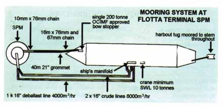
19 MOORING SYSTEM AT FLOTTA TERMINAL JETTY 36 37


20 TERMINAL SERVICES (Further information available in the Talisman s Port Information Booklet) Bunkers and Fresh Water There are no facilities for vessels to either bunker or take on fresh water at the terminal. However, these services can be organised while the vessel is anchored in Flow. Fresh water and gas oil are obtainable locally but fuel oil has to be shipped into the port. Stores Stores may be taken on board at the terminal but not on the ships main cargo deck during cargo operations and not, in any case, without the loading master s prior consent. There are no restrictions relating to storage while anchored in Flow. Garbage Disposal There is a limited service for the disposal of garbage at the terminal. Again, this service may be organised while the vessel is at anchor. Telephone A public telephone for outgoing calls is available to vessels moored at the jetty. The telephone only accepts phonecards which are available from the ship s agent. Medical There is a medic on site at the terminal at all times ready to deal with emergency medical situations. Flotta Oil Terminal GUIDE TO GOOD PRACTICE FOR SMALL VESSEL BUNKERING OPERATIONS Orkney Islands Council Marine Services has produced this guide for small vessel owners and operators. The aim is to highlight the need for safe and environmentally friendly working practices in what is an everyday occurrence in the many piers and harbours operated by Marine Services. The following is a list of recommended procedures to follow during bunkering operations. Ensure the vessel is securely moored in a suitable berth with a safe means of access between the vessel and the shore. Ensure all suitable safety precautions are taken e.g. no smoking, no naked lights and suitable personal protection A suitable fire extinguisher should be to hand in case of emergency. If receiving bunkers from a road tanker, always confirm with the driver the quantity and type of fuel to be taken. Agree communications between the driver and yourself. Disengage any mechanical bilge pumps and switch to manual any automatic electrical bilge pumps. Ensure a suitable size of nozzle is used on the fuel delivery line into the fuel tank. If bunkering using oil drums or other, ensure a suitable size of funnel is used for filling the fuel tank. Have an adequate quantity of absorbent material available for use in the event of any spillage occurring. Once refuelling is complete ensure all tank lids are closed and secured. Wipe up any spillage with absorbent material and clean away any residual oil with suitable detergent. Dispose of any waste material in the appropriate bins and tanks situated around the harbour. Report to pier master and/or Orkney VTS at the start and end of bunkering operations

21 GUIDE TO GOOD PRACTICE FOR THE DISPOSAL OF WASTE MATERIALS There are in place number of regulations where vessels and ports have to provide information, facilities and methods of disposal to ensure all waste is disposed of appropriately. Marine Services provide waste reception facilities to meet the needs of the vessels routinely visiting the numerous piers and harbours under their jurisdiction. Marine Services have produced this guide for all vessel owners and operators. The aim is to highlight the need for environmentally friendly methods of disposal in what is an everyday occurrence in the many piers and harbours operated by Marine Services. Protecting Orkney s marine environment is essential It is in everybody s interest that we all follow these recommended procedures to ensure a safe and environmentally friendly method of disposal. Dispose of waste oils in the oil storage tanks provided. If there is no facility available contact the Piermaster at the location to arrange for the disposal or contact Dispose of all garbage in the waste reception bins provided. Do not place heavy metal or other hazardous waste objects in these bins. Double bag all food waste to prevent leakage. If your vessel has been outside of the European Union ports please contact the Piermaster or contact to arrange for disposal of food wastes. Dispose of larger items, metals, ropes, nets etc in the waste skips provided. If there is no facility is available contact the Piermaster at the location to arrange for the disposal or contact The cost of disposal of garbage is part of the harbour dues charged to port users, when quantities of over 2.0 tonnes or 16.0m 3 is landed an additional charge is applied. Small quantities of waste oils that can be disposed of in reception tanks provided are free of charge but when a reception tank is required a fee is applied. All charges for port waste reception are available in the schedule of charges. The locations of port waste reception facilities can be found in the various plans contained in this port handbook. Fixed Navigation lights Orkney Mainland, North and South Isles Location/name Latitude N Longitude W Character Additional Info North Ronaldsay Dennis Head lighthouse Fl W 10s fl 0.3 racon Nouster Pier Q R Papa Westray Moclett Pier Fl WRG 5s Westray Noup Head lighthouse Fl W 30s Pierowall East Pier Fl WRG 3s Pierowall West Pier F R (vert) Rapness Terminal F R (vert) Eday Calf Sound Fl (3) WRG 10s Backaland Pier Fl R 3s Sanday Loth Terminal F G (vert) Kettletoft Pier Fl WRG 3s Start Point lighthouse Fl (2) W 20s Stronsay & Papa Stronsay Whitehall Pier F G (vert) The Ness lighthouse Fl (4) W 20s Shapinsay & Helliar Holm Balfour Pier Fl (2) WRG 5s Helliar Holm lighthouse Fl WRG 10s Egilsay Egilsay Pier Fl G 3s Auskerry Lighthouse Fl W 20s Copinsay Lighthouse Fl (5) W 30s Thieves Holm Light tower Q R Swona North Head Fl (3) W 10s Selkie Skerry Fl W 8s 40 41
22 Location/name Latitude N Longitude W Character Additional Info South Ronaldsay Burwick Breakwater F R (vert) Hoxa Head Fl WR 3s Needle Point Reef Fl G 3s St Margarets Hope Pier F G (vert) Leading lights front F G 174 deg Leading lights rear F G 174 deg Hoy & South Walls Ruff Reef Fl W 10s Cantick Head lighthouse Fl W 20s Torness Fl W 5s Lyness Golden Wharf F R (vert) Lyness Wharf F R (vert) Longhope Pier Fl WRG 3s Flotta & Calf of Flotta Stanger Head Fl R 5s Sutherland Pier Q G Gibraltar Pier F G (vert) Roan Head Fl (2) R 6s Calf of Flotta Q R Flotta Oil Terminal Flotta Terminal Jetty E F R (vert) Flotta Terminal Jetty W F R (vert) Flotta Terminal dolphins E Q R Flotta Terminal dolphins W Q R Flotta Terminal SPM tower Fl Y 5s Flotta Terminal SPM tower Fl (4) Y 15s Cava Cava lighthouse Fl WR 3s Graemsay Hoy Low lighthouse Iso W 3s Front Hoy High lighthouse Oc WR 8s Rear Graemsay Pier Sector Light F R (vert) North Hoy Moaness Pier Sector Light Dir WRG 173 deg Orkney Mainland Location/name Latitude N Longitude W Character Additional Info Brough of Birsay Lighthouse Fl (3) W 25 s Kirkwall Harbour Kirkwall Pier N End Iso WRG 5s Kirkwall Pier E End F G (vert) Kirkwall Inner Basin F R (vert) Kirkwall West Pier F G (vert) Kirkwall Marina Breakwater F R (vert) Hatston Pier East F G (vert) Hatston Pier West F G (vert) Rose Ness Fl W 6s Pier Fl G 3s Houton Terminal Iso R 4s Pier Head F R Leading lights front Fl G 3s 316 deg Leading lights rear F G 316 deg Houton Marker Post Fl R 3s Stromness Harbour Skerry of Ness Fl WG 4s Pole Star Pier Iso R 6s Leading lights front F R 317 deg Leading lights rear F R 317 deg North Pier Fl R 3s South Pier F R (vert) Marina breakwater Fl (2) R 5s Copland s Dock Pier F G (vert) Tingwall Pier F R (vert) SE Extention FG (vert) Lit Beacons Nevi Skerry Fl (2) W 6s Barrel of Butter Fl (2) W10s Lother Rock Fl W 2s fl 0.6 racon 42 43
23 Navigation Buoys 44 Location/name Latitude N Longitude W Character Additional Info Kirkwall Harbour Holm of Faray Fl (2) R 12s Scargun Shoal Q (3) W E cardinal Linga Skerry Q (3) W 10s E cardinal Boray Skerry Q (6)+LFl W 15s S cardinal Skertours Q W N cardinal Graand Q (6)+LFl W 15s S cardinal Galt Skerry Q W N cardinal Eday Gruna Q W N cardinal Rusk Holm Fl (2) R 6s Rapness Sound Fl (2) R 12s Wyre Skerry Q W 9s W cardinal Stronsay Harbour Quiabow Fl (2) G 12s No 1 buoy Fl G 5s No 2 buoy Fl R 5s No 4 buoy Fl (2) R 5s No 3 buoy Fl (2) G 5s Flow Grinds Fl (2) R 10s Vanguard Wreck VQ (3) W 5s E cardinal PrudentiaWreck Q (3) W 10s E cardinal Royal Oak Wreck Fl (3) G 20s Skerry Fl (2) R 12s Crockness Fl (2) R 12s Gutter Sound Wreck Fl R 6s Bay of Houton Fl G Peter Skerry Fl G 6s Riddock Shoal Fl (2) R 12s Sand Eel Q (3) W 10s E cardinal Barr Rock Q W N cardinal Stromness Harbour Outer Buoy Q R Inner Buoy Fl G 3s Coplands Dock Fl G (2) 5s European Marine Energy Test Site North buoy Q W N cardinal East buoy Q (3) W 10s E cardinal South buoy Q (6)+LFl W 15s S cardinal West buoy Q (9) W 15s W cardinal West buoy (2) W cardinal (2) INDEX TO PIERS & HARBOURS Burray Burwick Backaland - Eday Egilsay Gibraltar - Flotta Sutherland - Flotta Graemsay Holm St Mary s Houton Longhope - Hoy Lyness - Hoy Moaness - Hoy Kirkwall Hatston - Kirkwall Hatston Slipway - Kirkwall Nouster - North Ronaldsay Moclett - Papa Westray Trumland - Rousay Kettletoft - Sanday Loth - Sanday Pier Flow Balfour - Shapinsay Stromness Copland s Dock - Stromness Pole Star Pier - Stromness Stronsay Whitehall - Stronsay Tingwall Pierowall - Westray Rapness - Westray Wyre Marinas Tidal Atlas Pollution Prevention
24 MAIN PIERS DATA PIER BERTH NUMBER/NAME QUAY LENGTH DRAFT AT CHART DATUM HEAVY LIFT CAPACITIES Concentrated Load Distributed load HATSTON PIER 1A 225 m m 50KN/sq.m 1B 160 m m 1250KN on 1m x 1m 50KN/sq.m 2A 103 m m 50KN/sq.m 2B 126 m m 50KN/sq.m m m 50KN/sq.m Ro-Ro 158 m m 50KN/sq.m Finger Pier 61 m 7.5 m New extension 100KN/sq.m KIRKWALL PIER East Pier sections m m 20KN/sq.m East Fishing berth 82 m m 20KN/sq.m Fishing berths 99 m m 20KN/sq.m North 1 and m m 20KN/sq.m Tanker Berth 119 m m 20KN/sq.m Ro - Ro Berth 82 m m 20KN/sq.m Layby berth 67 m m 20KN/sq.m Basin Harbour Street 284 m m STROMNESS PIER South Pier Inner 71 m and 51 m m 20KN/sq.m South Pier Outer 135 m m 20KN/sq.m South Pier dog leg outer 28 m m 20KN/sq.m North Pier Inner 140 m m 20KN/sq.m Northlink Berth 131 m m 20KN/sq.m Northlink Berth from linkspan 126 m m Marina Finger Pier south 105 m m 20KN/sq.m Marina Finger Pier north 101 m dredged to 3.5 m Middle Pier Inner 44 m m 20KN/sq.m Middle Pier Outer 48 m m 20KN/sq.m Inner Basin North 71 m m 20KN/sq.m Outer Basin South 28 m m 20KN/sq.m COPLANDS DOCK Pier 1 West 100 m m 1000KN on 1m x 1m 50KN/sq.m Pier 2 East m m 1000KN on 1m x 1m 50KN/sq.m Pier 3 South m m 1000KN on 1m x 1m 50KN/sq.m Pier 4 North 98 m m 1000KN on 1m x 1m 50KN/sq.m LYNESS HOY Ro - Ro 66 m m Lyness Wharf 122 m m Golden Wharf 171 m m Lyness Creek m m Heavy lift Area 1500KN on 1m x 1m 50KN/sq.m 46 47
1856 873636 Email: harbours@orkney.gov.uk Website: www.orkneyharbours.com 58 50.60 N 02 54.")

25 BURRAY PIER BURRAY PIER Harbour Office contact details Latitude and longitude of harbour entrance Admiralty chart numbers Water Depth (Below Chart Datum) 3-4m Orkney Islands Council Marine Services Harbour Authority Building Orkney, KW15 1SD Telephone: +44 (0) Website: N W Tel: Fax: Cargo handling: Conventional. The slipway adjacent to the pier is a private facility and not for public use. Fresh water is available via 25mm hose. Pier is of sheet pile and concrete construction. Toilet facilities are available at the head of the pier. Electricity is available on the pier. There is a mooring for visiting yachts up to 18 tonnes in position N W The mooring is only in place between April and October. Maximum available length* Maximum beam* Environmental sensitivities Tugs SSSI/SPA Pentland Firth Islands. For full designations see: Pilotage Berths For berth availability contact Orkney VTS on VHF Ch11/16. Repair facilities i.e. dry docks and slipways Cargo handling facilities i.e. bulk, fuel, containers Local authority Hazards pipelines, overhead cables Orkney Islands Council Tidal range ISPS compliant 4m No *Larger vessels may be accepted on a case by case basis at the sole discretion of the harbour master 48 49
1856 873636 Email: harbours@orkney.gov.uk Website: www.orkneyharbours.com 58 44.40`N 02 57.")
26 BURWICK - SOUTH RONALDSAY BURWICK - SOUTH RONALDSAY Harbour Office contact details Latitude and longitude of harbour entrance Admiralty chart numbers Water Depth (Below Chart Datum) 3-4m Orkney Islands Council Marine Services Harbour Authority Building Orkney, KW15 1SD Telephone: +44 (0) harbours@orkney.gov.uk Website: `N `W Tel: No cargo handling facilities exist here. There is a floating link span that has a barge moored on the end during the summer months. Fresh water is available via 25mm hose. During the summer the berth is used by the passenger ferry from John O Groats. Buses connect with the ferry for transport to/from Kirkwall. For ferry time table see: or the Orkney Islands Council website: Maximum available length* Maximum beam* Environmental sensitivities Tugs SSSI/SPA Pentland Firth Islands. For full designations see: Pilotage Berths For berth availability contact Orkney VTS on VHF Ch11/16. Repair facilities i.e. dry docks and slipways Cargo handling facilities i.e. bulk, fuel, containers Local authority Hazards pipelines, overhead cables Orkney Islands Council Tidal range ISPS compliant 4m No *Larger vessels may be accepted on a case by case basis at the sole discretion of the harbour master 50 51
1856 873636 Email: harbours@orkney.gov.uk Website: www.orkneyharbours.com 59 09.40 N 02 44.")
27 BACKALAND PIER - EDAY BACKALAND PIER - EDAY Harbour Office contact details Latitude and longitude of harbour entrance Admiralty chart numbers Water Depth (Below Chart Datum) 5-7m Orkney Islands Council Marine Services Harbour Authority Building Orkney, KW15 1SD Telephone: +44 (0) harbours@orkney.gov.uk Website: N W Tel: For berth availability call Eday Pier on VHF CH 16/12. Cargo Handling: Ro-Ro and Conventional Local ferry uses the Ro-Ro berth and has priority. For ferry time table see Fresh water via 25mm hose. The slipway facility is available for public use. There is a waiting room with telephone and toilets at the top of the pier. There is a mooring for visiting vessels in Calf Sound at N W The mooring is only in place between April and October. Maximum available length* Maximum beam* Lock dimensions Environmental sensitivities Tugs 50m SPA Calf of Eday. For full designations see: Contact VTS. Pilotage Berths For berth availability contact Orkney VTS on VHF Ch11/16. Repair facilities i.e. dry docks and slipways Cargo handling facilities i.e. bulk, fuel, Ro-Ro and conventional containers Local authority Hazards pipelines, overhead cables Orkney Islands Council Tidal range ISPS compliant 4m No *Larger vessels may be accepted on a case by case basis at the sole discretion of the harbour master 52 53
1856 873636 Email: harbours@orkney.gov.uk Website: www.orkneyharbours.com 59 09.30 N 02 56.")
28 EGILSAY PIER EGILSAY PIER Harbour Office contact details Latitude and longitude of harbour entrance Admiralty chart numbers 2249/2250 Water Depth (Below Chart Datum) 1-2m Orkney Islands Council Marine Services Harbour Authority Building Orkney, KW15 1SD Telephone: +44 (0) Website: N W Tel: Cargo handling: Ro-Ro Fresh water via 25mm hose. For berth availability call piermaster by telephone. Local Ferry uses the pier and has priority. For ferry time table see There is a waiting room with telephone and toilets at the top of the pier. Maximum available length* Maximum beam* Lock dimensions Environmental sensitivities Tugs 28m SPA Rousay. Wyre & Rousay Sounds MPA. For full designations see: Pilotage Berths For berth availability contact Orkney VTS on VHF Ch11/16. Repair facilities i.e. dry docks and slipways Cargo handling facilities i.e. bulk, fuel, Hard Ramp containers Local authority Hazards pipelines, overhead cables Orkney Islands Council Tidal range ISPS compliant ISPS compliant 4m No No *Larger vessels may be accepted on a case by case basis at the sole discretion of the harbour master 54 55
1856 873636 Email: harbours@orkney.gov.uk Website: www.orkneyharbours.com 58 50.30 N 03 07.")
29 GIBRALTAR PIER - FLOTTA GIBRALTAR PIER - FLOTTA Harbour Office contact details Latitude and longitude of harbour entrance Admiralty chart numbers Water Depth (Below Chart Datum) 2-3m Orkney Islands Council Marine Services Harbour Authority Building Orkney, KW15 1SD Telephone: +44 (0) harbours@orkney.gov.uk Website: N W Tel: For berth availability call Orkney VTS on VHF Ch 16/11. Cargo Handling: Conventional /Ro-Ro Fresh water is available via 25mm hose. Pier is of sheet pile and concrete construction with limited fendering. A waiting room and toilets are available at the head of the pier. The local ferry uses the Ro-Ro berth. For ferry time table see Maximum available length* Maximum beam* Lock dimensions Environmental sensitivities Tugs 53m For full designations see: Pilotage Berths For berth availability contact Orkney VTS on VHF Ch11/16. Repair facilities i.e. dry docks and slipways Cargo handling facilities i.e. bulk, fuel, Conventional/ Ro-Ro containers Local authority Hazards pipelines, overhead cables Orkney Islands Council Tidal range ISPS compliant 4m No *Larger vessels may be accepted on a case by case basis at the sole discretion of the harbour master 56 57
1856 873636 Email: harbours@orkney.gov.uk Website: www.orkneyharbours.com 58 50.20 N 03 07.")
30 SUTHERLAND PIER - FLOTTA SUTHERLAND PIER - FLOTTA Harbour Office contact details Latitude and longitude of harbour entrance Admiralty chart numbers Water Depth (Below Chart Datum) 3-5m Orkney Islands Council Marine Services Harbour Authority Building Orkney, KW15 1SD Telephone: +44 (0) harbours@orkney.gov.uk Website: N W Tel: Cargo handling: Conventional. For berth availability call Orkney VTS VHF Ch 16/11. Fresh water is available via 25mm hose. The pier is of sheet pile and concrete construction with limited fendering available. This pier is used mainly by the tugs and work boats that serve the Flotta Oil Terminal. Maximum available length* Maximum beam* Environmental sensitivities Tugs 100m For full designations see: Pilotage Berths For berth availability contact Orkney VTS on VHF Ch11/16. Repair facilities i.e. dry docks and slipways Cargo handling facilities i.e. bulk, fuel, Conventional containers Local authority Hazards pipelines, overhead cables Orkney Islands Council Tidal range ISPS compliant 4m No *Larger vessels may be accepted on a case by case basis at the sole discretion of the harbour master 58 59
1856 873636 Email: harbours@orkney.gov.uk Website: www.orkneyharbours.com 58 55.90 N 03 15.")

31 GRAEMSAY PIER GRAEMSAY PIER Harbour Office contact details Latitude and longitude of harbour entrance Admiralty chart numbers Water Depth (Below Chart Datum) 2-5m Orkney Islands Council Marine Services Harbour Authority Building Orkney, KW15 1SD Telephone: +44 (0) Website: N W Tel: For berth availability call Orkney VTS on VHF Ch 16/11. Cargo Handling: conventional Fresh water is available through a 25mm hose. There are toilets and a waiting room at the head of the pier. Pier is of sheet pile and concrete construction with diagonal rubber fendering. Local Ferry uses the pier regularly and has priority for the outermost set of steps. For ferry time table see Maximum available length* Maximum beam* Lock dimensions Environmental sensitivities Tugs Pilotage Berths Repair facilities i.e. dry docks and slipways Cargo handling facilities i.e. bulk, fuel, containers Local authority 20m SPA Hoy Natural Scenic Area Hoy and West Mainland For full designations see: For berth availability contact Orkney VTS on VHF Ch11/16. Conventional Orkney Islands Council Hazards pipelines, overhead cables Tidal range ISPS compliant 4m No *Larger vessels may be accepted on a case by case basis at the sole discretion of the harbour master 60 61
1856 873636 Email: harbours@orkney.gov.uk Website: www.orkneyharbours.com 58 53.80 N 02 54.")
32 HOLM PIER - ST MARY S HOLM PIER - ST MARY S Harbour Office contact details Latitude and longitude of harbour entrance Admiralty chart numbers Water Depth (Below Chart Datum) 1-3m Orkney Islands Council Marine Services Harbour Authority Building Orkney, KW15 1SD Telephone: +44 (0) harbours@orkney.gov.uk Website: N W Tel: For berth availability call Orkney VTS on VHF Ch 16/11. Cargo handling: Conventional Fresh water is available via 25mm hose. Pier is of concrete construction with very little fendering. There is a mooring for visiting vessels up to 18 tonnes in position N W The mooring is only in place from April to October. The pier is home to the Holm Sailing Club. Maximum available length* Maximum beam* Lock dimensions Environmental sensitivities Tugs 30m For full designations see: Pilotage Berths For berth availability contact Orkney VTS on VHF Ch11/16. Repair facilities i.e. dry docks and slipways Small boat slipway Cargo handling facilities i.e. bulk, fuel, Conventional containers Local authority Hazards pipelines, overhead cables Orkney Islands Council Tidal range ISPS compliant 4m No *Larger vessels may be accepted on a case by case basis at the sole discretion of the harbour master 62 63
1856 873636 Email: harbours@orkney.gov.uk Website: www.orkneyharbours.com 58 55.10 N 03 11.")

33 HOUTON TERMINAL - ORPHIR HOUTON TERMINAL - ORPHIR Harbour Office contact details Latitude and longitude of harbour entrance Admiralty chart numbers Water Depth (Below Chart Datum) 1-3m Orkney Islands Council Marine Services Harbour Authority Building Orkney, KW15 1SD Telephone: +44 (0) harbours@orkney.gov.uk Website: N W Tel: Cargo Handling: Ro-Ro. No fresh water available. Pier is of sheet pile construction with limited fendering. Toilets and waiting room are available at the top of the pier. This is the ferry terminal that serves Lyness and Flotta. For ferry time table see The North Pier is for the private use of Flotta Terminal. Maximum available length* Maximum beam* Environmental sensitivities Tugs 53m SPA Hoy Natural Scenic Areas Hoy and West Mainland For full designations see: Pilotage Contact Orkney VTS on VHS channel 11/16 Berths Repair facilities i.e. dry docks and slipways Cargo handling facilities i.e. bulk, fuel, containers Local authority Hazards pipelines, overhead cables This is the ferry terminal that serves Lyness and Flotta. Ro - Ro Linkspan Orkney Islands Council Tidal range ISPS compliant 4m No *Larger vessels may be accepted on a case by case basis at the sole discretion of the harbour master 64 65
1856 873636 Email:")
34 LONGHOPE PIER - HOY LONGHOPE PIER - HOY Harbour Office contact details Latitude and longitude of harbour entrance Admiralty chart numbers Water Depth (Below Chart Datum) 2-5m Maximum available length* Maximum beam* Lock dimensions Environmental sensitivities Tugs Pilotage Orkney Islands Council Marine Services Harbour Authority Building Orkney, KW15 1SD Telephone: +44 (0) harbours@orkney.gov.uk Website: N W 53m For full designations see: Berths For berth availability contact Orkney VTS on VHF Ch11/16. Repair facilities i.e. dry docks and slipways Small boat slipway Cargo handling facilities i.e. bulk, fuel, Conventional containers Local authority Hazards pipelines, overhead cables Orkney Islands Council Tel: For berth availability call Orkney VTS on VHF Ch16/11. Cargo Handling: Conventional Fresh water is available via 25mm hose. Pier is of sheet pile construction with limited fendering. Two yacht mooring buoys lie close to the pier for yachts up to 18 tonnes. In positions: N W N W The moorings are only in place between April and October. Toilets and shower facilities are located at the head of the pier. Fuel and groceries are available from the shop at the top of the pier as is the local post office. Fuel is also available for members of the Orkney Marine Fuel Co., from a bunded tank located on the pier. Longhope Lifeboat is stationed at the pier on its own berthing pontoon. The local ferry berths at the pier overnight. Tidal range ISPS compliant 4m No *Larger vessels may be accepted on a case by case basis at the sole discretion of the harbour master 66 67
1856 873636 Email:")
35 LYNESS PIER - HOY LYNESS PIER - HOY Harbour Office contact details Latitude and longitude of harbour entrance Admiralty chart numbers Water Depth (Below Chart Datum) 4-8m Maximum available length* Maximum beam* Lock dimensions Environmental sensitivities Tugs Pilotage Orkney Islands Council Marine Services Harbour Authority Building Orkney, KW15 1SD Telephone: +44 (0) harbours@orkney.gov.uk Website: N W 170m No limit For full designations see: For Tug availability contact Orkney VTS on VHF Ch11/16. Pilotage on request Berths For berth availability contact Orkney VTS on VHF Ch11/16. Repair facilities i.e. dry docks and slipways Cargo handling facilities i.e. bulk, fuel, Conventional/ Ro-Ro Linkspan containers Local authority Hazards pipelines, overhead cables Orkney islands Council Tel: For berth availability call Lyness pier on VHF CH 12 or Orkney VTS on VHF CH 16/11 Cargo handling: Conventional /Ro-Ro The pier is of large concrete block construction, and recently refurbished in Numerous dive boats and the local fish farm boats use this pier. Shore side facilities include Yokohama fendering, quayside hard standing, lighting, shore power and fresh water. Fresh water is available via 25mm hose. A 200 tonne fresh water storage tank is now installed, however a filtration system is yet to be implemented for potable water. The local ferry uses the Ro-Ro berth. For ferry time table see There are toilets and waiting room close to the Ro-Ro berth. During the summer months a café is available in the interpretation centre a short walk from the pier. Tidal range ISPS compliant 4m No *Larger vessels may be accepted on a case by case basis at the sole discretion of the harbour master 68 69

36 Hoy - Lyness Development Plan & Enterprise Area 70 71
1856 873636 Email: harbours@orkney.gov.uk Website: www.orkneyharbours.com 58 55.00 N 03 18.")

37 MOANESS PIER - HOY MOANESS PIER - HOY Harbour Office contact details Latitude and longitude of harbour entrance Admiralty chart numbers Water Depth (Below Chart Datum) 1-2m Orkney Islands Council Marine Services Harbour Authority Building Orkney, KW15 1SD Telephone: +44 (0) harbours@orkney.gov.uk Website: N W Tel: Cargo handling: Conventional. For berth availability call Orkney VTS on VHF CH 16/11. Pier is of concrete consturction with limited fendering. There are toilets and waiting room at the head of the pier. The local ferry uses the pier regularly and it has priority on the steps. For ferry timetable see: Maximum available length* Maximum beam* Environmental sensitivities Tugs Pilotage Berths Repair facilities i.e. dry docks and slipways Cargo handling facilities i.e. bulk, fuel, containers Local authority 20m SPA Hoy National Scenic Area Hoy and West Mainland For full designations see: For berth availability contact Orkney VTS on VHF Ch11/16. Conventional Orkney Islands Council Hazards pipelines, overhead cables Tidal range ISPS compliant 4m No *Larger vessels may be accepted on a case by case basis at the sole discretion of the harbour master 72 73
38 KIRKWALL PIER KIRKWALL & HATSTON Oil Loading Store Harbour Office Ferry Terminal Office Linkspan Hard Ramp North Pier Store RNLI West Pier Store Lifeboat Berth The Basin Slipway Cattle Shed/Store Lorry Parking Wash Bay Marina Showers Lorry Parking Weigh Bridge Orkney Ferries Offices Toilets Marina Pontoons Marina Pontoons Breakwater Pier Mud Mud 240v Electrical Point 415v Electrical Point Mud Pre-arrival Vessels requiring a pilot should give 12 and 2 hours notice prior to arrival. All other vessels over 12 metres in length or certified to carry 12 passenger or more, should give 2 hours notice prior to arrival at the harbour limits (see VTS ). Approach and Navigation Reference documents include: Charts: BA 2584 and North coast of Scotland Pilot NP52. Admiralty Tidal Atlas NP209. On approaching Kirkwall Bay, vessels over 12 metres in length or certified to carry more than 12 persons, should contact Kirkwall Harbour on VHF Ch.14. While in the port, these vessels should also advise Kirkwall Harbour when they are securely moored and just prior to any movement they are about to make in the port. Anchorages During foul weather, vessels can anchor in the Bay of Isbister or north Shapinsay Sound in strong northerlies, or Inganess Bay or Kirkwall Bay in southerlies. Swept anchorages in Kirkwall Bay are ½ mile and 1 mile north of Kirkwall pier. Pilots Service operates 24hrs. Pilotage is compulsory for passenger vessels over 65 metres and all other vessels over 80 metres in length. All vessels under tow where the length of tow is over 65 meters and all vessels over 300gt carrying persistent oils in bulk must carry a pilot. Vessels requiring or requesting a pilot must provide a minimum of 2hrs notice to Orkney VTS. Arrival A pilot launch is on station, listening on VHF Ch.11 when a vessel is expected. Call Kirkwall Pilots. Pilot launch: 12knots. Boarding speed: as requested by launch coxswain. Departure Vessels requiring a pilot for departure should give at least 2 hours notice. Tugs The pilot launch Kirkwall Bay is normally available for towage duty. See section on Harbour Craft. Berths See chartlets on pages 66 and 113 for details. Kirkwall Services Bunkers Gas oil is available from road tankers. There is no local supply of fuel oil. Fresh Water Fresh water is available for vessels berthed alongside. A 100 ton tank will be installed at Hatston Pier in Stores There are no restrictions to vessels taking on stores in the port. There are three supermarkets and numerous smaller shops in the town. Cranes Cranes are available by arrangement with local contractors. Garbage Disposal Garbage may be landed. Euro bins, a skip and an oil collection tank is provided. Charges may apply. Medical The town has full medical and dental facilities

39 76 77
40 KIRKWALL PIER HATSTON PIER Harbour Office contact details Latitude and longitude of harbour entrance Admiralty chart numbers Orkney Islands Council Marine Services Harbour Authority Building Orkney, KW15 1SD Telephone: +44 (0) Website: N W Harbour Office contact details Latitude and longitude of harbour entrance Admiralty chart numbers Orkney Islands Council Marine Services Harbour Authority Building Orkney, KW15 1SD Telephone: +44 (0) harbours@orkney.gov.uk Website: N W Water Depth (Below Chart Datum) 1-5.5m Water Depth (Below Chart Datum) m Maximum available length* 119m Maximum available length* 385m Maximum beam* Maximum beam* No restraint Lock dimensions Environmental sensitivities Tugs Pilotage Berths For full designations see: Available Kirkwall Harbour Radio VHF channel 14 or contact Orkney VTS on VHF Ch11/16. Available Repair facilities i.e. dry docks and There is a boat slip at Hatston slipways Cargo handling facilities i.e. bulk, fuel, Fuel Gantry; bulk loading and Lo-Lo contingency containers Local authority Hazards pipelines, overhead cables Tidal range ISPS compliant Orkney Islands Council 4m Yes *Larger vessels may be accepted on a case by case basis at the sole discretion of the harbour master Lock dimensions Environmental sensitivities Tugs For full designations see: May be available from Flow Pilotage For berth availability contact Orkney VTS on VHF Ch11/16 Berths 1A=225m, 1B=160m, 2A=103m, 2b=124m, 3=115m, Ro Ro=157m Repair facilities i.e. dry docks and slipways Boat slip Cargo handling facilities i.e. bulk, fuel, Bulk and Lo-Lo and linkspan containers Local authority Hazards pipelines, overhead cables Tidal range ISPS compliant Orkney Island Council 4m Yes *Larger vessels may be accepted on a case by case basis at the sole discretion of the harbour master 78 79

41 HATSTON - KIRKWALL 80 81


42 HATSTON DEVELOPMENT & ENTERPRISE AREA - KIRKWALL Enterprise Areas: Hatston and Lyness have between them 16.9 hectares of designated Enterprise Area status by the Scottish Government. The designation is for an initial 5 year period commencing April 2012 and includes: Business Rates Discounts Enhanced Capital Allowances for investment in plant and machinery A streamlined approach to planning High speed broadband connections International promotion and marketing of Enterprise Areas Skills and training support to fully capitalise on the employment opportunities created For further information on Enterprise Areas please contact stuart.allison@orkney.gov.uk 2b 1b 2a 3 1a Ro-Ro Quay edge Draft Hatston 1a 225m 10m to 10.5m Hatston 1b 160m 10m to 10.5m Hatston 2a 103m 5m to 8m Hatston 2b 124m 8m to 8.5m Hatston 3 115m 3.5m to 7m Ro-Ro berth 157m 8.5m to 9m Enterprise Area: 10 hectares Total Area: 11 hectares OS Grid Ref. - HY Scale: 1:4,
1856 873636 Email: harbours@orkney.gov.uk Website: www.orkneyharbours.com 58 59.40 N 02 58.")
43 HATSTON SLIPWAY - KIRKWALL HATSTON SLIPWAY - KIRKWALL Harbour Office contact details Latitude and longitude of harbour entrance Admiralty chart numbers Orkney Islands Council Marine Services Harbour Authority Building Orkney, KW15 1SD Telephone: +44 (0) harbours@orkney.gov.uk Website: N W Tel: / Launching and drying out facilities available with the permission of the piermaster. Contact Piermaster on by telephone or VHF ch 14. Crane required for drying out facilities. Water Depth (Below Chart Datum) Maximum available length* Maximum beam* Environmental sensitivities Tugs Pilotage Berths Repair facilities i.e. dry docks and slipways Cargo handling facilities i.e. bulk, fuel, containers Local authority Hazards pipelines, overhead cables Tidal range ISPS compliant ISPS compliant 0.74m at toe. For full designations see: Slipway Orkney Islands Council Creel buoys on approach 4m No Yes *Larger vessels may be accepted on a case by case basis at the sole discretion of the harbour master 84 85
1856 873636 Email: harbours@orkney.gov.uk Website: www.orkneyharbours.com 59 21.24 N 02 26.")
44 NOUSTER PIER - NORTH RONALDSAY NOUSTER PIER - NORTH RONALDSAY Harbour Office contact details Latitude and longitude of harbour entrance Admiralty chart numbers Water Depth (Below Chart Datum) 1-3m Orkney Islands Council Marine Services Harbour Authority Building Orkney, KW15 1SD Telephone: +44 (0) harbours@orkney.gov.uk Website: N W Tel : For berth availability call Orkney VTS on VHF CH 16/11. Cargo Handling: Conventional Lo-Lo Local ferry uses the pier weekly and has priority for the outermost set of steps. Fresh water via 25mm hose. For ferry time table see Waiting room with toilets at the top of the pier. There are two moorings for visiting vessels up to 18 tonnes at positions N W. The moorings are in place between April and October. Maximum available length* Maximum beam* Lock dimensions Environmental sensitivities Tugs 50m SPC Sanday. For full designations see: Pilotage Berths For berth availability contact Orkney VTS on VHF Ch11/16. Repair facilities i.e. dry docks and slipways Cargo handling facilities i.e. bulk, fuel, Conventional containers Local authority Hazards pipelines, overhead cables Orkney Islands Council Tidal range ISPS compliant 4m No *Larger vessels may be accepted on a case by case basis at the sole discretion of the harbour master 86 87
1856 873636 Email: harbours@orkney.gov.uk Website: www.orkneyharbours.com 59 19.60 N 02 53.")
45 MOCLETT PIER - PAPA WESTRAY MOCLETT PIER - PAPA WESTRAY Harbour Office contact details Latitude and longitude of harbour entrance Admiralty chart numbers 2249/2250 Water Depth (Below Chart Datum) 1-3m Orkney Islands Council Marine Services Harbour Authority Building Orkney, KW15 1SD Telephone: +44 (0) harbours@orkney.gov.uk Website: N W Tel: For berth availability call Orkney VTS on VHF CH 16/11. Cargo Handling: Conventional Fresh water via 25mm hose. Local ferry (to Westray) uses the pier and has priority for the outermost set of steps. There is a waiting room and toilets at the head of the pier. For ferry time table see There is a mooring buoy for visiting vessels up to 18 tonnes in position N W, The mooring is in place between April and October. Maximum available length* Maximum beam* Lock dimensions Environmental sensitivities Tugs 50m SSSI Holm of Papa Westray SPA Papa Westray (North Hill and Holm) For full designations see: Pilotage Berths For berth availability contact Orkney VTS on VHF Ch11/16. Repair facilities i.e. dry docks and slipways Cargo handling facilities i.e. bulk, fuel, Conventional Lo-Lo containers Local authority Hazards pipelines, overhead cables Orkney Islands Council Tidal range ISPS compliant 4m No *Larger vessels may be accepted on a case by case basis at the sole discretion of the harbour master 88 89
1856 873636 Email: harbours@orkney.gov.uk Website: www.orkneyharbours.com 59 07.")
46 TRUMLAND PIER - ROUSAY TRUMLAND PIER - ROUSAY Harbour Office contact details Latitude and longitude of harbour entrance Admiralty chart numbers 2249/2250 Water Depth (Below Chart Datum) 1-4m Maximum available length* Orkney Islands Council Marine Services Harbour Authority Building Orkney, KW15 1SD Telephone: +44 (0) harbours@orkney.gov.uk Website: N W 28m Tel: For berth availability call Orkney VTS on VHF CH 16/11. Cargo Handling: Ro-Ro and Conventional Local Ferry uses the hard ramp berth and has priority. The ferry berths here overnight. For ferry time table see There is a waiting room with toilets at the top of the pier. There is fuel and a shop next to the pier, a hotel approximately 1 km to the west. Fresh water via 25mm hose. There is a mooring for visiting vessels up to 18 tonnes in position N, W The mooring is only in place beween April and October. Maximum beam* Lock dimensions Environmental sensitivities Tugs SPA/SSSI Rousay SSSI Eynhallow Wyre & Rousay Sounds MPA For full designations see: Pilotage Berths For berth availability contact Orkney VTS on VHF Ch11/16. Repair facilities i.e. dry docks and slipways Ferry slip Cargo handling facilities i.e. bulk, fuel, Hard Ramp and Conventional containers Local authority Hazards pipelines, overhead cables Orkney Islands Council Tidal range ISPS compliant 4m No *Larger vessels may be accepted on a case by case basis at the sole discretion of the harbour master 90 91
1856 873636 Email: harbours@orkney.gov.uk Website: www.orkneyharbours.com 59 13.90 N 02 35.")
47 KETTLETOFT - SANDAY KETTLETOFT - SANDAY Harbour Office contact details Latitude and longitude of harbour entrance Admiralty chart numbers Water Depth (Below Chart Datum) 1-2m Orkney Islands Council Marine Services Harbour Authority Building Orkney, KW15 1SD Telephone: +44 (0) harbours@orkney.gov.uk Website: N W Tel: For berth availability call Orkney VTS on VHF ch 16/11. Cargo Handling: Conventional Fresh water via 25mm hose. There are toilets on the pier, with fuel, a shop and two hotels next to the pier. Maximum available length* Maximum beam* Lock dimensions Environmental sensitivities Tugs 50m SAC Sanday SSSI/SPA/Ramsar East Sanday Coast. For full designations see: Pilotage Berths For berth availability contact Orkney VTS on VHF Ch11/16. Repair facilities i.e. dry docks and slipways Cargo handling facilities i.e. bulk, fuel, Conventional containers Local authority Hazards pipelines, overhead cables Orkney Islands Council Tidal range ISPS compliant 4m No *Larger vessels may be accepted on a case by case basis at the sole discretion of the harbour master 92 93
1856 873636 Email: harbours@orkney.gov.uk Website: www.orkneyharbours.com 59 11.50 N 02 41.")
48 LOTH PIER - SANDAY LOTH PIER - SANDAY Harbour Office contact details Latitude and longitude of harbour entrance Admiralty chart numbers Water Depth (Below Chart Datum) 3-7m Orkney Islands Council Marine Services Harbour Authority Building Orkney, KW15 1SD Telephone: +44 (0) harbours@orkney.gov.uk Website: N W Tel: For berth availability call Orkney VTS on VHF ch 16/11. Cargo Handling: Ro-Ro and Conventional Local ferry uses the pier and has priority. Fresh water via 25mm hose. For ferry time table see Waiting room telephone and toilets at the top of the pier. For members of the Orkney Marine Fuel Co., marine diesel is available from a bunded tank located on the pier. Maximum available length* Maximum beam* Lock dimensions Environmental sensitivities Tugs 50m SPA Calf of Eday. For full designations see: Pilotage Berths For berth availability contact Orkney VTS on VHF Ch11/16. Repair facilities i.e. dry docks and slipways Cargo handling facilities i.e. bulk, fuel, Ro-Ro and Conventional Linkspan containers Local authority Hazards pipelines, overhead cables Orkney Islands Council Tidal range ISPS compliant 4m No *Larger vessels may be accepted on a case by case basis at the sole discretion of the harbour master 94 95
1856 873636 Email: harbours@orkney.gov.uk Website: www.orkneyharbours.com 58 57.40 N 02 58.")

49 SCAPA PIER SCAPA PIER Harbour Office contact details Latitude and longitude of harbour entrance Admiralty chart numbers 35-0 Water Depth (Below Chart Datum) 3-6m Maximum available length* Maximum beam* Orkney Islands Council Marine Services Harbour Authority Building Orkney, KW15 1SD Telephone: +44 (0) Website: N W 80m Tel: / For berthing information call Orkney VTS on VHF CH 16/11. Cargo handling: Conventional and oil pipeline Electricity available. Fresh water available from a mains hydrant Pier recently widened and includes an area of hard standing and a slipway providing launching facilities at the shoreward end of the north side. Pier is of sheet pile construction. Pier is the main base for Pilot boats, tugs and agents craft servicing the oil port of Flow. It is also the import route for general fuels into Orkney. No berths on inner south side. There is a mooring for visiting vessels up to 18 tonnes in position N W The mooring is only in place between April and October. Lock dimensions Environmental sensitivities Tugs For full designations see: Available Pilotage Available Berths For berth availability contact Orkney VTS on VHF Ch11/16. Repair facilities i.e. dry docks and slipways Boat slip Cargo handling facilities i.e. bulk, fuel, Conventional and Oil Pipeline containers Local authority Hazards pipelines, overhead cables Orkney Islands Council Tidal range ISPS compliant 4m No *Larger vessels may be accepted on a case by case basis at the sole discretion of the harbour master 96 97
50 Flow Flow STROMNESS Moaness Hoy Lyness Finstown Amenity Slip Houton Longhope Flotta Hatston Pier & Terminal Hatston Slip Flow KIRKWALL St Mary s St Margaret s Hope South Ronaldsay Burwick Balfour Burray Pre arrival Tankers visiting Flow should report their ETA to Orkney VTS 24, 12 and 2 hours prior to arrival at the harbour limits. Other vessels requiring a pilot to give 12 and 2 hours notice. All vessels over 20 metres should give 2 hours notice. (See VTS page 8) Approach & Navigation Reference documents include: Charts: BA 2162, 2581 and 35. North Coast of Scotland Pilot NP52. Admiralty Tidal Atlas NP209. Note: - The principle entrance to Flow is from the south via the Pentland Firth. This stretch of water contains some of the strongest tidal flows in the world and it is therefore imperative that mariners study the contents of the relative documents and charts relating to navigational recommendations and tidal flows for this area before approaching the harbour limits. A detailed voyage plan is essential. While in the port, the vessel s VHF radio should be set to channel 11 and, where applicable, to the appropriate channel for the intended destination (see appendix). Listen out for traffic information. Ships navigating in the port should do so with caution, paying particular attention to tide flows and the traffic situation. Recommended tracks should be used for guidance. Note:- Orkney VTS has radar coverage over the Pentland Firth/ Flow areas. Tugs Certain vessels are required to be accompanied by a tug escort while navigating this area. See section entitled Towage for details. Pilots Service operates 24hrs. Pilotage is compulsory for passenger vessels over 65 metres and all other vessels over 80 metres in length. All vessels under tow where length of tow is over 65 meters; All vessels over 300gt carrying persistent oils in bulk. Vessels requiring or requesting a pilot must provide a minimum of 2hrs notice to Orkney VTS. Arrival The Pentland Firth west pilot station is the preferred boarding area as it affords more sea room and has a more predictable tide flow. A pilot launch is on station, listening on VHF Ch.11, when a vessel is expected. Call: SCAPA FLOW PILOTS Pilot Launch: 13/20 knots. Boarding Speed: As requested by launch coxswain. Departure Vessels requiring a pilot for departure should give at least 2 hours notice. The pilot will normally disembark between Nevi Skerry and Stanger Head to allow the vessel to build up to full speed prior to entering the tidal flow in the Pentland Firth. Anchoring Flow offers a spacious, secure anchorage with good shelter from foul weather. Vessels should anchor as directed by the harbour authority
51 BALFOUR PIER - SHAPINSAY BALFOUR PIER - SHAPINSAY Harbour Office contact details Latitude and longitude of harbour entrance Admiralty chart numbers Water Depth (Below Chart Datum) 2-4m Orkney Islands Council Marine Services Harbour Authority Building Orkney, KW15 1SD Telephone: +44 (0) harbours@orkney.gov.uk Website: N W Tel: For berth availability call Orkney VTS on VHF CH 16/11. Cargo Handling: Ro-Ro and Conventional. Electricity (240v) is available. Fresh water is available. Balfour village, with shops, fuel and a hotel, is close to the pier. There are two mooring buoys for visiting vessels up to 18 tonnes in positions N, W N, W The moorings are in place between April and October. Maximum available length* Maximum beam* Lock dimensions Environmental sensitivities Tugs 33m For full designations see: Pilotage Berths For berth availability contact Orkney VTS on VHF Ch11/16. Repair facilities i.e. dry docks and slipways Cargo handling facilities i.e. bulk, fuel, Hard Ramp and Conventional containers Local authority Hazards pipelines, overhead cables Orkney Islands Council Tidal range ISPS compliant 4m No *Larger vessels may be accepted on a case by case basis at the sole discretion of the harbour master
52 STROMNESS PIER STROMNESS PIER 102 Harbour Office contact details Latitude and longitude of harbour entrance Admiralty chart numbers Water Depth (Below Chart Datum) 3-6m Maximum available length* Maximum beam* Lock dimensions Environmental sensitivities Tugs Pilotage Berths Orkney Islands Council Marine Services Harbour Authority Building Orkney, KW15 1SD Telephone: +44 (0) Website: N W 135m Repair facilities i.e. dry docks and slipways Cargo handling facilities i.e. bulk, fuel, containers Local authority Hazards pipelines, overhead cables Tidal range ISPS compliant SSSI Stromness Heaths and Coast National Scenic Area Hoy and West Mainland For full designations see: May be available from Flow Contact Orkney VTS on VHF Ch11/16 Available Orkney Island Council 4m Yes *Larger vessels may be accepted on a case by case basis at the sole discretion of the harbour master Pre-arrival Vessels requiring a pilot should give 12 and 2 hours notice prior to arrival. All other vessels over 12 metres in length and arriving from outwith Orkney, should give 2 hours notice prior to arrival at the harbour limits, (see VTS ). Approach and Navigation Reference documents include: Charts: BA 2162, 2581, 2568 and 35. North coast of Scotland Pilot NP52. Admiralty Tidal Atlas NP209. Vessels over 12 metres in length and arriving via the Pentland Firth should advise Orkney VTS when crossing the harbour limits. VHF radios should be set to channels 11 and 14. Ships navigating in the port should do so with caution, paying particular attention to tide flows and the traffic situation. See also Flow. On approaching Hoy/Clestrain Sound, vessels over 12 metres in length or certified to carry more than 12 persons, should contact Stromness Harbour on VHF Ch.14. While in the port, these vessels should also advise Stromness Harbour when they are securely moored and just prior to any movement they are about to make in the port. Anchorages Anchorage close to Stromness and suitable for vessels up to 6m draught, can be found at Cairston Road to the southeast of Outer Holm (see chart no. BA 2568). Numerous additional anchorages can be found in Flow. See page --. Pilots Service operates 24hrs. Pilotage is compulsory for passenger vessels over 65 metres and all other vessels over 80 metres in length. All vessels under tow where lenght of tow is over 65 meters; All vessels over 300gt carrying persistent oils in bulk. Vessels requiring or requesting a pilot must provide a minimum of 2hrs notice to Orkney VTS. Arrival A pilot launch is on station, listening on VHF Ch.11 when a vessel is expected. Call Stromness Pilots. Pilot launch: 13/20 knots. Boarding speed: as requested by launch coxswain. Departure Vessels requiring a pilot for departure should give at least 2 hours notice. Tugs The port tugs based in Flow may be available. However, they may be considered unsuitable for vessels using Stromness as a port. See section on Towage Berths See chartlet on pages 104/105 for details. There is also a yacht marina - Tel Stromness Services Bunkers Gas oil is available from road tankers. There is no local supply of fuel oil. Fresh Water Fresh water is available for vessels berthed alongside. Stores There are no restrictions to vessels taking on stores in the port. There is one minimarket and numerous smaller shops in the town. Cranes Cranes are available by arrangement with local contractors. Garbage Disposal Garbage may be landed. Euro bins, a skip and an oil collection tank are provided. Charges may apply. Medical There medical and dental facilities. There is a hospital in Kirkwall, 15 miles east of Stromness. 103
53 STROMNESS PIER & MARINA N
1856 873636 Email: harbours@orkney.gov.uk Website: www.orkneyharbours.com 58 57.70 N 03 17.")
54 COPLAND S DOCK - STROMNESS Harbour Office contact details Latitude and longitude of harbour entrance Admiralty chart numbers Orkney Islands Council Marine Services Harbour Authority Building Orkney, KW15 1SD Telephone: +44 (0) harbours@orkney.gov.uk Website: N W Water Depth (Below Chart Datum) Maximum available length* Maximum beam* Lock dimensions Environmental sensitivities Tugs Pilotage Berths Repair facilities i.e. dry docks and slipways Cargo handling facilities i.e. bulk, fuel, containers Local authority 3.5 6m 100m SSSI Stromness Heaths and Coast National Scenic Area Hoy and West Mainland For full designations see: For berth availability contact Orkney VTS on VHF Ch11/16. Lift on / Lift off Orkney Islands Council Hazards pipelines, overhead cables Tidal range ISPS compliant 4m Yes *Larger vessels may be accepted on a case by case basis at the sole discretion of the harbour master

55 COPLAND S DOCK - STROMNESS N W Copland s Dock, which was opened for business in May 2014, provides in excess of 370m of new quay edge and additional lay-down areas for wave technologies and their supply vessels and supply chain to service the Crown Estate leasing areas to the west and south of Orkney. Fishing and dive support vessels, plus other commercial and leisure shipping, are also to utilise this new strategic asset. D 98m A West 100m 5m to 6m draft B East 92.4m 3.5m to 5m draft C South 81.8m D North 98m A 100m 92.4m B 81.8m C
56 PC steps t L t L L 30t 30t COPLAND S DOCK - STROMNESS Pier Arrangement 6.00 L m m L wave screens this berth L L 30t 50t m L 50t electric distribution box L 1.0m 30t 30t 2.0m step ends protection fender 1.4m t PC steps 30t L L 1.0m 1.00 wave screens this berth L L 30t 30t L t wave screens this berth 0.5m 0.0m 0.5 L 30t 1.0m L PIER 30t L 1.4m 30t L L 30t m 6.0 footpath roadway services in deck 1.6m APPROACH Based upon the Ordnance Survey mapp the permission of the controller of Her M Stationery Office Crown Copyright. Unauthorised reproduction infringes crow copyright and may lead to prosecution o proceedings. Orkney Islands Council LA For reference purposes only. Date: 2012 Based upon the Ordnance Survey mapping with the permission of the controller of Her Majesty's Stationery Office Crown Copyright. Unauthorised reproduction infringes crown copyright and may lead to prosecution or civil proceedings. Orkney Islands Council LA08722X. For reference purposes only. Date: 2012 L L Deck Fittings & Services Legend provision for future wave screens this berth L 50t L 50t 30t L 30t L provision for future wave screens this berth Deck Fittings & Services Legend Light Column 50t 30t L 50t 30t L Light Column Light Column [with frame protection] Pier Light Column [with frame protection] Mooring Bollard 50t Mooring Bollard Bollard 30t 50t Ladder Mooring Fender Bollard 30t Electric Power Box [with lifebelt] Ladder Electric Distribution Box Water Supply Box Fender Navigation Light Fire Hydrant Electric Duct Access Chamber Power Box [with lifebelt] L 50t PIER 30t 92.4 L Water Pipe Electric Distribution Box Duct Pipe Capsill Water Supply Box Railing Hydro Supply cable Navigation Light 7.0m m L L 50t 30t L L 30t vehicle turning area appropriately signed and marked 0.0m 0.5m 1.0m Notes Fire Hydrant All Levels are relative to Admiralty Chart Datum. Duct Access Chamber Water Pipe Duct Pipe Capsill Railing Project COPLANDS DOCK Marine Renewables Service Base Title Pier Layout TENDER DRAWING L m Hydro Supply cable File Ref Drawing No. 03 L 2.0m 1.00 Revision 1 Drawn cs Checked Approved sl pb m 50t 20.0 Nav Lt 30t 5.0m 4.0m 3.0m 1.0m 0.50 Scale 1:250 Original drawing size mm x 594mm ( A1 ) Based Rev upon Desc the Ordnance Date Survey By Chk Appmapping with the permission of the controller of Her Majesty s ENGINEERING Notes Stationery Office Crown Copyright. Project DEVELOPMENT AND INFRASTRUCTURE Unauthorised All Levels reproduction are relative infringes to Admiralty crown Council Offices, Kirkwall Orkney, KW15 1NY Chart copyright Datum. and may lead to prosecution or civil tel (01856) proceedings. Orkney Islands Council fax LA08722X. (01856) For reference purposes only. Date: 2012 Executive Director :- Date Gavin Barr, BSc Hons, MSc URP, MRTPI COPLANDS Marine Renewa Service Base Title 111
1856 873636 Email: harbours@orkney.gov.uk Website: www.orkneyharbours.com 58 57.51 N 03 17.")
57 POLE STAR PIER - STROMNESS POLE STAR PIER - STROMNESS Harbour Office contact details Latitude and longitude of harbour entrance Admiralty chart numbers Water Depth (Below Chart Datum) 3-6m Orkney Islands Council Marine Services Harbour Authority Building Orkney, KW15 1SD Telephone: +44 (0) harbours@orkney.gov.uk Website: N W Tel : or For berth availability call Stromness Harbour Radio on VHF ch 14 or VTS on VHF ch 11. Fresh water and mains shore power available. Use primarily by marine renewables by agreements only with Harbour Authority. The pier is also the home of Orkney College safety and lifeboat training facilities. Maximum available length* Maximum beam* Lock dimensions Environmental sensitivities Tugs Pilotage Berths Repair facilities i.e. dry docks and slipways Cargo handling facilities i.e. bulk, fuel, containers Local authority 50m SSSI Stromness Heaths and Coast National Scenic Area Hoy and West Mainland For full designations see: Available Available For berth availability contact Orkney VTS on VHF Ch11/16. Orkney Islands Council Hazards pipelines, overhead cables Tidal range ISPS compliant 4m No *Larger vessels may be accepted on a case by case basis at the sole discretion of the harbour master
1856 873636 Email: harbours@orkney.gov.uk Website: www.orkneyharbours.com 59 08.60 N 02 36.")
58 STRONSAY - WEST PIER STRONSAY - WEST PIER Harbour Office contact details Latitude and longitude of harbour entrance Admiralty chart numbers Water Depth (Below Chart Datum) 1-2m Orkney Islands Council Marine Services Harbour Authority Building Orkney, KW15 1SD Telephone: +44 (0) harbours@orkney.gov.uk Website: N W Tel : For berth availability call Stronsay Pier on VHF CH 16/12. Orkney VTS on VHF CH 11. Cargo Handling: Conventional Fresh water via 25mm hose. Electricity (240v) via coin box. Fuel, groceries and hotel available in Whitehall village next to the pier. For members of the Orkney Marine Fuel Co. marine diesel is available from a bunded tank on the pier. Maximum available length* Maximum beam* Lock dimensions Environmental sensitivities Tugs For full designations see: Pilotage Berths For berth availability contact Orkney VTS on VHF Ch11/16. Repair facilities i.e. dry docks and slipways Cargo handling facilities i.e. bulk, fuel, Conventional containers Local authority Hazards pipelines, overhead cables Orkney Island Council Tidal range ISPS compliant 4m No *Larger vessels may be accepted on a case by case basis at the sole discretion of the harbour master
1856 873636 Email: harbours@orkney.gov.uk Website: www.orkneyharbours.com 59 08.60 N 02 36.")
59 WHITEHALL - STRONSAY WHITEHALL - STRONSAY Harbour Office contact details Latitude and longitude of harbour entrance Admiralty chart numbers Water Depth (Below Chart Datum) 1-4m Orkney Islands Council Marine Services Harbour Authority Building Orkney, KW15 1SD Telephone: +44 (0) harbours@orkney.gov.uk Website: N W Tel: For berth availability call Stronsay Pier on VHF CH 16/12 Orkney VTS on VHF CH 11. Cargo Handling: Ro-Ro and Conventional. Local ferry uses the pier and has priority. Fresh water via 25mm hose. Electricity (240v) via coin box. For ferry time table see Fuel, groceries and hotel available in Whitehall village next to the pier. There is a mooring buoy for visiting vessels up to 18 tonnes in position N W The mooring is in place between April and October. Maximum available length* Maximum beam* Lock dimensions Environmental sensitivities Tugs 50m For full designations see: Pilotage Berths For berth availability contact Orkney VTS on VHF Ch11/16. Repair facilities i.e. dry docks and slipways Cargo handling facilities i.e. bulk, fuel, Ro-Ro and Conventional Linkspan containers Local authority Hazards pipelines, overhead cables Orkney Island Council Tidal range ISPS compliant 4m No *Larger vessels may be accepted on a case by case basis at the sole discretion of the harbour master
1856 873636 Email: harbours@orkney.gov.uk Website: www.orkneyharbours.com 59 05.40 N 03 02.")

60 TINGWALL PIER TINGWALL PIER Harbour Office contact details Latitude and longitude of harbour entrance Admiralty chart numbers Orkney Islands Council Marine Services Harbour Authority Building Orkney, KW15 1SD Telephone: +44 (0) Website: N W Tel: / Cargo handling: Ro-Ro For berth availability call Orkney VTS on VHF ch 16/11 or piermaster by telephone. Fresh water via 25mm hose. The pier is of sheet pile and concrete construction with limited fendering available. Fuel is available for members of the Orkney Marine Fuel Co., from a bunded tank located on the pier. The hard ramp is used by the Ro-Ro ferry. For ferry time table see Toilets and waiting rooms are at the head of the peir. A regular bus service is available. Water Depth (Below Chart Datum) Maximum available length* Maximum beam* Lock dimensions Environmental sensitivities Tugs m 28m For full designations see: Pilotage Berths For berth availability contact Orkney VTS on VHF Ch11/16. Repair facilities i.e. dry docks and slipways Cargo handling facilities i.e. bulk, fuel, Hard Ramp containers Local authority Hazards pipelines, overhead cables Orkney Island Council Tidal range ISPS compliant 4m No *Larger vessels may be accepted on a case by case basis at the sole discretion of the harbour master

61 PIEROWALL PIER - WESTRAY PIEROWALL PIER - WESTRAY Harbour Office contact details Latitude and longitude of harbour entrance Admiralty chart numbers 2249/2250 Water Depth (Below Chart Datum) 2-5m Maximum available length* Maximum beam* Lock dimensions Environmental sensitivities Tugs Pilotage Orkney Islands Council Marine Services Harbour Authority Building Orkney, KW15 1SD Telephone: +44 (0) harbours@orkney.gov.uk Website: N W 50m For full designations see: Berths For berth availability contact Orkney VTS on VHF Ch11/16. Repair facilities i.e. dry docks and slipways Small boat slipway and marina Cargo handling facilities i.e. bulk, fuel, Conventional containers Local authority Hazards pipelines, overhead cables Orkney Island Council Tel: For berth availability call Pierowall Harbour on VHF CH 16/12 Orkney VTS on VHF CH 11. Cargo Handling: Conventional Local ferry uses the pier and has priority. Fresh water via 25mm hose. Electricity (240v) via several coin boxes. For ferry time table see Waiting room, toilets and showers on the pier. Fuel, groceries and hotel in Pierowall village some 0.5 km from the pier. For members of the Orkney Marine Fuel Co. marine diesel is available from a bunded tank on the pier. A hard standing area is available for drying out. For further details of marina berths see Westray Marina on page 99. There is a mooring for visiting vessels up to 18 tonnes in position N W The mooring is in place between April and October. Tidal range ISPS compliant 4m No *Larger vessels may be accepted on a case by case basis at the sole discretion of the harbour master
1856 873636 Email: harbours@orkney.gov.uk Website: www.orkneyharbours.com 59 14.90 N 02 51.")
62 RAPNESS PIER - WESTRAY RAPNESS PIER - WESTRAY Harbour Office contact details Latitude and longitude of harbour entrance Admiralty chart numbers Water Depth (Below Chart Datum) 2-5m Orkney Islands Council Marine Services Harbour Authority Building Orkney, KW15 1SD Telephone: +44 (0) harbours@orkney.gov.uk Website: N W Tel: For berth availability call Orkney VTS on VHF CH 16/11. When a ferry is at the pier call Rapness Terminal on Ch 12. Cargo Handling: Ro-Ro and Conventional. Local ferry uses the pier and has priority. For ferry time table see Waiting room, telephone and toilets next to the pier. Fresh water via 25mm hose. Maximum available length* Maximum beam* Lock dimensions Environmental sensitivities Tugs 50m SAC/SSSI Faray and Holm of Faray. For full designations see: Pilotage Berths For berth availability contact Orkney VTS on VHF Ch11/16. Repair facilities i.e. dry docks and slipways Cargo handling facilities i.e. bulk, fuel, Ro-Ro and Conventional. containers Local authority Hazards pipelines, overhead cables Orkney Island Council Tidal range ISPS compliant 4m No *Larger vessels may be accepted on a case by case basis at the sole discretion of the harbour master
1856 873636 Email: harbours@orkney.gov.uk Website: www.orkneyharbours.com 59 07.50 N 02 58.")
63 WYRE PIER WYRE PIER Harbour Office contact details Latitude and longitude of harbour entrance Admiralty chart numbers 2249/2250 Water Depth (Below Chart Datum) 1-3m Orkney Islands Council Marine Services Harbour Authority Building Orkney, KW15 1SD Telephone: +44 (0) Website: N W Tel: Cargo handling: Ro-Ro For berth availability call Orkney VTS on VHF CH 11. Local Ferry uses the pier and has priority. For ferry time table see There is a waiting room with telephone and toilets at the top of the pier. Maximum available length* Maximum beam* Lock dimensions Environmental sensitivities Tugs 28m Wyre & Rousay Sounds MPA For full designations see: Pilotage Berths For berth availability contact Orkney VTS on VHF Ch11/16. Repair facilities i.e. dry docks and slipways Cargo handling facilities i.e. bulk, fuel, Ro-Ro hard ramp containers Local authority Hazards pipelines, overhead cables Orkney Island Council Tidal range ISPS compliant 4m No *Larger vessels may be accepted on a case by case basis at the sole discretion of the harbour master


64 MARINA LOCATIONS & MOORINGS Visiting Yacht Moorings Buoy Chart No. Area Position Depth Mtrs N W Holm N W 2 3 Burray N W Longhope N W Longhope N W Shapinsay N W Shapinsay N W Calf Sound N W 6 9 Calf Sound N W 6 10 Eday Pier N W 6 11 Stronsay N W Fersness N W Pierowall N W Rousay N W Papa Westray N W N. Ronaldsay N W 3 MAINLAND ORKNEY STROMNESS Finstown Amenity Slip Stromness Tingwall Pierowall Rousay 13 Westray Westray Firth Trumland 14 Wyre Hatston Pier & Terminal Hatston Slip Egilsay KIRKWALL 1 Papa Westray 15 Westray Rapness Mocklett Shapinsay 6&7 Balfour 12 The North Sound Eday 8&9 Backaland Kirkwall 10 Eday Firth Loth Stronsay Firth Deerness Amenity Slip Stronsay West Pier Sanday Kettletoft 11 Whitehall Stronsay North Ronaldsay 16 Nouster Stromness Marina MARINAS There are three marinas situated at Kirkwall, Stromness and Westray (Westray is May to September only). They all lie within the area covered by the Orkney Harbour Authority but are operated by Orkney Marinas Ltd. The marinas provide deep water sheltered berths for visiting craft. Facilities on site include water and electricity (240v). Showers and toilets are available nearby. It is possible to purchase a Rover ticket at any one marina which is valid for all three marinas. Vessels intending to enter or depart from any marina must contact the pier master on VHF channel 14 prior to entering or leaving. This is particularly important for Kirkwall and Stromness where there are frequent movements of ferries and commercial craft. The marina agent can be contacted by mobile phone. Full details of berthing and booking arrangements can be found at Telephone: Kirkwall Marina Stromness Marina Westray Marina Main office tel info@orkneymarinas.co.uk Kirkwall Marina Houton Moaness Flow St Mary s 2 Hoy Lyness Flotta St Margaret s Hope Burray 3 4&5 Longhope South Ronaldsay Harbour Limits Ports, Piers & Harbours Non Harbour Area Piers Burwick 126 Westray Marina 127


65 MARINAS - STROMNESS MARINAS - KIRKWALL

66 MARINAS - WESTRAY Tidal Atlas The following figures are Crown Copyright. They are derived from the Admiralty Tidal Stream Atlas NP 209 by permission of the Controller of Her Majesty s Stationary Office: UK Hydrographic Office. The North Coast of Scotland Pilot (Admiralty Sailing Directions NP 52) includes the following comments. (For full details, mariners are strongly advised to consult this publication directly). For the Pentland Firth General Information. Tidal streams are highly significant to the mariner navigating in or through the Pentland Firth and need to be considered at all times. They encounter a number of obstructions which give rise to eddies and races, which, in several areas of the firth can be very strong and extremely violent. Rates. Tidal streams run with great strength, rates up to 16 knots having been reported close to W of Pentland Skerries. Eddies. In some parts of the firth the transition between the main stream and an eddy, and vice versa, can occur so suddenly as to cause even a large vessel to take a violent sheer. All the islands, headlands and other dangers in the Firth should therefore be given a wide berth, particularly in poor visibility. Races. Even in calm conditions there can be heavy turbulence in the races; in disturbed conditions, particularly when the tidal streams are opposed by strong winds or a swell, the sea in the races can be extraordinarily violent and confused, and extremely dangerous to small vessels which may become unmanageable. Merry Men of Mey. The most extensive and dangerous race in the Pentland Firth, forms offst John s Point during the W-going tidal stream, and, when fully established, extends NNW the whole way across the firth to Tor Ness. With a W sea or swell the entire race becomes very violent; large waves form suddenly and from varying directions. For the Orkney Islands General Information. Navigation in the vicinity of the Orkney Islands presents little difficulty in clear weather except in the Pentland Firth (see above). In poor visibility however, caution is required as tidal streams in the firths and sounds among the islands are generally strong except in Flow where they are barely perceptible. Crown Copyright. From the Admiralty Tidal Stream Atlas NP 209 by permission of the Controller of Her Majesty s Stationary Office: UK Hydrographic Office


67 Tidal Atlas Tidal Atlas


68 Tidal Atlas Tidal Atlas


69 Tidal Atlas Tidal Atlas


70 Tidal Atlas Tidal Atlas


71 Tidal Atlas Tidal Atlas


72 Tidal Atlas Tidal Atlas

 and the Environment and Heritage Service for Northern Ireland.")
73 Tidal Atlas Pollution Prevention Guidelines Marinas and Craft: PPG14 These guidelines provide general guidance to all who enjoy the use of waterways, estuaries and coastal waters, and are particularly relevant to users of powered boats and operators of boating support facilities. The information given is additional to any specific bye-laws or licensing conditions that apply to the waterway being used. They are jointly produced by the Environment Agency, the Scottish Environmental Protection Agency (SEPA) and the Environment and Heritage Service for Northern Ireland. Copies of PPG14 are available via the SEPAwebsite ( and from the local SEPA office. The Guidelines provide guidance on a rang of topics including :- Fuels and oil Boat hull cleaning, painting and anti-fouling Fuel and oil facilities at marinas Sewage disposal at marinas Marina maintenance Fuels and oils on board craft Onboard sewage collection and disposal Waste from craft Owners and operators are encouraged to pay heed to all the above but especially that relating to hull cleaning and painting where this is carried out at open slips or alongside piers. All hull cleaning and paint removal must be authorised by the Harbour Authority. All removed paint bust be treated as hazardous waste

74 146
Oil and Gas Capabilities
 ENERGY www.hie.co.uk Oil and Gas Capabilities Orkney Kirkwall, Orkney Orkney Oil and Gas Capabilities Orkney has strong links to the energy industry and has utilised its geographical positioning to build
Navigation and operation 20. port procedures manual 22. communication 22. port security 23. Services
 SERVICES Navigation and operation 20 port procedures manual 22 communication 22 DGTRAC Dangerous Goods Tracking 23 port security 23 Services navigation and operation Harbour Master Under the Transport
St. Mary s Harbour. Port Waste Management Plan
 DUCHY of CORNWALL St. Mary s Harbour Port Waste Management Plan Harbour Master: 01720 422768 hm@stmarys-harbour.co.uk The Harbour Office The Quay, St. Mary s, Isles of Scilly, TR21 0HU. - 1 - CONTENTS.
Clyde Cruising Club. Amendments to Sailing Directions
 Clyde Cruising Club Amendments to Sailing Directions Clyde Cruising Club Publications Ltd. Orkney and Shetland Islands (2016) This PDF file contains all the amendments for the above volume of the CCC Sailing
7. Services Navigation and Operation
 7. Services Navigation and Operation 7.1. Regional Harbour Master Role at Port of Gladstone Shipping legislation in Queensland is controlled by the State Government agency, Maritime Safety Queensland (MSQ).
LITTLEHAMPTON HARBOUR BOARD
 LITTLEHAMPTON HARBOUR BOARD Harbour Office Pier Road Littlehampton West Sussex BN17 5LR Telephone: 01903 721215 Facsimile: 01903 739472 PORT WASTE PLAN REVISED FEBRUARY 2011 Contents 1 Distribution...
Lennusadam Marina (Seaplane Harbour) Marina Rules
 Marina Rules") Lennusadam Marina (Seaplane Harbour) Marina Rules Confirmed on 27 November 2014 Marina operator: Estonian Maritime Museum Location of the Harbour: Vesilennuki 6, Tallinn, Estonia Contents 1. General marina
Lennusadam Marina (Seaplane Harbour) Marina Rules Confirmed on 27 November 2014 Marina operator: Estonian Maritime Museum Location of the Harbour: Vesilennuki 6, Tallinn, Estonia Contents 1. General marina
Dalian VTS Guide for Users
 Dalian VTS Guide for Users 3 rd Edition DALIAN MARITIME SAFETY ADMINISTRATION OF P.R.CHINA DALIAN VESSEL TRAFFIC SERVICE CENTER Introduction The aim of this Guide is to provide vessel traffic service users
PORT INFORMATION AND GUIDE TO PORT ENTRY
 PORT INFORMATION AND GUIDE TO PORT ENTRY Port Authority Fowey Harbour Commissioners Address and Contact details Harbour Office Albert Quay Fowey CORNWALL PL23 1AJ TEL:- 00 44 (0)1726832471 FAX:- 00 44
TALVESADAM Port rules
 TALVESADAM Port rules Pärnu Haldusteenused Suur-Sepa 16, Pärnu 2013 2 Declaration by the port authority: These rules are mandatory and extend to all the vessels visiting the port irrespective of their
AYR and TROON. Information for Visiting Vessels. To the Master, Officers and Crew. Welcome to the Ports of Ayr and Troon. Local time: GMT / GMT +1
 AYR and TROON Information for Visiting Vessels To the Master, Officers and Crew. Berth.. Welcome to the Ports of Ayr and Troon. Local time: GMT / GMT +1 The following information will be useful during
DEPARTMENT OF TRANSPORT
 Page 1 of 10 DEPARTMENT OF TRANSPORT No. R. 431 GG 21136 / RG 6796 5 May 2000 MARINE TRAFFIC ACT, 1981 (ACT No. 2 OF 1981) MARINE TRAFFIC (INSHORE VESSEL TRAFFIC SERVICES) REGULATIONS, 2000 The Minister
Port dues and charges Free port of Ventspils
 Port dues and charges Free port of Ventspils Adopted by the Ventspils Freeport Board s Decision No.3/11 of 22.02.2008 Board s Decision No.7/8 of 19.06.2009 Board s Decision No.15/24 of 20.11.2009 Board
SAFETY MANAGEMENT SYSTEM
 SAFETY MANAGEMENT SYSTEM Standard Forms Controlled Document (Uncontrolled when printed) Revision 7.0 Standard Forms SF-02-001 Risk Assessment Work Sheet SF-02-005 SMS Reporting Form SF-02-006 Action Identification
Hellesylt. GEIRANGERFJORD CRUISE PORT
 NAME OF PORT Region/City/Port : Geirangerfjord cruise port WEB: Official Port Address: 6216 Geiranger Hellesylt www.stranda-hamnevesen.no GEIRANGERFJORD CRUISE PORT IMO registered Port Facilities Hellesylt:
Oil and Gas Capabilities
 ENERGY www.hie.co.uk Oil and Gas Capabilities Shetland Oil and gas fabrication, Lerwick Shetland Oil and Gas Capabilities Introduction Shetland is one of the most remote and beautiful places in the British
Bantry Bay Port Company Limited
 Bantry Bay Port Company Limited Whiddy Pontoon OPERATING RULES July 2014 1. Access to the Whiddy Pontoon Pontoon a. The Whiddy Pontoon is a facility made available for use by owners and authorised crew
REVISION TO THE PRE-ARRIVAL NOTIFICATION OF SECURITY (PANS)
") PORT MARINE CIRCULAR NO. 05 OF 2013 21 Jun 2013 Shipping Community REVISION TO THE PRE-ARRIVAL NOTIFICATION OF SECURITY (PANS) The Maritime and Port Authority of Singapore would like to inform the shipping
PORT MARINE CIRCULAR NO. 05 OF 2013 21 Jun 2013 Shipping Community REVISION TO THE PRE-ARRIVAL NOTIFICATION OF SECURITY (PANS) The Maritime and Port Authority of Singapore would like to inform the shipping
SANTANDER PORT CONTROL PROCEDURE
 SANTANDER PORT CONTROL PROCEDURE 1.- GEOGRAPHICAL APPLICATION LIMITS This procedure is applicable to all ships and crafts navigating in areas I and II of the Port of Santander, and also in the anchorage
Marine Notice No. 19 of 2014 This Marine Notice supersedes Marine Notice No. 12 of 2013.
 Marine Notice No. 19 of 2014 This Marine Notice supersedes Marine Notice No. 12 of 2013. Notice to all Shipowners, Agents, Shipmasters and Harbour Masters Passenger Ship Tendering Operations The Department
b) Cargo ships, including high-speed craft, of 500 GT and above; and c) Mobile offshore units, including mobile offshore drilling units
 Cargo ships, including high-speed craft, of 500 GT and above; and c) Mobile offshore units, including mobile offshore drilling units") MARITIME AND PORT AUTHORITY OF SINGAPORE PORT MARINE CIRCULAR No 10 of 2016 23 Jun 2016 Shipping Community REVISION TO THE PRE-ARRIVAL NOTIFICATION (PAN) 1 The Maritime and Port Authority of Singapore
MARITIME AND PORT AUTHORITY OF SINGAPORE PORT MARINE CIRCULAR No 10 of 2016 23 Jun 2016 Shipping Community REVISION TO THE PRE-ARRIVAL NOTIFICATION (PAN) 1 The Maritime and Port Authority of Singapore
Marine Protection Rules Part 141 Ship Design, Construction, Equipment and Operation Noxious Liquid Substances in Bulk
 Marine Protection Rules Part 141 Ship Design, Construction, Equipment and Operation Noxious Liquid Substances in Bulk ISBN 978-0-947527-48-8 Published by Maritime New Zealand, PO Box 25620, Wellington
APPENDIX 20 EFFECTS ON NAVIGATIONAL SAFETY
 APPENDIX 20 EFFECTS ON NAVIGATIONAL SAFETY Effects of Lyttelton Port Recovery Plan on Navigational Safety November 2014 INTRODUCTION Lyttelton Port of Christchurch (LPC) utilises an integrated health
GUIDELINES ON BUNKERING OPERATIONS AND SHIP TO SHIP CARGO TRANSFER OF OILS, SUBJECT TO ANNEX I OF MARPOL 73/78, IN THE BALTIC SEA AREA
 Annex 5 HELCOM Recommendation 28/3 *) Adopted 7 March 2007 having regard to Article 20, Paragraph 1 b) of the Helsinki Convention GUIDELINES ON BUNKERING OPERATIONS AND SHIP TO SHIP CARGO TRANSFER OF OILS,
Schedule of Charges 2018
 Schedule of Charges 2018 Operative from 1st January 2018 Belfast Harbour Schedule of Charges 2018 Page 1 Belfast Harbour Schedule of Charges 2018 Page 2 Schedule of Charges 2018 Contents Settlement terms
Questions and Answers Cape Town Agreement of 2012
 Questions and Answers Cape Town Agreement of 2012 1. What is the Cape Town Agreement of 2012? The Cape Town Agreement of 2012 (the Agreement) sets internationally agreed minimum standards for the design,
Order on the transfer of bunker products between ships, etc. in Danish and Greenland territorial waters
 Translation. Only the Danish version has legal validity. Order no. 1075 of 28 August 2018 issued by the Danish Maritime Authority Order on the transfer of bunker products between ships, etc. in Danish
Bantry Bay Port Company Limited
 Bantry Bay Port Company Limited Bantry Pier Pontoon OPERATING RULES July 2014 1. Access to the Bantry Pier Pontoon a. The Bantry Pier Pontoon is a facility made available for use by owners and authorised
GENERAL TARIFF PROVISIONS :
 GENERAL TARIFF PROVISIONS : a) Overtime working hours are considered from 22.00 hrs to 06.00 hrs of the next day, and from 22.00 hrs on Friday to 06.00 on Monday as well as during holidays. b) Service
MV Vemaoil XXIII (IMO ) into the anchored vessel MV Duzgit Integrity (IMO )
 into the anchored vessel MV Duzgit Integrity (IMO )") Report on the investigation of the collision of the MV Vemaoil XXIII (IMO 9078098) into the anchored vessel MV Duzgit Integrity (IMO 9380415) 21 st August 2016 This report is subject to The Gibraltar Shipping
Report on the investigation of the collision of the MV Vemaoil XXIII (IMO 9078098) into the anchored vessel MV Duzgit Integrity (IMO 9380415) 21 st August 2016 This report is subject to The Gibraltar Shipping
Maritime Rules Part 40G: Design, construction and equipment novel ships
 Maritime Rules Part 40G: Design, construction and equipment novel ships ISBN 978-0-947527-19-8 Published by Maritime New Zealand, PO Box 25620, Wellington 6146, New Zealand Maritime New Zealand Copyright
Information for Masters and PEC Holders OPS017 v5
 Information for Masters and PEC Holders 2016 OPS017 v5 1. Pilotage exemption certificate requirements... 3 2. Pilotage exemption certificate areas... 3 3. Pilotage exemption certificate minimum tripping
Statutory Order no of 25 November 2004 (Unauthorized translation by the Danish Coastal Authority) Statutory Order on Standard Regulations for
 Statutory Order on Standard Regulations for") Statutory Order no. 1146 of 25 November 2004 (Unauthorized translation by the Danish Coastal Authority) Statutory Order on Standard Regulations for the Observance of Good Order in Danish Commercial Ports
Statutory Order no. 1146 of 25 November 2004 (Unauthorized translation by the Danish Coastal Authority) Statutory Order on Standard Regulations for the Observance of Good Order in Danish Commercial Ports
Alexandria Port, Egypt
 Alexandria Port, Egypt Source: This information has been extracted from the WFP Logistics Capacity Assessment for Egypt. This LCA is a work in progress and not all sections are complete. This material
Harlingen Port Authority
 8. Pre-arrivalset Harlingen Port Authority Pre-arrival information file for your visit to Harlingen Port during the Tall Ships Races Harlingen 0. Non-ISPS ships Pre-arrival are not information obliged
TRINIDAD OFFSHORE CALLING INSTRUCTIONS
 TRINIDAD OFFSHORE CALLING INSTRUCTIONS A. SUPPLIER FULL STYLE & CONTACT DETAILS AEGEAN BUNKERING (TRINIDAD) LTD Tel: +1 868 627 3005 Fax: +1 868 627 3007 E-mail: operations@aegean.tt #3 French Street Woodbrook,
TARIFF OF HARBOUR DUES
 PORT OF GDYNIA AUTHORITY S.A. JOINT-STOCK COMPANY TARIFF OF HARBOUR DUES Valid from 1 July 2007 The Tariff established by the Port of Gdynia Authority, S.A. under Resolution no. 168/II/2004 of 18 August
SHIPPING OPERATIONAL PROCEDURES
 SHIPPING OPERATIONAL PROCEDURES Document Owner: Pam Wignall Version No: 1.0 Synergy Record No: COG2001 Authorised By: Last amendment:: September 2015 Next Review: September 2016 1. All fees & charges to
PORT OF MIIDURANNA PORT RULES
 PORT OF MIIDURANNA PORT RULES Est. 2017 I General data of the Port. 1. Business form of the Port Authority. The owner and the keeper of Port of Miiduranna is AS Miiduranna Sadam. Address: Miiduranna tee
Sample Regulations for Water Aerodromes
 Sample Regulations for Water Aerodromes First Edition (unedited version) March 2015 Notice to users: This document is an unedited version which is made available to the public for convenience. Its content
REPORT OF THE INVESTIGATION INTO THE GROUNDING OF THE MV "LOCATOR" OFF SAINT MACDARA S ISLAND, OFF THE COAST OF GALWAY ON 31st MARCH 2007
 Leeson Lane, Dublin 2. Telephone: 01-6782460. Fax: 01-6783129. email: info@mcib.ie www.mcib.ie REPORT OF THE INVESTIGATION INTO THE GROUNDING OF THE MV "LOCATOR" OFF SAINT MACDARA S ISLAND, OFF THE COAST
General directions for navigation OPS019 v5
 General directions for navigation 2016 OPS019 v5 1. General directions for navigation 2016... 2 2. Introduction... 3 3. Commencement... 3 4. Definition and interpretation... 3 5. Conduct of masters and
APPENDIX 1 OPERATIONAL/SAFETY CHECK LISTS
 APPENDIX 1 OPERATIONAL/SAFETY CHECK LISTS 47 CHECK LIST 1 - PRE-FIXTURE INFORMATION (FOR EACH SHIP) (BETWEEN SHIP OPERATOR/CHARTERER AND ORGANISER) Ship s Preferred Contact No. (e.g. INMARSAT). Ship s
Section 4 / Rev Page 1 of 5
 Section 4 / Rev.6.0 2011-12-31 Page 1 of 5 Section 4 / Rev.6.0 2011-12-31 Page 2 of 5 AES Andres Latitude: 18º 24,4 N Longitude: 069º 37,6 W D.R: Chart 008 B.A. Chart 467 D.M.A. Chart 25849 Plan A Admiralty
STATUTORY INSTRUMENTS. S.I. No. 855 of 2004 IRISH AVIATION AUTHORITY (AIR TRAFFIC SERVICE SYSTEMS) ORDER, 2004
 ORDER, 2004") STATUTORY INSTRUMENTS S.I. No. 855 of 2004 IRISH AVIATION AUTHORITY (AIR TRAFFIC SERVICE SYSTEMS) ORDER, 2004 PUBLISHED BY THE STATIONERY OFFICE DUBLIN To be purchased directly from the GOVERNMENT PUBLICATIONS
STATUTORY INSTRUMENTS S.I. No. 855 of 2004 IRISH AVIATION AUTHORITY (AIR TRAFFIC SERVICE SYSTEMS) ORDER, 2004 PUBLISHED BY THE STATIONERY OFFICE DUBLIN To be purchased directly from the GOVERNMENT PUBLICATIONS
REPORT OF THE MARITIME SAFETY COMMITTEE ON ITS SIXTY-THIRD SESSION Corrigenda
 INTERNATIONAL MARITIME ORGANIZATION MARITIME SAFETY COMMITTEE - 63rd session Agenda item 23 'MQ LIBRARY (~.~ ~ ~ ~ ~ ~ '
THE REPUBLIC of LIBERIA LIBERIA MARITIME AUTHORITY
 THE REPUBLIC of LIBERIA LIBERIA MARITIME AUTHORITY Marine Notice RLM-300 INDEX 06/18 Supersedes INDEX 04/18_2 NOTE: Liberian Marine Notices are identified by Subject matter and sequence number. The applicable
Directions Governing Ship Mooring Operations of Taichung Port
 Directions Governing Ship Mooring Operations of Taichung Port Promulgated per Order Zong-Gang-Wu-Zi No. 6789 on July 11, 1994. Amended per Order Zong-Gang-Wu-Zi No. 0930012828 on December 29, 2004 for
MERCHANT SHIPPING (PREVENTION OF OIL POLLUTION) (RECORDS) REGULATIONS 1986
 (RECORDS) REGULATIONS 1986") Government Circular 216/86 OIL POLLUTION MERCHANT SHIPPING (PREVENTION OF OIL POLLUTION) (RECORDS) REGULATIONS 1986 The Merchant Shipping (Prevention of Oil Pollution) (Records) Regulations 1986 were made
Government Circular 216/86 OIL POLLUTION MERCHANT SHIPPING (PREVENTION OF OIL POLLUTION) (RECORDS) REGULATIONS 1986 The Merchant Shipping (Prevention of Oil Pollution) (Records) Regulations 1986 were made
Harbourmaster s Office
 Harbourmaster s Office Recommendations That the Board: i. note the recent transfer of the harbourmaster department from Auckland Council to Auckland Transport. ii. note the roles and responsibilities of
APPLICATION OF THE NO-SPECIAL-FEE SYSTEM IN THE BALTIC SEA AREA
 CONVENTION ON THE PROTECTION OF THE MARINE ENVIRONMENT OF THE BALTIC SEA AREA HELSINKI COMMISSION - Baltic Marine HELCOM 19/98 Environment Protection Commission 15/1 Annex 19 19th Meeting Helsinki, 23-27
ALL SHIPOWNERS, OPERATORS, MASTERS AND OFFICERS OF MERCHANT SHIPS, AND RECOGNIZED ORGANIZATIONS
 REPUBLIC OF Marine Notice THE MARSHALL ISLANDS No. 7-041-6 OFFICE OF THE MARITIME ADMINISTRATOR Rev. 3/14 TO: SUBJECT: ALL SHIPOWNERS, OPERATORS, MASTERS AND OFFICERS OF MERCHANT SHIPS, AND RECOGNIZED
1. TCDD PORT TARIFF: (HAYDARPASA and IZMIR PORTS)
") 1. TCDD PORT TARIFF: (HAYDARPASA and IZMIR PORTS) A. PILOTAGE SERVICES: TL / PER SERVICE Vessel s GRT Transit Cargo, RO/RO, Turist, Car Carrier 350+40 Container 490+210 Other Cargo 595+245 0-500 175 245
1. TCDD PORT TARIFF: (HAYDARPASA and IZMIR PORTS) A. PILOTAGE SERVICES: TL / PER SERVICE Vessel s GRT Transit Cargo, RO/RO, Turist, Car Carrier 350+40 Container 490+210 Other Cargo 595+245 0-500 175 245
BOARD OF TRUSTEES OF THE GALVESTON WHARVES Tariff Circular No. 6
 15 th Revised Page 25 ISSUED: NOVEMBER 27, 2017 EFFECTIVE: JANUARY 1, 2018 DOCKAGE (I) (C)(GS) 410 Except as otherwise provided herein, or as otherwise specified in Leases, Operating and Berthing Agreements
Madagascar. Ports description
 Madagascar Ports description Toamasina (Tamatave) Access Specification Map reference number and Description 1 Mole A - General cargo Length (m) Draught (m) East 110 6.50 Head 59 7.5 West 192 5 Remarks
Technical. Policy Lead. Douglas
 Department of Economic Developmentt Isle of Man Ship Registry Consultation: Proposed legislation implementing SOLAS Chapter 1 Survey and Certification This consultation paper sets out the Isle of Man Government
Ice Navigation MIWB Wibbo Hofman MIWB 28/09/2017
 Ice Navigation MIWB 2017 Wibbo Hofman MIWB 28/09/2017 Training for ships sailing in polar waters at the MIWB Terschelling. Foto Biglift Training Requirements 2017 International legislation STCW 2010 Solas/Marpol
Cruise Industry Perspective on OWS and Waste Management
 Cruise Industry Perspective on OWS and Waste Management MAX1 OWS Studies Conference Wilmington, NC, 24 June 2015 James R. Van Langen, P.E. Environmental, Safety, Quality & Sustainability Consultant Cruise
MINISTRY OF INFRASTRUCTURES AND TRANSPORT HARBOUR MASTER S OFFICE OF RAVENNA ORDER NO. 97/2017
 MINISTRY OF INFRASTRUCTURES AND TRANSPORT HARBOUR MASTER S OFFICE OF RAVENNA ORDER NO. 97/2017 The Head of the Maritime Compartment and Harbour Master of the Port of Ravenna: the Regulation for the towing
WARRENPOINT HARBOUR AUTHORITY PORT OF WARRENPOINT SCHEDULE OF CHARGES
 WARRENPOINT HARBOUR AUTHORITY PORT OF WARRENPOINT SCHEDULE OF CHARGES OPERATIVE FROM 1 JANUARY 2019 SCHEDULE OF CHARGES INDEX 1. PORT CHARGES ON SHIPS 2. PORT CHARGES ON GOODS 3. QUAY RENTS 4. WEIGHBRIDGE
Guide to Completing the Quarantine Pre-Arrival Report (Pratique) Form for Vessel Clearance
 Form for Vessel Clearance") Guide to Completing the Quarantine Pre-Arrival Report (Pratique) Form for Vessel Clearance Contents Section 1a: Vessel s Particulars for First Port of Call... 3 Section 1b: Quarantine Pre-Arrival Information...
Guide to Completing the Quarantine Pre-Arrival Report (Pratique) Form for Vessel Clearance Contents Section 1a: Vessel s Particulars for First Port of Call... 3 Section 1b: Quarantine Pre-Arrival Information...
TANJONG PAGAR/KEPPEL/BRANI TERMINALS. DEPTH A/S (m)
") TANJONG PAGAR/KEPPEL/BRANI TERMINALS BERTH DEPTH A/S (m) APPROACH DEPTH (m) T01 13.6 14.0 T02 13.6 14.5 T03 13.6 13.8 T04 11.0 9.7 T05 14.8 15.0 T06 13.6 14.2 REMARKS T07 12.4 12.6 Shallower depths exist
TANJONG PAGAR/KEPPEL/BRANI TERMINALS BERTH DEPTH A/S (m) APPROACH DEPTH (m) T01 13.6 14.0 T02 13.6 14.5 T03 13.6 13.8 T04 11.0 9.7 T05 14.8 15.0 T06 13.6 14.2 REMARKS T07 12.4 12.6 Shallower depths exist
1. Part. cishipping.com. (15 February 2012)
") DECLARATION OF MARITIME LABOUR COMPLIANCE - PART I 1. Part I of the Declaration of Maritime Labour Compliance has to be completed by the flag state and summarises the way in which the provisions of the
DECLARATION OF MARITIME LABOUR COMPLIANCE - PART I 1. Part I of the Declaration of Maritime Labour Compliance has to be completed by the flag state and summarises the way in which the provisions of the
PULAU SEBAROK - VOPAK TERMINAL (OSV) MAX DISPL. (tonnes) MAX LOA(m) 45, ,000 80, ,000 13,000 12, ,000 19,500 19,500
 MAX DISPL. (tonnes) MAX LOA(m) 45, ,000 80, ,000 13,000 12, ,000 19,500 19,500") PULAU SEBAROK - VOPAK TERMINAL (OSV) JETTY DEPTH A/S(m) APPROACH DEPTH(m) MAX LOA(m) MAX DISPL. (tonnes) REMARKS OSV2 11.7 264 45,800 OSV3 16.9 370 210,000 see para. 3 under General Information OSV4 12.9
PULAU SEBAROK - VOPAK TERMINAL (OSV) JETTY DEPTH A/S(m) APPROACH DEPTH(m) MAX LOA(m) MAX DISPL. (tonnes) REMARKS OSV2 11.7 264 45,800 OSV3 16.9 370 210,000 see para. 3 under General Information OSV4 12.9
Serving the Tampa Bay Maritime Community Since Celebrating over 125 Years of Service
 Serving the Tampa Bay Maritime Community Since 1886 Celebrating over 125 Years of Service Tampa Bay Pilots Association Piloting is an essential service of such paramount importance that its continued existence
Harwich Haven Authority
 INFORMATION FOR MASTERS AND PILOTAGE EXEMPTION CERTIFICATE HOLDERS 2011 Harwich Haven Authority Harwich Haven Authority Information for Masters and PEC Holders OPS 017 Issue No. 4 Issue Date: 03/11 2 INFORMATION
ADVICE ON MOZAMBIQUE PORTS. P&I ASSOCIATES (PTY) LTD
 LTD") ADVICE ON MOZAMBIQUE PORTS. P&I ASSOCIATES (PTY) LTD All the ports in Mozambique are owned by CFM (Caminhos de Ferro de Mozambique). Many of the ports have been given to private companies to manage the
ADVICE ON MOZAMBIQUE PORTS. P&I ASSOCIATES (PTY) LTD All the ports in Mozambique are owned by CFM (Caminhos de Ferro de Mozambique). Many of the ports have been given to private companies to manage the
Port Handbook SANSOUCI PUERTO SANTO DOMINGO
 TITLE: Port Handbook ENGLISH VERSION Page 1 of 14 Port Handbook SANSOUCI PUERTO SANTO DOMINGO Latitude: 18 28.000 N LONG 069 53.000 W World Port Index No: 11040. D.R Chart: 25449 B.A Chart: 467 D.M.A Chart:
THE TARIFF OF PORT FEES AND CHARGES SZCZECIN AND ŚWINOUJŚCIE SEAPORTS AUTHORITY
 THE TARIFF OF PORT FEES AND CHARGES SZCZECIN AND ŚWINOUJŚCIE SEAPORTS AUTHORITY CONTENTS 1. APPLICATION... 3 2. COLLECTION.... 3 3. COLLECTION OF WASTE FROM SHIPS... 4 4. SERVICES PROVIDED BY PORT RESCUE
Notice To Mariner No. 80/2004. SUBJECT : ISPS Code VESSELS CALLING AT PORT OF FUJAIRAH & FUJAIRAH OFFSHORE ANCHORAGE AREA
 Notice To Mariner No. 80/2004 SUBJECT : ISPS Code VESSELS CALLING AT PORT OF FUJAIRAH & FUJAIRAH OFFSHORE ANCHORAGE AREA As you are aware ISPS Code will be implemented and mandatory from 1 st July 2004.
Order for Greenland on the safe navigation, etc. of ships
 Courtesy translation. Only the Danish version has legal validity. Order no. 1697 of 11 December 2015 issued by the Danish Maritime Authority Order for Greenland on the safe navigation, etc. of ships In
Marine Protection Rules Part 101B: Surveys and Inspections Noxious Liquid Substances Carried in Bulk
 Marine Protection Rules Part 101B: Surveys and Inspections Noxious Liquid Substances Carried in Bulk MNZ Consolidation Marine Protection Rules ISBN 978-0-478-44759-0 Published by Maritime New Zealand,
Port Dues and Charges of the Freeport of Riga
 Approved by Decree No 38, 16.06.2000 of Board of the Freeport With amendments of: 22.09.2000 22.12.2000 27.04.2001 08.06.2001 19.10.2001 17.12.2001 18.12.2002 Port Dues and Charges of the Freeport of Riga
Validity: indefinitely
 1 (36) Date of issue: 20 June 2017 Entry into force: 1 July 2017 Validity: indefinitely Legal basis: Act on the Technical Safety and Safe Operation of Ships (1686/2009), sections 43(4), 46(2), 47(2), 48(3),
Port State Control Commencement of the New Inspection Regime on 1 st January 2011
 Marine Notice No. 02 of 2011 This Marine Notice supersedes Marine Notice No. 13 of 2010 FOR THE ATTENTION OF ALL OWNERS, OPERATORS, MASTERS, AGENTS, PILOTS AND PORT AUTHORITIES Port State Control Commencement
Government Decree on Inspecting Foreign Ships in Finland (1241/2010)
") NB: Unofficial translation; legally binding texts are those in Finnish and Swedish Finnish Transport Safety Agency Government Decree on Inspecting Foreign Ships in Finland (1241/2010) Section 1 Scope of
NB: Unofficial translation; legally binding texts are those in Finnish and Swedish Finnish Transport Safety Agency Government Decree on Inspecting Foreign Ships in Finland (1241/2010) Section 1 Scope of
CIVIL AVIATION AUTHORITY, PAKISTAN OPERATIONAL CONTROL SYSTEMS CONTENTS
 CIVIL AVIATION AUTHORITY, PAKISTAN Air Navigation Order No. : 91-0004 Date : 7 th April, 2010 Issue : Two OPERATIONAL CONTROL SYSTEMS CONTENTS SECTIONS 1. Authority 2. Purpose 3. Scope 4. Operational Control
Official Journal of the European Union L 186/27
 7.7.2006 Official Journal of the European Union L 186/27 COMMISSION REGULATION (EC) No 1032/2006 of 6 July 2006 laying down requirements for automatic systems for the exchange of flight data for the purpose
PPA APPLICATION FOR PILOTAGE EXEMPTION/LOCAL KNOWLEDGE PROCEDURE PORT OF PORT HEDLAND
 TABLE OF CONTENTS 1. AIM... 3 2. SCOPE... 3 3. APPLICATION AND ASSESSMENT TOOLS... 3 3.1 ELIGIBILITY REQUIREMENTS... 3 3.2 PRACTICAL TRAINING... 4 3.3 WRITTEN EXAM AND BLANK CHART... 4 3.4 PILOT ASSESSMENT...
1994 HSC Code HSC Code
 1 SOLAS 74 1.1 Certificates Exemption Certificate Reg. I / 12 Cargo s a 500 GT Passenger s Document of Compliance with the special Requirements for Ships Reg. II - 2 / 19.4 carrying Dangerous Goods 1994
MARITIME. Protect Your Assets. Lay-up seminar MOU - CEFOR. Dec. 2016, Oslo, Ungraded SAFER, SMARTER, GREENER
 MARITIME Protect Your Assets Lay-up seminar MOU - CEFOR Dec. 2016, Oslo, 1 SAFER, SMARTER, GREENER Contents Market situation A challenge ahead New revised Class Guideline Advisory V.S Class Service 2 Market
MARINE CIRCULAR MC-3/2016/1
 Singapore Operations Office: 10 Anson Road #25-16, International Plaza, Singapore 079903 Tel: (65) 6224 2345 Fax: (65) 6227 2345 Email: info@tvship.com Website: www.tvship.com 4/2018 MARINE CIRCULAR MC-3/2016/1
Fjarðabyggð Municipality Harbour Fund
 SCHEDULE OF CHARGES PERTAINING TO THE FJARÐABYGGÐ HARBOUR FUND Valid as of 1 January 2019 Fjarðabyggð General provisions Article 1 This tariff or Schedule of Charges is issued for the Fjarðabyggð as authorised
MARITIME AND PORT AUTHORITY OF SINGAPORE SHIPPING CIRCULAR NO. 3 OF 2014
 MARITIME AND PORT AUTHORITY OF SINGAPORE SHIPPING CIRCULAR NO. 3 OF 2014 MPA Shipping Division 460 Alexandra Road 21 st Storey PSA Building Singapore 119963 Fax: 63756231 http://www.mpa.gov.sg 21 January
PORT AUTHORITY OF NEW SOUTH WALES. Schedule of Port Charges Sydney
 PORT AUTHORITY OF NEW SOUTH WALES Schedule of Port Charges Sydney Effective 1 July 2016 This page is intentionally left blank Contents General Trade Terms 2 Navigation Service Charge 3 Pilotage Charge
Isle of Man Ship Registry Maritime Labour Notice
 Isle of Man Ship Registry Maritime Labour Notice Inspection, Certification & Definitions Ref: MLN 5.1.3 / 5.1.4 (Rev 2) Issued: 21 Nov 17 1. Introduction Commercial ships registered with the Isle of Man,
COMMISSION REGULATION (EU) No 255/2010 of 25 March 2010 laying down common rules on air traffic flow management
 No 255/2010 of 25 March 2010 laying down common rules on air traffic flow management") L 80/10 Official Journal of the European Union 26.3.2010 COMMISSION REGULATION (EU) No 255/2010 of 25 March 2010 laying down common rules on air traffic flow management (Text with EEA relevance) THE EUROPEAN
L 80/10 Official Journal of the European Union 26.3.2010 COMMISSION REGULATION (EU) No 255/2010 of 25 March 2010 laying down common rules on air traffic flow management (Text with EEA relevance) THE EUROPEAN
Maritime Security Policy
 Maritime Security Policy IMO Maritime Safety Committee ( MSC ) Resolution A924(22). Safety of Life at Sea ( SOLAS ) Chapter V og XI International Ship and Port Facility Security ( ISPS Code ) Port States
ICAO Aerodrome s Manual. AERODROME S INSPECTOR WORKSHOP St. Maarten, MAHO June 2012
 ICAO Aerodrome s Manual AERODROME S INSPECTOR WORKSHOP St. Maarten, MAHO 11-15 June 2012 Objectives - Identify the requirements listed in Annex 14 regarding the development and maintenance of an aerodrome
Maritime Passenger Rights
 Maritime Passenger Rights Information for passengers on their rights when travelling by sea and inland waterway (Regulation (EU) No. 1177/2010) Department of Transport, Tourism and Sport PLEASE NOTE THIS
OVERSEAS TERRITORIES AVIATION REQUIREMENTS (OTARs)
") OVERSEAS TERRITORIES AVIATION REQUIREMENTS (OTARs) Part 171 AERONAUTICAL TELECOMMUNICATION SERVICES Published by Air Safety Support International Ltd Air Safety Support International Limited 2005 First
OVERSEAS TERRITORIES AVIATION REQUIREMENTS (OTARs) Part 171 AERONAUTICAL TELECOMMUNICATION SERVICES Published by Air Safety Support International Ltd Air Safety Support International Limited 2005 First
EMERGENCY TOWING CAPABILITIES IN LITHUANIA. Igor Kuzmenko Lietuvos maritime academy
 EMERGENCY TOWING CAPABILITIES IN LITHUANIA Igor Kuzmenko Lietuvos maritime academy Introductory words It is axiomatic that lifesaving takes precedence over salvage but saving the ship may also be the best
INFORMATION AND GUIDANCE TRAINING REQUIREMENTS FOR PERSONNEL ON SHIPS OPERATING IN POLAR WATERS
 INFORMATION AND GUIDANCE TRAINING REQUIREMENTS FOR PERSONNEL ON SHIPS OPERATING IN POLAR WATERS Amendments to the International Convention on Standards of Training, Certification and Watchkeeping for Seafarers
CURRICULUM VITAE TONY GRAINGER Marine Engineer
 Contact Details Address : 2 Herriot Way, Thirsk, North Yorkshire, YO7 1FL Home Telephone : +44 (0) 1845 524013 Mobile : +44 (0) 755 774 0222 E-mail : antonygrainger@hotmail.co.uk Nationality : British
ARCHIPELAGO VTS Master s Guide
 ARCHIPELAGO VTS Master s Guide 12.6.2015 2 Table of Contents 1 PARTICIPATION IN VESSEL TRAFFIC SERVICES... 3 2 VTS AREA... 3 3 REPORTING PROCEDURES... 4 3.1 REQUIRED REPORTS... 4 4 VESSEL TRAFFIC SERVICES
PILOTAGE. Decree n 15/06 Trieste ARTICLE 1
 PAGE 1 PILOTAGE Decree n 15/06 Trieste 22.12.2006 ARTICLE 1 Commencing from 1st January 2007 tariffs for pilotage service within the port of Trieste are established as follows: 1 - Service rendered on
Further Scottish Leasing Round (Saltire Prize Projects) Discussion Paper on Proposed Geographic Areas March 2010
 Discussion Paper on Proposed Geographic Areas March 2010") Further Scottish Leasing Round (Saltire Prize Projects) Discussion Paper on Proposed Geographic Areas March 2010 1 Introduction 1.1 The Saltire Prize The purpose of the Saltire Prize is to stimulate innovation
Further Scottish Leasing Round (Saltire Prize Projects) Discussion Paper on Proposed Geographic Areas March 2010 1 Introduction 1.1 The Saltire Prize The purpose of the Saltire Prize is to stimulate innovation
Notice To Mariner No. 113
 Notice To Mariner No. 113 Dated : 10 June 2008 Total Pages : 16 Attachments : 5 SUBJECT : SAFETY / SECURITY REGULATIONS & REQUIREMENTS FOR TANKERS CALLING FUJAIRAH (OIL TERMINALS & ANCHORAGE AREA) Port
REPORT INTO THE FIRE AND SUBSEQUENT GROUNDING OF THE MV "PATRIARCH" ON 1ST SEPTEMBER, 2004
 REPORT INTO THE FIRE AND SUBSEQUENT GROUNDING OF THE MV "PATRIARCH" ON 1ST SEPTEMBER, 2004 The Marine Casualty Investigation Board was established on the 25 th March, 2003 under The Merchant Shipping (Investigation
AIRFIELD OPERATIONAL INSTRUCTION 26 GENERAL AVIATION OPERATIONS
 AIRFIELD OPERATIONAL INSTRUCTION 26 GENERAL AVIATION OPERATIONS Return to Contents Page Liverpool John Lennon Airport 0 20161012LJAAOI26V6.0pdf AIRFIELD OPERATIONAL INSTRUCTION 26 GENERAL AVIATION OPERATIONS