Report: 2 derelict barges in Flushing Bay & large source of styrofoam pollution. Importance: High. All,
|
|
|
- Shonda Cameron
- 5 years ago
- Views:
Transcription
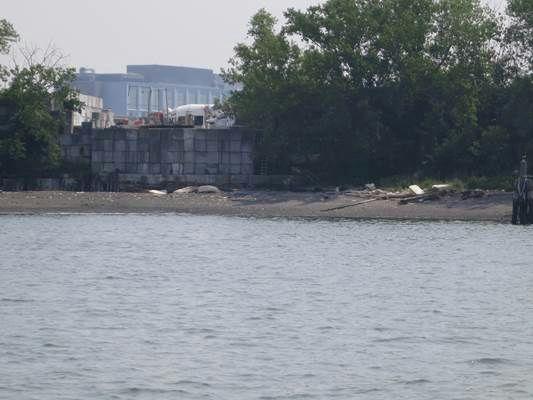
1 Report: 2 derelict barges in Flushing Bay & large source of styrofoam pollution Importance: High All, This report and request is being submitted by Riverkeeper in partnership with two citizen groups: the Guardians of Flushing Bay and the Empire Dragon Boat Team (350 members combined). It is addressed to multiple recipients as jurisdiction may be shared by multiple agencies and services. Please relay this message as needed. Two unidentified and abandoned deck barges are stranded in Flushing Bay next to fixed navigation aid 12. One of the barges has broken in half and half of that barge has drifted to a second location approx. 100 yards SSE of green buoy 11. Please see photos following text. These barges are unsecured and have shifted position on several occasions recently probably during unusually high tide cycles. They represent an immediate extreme risk to commercial and recreational vessel traffic. When (not if, but when) they refloat and shift position again they could drift anywhere in Flushing Bay or the adjacent East River and would endanger the commercial dinner boat operations, commercial cement barges and tugs, petroleum barges transiting the East River, shore facilities such as private and commercial marinas, and the recreational boaters in the area, etc. Riverkeeper has learned that the USACE was notified and has visited the site/barges but has indicated that the it (USACE) does not plan to remove the derelict barges. However it is our understanding that recovery of debris and abandoned vessels which pose a threat to commercial navigation is specifically the responsibility of the USACE and that dedicated funding exists for this purpose. Perhaps an assumption has been made that ownership of the barges cannot be determined because they are unmarked. However a quick review of Google Earth indicates that these two barges (identifiable by the materials on deck throughout the entire period) were secured from as long ago as 6/17/2010 until very recently alongside Ferrara Brothers Building Materials, st Avenue, Flushing, NY Using the Google time slider one can see that on 9/5/09 no barges were secured at Ferrara s western shoreline but on 6/17/10 there were four secured there (see the screen grab below). On 9/20/2010 there were three. On 7/18/2011 only two. From 2/12/2012 until 11/5/2012 there were three. And from 3/2/2014 until the current Google Earth image there were two alongside the Ferrara facility. Sometime after the last Google Earth image was taken the two barges somehow came adrift, first stranding at light 12 and more recently half of one barge drifting across the navigation channel to its current location SSE of buoy 11. This Google time series connects the barges to some degree with Ferrara Brothers (they are likely the owners or certainly know the owners), shows that the Ferrara Brothers site stored a variety of barges over time and actively managed the location where the barges were moored, and finally that the derelict barges now stranded in the Bay are moving. In addition to the extreme immediate risk these barges present to all vessels in Flushing bay and the East River they are also an active large source of Styrofoam pollution. Blocks of white foam have fallen off the deck of one of the barges and are strewn all around Flushing Bay (see photos below). Flushing Bay is an emerging recreation area. Our partner groups tell us that 1,000 people currently paddle on the Bay. Flushing Bay is no longer out of sight, out of mind. At this time, when there is inter agency


2 discussion about the urgent need to prevent plastic pollution, will NYC and the agencies/services copied above will sit by and wait until all the foam blocks fall over side and spread around the harbor? Riverkeeper and partner groups request that these derelict barges be salvaged and removed immediately before this season s tropical storms and fall gales are upon us both of which often result in higher than normal tides and high winds which would likely cause these derelicts to float again andenter commercial shipping channels. We also request that the foam blocks remaining on one barge and the foam blocks strewn about the shoreline of Flushing Bay be retrieved immediately. 6/11/2015 (4 images/riverkeeper) 6/17/2010 Google earth 4 barges alongside Ferrara Brothers. Two of the four are the ones now adrift and abandoned.
3 6/11/2015
4

5 5/9/2015
Serving the Tampa Bay Maritime Community Since Celebrating over 125 Years of Service
 Serving the Tampa Bay Maritime Community Since 1886 Celebrating over 125 Years of Service Tampa Bay Pilots Association Piloting is an essential service of such paramount importance that its continued existence
Some Historical Aspects of Urban Water Systems
 Some Historical Aspects of Urban Water Systems Robert Pitt Department of Civil and Environmental Engineering University of Alabama Tuscaloosa, AL 35487 Ancient springs at Delphi, Greece (site of Oracle)
EX USS SHADWELL Disposal Wreck in Place
 20 February 2018 EX USS SHADWELL Disposal Wreck in Place EX USS SHADWELL, a decommissioned CASA GRANDE Class Dock Landing Ship has had a long history supporting the US Navy. She was built by Newport News
7/21/2014. New Jersey Waterway Debris Removal from Superstorm Sandy: Unprecedented! Superstorm Sandy. Superstorm Sandy.
 New Jersey Waterway Debris Removal from Superstorm Sandy: Unprecedented! Superstorm Sandy Image courtesy of Remik Ziemlinski, Climate Central (www.climatecentral.org) 2 New Jersey Waterway Debris Removal
Dalian VTS Guide for Users
 Dalian VTS Guide for Users 3 rd Edition DALIAN MARITIME SAFETY ADMINISTRATION OF P.R.CHINA DALIAN VESSEL TRAFFIC SERVICE CENTER Introduction The aim of this Guide is to provide vessel traffic service users
Abandoned Vessels and Marine Debris Recent Removal Actions In the Bay Area The Respect in March 2007 a month before sinking in Oakland Estuary
 Abandoned Vessels and Marine Debris Recent Removal Actions In the Bay Area The Respect in March 2007 a month before sinking in Oakland Estuary Photo by Vanessa B. Marlin/The San Francisco Chronicle Shoot
U. S. Coast Guard Sector Boston. November 2016 April 2017
 U. S. Coast Guard Sector Boston November 2016 April 2017 Pollution Statistics for Port of Boston NOV 2016 APR 2017 Reports Received: 38 OSLTF funded responses: 4 Amount Discharged (water & land impact):
Aid to Local Ports FY19 Requests
 City Accomack- Greenbackville Harbor Phase III Accomack-Quinby Harbor Bulkhead Cape Charles- Installation of 4 th breakwater Total Project Cost Amount Requested Proposed Allocation Carryover Request $260,000.00
U.S. Coast Guard - American Waterways Operators Annual Safety Report
 American Waterways Operators U.S. Coast Guard - American Waterways Operators Annual Safety Report National Quality Steering Committee Meeting December 12, 2017 Established Safety Metrics For 17 years,
Sunken Barge ARTHUR J & Tug MADISON Case Study. LCDR Chico Knight, DBA, M.S.
 Sunken Barge ARTHUR J & Tug MADISON Case Study by LCDR Chico Knight, DBA, M.S. July 19, 2012 Background On 19JUL, Sector Detroit was notified by the tug DRUMMOND ISLANDER II that the 110 dredge barge ARTHUR
Port Feeder Barge: Floating Infrastructure for African Ports. 2 nd German-African Infrastructure Forum. Prof. Dr.-Ing.
 2 nd German-African Infrastructure Forum December 3 4, 2014 Munich Port Feeder Barge: Floating Infrastructure for African Ports Prof. Dr.-Ing. Ulrich Malchow Hamburg African port congestion African port
NO INTERNET OR PHONE POWER WATER WHAT WOULD YOU DO? CAN'T GET HOME STUCK AT HOME HAVE TO EVACUATE
 NO WATER NO POWER NO INTERNET OR PHONE CAN'T GET HOME WHAT WOULD YOU DO? HAVE TO EVACUATE STUCK AT HOME In New Zealand emergencies can happen any time, anywhere, and often without warning. Floods, storms,
GALVESTON DISTRICT O&M NAVIGATION MISSION & RESPONSE TO HURRICANE HARVEY
 GALVESTON DISTRICT O&M NAVIGATION MISSION & RESPONSE TO HURRICANE HARVEY 237 237 237 217 217 217 200 200 200 80 119 27 252 174.59 1 255 255 255 0 0 0 163 163 163 131 132 122 239 65 53 Christopher Frabotta
SEA DUBAI. By Rasiena
 SEA DUBAI By Rasiena 1 Progress in Dubai s maritime sector Ideally located between Europe and Asia, Dubai has attracted sailors and traders for centuries. Over the years, Dubai has established itself on
Potomac River Commuter Ferry Feasibility Study & RPE Results
 1.1 Introduction The Prince William County Department of Transportation conducted a route proving exercise (RPE) and feasibility study of a proposed commuter ferry service on the Potomac River between
PARKING CAPACITY REQUIREMENTS
 PARKING CAPACITY REQUIREMENTS Presented to: Antaramian Development Corporation 365 5 th Avenue South Naples, Florida 34102 CONTENTS Page INTRODUCTION... 1 BACKGROUND... 2 EXISTING PARKING CONDITIONS...
Semco's Response to the "Evoikos" Incident and PAJ Equipment Usage. Chris Richard Oil Service Manager Sembawang Maritime
 Semco's Response to the "Evoikos" Incident and PAJ Equipment Usage Chris Richard Oil Service Manager Sembawang Maritime On the evening of October 15k" 1997 one of the worst oil spills in the history of
Lennusadam Marina (Seaplane Harbour) Marina Rules
 Marina Rules") Lennusadam Marina (Seaplane Harbour) Marina Rules Confirmed on 27 November 2014 Marina operator: Estonian Maritime Museum Location of the Harbour: Vesilennuki 6, Tallinn, Estonia Contents 1. General marina
Lennusadam Marina (Seaplane Harbour) Marina Rules Confirmed on 27 November 2014 Marina operator: Estonian Maritime Museum Location of the Harbour: Vesilennuki 6, Tallinn, Estonia Contents 1. General marina
Customer consultation
 Customer consultation Anglian Waterways navigation charges 2018/19 July 2017 Introduction We need to increase the boat registration charges payable for any boat kept, used or let for hire on our Anglian
Superstorm Sandy: State of New Jersey Waterway Debris Removal Project. ~For Official Use Only~
 MEMORANDUM From: On behalf of: Dewberry New Jersey Department of Environmental Protection Environmental Management - Assistant Commissioner's Office Mail Code: 401-03B PO Box 420 Trenton, NJ 08625 (609)
Economic Impacts of Beach Nourishment in Texas
 Galveston Island South Padre Island April 25, 2017 Economic Impacts of Beach Nourishment in Texas Michael Walther Coastal Tech G.E.C., Inc. Reuben Trevino - Galveston Island Park Board of Trustees Special
HARBOR INFRASTRUCTURE INVENTORIES Buffalo Harbor, New York
 HARBOR INFRASTRUCTURE INVENTORIES Buffalo Harbor, New York Harbor Location: Buffalo Harbor is located on the Eastern shore of Lake Erie in the City of Buffalo, NY. Authority: River & Harbor Acts of 1826,
INCIDENTS INVOLVING THE IOPC FUNDS 1992 FUND
 Agenda Item 3 IOPC/OCT17/3/15 Date 17 October 2017 Original English 1992 Fund Assembly 92A22 1992 Fund Executive Committee 92EC69 Supplementary Fund Assembly SA14 INCIDENTS INVOLVING THE IOPC FUNDS 1992
The Huizen Municipality Port Decree
 No. 9 The Council of Huizen Municipality; having read the proposal of the Municipal Executive dated 26 October 2010; with a view to Section 149 of the Dutch Municipalities Act (Gemeentewet) d e c r e e
Lake Tahoe Shoreline Plan 03 Policy Topic: Access Issues
 Lake Tahoe Shoreline Plan 03 Policy Topic: Access Issues V9 Last Updated 03.10.2017 1 Brief Description Physical access to the waters of Lake Tahoe is one of the key issues surrounding the Shoreline Plan
DOCKING AND ROUTING PLAN
 DOCKING AND ROUTING PLAN TABLE OF CONTENT Contents Table of content... 2 1 Introduction... 3 1.1 Background... 3 1.2 Document Scope... 3 1.3 Harbour dues... 3 2 ROUTING TO SHIPYARD... 4 2.1 General...
TANJONG PAGAR/KEPPEL/BRANI TERMINALS. DEPTH A/S (m)
") TANJONG PAGAR/KEPPEL/BRANI TERMINALS BERTH DEPTH A/S (m) APPROACH DEPTH (m) T01 13.6 14.0 T02 13.6 14.5 T03 13.6 13.8 T04 11.0 9.7 T05 14.8 15.0 T06 13.6 14.2 REMARKS T07 12.4 12.6 Shallower depths exist
TANJONG PAGAR/KEPPEL/BRANI TERMINALS BERTH DEPTH A/S (m) APPROACH DEPTH (m) T01 13.6 14.0 T02 13.6 14.5 T03 13.6 13.8 T04 11.0 9.7 T05 14.8 15.0 T06 13.6 14.2 REMARKS T07 12.4 12.6 Shallower depths exist
REVISED DRAFT Integrated Hurricane Sandy General Reevaluation Report and Environmental Impact Statement. Atlantic Coast of New York
 REVISED DRAFT Integrated Hurricane Sandy General Reevaluation Report and Environmental Impact Statement Atlantic Coast of New York East Rockaway Inlet to Rockaway Inlet and Jamaica Bay Appendix F Public
Annual Summary of Marine Safety Reports
 14 th February 2014 Page 1 Annual Summary of Marine Safety Reports Notes 1. Incident categories are consistent with the requirements of the MAIB and the British Port s Association s National Reporting
2- Pilotage Cost Tonnage. 1- Pilotage Cost Tonnage. Currency
 2- Pilotage Cost Tonnage 3* 4* Currency Harbor Pilot in the Port area And Docks (Egyptian 45 30 Until 999 60 40 1000-4999 90 60 5000-9999 112.5 75 10000-19999 217.5 145 20000-29999 322.5 215 30000-39999
Chair and Members of Harbour East - Marine Drive Community Council. Brad Anguish, Director, Parks and Recreation
 P.O. Box 1749 Halifax, Nova Scotia B3J 3A5 Canada Item No. 15.1.1 Harbour East-Marine Drive Community Council December 3, 2015 TO: SUBMITTED BY: Chair and Members of Harbour East - Marine Drive Community
Isle Royale Info Section 5: Campgrounds
 Isle Royale Info Section 5: Campgrounds Overview: All of the campgrounds are very well marked and the sites have shelters and or tent pads. Shelters are typically available at campgrounds on Lake Superior,
Official Quarterly Newsletter Spring Fort Schuyler Maritime Alumni Assoc., Inc. first and foremost, since Eagle Announcement
 Official Quarterly Newsletter Spring 2014 Fort Schuyler Maritime Alumni Assoc., Inc. FIRST AND FOREMOST, SINCE 1903 first and foremost, since 1903 Mayday, Mayday. This is the Sea Lion. We are sinking.
State of the Waterway 2017
 State of the Waterway 2017 Steven W. Nerheim Director VTS Houston/Galveston Lone Star Harbor Safety Committee 2 FEBRUARY 2018 U.S. Port Rankings 2015 1 South Louisiana, LA, Port of 259.1-3.07% 15 Texas
HARBOR INFRASTRUCTURE INVENTORIES Erie Harbor, PA
 HARBOR INFRASTRUCTURE INVENTORIES Erie Harbor, PA Harbor Location: Erie Harbor is located on the southern shore of Lake Erie in the City of Erie, PA about 98 Miles southwest of Buffalo. Authority: River
NOTE ALL CRUISES WEATHER DEPENDANT. FOR MORE INFO CALL or, (cell)
") 2015 Skippers meeting Sunday Nov 29th @ 12:noon at Reed Point Marina in the Marine Studies building just west from the main office on the docks to the left of Thunderbird Yacht Sales FOR MORE INFO CALL
2015 Skippers meeting Sunday Nov 29th @ 12:noon at Reed Point Marina in the Marine Studies building just west from the main office on the docks to the left of Thunderbird Yacht Sales FOR MORE INFO CALL
Best Practices for the Responsible Disposal of Derelict Vessels. A case study of the disposal of an abandoned derelict by a remote Harbour Authority
 Best Practices for the Responsible Disposal of Derelict Vessels A case study of the disposal of an abandoned derelict by a remote Harbour Authority Best Practices for the Responsible Disposal of Derelict
US COAST GUARD Hurricane Season LCDR Deon Scott Chief, Planning Division USCG Sector Houston-Galveston
 US COAST GUARD Hurricane Season 2017 LCDR Deon Scott Chief, Planning Division USCG Sector Houston-Galveston Hurricane Season 1 June through 30 November each year. September is historically the most active
Harbourmaster s Office
 Harbourmaster s Office Recommendations That the Board: i. note the recent transfer of the harbourmaster department from Auckland Council to Auckland Transport. ii. note the roles and responsibilities of
THE RIVER MEDWAY A LEADING CENTRE OF BRITISH, EUROPEAN AND WORLD MARITIME HERITAGE
 1. Introduction The river Medway is already a leading centre of British, European and World maritime heritage. It s just that not too many local people realise it yet. The role of the river, in establishing
NEWBORO AND PORTLAND HARBOUR REDVELOPMENT PLANS
 INTRODUCTION The Municipal docks in both Newboro and Portland were transferred to the Township of Rideau Lakes by Parks Canada in 2002. Little has been done to improve the docks physical condition or role
Mollusk Restoration around Wastewater Treatment Plant (NY) # Progress Report: August 26, 2011
 # Progress Report: August 26, 2011") To date, the project has involved numerous teleconferences, emails and permitting exercises with the goal of ribbed mussel seed collection, construction and installation of a mussel raft in the Bronx/East
To date, the project has involved numerous teleconferences, emails and permitting exercises with the goal of ribbed mussel seed collection, construction and installation of a mussel raft in the Bronx/East
Header i
 Header i 048285014.10 Header Sub Title Body Text here. Body text here. Body text here. Section 1... 1 Executive Summary... 1 Opportunities and Constraints... 3 Overall Opportunities and Constraints Map
Channel and Facility Guidelines
 Channel and 54 Handling Guidelines for Vessel Movement Tampa Bay Main Channel Draft of 38-03 plus tide at any time, to a maximum of 40-03. Drafts of over 38-03 feet must be started in at least 4 hours
San Francisco Bay Area Water Trail Site Description for. Suisun City Marina. Launch ramps and docks Suisun Channel Parking Lot
 1 San Francisco Bay Area Water Trail Site Description for Suisun City Marina Location, Ownership, and Management: Suisun City Marina is located on Kellogg St., approimately a half mile from Suisun City's
1. USACE Response to Sandy Ports 2. NAVFAC Response to Sandy - Base 3. USSOUTHCOM/NAVFAC Response in HaiC Port Au Prince Port
 1. USACE Response to Sandy Ports 2. NAVFAC Response to Sandy - Base 3. USSOUTHCOM/NAVFAC Response in HaiC Port Au Prince Port Marcelo Salles, USACE LNO to USSOUTHCOM (With help from USACE NY District,
ADVICE ON MOZAMBIQUE PORTS. P&I ASSOCIATES (PTY) LTD
 LTD") ADVICE ON MOZAMBIQUE PORTS. P&I ASSOCIATES (PTY) LTD All the ports in Mozambique are owned by CFM (Caminhos de Ferro de Mozambique). Many of the ports have been given to private companies to manage the
ADVICE ON MOZAMBIQUE PORTS. P&I ASSOCIATES (PTY) LTD All the ports in Mozambique are owned by CFM (Caminhos de Ferro de Mozambique). Many of the ports have been given to private companies to manage the
Ribbon Cliff - Ribbon Mesa text and photos by Charlie Hickenbottom
 Ribbon Cliff - Ribbon Mesa text and photos by Charlie Hickenbottom Looking for something a little different than Sage Hills or Saddlerock? Perhaps something a little wilder, a little less traveled? Look
CURRENT PORT CHARGES AND TARIFFS FROM 01/01/2016 TO
 Ministry of Public Works and Transport STATE-OWNED PORTS PORT AUTHORITY OF CARTAGENA CURRENT PORT CHARGES AND TARIFFS FROM 01/01/2016 TO This is an unofficial document. Official port charges and tariffs
INDEX OF RISK ASSESSMENTS
 A. PUBLIC COMMERCIAL (NON-LEISURE) ACTIVITY AFLOAT WITHIN HARBOUR LIMITS Merchant Shipping Transit within Harbour Limits 001 Bunkering 002 Cruise Ships Transit within Harbour limits 003 Bunkering 004 Warships
Port Everglades Master Plan Update Tenant Workshop. July 12, Port Everglades Master Plan Update 2006
 Tenant Workshop July 12, 2007 1 Original 2026 Year Vision Plan DYNEGY PROPERTY SHARED AIRPORT/SUPPORT FACILITY 12 12 2 Input from Tenants Northport Convention Center carve out Expanded cruise berth at
REPORT INTO THE FIRE AND SUBSEQUENT GROUNDING OF THE MV "PATRIARCH" ON 1ST SEPTEMBER, 2004
 REPORT INTO THE FIRE AND SUBSEQUENT GROUNDING OF THE MV "PATRIARCH" ON 1ST SEPTEMBER, 2004 The Marine Casualty Investigation Board was established on the 25 th March, 2003 under The Merchant Shipping (Investigation
Esquimalt Harbour Practices and Procedures. 28 February 2019
 Esquimalt Harbour Practices and Procedures 28 February 2019 1. Preamble 2. Definitions 3. Authority of Harbour Official 4. Entry, Movement, Departure Clearances 5. Speed Limits 6. Controlled Access Zones
VOLUME 1 JANUARY 2016
 JANUARY 2016 VOLUME 1 Japanese Marine Debris Aerial Imagery Analysis and GIS Support Hawaii Coral Reef Initiative This publication is a result of funding from the Japanese Tsunami Marine Debris Gift Fund,
PRESS RELEASE WRECK REMOVAL OPERATION OF M/V GOODFAITH, ANDROS ISL. GREECE
 PRESS RELEASE September 28, 2015 WRECK REMOVAL OPERATION OF M/V GOODFAITH, ANDROS ISL. GREECE On February 10 th, M/V GOODFAITH amid severe weather run aground on the north coast of Andros. Bulk Carrier
Regional Cooperation in Search and Rescue (SAR) Operations. - An Australian Perspective
 Operations. - An Australian Perspective") Indian Ocean Rim Association Indian Ocean Dialog 2015 Perth 6 September 2015 Regional Cooperation in Search and Rescue (SAR) Operations - An Australian Perspective John Young GM Search & Rescue Scope Regional
Indian Ocean Rim Association Indian Ocean Dialog 2015 Perth 6 September 2015 Regional Cooperation in Search and Rescue (SAR) Operations - An Australian Perspective John Young GM Search & Rescue Scope Regional
District Court, E. D. New York. November 19, 1890.
 YesWeScan: The FEDERAL REPORTER THE BAY OF NAPLES. 1 HALL ET AL. V. THE BAY OF NAPLES. District Court, E. D. New York. November 19, 1890. 1. SALVAGE FIRE IN OIL CARGO. A vessel, loaded with case oil and
Port Dues and Charges of the Freeport of Riga
 Approved by Decree No 38, 16.06.2000 of Board of the Freeport With amendments of: 22.09.2000 22.12.2000 27.04.2001 08.06.2001 19.10.2001 17.12.2001 18.12.2002 Port Dues and Charges of the Freeport of Riga
Ocean County Brian Berkowitz (Partner Adam Nassr Monmouth County)
") Ocean County Brian Berkowitz (Partner Adam Nassr Monmouth County) 1. County Summary Ocean County, founded in 1850, is located along the Jersey Shore in the state of New Jersey and has been one of the fastest
Ocean County Brian Berkowitz (Partner Adam Nassr Monmouth County) 1. County Summary Ocean County, founded in 1850, is located along the Jersey Shore in the state of New Jersey and has been one of the fastest
District Court, E. D. New York. March 3, 1888.
 THE WASP. 1 HUDSON ET AL. V. THE WASP. District Court, E. D. New York. March 3, 1888. SALVAGE WHAT CONSTITUTES PERIL. The barge Wasp, while being towed up the Atlantic coast by the tug America, encountered
FINAL REPORT APRIL 2016
 APRIL 2016 FINAL REPORT Japanese Tsunami Marine Debris Aerial Imagery Analysis and GIS Support Hawai i Coral Reef Initiative This publication is a result of funding from the Ministry of the Environment
An Education In Offshore Pipeline Construction. By Allyn Stott
 An Education In Offshore Pipeline Construction. By Allyn Stott In the mid 1980s I had an opportunity to visit an offshore pipeline laying barge. Fortunately the weather was clear, warm, and just about
Andrew Thin Chairman Geoff Aitkenhead Board Member Katie Hughes Director of Estates Russell Thomson Waterway Area Manager, Caledonian Canal
 Caledonian Canal Customer Forum 10.5.14 Venue: Eden Court Theatre, Inverness Scottish Canals attendees: Andrew Thin Chairman Geoff Aitkenhead Board Member Katie Hughes Director of Estates Russell Thomson
SPOT COMMENTARY 1/17 Kidnapping, Harassment and Suspicious Activities in Waters off East Sabah and Southern Philippines
 SPOT COMMENTARY 1/17 Kidnapping, Harassment and Suspicious Activities in Waters off East Sabah and Southern Philippines 20 Jan 2017 ifc_do@defence.gov.sg +65 9626 8965 (Mobile) +65 6594 5728 (Office) Purpose
Madagascar. Ports description
 Madagascar Ports description Toamasina (Tamatave) Access Specification Map reference number and Description 1 Mole A - General cargo Length (m) Draught (m) East 110 6.50 Head 59 7.5 West 192 5 Remarks
SANTANDER PORT CONTROL PROCEDURE
 SANTANDER PORT CONTROL PROCEDURE 1.- GEOGRAPHICAL APPLICATION LIMITS This procedure is applicable to all ships and crafts navigating in areas I and II of the Port of Santander, and also in the anchorage
Bye-Laws for the Port of of Gothenburg
 1 (7) Bye-Laws for the Port of of Gothenburg Göteborg THE MUNICIPALITY OF GÖTEBORG THE MUNICIPALITY OF GOTHENBURG THE COUNTY ADMINI- STRATIVE BOARD OF VÄSTRA GÖTALAND THE COUNTY ADMINISTRATIVE BOARD OF
Collaborations with Harbors and West Coast National Marine Sanctuaries (completed, ongoing and planned)
") Olympic Coast National Marine Sanctuary (OCNMS) OCNMS supported efforts by the Makah Tribe to replace a commercial fishing pier in Port of Neah Bay Port of Neah In 2013, OCNMS wrote a support letter focusing
Olympic Coast National Marine Sanctuary (OCNMS) OCNMS supported efforts by the Makah Tribe to replace a commercial fishing pier in Port of Neah Bay Port of Neah In 2013, OCNMS wrote a support letter focusing
Terminal Symposium February Houston Traffic
 Terminal Symposium February 2017 Houston Traffic U.S. Port Rankings 2015 (Millions of short tons and % of change from 2014 to 2015.) 1 South Louisiana, LA, Port of 259.1-3.07% 15 Texas City, TX 42.9-10.25%
Nassau County Bridge Authority (N.Y. Public Authorities Law 651) 2007 Annual Report
 2007 Annual Report") Nassau County Bridge Authority (N.Y. Public Authorities Law 651) 2007 Annual Report The Nassau County Bridge Authority is a public benefit corporation created by the New York State Legislature in 1945
Nassau County Bridge Authority (N.Y. Public Authorities Law 651) 2007 Annual Report The Nassau County Bridge Authority is a public benefit corporation created by the New York State Legislature in 1945
SYNOPSIS WEATHER AND SNOWPACK
 Peak 6996 Avalanche Fatality Incident Report Glacier National Park, MT Date of Avalanche: 31 March 2010 Date of Investigation: 2 April 2010 Investigation Team: Erich Peitzsch (USGS), Ted Steiner (Chugach
Water Resources Update after NCGA Long Session
 Water Resources Update after NCGA Long Session North Carolina Beach Inlet & Waterway Association Annual Conference November 16, 2015 Division of Water Resources Overview New Name / Reorganization Jordan
Marine Exchange of Alaska Port of Juneau Navigation Study
 Safe, Secure, Efficient and Environmentally Responsible Maritime Operations 1000 Harbor Way, Juneau, Alaska 99801 Ph: (907) 463-2607 December 10, 2008 Mr. John Stone Port Director City of Juneau 155 S.
CORPS OF ENGINEERS ALASKA DISTRICT Dredging Projects. Michael Tencza, PE Operations Project Manager November 4, 2015
 CORPS OF ENGINEERS ALASKA DISTRICT 2016 Dredging Projects Michael Tencza, PE Operations Project Manager November 4, 2015 US Army Corps of Engineers Building and Preserving Alaska s Future AWARDED CONTRACTS
LAGUNA ISLES DEVELOPMENT
 DEVELOPMENT FOR SALE LAGUNA ISLES DEVELOPMENT State Highway 361 South of Downtown Port Aransas, Texas 44.77 ACRES MIXED-USE DEVELOPMENT + 300 planned SF lots, most with bay or golf course frontage and
Nassau County Bridge Authority (N.Y. Public Authorities Law 651) 2011 Annual Report
 2011 Annual Report") Nassau County Bridge Authority (N.Y. Public Authorities Law 651) 2011 Annual Report The Nassau County Bridge Authority is a public benefit corporation created by the New York State Legislature in 1945
Nassau County Bridge Authority (N.Y. Public Authorities Law 651) 2011 Annual Report The Nassau County Bridge Authority is a public benefit corporation created by the New York State Legislature in 1945
MARITIME. Protect Your Assets. Lay-up seminar MOU - CEFOR. Dec. 2016, Oslo, Ungraded SAFER, SMARTER, GREENER
 MARITIME Protect Your Assets Lay-up seminar MOU - CEFOR Dec. 2016, Oslo, 1 SAFER, SMARTER, GREENER Contents Market situation A challenge ahead New revised Class Guideline Advisory V.S Class Service 2 Market
Ufs. No Notices to Mariners, SWEDEN Swedish Maritime Administration.
 Ufs No 512 2014-09-18 Notices to Mariners, SWEDEN Swedish Maritime Administration Editorial office Swedish Maritime Administration Ufs/BALTICO 601 78 NORRKÖPING Sweden tel: 0771 630 605 e-mail: ufs@sjofartsverket.se
PANAMA MARITIME AUTHORITY INVESTIGATION INTO THE CIRCUMSTANCES SURROUNDING THE ALLISION BETWEEN THE MV NAESBORG AND THE M/V VOYAGER II
 PANAMA MARITIME AUTHORITY INVESTIGATION INTO THE CIRCUMSTANCES SURROUNDING THE ALLISION BETWEEN THE MV NAESBORG AND THE M/V VOYAGER II R-030-07/DISAM ON SEPTEMBER 12 TH, 2007 IN THE APPROACHES TO GALVESTON
QUEENSLAND RECREATIONAL BOATING COUNCIL INC (QRBC) Report of Meeting
 Report of Meeting") QUEENSLAND RECREATIONAL BOATING COUNCIL INC (QRBC) Report of Meeting 9 08-2017 Items of interest from the August 9 th 2017 meeting of the Queensland Recreational Boating Council held at the Queensland
QUEENSLAND RECREATIONAL BOATING COUNCIL INC (QRBC) Report of Meeting 9 08-2017 Items of interest from the August 9 th 2017 meeting of the Queensland Recreational Boating Council held at the Queensland
Waterway Access and the Atlantic Intracoastal Waterway in Florida
 Waterway Access and the Atlantic Intracoastal Waterway in Florida Issues: Maintenance - Funding (costs), Infrastructure needs, permitting Management Consideration of the M-95 system, Cooperation among
LITTLEHAMPTON HARBOUR BOARD
 LITTLEHAMPTON HARBOUR BOARD Harbour Office Pier Road Littlehampton West Sussex BN17 5LR Telephone: 01903 721215 Facsimile: 01903 739472 PORT WASTE PLAN REVISED FEBRUARY 2011 Contents 1 Distribution...
PULAU SEBAROK - VOPAK TERMINAL (OSV) MAX DISPL. (tonnes) MAX LOA(m) 45, ,000 80, ,000 13,000 12, ,000 19,500 19,500
 MAX DISPL. (tonnes) MAX LOA(m) 45, ,000 80, ,000 13,000 12, ,000 19,500 19,500") PULAU SEBAROK - VOPAK TERMINAL (OSV) JETTY DEPTH A/S(m) APPROACH DEPTH(m) MAX LOA(m) MAX DISPL. (tonnes) REMARKS OSV2 11.7 264 45,800 OSV3 16.9 370 210,000 see para. 3 under General Information OSV4 12.9
PULAU SEBAROK - VOPAK TERMINAL (OSV) JETTY DEPTH A/S(m) APPROACH DEPTH(m) MAX LOA(m) MAX DISPL. (tonnes) REMARKS OSV2 11.7 264 45,800 OSV3 16.9 370 210,000 see para. 3 under General Information OSV4 12.9
Alexandria Port, Egypt
 Alexandria Port, Egypt Source: This information has been extracted from the WFP Logistics Capacity Assessment for Egypt. This LCA is a work in progress and not all sections are complete. This material
Marine Debris Distribution, Variation and Pattern/Seasonal Changes along the Coast and on Sea Surface of the Kagoshima Bay
 Marine Debris Distribution, Variation and Pattern/Seasonal Changes along the Coast and on Sea Surface of the Kagoshima Bay Benjamin Dotto MAJANGA 1, Shigeru FUJIEDA 2, Ryuichiro NISHI 3 and Kazunori HOSOTANI
PRACTICES AND PROCEDURES TO BE FOLLOWED BY SHIPS IN THE PORT OF NANAIMO
 PRACTICES AND PROCEDURES TO BE FOLLOWED BY SHIPS IN THE PORT OF NANAIMO Updated May 7, 2009 Nanaimo Port Authority PO Box 131, 104 Front Street Nanaimo, BC V9R 5K4 Tel. 250-753-4146 Fax 250-753-4899 e
 CEMVP-PD-C MEMORANDUM FOR FILE SUBJECT: Supplement No. 4,, Design Memorandum 10, Kaskaskia River, Illinois 1. References: a., Design Memorandum No. 10, approved 1997 (includes Supplements 1-3) b. ER 1130-2-550,
in the heart of the columbia river gorge
 in the heart of the columbia river gorge RID GE COLUMBIA RIVER PORTLAND CITY OF HOOD RIVER LB TOL The Best Western Plus Hood River Inn is located in the heart of the Columbia River Gorge, America s first
Statutory Order no of 25 November 2004 (Unauthorized translation by the Danish Coastal Authority) Statutory Order on Standard Regulations for
 Statutory Order on Standard Regulations for") Statutory Order no. 1146 of 25 November 2004 (Unauthorized translation by the Danish Coastal Authority) Statutory Order on Standard Regulations for the Observance of Good Order in Danish Commercial Ports
Statutory Order no. 1146 of 25 November 2004 (Unauthorized translation by the Danish Coastal Authority) Statutory Order on Standard Regulations for the Observance of Good Order in Danish Commercial Ports
Engineering With Nature Geographic Project Mapping Tool (EWN ProMap)
") Engineering With Nature Geographic Project Mapping Tool (EWN ProMap) Cynthia Banks Program Manager Burton Suedel, PhD Research Biologist Michelle Bourne Research Biologist U.S. Army ERDC 23 June 2015 Dredging
Engineering With Nature Geographic Project Mapping Tool (EWN ProMap) Cynthia Banks Program Manager Burton Suedel, PhD Research Biologist Michelle Bourne Research Biologist U.S. Army ERDC 23 June 2015 Dredging
Pearl String Service
 Pearl String Service A touch of traditional navigation We offer segments ex Northern Europe (Antwerp, Hamburg); Asia (Shanghai) and North America (Philadelphia). You are invited to completely relax and
TALVESADAM Port rules
 TALVESADAM Port rules Pärnu Haldusteenused Suur-Sepa 16, Pärnu 2013 2 Declaration by the port authority: These rules are mandatory and extend to all the vessels visiting the port irrespective of their
MARITIME AND PORT AUTHORITY OF SINGAPORE SHIPPING CIRCULAR NO. 3 OF 2014
 MARITIME AND PORT AUTHORITY OF SINGAPORE SHIPPING CIRCULAR NO. 3 OF 2014 MPA Shipping Division 460 Alexandra Road 21 st Storey PSA Building Singapore 119963 Fax: 63756231 http://www.mpa.gov.sg 21 January
VERSION DATE OF ISSUE DESCRIPTION PREPARED CHECKED APPROVED Technical note HHP DKA OYBE
 DRAMMENREGIONENS VIRKESTERMINALER DEVELOPMENT OF NEW TIMBER TERMINAL NAVIGATION AND BERTH LOCATION STUDY ADDRESS COWI A/S Parallelvej 2 2800 Kongens Lyngby Denmark TEL +45 56 40 00 00 FAX +45 56 40 99
Southwind Marina Sinton Drive Pensacola, Florida Unique Opportunity to Acquire a 90 Slip Marina With Excellent Investment Potential
 Urban Realty Southeast is pleased to present Southwind Marina 10121 Sinton Drive Pensacola, Florida 32507 Unique Opportunity to Acquire a 90 Slip Marina With Excellent Investment Potential Closest marina
Among others, the following relevant deficiencies were listed in that day in the inspection report:
 SUAT BEY IMO9070515 F l a g : P a n a ma K eel Dat e: 01. 01. 1992 Type: General cargo Class: RMRS RO : US B / P HRS Gross Tonnage: 2608 M/V Suat Bey arrived in Catania (Italy) on 09nov2013, with a standard
Coral reefs are in trouble; they are being stressed on a global scale by diverse factors many of which are related to human stressors which are now
 Coral reefs are in trouble; they are being stressed on a global scale by diverse factors many of which are related to human stressors which are now compounded by environmental change. Today increasing
Access: The rocky shoreline is only accessible via private property.
 10. Whale Cove Site description: Whale Cove is a small cove fringed by private homes and condominiums with diverse and relatively undisturbed rocky intertidal and subtidal habitat located approximately
The Falls: A Visitor & Interpretive Center for the Upper Lock
 The Falls: A Visitor & Interpretive Center for the Upper Lock Image courtesy of Northern Spark Surface by Aaron Dysart Illuminate the Lock is a program of Mississippi Park Connection The Falls Initiative
Welcome to Marco Island
 Marco Island is located in Southwest Florida, on the Gulf of Mexico, 178 miles south of Tampa,16 miles south of Naples, and 104 miles due west of Miami. Marco is the northern most and largest of the famous