PLACE RECORD FORM CITY OF MELVILLE, WESTERN AUSTRALIA LOCAL GOVERNMENT INVENTORY PLACE REFERENCE NO.: BN06 REINSTATE + NEW LISTINGS
|
|
|
- Jeffery Bennett
- 5 years ago
- Views:
Transcription

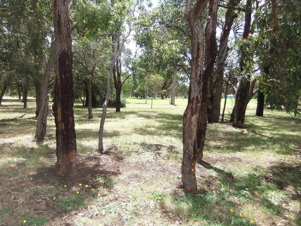
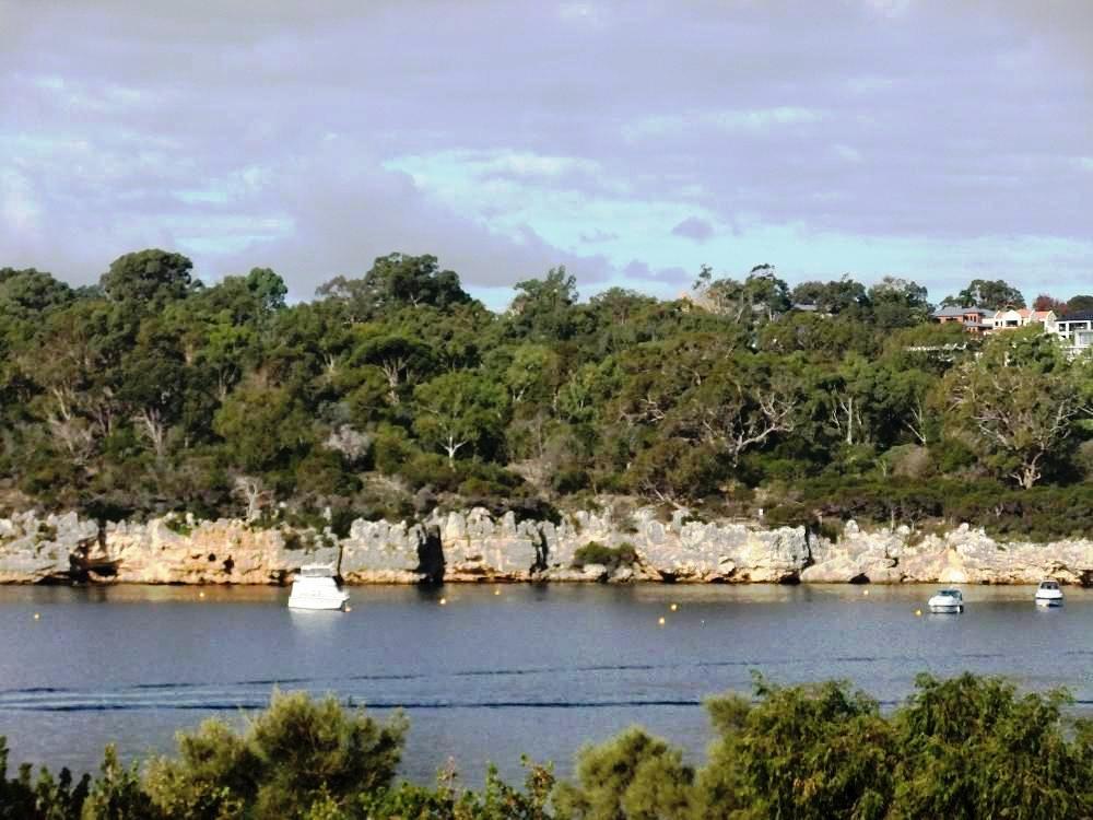
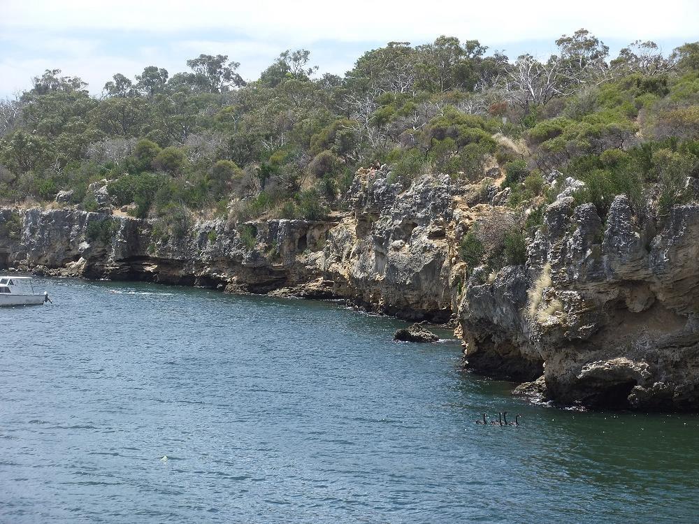
1 CITY OF MELVILLE, WESTERN AUSTRALIA PLACE RECORD FORM LOCAL GOVERNMENT INVENTORY PLACE REFERENCE NO.: BN06 REINSTATE + NEW LISTINGS NAME: POINT WALTER RESERVE, including POINT WALTER GOLF COURSE and BLACKWALL REACH RESERVE OTHER NAMES: -- PIN NO. (Landgate): and LAND DESCRIPTION: Lot 11240, Diagram Certificate of Title Volume LR-3012 Folio 804; and Crown Reserve 4813 LOCATION: CONSTRUCTION DATE: PLACE TYPE: Honour Avenue and Carroll Drive, and Blackwall Reach Parade, Bicton Natural Reserves and Golf Course USE: Original Use: Aboriginal site; then Recreational and Natural Reserve Current Use: Recreation and Natural Reserve incorporating memorial trees; Public Golf Course HERITAGE LISTINGS: ARCHITECT: BUILDER: - MHI 19 December 1994, Place Ref. BN06; - Australian Heritage Council Register of the National Estate Place ID Point Walter Migrant Reception Centre Indicative Place ; - Department of Aboriginal Affairs Register of Aboriginal Sites Site ID 3536 Swan River and Site ID 3650 Blackwall Reach, Bicton. ARCHITECTURAL STYLE: CONDITION: Sound and well maintained. PHYSICAL DESCRIPTION: The place comprises the natural and introduced landscape abutting the bank of the Swan River, and incorporates the sand bar, jetty, public roads and pathways, paved parking areas, tennis courts, and grassed recreational areas and public amenities. Natural bushland with undergrowth cleared, tree stock retained, and greens, fairways and clubhouse/carpark introduced in the bushland setting. A publicly accessible natural landscape reserve incorporating limestone cliffs and caves at the junction with the Swan River, indigenous landscape of trees and undercover, with sensitively introduced walkways, viewing platform, safety fencing, carpark and interpretive signage. HISTORICAL NOTES: Point Walter and Blackwall Reach were part of the Beeliar Nyoongar campsites and hunting grounds. In the summer months the large variety of plants and animals in the area provided the Aborigines with an abundance of food and other resources. The Beeliar Nyoongars would regularly burn sections of these areas which kept the understorey low and was considered a useful technique for flushing out game. The Aboriginal name for Point Walter is Dyundalup (Dyoondalup) and for Blackwall Reach is Jenalup; the Swan River was named Derbarl Yerrigan which means brackish place of the turtle. In 1827, Captain James Stirling in his exploration of the Swan River to identify a suitable site for settlement, named Point Walter after his brother, Walter. Land was acquired in 1830 by the first European settlers Lionel Lukin and Alfred Waylen (hence Alfred Cove). Waylen built a villa at Point Walter in 1830 (later burned down), and acquired a further 700 acres in 1831 extending his grant from Point Walter as far east along the Swan River frontage to Alfred Cove. Popular access by the community saw the area used for camping, swimming, picnicking and crabbing. A jetty was subsequently constructed since access was solely by water; ferries and yachting parties frequented the Point and the two Walter Golf Course and, Bicton Page 1 of 5
2 tearooms constructed to service the visitors. A tavern, adjacent to the jetty was known as The Halfway House, midway between Fremantle and Perth. A timber bathing shed was developed just east of the jetty. In December 1915, a tramway was constructed linking Canning Road with Point Walter, so popular was this recreation site. A limestone road was eventually built, providing access for horse-drawn vehicles from Canning Road. In 1907 (1895?) the State Government purchased Point Walter, declaring the site as an A-Class Reserve. In 1912, the Melville Roads Board was appointed to manage the Reserve. The Reserve was officially opened in 1914 on 30 November. The Perth-Fremantle railway opening saw a decline in popularity for Point Walter, which became a quiet backwater. Steamers on the Swan River stopped using a narrow and shallow channel that had been cut in the sand bar, preferring to negotiate around the bar, and the tearooms facilities struggled through lack of patronage. A growth in ocean beach patronage by the public saw a further decline in the use of Point Walter. The control of the Reserve, as a consequence, passed to control by the Parks and Gardens Board in The Depression of the 1930s had a further negative impact, through unemployment, on the recreational use of the Reserve. World War II further impacted badly on public use of the Reserve. Point Walter fell into disrepair until in November 1952 the Reserve was vested in the Melville Roads Board at which time old buildings were removed, the river beach was restored, a new kiosk constructed, new changerooms and new toilet facilities provided. In 1980, the Department of Sport and Recreation took control of 6.5 hectares of the Reserve - the area that had been in use for Army Training purposes and, following World War II, a Migrant Settlement Hostel/Camp from 1948 to In 1986, the remaining Hostel buildings were removed and a considerable sum spent to develop that inland section of the Reserve as a sport and recreational facility to be seen on that site today in 2013, managed by the Department of Sport and Recreation for use as a new centre for sport and conferences. Today, is a popular well-maintained public recreational centre, readily accessible by ferry and yachts to the jetty or by road from Canning Highway. The golf course site was formerly part of the, a property acquired at Point Walter in 1830 by the initial settlers Lionel Lukin and Alfred Waylen and becoming part of the A Class Reserve acquired by Government in The Reserve is now managed by the. is a designated conservation and recreation area, once an important Aboriginal women s area called Jenalup. Aborigines from the Beelia family group and Whadjug tribes called the trail, on the south side of the river, Yorga meaning women s trail. Jenalup was a place for women and children to learn life skills at a place plentiful in fish, native yams, and limestone caves providing fresh water. The sandbar at the adjoining Point Walter, then known as Dyundalup, was the connection between the trails in a favourite tribal ground for the Nyungar people. Dyundalup means place of long white flowing hair, the sand bar and the white waves breaking over it. Blackwall Reach was named in 1896 by Commander L. S. Dawson RN, Admiralty Surveyor, after an area in the Thames River near Greenwich, UK. The reserve formed part of a farm and tavern in the later 1800s, connected by a tramline from Canning Highway until the 1950s. The site is important for its natural landscape of coastal vegetation, limestone formations, aquatic species and dry land species. HISTORIC THEME/S (HCWA THEME/S): Australian Historic Themes: 1.4 Appreciating the natural wonders of Australia Clearing vegetation Developing public parks and gardens Conserving fragile environments. HCWA Themes: 102 Aboriginal occupation 409 Environmental occupation 601 Aboriginal people 602 Early settlers. CONSTRUCTION MATERIALS: - Natural and introduced landscape; introduced tennis courts, roadways, pathways, jetty, parking areas, public amenities and interpretive material; - Natural landscape; and introduced golf course, clubhouse and car parking area; - Natural land and marine characteristics; introduced pathways, interpretive signage, paved carpark, and safety fencing. STATEMENT OF SIGNIFICANCE is a place of exceptional cultural heritage significance for the following reasons: the site borders the Swan River and retains natural bushland and marine characteristics; the site has significance to the Aboriginal people, for a period extending well back prior to European settlement; the place has historic value for original naming by Captain James Stirling, and for early settlement in 1830 by Lionel Lukin and Alfred Waylen; the place has early association with the Melville Roads Board, in 1912, the Fremantle Tramway Board, in 1915, officially opening in November 1914; Point Walter has since the 1920s been a popular community place for camping, swimming, crabbing and public recreation, to the present day. The is important for the retained natural bushland setting, the introduced public golf course amenity and is a place of historic significance as part of the. Walter Golf Course and, Bicton Page 2 of 5


3 is important as a place of natural coastal vegetation, an Aboriginal place of significance, and now a recreational site. SIGNIFICANT ITEMS: The site overall for historic reasons; the natural and introduced landscape; the marine foreshore, jetty and the sand bar; and the memorial tree plantings. LEVEL OF SIGNIFICANCE: - Considerable cultural heritage significance. - Considerable cultural heritage significance; - Considerable cultural heritage significance. MANAGEMENT CATEGORY: Category A DEVELOPMENT CONTROL CODE: National MAIN SOURCES: Interpretive material on site; Australian Heritage Council Register of the National Estate documentation for Place ID Point Walter Migrant Reception Centre ; Point Walter, Ric Turner, undated; in the 1920s, Alfred Chate, 1997; Blackwall Reach and Point Walter Bushland Management Plan,, July 1994; Swan River, Perth, Western Australia, Creative Spirits, 22 November ASSESSMENT DATE: ASSESSOR: 2013 Ronald Bodycoat AM.KSJ.LFRAIA Walter Golf Course and, Bicton Page 3 of 5


4 Walter Golf Course and, Bicton Page 4 of 5


5 Walter Golf Course and, Bicton Page 5 of 5
MAIN LAKE PROVINCIAL PARK
 MAIN LAKE PROVINCIAL PARK PURPOSE STATEMENT AND ZONING PLAN March 2003 MAIN LAKE PROVINCIAL PARK Purpose Statement and Zoning Plan Primary Role The primary role of Main Lake Park is to protect a biologically
Park-specific management and policies Wainuiomata Recreation Area
 Park-specific management and policies Wainuiomata Recreation Area 6.8 Wainuiomata Recreation Area 6.8.1 Legal status Title held: Legislative status: Wellington Regional Council Administered under Local
THAT the Board approve the final proposed concept plan for the Jericho Marginal Wharf site as shown in Figure C-4 of Appendix C.
 Date: January 17, 2012 TO: Board Members Vancouver Park Board FROM: General Manager Parks and Recreation SUBJECT: Jericho Marginal Wharf Phase 2 Concept Plan RECOMMENDATION THAT the Board approve the final
Land Management Summary
 photo credit: ANGAIR Anglesea Heath Land Management Summary The Anglesea Heath (6,501 ha) was incorporated into the Great Otway National Park in January 2018. This provides an opportunity to consider the
Discover. Ashhurst Domain. Nature s Playground
 Discover Ashhurst Domain Nature s Playground Discover Step back into New Zealand, Aotearoa, of generations long gone. Discover lush natural surrounds echoing with rich birdsong in one of the Manawatu s
Swan River Cruises PERTH FREMANTLE SWAN VALLEY
 Swan River Cruises PERTH FREMANTLE SWAN VALLEY Wine Cruises Beer Cruises Lunch Cruises Dinner Cruises 2017-2018 Version 2 Book Online captaincookcruises.com.au +61 8 9325 3341 reservations@captaincookcruises.com.au
BELLHOUSE PROVINCIAL PARK
 BELLHOUSE PROVINCIAL PARK PURPOSE STATEMENT AND ZONING PLAN March 2003 1 BELLHOUSE PROVINCIAL PARK Purpose Statement and Zoning Plan Primary Role The primary role of Bellhouse Provincial Park is to protect
ROBERTS CREEK PROVINCIAL PARK MASTER PLAN. November, 1981
 Ministry of Lands, Parks and Housing Parks and Outdoor Recreation Division Park Operations Branch North Vancouver, B. C. ROBERTS CREEK PROVINCIAL PARK MASTER PLAN November, 1981 Mr. G. Trachuk Director
MARBLE RIVER PROVINCIAL PARK
 MARBLE RIVER PROVINCIAL PARK PURPOSE STATEMENT AND ZONING PLAN March 2003 MARBLE RIVER PROVINCIAL PARK Purpose Statement and Zoning Plan Primary Role The primary role of Marble River Park is to protect
I I I I LINDEN TO WOOD FORD SURVEY ITEMS OF HISTORICAL SIGNIFICANCE I I I I I I I I I I I I I
 LNDEN TO WOOD FORD SURVEY TEMS OF HSTORCAL SGNFCANCE ------------------------------------------------------------------------------ --- - CONTENTS OF THE REPORT 1.0 ntroduction to the Report 1.1 Parameters
Norris Lake Provincial Park. Draft Management Plan
 Norris Lake Provincial Park Draft Management Plan 2 Norris Lake Provincial Park Table of Contents 1. Introduction... 3 2. Park History... 3 3. Park Attributes... 4 3.1 Natural... 4 3.2 Recreational...
Criddle/Vane Homestead Provincial Park. Management Plan
 Criddle/Vane Homestead Provincial Park Management Plan 2 Criddle/Vane Homestead Provincial Park Table of Contents 1. Introduction... 3 2. Park History.... 3 3. Park Attributes.... 4 3.1 Natural.... 4 3.2
VOLUME II APPENDIX F DETAILED PHYSICAL DESCRIPTION OF PROJECT RESERVOIRS AND LANDS
 VOLUME II APPENDIX F DETAILED PHYSICAL DESCRIPTION OF PROJECT RESERVOIRS AND LANDS THE CENTRAL NEBRASKA PUBLIC POWER AND IRRIGATION DISTRICT FERC PROJECT NO. 1417 PHYSICAL DESCRIPTION OF PROJECT LANDS
Corabelle Park. Inventory. Future Development
 Corabelle Park Size: Approximately 4 acres Site Description: Corabelle Park is a relatively new park within the Murray County Park System. It is located on the south side of Corabelle Lake just off gravel
Exclusive Agents INJIDUP BAY HOUSE
 Exclusive Agents INJIDUP BAY HOUSE Spectacular, pristine & protected 5.5 acres of unspoilt paradise, overlooking the clear waters and surf of Injidup Bay. Uninterrupted views of white sand dunes and the
EPPER PASSAGE PROVINCIAL PARK PURPOSE STATEMENT AND ZONING PLAN
 EPPER PASSAGE PROVINCIAL PARK PURPOSE STATEMENT AND ZONING PLAN August 2003 1 EPPER PASSAGE PROVINCIAL PARK Purpose Statement and Zoning Plan Primary Role The primary role of Epper Passage Park is to protect
Appendix 7 Local Green Spaces - Detailed Evidence
 Appendix 7 Local Green Spaces - Detailed Evidence Neigh Bridge Country Park, Somerford Keynes General information Neigh Bridge Country Park is situated at the southern entrance to Somerford Keynes village.
SANTA-BOCA PROVINCIAL PARK
 SANTA-BOCA PROVINCIAL PARK PURPOSE STATEMENT AND ZONING PLAN March 2003 SANTA-BOCA PROVINCIAL PARK Purpose Statement and Zoning Plan Primary Role The primary role of Santa-Boca Park is to provide marine-based
WHAT is in YOUR Region?
 WHAT is in YOUR Region? Rural areas are not homogeneous. Despite overall trend of decline some are growing This growth is highly correlated to the presence of amenities which are speculated to drive rural
Clearwater Lake Provincial Park. Draft Management Plan
 Clearwater Lake Provincial Park Draft Management Plan Clearwater Lake Provincial Park Draft Management Plan Table of Contents 1. Introduction... 3 2. Park History... 4 3. Park Attributes... 4 3.1 Location/Access...4
Criddle/Vane Homestead Provincial Park. Draft Management Plan
 Criddle/Vane Homestead Provincial Park Draft Management Plan 2 Criddle/Vane Homestead Provincial Park Table of Contents 1. Introduction... 3 2. Park History.... 3 3. Park Attributes.... 3 3.1 Natural....
GLENTHORNE NATIONAL PARK OUR NEW BACKYARD
 2036 WILL MARK OUR STATE S BICENTENARY By the time our State turns 200 years old, I want South Australia to be a place of prosperity. Planning and delivering on my vision for a better future starts now.
Westbury House, Westbury Sub Mendip, Somerset. BA5 1HA 1,400,000
 Westbury House, Westbury Sub Mendip, Somerset. BA5 1HA 1,400,000 Period village property set within extensive formal gardens, extending over 3 acres, Southerly views over open countryside towards Westbury
A THRIVING ENVIRONMENTAL AND RECREATIONAL PRECINCT IN OUR SOUTHERN SUBURBS
 A THRIVING ENVIRONMENTAL AND RECREATIONAL PRECINCT IN OUR SOUTHERN SUBURBS A STRONG PLAN FOR REAL CHANGE 1 We re ready. Over the last four years, we ve been working hard developing our vision for the future
Eprapah. Location: Locate: Google Maps Country: Australia
 Eprapah Scout Environmental Education and Community Centre in 39 hectares of freehold land owned by Scouts Queensland Inc. It has a Visitor Centre containing environmental and heritage displays and other
NEW TRACK: Purerua Peninsula - Taronui Reserve Access
 NEW TRACK: Purerua Peninsula - Taronui Reserve Access NQ01 Legal access way to Taronui Reserve from Purerua Road. At the side of Purerua Road (securing may be a problem). Department of Conservation and
NAVAJO COMMUNITY PLAN
 NAVAJO COMMUNITY PLAN Prepared by the NAVAJO COMMUNITY PLANNERS and THE CITY OF SAN DIEGO City of San Diego Planning Department 202 C Street, MS 4A San Diego, CA 92101 Printed on recycled paper. This information,
Blue Mountains Heritage Register Review
 Address: 31 and 44 De Quency Road and 34-48 Genevieve Road Suburb / Nearest Town: Bullaburra 2784 Local Govt Area: State: Blue Mountains NSW DUAP Region: Sydney West Historic region: Sydney Parish: Jamison
FOR SALE INDIAN OCEAN BEACHFRONT- HEADLAND PLOT
 June 2017 FOR SALE INDIAN OCEAN BEACHFRONT- HEADLAND PLOT Rasini, Kimbiji, Kizito Huonjwa, Temeke, Dar es Salaam, Tanzania A UNIQUE opportunity to acquire 9 hectares/22 acres of natural cliff and beachfront
Western Australia Coastal
 Western Australia Coastal Highlights 15 days, 26 hours, 2500 nm See the part of the continent undiscovered by most visitors; spectacular coasts with miles of beaches, rocky cliffs, secluded coves and colourful
Rating: 5.0 (scale of 1-10)
") 95 Community Trail System Groundcover: 2-metre paved path, 1- metre grass buffer on either side. Location: Fort St. John Ownership: City of Fort St. John Rating: 5.0 (scale of 1-10) Strategic value: Linear
95 Community Trail System Groundcover: 2-metre paved path, 1- metre grass buffer on either side. Location: Fort St. John Ownership: City of Fort St. John Rating: 5.0 (scale of 1-10) Strategic value: Linear
Bayview Escarpment. Interim Management Statement
 Bayview Escarpment Interim Management Statement Bayview Escarpment Provincial Nature Reserve Interim Management Statement January 15, 1995 REGIONAL DIRECTOR'S APPROVAL STATEMENT This Interim Management
TOURISM & PUBLIC SERVICES RURAL SIGNAGE POLICY
 Policy and Procedures Subject Title: Tourism and Public Services Rural Signage Policy Corporate Policy (Approved by Council): X Policy Ref. No.: ROADS-01-07 Administrative Policy (Approved by CAO): By-Law
Executive Summary. Ideally suited for a company requiring an impressive corporate headquarters
 Executive Summary A unique opportunity to acquire an 8.87 acre freehold campus located inside the M25 providing outstanding office and ancillary accommodation 35,557 sq ft (3,303 sq m) of Grade A office
CHAPTER 4 EXISTING PARKS AND RECREATION FACILITIES INVENTORY
 CHAPTER 4 EXISTING PARKS AND RECREATION FACILITIES INVENTORY Existing park and recreation sites and facilities provide the basis upon which to build a park and recreation plan for the city. This inventory
+ Coastal Town. Silloth-on-Solway Information for Royal Horticultural Society. And Its Your Neighbourhood Awards
 Silloth-on-Solway Information for Royal Horticultural Society + Coastal Town And Its Your Neighbourhood Awards Silloth-on-Solway is a popular seaside town, noted for its invigorating but mild climate,
VERP Assignment for Ft. Fisher State Recreation Area
 Case Background VERP Assignment for Ft. Fisher State Recreation Area Fort Fisher State Recreation Area is a jewel of the southeastern coast of North Carolina. Comprised of a wide variety of maritime ecosystems,
RED HOUSE FARM NORTH NEWBALD, BEVERLEY, EAST YORKSHIRE
 RED HOUSE FARM NORTH NEWBALD, BEVERLEY, EAST YORKSHIRE Tel: 01653 697820 CHARTERED SURVEYORS AUCTIONEERS VALUERS LAND & ESTATE AGENTS FINE ART & FURNITURE RED HOUSE FARM NORTH NEWBALD BEVERLEY, EAST YORKSHIRE
Doolarie Singh-Knights (Ph.D.) Extension Specialist, West Virginia University Morgantown, WV
 Extension Specialist, West Virginia University Morgantown, WV") DRAFT Assessing the Agritourism and Farm-Based Education Potential of your Region and your Farm Property Doolarie Singh-Knights (Ph.D.) Extension Specialist, West Virginia University Morgantown, WV Adapted
DRAFT Assessing the Agritourism and Farm-Based Education Potential of your Region and your Farm Property Doolarie Singh-Knights (Ph.D.) Extension Specialist, West Virginia University Morgantown, WV Adapted
Victorian Hot Springs
 2017 1997 Victorian Hot Springs Australian Hot Springs Chinese Hot Springs Market Update Mr Wang, Hakone Group, Global Wellness Summit, Florida October, 2017 Japanese Hot Springs Sustainable
Dungeness Recreation Area County Park Master Plan
 Dungeness Recreation Area County Park Public Outreach Meeting October 10, 2007 Project Overview USFWS Site Dungeness Recreation Area County Park Meeting Objectives: Re-Introduce project; provide status
IOWA ORNITHOLOGISTS' UNION - Birding Sites in Dallas County
 IOWA ORNITHOLOGISTS' UNION - Birding Sites in Dallas County Printed on 7/19/2018 Beaver Bottoms Wetland (restricted) (Important Bird Area) GPS Coordinates:, Ownership: Private (see directions for access)
North Shore. There s more to life.
 There s more to life. is not just any old place. It s a special place. For over 60 years, we ve been creating places that meet the needs of our customers and communities. And for 60 years those customers
MONTAGUE HARBOUR MARINE PROVINCIAL PARK
 MONTAGUE HARBOUR MARINE PROVINCIAL PARK PURPOSE STATEMENT AND ZONING PLAN March 2003 1 MONTAGUE HARBOUR MARINE PROVINCIAL PARK Purpose Statement and Zoning Plan Primary Role The primary role of Montague
Premium Waterfront Land for Sale
 Premium Waterfront Land for Sale An opportunity has arisen for the astute investor to purchase one of the last remaining blocks of absolute waterfront land at Berowra Waters. Lot 3 Coba point features
Pippin Farm Toat Lane, Pulborough, West Sussex, RH20 1BZ
 Pippin Farm Toat Lane, Pulborough, West Sussex, RH20 1BZ Pippin Farm A Grass Farm in a Superb Rural Location away from Busy Roads with a 4 Bedroom Detached Bungalow, Outbuilding, Stables and About 22.65
Dumont Dunes Special Recreation Management Area (SRMA)
") Dumont Dunes Special Recreation Management Area (SRMA) RMA/RECREATION MANAGEMENT ZONE (RMZ) OBJECTIVE(S) DECISIONS Objective Statement: Designate this area as a Special Recreation Management Area. To manage
Dumont Dunes Special Recreation Management Area (SRMA) RMA/RECREATION MANAGEMENT ZONE (RMZ) OBJECTIVE(S) DECISIONS Objective Statement: Designate this area as a Special Recreation Management Area. To manage
ADDENDA. 1. It does not conform to the Master Plan format in the following areas: Statement of Purpose - clarification of parks purpose in system.
 File: 2-7-2-79-27 ADDENDA Plan for Saltery Bay Park This plan has been reviewed and is approved with the following comments and conditions: 1. It does not conform to the Master Plan format in the following
FRIENDFIELD PLANTATION
 FRIENDFIELD PLANTATION A REAL ESTATE INVESTMENT AND SPORTING OPPORTUNITY Friendfield Plantation (est. 1735) For sale $16 million US Friendfield is a 3264 acre property located on the Sampit River near
Swan River Cruises PERTH FREMANTLE SWAN VALLEY
 Swan River Cruises PERTH FREMANTLE SWAN VALLEY Wine Cruises Beer Cruises Lunch Cruises Dinner Cruises Book Online captaincookcruises.com.au +61 8 9325 3341 reservations@captaincookcruises.com.au Pier 3
DESCRIPTION Governance Glenmark Reserve Committee Management Glenmark Reserve Committee Location Glenmark INTRODUCTION
 CLUTHA MACKENZIE RESERVE GLENMARK RESERVE Area (hectares) 0.2645 Legal Description 216 District/ Part Lot 1 DP 12263 Block XV Adjacent Land Residential properties and Motanau Beach Parade Playground Reserve
ANAGEMENT. LAN November, 1996
 M ANAGEMENT P LAN November, 1996 for Paul Lake Provincial Park Ministry of Environment, Lands and Parks BC Parks Department Paul Lake Provincial Park M ANAGEMENT P LAN Prepared by BC Parks Kamloops Area
HEADQUARTERS WEST LTD. PHOENIX - TUCSON - SONOITA - COTTONWOOD - ST. JOHNS
 Offered for sale exclusively by: Walter Lane Headquarters West, Ltd. PO BOX 37018 Tucson, AZ 85740 Phone (520) 792-2652 info@headquarterswest.com www.headquarterswest.com General Area Description The Crown
Redesigning The Waterfront
 San Francisco Maritime National Park Service U.S. Department of the Interior National Historical Park California Redesigning The Waterfront A Self-Guided Walking Tour Then & Black Point Cove, ca. 1910.
Mission Hills Haikou - 1 -
 Mission Hills Haikou - 1 - Mission Hills Haikou Representing the next act in Mission Hills rise to global prominence, the property lies in the volcanic region of exotic Hainan Island. The resort caters
Port Bruce. Interim Management Statement
 Port Bruce Interim Management Statement Port Bruce Interim Management Statement August 3, 1999 This Port Bruce Provincial Park Interim Management Statement provides direction for the custodial management
8 DETACHED HOUSE PLOTS, JAMESFIELD FARM STEADING, NEWBURGH, PERTHSHIRE, KY14 6EW
 8 DETACHED HOUSE PLOTS, JAMESFIELD FARM STEADING, NEWBURGH, PERTHSHIRE, KY14 6EW Jamesfield Farm Steading, Newburgh, Perthshire, KY14 6EW A903 0.7m, Abernethy 2m, Newburgh 3m, M90 J9 6m, Perth 10m, Cupar
DOVER WESTERN DOCKS REVIVAL (DWDR) NEWSLETTER. Spring 2016
 NEWSLETTER. Spring 2016") DOVER WESTERN DOCKS REVIVAL (DWDR) NEWSLETTER Spring 2016 WELCOME The Port handles 13 million passengers, 2.5 million freight vehicles and up to 119 billion of UK/European trade. It supports 22,000 jobs,
DOVER WESTERN DOCKS REVIVAL (DWDR) NEWSLETTER Spring 2016 WELCOME The Port handles 13 million passengers, 2.5 million freight vehicles and up to 119 billion of UK/European trade. It supports 22,000 jobs,
Hazlet. 1. Overview of Hazlet and Its Waterfront. Hazlet Township. 1.1 Geographic Overview
 Hazlet 1. Overview of Hazlet and Its Waterfront 1.1 Geographic Overview Hazlet Township is located in Monmouth County. The Township has a land area of 5.6 square miles. Situated in the Bayshore region
Protected Areas Aotearoa. The reality of Maori Land
 Protected Areas Aotearoa The reality of Maori Land Aotearoa/New Zealand Known for it s record on human rights, indigenous rights and environmental protection, but how much of this is reality? A look at
112th CONGRESS. 1st Session H. R. 113 IN THE HOUSE OF REPRESENTATIVES
 HR 113 IH 112th CONGRESS 1st Session H. R. 113 To provide for additions to the Cucamonga and Sheep Mountain Wilderness Areas in the Angeles and San Bernardino National Forests and the protection of existing
IOW Ramblers Submission Paper to the Sept 2016 ROW Improvement Plan Consultation.
 IOW Ramblers Submission Paper to the Sept 2016 ROW Improvement Plan Consultation. The current Island Rights of Way Improvement Plan is a comprehensive document and much of its content is still relevant
SOUTH WEST TOUR:A SELF GUIDED MOTORCYCLE TOUR
 THE SOUTH WEST TOUR:A SELF GUIDED MOTORCYCLE TOUR E S T A D V I C E - B E S T T O U R S - B E S T B I K E S B E S T A D V I C E - B E S T T O U R S - B E S T B I K E S B Perth and Fremantle Perth & Fremantle
Norham Station. Norham, Berwick upon Tweed
 Norham Station Norham, Berwick upon Tweed Norham Station Norham, Berwick upon Tweed, TD15 2LW DELIGHTFUL HISTORIC TUDOR STYLE RAILWAY STATION WITH STATION MASTER S HOUSE Station Master s House 2 Reception
BLANKET CREEK PROVINCIAL PARK
 BLANKET CREEK PROVINCIAL PARK PURPOSE STATEMENT AND ZONING PLAN February 2003 BLANKET CREEK PROVINCIAL PARK Purpose Statement and Zoning Plan Primary Role The primary role of Blanket Creek Park is to maintain
LANGPORTS ENGLISH + VOLUNTEERING PROGRAMS
 LANGPORTS ENGLISH + VOLUNTEERING PROGRAMS www.langports.com ENGLISH + VOLUNTEERING PROGRAMS AT LANGPORTS To complement our existing programs, Langports is now offering students increased opportunities
Introducing the Plan and the Reserves
 Part one Introducing the Plan and the s 1.1 The purpose of this plan This management plan has been prepared by Gisborne District Council to provide guidance for the administration and management of Rere
PERTH ZOO S RECONCILIATION
 PERTH ZOO S RECONCILIATION ACTION PLAN 2011 2013 PERTH ZOO RECONCILATION ACTION PLAN 2011 2013 introduction At Perth Zoo we recognise, appreciate and respect the contribution of Aboriginal and Torres Strait
The South West Aussie Experience
 PRESENTS: The South West Aussie Experience www.bikeroundoz.com ehighlandsofvictoria ExperiencethefantasticGreat The Snowy Mountains, landsandthe Perth & Fremantle Perth & Fremantle Perth is a modern, clean
Trappist Monastery Provincial Park. Management Plan
 Trappist Monastery Provincial Park Management Plan 2 Trappist Monastery Provincial Park Table of Contents 1. Introduction... 3 2. Park History... 3 3. Park Attributes... 4 3.1 Natural... 4 3.2 Recreational...
SUMMER VILLAGE OF SILVER SANDS. Municipal Development Plan
 SUMMER VILLAGE OF SILVER SANDS Municipal Development Plan Bylaw 253-2014 Adopted August 22, 2014 Summer Village of Silver Sands Municipal Development Plan Bylaw No. 253-2014 Page 2 1 INTRODUCTION 1.1 SETTING
ANAGEMENT. LAN November, 1996
 M ANAGEMENT P LAN November, 1996 for Coldwater River Provincial Park Ministry of Environment, Lands and Parks BC Parks Department Coldwater River Provincial Park M ANAGEMENT P LAN Prepared by BC Parks
1. Overview of Atlantic Highlands and Its Waterfront
 Atlantic Highlands 1. Overview of Atlantic Highlands and Its Waterfront Atlantic Highlands: Satellite Photo by USGS 1.1. Geographical Overview The Borough of Atlantic Highlands is on Sandy Hook Bay. It
Beaver Creek Provincial Park. Management Plan
 Beaver Creek Provincial Park Management Plan 2 Beaver Creek Provincial Park Table of Contents 1. Introduction... 3 2. Park History... 3 3. Park Attributes... 4 3.1 Natural... 4 3.2 Recreational... 4 4.
Villa Nour. Localization Country : Morocco City : Marrakech Address : Near Tahnaout / Ref; MM 611
 Villa Nour Localization Country : Morocco City : Marrakech Address : Near Tahnaout / Ref; MM 611 Properties Type : Villa Bedrooms : 9 Bathrooms : 9 Sleepings : 18 Showers : 0 WC : 9 Features Chef - Air
LAGUNA ISLES DEVELOPMENT
 DEVELOPMENT FOR SALE LAGUNA ISLES DEVELOPMENT State Highway 361 South of Downtown Port Aransas, Texas 44.77 ACRES MIXED-USE DEVELOPMENT + 300 planned SF lots, most with bay or golf course frontage and
Fort Christanna Historical and Recreational Park
 Brunswick County, Virginia 2012 Virginia Association of Counties Achievement Award Submission Parks and Recreation Fort Christanna Historical and Recreational Park Brunswick County Fort Christanna Historical
Information Pack. WESTERN AUSTRALIA October 22nd-23rd Formula Vee National Challenge 25 OF FORMULA VEE IN W.A.
 2016 National Challenge WESTERN AUSTRALIA October 22nd-23rd SYSTEM S PITCREWTM Management Consulting Services PtyL td Bingy s DynoTune & Performance Information Pack www.fvawa.org.au Barbagallo Raceway
BIRDING Lake Fayetteville
 BIRDING Lake Fayetteville Lake Fayetteville is an impoundment of Clear Creek, created as a water supply for Fayetteville in 1949. With development of other water supplies, especially Beaver Lake, Lake
ISLAND PARK MANAGEMENT PLAN AND GUIDELINES
 ISLAND PARK MANAGEMENT PLAN AND GUIDELINES - 2015 Introduction Island Park was a sand dune on the edge of Lake Huron 12,000 years ago. As the lake receded, it left a river channel, the Thunder Bay River.
LANGPORTS ENGLISH + VOLUNTEERING PROGRAMS
 LANGPORTS ENGLISH + VOLUNTEERING PROGRAMS www.langports.com ENGLISH + VOLUNTEERING PROGRAMS AT LANGPORTS To complement our existing programs, Langports is now offering students increased opportunities
Cape Peron Coastal Park
 Cape Peron Coastal Park Concept Plan Cape Peron Coastal Park Website: cape-peron-coastal-park.com @PointPeron CAPE PERON COASTAL PARK A World Class Coastal Recreation, Tourist and Conservation Park OUR
WELCOME WELCOME TO OUR EXHIBITION ON THE FUTURE OF TOOTING HIGH STREET
 WELCOME Aerial view of the site and surrounding area WELCOME TO OUR EXHIBITION ON THE FUTURE OF 111-113 TOOTING HIGH STREET The existing building is underused and does not fulfil the potential of its location.
Cooloolabin Dam Recreation Management Discussion Paper. November 2013
 Cooloolabin Dam Recreation Management Discussion Paper November 2013 Contents November 2013... 1 Background... 3 Overview of Cooloolabin Dam... 6 Weed Management... 7 Cultural Heritage... 7 Commercial
History of the weir. Other dams
 Weir Weir Weir is not only an important source of fresh water for Western Australians, but it is also a tourist destination with educational, historical and natural attractions for all to enjoy. History
Rose Cottage 96 High Street Marshfield South Gloucestershire SN14 8LS
 Rose Cottage 96 High Street Marshfield South Gloucestershire SN14 8LS Guide Price: 699,000 Floorplan Introduction A substantial double fronted Cotswold freestone late 19th Century attached property with
Understanding the caring capacity of the visitor experience Provide facilities to support a high level user experience Address visual quality through
 Understanding the caring capacity of the visitor experience Provide facilities to support a high level user experience Address visual quality through recreation ecological restoration opportunities Collaboration
Contemporary Coastal Living EXCLUSIVE HOMESITES
 Contemporary Coastal Living EXCLUSIVE HOMESITES Peace of mind in Paradise Your investment in Oceans Edge makes sound financial sense, now and into the future. The unique planning regulations that shape
AS GLADSTONE AS YOU ARE
 AS GLADSTONE AS YOU ARE History in the making Riverstone Rise occupies a property formerly owned by Peter and Judy Turich. Four generations of Turichs have lived in Gladstone since family patriarch Charles
Trappist Monastery Provincial Park. Draft Management Plan
 Trappist Monastery Provincial Park Draft Management Plan 2 Trappist Monastery Provincial Park Table of Contents 1. Introduction... 3 2. Park History... 3 3. Park Attributes... 3 3.1 Natural... 3 3.2 Recreational...
Welcome TO THE COMMUNITY INFORMATION AND GUIDELINES FOR RESIDENTS OF THE SANDS TORQUAY
 Welcome TO THE COMMUNITY INFORMATION AND GUIDELINES FOR RESIDENTS OF THE SANDS TORQUAY Our role The Sands Owners Corporation is responsible for managing, administering, repairing and maintaining all the
Ravenshill Park, Upper Culham, Henley-on-Thames
 A New Private Residence in 74 Acres of Parkland with excellent access to London Fantastic opportunity to build 10,811 sq ft new mansion house 5 reception rooms, 6 bedroom suites, Indoor pool and spa complex,
Steps in the Management Planning Process
 Steps in the Management Planning Process Developing a management plan for Kalamalka Lake Park will follow a multi-stage process. The planning process for this park is currently in the Draft Management
KOOTENAY LAKE PROVINCIAL PARK (MIDGE CREEK SITE)
") KOOTENAY LAKE PROVINCIAL PARK (MIDGE CREEK SITE) PURPOSE STATEMENT AND ZONING PLAN February 2003 Approved by: KOOTENAY LAKE PROVINCIAL PARK (Midge Creek Site) Purpose Statement and Zoning Plan Primary
KOOTENAY LAKE PROVINCIAL PARK (MIDGE CREEK SITE) PURPOSE STATEMENT AND ZONING PLAN February 2003 Approved by: KOOTENAY LAKE PROVINCIAL PARK (Midge Creek Site) Purpose Statement and Zoning Plan Primary
! "# $ %&''( %.& $& $-)77$ $& 7$&7 $ $. / $ / 6 )+ *$ /
77$ $& 7$&7 $ $. / $ / 6 )+ *$ /") ! "# %&''( & ) * +, -. / 01 12,.3))))+ && && 4 5/ 6 )+ * / %.& & &)-)77 -)77 & 7&7 *&) - &- 89& ' 4 & :.;:. -)77 7 " Please register early. Accommodation has been booked at this popular resort but we will
! "# %&''( & ) * +, -. / 01 12,.3))))+ && && 4 5/ 6 )+ * / %.& & &)-)77 -)77 & 7&7 *&) - &- 89& ' 4 & :.;:. -)77 7 " Please register early. Accommodation has been booked at this popular resort but we will
CHAPTER 4 -- THE LAND USE PLAN: DESCRIPTIONS AND POLICIES FOR THIRTEEN PLANNING AREAS
 CHAPTER 4 -- THE LAND USE PLAN: DESCRIPTIONS AND POLICIES FOR THIRTEEN PLANNING AREAS NORTH CENTRAL CAC AREA LITTLE VALLEY ROAD TO JUG HANDLE CREEK PLANNING AREA This planning area includes Cleone, Noyo,
1932 The Aero Club leased 45 acres from the Saxtons for their first terminal Cook Strait Airways started operations from the Aero Club.
 6. History Pre-European history There is no record of the area (which was very swampy) being of particular significance but the general area around Tasman Bay was used for fishing, eeling and hunting by
Invest in Waterfront Property
 Invest in Waterfront Property Fisherman River $139,000 Total Acreage: 40 acres Private Riverfront within Cape Scott Provincial Park Unique Private Recreational Land www.niho.com (604) 606-7900 Secluded
Welcome. to Osprey Waters. The Mirvac Difference
 The Mirvac Difference For 45 years we have been reimagining urban life in Australia creating exceptional living experiences through the pursuit of quality and care in every little detail. You can benefit
Winnipeg Beach Provincial Park. Draft Management Plan
 Winnipeg Beach Provincial Park Draft Management Plan 2 Winnipeg Beach Provincial Park Table of Contents 1. Introduction... 3 2. Park History... 3 3. Park Attributes... 4 3.1 Natural...4 3.2 Recreational...4