Flying at Gawler. Airspace Briefing - April 2017
|
|
|
- Jonas Wilcox
- 5 years ago
- Views:
Transcription
, assist in the introduction and coaching of these elements to visitors, new members, and offer longer term members the opportunity to periodically")
1 Flying at Gawler Airspace Briefing - April 2017 The information presented hereunder is to assist pilots flying in the Gawler area and to the north to better understand the local airspace environment, avoid inadvertent Airspace Infringements (AI), assist in the introduction and coaching of these elements to visitors, new members, and offer longer term members the opportunity to periodically refresh their understanding of the local airspace architecture and the regulations that govern it. This document should not be viewed as a conclusive text on the subject and periodic changes to airspace may render this information out of date. Whilst efforts will be made to maintain the currency of this information, it is provided primarily as a training aid, and therefore the responsibility lies with each pilot to determine the regulations in effect at any particular time and to ensure they comply with these whilst undertaking any flight. Please consult club instructors with any questions you may have. Below is the general layout of the Australian civilian airspace. It is similar to most countries around the world in particular relating to the airspace for commercial aviation use. CLASS C Class A: This high-level en route controlled airspace is used predominately by commercial and passenger jets. Only IFR flights are permitted and they require an ATC clearance. All flights are provided with air traffic control service and are positively separated from each other. Class C: This is the controlled airspace surrounding major airports. Both IFR and VFR flights are permitted and must communicate with air traffic control. IFR aircraft are positively separated from both IFR and VFR aircraft. VFR aircraft are provided traffic information on other VFR aircraft.

2 Class D: This is the controlled airspace that surrounds general aviation and regional airports equipped with a control tower. All flights require ATC clearance. Class E: This mid-level en route controlled airspace is open to both IFR and VFR aircraft. IFR flights are required to communicate with ATC and must request ATC clearance. Gliders and powered aircraft may operate in this airspace without a clearance. Powered aircraft require a transponder and a radio able to communicate on the appropriate area frequency shown in brown text on the chart. It is recommended that, if possible, gliders also consider listening on this frequency. Class G: This airspace is uncontrolled. Both IFR and VFR aircraft are permitted and neither require ATC clearance. Visual Navigation Chart (VNC) and Visual Terminal Chart (VTC) Airspace zones will be marked on the chart to show the geographic boundaries, so-called lateral limits and also provide altitude information advising the lower and upper limits of the airspace. Integrating this information therefore provides a 3-D picture of the airspace in question. Lateral limits and corresponding altitude limit information is conveniently offered on the chart in the same colours, making it easier to associate altitude information with boundaries on the charts. Civilian airspace is shown in blue along with green and brown indicating radio frequency boundaries. Note the information on the charts for relevant airspace frequencies. In the example above, Melbourne Centre shown as 125.3MGh applies to both areas. Restricted military airspace is shown in the colour magenta. In the case of the Adelaide airspace, Adelaide airport is the epicentre of the universe and therefore the concentric blue rings drawn around the airport at ever increasing distances would mark the lateral limits of airspace zones. The example shown above by the red arrow is given as 36 DME which means 36 nautical miles from Adelaide Airport. The blue ring at 50 DME is shown by the yellow arrow. DME is simply an acronym for distance measuring equipment, a standard navigation aid in powered aircraft. Since gliders and LSA do not have such equipment on board, it does mean you should take care when transitioning these areas and especially when you are crossing from an airspace area with a higher limit into one with a lower limit. You may be outside controlled airspace in one zone, but breach airspace as you cross the boundary into another. Take the example above. The area between the DME arcs of 36 and 50 has a Class C airspace with lower limit (LL) of 8,500. This means you could fly within this area in uncontrolled airspace (Class G) up to 8,500 AMSL. Also note Class A airspace with a LL of FL180, which is only of interest to commercial and scheduled operators flying on IFR flight plans. Going a little further out and you cross the 50 DME arc, now you can operate up to the LL of Class C airspace which is FL125 (Flight Level 125 at 10,000 you will need set your altimeter QNH to 1013 and report altitudes as flight levels at FL100 or above).

3 Here s the trap - say you re on a soaring flight and heading back from Waikerie to Gawler. You find a corker of a thermal in the Truro Flat area and climb to FL125, the lower limit of Class C airspace. Now you re barrelling along at 100kts headed home to Gawler and you cross the 50 DME arc at say 10,000..airspace infringement (AI) right there as the lower limit of Class C airspace at that point is 8,500. Entering controlled airspace without a clearance from ATC is an airspace breach. Don t even bother trying to get a clearance unless you have an altitude encoding transponder on board, which is rather unusual for gliders in Australia. If you see CTR on the map this means a Control Zone, and means an airspace extending from the surface up to an upper limit, for example: This control zone extends from the surface to 1,500 AMSL (above mean sea level). It is usual to find this kind of zone around a major airport. This one is Class C airspace, therefore no entry allowed without ATC clearance. If you see CTA on the map this means a Control Area and is defined by both an upper and a lower altitude limit. The gliding community spends almost all of its time in Class G airspace. powered aircraft have the latitude to move into Class C airspace subject to appropriate clearances being granted by Air Traffic Control (ATC) and such clearance is contingent on the pilot having a controlled airspace endorsement and having the appropriate navigation equipment on board as mentioned previously. To add complexity to the matter, we at Gawler are geographically situated WITHIN the Edinburgh RAAF base military airspace. All the airspace demarcated in the magenta colour is either RESTRICTED military airspace, eg, R233A and therefore subject to military control, or a DANGER AREA, ie, D258B in the Burra area therefore requiring extra vigilance regarding the principles of see and be seen. So, in addition to having the standard civilian airspace zones, we at Gawler also have to consider the restricted military airspace, and in fact we could never leave the ground at Gawler without the appropriate airspace clearance to do so; we are land-locked so to speak. More on this later. The airspace architecture works in a similar way to the civilian arrangement with lateral limits marked on the chart and the associated altitude information presented in text on the chart. However, it is common to find multiple altitude zones within a sector defined by the same lateral limits. Consider the Edinburgh Military CTR which lies immediately to the South and West of Gawler airfield. If you study this chart area you will note there s the usual CTR designation with C SFC/1500, ie, Surface to 1,500 AMSL, but also a number of additional levels within the CTR lateral limits and the restricted airspace cone opening out to the North. R /4500 R265A 4500/NOTAM (upper limit on NOTAM) R265B 3500/NOTAM


4 It is important to note that within the lateral limits of these airspace identifiers that there may be various altitude limits which will be identified as a different Restricted Area. The NOTAMs will advise the status of these restricted areas. So this is what the Edinburgh Military CTR looks like in altitude terms: If only the CTR and R234 were active, then you would be permitted to cross the area where the Class C airspace LL is 8500 to the North, provided you were operating between the R234 upper limit of 4500 and the 8500 Lower Limit off the Class C airspace in this area. To expand on this idea of multiple vertical layers of airspace within the same lateral limits, consider the image directly below. If you were to trace the magenta line that runs immediately west of Gawler airfield up along the railway line through Roseworthy all the way up to the 25 TAC EDN arc just before Kapunda, to the right across the arc, and back down the line to the east with R265A along it, you d describe the lateral limits of a designated airspace area (KAPUNDA in this case, but more on that later). Looking into this area you can clearly see there are multiple airspace references printed in this sector: R233A SFC/2500 (surface 2,500 ) R233B 2500/4500 R265A 4500/NOTAM As above in the example for the Edinburgh RAAF CTR, the airspace within which Gawler airfield is located also has multiple layers which may be the subject of specific NOTAM information from time to time. This is also true for any block of airspace you see marked in magenta lines on the chart (restricted military). The airspace identifiers will apply to that area within which they are printed. Therefore, to form a 3-D picture of airspace that is the subject of NOTAM information you need to know the lateral limits + the vertical limits. What about priority? Restricted military airspace is ACTIVATED by NOTAM and when active takes precedence over civilian airspace. In the case of flying from Gawler, when there is military airspace is not active, our flying must remain within the confines of Class G and E airspace as indicated on the chart, ie, under Class C
5 Lower Limits unless the aircraft is suitably equipped and a clearance is granted as described previously. The area to the North and East of our airfield, up to the 36 DME arc, has a Class C LL of 4500 and unless very good soaring weather is expected and our Airspace Officer has made an arrangement (mostly through Summer), then it is usual to have this as our upper limit of operation for the day, providing the military airspace is not active. Who arranges our access? Given the complexities of the local airspace, the current arrangements for Gawler regional aviators to use the airspace around Gawler is a 3-way negotiated arrangement between the Adelaide Soaring Club (ASC), RAAF Edinburgh, and the Adelaide TCU (Terminal Control Unit). Airspace needs across all three groups are resolved on a weekly basis several days in advance of the active period, and the arrangements are then published daily via the NOTAM (Notices to Airmen) on the Airservices Australia website. The ASC Airspace Officer liaises with the other two groups on our behalf to make a request for airspace suitable to the expected weather and potential planned soaring activity. We might expect more generous airspace allocations on summer weekends, whereas, during winter there may be more limitation. Gliding airspace releases Considering all the above and the fact that our clearances to fly are provided in both restricted military and civilian airspace, which are managed independently by Edinburgh RAAF and Adelaide TCU respectively, the methodology of reporting our releases on the NOTAM falls in both camps. Where restricted military airspace is ACTIVE, you will find releases for the Gawler area under the Edinburgh Airspace NOTAM area (EDX is the group). However, when restricted military airspace has not been ACTIVATED, like on the weekend for example, the reporting of airspace releases for Gawler aviators falls to the Adelaide TCU and will generally be found under the Melbourne FIR section of the NOTAM document. This is important since you need to scan the NOTAM document in several places to ensure you see everything which may be relevant. More on this later in the pictorial NOTAM example. To facilitate easier communication relating to soaring airspace releases, designated and named airspace groups to the north of Gawler have been agreed and are the subject of airspace releases on the NOTAM. These are the gliding releases in civilian airspace, also referred to as Temporary Danger Areas (TDA) on the NOTAM. They serve the purpose of notifying the general aviation community of the possibility of encountering gliders within these regions when they are active. Fortunately, these gliding releases have lateral limits that are mostly actual physical features on the ground, such as railway and power lines, roads and towns, and other things which do not need DME equipment to identify them. Careful attention to the boundaries needs to be maintained to ensure that you don t stumble unwittingly into an area you should not be in. The identification of these soaring airspace releases on NOTAMs is by using their designated name and a standard template descriptor which describes the lateral limits. The relevant altitude and time availability is published by NOTAM and thus the full picture of airspace availability is revealed. What about charts? The Civil Aviation Regulation (CAR) 233 stipulates the responsibilities of the pilot in command prior to undertaking a flight. In relation to the carriage of documents item 1(h) states: (1) The pilot in command of an aircraft must not commence a flight if he or she has not received evidence, and taken such action as is necessary to ensure, that: (h) the latest editions of the aeronautical maps, charts and other aeronautical information and instructions [e.g. weather and NOTAMs... JB], published in AIP or by a person approved in writing, that are applicable: (i) to the route to be flown; and (ii) to any alternative route that may be flown on that flight; are carried in the aircraft and are readily accessible to the flight crew. This means you must carry the appropriate charts (VNC and WAC will be used mostly) and also be able to demonstrate you have current NOTAM information. This is where your own login is useful since the NOTAM access is logged and would reflect the effort you made to get the latest information.
6 It is strongly recommended that you mark your VNC up with the lateral limits of the gliding release areas so that you can refer to your chart quickly in flight as needed to ensure airspace compliance. Gliding Airspace Frequency When within the vicinity of the Gawler airfield we use the Common Traffic Advisory Frequency (CTAF) Mhz As an uncontrolled airfield, without a control tower, pilots are expected to manage themselves through the local airspace. The radiotelephony phraseology is a little different to that used in controlled airspace and airports. For soaring flights outside of the CTAF area and heading into the gliding release airspace to the north, pilots are required to change frequency to the local Area Frequency, however glider pilots are permitted to use a specific gliding frequency, in this instance, 122.7Mhz. This is the agreed South Australia Gliding Association (SAGA) safety frequency. Whilst there are other nominated gliding chat frequencies, which you may see from time to time on documents, the importance of staying on becomes clear under an Airspace Recall scenario which will be detailed later. If your radio is able to monitor dual frequencies you are encouraged to also monitor the appropriate area frequency. Powered aircraft should change to the frequency appropriate to their route on leaving the Gawler CTAF area (green squares with green or brown text, AD CEN in the event you are to the immediate North or East, then changing en route as appropriate). You are considered to have left the Gawler CTAF once you are 10NM from the airfield, so around the Freeling area, if heading North, you should change frequency to in a glider and the area frequency for LSA aircraft. Similarly, if you are heading back from a flight then you should return to the Gawler CTAF frequency (126.55Mhz) once you are 10nm out from the airfield. It s good practise to give a position report and advise your intentions when you change frequency. A Jabiru leaving the circuit for the training area to the North might be interested to know that a glider is inbound at 2,500, overhead Freeling and doing 100kts on final glide for the airfield! Similarly, those on X-country flights out to the north will be interested to hear another glider is heading out into the northern airspace area. Don t sneak around, tell everyone where you are and your intensions, as your information may be something that influences their planning! The other item worth a mention is that both Lyndoch and Rowland Flat airfields are within the Gawler 10nm CTAF area, so if you do fly to the East of Gawler, then please ensure you have the appropriate frequencies to monitor traffic and advise your intentions as appropriate to maintain safe separation. Rowland Flat and Lyndoch airfields use the Multicom frequency of 126.7Mhz. Gliding Airspace Recall One of the conditions of use of the gliding airspace release is that it is subject to short notice change. The likelihood of this occurring is relatively small and the current arrangements allow for planning and resolving airspace needs in advance to avoid such a scenario. However, we do need to be prepared to comply with an airspace recall as it has happened at times in the past, and in such an event all aircraft have to be clear of the affected airspace no later than 30mins following the recall. Consequences for Airspace Infringement (AI) are considerable, and our continued good standing with the RAAF and Adelaide TCU, and future airspace access is contingent on continuously demonstrating our ability to comply. The following recall protocol applies: 1. EDN Tower will notify the Adelaide TCU and ASC. 2. Adelaide TCU will broadcast the advisory on the Adelaide Central Summertown Mhz Area Frequency, which is what the general aviation community will be monitoring (green blocks on your chart). 3. ASC will broadcast the advisory on 122.7Mhz and Mhz 4. ASC must advise Adelaide TCU when all aircraft are clear. This, of course, means that pilots must remain contactable at all times. Gliders could be required to relay the message further afield to reach aircraft much further out as all aircraft must be accounted for.

7 If you wish to check the status of any area, be it Restricted Military or a Gliding Release, whilst in flight, you can call on the appropriate area frequency for your area, eg, Adelaide Centre on Mhz. For Example, your transmission could be, Adelaide Centre Flight Watch, your call sign, request airspace status. Pending the controller s workload, it may be sometime before you receive a response to your request. Gliding Airspace Releases The templates used to NOTAM gliding airspace release are shown below. This is how you will see them published with the necessary additional information for altitude and time validity.

8 Note the reference to KAPUNDA being active from base of the CTA. This is the civilian CTA being referenced, ie, the lower limit of class C airspace and also identified under F) on the template below. This would release Class C airspace commencing above 4500 to us. The upper level G) would thus identify just how high we could fly into Class C airspace under this release, but always subject to the lateral limits of R233A

9 An airspace release which includes both KAPUNDA and ANLABY releases is called EUDUNDA

10 Note that the lateral limits described below for the TARLEE release also include the EUDUNDA release although it is not specifically mentioned. Airspace groups released for soaring automatically also open the release areas immediately to the east of them. TARLEE release includes EUDUNDA release. See below

11 An OWEN release would automatically mean RHYNIE release is open to the same altitude.

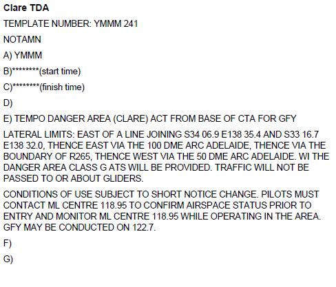
12 Note: CLARE and BURRA releases have a westerly boundary which is a straight line between Latitude/Longitude grid reference points. More care is necessary to remain within airspace. A CLARE release automatically includes BURRA to the east. RHYNIE ends here The SW corner of the CLARE area is aligned with the NW corner of RHYNIE area.
13

.")
14 NOTAMs How to get the NOTAMs: Step 1 Log on Go to the the airservices website and log on Register for free to create your own log on if you don t have one already. Step 2 Select our area Click on Area Briefing (second item on the Briefing list on the left) Select area 50 by typing 9500 into the first box or clicking on area 50 on the map Tick the NOTAM box and untick the Met box unless you also want weather info. Set the validity to a suitable time period, eg, 12 hours (default is 24 hours). Step 3 Interpretation Time The Notam information uses UTC time In winter the offset to Adelaide is hours In summer the offset to Adelaide is hours (when Daylight Savings is in effect) There are many world clock websites that will convert UTC to local time Maths in base 24 with a half hour time difference is error prone Note that dates change at midnight UTC and needs to be taken into account See Appendix for time and date conversion chart, and below for an example: Let s look at time format in more detail So in this example R265B is ACTIVE from 3,500 to FL240 between the period October 23 21:30 to October 28 06:30 (UTC time) Then we see to Converting to local Adelaide time since we are in daylight savings in this period (CDT): 21:30 UTC is 8:00 in the morning on the following day the 24 th October. Similarly 12:30 UTC on the 24 th is 23:00 CDT on the same day. So therefore R265B is active on Monday 24 th October from 8:00 in the morning through to 23:00 in the evening. Similarly also on Tuesday through Thursday, but deactivating on Friday at 06:30 UTC or 17:00 local time.
15 There are a couple of ways to get caught out here: 1. A date and time given in UTC may be the following day in Adelaide! 2. Daylight saving time needs to be considered. In summer we are another hour ahead of UTC. Use things to help you work it out like the conversion chart shown hereunder. Double check your calculations, be diligent. Ensure you have a clear picture of airspace before you take off. The Friday evening 24hr NOTAM may no longer be relevant if you come out on Saturday morning. Check NOTAM as close to your takeoff time as is practical. So this is what it all looks like on the PC screen once you ve logged in (with interpretation notes): Select Area Briefing, this is the best option to get the full picture for all airspace. The Restricted Area Briefing has the risk of not giving you the full airspace picture Note Australia is divided into two Flight Information Regions (FIR), Brisbane and Melbourne designated by the red boundary running diagonally across Australia Our area is You can type it into the box below or click on the sector on the map. Unselect the Met unless you also want weather info also. Choosing 12hrs gives info for the day only so makes matters more simple. Choosing 24hrs will provide 2 days info, so more UTC time calcs! Ensure the time selected covers the time you intend on flying. Check as close to launch or takeoff as possible Note the thin line running diagonally across Australia. This divides the airspace into a Northern region called the Brisbane Flight Information Region (FIR) or YBBB FIR and a Southern Melbourne FIR or YMMM. Commercial and general aviation traffic control responsibility lies with Brisbane or Melbourne, depending on which of these two regions you happen to be in. This is why you will see Melbourne (MEL) frequency references on Adelaide charts, in the event you are a general aviator travelling cross country you will likely be talking to a Melbourne based controller at some point. Now, back to the briefing:
16 This briefing was prepared for Hank and notes the 24hr period selected based on when the login occurred. It has no bearing on the validity of the airspace and times given in the NOTAM, other than to confirm that there is stuff going on over the time period selected. The first information lists NOTAMS by airport. This will be of interest if you intend on flying into one of these locations (LSA or GA pilots). Keep scrolling down for AIRSPACE specific information The information under this heading provides NOTAMs relevant to the airspace within the Edinburgh Military Airspace (EDX). This is generally most of what you can see on the VNC chart, but note there is also ENX (Edinburgh North Airspace) further afield. This information refers to the R265B airspace sector within EDX, remembering this is an altitude band marked by lateral limits. Shown is a list of dates and times when this airspace is ACTIVE. Information is provided in Universal Coordinating Time (UTC), therefore must be converted to local time to make sense to us in Adelaide (see later on). This is typically what you may see for a weekday NOTAM. This identifies the lateral boundaries of the airspace which is subject to the clearance. It is the EUDUNDA gliding release. This gives the date and time during which the clearance applies. Note it is in UTC time, the global aviation standard. To work out what this means to you in local time you have to convert it to local time. Also note that a late evening UTC time may be the following day in local time. This identifies the altitude limits. R265A is the airspace within EDX from lower limit 4500 up to NOTAM, meaning the upper limit will be advised as needed. So therefore, within the lateral limits of EUDUNDA we can fly up to an altitude limit of 6500.

17 So, in summary for the information above This release is provided within RESTRICTED AIRSPACE (military). This IS what you might typically see during the week when the RAAF are at work. Period of validity for this briefing in local time is 19:49 Monday evening the 24 th to 19:49 Tues 25 th [0919 UTC Oct 24 to 0919 UTC Oct 25]. This is by virtue only of the time Hank logged in to receive the NOTAM. The 24hr report was selected, but there is also a 12hr option available. Looking at the EDX airspace you will see a schedule of when this airspace is ACTIVE to This naming convention means 2016 October 23 21: October 24 12:30 (all in UTC still) 2016 October 24 08: October 24 23:00 (converted to local CDT time) See a similar pattern from Monday to Thursday Note on Friday the RAAF downs tools at , so from 17:00 CDT R265B is no longer active. On WEEKENDS, where restricted military airspace is usually not active, the airspace arrangements become an entirely civilian matter. A CTA RELEASE would then detail any special gliding airspace made available and provides access into what would otherwise be Class C controlled airspace. The templates for NOTAM publication are the same, but since it s not a release provided in restricted military airspace, we need to look for it under civilian airspace. Since we fall under the Melbourne FIR (YMMM), this is where you will find it. Keep scrolling down until you see Melbourne FIR: TARLEE release to 6500 on Saturday from 10:30 17:30 local time in Summer (CDT) Tip - Mark your charts for easy reference in reading NOTAMs and also for inflight reference EUDUNDA release to 6,500 on Sunday from 10:30 17:30 local time in Summer (CDT) Since 24hrs was selected information for both Saturday and Sunday is shown. Make sure you know what applies when you are going to fly!
18 LSA or GA pilots chasing the $100 hamburger on a Saturday morning may wish to know about these events. Parachute Jumping Exercise within 1nm radius of (grid reference Leconfield Winery), approximate on a bearing of 30 degrees and 4.25nm from Aldinga airport. From the surface to FL140 from February 4 th ongoing What if I can t find any release information? Where there is no gliding airspace release identified in the NOTAM, this simply means no special arrangement has been made to facilitate soaring flight into Class C airspace. The most likely cause of this is a poor long range weather forecast or weather unsuitable to soaring at high altitudes, such as through winter. Therefore we would conduct operations up to the lower limits (LL) of class C airspace. Any aircraft wanting to enter Class C airspace must have a specific Airways Clearance before doing so, as was discussed prior. The very bottom end of the NOTAM will show a list of airspace sectors that are not currently active, and this serves as a quick and convenient way to quickly determine the general status. If you saw Edinburgh Airspace (EDX) listed here then you know that the local Gawler airspace control is civilian. This quite often occurs on weekends. ENX and Other Airspace For those wishing to travel further afield than the EDX restricted military airspace and the Northern chart boundaries of the Adelaide VNC chart, it is worth familiarising with the ENX and other airspace groups. This can be found at the Restricted Area Briefing tab just after login (see below). For the more ambitious cross country pilots out there, your planning should include familiarisation where these areas are and whether your planned flights will take you near to, or over them. However, a word of caution here. This particular function WILL NOT provide all of the necessary information which you require to maintain airspace awareness. Use it ONLY as a guide for which areas are active, then refer to the full NOTAM as above for specific information.
19 2. In this example ENX has been entered as the Restricted Area of interest 1. Select this tab for general information on which areas are active. The airspace groups which form part of ENX are listed with a status indication. Whilst this is a useful tool to consult, you should always use the full area briefing to ensure you get all the relevant information for your flight. There is no information about times active for example.

20 Had we selected EDX, the following is listed with status indication. These groups are of most interest to those flying in and around Gawler airfield. You must consult the full NOTAM to ensure you get all the information. A good source of information is the Airservices Designated Airspace Handbook, which is available on the Airservices website as a free download. Ensure you have the most current version since they are updated every 6 months or so. Time Conversion Table Suggested reading Airservices Designated Airspace Handbook (DAH) [available as a pdf download from the website. Check for a current version, there are 6 monthly updates] GFA Airways & Radio Procedures (OPS 0005) [available as a download from the GFA website] Information compiled by: Hank Delen, GFA L2 Instructor Assisted by Peter Temple, ASC Airspace Officer ASC Instructor panel members
Gliding Federation of Australia
 Gliding Federation of Australia 37 th Club and Sports Class Championship 2017 Local rules Version 1.1 1 Part A Competition 1. Location Goondiwindi Aerodrome, Goondiwindi, Queensland 2. Dates Official practice
Effective: AUSTRALIAN INTERNATIONAL AIRSHOW AVALON 2019, AVALON AIRPORT 19 FEBRUARY - 5 MARCH 2019, AVALON EAST (YAVE) OPERATIONS
 OPERATIONS") AUSTRALIA AERONAUTICAL INFORMATION SERVICE AIRSERVICES AUSTRALIA GPO BOX 367, CANBERRA ACT 2601 Phone: 02 6268 4874 Email: aim.editorial@airservicesaustralia.com Effective: AIP SUPPLEMENT (SUP) H 01/19
AUSTRALIA AERONAUTICAL INFORMATION SERVICE AIRSERVICES AUSTRALIA GPO BOX 367, CANBERRA ACT 2601 Phone: 02 6268 4874 Email: aim.editorial@airservicesaustralia.com Effective: AIP SUPPLEMENT (SUP) H 01/19
Effective: AUSTRALIAN INTERNATIONAL AIRSHOW AVALON 2019, AVALON AIRPORT 19 FEBRUARY - 5 MARCH 2019, IFR OPERATIONS AVALON AIRPORT
 AUSTRALIA AERONAUTICAL INFORMATION SERVICE AIRSERVICES AUSTRALIA GPO BOX 367, CANBERRA ACT 2601 Phone: 02 6268 4874 Email: aim.editorial@airservicesaustralia.com Effective: AIP SUPPLEMENT (SUP) H 02/19
LETTER OF AGREEMENT. Between. and RELATING TO
 LETTER OF AGREEMENT Between NATS (En Route) plc, Scottish Area Control (Prestwick) NATS (Services) Ltd, Edinburgh ATC NATS (Services) Ltd, Glasgow ATC and BRITISH GLIDING ASSOCIATION (BGA) RELATING TO
SAFETYSENSE LEAFLET AIR TRAFFIC SERVICES OUTSIDE CONTROLLED AIRSPACE
 SAFETYSENSE LEAFLET 8e AIR TRAFFIC SERVICES OUTSIDE CONTROLLED AIRSPACE 1 INTRODUCTION 2 NON-RADAR SERVICES 3 RADAR SERVICES 4 HOW TO OBTAIN A SERVICE 5 RADAR SERVICE LIMITATIONS 1 INTRODUCTION a) In this
2015 VICTORIAN STATE GLIDING CHAMPIONSHIPS BENDIGO GLIDING CLUB RAYWOOD. 29 November to 6 December 2014 LOCAL INFORMATION & PROCEDURES
 2015 VICTORIAN STATE GLIDING CHAMPIONSHIPS BENDIGO GLIDING CLUB RAYWOOD 29 November to 6 December 2014 LOCAL INFORMATION & PROCEDURES 1. ORGANISERS The organisers of the 2015 Victorian State Gliding Championships
Effective: AUSTRALIAN FORMULA ONE GRAND PRIX, ALBERT PARK, MARCH 2018
 AUSTRALIA AERONAUTICAL INFORMATION SERVICE AIRSERVICES AUSTRALIA GPO BOX 367, CANBERRA ACT 2601 Phone: 02 6268 4874 Email: aim.editorial@airservicesaustralia.com Effective: AIP SUPPLEMENT (SUP) H 25/18
USE OF RADAR IN THE APPROACH CONTROL SERVICE
 USE OF RADAR IN THE APPROACH CONTROL SERVICE 1. Introduction The indications presented on the ATS surveillance system named radar may be used to perform the aerodrome, approach and en-route control service:
Contents. Subpart A General 91.1 Purpose... 7
 Contents Rule objective... 3 Extent of consultation... 3 Summary of comments... 4 Examination of comments... 6 Insertion of Amendments... 6 Effective date of rule... 6 Availability of rules... 6 Part 91
GAWLER AIRFIELD OPERATIONAL GUIDELINES
 By-Law 7 GAWLER AIRFIELD OPERATIONAL GUIDELINES Applicability This document replaces all other documents relating to flying operations at the Gawler Airfield. It takes effect from 26/04/2016. These guidelines
CLASS D CONTROLLED AIRSPACE GUIDE
 CLASS D CONTROLLED AIRSPACE GUIDE Introduction Norwich International Airport is surrounded by Class D Controlled Airspace (CAS). This airspace is made up of a Control Zone (CTR) and a Control Area (CTA).
CLASS D CONTROLLED AIRSPACE GUIDE
 CLASS D CONTROLLED AIRSPACE GUIDE Introduction Norwich International Airport is surrounded by Class D Controlled Airspace (CAS). This airspace is made up of a Control Zone (CTR) and a Control Area (CTA).
Devon and Somerset Gliding Club Notes on NOTAMs and SPINE interpretation software
 Devon and Somerset Gliding Club Notes on NOTAMs and SPINE interpretation software This document is intended to provide some background information on NOTAM information, as relevant to gliding in the UK,
CLEARANCE INSTRUCTION READ BACK
 CLEARANCE INSTRUCTION READ BACK 1. Introduction An ATC clearance or an instruction constitutes authority for an aircraft to proceed only in so far as known air traffic is concerned and is based solely
UK MOUNTAIN WAVE FESTIVAL - TRA (G) CAIRNGORM GLIDING CLUB
 CAIRNGORM GLIDING CLUB") AIRSPACE CO-ORDINATION NOTICE Safety and Airspace Regulation Group ACN Reference: Version: Date: Date of Original 2016-04-0110 V2.0 05 May 2016 22 April 2016 UK MOUNTAIN WAVE FESTIVAL - TRA (G) CAIRNGORM
AIRSPACE CO-ORDINATION NOTICE Safety and Airspace Regulation Group ACN Reference: Version: Date: Date of Original 2016-04-0110 V2.0 05 May 2016 22 April 2016 UK MOUNTAIN WAVE FESTIVAL - TRA (G) CAIRNGORM
VFR PHRASEOLOGY. The word IMMEDIATELY should only be used when immediate action is required for safety reasons.
 VFR PHRASEOLOGY 1. Introduction 1.1. What is phraseology? The phraseology is the way to communicate between the pilot and air traffic controller. This way is stereotyped and you shall not invent new words.
CHAPTER 5 SEPARATION METHODS AND MINIMA
 CHAPTER 5 SEPARATION METHODS AND MINIMA 5.1 Provision for the separation of controlled traffic 5.1.1 Vertical or horizontal separation shall be provided: a) between IFR flights in Class D and E airspaces
Class Alpha. In addition, if you fly above FL240 your aircraft must have DME or a suitable RNAV system.
 Go For It Class Alpha Class A airspace is from 18,000 feet MSL to Flight Level 600 (60,000 feet pressure altitude). Its lateral extent includes the contiguous U.S. and Alaska, and extends 12 nm from the
Advisory Circular AC61-3 Revision 12 SUPERSEDED Describe the duties of the pilot-in-command, as laid down in CA Act 1990 S13 and 13A.
 Subject No 4 Air Law Each subject has been given a subject number and each topic within that subject a topic number. These reference numbers will be used on knowledge deficiency reports and will provide
FLIGHT ADVISORY WASHINGTON D.C. SPECIAL FLIGHT RULES AREA LEESBURG MANUVERING AREA
 FLIGHT ADVISORY WASHINGTON D.C. SPECIAL FLIGHT RULES AREA LEESBURG MANUVERING AREA EFFECTIVE October 11, 201609 0400 This Notice does not supersede restrictions pertaining to the use of airspace contained
Yorkshire Gliding Club
 Yorkshire Gliding Club Notes for Visiting Pilots Extracts from Club Rules and Operating Procedures ~ 1. Introduction Welcome to the Yorkshire Gliding Club at Sutton Bank. The club has operated from this
NDS Subject to NOTAM: No
 AIRSPACE CO-ORDINATION NOTICE Safety and Airspace Regulation Group ACN Reference: Version: Date: Date of Original 2017-00-0131 1.1 29 November 2016 29 November 2016 RAF VALLEY (MONA) MSSR CALIBRATION NDS
Any queries about the content of the attached document should be addressed to: ICAO EUR/NAT Office:
 Serial Number: 2018_005 Subject: Special Procedures For In-Flight Contingencies in Oceanic Airspace Originator: NAT SPG Issued: 17 DEC 2018 Effective:28 MAR 2019 The purpose of this North Atlantic Operations
SPORT AVIATION CORP LTD
 SPORT AVIATION CORP LTD RECREATIONAL PILOT WRITTEN EXAMINATION Subcategory: Microlight No. 1 AIR LAW This examination paper remains the property of SAC Ltd and is protected by copyright. Name of Applicant:
IVAO Flight Operations Department Indonesia (ID) Division Procedures
 Division Procedures") IVAO Flight Operations Department Indonesia (ID) Division Procedures Revised April 12 rd, 2010 Please consult also the local application of common procedures on http://www.ivao.web.id 1. General 1.1 In
IVAO Flight Operations Department Indonesia (ID) Division Procedures Revised April 12 rd, 2010 Please consult also the local application of common procedures on http://www.ivao.web.id 1. General 1.1 In
Number April 2016
 Luxembourg Air Safety Bulletin Number 16-001 - April 2016 This Air Safety Bulletin examines a number of hazards related to flying in and out, and in the vicinity of, Luxembourg Airport. As the Direction
NAVIGATION: CHARTS, PUBLICATIONS, FLIGHT COMPUTERS (chapters 7 & 8)
") NAVIGATION: CHARTS, PUBLICATIONS, FLIGHT COMPUTERS (chapters 7 & 8) LONGITUDE AND LATITUDE 1. The location of an airport can be determined by the intersection of lines of latitude and longitude. a. Lines
NAVIGATION: CHARTS, PUBLICATIONS, FLIGHT COMPUTERS (chapters 7 & 8) LONGITUDE AND LATITUDE 1. The location of an airport can be determined by the intersection of lines of latitude and longitude. a. Lines
A Letter of Agreement Between: Robin Hood Airport Doncaster Sheffield and British Gliding Association
 A Letter of Agreement Between: Robin Hood Airport Doncaster Sheffield and British Gliding Association Contents Part Subject Page Introduction: Title Page and Signatures 2 PART ONE: Definitions of the Airspace
AIRSPACE STRUCTURE. In aeronautics, airspaces are the portion of the atmosphere controlled by a country above its territory.
 AIRSPACE STRUCTURE 1. Introduction In aeronautics, s are the portion of the atmosphere controlled by a country above its territory. There are two kinds of : Controlled is of defined dimensions within which
NAIPS Internet Service Authorised NOTAM Originator User Guide Version 3.0. (To be read in addition to NIS User Guide 3.0)
") NAIPS Internet Service Authorised NOTAM Originator User Guide Version 3.0 (To be read in addition to NIS User Guide 3.0) User Guide for Authorised NOTAM Originators Version 3.0 1. Introduction... 3 1.1
NAIPS Internet Service Authorised NOTAM Originator User Guide Version 3.0 (To be read in addition to NIS User Guide 3.0) User Guide for Authorised NOTAM Originators Version 3.0 1. Introduction... 3 1.1
Introduction. Appendix D: Airspace Protection
 Preliminary PreliminaryDraft DraftMaster MasterPlan Plan Bankstown Airport Introduction : Airspace Protection D Preliminary Master Plan Draft Master Plan Airspace protection D1 OVERVIEW The protection
Class B Airspace. Description
 Class B Airspace Ref. AIM 3-2-3 and FAR 91.131 Surrounds certain large airports Within each Class B airspace area, there are multiple segments with different ceiling/floor altitudes. Example: 70/30 = ceiling
LETTER OF AGREEMENT LETTER OF AGREEMENT BETWEEN LONDON SOUTHEND AIRPORT AND STOKE AIRFIELD
 LETTER OF AGREEMENT BETWEEN LONDON SOUTHEND AIRPORT AND STOKE AIRFIELD LOA LSA/ Stoke Airfield Version 1.1 Page 1 of 11 Date: 16 July 2014 Letter of Agreement Between London Southend Airport and Stoke
ALTIMETER SETTING PROCEDURES
 AIP New Zealand ENR 1.7-1 ENR 1.7 ALTIMETER SETTING PROCEDURES 1 INTRODUCTION 1.1 General 1.1.1 The requirements for altimeter setting are detailed in CAR Part 91. The requirements are summarised in this
Good radio calls not only sound professional, they help ATC and alleviate stress in the cockpit!
 Radio Calls Good radio calls not only sound professional, they help ATC and alleviate stress in the cockpit! What ATC need to know: This is easy; all ATC want is your intentions, your position (if applicable),
AIRSPACE CO-ORDINATION NOTICE Safety and Airspace Regulation Group ACN Reference: Version: Date: Date of Original
 AIRSPACE CO-ORDINATION NOTICE Safety and Airspace Regulation Group ACN Reference: Version: Date: Date of Original 2016-06-0532 V2 15 June 2016 15 June 2016 BRITISH GLIDING ASSOCIATION : COMPETITIONS 2016
Effective: AUSTRALIAN INTERNATIONAL AIRSHOW AVALON 2019, AVALON AIRPORT 19 FEBRUARY - 5 MARCH 2019, VFR OPERATIONS AVALON AIRPORT
 AUSTRALIA AERONAUTICAL INFORMATION SERVICE AIRSERVICES AUSTRALIA GPO BOX 367, CANBERRA ACT 2601 Phone: 02 6268 4874 Email: aim.editorial@airservicesaustralia.com Effective: AIP SUPPLEMENT (SUP) H 03/19
2017 Queensland State Gliding Competition
 2017 Queensland State Gliding Competition Warwick Aerodrome 30th September 7 th October 2017 Pilot Briefing Sheet General information about the competition that you should know before you arrive Location
FLASHCARDS AIRSPACE. Courtesy of the Air Safety Institute, a Division of the AOPA Foundation, and made possible by AOPA Holdings Company.
 AIRSPACE FLASHCARDS Courtesy of the Air Safety Institute, a Division of the AOPA Foundation, and made possible by AOPA Holdings Company. The Air Safety Institute is dedicated to making flying easier and
Chapter 9 - Airspace: The Wild Blue, Green & Red Yonder
 I5 Class G Airspace 38. [I4/3/3] What minimum visibility and clearance from clouds are required for VFR operations in Class G airspace at 700 feet AGL or lower during daylight hours? A. mile visibility
IFR SEPARATION WITHOUT RADAR
 1. Introduction IFR SEPARATION WITHOUT RADAR When flying IFR inside controlled airspace, air traffic controllers either providing a service to an aircraft under their control or to another controller s
GENERAL INFORMATION Aircraft #1 Aircraft #2
 GENERAL INFORMATION Identification number: 2007075 Classification: Serious incident Date and time 1 of the 2 August 2007, 10.12 hours occurrence: Location of occurrence: Maastricht control zone Aircraft
Safety Brief. 21st March Operations in Somali Airspace
 Safety Brief 21st March 2017 Operations in Somali Airspace Background IATA is aware of safety reports detailing various high risk events related to operations within the Mogadishu (Somalia) FIR (HCSM).
APPENDIX F AIRSPACE INFORMATION
 APPENDIX F AIRSPACE INFORMATION Airspace Use DEFINITION OF AIRSPACE Airspace, or that space which lies above a nation and comes under its jurisdiction, is generally viewed as being unlimited. However,
1.2 An Approach Control Unit Shall Provide the following services: c) Alerting Service and assistance to organizations involved in SAR Actions;
 Alerting Service and assistance to organizations involved in SAR Actions;") Section 4 Chapter 1 Approach Control Services Approach Control Note: This section should be read in conjunction with Section 2 (General ATS), Section 6 (Separation Methods and Minima) and Section 7 (ATS
Section 4 Chapter 1 Approach Control Services Approach Control Note: This section should be read in conjunction with Section 2 (General ATS), Section 6 (Separation Methods and Minima) and Section 7 (ATS
AUTOMATIC DEPENDENT SURVEILLANCE BROADCAST (ADS-B) IMPLEMENTATION IN INDONESIA
 IMPLEMENTATION IN INDONESIA") Phone/ Fax : 62 21 3507603 Telegraphic Address AFS : WRRRYNYX REPUBLIC OF INDONESIA MINISTRY OF TRANSPORTATION DIRECTORATE GENERAL OF CIVIL AVIATION DIRECTORATE OF AIR NAVIGATION SUB DIRECTORATE AERONAUTICAL
Phone/ Fax : 62 21 3507603 Telegraphic Address AFS : WRRRYNYX REPUBLIC OF INDONESIA MINISTRY OF TRANSPORTATION DIRECTORATE GENERAL OF CIVIL AVIATION DIRECTORATE OF AIR NAVIGATION SUB DIRECTORATE AERONAUTICAL
SPECIAL PROCEDURES FOR IN-FLIGHT CONTINGENCIES IN OCEANIC AIRSPACE OF SEYCHELLES FIR
 Phone: 248-4384186 AFS: FSIAYNYX FAX: 248-4384179 Email: sezais@scaa.sc REPUBLIC OF SEYCHELLES CIVIL AVIATION AUTHORITY AERONAUTICAL INFORMATION SERVICE P.O.BOX 181, VICTORIA SEYCHELLES AIP SUPPLEMENT
THIS BULLETIN REPLACES BULLETIN WHICH IS NO LONGER CURRENT AND HAS BEEN WITHDRAWN.
 IBAC Bulletin 16-03 THIS BULLETIN REPLACES BULLETIN 16-01 WHICH IS NO LONGER CURRENT AND HAS BEEN WITHDRAWN. Subject: Performance-based Navigation in Australian airspace - General guidance on the GNSS
Flying the VFR Coastal Route - Victor 1
 Flying the VFR Coastal Route - Victor 1 Preliminary information The information provided in these slides focusses on requirements relating to flying the Victor 1 coastal route, current at March 2013. The
Temporary Radio Mandatory Zone
 Introduction This safety notice contains a briefing and information about the establishment of Temporary airspace in the vicinity of Southend Airport in the form of a Radio Mandatory Zone (RMZ). The RMZ
REPUBLIC OF SEYCHELLES CIVIL AVIATION AUTHORITY AERONAUTICAL INFORMATION SERVICE P.O.BOX 181, VICTORIA SEYCHELLES
 Phone: 248-384000 AFS: FSIAYNYX FAX: 248-384030 Email: sezais@scaa.sc REPUBLIC OF SEYCHELLES CIVIL AVIATION AUTHORITY AERONAUTICAL INFORMATION SERVICE P.O.BOX 181, VICTORIA SEYCHELLES AIP SUPPLEMENT S02/09
CASCADE OPERATIONAL FOCUS GROUP (OFG)
") CASCADE OPERATIONAL FOCUS GROUP (OFG) Use of ADS-B for Enhanced Traffic Situational Awareness by Flight Crew During Flight Operations Airborne Surveillance (ATSA-AIRB) 1. INTRODUCTION TO ATSA-AIRB In today
CASCADE OPERATIONAL FOCUS GROUP (OFG) Use of ADS-B for Enhanced Traffic Situational Awareness by Flight Crew During Flight Operations Airborne Surveillance (ATSA-AIRB) 1. INTRODUCTION TO ATSA-AIRB In today
EASA NPA on SERA Part ENAV Response sheet. GENERAL COMMENTS ON NPA PACKAGE Note: Specific comments are provided after the General Comments
 EASA NPA on SERA Part ENAV Response sheet GENERAL COMMENTS ON NPA PACKAGE te: Specific comments are provided after the General Comments 1 SERA Parts C and D ENAV still misses clarity on the whole scope
Northern Regional Training Scheme. EGBB Birmingham Airport Pilot s Guide. REVISION 1 (Monday, 30 January 2012)
") Northern Regional Training Scheme EGBB Birmingham Airport Pilot s Guide REVISION 1 (Monday, 30 January 2012) PUBLISHED Monday, 30 January 2012 Contents Contents... 2 Section - 1 Departures... 3 1.1 Stand
Northern Regional Training Scheme EGBB Birmingham Airport Pilot s Guide REVISION 1 (Monday, 30 January 2012) PUBLISHED Monday, 30 January 2012 Contents Contents... 2 Section - 1 Departures... 3 1.1 Stand
4.2 AIRSPACE. 4.2 Airspace. Supplemental Draft Environmental Impact Statement August 2008 Military Training Activities at Mākua Military Reservation
 4.2 AIRSPACE 4.2.1 Impact Methodology Impacts on airspace use were assessed by evaluating the potential effects of the proposed training activities on the principal attributes of airspace use, as described
SECTION 6 - SEPARATION STANDARDS
 SECTION 6 - SEPARATION STANDARDS CHAPTER 1 - PROVISION OF STANDARD SEPARATION 1.1 Standard vertical or horizontal separation shall be provided between: a) All flights in Class A airspace. b) IFR flights
CAT E Subject to NOTAM: No
 AIRSPACE CO-ORDINATION NOTICE Safety and Airspace Regulation Group ACN Reference: Version: Date: Date of Original 2015-09-0091 V1.0 10 June 2016 10 June 2016 TALLA DVOR/DME CALIBRATION CAT E Subject to
AVIATION INVESTIGATION REPORT A00Q0116 RISK OF COLLISION
 Transportation Safety Board of Canada Bureau de la sécurité des transports du Canada AVIATION INVESTIGATION REPORT A00Q0116 RISK OF COLLISION BETWEEN AIR CANADA AIRBUS INDUSTRIE A319-114 C-FYJB AND CESSNA
THE VILLAGES AVIATION CLUB. SAFETY BRIEF November 2016
 THE VILLAGES AVIATION CLUB SAFETY BRIEF November 2016 Welcome Back Snowbirds When are you going home? If you see a man wearing a hat like this, go over and say Welcome Home. You ll make his day. Sure,
International Civil Aviation Organization REVIEW OF STATE CONTINGENCY PLANNING REQUIREMENTS. (Presented by the Secretariat) SUMMARY
 SUMMARY") BBACG/16 WP/4 31/01/05 International Civil Aviation Organization The Special Coordination Meeting for the Bay of Bengal area (SCM/BOB) and The Sixteenth Meeting of the Bay of Bengal ATS Coordination Group
BBACG/16 WP/4 31/01/05 International Civil Aviation Organization The Special Coordination Meeting for the Bay of Bengal area (SCM/BOB) and The Sixteenth Meeting of the Bay of Bengal ATS Coordination Group
MetroAir Virtual Airlines
 MetroAir Virtual Airlines NAVIGATION BASICS V 1.0 NOT FOR REAL WORLD AVIATION GETTING STARTED 2 P a g e Having a good understanding of navigation is critical when you fly online the VATSIM network. ATC
AIR LAW AND ATC PROCEDURES
 1 The International Civil Aviation Organisation (ICAO) establishes: A standards and recommended international practices for contracting member states. B aeronautical standards adopted by all states. C
Teaching the National Airspace System. Soaring Safety Foundation FIRC Presentation
 Teaching the National Airspace System Soaring Safety Foundation FIRC Presentation US Airspace Training Aids http://www.airnav.com Details of any airport http://www.skyvector.com On-line copies of sectional
Buttonville Flying Club
 Buttonville Flying Club 2833 16th Ave. Markham, ON L3R 0P8 Date: February 6, 2019 Subject: Mandatory Frequency Area at TORONTO Buttonville Municipal Airport (CYKZ) Procedures Executive Summary FOR VFR
Radio procedures for glider pilots August 2009
 Radio procedures for glider pilots August 2009 The use of radio is for aircraft to make calls to enhance the see and be seen environment, lookout is still the main weapon against collision but use of the
Pilot RVSM Training Guidance Material
 Pilot RVSM Training Guidance Material Captain Souhaiel DALLEL IFALPA RVP AFI WEST RVSM Pilot Procedures ICAO requires states to establish for flight crews specific: Initial training programs and Recurrent
Time: 1111Z Position: 5049N 00016W Location: 1nm SE Brighton City Airport
 AIRPROX REPORT No 2017181 Date: 29 Jul 2017 Time: 1111Z Position: 5049N 00016W Location: 1nm SE Brighton City Airport PART A: SUMMARY OF INFORMATION REPORTED TO UKAB Recorded Aircraft 1 Aircraft 2 Aircraft
Date: 01 Aug 2016 Time: 1344Z Position: 5441N 00241W
 AIRPROX REPORT No 2016157 Date: 01 Aug 2016 Time: 1344Z Position: 5441N 00241W Location: Langwathby PART A: SUMMARY OF INFORMATION REPORTED TO UKAB Recorded Aircraft 1 Aircraft 2 Aircraft AS365 King Air
AIRPROX REPORT No PART A: SUMMARY OF INFORMATION REPORTED TO UKAB
 AIRPROX REPORT No 2016061 Date: 28 Apr 2016 Time: 1135Z Position: 5047N 00314W Location: Exeter (EX) NDB hold PART A: SUMMARY OF INFORMATION REPORTED TO UKAB Recorded Aircraft 1 Aircraft 2 Aircraft C17
THE VILLAGES AVIATION CLUB. November 2014 SAFETY BRIEF
 THE VILLAGES AVIATION CLUB November 2014 SAFETY BRIEF IT WAS DARK, VERY DARK SO LETS GO FLYING SURE, YOU GET AN EXTRA HOURS SLEEP, BUT WHEN DO YOU GO FLYING? REVIEW OF NIGHT FLYING REGS AND TIPS Night
REPUBLIC OF SINGAPORE AERONAUTICAL INFORMATION SERVICES CIVIL AVIATION AUTHORITY OF SINGAPORE SINGAPORE CHANGI AIRPORT P.O. BOX 1, SINGAPORE
 AFS: WSSSYNYX caas_singaporeais@caas.gov.sg www.caas.gov.sg REPUBLIC OF SINGAPORE AERONAUTICAL INFORMATION SERVICES CIVIL AVIATION AUTHORITY OF SINGAPORE SINGAPORE CHANGI AIRPORT P.O. BOX 1, SINGAPORE
NATS Edinburgh / BGA LOA effective 24 November 2005
 Letter of Agreement NATS Edinburgh Air Traffic Control and British Gliding Association 1. General This Letter Of Agreement (LOA) is effective from the day that Edinburgh's revised Class 'D' Airspace is
DO NOT BEGIN THIS WORK UNTIL YOU HAVE COMPLETED ALL REQUIRED ASSIGNED READING AND EXERCISES.
 DO NOT BEGIN THIS WORK UNTIL YOU HAVE COMPLETED ALL REQUIRED ASSIGNED READING AND EXERCISES. Gardner Textbook Review Questions to prepare for Class #12 Answer these on notebook paper (or a text file) then
IRELAND AERONAUTICAL INFORMATION SERVICES IRISH AVIATION AUTHORITY CONTROL TOWER SHANNON AIRPORT
 IRELAND AIC AERONAUTICAL INFORMATION SERVICES IRISH AVIATION AUTHORITY Nr 10/02 CONTROL TOWER SHANNON AIRPORT 31 OCT CO. CLARE Tel +353 61 471954 Fax +353 61 471965 AFTN EINNYNYX OPERATIONS AT WESTON 1.
In our previous example for the circuit flight we have already learned how to ask for proper clearance so let's go.
 Learning Goals VFR R/T TRAINING VFR COMMUNICATION, HOW TO DO THIS (part 2) Since we have practised now a circuit flight, let's go over an example where we will do a flight from Borg El Arab (HEBA) to Alexandria
Pilot Procedures Photographic Survey Flights Flight Planning, Coordination, and Control
 Pilot Procedures Photographic Survey Flights Flight Planning, Coordination, and Control 2017-01-31 2017 NAV CANADA All rights reserved. No part of this document may be reproduced in any form, including
The Gliding Federation of Australia Now you re solo the next steps A, B and C Certificates
 The Gliding Federation of Australia Now you re solo the next steps A, B and C Certificates Name.. CONTENTS Now you re solo the next steps...1 A Certificate Specifications...3 Requirements...3 Privileges
DUXFORD AERODROME AIRSHOW PROCEDURES 2018
 DUXFORD AERODROME AIRSHOW PROCEDURES 2018 1 GENERAL 1.1 IWM Duxford s major events attract a variety of aircraft flown by pilots with wide ranging experience levels. This information is for ALL pilots
AERODROME OPERATIONS 1 INTRODUCTION
 AIP New Zealand AD 1.5-1 AD 1.5 AERODROME OPERATIONS 1 INTRODUCTION 1.1 General 1.1.1 This section details procedures for operations on and in the vicinity of aerodromes. 1.1.2 The layout of the circuit
NAIPS Internet Service User Guide Version 4.0
 NAIPS Internet Service User Guide Version 4.0 User Guide for NAIPS Internet Service (NIS) Version 4.0 1. Introduction... 4 1.1 Background... 4 1.2 References... 4 1.3 Connection - PC and Browser Setup...
 IFR 91.157 Must be instrument rated to fly special VFR at Night (civil twilight to civil twilight, sun 6 degrees below horizon) 91.159 Unless in a holding pattern of 2 minutes or less, VFR cruising altitude
SECTION 4 - APPROACH CONTROL PROCEDURES
 SECTION 4 - APPROACH CONTROL PROCEDURES CHAPTER 1 - PROVISION OF SERVICES 1.1 An approach control unit shall provide:- a) Approach control service. b) Flight Information service. c) Alerting service. RESPONSIBILITIES
The aim of any instrument approach is to allow the aircraft to safely descend to a low altitude in order to become visual.
 INSTRUMENT APPROACH CHARTS "An instrument approach is just a series of straight lines joined by rate one turns" Ron Magrath The aim of any instrument approach is to allow the aircraft to safely descend
SKUKUZA OPERATIONAL BRIEFING
 SKUKUZA OPERATIONAL BRIEFING To all pilots a) The following notice contains operational procedures when operating into and out of Skukuza airport. b) Please familiarise yourself with the instructions contained
FIT FOR PURPOSE: A Guide to Using NAV CANADA Aeronautical Publications SECTION B PUBLICATION SPECIFIC FIT FOR PURPOSE INFORMATION
 FIT FOR : A Guide to Using NAV CANADA Aeronautical Publications SECTION B PUBLICATION SPECIFIC FIT FOR INFORMATION I TABLE OF CONTENTS SECTION A: GENERAL MATERIAL 2 SECTION B: PUBLICATION SPECIFIC FIT
Private Pilot Checkride Oral Examination Preparation Guide
 Private Pilot Checkride Oral Examination Preparation Guide What documents are required to be on the glider? FAR 91. DOCUMENTS ON BOARD AIRCRAFT: [91.203(a)(1), 91.293(a)(2), FCC, 91.9(b),.91.103, Aircraft
Airspace Namibia 2017/18. Released Version
 Airspace Namibia 2017/18 Released Version 1.00 28.09.2017 Released Version 0.06 08.09.2017 Spelling error corrected 0,05 19.04.2017 South of FIR Windhoek 0.04 13.04.2017 After Meeting at Windhoek 0.03
AIRSPACE INFRINGEMENTS
 AIRSPACE INFRINGEMENTS Eurocontrol Airspace Infringements Workshop 24 January 2008 Dave Drake UK CAA Directorate of Airspace Policy The Problem Can lead to disruption to traffic Can lead to adverse economic
WARNING. South Australia Manual of Air Traffic Services Supplementary Procedures. Temporary amendments may apply. Procedure ATS-PROC-0003.
 South Australia Manual of Air Traffic Services Supplementary Procedures Procedure ATS-PROC-0003 Version 35 Effective 17 August 2017 Authorised: Operations Standards and Assurance Manager Airservices Australia
JAA Administrative & Guidance Material Section Five: Licensing, Part Two: Procedures
 090 00 00 00 COMMUNICATIONS 091 00 00 00 VFR COMMUNICATIONS 091 01 00 00 DEFINITIONS 091 01 01 00 Meanings and significance of associated terms x x x x x LO Stations LO Communication methods 091 01 02
PHRASEOLOGY COMMON MISTAKES
 1. How to read this manual PHRASEOLOGY COMMON MISTAKES This document is not a usual document that teaches only what to do, but this document will present the usual mistakes that every member can hear on
Date: 29 Jun 2018 Time: 1502Z Position: 5325N 00312W Location: 5nm NW Liverpool Airport
 AIRPROX REPORT No 2018158 Date: 29 Jun 2018 Time: 1502Z Position: 5325N 00312W Location: 5nm NW Liverpool Airport PART A: SUMMARY OF INFORMATION REPORTED TO UKAB Recorded Aircraft 1 Aircraft 2 Aircraft
distance and time to descend from a given level or altitude. LO Find the frequency and/or identifiers of radio-navigation aids from charts.
 Anne II to ED Decision 2016/008/R (1) For mass definitions, please refer to Chapter D. Syllabus 033 00 00 00 FLIGHT PLANNING AND MONITORING Aeroplane Helicopter / 033 01 00 00 FLIGHT PLANNING FOR VFR FLIGHTS
OPERATIONS MANUAL PART A
 PAGE: 1 Table of Content A.GENERAL /CHAPTER 7 -....3 7.... 3 7.1 Minimum Flight Altitudes /Flight Levels VFR Flight... 3 7.2 Minimum Flight Altitudes /Flight Levels IFR Flight... 4 7.2.1 IFR flights non
THE TOWER CONTROL POSITION (TWR)
") 1. Introduction THE TOWER CONTROL POSITION (TWR) The Aerodrome Local Control, or Tower (called TWR) controller has the responsibility of ensuring Air Traffic Control (ATC) Services within a restricted
1. Introduction THE TOWER CONTROL POSITION (TWR) The Aerodrome Local Control, or Tower (called TWR) controller has the responsibility of ensuring Air Traffic Control (ATC) Services within a restricted
Date: 29 Apr 2017 Time: 1119Z Position: 5226N 00112W Location: 10nm ENE Coventry
 AIRPROX REPORT No 2017080 Date: 29 Apr 2017 Time: 1119Z Position: 5226N 00112W Location: 10nm ENE Coventry PART A: SUMMARY OF INFORMATION REPORTED TO UKAB Recorded Aircraft 1 Aircraft 2 Aircraft C560 PA28
Standard Operating Procedures (SOPs) for UAE Centre (OMAE)
 for UAE Centre (OMAE)") Standard Operation Procedures for UAE Centre (OMAE) Pag.1 of 10 Standard Operating Procedures (SOPs) for UAE Centre (OMAE) Standard Operation Procedures for UAE Centre (OMAE) Pag.2 of 10 Index 1. Foreword...
Standard Operation Procedures for UAE Centre (OMAE) Pag.1 of 10 Standard Operating Procedures (SOPs) for UAE Centre (OMAE) Standard Operation Procedures for UAE Centre (OMAE) Pag.2 of 10 Index 1. Foreword...
CHAPTER 4 AIR TRAFFIC SERVICES
 CHAPTER 4 AIR TRAFFIC SERVICES 4.1 Objectives of the air traffic services 4.1.1 The objectives of the air traffic services shall be to: a) prevent collisions between aircraft; b) prevent collisions between
The NOTAM described will replace previously issued FDC NOTAMs 6/2550 and 7/7778 for the DC ADIZ/FRZ.
 This advisory covers published NOTAMs 7/0206 for the DC ADIZ, 7/0211 for the DC FRZ and FDC 7/0204 for the outer speed restriction. WARNING This document only contains an overview of the new rules for
helicopter? Fixed wing 4p58 HINDSIGHT SITUATIONAL EXAMPLE
 HINDSIGHT SITUATIONAL EXAMPLE Fixed wing or helicopter? Editorial note: Situational examples are based on the experience of the authors and do not represent either a particular historical event or a full