I3203 WORKSHEET. b. FMS procedure turn approach Selecting appropriate transition (example VOR RWY 08 at KPNS)
|
|
|
- Theodore Hubbard
- 5 years ago
- Views:
Transcription
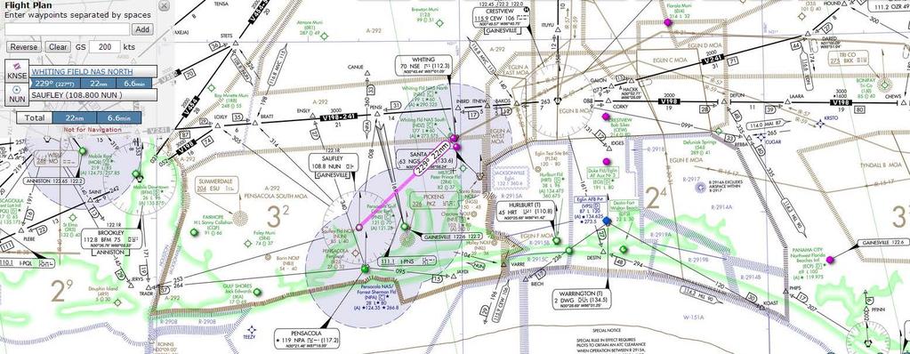
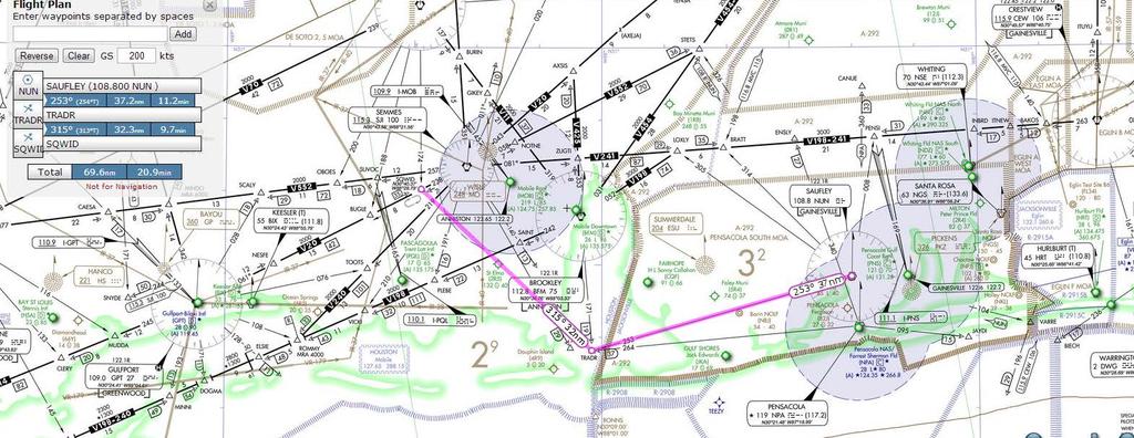
1 I3203 WORKSHEET Planned Route: Takeoff: Overhead KNSE Altitude: 16,000 Route: KNSE NUN Approaches: KNPA HI VOR RWY 19 KNPA RNAV (GPS) RWY 19 KPNS VOR RWY 8 Alternate: KMOB via NUN TRADR SQWID Approach: KMOB VOR-A (arcing) Prerequisites: -I3202, SY0302 Syllabus Notes: -None Special Syllabus Requirements: -None Discuss Items a. FMS HILO approach FAA rules for use of a published HILO pattern Selecting appropriate transition (example RNAV 14 at KNSE) o No transition selected o Transition requiring HILO selected o Transition with NoPT selected o HOLDING PAGE with IAF HILO waypoint exit type Automatic Retrievable only from approach database o HOLDING PAGE with Missed Approach holding waypoint Loaded from database along with approach b. FMS procedure turn approach Selecting appropriate transition (example VOR RWY 08 at KPNS) o No transition selected o Transition selected PDF source requirement for Final Approach Segment c. GPS approach FTI procedures d. RVFAC FTI procedures 1
2 Setting an intercept course in the FMS (example RNAV 11 at KMSY) e. FMS missed approach MISS APR selection o Prior to the MAWP o After the MAWP MISS APR automatic during loaded precision approach (ILS) 2
3 CNATRAINST B IUT T-6B RADIO INSTRUMENTS I3200 BLOCK IUT GRADE SHEET DATE INSTRUCTOR MEDIA: OFT/UTD VT- BRIEF TIME: NAME: EVENT: CTS MANEUVER REF MIF I3201 I GENERAL KNOWLEDGE / PROCEDURES 4+ X X X 2 EMERGENCY PROCEDURES 4+ X X X 3 HEADWORK / SITUATIONAL AWARENESS 4+ X X X 4 BASIC AIRWORK 4+ X X X 5 IN-FLIGHT CHECKS / FUEL MANAGEMENT 4+ X X X 6 IN-FLIGHT PLANNING / 4+ X X X AREA ORIENTATION 7 TASK MANAGEMENT 4+ X X X 8 COMMUNICATION 4+ X X X 9 MISSION PLANNING / BRIEFING / 4+ X X X DEBRIEFING 10 GROUND OPERATIONS 4 11 TAKEOFF 4+ X X 12 DEPARTURE 4+ X X 13 INSTRUCTIONAL SKILLS / STUNDENT 4+ X X X MANAGEMENT 41 STEEP TURNS 4 42 IFR UNUSUAL ATTITUDES 4 43 POINT-TO-POINT 4+ X 44 HOLDING 4+ X 45 ENROUTE PROCEDURES 4+ X X 46 ENROUTE DESCENT 4+ X X 47 HIGH-ALTITUDE APPROACH 4+ X 48 TEARDROP APPROACH 4+ X 49 ARCING APPROACH 4+ X 50 HILO APPROACH 4+ X 51 PROCEDURE TURN APPROACH 4+ X 52 RVFAC APPROACH 4+ X X 53 GPS APPROACH 4+ X X 54 PAR APPROACH 4+ X 55 ASR APPROACH 4+ X 56 VOR FINAL 4+ X X 57 ILS FINAL 4+ X 58 LOC FINAL 4+ X 59 GPS FINAL 4+ X 60 BACKUP FLIGHT INSTRUMENT APPROACH 4+ X 61 CIRCLING APPROACH 3+ X 62 MISSED APPROACH 4+ X X X 63 TRANSITION TO LANDING / LANDING 4+ X X X Syllabus Notes: I3201 shall be conducted in the OFT. I3202 and I3203 should be conducted in the OFT, but they may be conducted in the UTD. Discuss Items: I3201 Clearance and departure procedures, lost communications, local procedures/fih, and radar approaches. I3202 FMS flight plan usage, FMS SID, FMS STAR, FMS holding, and FMS arcing approach. I3203 FMS HILO approach, FMS procedure turn approach, GPS approach, RVFAC, and FMS missed approach B Rev 03/16/2017
4
5 SE-3, 19 JUL 2018 to 16 AUG 2018 SE-3, 19 JUL 2018 to 16 AUG 2018
6 SE-3, 19 JUL 2018 to 16 AUG 2018 SE-3, 19 JUL 2018 to 16 AUG 2018
7 P 7004 X 150 PENSACOLA, FLORIDA NUN VOR APP CRS Rwy Idg 7000 TDZE 97 Apt Elev 121 AL-318 (FAA) VOR RWY 8 PENSACOLA INTL(PNS) T A 3 Helicopter visbility reduction below 4 SM NA. CAUTION: Intensive student training invof airport. MISSED APPROACH: Climb to 2000 then climbing left turn to 2600 direct NUN VOR and hold. ATIS PENSACOLA APP CON PENSACOLA TOWER (CTAF) L GND CON CLNC DEL UNICOM PENSI CEW (19.5) 442 SE-3, 19 JUL 2018 to 16 AUG 2018 ELEV 121 R-269 TDZE IAF SAUFLEY NUN NUN MSANU N25NM SE-3, 19 JUL 2018 to 16 AUG A NM from FAF 8 P 7000 X150 P Remain within 10 NM 269 NUN VOR NUN 146 TWR P 0.3% UP REIL Rwys 8, 26 and 35 TDZ/CL Rwy 17 L HIRL Rwys 8-26 and L FAF to MAP 7.3 NM Knots Min:Sec 7:18 4:52 3:39 2:55 2:26 PENSACOLA, FLORIDA Amdt 4B 24JUL14 CATEGORY A B S (700-1) CIRCLING (700-1) 30 28'N-87 11'W 7.3 NM C D (700-2) (700-2) 679 ( ) PENSACOLA INTL(PNS) VOR RWY 8
8
9 15 R GCV Chan 104 MOBILE, ALABAMA VORTAC SJI Rwy Idg APP CRS TDZE Chan Apt Elev N/A N/A 219 AL-267 (FAA) VOR or TACAN-A MOBILE RGNL(MOB) T ASR MISSED APPROACH: Climb to 900, then climbing right turn to 2000 on heading 200 and SJI R-140 to SAINT INT/BFM 9.2 DME and hold. ATIS MOBILE APP CON MOBILE TOWER GND CON (CTAF) L CLNC DEL UNICOM MSA S J I25 NM 3100 R-284 (IF) TACCU SJI 7 IAF SEMMES SJI Chan 100 SE-4, 19 JUL 2018 to 16 AUG SJI Arc 1800 No PT (7) (IAF) SQWID SJI 7 R UBACE SJI R BROOKLEY BFM Chan 75 R-242 SE-4, 19 JUL 2018 to 16 AUG 2018 ELEV SAINT BFM 9.2 P A from FAF TWR NM 8502 X 150 H H P 4376 X H 36 x 283 x A Remain within 10 NM SJI VORTAC UBACE SJI 5.6 hdg 200 SJI R-140 SAINT MIRL Rwy HIRL Rwy FAF to MAP 5.6 NM Knots Min:Sec 5:36 3:44 2:48 2:14 1:52 MOBILE, ALABAMA Amdt 2A 29MAY14 CATEGORY A B C D C CIRCLING (500-1) 30 41'N-88 15'W 5.6 NM ( ) (600-2) MOBILE RGNL(MOB) VOR or TACAN-A
10 SE-3, 19 JUL 2018 to 16 AUG 2018 SE-3, 19 JUL 2018 to 16 AUG 2018
11 NEW ORLEANS, LOUISIANA WAAS CH W11A APP CRS 106 Rwy Idg TDZE Apt Elev AL-609 (FAA) RNAV (GPS) Y RWY 11 LOUIS ARMSTRONG NEW ORLEANS INTL(MSY) T For uncompensated Baro-VNAV systems, LNAV/VNAV NA below -1 C (31 F) or above 54 C (130 F). DME/DME RNP-0.3 NA. For inop ALSF-2, increase LNAV/VNAV all Cats visibility to RVR ALSF-2 A MISSED APPROACH: Climb to 2000 direct ZUBEL and on track 195 to SAFES and hold. D-ATIS NEW ORLEANS APP CON WEST EAST NEW ORLEANS TOWER GND CON CLNC DEL CPDLC MSA R W NM Procedure NA for arrivals on RQR VOR/DME airway radials 055 CW 082. (IAF) RESERVE RQR (IF) FIGUR SC-4, 19 JUL 2018 to 16 AUG (28.2) (3.8) (IAF) Procedure NA for arrivals TIBBY at TBD VOR/DME TBD on V westbound. ELEV 4 D TDZE (7.1) (FAF) KUSTE 259 WEKTA 1.4 NM to 156 RW11 83 RW SAFES ZUBEL (8.5) SC-4, 19 JUL 2018 to 16 AUG NM 106 to RW11 11 A 16 P X150 H H 85 P TWR P X A 4 X 20 P X 150 A GP 3.00 TCH 55 CATEGORY LPV FIGUR DA LNAV/ DA VNAV 106 A 2000 KUSTE ZUBEL SAFES WEKTA 1.4 NM to RW11 * NM 4.7 NM 1.4 NM B 204/18 C (200-2 ) 1 254/ (300-2 ) tr LNAV only. * RW11 D RLLS Rwy 2 TDZ/CL Rwy 11 HIRL All Runways NEW ORLEANS, LOUISIANA Amdt 2B 17AUG17 LNAV MDA 1 340/ (400-2 ) 5 340/ (400-8 ) C CIRCLING (600-1) ( ) 596 (600-2) LOUIS ARMSTRONG NEW ORLEANS INTL(MSY) 30 00'N-90 16'W RNAV (GPS) Y RWY 11
12 APPROACH TRANSITIONS The RNAV 14 approach is selected with no transition Press LSK R6 to view the resulting LEGS
13 APPROACH TRANSITIONS The IAF MERTY has no /H suffix The HILO holding pattern will not be displayed during the approach

14 APPROACH TRANSITIONS The RNAV 14 approach is selected with the MERTY transition Press LSK R6 to view the resulting LEGS
15 APPROACH TRANSITIONS The IAF MERTY has a /H suffix The HILO holding pattern will be displayed during the approach
16 APPROACH TRANSITIONS The RNAV 14 approach is selected with the PENSI transition This IAF has NoPT published enroute to MERTY Press LSK R6 to view the resulting LEGS
17 APPROACH TRANSITIONS MERTY has no /H suffix The HILO holding pattern will not be displayed during the approach (NoPT)
18 HOLD PAGE When an approach transition that uses a published HILO pattern is loaded the exit type is ONCE The second time the aircraft crosses the waypoint it will automatically resume normal sequencing.

19 HOLDING PAGE SHOWING MAP HOLDING FIX FROM DATABASE HILGA is a missed approach holding fix that is automatically loaded along with it s associated approach procedure : KHBG RNAV Z RWY 3 Exit type is MANUAL. Same as a user generated holding pattern. Once holding fix is crossed automatic waypoint sequencing is suspended until: EXIT is ARMED or NEW ACTICE WAYPOINT is selected
20 APPROACH TRANSITIONS The VOR RWY 8 approach is selected with the no transition Press LSK R6 to view the resulting LEGS
21 APPROACH TRANSITIONS Only the waypoints from the FAF inbound will be loaded from the database. All of the waypoints associated with the procedure turn will not be available.
22 APPROACH TRANSITIONS The VOR RWY 8 approach is selected with the PENSI transition Press LSK R6 to view the resulting LEGS

23 APPROACH TRANSITIONS With a transition selected, all the relative waypoints are included in the download from the approach database.
24 Radar Vectors to Final The FMS allows the user to select an intercept course to the FAWP. For orientation purposes it is beneficial to input the FAC as the intercept to display a track line along the FAC. This can be accomplished on the LEGS PAGE
25 Radar Vectors to Final Download the FAWP (KUSTE) into the scratchpad.

26 Radar Vectors to Final Upload the FAWP to the active waypoint position ( LSK L1 on PAGE 1)
27 Radar Vectors to Final At the LSK R6 position the FMS will display GPS computed course from the FAWP to the next waypoint in the sequence. This is the desired INTC CRS Note The GPS computes required courses using great circle routes vice the conventional NAVAID method. As a result This course may be slightly different from the course published on the approach plate. If needed a course can be manually entered via the scratchpad and uploaded using the LSK R6 key To verify the INTC CRS select LSK R6

28 Radar Vectors to Final Note that the FONT of the INTC CRS becomes slightly larger. Once the modification is made it will only become active when the EXEC button is selected on the UFCP.
29 Radar Vectors to Final After the change is activated return to the NAV PAGE.

30 Radar Vectors to Final Now a line extending outward from the FAWP can be seen and used for orientation during vextors to final.

31 Missed approach procedures Upon reaching the MAP (missed approach point), the FMS will not automatically sequence to, or display any follow-on missed approach waypoints. 125
32 Missed approach procedures After the MAP, course guidance along the FAC will continue to be provided by the FMS. Once initial missed approach actions are taken (two positive rates gear, above 110 flaps) the additional (follow-on) waypoints can be activated by selecting LSK LR (MIS APR) on the NAV PAGE. 126
33 Missed approach procedures Once MISS APR is activated, the FMS will display and sequence through any follow on waypoints normally. Here the display shows the need for a right turn to proceed direct to HILGA/H our missed approach holding point which is 15.1 nm behind us. 127

34 MISS APR If MISS APR is selected prior to reaching the MAWP the track lines to the follow-on waypoints will be displayed in white CDI scale will be reset to 1.0 nm for full scale. Selecting a larger range scale will allow all follow-on waypoints to be displyed.

35 MISS APR Approach integrity of.3 nm for the final segment is no longer available.
36 R AIM CHG 2 12/10/15 3/15/07 5/26/16 pilots operating properly equipped and airworthy aircraft in accordance with operating rules and procedures acceptable to the FAA. Special IAPs are also developed using TERPS but are not given public notice in the FR. The FAA authorizes only certain individual pilots and/or pilots in individual organizations to use special IAPs, and may require additional crew training and/or aircraft equipment or performance, and may also require the use of landing aids, communications, or weather services not available for public use. Additionally, IAPs that service private use airports or heliports are generally special IAPs. FDC NOTAMs for Specials, FDC T-NOTAMs, may also be used to promulgate safety-of-flight information relating to Specials provided the location has a valid landing area identifier and is serviced by the United States NOTAM system. Pilots may access NOTAMs online or through an FAA Flight Service Station (FSS). FSS specialists will not automatically provide NOTAM information to pilots for special IAPs during telephone pre flight briefings. Pilots who are authorized by the FAA to use special IAPs must specifically request FDC NOTAM information for the particular special IAP they plan to use Procedure Turn and Hold in lieu of Procedure Turn a. A procedure turn is the maneuver prescribed when it is necessary to reverse direction to establish the aircraft inbound on an intermediate or final approach course. The procedure turn or hold in lieu of PT is a required maneuver when it is depicted on the approach chart, unless cleared by ATC for a straight in approach. Additionally, the procedure turn or hold in lieu of PT is not permitted when the symbol No PT is depicted on the initial segment being used, when a RADAR VECTOR to the final approach course is provided, or when conducting a timed approach from a holding fix. The altitude prescribed for the procedure turn is a minimum altitude until the aircraft is established on the inbound course. The maneuver must be completed within the distance specified in the profile view. For a hold in lieu of PT, the holding pattern direction must be flown as depicted and the specified leg length/timing must not be exceeded. NOTE The pilot may elect to use the procedure turn or hold in lieu of PT when it is not required by the procedure, but must first receive an amended clearance from ATC. If the pilot is uncertain whether the ATC clearance intends for a procedure turn to be conducted or to allow for a straight in approach, the pilot must immediately request clarification from ATC (14 CFR Section ). 1. On U.S. Government charts, a barbed arrow indicates the maneuvering side of the outbound course on which the procedure turn is made. Headings are provided for course reversal using the 45 degree type procedure turn. However, the point at which the turn may be commenced and the type and rate of turn is left to the discretion of the pilot (limited by the charted remain within xx NM distance). Some of the options are the 45 degree procedure turn, the racetrack pattern, the teardrop procedure turn, or the 80 degree 260 degree course reversal. Racetrack entries should be conducted on the maneuvering side where the majority of protected airspace resides. If an entry places the pilot on the non maneuvering side of the PT, correction to intercept the outbound course ensures remaining within protected airspace. Some procedure turns are specified by procedural track. These turns must be flown exactly as depicted. 2. Descent to the procedure turn (PT) completion altitude from the PT fix altitude (when one has been published or assigned by ATC) must not begin until crossing over the PT fix or abeam and proceeding outbound. Some procedures contain a note in the chart profile view that says Maintain (altitude) or above until established outbound for procedure turn (See FIG ). Newer procedures will simply depict an at or above altitude at the PT fix without a chart note (See FIG ). Both are there to ensure required obstacle clearance is provided in the procedure turn entry zone (See FIG ). Absence of a chart note or specified minimum altitude adjacent to the PT fix is an indication that descent to the procedure turn altitude can commence immediately upon crossing over the PT fix, regardless of the direction of flight. This is because the minimum altitudes in the PT entry zone and the PT maneuvering zone are the same Arrival Procedures
37 5/26/16 12/10/15 AIM following systems qualify as a suitable RNAV system: 1. An RNAV system with TSO C129/ C145/ C146 equipment, installed in accordance with AC , Airworthiness Approval of Global Positioning System (GPS) Navigation Equipment for Use as a VFR and IFR Supplemental Navigation System, or AC A, Airworthiness Approval of Navigation or Flight Management Systems Integrating Multiple Navigation Sensors, and authorized for instrument flight rules (IFR) en route and terminal operations (including those systems previously qualified for GPS in lieu of ADF or DME operations), or 2. An RNAV system with DME/DME/IRU inputs that is compliant with the equipment provisions of AC A, U.S. Terminal and En Route Area Navigation (RNAV) Operations, for RNAV routes. A table of compliant equipment is available at the following website: headquarters_offices/avs/offices/afs/afs400/afs47 0/policy_guidance/ NOTE Approved RNAV systems using DME/DME/IRU, without GPS/WAAS position input, may only be used as a substitute means of navigation when specifically authorized by a Notice to Airmen (NOTAM) or other FAA guidance for a specific procedure. The NOTAM or other FAA guidance authorizing the use of DME/DME/IRU systems will also identify any required DME facilities based on an FAA assessment of the DME navigation infrastructure. c. Uses of Suitable RNAV Systems. Subject to the operating requirements, operators may use a suitable RNAV system in the following ways. 1. Determine aircraft position relative to, or distance from a VOR (see NOTE 5 below), TACAN, NDB, compass locator, DME fix; or a named fix defined by a VOR radial, TACAN course, NDB bearing, or compass locator bearing intersecting a VOR or localizer course. 2. Navigate to or from a VOR, TACAN, NDB, or compass locator. 3. Hold over a VOR, TACAN, NDB, compass locator, or DME fix. 4. Fly an arc based upon DME. NOTE 1. The allowances described in this section apply even when a facility is identified as required on a procedure (for example, Note ADF required ). 2. These operations do not include lateral navigation on localizer based courses (including localizer back course guidance) without reference to raw localizer data. 3. Unless otherwise specified, a suitable RNAV system cannot be used for navigation on procedures that are identified as not authorized ( NA ) without exception by a NOTAM. For example, an operator may not use a RNAV system to navigate on a procedure affected by an expired or unsatisfactory flight inspection, or a procedure that is based upon a recently decommissioned NAVAID. 4. Pilots may not substitute for the NAVAID (for example, a VOR or NDB) providing lateral guidance for the final approach segment. This restriction does not refer to instrument approach procedures with or GPS in the title when using GPS or WAAS. These allowances do not apply to procedures that are identified as not authorized (NA) without exception by a NOTAM, as other conditions may still exist and result in a procedure not being available. For example, these allowances do not apply to a procedure associated with an expired or unsatisfactory flight inspection, or is based upon a recently decommissioned NAVAID. 5. Use of a suitable RNAV system as a means to navigate on the final approach segment of an instrument approach procedure based on a VOR, TACAN or NDB signal, is allowable. The underlying NAVAID must be operational and the NAVAID monitored for final segment course alignment. 6. For the purpose of paragraph c, VOR includes VOR, VOR/DME, and VORTAC facilities and compass locator includes locator outer marker and locator middle marker. d. Alternate Airport Considerations. For the purposes of flight planning, any required alternate airport must have an available instrument approach procedure that does not require the use of GPS. This restriction includes conducting a conventional approach at the alternate airport using a substitute means of navigation that is based upon the use of GPS. For example, these restrictions would apply when planning to use GPS equipment as a substitute means of navigation for an out of service VOR that supports an ILS missed approach procedure at an alternate airport. In this case, some other approach not reliant upon the use of GPS must be available. This restriction does not apply to RNAV systems Performance Based Navigation (PBN) and Area Navigation (RNAV) 1 2 7
38 PRIMARY INSTRUMENT NAVIGATION T-6B CHAPTER TEN Procedure For the following example refer to the RNAV (GPS) RWY 32 at Gulfport-Biloxi Intl (see Figure 10-3). Little Dogs Dig Holes Always (LDDHA) is helpful mnemonic for FMS setup. In this example the bearing to IVOLE (the center IF/IAF) is between 043 and 133 and you have been Cleared for the RNAV RWY 32 approach. From this area you are expected to proceed direct to FAROR and may comply with the depicted TAA altitudes. Upon receiving approach clearance: 1. L Load GPS approach. (If not previously accomplished). NOTE Ensure that the appropriate approach transition is selected (FAROR in this example). Where opted, failing to select an appropriate transition will prevent needed waypoints from being loaded to the LEGS Page (IAF, /H (HILO), PT, Arcs or other approach options). 2. D Direct to IAWP, (in this case FAROR). NOTE If being radar vectored to final select FAF (VICKR) as the active waypoint and enter the FAC (313 ) as the Intercept course. Then comply with Radar Vector to Final Approach Course (RVFAC) procedures until cleared for the approach. 3. D Display PFD source should be set to FMS. 4. H Hold If the approach requires a turn in holding (HILO), ensure that the waypoint appears in the legs page with the /H suffix. 5. A Approach Mode Verify APR (approach) mode at 2NM from MAWP on PFD 6. Descend to appropriate altitude per TAA/ATC instructions (cleared for the approach and within 30 nm of FAROR descend to 2000 MSL). 7. Within 5 NM of the IAWP (FAROR), Slow to 150 KIAS. 8. Fly published procedure to establish aircraft inbound to the FAWP (VICKR). 9. Comply with courses and altitudes (use Turn anticipation where appropriate). GPS APPROACH PROCEDURES 10-9
39 CHAPTER TEN PRIMARY INSTRUMENT NAVIGATION T-6B NOTE In our example, maintain 2000ʹ MSL until FAFWP tracking 043 course from FAROR to the IF IVOLE, then 313 from IVOLE to FAWP VICKR (the published NoPT on this segment indicates that the published HILO pattern should not be executed). 10. Within 5 NM of the FAWP (VICKR) transition to BAC. NOTE Expect handoff to Tower or advisory frequency when inbound to the FAFWP. On initial contact, report position along the approach, gear status and your intentions. 11. At 3 NM from the FAWAP (VICKR) observe HSI SCALES TO CHANGE message. 12. At 2 NM from the FAWP (VICKR) observe transition to APR (approach) mode. NOTE If the FMS fails to transition to the APR MODE notify the Instructor and comply with Loss of GPS integrity prior to the FAWP procedures. 13. At the FAWP execute the 6T s: TIME - As required for any backup approach. TURN - Continue tracking FMS to the MAWP. TIME - Not required. TRANSITION - Set approximately 15% torque, trim for 120 KIAS descent to segment altitude or MDA as required (LNAV MDA 460 MSL). NOTE Adjust pitch to maintain airspeed; use power as required to maintain a stabilized rate of descent not to exceed 1000 fpm. TWIST - Track course from FAC to the MAWP (course is set by the FMS) GPS APPROACH PROCEDURES
40 PRIMARY INSTRUMENT NAVIGATION T-6B CHAPTER TEN NOTES 1. On some approaches, a course change may be required passing the FAWP. 2. Named waypoints on the published instrument approach between the FAWP and MAWP that can be defined using Along-Track-Distance (ATD) from the MAWP or other charted methods may not appear on the NAV/TSD display or on the LEGS page. TALK - As required/directed. NOTE If a GPS Integrity warning occurs between the FAWP and the MAWP, execute the Loss of GPS Integrity Inside the FAF procedures. 14. Approximately 100 prior to the MDA, slowly add power to arrest the rate of descent. 15. At the MDA (460 ), adjust power to maintain altitude and approach speed. 16. Fly at the MDA to the MAWP (RWY32). 17. Upon reaching the MAWP (RWY32), if the runway is not insight or the aircraft is not in a position to make a safe landing, execute the Missed Approach. NOTE The VDP for this approach is defined by distance from the MAWP (1.2 NM prior to RWY32) The FMS will NOT automatically sequence to any waypoints required for execution of the Missed Approach procedure. Automatic sequencing will cease at the MAWP. Once stabilized in the climb and clean, if a Missed Approach is required the pilot must manually sequence the system to the first Missed Approach WPT by selecting MISS APR and EXEC. Until MISS APR is selected the FMS will continue to provide course guidance along the FAC. Common Errors 1. Loading wrong approach/transition. 2. Inappropriate use of feeder fix/taa altitudes. 3. Not slowing to 150 KIAS within 5 NM of the IAWP (for non-radar vectors). GPS APPROACH PROCEDURES 10-11
41 CHAPTER TEN PRIMARY INSTRUMENT NAVIGATION T-6B 4. Late transition to BAC. 5. Not verifying APR mode within 2 NM of the FAWP. 6. Using wrong Minimums for the approach LOSS OF GPS INTEGRITY Prior to the FAWP: If a GPS integrity warning occurs prior to the FAWP, or system sensitivity does not change to APR mode within 2 NM of the FAWP: 1. Transition to a backup approach if available. NOTE This does not, for example, give the pilot the option to fly an ILS approach if the clearance given was to a stand-alone RNAV (GPS) approach. If however, the clearance given was to an overlay approach, the pilot may transition to the underlying NAVAID and continue on the approach. If no backup approach is available (or until obtaining clearance for one); 2. Continue on course to the FAWP. 3. At the FAWP continue to the MAWP maintaining the FAWP altitude. 4. At the MAP, execute the published Missed Approach or climbout instructions as appropriate. Inside the FAWP: NOTE Inform the controlling agency as soon as practical. A GPS integrity warning occurring after the FAWP is a serious situation. Pilots must be prepared to take immediate action. 1. Transition to your backup approach, if available (see note from step one above). 2. Climb to the Missed Approach altitude. 3. Continue tracking to the MAWP GPS APPROACH PROCEDURES
42 CHAPTER EIGHT PRIMARY INSTRUMENT NAVIGATION T-6B 819. RADAR VECTORS TO FINAL APPROACH COURSE (RVFAC) General Navigate to the final approach course following controller instructions. Description Radar vectors to final approach course is a procedure used by approach control to increase the arrival rate of aircraft by providing vectors onto the final approach course through the most expeditious routes consistent with traffic situations. Although this routing does expedite arrival at your destination, it has one characteristic of which you should be aware the lack of published minimum altitudes until joining a segment of a published approach. Approach control has the statutory responsibility for ensuring terrain clearance while vectoring you for the approach. This is done using Minimum Vectoring Altitude (MVA) charts superimposed on radar displays. Procedure NOTE Pilots should never fully relinquish the responsibility for terrain clearance to an outside agency. Maintain situational awareness and crosscheck terrain clearance altitude by using available NAVAIDS and charts. Never blindly follow vectors from a controller. Be aware of what lies ahead on your assigned heading. If in doubt, query the controller. Fly 200 KIAS on downwind and 150 KIAS on base. If being vectored on an extended final or extended dog-leg to final, maintain 200 KIAS until within 15 NM of the airport (Figure 8-16). 1. Tune and identify the appropriate NAVAID. 2. Check the PFD is configured properly. 3. Set the final approach course into the CDI. 4. Follow radar vectors given by approach control. 5. If a lower altitude is assigned, perform a terminal descent. 6. Transition to BAC: a. When within 5 NM of the FAF and aircraft heading is within 90º of the final approach course TERMINAL PROCEDURES
43 PRIMARY INSTRUMENT NAVIGATION T-6B CHAPTER EIGHT b. Once established on the FAC and cleared for the approach if no FAF is depicted. 7. When cleared for the approach, maintain the last assigned altitude and heading given by ATC until established on the approach. As the CDI begins to center, and you are cleared for the approach, you are expected to turn onto the final approach course and track inbound. 8. Once established inbound, comply with the remainder of the Low Altitude Instrument Approach Procedures. Common Errors 1. Poor orientation, loss of SA. 2. Not setting the correct NAV source in the PFD. 3. Failure to transition to BAC at the appropriate time. 4. Failure to intercept the approach course once cleared for the approach. Be alert for CDI movement and lead the turn sufficiently to roll out on course. Extended Dog-Leg to final 200 KIAS until 15 nm from airport Extended Straight-in 200 KIAS until 15 nm from airport Base leg 150 KIAS *Transition to BAC when 5 nm from the FAF and aircraft heading is within 90 of the FAC *If no FAF is depicted, transition to BAC when established on FAC and cleared for the approach Downwind 200 KIAS Figure 8-16 RVFAC (FAF Depicted) TERMINAL PROCEDURES 8-33
I3202 WORKSHEET / DD-175 / JET LOG
 I3202 WORKSHEET / DD-175 / JET LOG Planned Route: Takeoff: KHBG (Hattiesburg MUNI), RWY 13 Altitude: 8,000 Airspeed TAS as filed Destination: New Orleans INTL via LBY2.LBY LBY.RYTHM4 Approach: KMSY RVFAC
I3201 WORKSHEET / DD-175 / JET LOG
 Planned Route: I3201 WORKSHEET / DD-175 / JET LOG Takeoff: KNSE, RWY 32 Altitude: 6,000 Airspeed TAS as filed Destination: Monroeville County via Direct PENSI STETS V-454 MVC HOVEN Approach: KMVC RNAV
INSTRUMENT RATING STUDENT RECORD
 INSTRUMENT RATING STUDENT RECORD CHECK-IN AND ORIENTATION REQUIRED BEFORE FIRST FLIGHT!! TSA Documentation: Must keep photocopies of ALL in student s folder for 5 years. Student Name: US Citizen: Unexpired
Instrument Proficiency Check Flight Record
 Instrument Proficiency Check Flight Record Date: Flight Time: Sim. Inst. Time: Pilot Name: Aircraft Type: Aircraft Tail Number: Act. Inst. Time: Instructor Name: Holding Procedures Task Notes N/A Satisfactory
I3203 WORKSHEET / DD-175 / JETLOG
 I3203 WORKSHEET / DD-175 / JETLOG Planned Route: Takeoff: Mobile Regional KMOB RWY 14 Altitude: 5,000 Airspeed Max Cruise Power or filed TAS whichever is less. Destination: Navy Pensacola KNPA via SAINT
APPENDIX B DRO INSTRUMENT APPROACH CHARTS & DEPARTURE PROCEDURES
 APPENDIX B INSRUMEN APPROACH CHARS & DEPARURE PROCEDURES DURANGO, COLORADO LOC I- Rwy Idg APP CRS DZE 09. Apt Elev 920 668 6685 AL-480 (FAA) ILS or LOC/DME RWY DURANGO-LA PLAA COUNY() DME from VOR/DME.
EXPLANATION OF TPP TERMS AND SYMBOLS
 U.S. TERMINAL PROCEDURES PUBLICATION 52 EXPLANATION OF TPP TERMS AND SYMBOLS The discussions and examples in this section will be based primarily on the IFR (Instrument Flight Rule) Terminal Procedures
Chapter 6. Nonradar. Section 1. General DISTANCE
 12/10/15 JO 7110.65W Chapter 6. Nonradar Section 1. General 6 1 1. DISTANCE Use mileage based (DME and/or ATD) procedures and minima only when direct pilot/controller communications are maintained. FIG
 IFR 91.157 Must be instrument rated to fly special VFR at Night (civil twilight to civil twilight, sun 6 degrees below horizon) 91.159 Unless in a holding pattern of 2 minutes or less, VFR cruising altitude
Single Engine Instrument Training Record I PREFLIGHT PREPARATION WEATHER INFORMATION weather reports and forecasts. pilot and radar reports.
 Single Engine Instrument Training Record I PREFLIGHT PREPARATION WEATHER INFORMATION weather reports and forecasts. pilot and radar reports. surface analysis charts. radar summary charts. significant weather
2007 Instrument Procedures Handbook; Chapter 5 Approach
 2007 Instrument Procedures Handbook; Chapter 5 Approach Authors: US Department of Transportation, Federal Aviation Administration (Flight Procedures Standards Branch) From: www.faa.gov/library/manuals/aviation/instrument_procedures_handbook/media/web%20ch%2005.pdf
Garmin GNS 430W. Advanced Technology Offering Enhanced Situational Awareness and Safety
 Garmin GNS 430W IFR Certified TSO C146a Huge Jeppesen Database Most Airports, VOR, NDB, Intersections, FSS/ATC Frequencies, SUAs, Approaches, STARs, DPs, etc. WAAS, TIS-B Traffic, FIS-B Weather, TAWS Weather
SIMULATOR IN-FLIGHT COCKPIT SETUP
 I2103 Starting Position: Overhead KNSE WORKSHEET Altitude: 12,000 Heading: 360 SIMULATOR IN-FLIGHT COCKPIT SETUP Speed: 200 KIAS Special Syllabus Requirements Proceed direct to homefield using any available
AERONAUTICAL INFORMATION CIRCULAR 18/18
 NAV CANADA 19 JUL 18 AERONAUTICAL INFORMATION CIRCULAR 18/18 GUIDANCE FOR STANDARD TERMINAL ARRIVAL (STAR) PROCEDURES The guidance currently published in the Transport Canada Aeronautical Information Manual
The aim of any instrument approach is to allow the aircraft to safely descend to a low altitude in order to become visual.
 INSTRUMENT APPROACH CHARTS "An instrument approach is just a series of straight lines joined by rate one turns" Ron Magrath The aim of any instrument approach is to allow the aircraft to safely descend
Instrument Multi Engine Practical Test Standards
 Instrument Multi Engine Practical Test Standards I. AREA OF OPERATION: PREFLIGHT PREPARATION A. TASK: WEATHER INFORMATION 1. aviation weather information -obtaining, reading, and analyzing the applicable
AERODROME CHART ATIS CLNC DEL
 EFF 10 NOV 16 AERODROME CHART ATIS 121.0 CLNC DEL 123.95 GND 121.9 275.8 -AD TWR 118.4 236.6 TML 119.2 DECL DISTS 05 23 14 32 TORA 10500 10500 7700 7700 TODA 11189 11189 8684 8684 ASDA 10500 10500 7700
14 CFR Aeronautics and Space CHAPTER I FEDERAL AVIATION ADMINISTRATION, DEPARTMENT OF TRANSPORTATION (CONTINUED)
") THIS DATA CURRENT AS OF THE FEDERAL REGISTER DATED JANUARY 15, 2004 14 CFR Aeronautics and Space CHAPTER I FEDERAL AVIATION ADMINISTRATION, DEPARTMENT OF TRANSPORTATION (CONTINUED) SUBCHAPTER F -- AIR
THIS DATA CURRENT AS OF THE FEDERAL REGISTER DATED JANUARY 15, 2004 14 CFR Aeronautics and Space CHAPTER I FEDERAL AVIATION ADMINISTRATION, DEPARTMENT OF TRANSPORTATION (CONTINUED) SUBCHAPTER F -- AIR
AUTOMATION MANAGEMENT STANDARD OPERATING PROCEDURES
 MANAGEMENT STANDARD OPERATING PROCEDURES University of Dubuque Table of Contents Practical Test Standards..3 Levels of Automation..4 Limitations...7 Flight Director.. 8 Operating Procedures..9 Callouts
AVIA 3133 INSTRUMENT PROCEDURES UNIVERSITY OF OKLAHOMA
 AVIA 3133 INSTRUMENT PROCEDURES UNIVERSITY OF OKLAHOMA, 20 I,, have acquired and have in my possession a copy of the training course outline, training syllabus, and safety procedures and practices for
Approach Specifications
 Approach Specifications RNP Approach (RNP APCH) and Baro-VNAV Approach Specifications RNP APCH and Baro-VNAV 1 Overview Learning Objectives: At the end of this presentation, you should: Understand the
Challenges in Complex Procedure Design Validation
 Challenges in Complex Procedure Design Validation Frank Musmann, Aerodata AG ICAO Workshop Seminar Aug. 2016 Aerodata AG 1 Procedure Validation Any new or modified Instrument Flight Procedure is required
BFR WRITTEN TEST B - For IFR Pilots
 (61 Questions) (Review and study of the FARs noted in parentheses right after the question number is encouraged. This is an open book test!) 1. (91.3) Who is responsible for determining that the altimeter
I3101 WORKSHEET. Planned Route: Takeoff: KMOB, RWY 33 Altitude: 5,000
 Planned Route: Takeoff: KMOB, RWY 33 Altitude: 5,000 I3101 WORKSHEET Airspeed 200 KIAS Destination: Monroe County via BFM1.STETS V454 MVC Approaches: KMVC VOR RWY 21 (SIM ONLY) (PT), VOR RWY 3 (SIM ONLY)
SkyHoppers Aerial Adventures Instrument Ground School Mid-Term Exam A. R. Dilworth, CFII Flight Instruments
 SkyHoppers Aerial Adventures Instrument Ground School Mid-Term Exam A. R. Dilworth, CFII Flight Instruments 365.H808 Altimeter setting is the value to which the scale of the pressure altimeter is set so
PROCEDURES SPECIAL OPERATIONS
 Intentionally left blank A318/A319/A320/A321 PRELIMINARY PAGES - TABLE OF CONTENTS PRO-SPO-51 Required Navigation Performance (RNP) General...A RNAV 10 / RNP 10... B RNAV 5 / BRNAV...C RNAV 1 RNAV 2 /
AREA NAVIGATION RNAV- MANAGEMENT
 1. Introduction AREA NAVIGATION RNAV- MANAGEMENT RNAV is an instrument-based navigation method that leads to fly from a fix (geographic point inside an airspace) to another fix directly. Contrary to conventional
Honeywell.com PBN Concepts Krakow, Poland
 PBN Concepts Krakow, Poland EPKK (KRK) Current Operational Environment Current Operational Environment : Runways: 07/25 8,366 ft (2550m) Approaches: ILS or LOC 25 RNAV (GNSS) 07, 25 VOR 07, 25 NDB 25 Departure
Jensen Aviation, Inc.
 Jensen Aviation, Inc. Recurrent Flight Training Todd Jensen CFII INSTRUMENT PROFICIENCY CHECK (IPC) Applicant: Date: Location: Airplane Make & Model: N- number: Action Plan Checklist and Outline 1. Preparation
C-172S NAV III Skyhawk
 C-172S NAV III Skyhawk INSTRUMENT COURSE University of Dubuque Table of Contents Basic Attitude Instrument Flight... 4 Control/Performance Rules-of-Thumb 4 Mental Shortcuts.5 Air Traffic Control Clearances
50 Ways to Improve Your Airport: Engaging Airport Management on Key Issues
 50 Ways to Improve Your Airport: Engaging Airport Management on Key Issues Tuesday, November 17, 2015 1:00 p.m. 2:00 p.m. PRESENTED BY: Charles D. Lamb, P.E. Airfield Lighting Image Source: Delta Airport
V.B. Compliance with Departure, En Route, and Arrival Procedures and Clearances
 References: 14 CFR part 91; FAA-H-8083-15; AIM Objectives Key Elements Elements Schedule Equipment IP s Actions SP s Actions Completion Standards The student should develop knowledge of the elements related
DATABASE UPDATES SCNs and
 The database update subscription service is offered to provide current, accurate navigation information for your UNS System. Navigation databases are compiled from official State sources and supplied to
SUPPLEMENT A33 TO THE AIRPLANE FLIGHT MANUAL DA 40 NG. Integrated Avionics System Garmin G1000,
 DA 40 NG AFM Garmin G1000, P-RNAV Operation SUPPLEMENT A33 TO THE AIRPLANE FLIGHT MANUAL DA 40 NG Integrated Avionics System Garmin G1000, Doc. No. : 6.01.15-E Date of Issue : Design Change Advisory :
Jeppesen NavData and Charts
 May 2001 The Harmonization of Information for Pilots on Charts and Avionics By James E. Terpstra Senior Corporate Vice President Flight Information and Technology and Aviation Affairs Jeppesen This paper
Advanced Transition Training
 Cirrus Aircraft Section 3 Syllabus Suite Advance Transition Advanced Transition Training The Advanced Transition Training course is designed to prepare a proficient instrument-rated pilot for an Instrument
SUPPLEMENT A33 TO THE AIRPLANE FLIGHT MANUAL DA 62. Integrated Avionics System Garmin G1000 and. G1000 NXi, SBAS and P-RNAV Operation
 DA 62 AFM Garmin G1000 and SUPPLEMENT A33 TO THE AIRPLANE FLIGHT MANUAL DA 62 Integrated Avionics System Garmin G1000 and G1000 NXi, SBAS and Doc. No. : 7.01.25-E Date of Issue : 01-Apr-2015 Design Change
APAC PBN UPDATE Slide 1 of xx
 APAC PBN UPDATE Slide 1 of xx Ian Mallett FREE OFFERS! CASA Training DVDs GNSS ADS-B More available from CASA Safety Management System (SMS) Booklet CASA Shop Items www.casa.gov.au Slide 2 of xx Slide
SID/STAR phraseology FAQ Canadian implementation April 27, 2017
 SID/STAR phraseology FAQ Canadian implementation April 27, 2017 The International Civil Aviation Organization (ICAO) has developed harmonized phraseology for Standard Instrument Departures (SIDs) and Standard
Date Student Name Instructor Aircraft Make and Model Time in Aircraft Initial score corrected to AHRS: ADC: TIS: Terrain: TRK: DTK: VNAV:
 Date Student Name Instructor Aircraft Make and Model Time in Aircraft Initial score corrected to 1. Define the following equipment terms: AHRS: ADC: TIS: Terrain: 2. Define the following navigation terms:
PBN AIRSPACE CONCEPT WORKSHOP. SIDs/STARs/HOLDS. Continuous Descent Operations (CDO) ICAO Doc 9931
 ICAO Doc 9931") International Civil Aviation Organization PBN AIRSPACE CONCEPT WORKSHOP SIDs/STARs/HOLDS Continuous Descent Operations (CDO) ICAO Doc 9931 Design in context Methodology STEPS TFC Where does the traffic
International Civil Aviation Organization PBN AIRSPACE CONCEPT WORKSHOP SIDs/STARs/HOLDS Continuous Descent Operations (CDO) ICAO Doc 9931 Design in context Methodology STEPS TFC Where does the traffic
Flight Evaluation Schedule For GPS IFR Approval Primary Means Enroute, Terminal and Non-Precision Approach
 Flight Evaluation Schedule For GPS IFR Approval Primary Means Enroute, Terminal and Non-Precision Approach Aircraft Description: Model ZK- Operator GPS Description: Manufacturer Model Serial Number TSO-C129
Instrument Oral Exam Guide Ryan Roberts CFI/CFII/MEI 2004 Halozone.Com Revision 1.0
 Instrument Oral Exam Guide Ryan Roberts CFI/CFII/MEI 2004 Halozone.Com Revision 1.0 1. What are the instrument currency requirements? (FAR 61.57) Within the preceding 6 calendar months at least: (has to
TRAINING BULLETIN No. 1
 TRAINING BULLETIN No. 1 Introduction: Hickok & Associates has provided a new charting legend Hickok & Associates Helicopter Instrument Approach and Departure Charts - Charting Format & Legend (Revision2),
Jax Navy Flying Club Course Rules
 Jax Navy Flying Club Course Rules Responsibilities. The Jax Navy Flying Club maintains responsibility for ensuring that all pilots operating out of Naval Air Station Jacksonville are familiar with local
USE OF RADAR IN THE APPROACH CONTROL SERVICE
 USE OF RADAR IN THE APPROACH CONTROL SERVICE 1. Introduction The indications presented on the ATS surveillance system named radar may be used to perform the aerodrome, approach and en-route control service:
Flying an Approach with the Garmin GTN 750
 Flying an Approach with the Garmin GTN 750 www.bruceair.com BruceAir at Wordpress YouTube: BruceAirFlying Using the Flight Plan Page Use the Flight Plan page to activate the approach Direct-To a fix or
ICAO PBN CONCEPTS, BENEFITS, AND OBJECTIVES
 AFCAC/ICAO Joint Workshop Walter White ICAO PBN CONCEPTS, BENEFITS, AND OBJECTIVES 24 JUNE 2014 Airbus ProSky Corporate Presentation 29/06/2014 PERFORMANCE-BASED NAVIGATION The implementation of Performance-Based
Intentionally left blank
 Supplement D42L AFM Intentionally left blank Page 9-S4-2 Supplement D42L AFM Intentionally left blank Page 9-S4-4 D42L AFM Supplement LIST OF EFFECTIVE PAGES Chapter Page Date 0 DOT-approved 9-S4-1 24-May-11
Appendix E NextGen Appendix
 Appendix E NextGen Appendix NEXTGEN BACKGROUND This appendix is intended to supplement the information provided in the chapter to give additional technological background to NextGen. ADS-B Services ADS-B,
VATUSA PHOENIX TRACON and VATUSA PHOENIX ATCT LETTER OF AGREEMENT. SUBJECT: Interfacility Coordination Procedures
 VATUSA PHOENIX TRACON and VATUSA PHOENIX ATCT LETTER OF AGREEMENT EFFECTIVE: 01/08/08 SUBJECT: Interfacility Coordination Procedures 1. PURPOSE. This Letter of Agreement establishes procedures for coordinating
Instrument Rating Syllabus
 The Pilot s Manual Instrument Rating Syllabus Sixth Edition A Flight & Ground Training Course for the Instrument Rating based on The Pilot s Manual: Instrument Flying Meets Part 61 and 141 Requirements
RNP OPERATIONS. We will now explain the key concepts that should not be mixed up and that are commonly not precisely understood.
 RNP OPERATIONS 1. Introduction Planes were made as a means of transport. To successfully fly from a location A to a location B, pilots were first and foremost navigators. Originally relying on visual landmarks
Stanfield VOR Procedures
 Stanfield VOR This PowerPoint is not intended as a directive. It is intended to serve as a tool to communicate the training community s best practices. Any questions or concerns to these procedures are
Pi Aero Instrument Rating Syllabus
 This syllabus was created in order to maintain a high level of positive training as well as meet the minimum hours required by the Federal Aviation Regulations Part 61. There are four sections to this
Helicopter Instrument Approach and Departure Charts
 Hickok & Associates Charting Format & Legend (Revision ) INTRODUCTION: Hickok & Associates provides approach and departure charts for the Helicopter Instrument Flight Procedures (IFPs) developed by the
Navigation Systems. 1. The Chart Supplement provides a listing of available VOR receiver ground checkpoints and VOTs (VOR receiver test facilities).
.") Navigation Systems 3.1 DISTANCE MEASURING EQUIPMENT (DME) 1. DME displays slant range distance in nautical miles. 2. Ignore slant range error if the airplane is 1 NM or more from the ground facility for
Navigation Systems 3.1 DISTANCE MEASURING EQUIPMENT (DME) 1. DME displays slant range distance in nautical miles. 2. Ignore slant range error if the airplane is 1 NM or more from the ground facility for
University of Oklahoma Department of Aviation
 University of Oklahoma Department of Aviation Instrument Flying AVIA 3572 The lessons in this homework packet correspond to each of the flight lessons you will fly. Each homework lesson is designed to
Nav Specs and Procedure Design Module 12 Activities 8 and 10. European Airspace Concept Workshops for PBN Implementation
 Nav Specs and Procedure Design Module 12 Activities 8 and 10 European Airspace Concept Workshops for PBN Implementation Learning Objectives By the end of this presentation you should understand: The different
DEPARTURE, HOLDING, AND APPROACH PROCEDURES
 AIP New Zealand ENR 1.5-1 ENR 1.5 DEPARTURE, HOLDING, AND APPROACH PROCEDURES 1 GENERAL 1.1 Use of PANS-OPS 1.1.1 Instrument holding, approach, and departure procedures in New Zealand are designed using
The Control Display Unit is the pilot s interface with the various functions of the FMS-3000 system.
 2.32. The FMS-3000 Flight Management System (FMS) consists of: one CDU-3000 Control Display Unit (on the central control pedestal), one FMC-3000 Flight Management Computer (inside the IAPS) one DBU-4100
NOTAM. Aircraft Owners and Pilots Association (AOPA) Fly-In Colorado Springs Airport (COS) Colorado Springs, CO SPECIAL FLIGHT PROCEDURES
 Fly-In Colorado Springs Airport (COS) Colorado Springs, CO SPECIAL FLIGHT PROCEDURES") NOTAM Aircraft Owners and Pilots Association (AOPA) Fly-In Colorado Springs Airport (COS) Colorado Springs, CO SPECIAL FLIGHT PROCEDURES EFFECTIVE 12:00 Noon Local Friday, September 25, 2015 Until 6:00
NOTAM Aircraft Owners and Pilots Association (AOPA) Fly-In Colorado Springs Airport (COS) Colorado Springs, CO SPECIAL FLIGHT PROCEDURES EFFECTIVE 12:00 Noon Local Friday, September 25, 2015 Until 6:00
HXr - Instrument Approach Option Manual Supplement
 GRT Avionics, Inc HXr - Instrument Approach Option Manual Supplement Revision: Initial Release 20-July-2018 GRT Avionics, Inc 1 07/20/18 Initial Release Revision Date Change Description Initial 20-07-2018
Standards and procedures for the approval of performance-based navigation operations. (Presented by Colombia) SUMMARY
 SUMMARY") 216 INTERNATIONAL CIVIL AVIATION ORGANIZATION SAM/IG/9-WP/15 South American Regional Office Regional Project RLA/06/901 12/04/12 Assistance for the implementation of a regional ATM system according to
216 INTERNATIONAL CIVIL AVIATION ORGANIZATION SAM/IG/9-WP/15 South American Regional Office Regional Project RLA/06/901 12/04/12 Assistance for the implementation of a regional ATM system according to
PBN Operational Approval Continental En Route Navigation Specifications
 PBN Operational Approval Continental En Route Navigation Specifications Navigation Specifications Applicable to Continental En-route operations RNAV 5 RNAV 2 RNP 2 A-RNP RNP 0.3 2 RNAV 5 Flight Phase Navigation
JACK EDWARDS NATIONAL AIRPORT (JKA) GULF SHORES, AL
 GULF SHORES, AL") OCTOBER 26-27, 2018 JACK EDWARDS NATIONAL AIRPORT (JKA) GULF SHORES, AL SPECIAL FLIGHT PROCEDURES EFFECTIVE: Thursday Oct 25, 2018 12:00 NOON CDT until 6:00 PM CDT Friday Oct 26, 2018 7:00 AM CDT until
OCTOBER 26-27, 2018 JACK EDWARDS NATIONAL AIRPORT (JKA) GULF SHORES, AL SPECIAL FLIGHT PROCEDURES EFFECTIVE: Thursday Oct 25, 2018 12:00 NOON CDT until 6:00 PM CDT Friday Oct 26, 2018 7:00 AM CDT until
Jax Navy Flying Club Course Rules
 Jax Navy Flying Club Course Rules Responsibilities. The Jax Navy Flying Club maintains responsibility for ensuring that all pilots operating out of Naval Air Station Jacksonville are familiar with local
AERODROME OPERATING MINIMA
 Title: Determination of Aerodrome Operating Minima Page 1 of 8 AERODROME OPERATING MINIMA 1. PURPOSE 1.1 The purpose of this Advisory Circular is to provide methods to be adopted by operators in determining
Source: Chippewa Valley Regional Airport ASOS, Period of Record
 Chapter 1 Inventory Runway wind coverage is the percentage of time a runway can be used without exceeding allowable crosswind velocities. Allowable crosswind velocities vary depending on aircraft size
SECTION 4 - APPROACH CONTROL PROCEDURES
 SECTION 4 - APPROACH CONTROL PROCEDURES CHAPTER 1 - PROVISION OF SERVICES 1.1 An approach control unit shall provide:- a) Approach control service. b) Flight Information service. c) Alerting service. RESPONSIBILITIES
Anchorage ARTCC Phraseology Guide. Clearance Delivery Operations
 Anchorage ARTCC Phraseology Guide Clearance Delivery Operations Initial Contact: The first time an aircraft calls you, you MUST identify your position, i.e. AWE123 Anchorage Delivery. Clearance Delivery:
Design Airspace (Routes, Approaches and Holds) Module 11 Activity 7. European Airspace Concept Workshops for PBN Implementation
 Module 11 Activity 7. European Airspace Concept Workshops for PBN Implementation") Design Airspace (Routes, Approaches and Holds) Module 11 Activity 7 European Airspace Concept Workshops for PBN Implementation Design in Context TFC Where does the traffic come from? And when? RWY Which
Design Airspace (Routes, Approaches and Holds) Module 11 Activity 7 European Airspace Concept Workshops for PBN Implementation Design in Context TFC Where does the traffic come from? And when? RWY Which
Virtual Jacksonville Air Route Traffic Control Center Tallahassee ATCT Standard Operating Procedures
 Virtual Jacksonville Air Route Traffic Control Center Tallahassee ATCT Standard Operating Procedures TLH 7110.65 Effective Date: May 11, 2015 Chapter 1. General 1 1. General Information obtained in this
SPORTY S WHAT YOU SHOULD KNOW SERIES INSTRUMENT RATING TRAINING COURSE OUTLINE (FLIGHT TRAINING SYLLABUS)
") SPORTY S WHAT YOU SHOULD KNOW SERIES INSTRUMENT RATING TRAINING COURSE OUTLINE (FLIGHT TRAINING SYLLABUS) Sporty s Academy, Inc. Clermont County/Sporty s Airport Batavia, OH 45103 1995, 2014 by Sporty
SPORTY S WHAT YOU SHOULD KNOW SERIES INSTRUMENT RATING TRAINING COURSE OUTLINE (FLIGHT TRAINING SYLLABUS) Sporty s Academy, Inc. Clermont County/Sporty s Airport Batavia, OH 45103 1995, 2014 by Sporty
Ground Lessons. ACT Instrument Course 1
 Understanding the Syllabus Coast Flight s approved Instrument Syllabus is based on the Jeppesen Online Training Program. This guide is intended to serve as a quick reference resource (checklist) for the
IFR SEPARATION WITHOUT RADAR
 1. Introduction IFR SEPARATION WITHOUT RADAR When flying IFR inside controlled airspace, air traffic controllers either providing a service to an aircraft under their control or to another controller s
REPORT FORM IR(A) INITIAL SKILL TEST. (Use Type or Class Rating forms to revalidate IR(A) or renew expired IR(A)) Type rating: Type rating:
 INITIAL SKILL TEST. (Use Type or Class Rating forms to revalidate IR(A) or renew expired IR(A)) Type rating: Type rating:") REPORT FORM IR(A) INITIAL SKILL TEST Applicant Last name(s)*: First name(s)*: Date of birth: Type of licence held: Licence number: State of licence issue: (Use Type or Class Rating forms to revalidate
REPORT FORM IR(A) INITIAL SKILL TEST Applicant Last name(s)*: First name(s)*: Date of birth: Type of licence held: Licence number: State of licence issue: (Use Type or Class Rating forms to revalidate
airplane rating, holds a multiengine land rating, and meets the recent flight experience of 14CFR for TO & LDGS in the preceding 90 days.
 C-414A Transition Flight Training Student Guide Filename: 414_IFR_GPS_AP_MEL_Flight.doc 6/5/2014 Used with C-414A Transition Ground Training Student Guide 20 Hours LESSON Block 1 Lessons 1-3: 5 Hours Flight
NAVIGATION: CHARTS, PUBLICATIONS, FLIGHT COMPUTERS (chapters 7 & 8)
") NAVIGATION: CHARTS, PUBLICATIONS, FLIGHT COMPUTERS (chapters 7 & 8) LONGITUDE AND LATITUDE 1. The location of an airport can be determined by the intersection of lines of latitude and longitude. a. Lines
NAVIGATION: CHARTS, PUBLICATIONS, FLIGHT COMPUTERS (chapters 7 & 8) LONGITUDE AND LATITUDE 1. The location of an airport can be determined by the intersection of lines of latitude and longitude. a. Lines
AUSTRALIA AERONAUTICAL INFORMATION SERVICE AIRSERVICES AUSTRALIA GPO BOX 367 CANBERRA ACT 2601 CESSATION OF NAVIGATION APPROVALS UNDER CAO 20.
 TELEPHONE: 1300-306-630 (local call - Aust wide, except from mobile phone) FAX: 02 6268 5111 1. INTRODUCTION 1.1 This AIP SUP amends AIP to remove navigation approvals that are no longer able to be used
Regulations & Obligations
 Regulations & Obligations Thursday, March 24, 2015 9:00 a.m. 10:00 a.m.) PRESENTED BY: John Harpool Richard White Adam Hartley International Operators Conference San Diego, CA March 21 24, 2016 Sources:
Gleim Private Pilot Syllabus Fifth Edition, 3rd Printing Updates March 2016
 Page of Gleim Private Pilot Syllabus Fifth Edition, rd Printing Updates March 0 NOTE: Text that should be deleted is displayed with a line through it. New text is shown with a blue background. If you see
Using The Approach Planner
 Using The Approach Planner photo Living With Your Plane For airports and airfields without published procedures (All graphics in this tutorial are for illustration purposes only and not for flying) A Product
MetroAir Virtual Airlines
 MetroAir Virtual Airlines NAVIGATION BASICS V 1.0 NOT FOR REAL WORLD AVIATION GETTING STARTED 2 P a g e Having a good understanding of navigation is critical when you fly online the VATSIM network. ATC
Orientation Booklet The New Airline Chart Series
 Orientation Booklet The New Airline Chart Series Copyright 2007 Jeppesen. All rights reserved. Table of Contents Introduction...1 Approach Chart...2 Heading...2 Plan View...2 Profile View... Minimums...
AVIA 3572 INSTRUMENT RATING COURSE UNIVERSITY OF OKLAHOMA
 AVIA 3572 INSTRUMENT RATING COURSE 2019-01-15, 20 I,, have acquired and have in my possession a copy of the training course outline, training syllabus, and safety procedures and practices for AVIA 3572,
AVIA 3572 INSTRUMENT RATING COURSE UNIVERSITY OF OKLAHOMA
 AVIA 3572 INSTRUMENT RATING COURSE, 20 I,, have acquired and have in my possession a copy of the training course outline, training syllabus, and safety procedures and practices for AVIA 3572, Instrument
Chapter 6. Airports Authority of India Manual of Air Traffic Services Part 1
 Chapter 6 6.1 ESSENTIAL LOCAL TRAFFIC 6.1.1 Information on essential local traffic known to the controller shall be transmitted without delay to departing and arriving aircraft concerned. Note 1. Essential
Título ponencia: Introduction to the PBN concept
 Título ponencia: Introduction to the PBN concept Organizado por: Index Introduction Background PBN Concept PBN Operations Conclusions Introduction Subject This presentation addresses the Performance-Based
PBN Syllabus Helicopter. Learning Objective. phase Theoretical PBN concept. in ICAO Doc 9613)
") PBN Syllabus Helicopter Training Topic phase Theoretical PBN concept training (as described in ICAO Doc 9613) PBN principles PBN components PBN scope Navigation specifications RNAV and RNP Navigation functional
PBN Syllabus Helicopter Training Topic phase Theoretical PBN concept training (as described in ICAO Doc 9613) PBN principles PBN components PBN scope Navigation specifications RNAV and RNP Navigation functional
HOLDING PATTERN USING VOR
 HOLDING PATTERN USING VOR 1. Introduction This documentation will present an example of a holding pattern using a VOR as holding point. 2. First Step Before holding over a VOR, you must study the approach
Instrument Refresher Course. Airfield Operations Flight Tower 412 OSS/OSAT
 Instrument Refresher Course Airfield Operations Flight Tower 412 OSS/OSAT Overview Mission Priorities Class D Airspace Tower Services Traffic Patterns IFR Departures Lakebed Ops Miscellaneous Special Procedures
Overview of Satellite Navigation Transition. CAASD Industry Day with Users May 7, 2002
 Overview of Satellite Navigation Transition CAASD Industry Day with Users May 7, 2002 Safety First and Foremost Navigation The Separation Safety Triad Communications Surveillance Three Legs of the Safety
Learning Objectives. By the end of this presentation you should understand:
 Designing Routes 1 Learning Objectives By the end of this presentation you should understand: Benefits of RNAV Considerations when designing airspace routes The basic principles behind route spacing The
1.1.3 Taxiways. Figure 1-15: Taxiway Data. DRAFT Inventory TYPICAL PAVEMENT CROSS-SECTION LIGHTING TYPE LENGTH (FEET) WIDTH (FEET) LIGHTING CONDITION
 WIDTH (FEET) LIGHTING CONDITION") 1.1.3 Taxiways EWN has an extensive network of taxiways and taxilanes connecting the terminal, air cargo, and general aviation areas with the runways as listed in Figure 1-15. A 50-foot wide parallel taxiway
1.1.3 Taxiways EWN has an extensive network of taxiways and taxilanes connecting the terminal, air cargo, and general aviation areas with the runways as listed in Figure 1-15. A 50-foot wide parallel taxiway
PBN Airspace Design Workshop. Area Navigation. Asia and Pacific Regional Sub-Office Beijing, China. 5 May 2016 Page 1 APAC RSO BEIJING
 PBN Airspace Design Workshop Area Navigation Asia and Pacific Regional Sub-Office Beijing, China 5 May 2016 Page 1 APAC RSO BEIJING Learning Objectives By the end of this presentation, you will be: Aware
Learning. Goals. Patterns HOW WHEN. Holding. at the. that case. Page 1 of 19. Document : V1.1
 Learning Goals Holding Patterns HOW TO STOP WHEN YOU ARE AIRBOURNE. Holding Patterns are very important. In this lesson we will learn why they are so important and how to execute them. Imagine you are
Jeppesen Mobile FliteDeck VFR
 Airport Information CLEARWATER INTL (PIE) 10 Rwy9730 118.30 CTAF Location Name Fuel and Services Available Identifier Length of longest runway Frequency (public airports only) Airport Elevation 118.60
CLEARANCE INSTRUCTION READ BACK
 CLEARANCE INSTRUCTION READ BACK 1. Introduction An ATC clearance or an instruction constitutes authority for an aircraft to proceed only in so far as known air traffic is concerned and is based solely