AIXM Annual Conference 2008 Day 2 March 19 th (morning) Migration TO and FROM AIXM from other AMDB Formats. Alan Poole/Dejan Damjanovic
|
|
|
- Augustine Nash
- 5 years ago
- Views:
Transcription

1 AIXM Annual Conference 2008 Day 2 March 19 th (morning) Migration TO and FROM AIXM from other AMDB Formats Alan Poole/Dejan Damjanovic
2 Overview Background and Problem Definitions. IATA AIS Data Pool Vision. Data Management / Data Conversion Challenge. GeoEye Storage Standards. GeoEye Transformations to GML2. Feature Manipulation Engine (FME) Example: KATL. GML2 Document Structure Example Feature to GML2. Integration. AIXM and Future Developments

3 Who are we and why am I talking? GeoEye owns and operates three satellites IKONOS, OV-2, OV-3, and soon to launch GEOEYE-1 in 3Q2008. GeoEye is a data originator of Geospatial Aeronautical Information, using an ISO-9001 and DO-200/DO-201 compliant process from all published standards RTCA/EUROCAE, FAA, USAF, NGA, SAE. We build Airport Mapping Databases (AMDB), in Shapefile and GML. Airport Terrain Databases, in DTED or GeoTiff. Airport Obstacle Databases, in Shapefile and GML. We construct these using our current 1- meter) and future 41-cm) satellites, imaging in Single-Orbit Stereo. We have mapped over 1,000 airports to Government, Military and Airline customers. We have a strategic relationship with IATA to collect Aeronautical Geospatial Information not available from CAA s at this time. SEQU/UIO
, and produce Terrain & Obstacle Databases for ICAO requirements Area-1 (by Nov-2008), Area-2 &")

4 In a perfect world There are about 190 ICAO signatory Eurocontrol Apts countries, whose land areas hold about 14,000 hard-surface airports. They will build AMDB s for all those airports (eventually), and produce Terrain & Obstacle Databases for ICAO requirements Area-1 (by Nov-2008), Area-2 & Area-3 (by Nov-2010). Everything will be AIXM 5 and GML-3.xx They will keep those updated at some frequency ICAO Annex 15 AIRAC 28- day, 56-day, 116-day or shorter: forever. They will find a way to share the cost of construction and updating among all users. Cost will not prevent Safety of Navigation under any circumstances. FAA Major Apts

5 In the real world There is wide diversity of economic realities amongst the 190 countries and only some have the support of their governments to simply acquire the data directly. Many First-World CAA s have made significant inroads in moving to GIS technologies to support interoperability like AIM. Fewer Second-World and virtually no Third-World CAA s have such GIS capability. All CAA s will deliver what they can, in some format, in some standard. Some will be New Surveys, some will be converted data, some will be missing. Most all CAA s are confronted with the huge costs of moving to GNSS/RNP/PBN procedures in the next decade to support growth in air travel those 14,000 airports have some 50,000 procedures to be deleted or replaced! So how can IATA s member airlines help?


6 What is driving need for new Data? Migration to RNP Procedures allows more direct routings, increase movements per hour with less separation so as to increase Revenues/Yields in the face of uncontrolled growth in Fuel Costs. Need new Terrain, Obstacles and Airport Maps. Increase in Operating Hours resulting from improved Noise Abatement procedures using Top of Descent procedure design. Need new Terrain, Obstacles and Airport Maps. Migration to Electronic Flight Bags allows more flexible routings when coupled with CP/DLC and ADS-B ATM command infrastructure. Need new Terrain, Obstacles and Airport Maps. CONCLUSION: Airlines will need to support obtaining this information sooner than the CAA s can provide all this, so that they can take advantage of the above opportunities.


7 Consequences for IATA Airlines? AIXM Data will become available from some CAA s directly, at some cost-recovery or minimal reproduction cost. For those CAA s that cannot produce AIXM, or will take longer to produce AIXM data IATA will need to find a process to produce/collect this information in the interim to keep pace with advances in ATM. Advanced Airlines will be able to receive and ingest this data directly, and not require the need as much for those third-party organizations. Less-Advanced Airlines will still need assistance from more advanced airlines or the third-party companies to ingest this data, and support their flight operations. This all results in an increasing need for an Airline (IATA) library of this AIS/AIP information, as a repository of AIXM data available directly from CAA s and for AIXM data produced by commercial data providers to be shared by the airline members.


8 IATA AIS Data Pool (Vision): Third-Party Imagery Terrain Obstacles AMDB IATA Quality Assurance, CAA Audit, DO-200 Audit Validated Imagery Terrain Obstacles AMDB AIS/AIP/AIM Imagery CAA, FAA, EUROCONTROL, NATO, LACAC, etc Terrain Obstacles AMDB IATA AIS Data Pool


9 Airport Satellite Imagery Global library of airport satellite imagery. Online Web applet to browse for any airport in world. Pan, Color, Infra-Red (vegetation density). May be Electro-Optical or SAR/IFSAR based. Stereo Collection for 3D Feature Extraction and Terrain/Obstacles. Periodic Updating with newer satellites: from 1-meter to ½ meter Frankfurt


10 Terrain & Obstacle Models Electronic Terrain also known as DEM or DTM. Obstacle Databases collected in point, line and polygon. Derived from E/O and SAR/IFSAR Stereo Satellite Collection. Allows for the extraction of Obstacle Height and Terrain Height for aviation purposes. Features and attributes according to DO-276A/ED-98A and extracted according to DO-291/ED-119 harmonised to AIXM 5. Collected according to TERPS or PANS-OPS criteria rules.


11 Airport Mapping Databases Airport Features collected in point, line and polygon format. Features and attributes according to DO-272A/ED-99A and extracted according to DO-291/ED-119 harmonised to AIXM 5. Suitable for Airport Surface Map applications for CNS/ATM and EFB. Derived from E/O and SAR/IFSAR Stereo Satellite Collection. Allows for the extraction of Airport Feature Height for analysis and visualization requirements.
12 Imagery+AMDB+Terrain=EFB How will the AIS Data Pool assist Airlines in moving to FANS and EFB technology? IATA has formed a working group to collect and share ideas and concepts between airline members to work towards common EFB standards. IATA may work with regulatory authorities in helping them come up with certification pathways FAA, JAA. IATA is working with airlines looking to develop EFB s to provide guidance and insight into aspects of the EFB that require unique information collection. IATA may work with appropriate regulatory authorities to determine appropriate, suitable manner to Collect this type of Aeronautical Geospatial Information in a manner that meets all ICAO and CAA regulations and requirements.
13 So, what s the big problem? Here is a partial list of airport mapping data standards being used, not counting many proprietary ones: FAA Advisory Circular AC-150/ for Airport GIS RTCA DO-272A/EUROCAE ED-99A for Airport Mapping RTCA DO-276A/EUROCAE ED-98A for Terrain/Obstacle Mapping RTCA DO-291/EUROCAE ED-119 for Data Extraction Geo-Spatial One-Stop AirMAT, published by SAE for the DOT. Eurocontrol AIXM Version 5 for AMDB, Terrain & Obstacles. DoD-FLIP Digital Working Group, published by NGA SAC Baseline (multiple versions), published by the NGA GeoBase/GeoReach Common Installation Picture (CIP), published by USAF Spatial Data Standards (SDS) for Facilities, Infrastructure, and Environment (FIE), published by the ACE
 we need to find a way to allow for: Receiving Data in one format and transforming to AIXM Receiving Data in")

14 Data Management Challenge: In order to be successful in working with AMDB data from many sources (Airport Authority, CAA, Air Force, others) we need to find a way to allow for: Receiving Data in one format and transforming to AIXM Receiving Data in multiple formats and combing into AIXM Using Satellites and other sensors to acquire new data, and converting to AIXM. Taking Data that is in AIXM and moving back to the legacy formats for maintenance of existing systems and subsystem. Maintain AMDB (s) forever!
15 Data Conversion Challenge: Physical: Is the data in the correct NUMERICAL or TEXT formats? Logical: Is the data in the appropriate range of frequencies mhz? Temporal: Is the beginning effective date and ending effective data of the data match the desired target? Parent-Child: Does this airport have a taxiway A, B and C? Geospatial: Does these runway coordinates fall within a buffer of the ARP? Completeness: Did we get all the six taxiways? Update Metaphor: Whole AMDB? Parts of AMDB?
.")
16 Data Conversion Challenges: Device Specific Specific FMS or HUD or EFB device may require additional data per location of some kind. Aircraft Specific Specific performance characteristic of A/C may be required (climb performance, turn radius on single engine or RNP for Surface Movements). Operator Specific Information regarding Gates or Parking positions only used / owned by specific airline.
 Advise all Users (2) Monitor Airports KCLE (3) Update AMDB")
17 A DO-200A life Cycle for Airport Monitoring (1) Construct AMDB (4) Advise all Users (2) Monitor Airports KCLE (3) Update AMDB
18 Key Concept Single Logical Repository Do more airport monitoring with less money by: Single logical repository that supports maintenance for multiple formats. Single logical repository that collects all appropriate imagery metadata for change history tracking. Single Life Cycle process(s) to collect, import, and update Airport Mapping Database in perpetuity for two types of scenarios: Validate known AMDB changes published by CAA or AA. Detect unpublished AMDB changes from routine surveillance. Single logical point of notification when changes occur, to all affected parties. Internal User Server for Common Airport Repository External User Firewall Other Agencies Airport Vector & Raster Database
19 High-Level Process Diagram 1. Collection of Stereo Imagery 2. Production of Stereo and Imagery Data 3. Feature Extraction & Attribute Association 4. Data Storage 5. Transformation
.")
20 AMDB Production Process: Imagery is collected (DO-200A process) as required by Target Format and/or target Obstacle Requirements: AMDB is usually 10k x 10km over ARP Terrain/Obstacle depends upon TERPS or PANS-OPS criteria being used. Additional area may be needed for special requirements such as Engine-Out. We stores extracted features, attributes, metadata, and imagery (DO-200A process). ESRI Shapefiles GeoEye Airport Geodatabase Custom Formats such as MID/MIF, AUTOCAD, Micro-Station. We extract for customer delivery (DO-200A process) the list of airports, and convert if necessary into GML or other deliver formats.
21 Transformation to GMLxx GeoEye stores spatial airport mapping data in a nonspecific fashion Transformations are made to the spatial content and can be extracted to: ESRI Shapefiles ESRI Geodatabases GML2 (2007) GML3 (2008) Based on customer requirements, attribute and spatial content are exported from central data Gives GeoEye ability to conform to different airport standards upon request from customer

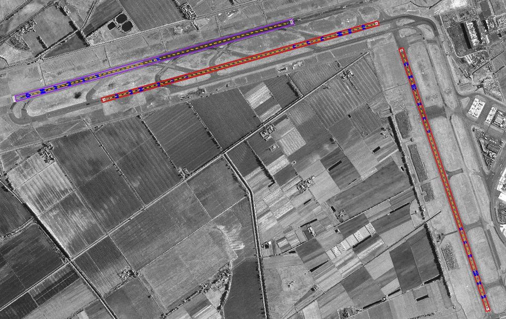
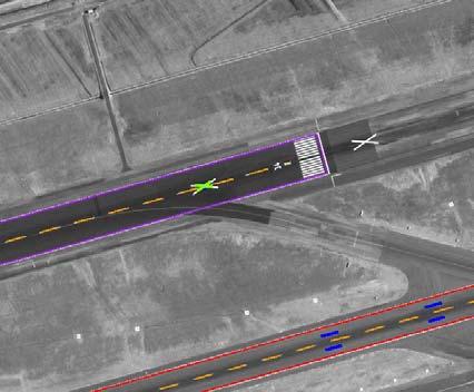
22 Example: KATL
23 GML2 Document Structure


24 Example Feature Runway Element 10.28

25 Example Feature: VerticalPolygonalStructure


26 Application Integration: Google Earth Note: 3-dimentional features Full attribute display Free

27 Application Integration: ESRI ArcGIS Explorer

28 AIXM Evolution Development History: DO-272 (2004) DO-272A (2006) DO-291 (2007) AIXM 5 (2008) Advantages Easy integration Into system With future FAA aero-spatial data Subset of industry GML standards Simple transformation from SHP > GML > AIXM Credit:
29 Integration Visualize and Analyze ESRI Platform ArcMap ArcGIS Explorer (free) Google Platform Google Earth (free) Additional Platforms ERDAS Process Image Processing 3D extraction Stereo visualization Image Analysis Raster change detection Routing Algorithms Custom client applications Vector Analysis Vector change detection
30 Vector-to-Vector Change Detection:
31 Questions: IATA John Synnott, Program Manager local 3400 GEOEYE Dejan Damjanovic, Program Manager (office) (mob)
32 Technology Definitions GeoEye Products Optical-imagery currently at 1-meter resolution Same-orbit Stereo Collection 3-dimentional Feature Extraction ESRI Shapefiles A vector data format for storing location, shape, and attribute information GML OpenGIS Geography Markup Language (GML) is an OGC encoding standard for geospatial information Safe Software Spatial Extract/Translate/Load (ETL) Toolset in the Feature Manipulation Engine (FME) Shapefile features to GML2 GML2 currently in use by GeoEye Previous versions ETL did not include Z axis for coordinates AIXM The Aeronautical Information Exchange Model (AIXM) is designed to enable the management and distribution of Aeronautical Information Services (AIS) data in digital format. AIXM describes the extensible markup language (XML) used in description, storage, transfer, and use of aeronautical information. AIXM is quickly becoming the global standard for aeronautical data, used by ICAO, FAA, NGA, Eurocontrol, and others as their standard language.
Federal GIS Conference February 10 11, 2014 Washington DC. ArcGIS for Aviation. David Wickliffe
 Federal GIS Conference 2014 February 10 11, 2014 Washington DC ArcGIS for Aviation David Wickliffe What is ArcGIS for Aviation? Part of a complete system for managing data, products, workflows, and quality
VALUE PROPOSITION FOR TRAINING AND SIMULATION A White Paper on Electronic Terrain & Obstacle collection
 VALUE PROPOSITION FOR TRAINING AND SIMULATION A White Paper on Electronic Terrain & Obstacle collection The FANS Group 8703 Yates Drive, suite 125 Westminster, Colorado 80031 www.fans-group.aero 877.710.7932
VALUE PROPOSITION FOR AIRPORT AUTHORITIES A White Paper on Electronic Terrain & Obstacle collection
 VALUE PROPOSITION FOR AIRPORT AUTHORITIES A White Paper on Electronic Terrain & Obstacle collection The FANS Group 8703 Yates Drive, suite 125 Westminster, Colorado 80031 www.fans-group.aero 877.710.7932
AMXM Airport Mapping picking-up SWIM
 Global Information Management AMXM Airport Mapping picking-up SWIM Presented By: Sam Van der Stricht Date: August 25, 2015 AMDB Applications EUROCAE / RTCA Applications: Moving Map Routing Runway Safety
ATIEC Presented by: D. Cowell (FAA) & E. Porosnicu (EUROCONTROL)
 & E. Porosnicu (EUROCONTROL)") ATIEC 2017 Presented by: D. Cowell (FAA) & E. Porosnicu (EUROCONTROL) Content AIXM usage - current and future Interoperability Digital NOTAM AIXM intended use AIXM 2.1/3.3/4.5 - developed for the EAD (European
ATIEC 2017 Presented by: D. Cowell (FAA) & E. Porosnicu (EUROCONTROL) Content AIXM usage - current and future Interoperability Digital NOTAM AIXM intended use AIXM 2.1/3.3/4.5 - developed for the EAD (European
AERONAUTICAL INFORMATION DIGITAL DATBASES INTERGATION AND QUALITY MANAGED MIGRATION
 AIM SG/5 (Egypt, Cairo, 22 24 January 2019) AERONAUTICAL INFORMATION DIGITAL DATBASES INTERGATION AND QUALITY MANAGED MIGRATION Presentation contents : 1. NG Aviation company overview 2. New documentation
Regional implementation of Electronic Terrain and Obstacle data (e-tod) (Presented by Jeppesen)
 (Presented by Jeppesen)") International Civil Aviation Organization SAM/IG/13-WP/39 South American Regional Office 5/04/14 Thirteenth Workshop/Meeting of the SAM Implementation Group English only (SAM/IG/13) - Regional Project
International Civil Aviation Organization SAM/IG/13-WP/39 South American Regional Office 5/04/14 Thirteenth Workshop/Meeting of the SAM Implementation Group English only (SAM/IG/13) - Regional Project
Avitech GmbH AIXM Capabilities & Experiences
 Avitech GmbH AIXM Capabilities & Experiences Werner Schwarze Regional Sales Director Dakar/04. October 2016 Avitech Introduction Avitech GmbH of Germany, is a key piece in Indra ATM being the unique provider
The D-AIM Project and Trials. Roger Li, D-AIM Project Manager LFV AIXM/WXXM Conference Washington DC, May 13, 2009
 The D-AIM Project and Trials Roger Li, D-AIM Project Manager LFV AIXM/WXXM Conference Washington DC, May 13, 2009 D-AIM Background Cooperation between LFV (Swedish Airports and Air Navigation Services)
Global Information Management. Status Report: AIXM
 Global Information Management Status Report: AIXM Presented By: Allen Proper, FAA Date: August 25, 2015 Content AIXM versions in use AIXM Change Control Board activity FAA perspective AIXM 4.5 Published:
INTERNATIONAL CIVIL AVIATION ORGANIZATION AFI REGION AIM IMPLEMENTATION TASK FORCE. (Dakar, Senegal, 20 22nd July 2011)
") IP-5 INTERNATIONAL CIVIL AVIATION ORGANIZATION AFI REGION AIM IMPLEMENTATION TASK FORCE (Dakar, Senegal, 20 22nd July 2011) Agenda item: Presented by: Implementation of a African Regional Centralised Aeronautical
IP-5 INTERNATIONAL CIVIL AVIATION ORGANIZATION AFI REGION AIM IMPLEMENTATION TASK FORCE (Dakar, Senegal, 20 22nd July 2011) Agenda item: Presented by: Implementation of a African Regional Centralised Aeronautical
RNP AR APCH Approvals: An Operator s Perspective
 RNP AR APCH Approvals: An Operator s Perspective Presented to: ICAO Introduction to Performance Based Navigation Seminar The statements contained herein are based on good faith assumptions and provided
TANZANIA CIVIL AVIATION AUTHORITY AIR NAVIGATION SERVICES INSPECTORATE. Title: CONSTRUCTION OF VISUAL AND INSTRUMENT FLIGHT PROCEDURES
 Page 1 of 8 1. PURPOSE 1.1. This Advisory Circular provides guidance to personnel involved in construction of instrument and visual flight procedures for publication in the Aeronautical Information Publication.
TERMS OF REFERENCE (Revision 9) Special Committee (SC) 213 Enhanced Flight Vision Systems/Synthetic Vision Systems
 Special Committee (SC) 213 Enhanced Flight Vision Systems/Synthetic Vision Systems") REQUESTOR: RTCA Paper No. 349-16/PMC-1568 TERMS OF REFERENCE (Revision 9) Special Committee (SC) 213 Enhanced Flight Vision Systems/Synthetic Vision Systems Organization Federal Aviation Administration,
REQUESTOR: RTCA Paper No. 349-16/PMC-1568 TERMS OF REFERENCE (Revision 9) Special Committee (SC) 213 Enhanced Flight Vision Systems/Synthetic Vision Systems Organization Federal Aviation Administration,
Navigation Data Chain Certification
 853d Electronic Systems Group Navigation Data Chain Certification Prepared by: 853rd ELSG/NT Electronic Systems Center Hanscom AFB, MA 23 May 2008 Nav Data Chain Certification Overview Background Why certify
Overview ICAO Standards and Recommended Practices for Aerodrome Mapping Data reported to AIM
 Overview ICAO Standards and Recommended Practices for Aerodrome Mapping Data reported to AIM References ICAO SARPS Annex 14 Vol. I, 7 th Edition, July 2016 ICAO SARPS Annex 15, 15 th Edition, July 2016
Aviation System Block Upgrades Module N B0-86/PIA-3
 International Civil Aviation Organization ASBU/SIP/Mexico/2012-WP/20 E Aviation System Block Upgrades Module N B0-86/PIA-3 Improved Access to Optimum Flight Levels through Climb/Descent Procedures using
EUROPEAN COMMISSION DIRECTORATE-GENERAL FOR MOBILITY AND TRANSPORT
 EUROPEAN COMMISSION DIRECTORATE-GENERAL FOR MOBILITY AND TRANSPORT DIRECTORATE E - Air Transport E.2 - Single sky & modernisation of air traffic control Brussels, 6 April 2011 MOVE E2/EMM D(2011) 1. TITLE
From AIS To AIM. Agenda. Agenda. Jack Hsu Mark Varellas
 Agenda Agenda From AIS To AIM 1. Introduction to MDA 2. What is AIS to AIM? 3. FAA Approach to AIM 4. AIM Transition Planning 5. ext Steps 1. Introduction to MDA 2. What is AIS to AIM? 3. FAA Approach
Space Based ADS-B. ICAO SAT meeting - June 2016 AIREON LLC PROPRIETARY INFORMATION
 Space Based ADS-B ICAO SAT meeting - June 2016 1 Options to Detect an Aircraft Position Position Accuracy / Update Interval Voice Position Reporting ADS-C Position Reporting Radar Surveillance / MLAT Space
User Forum AIM/EAD Evolutions. Thanos PAPAVRAMIDIS, Head of Airspace and AIS Data Management EUROCONTROL Network Management
 User Forum 2011 AIM/EAD Evolutions Thanos PAPAVRAMIDIS, Head of Airspace and AIS Data Management EUROCONTROL Network Management The European Organisation for the Safety of Air Navigation EAD General Concept
Aeronautical METeorology in Europe
 Aeronautical METeorology in Europe Weather Information Modelling Activities Dennis Hart Aeronautical Information Management Division EUROCONTROL European Organisation for the Safety of Air Navigation Overview
AIXM/WXXM CONFERENCE 2010
 AIXM/WXXM CONFERENCE 2010 ICAO Aeronautical Information Services Aeronautical Information Management Study Group (AIS-AIMSG) Development of Standards and Recommended Practices (SARPS) Presented to: AIXM/WXXM
USE OF 3D GIS IN ANALYSIS OF AIRSPACE OBSTRUCTIONS
 USE OF 3D GIS IN ANALYSIS OF AIRSPACE OBSTRUCTIONS A project by by Samuka D. W. F19/1461/2010 Supervisor; Dr D. N. Siriba 1 Background and Problem Statement The Airports in Kenya are the main link between
AIXM Coding guidelines for the ICAO data sets
 AIXM Coding guidelines for the ICAO data sets Eduard POROSNICU DECMA/STR/SWM July 2018 Context Restructured Annex 15 Digital data sets AIP Obstacles Terrain Airport Mapping Instrument Flight Procedures
ICAO CAR/SAM electronic Terrain and Obstacle Data (etod) Seminar Mexico City Tuesday Nov 24 th, 2015
 Seminar Mexico City Tuesday Nov 24 th, 2015") 1 ICAO CAR/SAM electronic Terrain and Obstacle Data (etod) Seminar Mexico City Tuesday Nov 24 th, 2015 Dejan Damjanovic, Managing Director, FANS Group 2 Agenda Topics 1. Global Air Navigation Plan from
1 ICAO CAR/SAM electronic Terrain and Obstacle Data (etod) Seminar Mexico City Tuesday Nov 24 th, 2015 Dejan Damjanovic, Managing Director, FANS Group 2 Agenda Topics 1. Global Air Navigation Plan from
DP-7 The need for QMS controlled processes in AIS/AIM. Presentation to QMS for AIS/MAP Service Implementation Workshop Dakar, Senegal, May 2011
 DP-7 The need for QMS controlled processes in AIS/AIM Presentation to QMS for AIS/MAP Service Implementation Workshop Dakar, Senegal, 17 19 May 2011 Werner Kurz Director International Relations Jeppesen
AIS-AIM Study Group Working Status
 International Civil Aviation Organization AIS-AIM Study Group Working Status Roberta Luccioli TO/AIM Seminario de la OACI sobre la Transicion al AIM Fases1 3 Outline Development and Implementation of AIS
Sharing UAE experience in. AIM implementation
 Sharing UAE experience in AIM implementation NCLB AIM WORKSHOP Cairo, Egypt, 11 13 September 2017 MID Region NCLB Strategy No Country Left Behind campaign help ensure all States of effective implementation
etod: State of Affairs Global AIM Kampala - Session 5 24 th May 2017 Jan-Philipp LAUER, MSc
 etod: State of Affairs Global AIM Kampala - Session 5 24 th May 2017 Jan-Philipp LAUER, MSc jan-philipp.lauer@dfs.de Overview Content The need for etod Regulatory situation Technical situation Conclusions
Operators may need to retrofit their airplanes to ensure existing fleets are properly equipped for RNP operations. aero quarterly qtr_04 11
 Operators may need to retrofit their airplanes to ensure existing fleets are properly equipped for RNP operations. 24 equipping a Fleet for required Navigation Performance required navigation performance
Lufthansa Systems AIM from a navigation data house perspective
 AIM/SAM/10, August 2017 Lima Peru Lufthansa Systems AIM from a navigation data house perspective genda The Company & Products Electronic Terrain and Obstacle Data (etod) Transition from AIS to AIM Aeronautical
RISING PERFORMANCE. Civil aviation is an outlier. It s BY ERIK DAHLBERG
 RISING PERFORMANCE Compact mobile mapping systems can be installed on small passenger cars. Civil aviation is an outlier. It s among the few industries where tight government regulations are widely accepted
COMMISSION REGULATION (EU)
") L 23/6 Official Journal of the European Union 27.1.2010 COMMISSION REGULATION (EU) No 73/2010 of 26 January 2010 laying down requirements on the quality of aeronautical data and aeronautical information
L 23/6 Official Journal of the European Union 27.1.2010 COMMISSION REGULATION (EU) No 73/2010 of 26 January 2010 laying down requirements on the quality of aeronautical data and aeronautical information
This document is meant purely as a documentation tool and the institutions do not assume any liability for its contents
 2010R0073 EN 20.10.2014 001.001 1 This document is meant purely as a documentation tool and the institutions do not assume any liability for its contents B COMMISSION REGULATION (EU) No 73/2010 of 26 January
agis a brief overview
 agis a brief overview Steve Welebny Photogrammetrist Keystone Aerial Surveys Villanova University 1 Villanova University 2 Nav Aid Cost VOR Install = $250,000 20 year life cycle cost = $1,100,000 ILS Install
EUROCONTROL. Centralised Services concept. Joe Sultana Director Network Manager 1 July 2013
 EUROCONTROL Centralised Services concept Joe Sultana Director Network Manager 1 July 2013 EUROCONTROL Centralised Services 2 Why do we need Centralised Services? Europe needs to be competitive again! a
Real-time route planning streamlines onboard operations, reduces fuel burn and delays, and improves on-time performance.
 Real-time route planning streamlines onboard operations, reduces fuel burn and delays, and improves on-time performance. Operational Efficiency of Dynamic Navigation Charting Benefits such as improved
Electronic Terrain and Obstacle Data
 International Civil Aviation Organization Electronic Terrain and Obstacle Data David Lewtas Chief, Aeronautical Information Unit (MET/AIM) 24 November 2010 ICAO CAR AIM Seminar Kingston, Jamaica 22-24
Aeronautical Information Management
 Aeronautical Information Management NOTAM Activities Introduction Presented to: By: Barry C. Davis Date: May 3, 2011 What s AIM? Dynamic, integrated management of aeronautical information services safely,
AUGUST 2017 GNSS REVIEW. Survey Economics Chances of success. Mobile Mapping Airport scanning. Stag s Leap Winery Pre-construction plan
 AUGUST 2017 GNSS REVIEW Survey Economics Chances of success Stag s Leap Winery Pre-construction plan Mobile Mapping Airport scanning RISING PERFORMANCE» ERIK DAHLBERG Civil aviation is an outlier. It s
Air Traffic Management
 Air Traffic Management Transforming Air Traffic Management T rans f orming A ir Today s airspace users are grappling with the air traffic control system s inability to manage an ever-growing amount of
OVERVIEW OF THE FAA ADS-B LINK DECISION
 June 7, 2002 OVERVIEW OF THE FAA ADS-B LINK DECISION Summary This paper presents an overview of the FAA decision on the ADS-B link architecture for use in the National Airspace System and discusses the
ICAO GANP Requirements and Evolution
 ICAO GANP Requirements and Evolution Olga de Frutos Brussels/October 2017 Flight Plan Context Current GANP Role in ICAO Next edition: AMET, DATM, FICE and SWIM The future ATM system To achieve an interoperable
Safety Enhancement SE ASA Design Virtual Day-VMC Displays
 Safety Enhancement SE 200.2 ASA Design Virtual Day-VMC Displays Safety Enhancement Action: Implementers: (Select all that apply) Statement of Work: Manufacturers develop and implement virtual day-visual
10+ years of EAD: picking the low-hanging fruit. guido HAESEVOETS EAD Customer Management 29/01/2015
 10+ years of EAD: picking the low-hanging fruit guido HAESEVOETS EAD Customer Management 29/01/2015 10+ years of EAD Principles EUROCONTROL operates and manages the EAD on behalf of its Member States,
WORLDWIDE SYMPOSIUM ON ENABLING THE NET-CENTRIC INFORMATION ENVIRONMENT:
 WORLDWIDE SYMPOSIUM ON ENABLING THE NET-CENTRIC INFORMATION ENVIRONMENT: SUPPORTING A GLOBALLY HARMONIZED AND SEAMLESS ATM SYSTEM Vince Galotti Chief/ATM ICAO 2 June 2008 Presentation Outline What is a
Implementation challenges for Flight Procedures
 Implementation challenges for Flight Procedures A Data-house perspective for comprehensive Procedure Design solution: A need today Sorin Onitiu Manager Business Affairs, Government & Military Aviation,
Terms of Reference for a rulemaking task
 Rulemaking Directorate Terms of Reference for a rulemaking task Technical requirements and operational procedures for the provision of data for airspace users for the purpose of air navigation ISSUE 1
Aeronautical Information Exchange Model (AIXM) Lessons learned
 Lessons learned") Aeronautical Information Exchange Model (AIXM) Lessons learned railml.org conference, Paris Speaker: Eduard Porosnicu EUROCONTROL, Senior AIM Specialist 18 Sep 2013 Contents About Eurocontrol AIXM purpose
Aeronautical Information Exchange Model (AIXM) Lessons learned railml.org conference, Paris Speaker: Eduard Porosnicu EUROCONTROL, Senior AIM Specialist 18 Sep 2013 Contents About Eurocontrol AIXM purpose
On Time. Total Airspace Management. 8 th Global ATFM Conference Cancun - Mexico. 12/30/2014 Commercial-in-Confidence 1
 On Time Total Airspace Management 8 th Global ATFM Conference Cancun - Mexico 12/30/2014 Commercial-in-Confidence 1 ATFM 101 Services Airspace capacity optimization Flight Procedure PBN design SID s STARS
TERMS OF REFERENCE Special Committee (SC) 209 Minimum Operational Performance Standards for ATCRBS/Mode S Transponder (Rev 6)
 209 Minimum Operational Performance Standards for ATCRBS/Mode S Transponder (Rev 6)") TERMS OF REFERENCE Special Committee (SC) 209 Minimum Operational Performance Standards for ATCRBS/Mode S Transponder (Rev 6) 1. REQUESTORS: Organization Federal Aviation Administration Person David Hempe
TERMS OF REFERENCE Special Committee (SC) 209 Minimum Operational Performance Standards for ATCRBS/Mode S Transponder (Rev 6) 1. REQUESTORS: Organization Federal Aviation Administration Person David Hempe
IWXXM and WXXM Update. By: Aaron Braeckel Date: 22 September 2016
 IWXXM and WXXM Update Presented to: ATIEC 2016 By: Aaron Braeckel Date: 22 September 2016 Weather Data Model Evolution IWXXM & WXXM are key to concepts and applications in ICAO, WMO, and NextGen/SESAR
Quality Assurance. Introduction Need for quality assurance Answer to the need of quality assurance Details on quality assurance Conclusion A B C D E
 Quality Assurance 1 A B C D E Introduction Need for quality assurance Answer to the need of quality assurance Details on quality assurance Conclusion 2 1 Introduction 3 Introduction The implementation
Modernising UK Airspace 2025 Vision for Airspace Tools and Procedures. Controller Pilot Symposium 24 October 2018
 Modernising UK Airspace 2025 Vision for Airspace Tools and Procedures Controller Pilot Symposium 24 October 2018 Our airspace Flight Information Regions London & Scottish FIRs: 1m km 2 11% of Europe s
TERMS OF REFERENCE Special Committee (SC) 216 Aeronautical Systems Security (Revision 8)
 216 Aeronautical Systems Security (Revision 8)") RTCA Paper No. 090-18/PMC-1733 March 22, 2018 TERMS OF REFERENCE Special Committee (SC) 216 Aeronautical Systems Security (Revision 8) REQUESTORS: Boeing Commercial Airplanes Organization Person Munir
RTCA Paper No. 090-18/PMC-1733 March 22, 2018 TERMS OF REFERENCE Special Committee (SC) 216 Aeronautical Systems Security (Revision 8) REQUESTORS: Boeing Commercial Airplanes Organization Person Munir
OBSTACLE IDENTIFICATION SURFACE CALCULATION TOOL (OIS CT) FOR AIRPORT AIRSPACE OBSTRUCTION ANALYSES AT CIVIL AIRPORTS IN THE UNITED STATES
 FOR AIRPORT AIRSPACE OBSTRUCTION ANALYSES AT CIVIL AIRPORTS IN THE UNITED STATES") OBSTACLEIDENTIFICATIONSURFACECALCULATIONTOOL(OISCT) FORAIRPORTAIRSPACEOBSTRUCTIONANALYSESATCIVILAIRPORTS INTHEUNITEDSTATES ApostolPanayotov,PhD,Mr.MarkGibbs,M.S.A,A.A.E,Mr.BradKetel IntroductiontotheObstacleIdentificationSurfaceAnalyses
OBSTACLEIDENTIFICATIONSURFACECALCULATIONTOOL(OISCT) FORAIRPORTAIRSPACEOBSTRUCTIONANALYSESATCIVILAIRPORTS INTHEUNITEDSTATES ApostolPanayotov,PhD,Mr.MarkGibbs,M.S.A,A.A.E,Mr.BradKetel IntroductiontotheObstacleIdentificationSurfaceAnalyses
THE DEVELOPMENT OF NATIONAL PERFORMANCE FRAMEWORK FOR AIR NAVIGATION SYSTEMS MAURITIUS
 THE DEVELOPMENT OF NATIONAL PERFORMANCE FRAMEWORK FOR AIR NAVIGATION SYSTEMS MAURITIUS 2011-2015 Presented by Ahmed Mosaheb Chief Officer ATM MAURITIUS Characteristics of the Industry FIR- 9,000,000 sq
2012 Performance Framework AFI
 2012 Performance Framework AFI Nairobi, 14-16 February 2011 Seboseso Machobane Regional Officer ATM, ESAF 1 Discussion Intro Objectives, Metrics & Outcomes ICAO Process Framework Summary 2 Global ATM Physical
Optimizing trajectories over the 4DWeatherCube
 Optimizing trajectories over the 4DWeatherCube Detailed Proposal - SES Awards 2016 Airbus Defence and Space : dirk.schindler@airbus.com Luciad : robin.houtmeyers@luciad.com Eumetnet : kamel.rebai@meteo.fr
Overview of Evolution to Performance Based Navigation. ICAO PBN Seminar Overview of Evolution to Performance Based Navigation
 Overview of Evolution to Performance Based Navigation 1 Overview Learning Objectives: at the end of this presentation you should: Understand what are the two main elements of Performance Based Navigation
Session III Issues for the Future of ATM
 NEXTOR Annual Research Symposium November 14, 1997 Session III Issues for the Future of ATM Synthesis of a Future ATM Operational Concept Aslaug Haraldsdottir, Boeing ATM Concept Baseline Definition Aslaug
Data Origination, Management and WGS 84. ICAO PBN Seminar Data Origination & Management and WGS 84
 Data Origination, Management and WGS 84 1 Learning Objectives Overview Understand the implication of publishing incorrect navigational data in the State s AIP Identify why it is essential to use a common
Aeronautical Data Quality - A New Challenge for Surveyors
 Aeronautical Data Quality - A New Challenge for Surveyors Ralf Wolfgang SCHROTH, Germany Key words: surveying, work flow management, aeronautical data quality, International Civil Aviation Organisation
AIS Basics - NOTAM, AIP, Amendments, Supplements, Circulars, Charts, and NOTAM Putting the basics in place
 AIS Basics - NOTAM, AIP, Amendments, Supplements, Circulars, Charts, and NOTAM Putting the basics in place Workshop for the development of AIS management and oversight for Civil Aviation Authorities CAA)
Work Programme of ICAO Panels and Study Groups
 SIP/2009-WP/16 Performance framework Work Programme of ICAO Panels and Study Groups H.V. SUDARSHAN, Regional Programme Officer International Civil Aviation Organization Workshop on the Development of National
PBN Implementation. Phil Rakena. PBN Implementation Programme Manager
 Implementation Phil Rakena Implementation Programme Manager CANSO APAC Conference - 06 th May 2017 Implementation Scope: What, Why, When? How to? o Needs / Plan o Collaborate o Educate o Regulate o Resource
OPERATIONS CIRCULAR 01/2012. Subject: HEAD-UP DISPLAYS (HUD) AND ENHANCED VISION SYSTEMS (EVS)
 AND ENHANCED VISION SYSTEMS (EVS)") GOVERNMENT OF INDIA CIVIL AVIATION DEPARTMENT OFFICE OF THE DIRECTOR GENERAL OF CIVIL AVIATION OPP. SAFDARJUNG AIRPORT, NEW DELHI 110 003 TELEPHONE: 091-011-4635261 4644768 FAX: 091-011-4644764 TELEX:
GOVERNMENT OF INDIA CIVIL AVIATION DEPARTMENT OFFICE OF THE DIRECTOR GENERAL OF CIVIL AVIATION OPP. SAFDARJUNG AIRPORT, NEW DELHI 110 003 TELEPHONE: 091-011-4635261 4644768 FAX: 091-011-4644764 TELEX:
Guidance for Complexity and Density Considerations - in the New Zealand Flight Information Region (NZZC FIR)
") Guidance for Complexity and Density Considerations - in the New Zealand Flight Information Region (NZZC FIR) Version 1.0 Director NSS 14 February 2018 Guidance for Complexity and Density Considerations
Guidance for Complexity and Density Considerations - in the New Zealand Flight Information Region (NZZC FIR) Version 1.0 Director NSS 14 February 2018 Guidance for Complexity and Density Considerations
From AIS to AIM. COMSOFT AIS to AIM Lima, Peru Context and Overview Isabel Zambrano Rodriguez
 From AIS to AIM COMSOFT AIS to AIM Lima, Peru 24-28.11.2014 Context and Overview Isabel Zambrano Rodriguez Context: Challenges to AIS Worldwide AIS throughout the world face a number of challenges : Air
FLIGHT OPERATIONS PANEL
 International Civil Aviation Organization FLTOPSP/WG/2-WP/11 24/04/2015 WORKING PAPER FLIGHT OPERATIONS PANEL WORKING GROUP SECOND MEETING (FLTOPSP/WG2) Rome, Italy 4 to 8 May 2015 Agenda Item 6: Any Other
QMS for AIS/MAP Service Implementation Workshop
 TITLE DP-9 QMS for AIS/MAP Service Implementation Workshop AIS to AIM transitions: The AFI challenges The global evolution from AIS to AIM capability is considered an essential and over-arching objective
TWELFTH AIR NAVIGATION CONFERENCE
 International Civil Aviation Organization AN-Conf/12-WP/6 7/5/12 WORKING PAPER TWELFTH AIR NAVIGATION CONFERENCE Agenda Item 2: Aerodrome operations improving airport performance 2.2: Performance-based
SESAR Active ECAC INF07 REG ASP MIL APO USE INT IND NM
 SESAR Active ECAC INF07 REG ASP MIL APO USE INT IND NM Subject matter and scope * The extension of the applicability area to non-eu ECAC States that have not signed an aviation agreement with EU, as well
REGULATION No. 10/2011 ON APPROVAL OF FLIGHT PROCEDURES INCLUDING SID-s AND STAR-s. Article 1 Scope of Application
 Republika e Kosovës Republika Kosovo Republic of Kosovo Autoriteti i Aviacionit Civil i Kosovës Autoritet Civilnog Vazduhoplovstva Kosova Civil Aviation Authority of Kosovo Director General of Civil Aviation
PBN Performance. Based Navigation. - PBN & Airspace Concepts - ICAO PBN Seminar Introduction to PBN
 PBN Performance Based Navigation - PBN & Airspace Concepts - Introduction to PBN 1 Learning Objectives PBN Concept within the context of an Airspace (Operational) Concept. Introduction to PBN 2/37 Components
European Aeronautical Common Position WRC 2012
 Ref. Ares(2015)1631050-16/04/2015 COVERNOTE UAS SPECTRUM POSITION PAPER FOR European Aeronautical Spectrum Frequency Consultation Group (ASFCG) European Aeronautical Common Position WRC 2012 This is an
ADQ Regulators Working Group
 ADQ Regulators Working Group Common Understanding 01/2013 Application of the provisions of Commission Regulation (EU) 73/2010 to NOTAM Edition: 1.4 Date: 20 October 2016 Reference: ARWG CU 01/2013 ARWG
FLIGHT PATH FOR THE FUTURE OF MOBILITY
 FLIGHT PATH FOR THE FUTURE OF MOBILITY Building the flight path for the future of mobility takes more than imagination. Success relies on the proven ability to transform vision into reality for the betterment
Aerodrome Safety. H.V. SUDARSHAN International Civil Aviation Organization
 NPF/SIP/2010-WP/19 Aerodrome Safety H.V. SUDARSHAN International Civil Aviation Organization Workshop on the development of National Performance Framework for Air Navigation Systems (Nairobi, 6-10 December
ATM STRATEGIC PLAN VOLUME I. Optimising Safety, Capacity, Efficiency and Environment AIRPORTS AUTHORITY OF INDIA DIRECTORATE OF AIR TRAFFIC MANAGEMENT
 AIRPORTS AUTHORITY OF INDIA ATM STRATEGIC PLAN VOLUME I Optimising Safety, Capacity, Efficiency and Environment DIRECTORATE OF AIR TRAFFIC MANAGEMENT Version 1 Dated April 08 Volume I Optimising Safety,
Learning Objectives. By the end of this presentation you should understand:
 Designing Routes 1 Learning Objectives By the end of this presentation you should understand: Benefits of RNAV Considerations when designing airspace routes The basic principles behind route spacing The
Got Mountains? Challenges of Modeling SRTM and Other Terrain Data to Suit Aviation Applications
 Got Mountains? Challenges of Modeling SRTM and Other Terrain Data to Suit Aviation Applications M. Fox, B. Dorrell, L. Haskell, Jeppesen, 55 Inverness Drive East, Englewood, CO 80112 Abstract Jeppesen,
Singapore s Journey to Implement ASBU B-0 & B-1 Modules in PIA-2
 Singapore s Journey to Implement ASBU B-0 & B-1 Modules in Scope Introduction Strategy for Implementation of ASBU AIDC Implementation Plan (B0-FICE) AIM-SG (B0-DATM) Aeronautical Meteorology (B0-AMET)
Leverage and demonstrate one of AIXM s main benefits: Make AIS Dynamic Data Understandable and Usable for Computer-driven Applications!
 xnotam/amdb study Study on the applicability of the xnotam concept for updating Airport Mapping Database (AMDB) applications Darmstadt University under contract of EUROCONTROL Christian Grothe grothe@fsr.tu-darmstadt.de
MIDAD Project IDS Vision
 MIDAD Project IDS Vision Cairo July, 2013 Ramy El-Jabi Outline MIDAD Scope Solution High Level Architecture IDS Air Navigation Suite Proposed Implementation Schedule 2 MIDAD Scope Drawbacks related to
Global Runway Safety Simposium
 Global Runway Safety Simposium A DIFFERENT PERSPECTIVE OF SAFETY AND ITS RELATIONSHIP WITH SURROUNDINGS Costantino Pandolfi LIMA, 11/21/2017 Italian Civil Aviation Authority ICAO ADOP Member Panel 8 New
Atennea Air. The most comprehensive ERP software for operating & financial management of your airline
 Atennea Air The most comprehensive ERP software for operating & financial management of your airline Atennea Air is an advanced and comprehensive software solution for airlines management, based on Microsoft
Airport Safety Management Systems: Integrating Planning Into the Process
 Airport Safety Management Systems: Integrating Planning Into the Process Kenneth Jacobs Senior Airport Planner FAA Airport Planning and Environmental Division ken.jacobs@faa.gov SMS Defined A process for
PRO LINE FUSION INTEGRATED AVIONICS SYSTEM. Pro Line Fusion on Gulfstream G280: Your direct path to see and access more.
 Pro Line Fusion on Gulfstream G280: Your direct path to see and access more. Starting with its baseline features, the Pro Line Fusion avionics in your Gulfstream PlaneView280 flight deck offer capabilities
TERMS OF REFERENCE Special Committee (SC) 186 Automatic Dependent Surveillance Broadcast (ADS-B) Revision 22
 186 Automatic Dependent Surveillance Broadcast (ADS-B) Revision 22") TERMS OF REFERENCE Special Committee (SC) 186 Automatic Dependent Surveillance Broadcast (ADS-B) REQUESTORS: Organization Federal Aviation Administration Person Steve Zaidman SC LEADERSHIP: Position Name
TERMS OF REFERENCE Special Committee (SC) 186 Automatic Dependent Surveillance Broadcast (ADS-B) REQUESTORS: Organization Federal Aviation Administration Person Steve Zaidman SC LEADERSHIP: Position Name
PBN Operational Approval Oceanic and Remote En Route Navigation Specifications
 PBN Operational Approval Oceanic and Remote En Route Navigation Specifications Navigation Specifications Applicable to Oceanic/Remote RNAV 10 (RNP 10) RNP 4 RNP 2 A-RNP 2 Prior Guidance Material RNP 10
ICAO Initiatives on Global Tracking
 ICAO Initiatives on Global Tracking Nancy Graham Director, Air Navigation Bureau, ICAO Expert Dialogue on Real-time Monitoring of Flight Data, including the Black Box the Need for International Standards
Sample Regulations for Water Aerodromes
 Sample Regulations for Water Aerodromes First Edition (unedited version) March 2015 Notice to users: This document is an unedited version which is made available to the public for convenience. Its content
Amendment 37,38 to Annex 15 Amendment 57 to Annex 4
 International Civil Aviation Organization Amendment 37,38 to Annex 15 Amendment 57 to Annex 4 Roberta Luccioli TO/AIM Seminario de la OACI sobre la Transicion al AIM Fases1 3 Outline 1. Amendment 37 to
Spatio-temporal Data Analysis and Visualization in Enterprise Level Automated Application
 Spatio-temporal Data Analysis and Visualization in Enterprise Level Automated Application Sept 29 - Oct 1, 2015 Kualal Lumpur Shyam Parhi Washington DC What is driving Airports GIS? Reduce costs to Airports,
Aeronautical Information Services Update on Aeronautical Information Exchange Model (AIXM)
") Aeronautical Information Services Update on Aeronautical Information Exchange Model (AIXM) Presented to: ATIEC 2016 By: D. Cowell (FAA), E. Porosnicu (EUROCONTROL) Date: 22 August 2016 Content AIXM versions
Aeronautical Information Services Update on Aeronautical Information Exchange Model (AIXM) Presented to: ATIEC 2016 By: D. Cowell (FAA), E. Porosnicu (EUROCONTROL) Date: 22 August 2016 Content AIXM versions
FLIGHT OPERATIONS PANEL (FLTOPSP)
") International Civil Aviation Organization FLTOPSP/1-WP/3 7/10/14 WORKING PAPER FLIGHT OPERATIONS PANEL (FLTOPSP) FIRST MEETING Montréal, 27 to 31 October 2014 Agenda Item 4: Active work programme items
International Civil Aviation Organization FLTOPSP/1-WP/3 7/10/14 WORKING PAPER FLIGHT OPERATIONS PANEL (FLTOPSP) FIRST MEETING Montréal, 27 to 31 October 2014 Agenda Item 4: Active work programme items
Advisory Circular. Automatic Dependent Surveillance - Broadcast
 Advisory Circular Subject: Automatic Dependent Surveillance - Broadcast Issuing Office: Standards PAA Sub Activity Area: Aviation Safety Regulatory Framework Document No.: AC 700-009 File Classification
The Importance of AIM and the Operational Concept
 Global Harmonization Through Collaboration The Importance of AIM and the Operational Concept Presented By: Michael Hohm International Civil Aviation Organization Date: August 28, 2012 Flightplan Background