THE SO-CALLED HOMINY-HOLES OF KENTUCKY
|
|
|
- Adelia Marsh
- 5 years ago
- Views:
Transcription
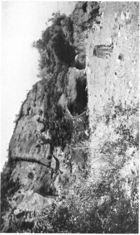
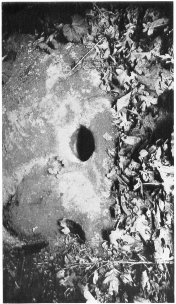
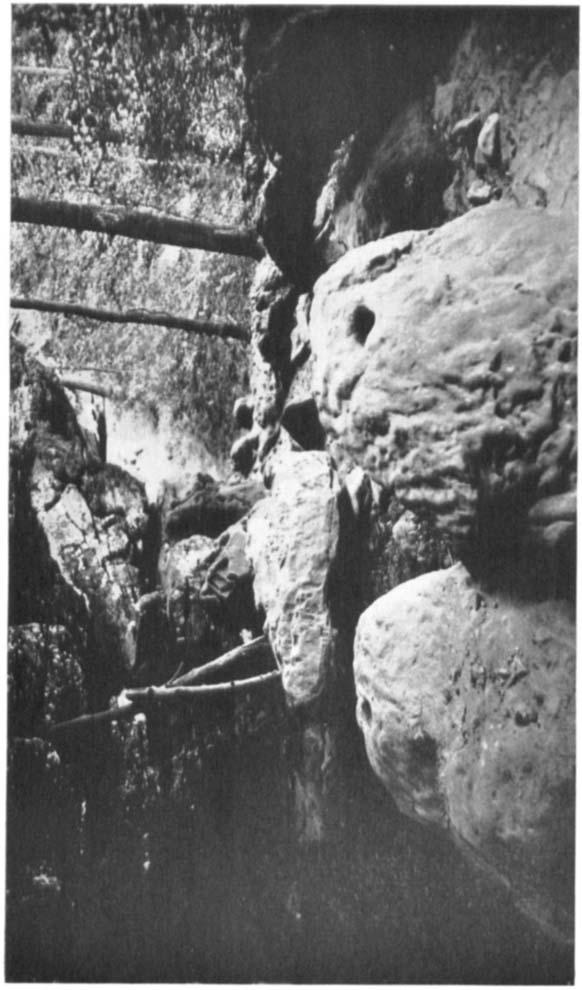
1 THE SO-CALLED HOMINY-HOLES OF KENTUCKY E BY W. S. WEBB AND W. D. FUNKHOUSER VIDENCES of what apparently represents a peculiar method used by aboriginal Americans in grinding corn or other materials are to be found in certain parts of Kentucky in the form of ancient mortars commonly known as hominyholes. They occur on the floor of rock shelters or in boulders at the entrance to such shelters in the ciiff regions of the state, and consist of conical holes excavated in the rock and generally worn smooth and deep by long use. In or near such holes may usually be found the pesties which were evidently used for crushing or grinding the grain in the holes. The holes are often two or three feet deep, generally six or seven inches in diameter at the top and gradually narrower toward the bottom. They are usually bored straight downward in the face of the cliff or in an exposed ledge or fallen boulder not far from the overhanging roof which provided the shelter. That they were an absolute necessity to the dwellers in these shelters and that they were constantly used is proved by the fact that it is very unusual to find a true rock shelter in the particular region described without one, and the additional fact that where a long series of shelters are found along the face of a single cliff, there are generally one or tuo and sometimes several holes in front of each shelter. In such cases one of the holes will be very deep, perhaps so deep that it could no longer easily be emptied, another will be shallower, and perhaps one or two others just started. The pestles are usually of limestone, from six inches to a foot or more in length, two or three inches in diameter, roughly cone-shaped, broad, flat and flanged at one end and rounded at the other, and sometimes marked with ridges or grooves. The lips of the holes are also occasionally grooved or roundly notched. There seems to be no question but that this represents a primitive type of grinding mill which, so far as we are aware, has not been commonly found in this country 701

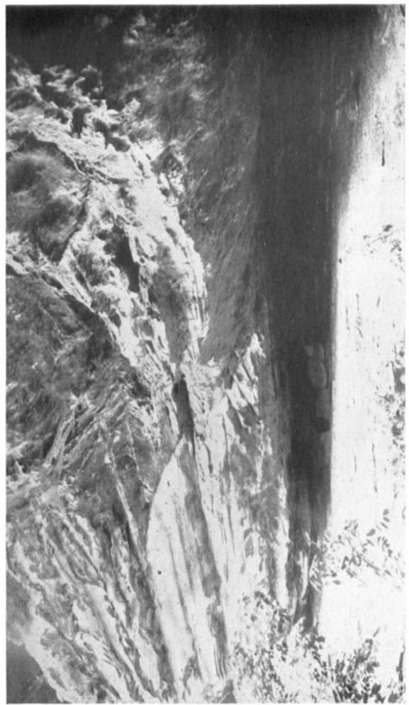
2 102 AMERICAN ANTHROPOLOGIST [N. S., 31,1929 nor carefully described in previous archaeological reports from this part of the Mississippi valley. GEOGRAPHICAL DISTRIBUTION So far as we have been able to learn, the sites of these hominyholes are limited to that part of Kentucky which is drained by the Green river and its tributaries. We have traced them through Hardin, Breckinridge, Grayson, and Hart counties along the streams emptying into Rough creek and Nolin river, both of which are tributaries of Green river, and have records of them in Ohio, Muhlenberg, and Logan counties, all of which are in the Green river drainage area. We have yet to secure a record of a hominy-hole from any other part of the state. It would be rather interesting if the distribution proved to be limited to this particular region, as now seems to be the case, and to represent the habit of a single group of people living along this one watercourse. We have previously reported hominy-holes (Ancient Life in Kentucky, , 1928) from a number of localities in this area and, in fact, were able to bring to the University of Kentucky a single huge sandstone boulder containing such a hole from Hart county, after bringing it down the side of the cliff, dragging it a mile or more over a creek bed, and carrying it twenty miles on a wagon over extremely bad roads to the nearest railroad, but only recently have we been impressed with the apparent definite and limited distribution. TOPOGRAPHY The Kentucky cliffs abound in overhanging walls of rock, beneath which shelter is easily obtainable. These shelters are locally known as rock-houses and were undoubtedly used as habitations in prehistoric times. Within the shelters are often found graves and beneath them, at the foot of the cliffs, large kitchen-middens, sometimes so extensive and so full of bones and other organic matter, that the farmers of the neighborhood haul the material away and spread it over the fields to enrich the land, a purpose to which it is well adapted. The region under discussion lies partly in the so-called Knobs and partly in the cavernous limestone area of the state. In the
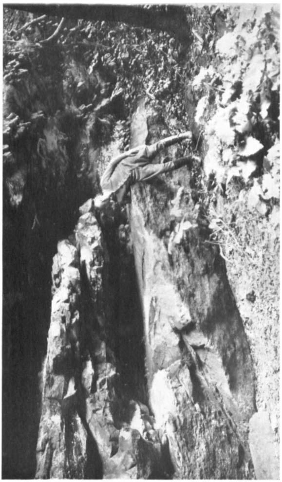
3 WEBB AND PUNKHOUSER] HOMIN Y-HOLES OF KENTUCKY 703 Knobs the geological outcrops are largely in the Chester series and the cliffs and overhanging ledges occur along the canyon walls of streams where the water has cut a gorge and has eroded the softer strata of the sandstone to form the pockets or caverns; in the latter, the streams are largely underground and form the lost rivers and subterranean waters for which the region is famous. Here the shelters are in the sides of old valleys or above large sinks. The country is very rough and the shelters, due to more recent erosions, are often almost inaccessible. The region is largely unproductive and is thinly settled. Travel is extremely difficult since the dirt roads are impassable in wet weather and the cliffs can be reached from the nearest highway only on horseback. It sometimes happens, too, that strangers are not welcomed, since the ravines beneath the cliffs may shelter other industries than those of prehistoric tribes who used the hominy-holes, and it is not always good policy to insist on extended explorations. However, the authors have usually been able, by assurance that they were deaf, dumb, and blind to everything but hominy-holes while in the gorges, and that they promptly lost their memory afterward (an assurance which, needless to say, has always been religiously observed) to locate the sites and make measurements and photographs. SPECIAL SITES The authors have recently made a short survey trip into parts of Hardin and Breckinridge counties and are able to report the following definite sites of hominy-holes which have not been previously recorded. Due to the fact that it rained almost continuously during the entire trip, the conditions for photography in the dark rock shelters were extremely poor but the photographs here reproduced will, it is believed, give a fair idea of the appearance of the hominy-holes and their environments. 1. Hardin county. Nine miles southwest of Vine Grove. On farm of Hugh Yates. A line of cliffs averaging about 90 feet in height extends for over a mile in a rough northeast by southwest curve across this area. They stand above a broad depression, 775 feet above sea level, in which are several ponds. The outcrop is Cypress sandstone. Two shelters are found in this cliff.

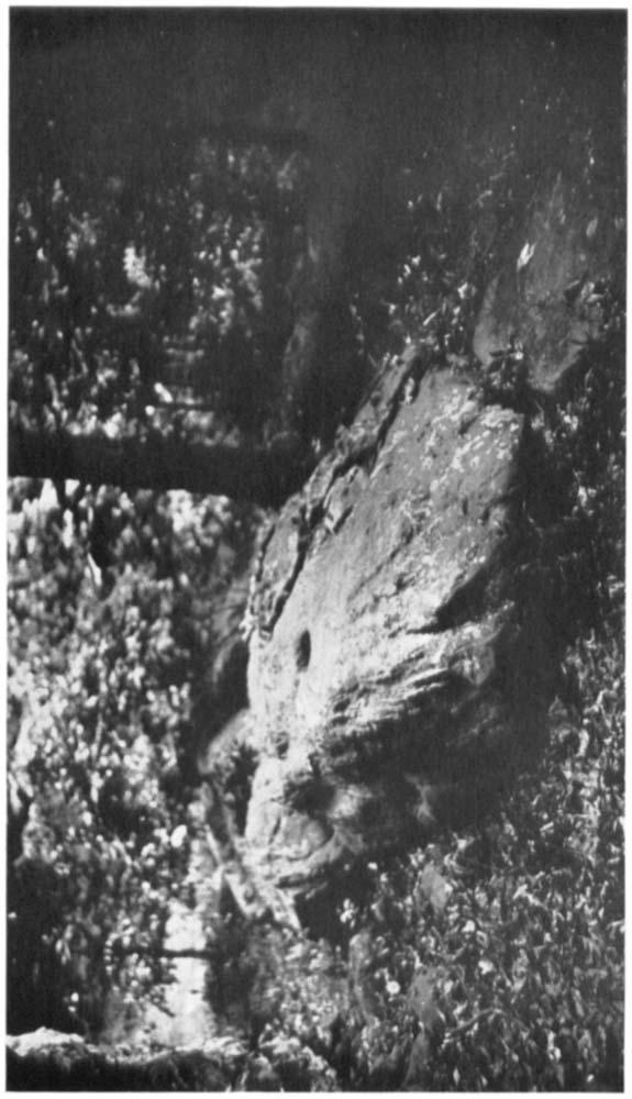
4 7 04 AMERICAN ANTHROPOLOGIST IN. S., 31,1929 The first is large and faces due east. The floor is of made dirt which has been excavated to a depth of nearly fifteen feet without reaching a rock bottom and the dirt has been spread over the surrounding fields for fertilizer. This made dirt contains a large amount of ashes and animal bones and in it were found fifteen or more human skeletons and many hundred artifacts. lhe authors secured a large number of the artifacts and one human skull. lhe owner of the property had agreed to save the other skeletons and had brought the bones to the house and piled them behind the wood-box in the kitchen. Immediately, however, his wife s rheumatism became so bad that he removed the bones from the house and plowed them under between the corn rows. (We were not able to learn whether or not the rheumatism at once improved.) The hominy-hole in this shelter is in a ledge which projects about 2 feet from the northeast wall. The hole measured 8x7 inches in diameter at the top and is 29 feet deep. The second shelter on this site is les; than a hundred yards from the first, around a bend of the cliff, and faces southeast. This is a smaller shelter and the rock floor is covered by only a few inches of dirt. The hominy-hole is on the floor, 5 feet from the back of the shelter. This hole is 7 inches in diameter at the top and 269 inches deep. 2. Hardin county. At Solway, 16 miles southwest of Elizabethtown. On farm of Henry Aubrey. A line of low cliffs, averaging 40 to 50 feet high, extends in a north and south direction for several miles across this region. At this particular site the land slopes gradually from the cliffs to a small stream which proved an excellent collecting ground for water snakes. The. hominy-hole is in the top of a large sandstone boulder, 32 feet directly east from the base of the cliff. The boulder measures 15fx19 feet in diameter and is 4 feet high. The hole is 71 inches in diameter at the top and is 2 feet 3 inches deep. 3. I-Iardin county. One mile due north of Solway. On farm of Noel E. Cundiff. I he cliffs here extend roughly east and west and are very high. The shelter is large and crescent-shaped and faces south. The hominy-hole is in a partly exposed sandstone boulder 4 feet from the back wall of the shelter and 50 feet from the stream bed below. The hole is 6 inches in diameter at the top and is 2 feet deep. 4. Hardin county. At Cow Cliff, 4 miles southwest of Howe s valley. A series of high cliffs extending in a general northeast by southwest direction contain a number of fine rock shelters from which on a previous expedition the authors secured many artifacts and found large amounts of ashes, broken pottery, and animal bones. These shelters are extensive and show evidences of long habitation. In the largest of these shelters, which faces northwest, are two hominyholes in sandstone boulders lying side by side. The larger of these boulders measures 27 feet in maximum circumference and the hole is 8x7 inches in diameter and 2 feet deep.
5 WEBB AND FUNKHOUSER~ HOMIN Y-HOLES OF KENTUCKY 705 The second hole is in a larger, flatter, lower boulder, which is only partly exposed. This hole apparently represents only the beginning of the grinding process since, although it is 8 inches in diameter, it is only 5 inches deep. 5. Hardin county. One and one-fourth miles southwest of Cow Cliff. On farm of Hendrix Cundiff. In many respects this is the most interesting site we have ever examined, since three hominy-holes are to be found in the top of an enormous boulder and the edges of the holes are deeply grooved, the possible cause of which will be discussed later. The shelter, which is a large one, is situated high up in the face of a short, high cliff extending northeast by southwest, with the exposed face towards the northwest. The shelter itself faces almost due north. The boulder which contains the holes stands 7 feet above the present level of the dirt floor and measures 241 feet in circumference. The holes are in the top of the boulder and are of different sizes. The largest is 64 inches in diameter and is 2 feet 5 inches deep; the next is 6 inches in diameter and 2 feet 3 inches deep; the smallest is 41 inches in diameter and 8; inches deep. 6. Breckinridge county. At the Neb0 schoolhouse in the town of Dyer, 10 miles east of Garfield. On farm of C. D. Powell. A line of low cliffs, not more than 20 to 30 feet in average height, and extending for only about three hundred yards, contains several shallow rock shelters. The cliffs extend east and west and the shelters open toward the north. One shelter, which varies from 4 to 6 feet in height and is 17 feet deep, contains a hominy-hole in the floor a few inches from the back wall. The hole is 7 inches in diameter and 2 feet deep. A broken limestone pestle was found in the bottom of the hole. This pestle may have been used as a plug to raise the bottom. This shelter is protected in front by a large boulder, so that entrance is afforded only at the sides, around the boulder. We have the record of another hole which was formerly located 75 yards due east of this shelter but which has recently been destroyed. This hole was a larger and deeper one and marked the corner of the lands of W. A. Allen, C. I). Powell, and the Neb0 school. An old deed made this Indian Hole the corner of a boundary line. 7. Breckinridge county. Three hundred yards east of the Constantine Hill Mill Pike, 3 miles southeast of Constantine. On farm of Bill Skeeter. These cliffs are on a tributary of Rough creek, about 4 miles below Williams Mill. The country is very rough and in the wet weather in which the site was visited the approach was very difficult. There are four large hominy-holes in a ledge beneath the cliff, which are plainly visible from a higher ledge on the opposite side. High water and other obstacles prevented measurements and photographs. 8. Hardin county. Six miles southwest of Howe s valley on the Salt River road. On farm of Sam M. McCuffin. Locally known as the Deer Cave Cliff. In a long line of cliffs about 600 yards west of the road is a fine shelter,
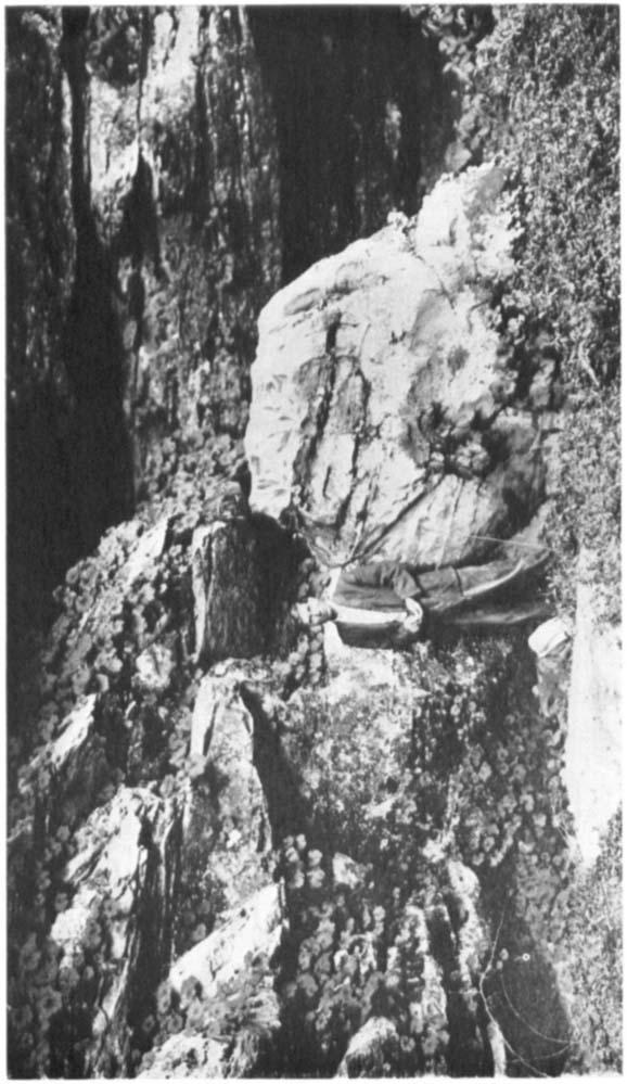
6 706 AMERICAN ANTHROPOLOGIST [N. ~.,31, feet deep and 150 feet across. The overhand which forms the roof of the shelter is a stream valley and a small waterfall flows over it. The hominy-hole is in an exposed ledge, which is level with the floor on one side and 2 feet high on the other. The hole is 5 inches in diameter and 1 foot, 2 inches deep. A stone plug was found in the bottom of the hole. 9. Hardin county. Three and one-half miles south of Howe s vallcy. On farm of J. W. Love. A series of clifis running roughly east and west contain a number of good shelters on the south face. The largest of these shelters, which is30 feet deep, 120 feet long, and 40 feet high, contains two hominy-holes, both on the sloping rock floor. Both holes when visited were entirely hidden beneath a luxuriant growth of poison ivy. The larger hole measured lltx88 inches in diameter at the top and was 2 feet deep. The smaller hole was 7 feet, 8 inches east of the other and higher up on the slope. It measured 5x4 inches in diameter and 133 inches deep. PROBABLE METHOD OF GRINDING There are to be found in Kentucky, in considerable number, four types of stone pestles as shown in plate 58. Three of these types, a, b, and c, are common to all parts of the State, except the region under discussion. They are, however, not found under cliffs and rock shelters or in association with hominy-holes. These forms may be described briefly as (a) bell-shaped pestles, to be used in grinding in a lap-stone mortar; (b) short, cylindrical pestles, also used in hand mortars, and (c) specialized ellipsoidal river pebbles, to be used on rubbing stones. All of these pestles show the result of use, the grinding process producing a smooth surface on the base of the bell pestle, on both ends of the cylindrical form, and on the oval surface of the pestles used on the rubbing stone. These forms were therefore used to grind grain by sliding or rolling over the surface of the mortar. Plate 5Xd is the only type of pestle found in association with the hominy-holes. The specimen figured was taken at a depth of seven feet from a trench about the base of the large boulder having a hominy-hole in its top, under Cow Cliff, Hardin county, as previously described. This pestle was near the original floor level of the rock shelter, resting on sandstone. Sassafras growing on the sides of the cliff had sent its roots some twenty feet along the old floor of the sandstone shelter and had wrapped themselves about the pestle, which is of limestone. They had thus etched their
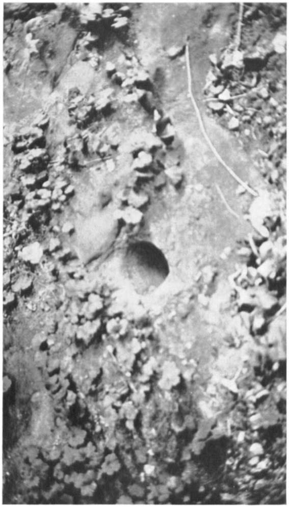
7 WEBB AND PUNKHOUSER~ HOMINY-HOLES OF KENTUCKY 70; pattern on its surface. However, quite enough of the original artifact remains to indicate that this type of pestle is quite different in use from the ordinary bell-shaped pestle used for grinding in mortars. The usual bell-shaped pestle is smooth on the base (the result of grinding) and generally rough on the handle. This hominy-hole pestle shows great wear over the pointed end and shaft and is rougher on the base. A careful investigation shows that every pestle found in association with hominy-holes is bellshaped, and worn by use on the point. This very strongly suggests that they were used in these hominy-holes, pointed end down. If so used, they crushed the grain not by grinding in the hole, but by percussion, being raised and allowed to fall. Thus is offered a simple explanation of how the hominy-hole was originally made and kept roughly conical in form and why it gets much deeper instead of larger with continued used. In general the diameter at the top is about the same (7 inches), no matter whether the hole be one foot or three feet deep. In fact many holes are found so deep that it must have been inconvenient to remove the meal after grinding. This might necessitate the starting of a new hole. As previously stated, holes an arm-length deep are often found in the immediate vicinity of smaller and newer holes-often in the same boulder. This would seem to indicate that the hole was worn deeper by continued percussion, the grain cracked by the impact, rather than by true grinding. It is apparent that an old hole would be more efficient in preventing the scattering of the material ground than a very shallow new hole, if the percussion method was used. It would therefore seem natural that primitive man here would use a hole as long as possible and would thus defer the time of starting a new hole in a given locality. When a hole became too deep to be convenient, it is quite natural that in some cases he would fit a plug in the bottom of the hole thus to raise the level of the bottom and make it possible to continue the use of this hole rather than start a new one. In seeking a plug for this purfose he v ould require a tight-fi tting plug, hard enough to stand the blows of a limestone pestle. It would be natural to
8 708 AMERICAN ANTHROPOLOGIST [N. S., 31,1929 use for this purpose a portion of a limestone pestle, which having been previously used (and probably broken) in the hole, would probably make a good fit, and would be as hard or harder than the sandstone about it. This seems to be the explanation of the finding by the authors of a number of hominy-holes, each quite deep, containing a plug of limestone at the bottom, the plug having clearly the appearance of a broken section of pestle (see pl. 47). The bell-shaped pestles under the cliffs near hominy-holes are from five to eight inches long. This would necessitate their attachment to a handle or shaft some three feet or more in length for use in the deeper holes. These pestles all show a concave depression in the base and in general one or more flattened sections on the rim of the bell, as if for attachment to such a handle. Under the Cundiff Cliff previously referred to there is a large boulder somewhat higher than a man, in the top of which are three hominy-holes. On the outer rim of this boulder there has been cut in the hard surface, a score or more of nearly vertical furrows, each about two inches in diameter, and extending from the top of the boulder over the rim and down the side where the furrow fades out. These grooves are about two inches deep at the deepest part. If from their position we may assume that they were made in the process of use of the hominy-hole, the process of grinding by percussion must offer an explanation of their product:on. It is well known that primitive man was well acquainted with the forces of elasticity and made use of them in settingsnares, and in the bow. If he could have bent down a young sapling growing near this boulder, or used the limb of an overhanging tree, the pestle and its shaft might have been attached and caused to move up and down by pulling the tree down and allowing it to spring upward. Such a simple mechanism would not have been beyond the ability of the primitive dwellers under these cliffs, and such a device would easily account for the grooveson the side of the boulder, as in order to pull down the tree limb it would be quite natural to attach to it a rope of grass, leather, or perhaps a wild grape vine, and as the pestle was caused to work up and down, this rope dragging over the edge of the boulder would saw out the furrows as found. While it may

9 c.3 I a.3.
10
11 C.e 0 Y
12
13 [WISRR-PUNKIIOIJSEK] PLATE 45
14

15 AYERICAN ANTHRCJPOLOCIST, N. s., VOL. 31
16

17 a; I 0 c a, 5 c. Ld.- c M.4 B 5
18
19 [WEUB-PUNKHOUSE:K] PLATE 48
20
21
22

23 AMERICAN ANTIIROI OLO(;IST, N. S., VOL. 31 [WEBB -I? UTPU KHO USR 111 PLATli 50 c W F b
24

25 AM1:RICAN ANTIIROPOI.OCIST, N. S., \'ClL C
26

27 AMERIC'AN AKTIIROPOLOCIST, N. S., LOL.
28

29 AMERICAN ANTIIROPOLO(;lSl', N. S., VOL.,3l
30
31 d c
32
33
34
35 [Wl?BB-FUNKAOUSER] PLATE 56
36
37 [WEBB-FUNKAOUSER] PLATE 57 e, 5
38

39 AMERICAN ANTIIROPOLOCIST, N. S., VOL. 3 1 c
40
![WEBB AND PUNKEOUSER] HOMINY-HOLES OF KENTUCKY 709 not be positively proven that this method was actually employed, there seems nothing in the position of the holes, the grooves, or the boulder which](/docs-images/87/96626488/images/41-0.jpg "would interfere with the employment of such a process.")
41 WEBB AND PUNKEOUSER] HOMINY-HOLES OF KENTUCKY 709 not be positively proven that this method was actually employed, there seems nothing in the position of the holes, the grooves, or the boulder which would interfere with the employment of such a process. In conclusion, from the investigation of these hominy-holes and the pestles associated with them, the authors believe that here is to be found a unique method of grinding by percussion, using a bell-shaped pestle, point downward, in the hominy-hole. So far as is known no such method of grinding has been previously reported from outside the tributaries of the Green river. Whether or not this method of grinding may be one of the distinguishing characteristics of a distinct culture, or only a local variation of the well-known lap stone mortar, remains yet to be determined. UNIVERSITY OF KENTUCKY, LEXINGTON, KENTUCKY
A TOPOGRAPHIC FEATURE OF THE HANGING VALLEYS OF THE YOSEMITE.
 A TOPOGRAPHIC FEATURE OF THE HANGING VALLEYS OF THE YOSEMITE. THE larger hanging valleys around the Yosemite valley have topographic features in common that are interesting in themselves, and they likewise
47I THE LAS ANIMAS GLACIER.
 THE LAS ANIMAS GLACIER. ONE of the largest of the extinct glaciers of the Rocky Mountains was that which occupied the valley of the Las Animas river. This stream originates in the San Juan mountains in
Architectural Analysis in Western Palenque
 Architectural Analysis in Western Palenque James Eckhardt and Heather Hurst During the 1999 season of the Palenque Mapping Project the team mapped the western portion of the site of Palenque. This paper
Looking north from the SW shieling site with Lub na Luachrach in the foreground
 Looking north from the SW shieling site with Lub na Luachrach in the foreground Upper Gleann Goibhre - Shieling sites Two shieling sites in the upper reaches of the Allt Goibhre were visited and recorded
Introduction to Africa
 Introduction to Africa Did you know? Africa has more countries than any other continent. The Sahara is a desert that is the size of the U.S. It s the world's largest desert. Most of the world s gold and
Lake Wissota Access Locations within the LaFayette Township. By Chad Martin
 Lake Wissota Access Locations within the LaFayette Township By Chad Martin Anson/ Wissota Access Point # 1 Road: 195 th St. Associated Fire Numbers: 13294 Defining Characteristics: Forested from road
4. Bronze Age Ballybrowney, County Cork Eamonn Cotter
 4. Bronze Age Ballybrowney, County Cork Eamonn Cotter Illus. 1 Location map of the excavated features at Ballybrowney Lower (Archaeological Consultancy Services Ltd, based on the Ordnance Survey Ireland
Provincial Archaeology Office Annual Review
 2017 Provincial Archaeology Office Annual Review Provincial Archaeology Office Department of Tourism, Culture, Industry and Innovation Government of Newfoundland and Labrador March 2018 Volume 16 A brief
IMTO Italian Mission to Oman University of Pisa 2011B PRELIMINARY REPORT (OCTOBER-DECEMBER 2011)
") IMTO Italian Mission to Oman University of Pisa 2011B PRELIMINARY REPORT (OCTOBER-DECEMBER 2011) The 2011B research campaign took place in the area around Salut from October, 19 th, to December, 16 th.
IMTO Italian Mission to Oman University of Pisa 2011B PRELIMINARY REPORT (OCTOBER-DECEMBER 2011) The 2011B research campaign took place in the area around Salut from October, 19 th, to December, 16 th.
GLACIER STUDIES OF THE McCALL GLACIER, ALASKA
 GLACIER STUDIES OF THE McCALL GLACIER, ALASKA T John E. Sater* HE McCall Glacier is a long thin body of ice shaped roughly like a crescent. Its overall length is approximately 8 km. and its average width
Development and performance of the common Keren Stove Yogyakarta, November 2012 March C Pemberton Pigott
 Development and performance of the common Keren Stove Yogyakarta, November 2012 March 2013 C Pemberton Pigott 1. Overview: 1.1. The Keren stove is the most common single pot cooking device in Central Java.
THE HEUGH LINDISFARNE
 LINDISFARNE COMMUNITY ARCHAEOLOGY THE HEUGH LINDISFARNE Archaeological excavations in June 2017 Invitation to volunteers THE HEUGH, LINDISFARNE, NORTHUMBERLAND: ARCHAEOLOGICAL EXCAVATIONS 2017 INTRODUCTION
Did It. naturalists. Young. Moving and melting ice shaped many of Minnesota s land features. 30 Minnesota Conservation Volunteer
 Young naturalists by Mary Hoff Photography by Gary Alan Nelson T he Glacier Did It Moving and melting ice shaped many of Minnesota s land features. Shut your eyes. Imagine that it s a sunny summer day
Wicklow Mountains Path Survey
 Wicklow Mountains Path Survey Glenmacnass Tonelagee Start to Finish: O 114 030 to O 085 016 Altitude (lowest highest): 370m 817m Weather: Sunny day, hot Access: Military Road, Glenmacnass Surveyed by:
FOUNDATIONS OF ARCHAEOLOGY A WALK IN VERNDITCH CHASE
 FOUNDATIONS OF ARCHAEOLOGY A WALK IN VERNDITCH CHASE 1. A Tale of two Long Barrows Long barrows were constructed as earthen or drystone mounds with flanking ditches and acted as funerary monuments during
Lordenshaw. What are cup & ring marks?
 Lordenshaw Lordenshaw hill has one of the largest clusters of ancient cup and ring marked stones in the UK. We ve chosen four interesting spots we d like to share with you. What are cup & ring marks? The
AN ARCHAEOLOGICAL ASSESSMENT OF BOERNE CITY PARK, KENDALL COUNTY, TEXAS. Thomas C. Kelly and Thomas R. Hester
 AN ARCHAEOLOGICAL ASSESSMENT OF BOERNE CITY PARK, KENDALL COUNTY, TEXAS Thomas C. Kelly and Thomas R. Hester Center for Archaeological Research The University of Texas at San Antonio Archaeological Survey
Waterproof Debris Shelter
 Bushcraft Video Series: David Styles, creator of 'Deep Nature Mentoring' presents Waterproof Debris Shelter Transcript Of Video 1. How Do We Make A Debris Shelter? Today we are going to learn about how
MONTEVECCHIA Pyramid Hills.. Summary 9 pages
 Gabriela Lukacs, Mag.rer.soc.oec., graduate Vienna university Post graduate art +history university Siena, Italy Participant of the excavations in Visoko, Bosnia since 2006 Grinzinger Allee 15, 1190 Wien,
HYDROLOGY OF GLACIAL LAKES, FORT SISSETON AREA
 PROC. S.D. ACAD. SCI., VOL. 77 (1998) 59 HYDROLOGY OF GLACIAL LAKES, FORT SISSETON AREA Perry H. Rahn Department of Geology & Geological Engineering South Dakota School of Mines and Technology Rapid City,
Photographing Upper Peninsula Waterfalls
 Photographing Upper Peninsula Waterfalls Tod Poirier Freelance Photographer Photography is one of my passions. The following spread showcases several Upper Peninsula waterfalls. At times a single drop
Difficult Run Stream Valley Park
 Difficult Run Stream Valley Park The more intense mountain bikers have known about for Difficult Run for some time. Equestrians have known it longer. Eight miles of unpaved trail, the Rails to River Trail
MP : The Big Chief Overlook and the Glen
 MP 253 254: The Big Chief Overlook and the Glen The mile between MP 253 and 254 has lots of history in it. It includes the only recorded remains of the Victory Highway on the Clear Creek County side of
Lidar Imagery Reveals Maine's Land Surface in Unprecedented Detail
 Maine Geologic Facts and Localities December, 2011 Lidar Imagery Reveals Maine's Land Surface in Unprecedented Detail Text by Woodrow Thompson, Department of Agriculture, Conservation & Forestry 1 Introduction
Ground Penetrating Radar Survey Report:
 Ground Penetrating Radar Survey Report: German Hospice in Jerusalem, Israel Data Acquired June 19, 2003 Report compiled August 26, 2003 Survey and Report Published by Mnemotrix Systems, Inc. Copyright
CWMGIEDD FROM ABERCRAVE
 Abercrave to Cwmgiedd Walk Page 1 Starting from The Abercrave Inn. Grid Ref: SN 824128 From the Abercrave Inn, an 11.3km (7 miles) walk to the foothills of the Cribarth Mountain, then through forest to
Blanco Creek Ranch Acres, Uvalde County, Texas
 Blanco Creek Ranch 1208.30 Acres, Uvalde County, Texas James King, Agent Office 432 426.2024 Cell 432 386.2821 James@KingLandWater.com Blanco Creek Ranch 1208.30 acres Uvalde County, Texas James King,
Other Agencies and Organizations
 Daniel Boone National Forest 1700 Bypass Road WInchester, KY 40391 859-745-3100 Location Northern terminus is near Morehead, Kentucky. Southern terminus is located in the Big South Fork NRRA in Tennessee.
Darwin s gigantic blunder
 Trail Darwin s gigantic blunder Explore how ice shaped the landscape and why Charles Darwin made a nice mess of Glen Roy Time: 1hr 10 mins Distance: 2 miles Landscape: rural At Glen Roy a curious feature
Central Overland Trail Utah & Nevada Driving Guide, First Edition, 2016
 Central Overland Trail Utah & Nevada Driving Guide, First Edition, 2016 Page 51 In the third paragraph, second sentence, change 0.4 miles to 0.1 miles. In the fourth paragraph, second sentence, change
Trail Assessment Report
 Trail Assessment Report Trail Options for the Bear Creek Canyon located in Pikes Peak Ranger District, Pike National Forest and on Colorado Springs Utility Lands Due to the presence of a unique species
Student Reading 13.10: The Regions of Ohio
 Student Reading 13.10: The Regions of Ohio Ohio has five natural regions which formed more than 10,000 years ago. A natural region is an area that shares the same natural features. These places have similar
Camp Jack Wright PERMANENT ORIENTEERING COURSE (2004)
") Camp Jack Wright PERMANENT ORIENTEERING COURSE (2004) WHAT IS ORIENTEERING? The skill which enables a person to navigate with a map. In the competitive sport, the winner is the person who finishes in the
Camp Jack Wright PERMANENT ORIENTEERING COURSE (2004) WHAT IS ORIENTEERING? The skill which enables a person to navigate with a map. In the competitive sport, the winner is the person who finishes in the
Marilla Reservoir to Chestnut Ridge via Marilla Trails and Bullis Hollow Trail east to west
 USGS topographic maps useful to this hike are the Bradford and Stickney 7.5 minute sectionals. These notes are designed to assist in identifying distance and location using geophysical and man-made characteristics
Orienteering. The fundamental outdoors skill!
 The fundamental outdoors skill! Orienteering Nothing will make you feel more confident in the out of doors like knowing how to find your way in the woods. Orienteering Prepared by: Jeffrey Lybarger Assistant
CULTURAL HERITAGE RESOURCES IMPACT ASSESSMENT ON MALOKONG HILL
 CULTURAL HERITAGE RESOURCES IMPACT ASSESSMENT ON MALOKONG HILL AFRICAN HERITAGE CONSULTANTS CC 2001/077745/23 Tel/fax: (012) 567 6046 Cell: 082 498 0673 E-mail: udo.heritage@absamail.co.za DR. UDO S KÜSEL
CENTER PIVOT TRACK MANAGEMENT OPTIONS
 Proceedings of the 28th Annual Central Plains Irrigation Conference, Kearney, Nebraska, February 23-24, 2016 Available from CPIA, 760 N. Thompson, Colby, Kansas CENTER PIVOT TRACK MANAGEMENT OPTIONS Steven
MAKE A TEEPEE. DESIGN CHALLENGE Construct a teepee large enough to sit in.
 Grades 3 5 45 minutes MAKE A TEEPEE DESIGN CHALLENGE Construct a teepee large enough to sit in. SUPPLIES AND EQUIPMENT Per working team: Newspaper (at least 90 sheets) 9" thin paper plates (at least 75)
There are actually six geographic sub-regions, three in both the uplands and the lowlands.
 6 Regions of AR Although Arkansas is most easily divided into two distinct geographical regions, the northwestern uplands and the southeastern lowlands, this description does not accurately portray the
Report of the Survey in the Wadi Abu Dom,
 Report of the Survey in the Wadi Abu Dom, 24.2.-16.3.2009 (funded by the Gerda Henkel-Foundation, Germany) Angelika Lohwasser Free University Berlin, Germany 1. Staff Gabriel, Prof. Dr. Baldur, Geographer,
Massanutten Mountain Cluster
 Massanutten Mountain Cluster Signal Knob Catback Mountain Southern Massanutten Mountain Five areas of almost 49,000 acres on the Lee Ranger District compose the Massanutten Mountain Cluster of Mountain
aiton.new 1/4/04 3:48 AM Page 2
 aiton.new 1/4/04 3:48 AM Page 2 Below: An aerial view of area A of the excavations. A massive square building that appears to be a fortress was discovered in this area at the top of the tell. aiton.new
Property access tracks
 Property access tracks Planning, location, construction and maintenance The need for farm roads and tracks The efficient running of a property depends on, among other things, ready access to various locations
The Yingtianmen Gate-site of the Sui and Tang Eastern Capital in Luoyang City
 Nandajie The Yingtianmen Gate-site of the Sui and Tang Eastern Capital in Luoyang City Tang Luoyang City-site Archaeological Team, Institute of Archaeology, Chinese Academy of Social Sciences Key words:
Note: Coordinates are provided as Universal Transverse Mercator UTM Zone U21, North American Datum 1983 (NAD 83).
.") Northern Traverse Route Description The Northern Traverse (formerly the North Rim Traverse) is an unmarked and rugged backcountry hiking route. It is known be a demanding hike, because of its terrain and
Northern Traverse Route Description The Northern Traverse (formerly the North Rim Traverse) is an unmarked and rugged backcountry hiking route. It is known be a demanding hike, because of its terrain and
beach. Make the ford and follow the trail out to the junction with Red Creek Tr in an open grassy area.
 Description: This is a moderate to slightly strenuous 22.8 mile backpack (add 2.6 miles if you do the packless out and back to the Lion s Head) that will have you exploring nearly every thing that is The
Region 1 Piney Woods
 Region 1 Piney Woods Piney Woods 1. This ecoregion is found in East Texas. 2. Climate: average annual rainfall of 36 to 50 inches is fairly uniformly distributed throughout the year, and humidity and temperatures
Another World, Underground: Carlsbad Caverns National Park
 Another World, Underground: Carlsbad Caverns National Park Welcome to This Is America with VOA Learning English. This week on our program, we explore a UNESCO World Heritage Site in the American Southwest,
Jeff at Bar 10, trikes and planes in background. My trike. Living room, dining room Bar 10 Lodge
 Monday, October 23, 2017 Cobra flight #609, PIC #622, 4 landings Zion Canyon, Bruce Canyon, Escalante, Stevens Arch, San Juan Goosenecks, Bluff Dirt Road I got a great night sleep, and woke up a little
SHELTER DESIGN: IGLOO SNOW SHELTER
 CONSTRUCTION: CHALLENGING 2 to 3 hours for two people. EQUIPMENT: Sawing instrument SEASON: Winter The Igloo shelter is not a shelter that should be built in an emergency situation as they are hard to
Trench 91 revealed that the cobbled court extends further to the north.
 Report on the 2013 Gournia Excavations The 2013 excavations at Gournia were conducted June 17 July 26 under the aegis of the American School of Classical Studies at Athens and the supervision of the KD
Plates. Kom Firin I 193. Plate 96 View of the southwestern part of Kom Firin, looking west-southwest.
 Plates Plate 96 View of the southwestern part of Kom Firin, looking west-southwest. Plate 97 Ramesside temple: wall 0157 and clean sand 0189 (TG), view to north. Plate 98 Ramesside temple: wall 0135 (TD),
BASIC FIRE PRINCIPLES SITE SELECTION AND PREPARATION
 FIRECRAFT In many survival situations, the ability to start a fire can make the difference between living and dying. Fire can fulfill many needs. It can provide warmth and comfort. It not only cooks and
ARDESTIE EARTH HOUSE HISTORIC ENVIRONMENT SCOTLAND STATEMENT OF SIGNIFICANCE. Property in Care no: 24
 Property in Care no: 24 Designations: Scheduled Monument (SM90021) Taken into State care: 1953 (Guardianship) Last reviewed: 2004 HISTORIC ENVIRONMENT SCOTLAND STATEMENT OF SIGNIFICANCE ARDESTIE EARTH
Self-Guided Walk Langdale Pikes. Start & Finish: NT car park (free to members) at Sticklebarn - on the right just beyond the New Dungeon Ghyll hotel.
 at Sticklebarn - on the right just beyond the New Dungeon Ghyll hotel.") Self-Guided Walk Langdale Pikes Key Information These mountains form a collection of spires and cliffs on the north side of Langdale. This walk visits four of the main tops Pavey Ark, Harrison Stickle,
Self-Guided Walk Langdale Pikes Key Information These mountains form a collection of spires and cliffs on the north side of Langdale. This walk visits four of the main tops Pavey Ark, Harrison Stickle,
The gorges of Mohican Park in Ohio create a hiker's paradise Sunday, May 22, 2011 By Bob Downing, Akron Beacon Journal
 Pittsburgh Post-Gazette The gorges of Mohican Park in Ohio create a hiker's paradise Sunday, May 22, 2011 By Bob Downing, Akron Beacon Journal Bob Downing Big Lyons Falls drops 80 feet into a shady U-shaped
A Possible Roman Road Discovered in Lanarkshire
 A Possible Roman Road Discovered in Lanarkshire In the eighteenth century, William Roy documented the Roman road network that provided communication between the Castledykes fort (near Carstairs, Lanarkshire)
Guide Book Excerpts. Wham Ridge 2006
 Guide Book Excerpts Wham Ridge 2006 Approach: Molus Lake / Elk Park / Vestal Creek Roach and Roach Description Take the Durango & Silverton Narrow Gauge train from either Durango or Silverton and get off
Visitors enter the pages of history, meeting each of these women via large format photographs and a short biography.
 Freedom s Sisters (2,500 ft. 2, premiered March 2008 at Cincinnati Museum Center) An exhibition created by Cincinnati Museum Center, organized for travel by Smithsonian Institution Traveling Exhibition
Control Description Sheet 1
 Control Description Sheet 1 Headings I0A Example M20 M21 M35 1 8.8km 250m Event Title Classes (optional) Course Code; Course length, Height climb Start location as if it was a control. First Control Description
The Appleton Wetland; Its Decline, Cause and Recommended Action. Appendix K: Wetland Inspection
 The Appleton Wetland; Its Decline, Cause and Recommended Action Appendix K: Wetland Inspection Report prepared by Appleton Wetland Research Group of the Mississippi Valley Field Naturalists Research Group
BRONZE-AGE FOOD VESSEL (b) USED AS A BURIAL URN BROWN CANDOVER, [To face page 249]
![BRONZE-AGE FOOD VESSEL (b) USED AS A BURIAL URN BROWN CANDOVER, [To face page 249]](/thumbs/93/118018967.jpg "BRONZE-AGE FOOD VESSEL (b) USED AS A BURIAL URN BROWN CANDOVER, [To face page 249]") BRONZE-AGE FOOD VESSEL (b) USED AS A BURIAL URN BROWN CANDOVER, HANTS [To face page 249] 249 TWO BRONZE AGE DISCOVERIES IN HANTS. BY S. E. WlNBOLT, M.A. (i.) Brown Candover. East of the road at Brown Candover,
BRONZE-AGE FOOD VESSEL (b) USED AS A BURIAL URN BROWN CANDOVER, HANTS [To face page 249] 249 TWO BRONZE AGE DISCOVERIES IN HANTS. BY S. E. WlNBOLT, M.A. (i.) Brown Candover. East of the road at Brown Candover,
Hole in the Rock Scenic Backway
 Hole in the Rock Scenic Backway The Hole in the Rock Scenic Backway leads one along the pioneer path created by a Mormon Expedition. Approximately 55 miles one-way from Highway 12 to the Hole-inthe-Rock,
Gifts of the Glaciers
 Gifts of the Glaciers Gifts of the Glaciers Moving ice of glacier was responsible for water, landforms, and soil characteristics and patterns of today Sculpturing of bedrock materials Glacial Landforms
Big Sable Point Lighthouse Les & Arlene Meverden Ludington, MI 49431
 Les & Arlene Meverden Ludington, MI 49431 My Interview with Les and Arlene Meverden and their daughter Janet was held on June 5, 2004. I first learned about the Meverden family through an article published
United States Department of the Interior National Park Service. Boundary Expansion Listed in National Register January 11, 2017
 NPS Form 10900-a (Rev. 8/2002) OMB No. 10240018 United States Department of the Interior National Park Service Boundary Expansion Listed in National Register January 11, 2017 National Register of Historic
Axe and Saw Permit: Safe Use of Axes
 Page 1 of 7 Objective: The objective of this workshop guide is for the Scout Leader and/or Scout youth to be able to describe and demonstrate safe use of the Axe. Axe or Hatchet: What s the difference?
Mt Kuring-gai Track to Berowra station
 Mt Kuring-gai Track to Berowra station 4 hrs 15 mins 9.7 km One way Hard track 4 553m This walk explores three valleys, with great displays of wild flowers in spring, and some nice sandstone overhangs.
CRANBERRY. Introduction
 Introduction Introduction The Cranberry Boulders are a group of 60 problems set in a beautiful mossy forest above the Cranberry Creek. The boulders are located approximately 36km south of Revelstoke on
Subject to sale, withdrawal, or error.
 The Crawford L Bar Ranch is located approximately 40 air miles west of Albuquerque, New Mexico. This ranch truly epitomizes the description of New Mexico being the Land of Enchantment. The topography and
Route #2) Mt. Massive - Southwest Slopes
 Mt. Massive - Southwest Slopes") Route #2) Mt. Massive - Southwest Slopes Difficulty: Class 2 Ski: Advanced, D6 / R2 / III Exposure: Summit Elevation: Trailhead Elevation: Elevation Gain: Round-trip Length: Trailhead: County Sheriff:
Route #2) Mt. Massive - Southwest Slopes Difficulty: Class 2 Ski: Advanced, D6 / R2 / III Exposure: Summit Elevation: Trailhead Elevation: Elevation Gain: Round-trip Length: Trailhead: County Sheriff:
Geologic Trips, Sierra Nevada
 ISBN 0-9661316-5-7 GeoPress Excerpt from Geologic Trips, Sierra Nevada by Ted Konigsmark All rights reserved. No part of this book may be reproduced without written permission, except for critical articles
Specification for Grip blocking using Peat Dams
 Technical Guidance Note 1 Specification for Grip blocking using Peat Dams 1. Introduction Moorland drains (grips) have been dug across much of the Yorkshire upland peatlands. Many of these grips have become
Caitlin Pugh November 7 th, 2013 Technical Description Assignment
 Caitlin Pugh November 7 th, 2013 Technical Description Assignment 1. General Description The Swing-A-Way can opener is a handheld mechanical device used to open cans of all sizes. This device is a common
The Tel Burna Archaeological Project Report on the First Season of Excavation, 2010
 The Tel Burna Archaeological Project Report on the First Season of Excavation, 2010 By Itzick Shai and Joe Uziel Albright Institute for Archaeological Research Jerusalem, Israel April 2011 The site of
Discipline / Subject: Geography, STEM. Topic: Topographic Maps, Augmented Reality. Grade Level: 3-6; others with modifications
 Building the Trail: Augmented Reality Topographic Trail Map Developed by: Jen Reiter, 2014 Iditarod Teacher on the Trail Created February, 2018 Barry James, Science Teacher Discipline / Subject: Geography,
Outdoor Education Worksheets
 Outdoor Education Worksheets OUTDOORS You will need: First Aid Kit Appropriate clothing for whole group (sunny/wet weather) Charged mobile phones and appropriate numbers of adult helpers in case of group
Mighty Glaciers. Mighty Glaciers. Visit for thousands of books and materials.
 Mighty Glaciers A Reading A Z Level M Leveled Reader Word Count: 684 LEVELED READER M Mighty Glaciers Written by Ned Jensen Visit www.readinga-z.com for thousands of books and materials. www.readinga-z.com
New Studies in the City of David The Excavations
 The 2013-2014 Excavations Israel Antiquities Authority The intensive archaeological work on the city of David hill during the period covered in this article has continued in previously excavated areas
Installing a Drainage Chimney. Written by Nevin Sunday, 28 May :35 - Last Updated Tuesday, 18 July :52
 Many, many years ago when we put the first tanks on the back of the garage, the council inspector had said that I needed to put in a rubble drain to take the stormwater from the roof of the garage. This
5 MAP SPECIFICATION FOR SKI-ORIENTEERING
 5 MAP SPECIFICATION FOR SKI-ORIENTEERING 5.1 General Maps for ski orienteering are based on the specifications for foot-orienteering maps. However in order to meet the specific requirements put on the
1/ Clatterjack 7a * SDS under right side of the roof. Out to lip, left to the arête and up before stepping back right to finish
 14 Crow Crag The potential of Crow Crag has gradually come to light though lines still remain unexplored. Despite the woodland location the excellent rock dries pretty quickly and there are some strong
1 Glacial Erosion and
 www.ck12.org Chapter 1. Glacial Erosion and Deposition CHAPTER 1 Glacial Erosion and Deposition Lesson Objectives Discuss the different erosional features formed by alpine glaciers. Describe the processes
Typical avalanche problems
 Typical avalanche problems The European Avalanche Warning Services (EAWS) describes five typical avalanche problems or situations as they occur in avalanche terrain. The Utah Avalanche Center (UAC) has
Hong Kong Bouldering. Steven Yip treading a Rocky Road (V6). Photo: Stuart Millis. HongKongClimbing.com. Page 36
. Photo: Stuart Millis. HongKongClimbing.com. Page 36") Hong Kong Bouldering Steven Yip treading a Rocky Road (V6). Photo: Stuart Millis Page 36 S hek Lung Kung General A fine set of boulders on very high friction rock. This area has the added bonus of a stunning
Hong Kong Bouldering Steven Yip treading a Rocky Road (V6). Photo: Stuart Millis Page 36 S hek Lung Kung General A fine set of boulders on very high friction rock. This area has the added bonus of a stunning
What Is An Ecoregion?
 Ecoregions of Texas What Is An Ecoregion? Ecoregion a major ecosystem with distinctive geography, characteristic plants and animals, and ecosystems that receives uniform solar radiation and moisture Sometimes
Glacial Geomorphology Exercise
 James Madison University Field Course in western Ireland Glacial Geomorphology Exercise 3-day road log (abbreviated) Striations Large kame terrace Cirque with moraines Kame delta Striations Eskers Raised
APPENDIX D: SUSTAINABLE TRAIL DESIGN. APPENDICES Town of Chili Parks and Recreation Master Plan Update
 APPENDIX D: SUSTAINABLE TRAIL DESIGN APPENDICES Town of Chili Parks and Recreation Master Plan Update Sustainable Trail Construction Sustainable trails are defined by the US Forest Service as trails having
Holyport Manor Special School, Highfield Lane, Cox Green, Maidenhead, Berkshire
 Holyport Manor Special School, Highfield Lane, Cox Green, Maidenhead, Berkshire An Archaeological recording action For CgMs Consulting by Jennifer Lowe Thames Valley Archaeological Services Ltd Site Code
Ranchers, Rattlers and Recharge
 Ranchers, Rattlers and Recharge Caving on the Phillips Ranch in Crockett County, West Texas By Sofia Casini Photos by Goeff Hoese and Peter Sprouse Participants: Don Arburn, Peter Sprouse, Ryan Reid, Geoff
Operation Manual SUPER BEAST Multi-tool SC-11M-10
 Operation Manual SUPER BEAST Multi-tool SC-11M-10 Technical Specifications General Safety/Operating Instructions Attaching/Changing the Head Using the SUPER BEAST as a Cutter Using the SUPER BEAST as a
MOAB Multi-Day (update ) RUN ANNOUNCEMENT
 RUN ANNOUNCEMENT") MOAB Multi-Day (update 02-06-18) RUN ANNOUNCEMENT RUN FULL NO MORE RSVPs ACCEPTED Date: March 31st to April 6th 2018 Trail Leader: Mike Wallace (714) 504-8514 Max Vehicle Limit Reached Meeting Tims: To
MOAB Multi-Day (update 02-06-18) RUN ANNOUNCEMENT RUN FULL NO MORE RSVPs ACCEPTED Date: March 31st to April 6th 2018 Trail Leader: Mike Wallace (714) 504-8514 Max Vehicle Limit Reached Meeting Tims: To
TIPI SET UP INSTRUCTIONS 9 24 SIZE
 TIPI SET UP INSTRUCTIONS 9 24 SIZE You have purchased the most authentic, best-constructed tipi on the market. Before getting started, take a few moments and read this booklet completely!! You re about
The Year in Review 2014, Beothuk Institute Inc. We have had several highlights this year. At the AGM in May there were two guest speakers, Dale
 The Year in Review 2014, Beothuk Institute Inc. We have had several highlights this year. At the AGM in May there were two guest speakers, Dale Jarvis set the stage for the story gathering that the Beothuk
Easy Open Pull Tab. Submitted to the Italian Packaging Technology Competition. March 15, Brian Calcagno. Teresa Haynes Hatfield.
 Easy Open Pull Tab Submitted to the Italian Packaging Technology Competition March 15, 2006 Brian Calcagno Teresa Haynes Hatfield Josh Taylor California Polytechnic State University, San Luis Obispo PROBLEM
You can also park on the side of the highway for a shorter approach; if you don t mind having your car towed. I was ticketed once and towed once.
 ARBUTUS GROVE Good problems, good views and closer than Squamish make this an attractive climbing spot for a few hours of fun. The freeway makes it a little noisy. Low vegetation (due to power line clearing)
Instruction Manual. A step-by-step guide to building your own igloo. Andy Meldrum All rights are reserved.
 Instruction Manual A step-by-step guide to building your own igloo. Andy Meldrum 2007 1 Contents 1 Introduction 2 Get properly kitted up. 3 Choose and prepare your site. 4 Create the base. 5 Mark out the
Leptis Magna. 9 LEPTIS MAGNA s NORTH COAST
 9 LEPTIS MAGNA s NORTH COAST The following observations were made on August 24, 25 and 26, 2000, thanks to the kind hospitality of the late Professor André Laronde during his year 2000 campaign of the
Evaluation Report 569
 Printed: March 1988 Tested at: Lethbridge ISSN 0383-3445 Group Evaluation Report 569 Vern Seed Boot and Banding Knife A Co-operative Program Between ALBERTA FARM MACHINERY RESEARCH CENTRE PAMI PRAIRIE
IAS Prelims Exam: Ancient History NCERT Questions: The Harappan Civilisation Set II
 IAS Prelims Exam: Ancient History NCERT Questions: The Harappan Civilisation Set II Questions asked from Ancient Indian History section in IAS Prelims Exam are quite easy but the candidates need to memorise