Tools and Technology for Accessible Trails
|
|
|
- Antony Griffin
- 5 years ago
- Views:
Transcription

1 Tools and Technology for Accessible Trails Peter Axelson Jeremy Vlcan Beneficial Designs, Inc. Minden, Nevada
2 What makes a trail accessible? Providing trail access information Preventing access barriers Improving trail surfaces Protecting the environment Meets accessibility guidelines
3 Access Guidelines Architectural Barriers Act Accessibility Guidelines (ABAAG) U.S. Forest Service Guidelines (FSORAG) Scope Trails Outdoor Recreation Access Routes Outdoor Recreation Elements
4 Access Guideline Characteristics -Surface -Openings -Tread Obstacles -Running Slope -Rest Intervals -Clear Tread Width -Protruding Objects -Passing Space -Cross Slope -Edge Protection
5 Four General Exceptions for ABAAG: Exception 1 Where compliance would cause substantial harm to cultural, historic, religious, or significant natural features or characteristics
6 Exception 2 Where compliance would substantially alter the nature of the setting or the purpose of the facility, or portion of the facility
7 Exception 3 Where compliance would require construction methods or materials that are prohibited by federal, state, or local regulations or statutes
8 Exception 4 Where compliance would not be feasible due to terrain or the prevailing construction practices
9 Surface-ADDAG Trail Firm and Stable ORAR Firm and Stable
10 Measurement of Surface Firmness and Stability Rotational penetrometer developed to objectively measure surfaces Portable device that can be used in the field Allows measurement of carpets, playgrounds and trail surfaces

11 Rotational Penetrometer Objective surface measurement device Draft Standard for measure of firmness and stability under development Available from Beneficial Designs
12 Rotational Penetrometer Readings Surface Firmness Stability Decomposed Granite Gravelpave Geoblock Envirogrid Geoweb EGA20 Geoweb
13 Rotational Penetrometer Readings-Gravelpave 2 Before Application After Application Firmness Stability Firmness Stability Avg Avg 0.38
14 Clear Tread Width-ADDAG Trail ORAR 36 Minimum 36 Minimum 32 Exception 32 Minimum
15 Openings-ADDAG Trail Max ½ diameter ORAR Max ½ diameter Elongated openings Elongated openings ¼ sphere ¼ sphere
16 Protruding Objects-ADDAG Trail ORAR Less than 80 Less than 80
17 Tread Obstacles-ADDAG Trail ORAR Up to 2 Up to 1 Exception up to 3 Exception up to 2
18 Passing Space-ADDAG Trail At least 60 width ORAR At least 60 width 1,000 foot interval 200 foot interval Minimum minimum
19 Running Slope-ADDAG Trail ORAR 5% any distance 5% any distance 8.33% up to 200 ft 8.33% up to 50 ft 10% up to 30 ft 10% up to 30 ft 12.5% up to 10 ft
20 Cross Slope-ADDAG Trail ORAR 5% maximum 3.3% maximum
21 Rest Intervals-ADDAG Trail ORAR 60 length 60 length Slope less than 5% Slope less than 5% Wide as widest Wide as widest adjacent trail adjacent trail Segment segment
22 Edge Protection-ADDAG Trail ORAR 3 minimum height 3 minimum height Where provided Where provided
23 Outdoor Recreation Elements Picnic Tables Benches Restrooms Grills Water Fountains Showerheads
24 Assessment and Compliance Inventory existing facilities and infrastructure Determine compliance with existing ADAAG and Developed Outdoor Recreation facilities Create transition plan with goals and objectives for accomplishing access
25 Development of a Complete Outdoor Recreation Assessment Process Develop and validate a repeatable assessment process for all Outdoor Recreation Elements Create instructions and data collection forms to determine compliance Set up electronic data collection and data base for management of information
26 DORAP Deliverables Data collection forms with instructions Software to record and export data Tool kit for performing all measurements One day training course on DORAP Web based DORAP training course Combine with UTAP for comprehensive training
27 DORAP applies too Urban or rural trails of any type City, county and state parks Picnic and camping facilities Visitor centers and rest areas Any public area that has any Outdoor Recreation Elements
28 Picnic Table TD Measurements TW KD KD TH KH TD

29
30 Picnic Table
31 Picnic Table

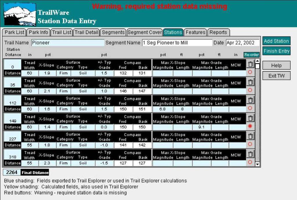
32 Measurement Comparisons
 Assessment must provide objective")
33 Provide Objective Information Moderate or Easy mean different things People have different abilities (young children, older adults, people with disabilities, unfit and inexperienced individuals) Assessment must provide objective information

34 Universal Trail Assessment Process


35 Universal Assessment Team

36 UTAP Tools


37 Key UTAP Information Length Grade Width Surface Cross slope Features & Facilities
38 UTAP Implementation Status Over 900 people trained to lead UTAP assessments Over 55 trainers to teach UTAP workshops State and agency-wide implementation is growing (AZ, MN, IN, NY, CA, FL) UTAP assessments available from consultants
39 Trailware Store and manage trail data Split, copy, reverse and combine trail segments into trails for processing Process data to generate grade, crossslope, tread width and surface reports Create Summary trail access information

40 Trail Cover Sheet with Data

41 Segment Cover Sheet with Data

42 Segment Data Collection Form with Data
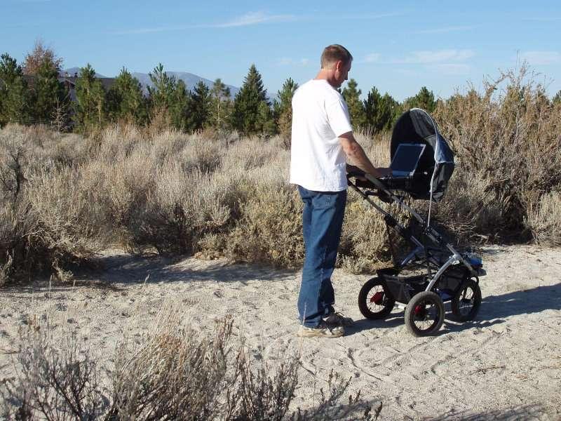
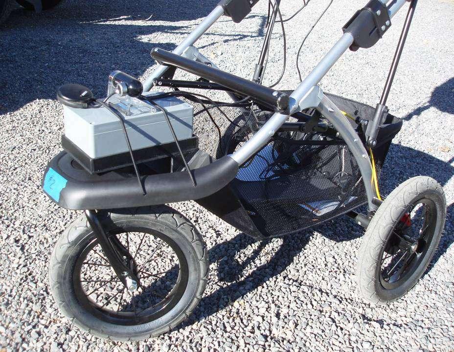
43

44
45 TrailWare Reports English or Metric units Data summaries: Grade, Cross Slope and Width Surface Category and Type Tread and Vertical Obstructions Trail Access Information

46 Station or Feature Log Report
47 Summary Tables for Typicals

48 Extreme Summary Tables
49 TrailWare Calculations Typical and extreme values for Grade, Cross Slope and Width Surface Category and Type Tread and Vertical Obstructions
50 Development Support Universal Trail Assessment Process Rotational Penetrometer and Trailware, trail data processing software All supported with funding from the NIH NICHD National Center for Medical Rehabilitation Research SBIR Program
51 Wheeled Instrumentation Sensor Package - WISP Stroller 3 wheeled jogging stroller with 22 inch wheelbase Rolawheel measures 13 inch width and 18 inch length ATV collects grades and x-slopes based on the vehicle wheelbase OHV same as ATV
52 HETAP-Stroller

53 HETAP- Rollawheel

54 HETAP- ATV
55 WISP Features One person operation to record grade and cross slope information Distance forward/reverse Standard USB sensor box interface Laptop with Weather resistant touch screen recommended Extra battery suggested
56 WISP Hardware High speed sampling and adjustable digital filtering of grade and cross slope Dual reed switches to sense forward and backward movement
57 HETAP-Stroller-GPS & Camera
58 WISP Software Interface Designed for ETRACS compatibility Component Object Module (COM) interface to request distance, grade and cross slope Calibration routine provided Compatible with HETAP 2.0 software
59 High Efficiency Trail Assessment Process - HETAP Software 2.0 Software that guides the user to collect objective surface and feature trail data Sort data to create grade, cross slope, surface and tread width reports SQL data base for compatibility with larger data base systems Calculation of Trail Access Information
60 HETAP 2.0 Station Data Automatic recording of grade, crossslope and distance Automatic capture of GPS position Automatic image capture Programmable alarms for grade and cross-slopes

61 Stations Screen
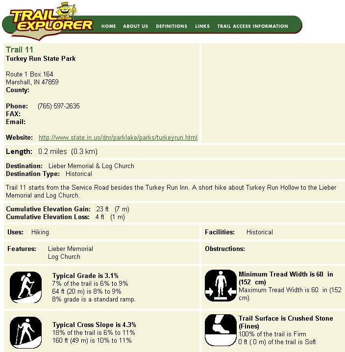
62 HETAP 2.0 Feature Data Feature type drop down lists Provides for recording of rotational penetrometer firmness/stability Image capture of features

63 Feature Screen

64 Rotational Penetrometer Screen
65 HETAP 2.0 System Features Data center to generate reports with sorting Combine, reverse and split trail segments for data processing Create TAI summary reports

66 Stations Data Report

67 Features Data Report
68 Trail Information Formats Trail Access Information - TAI Information sheets TAI Laminated strip decals Full panel signage with TAI TAI on Web Site

69 Internet Web Site

70 Trail Explorer.org
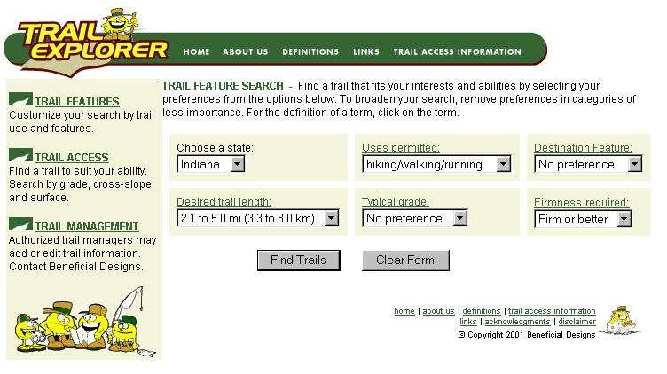
71

72
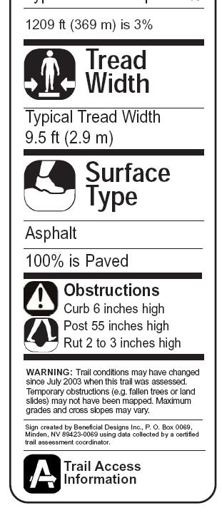
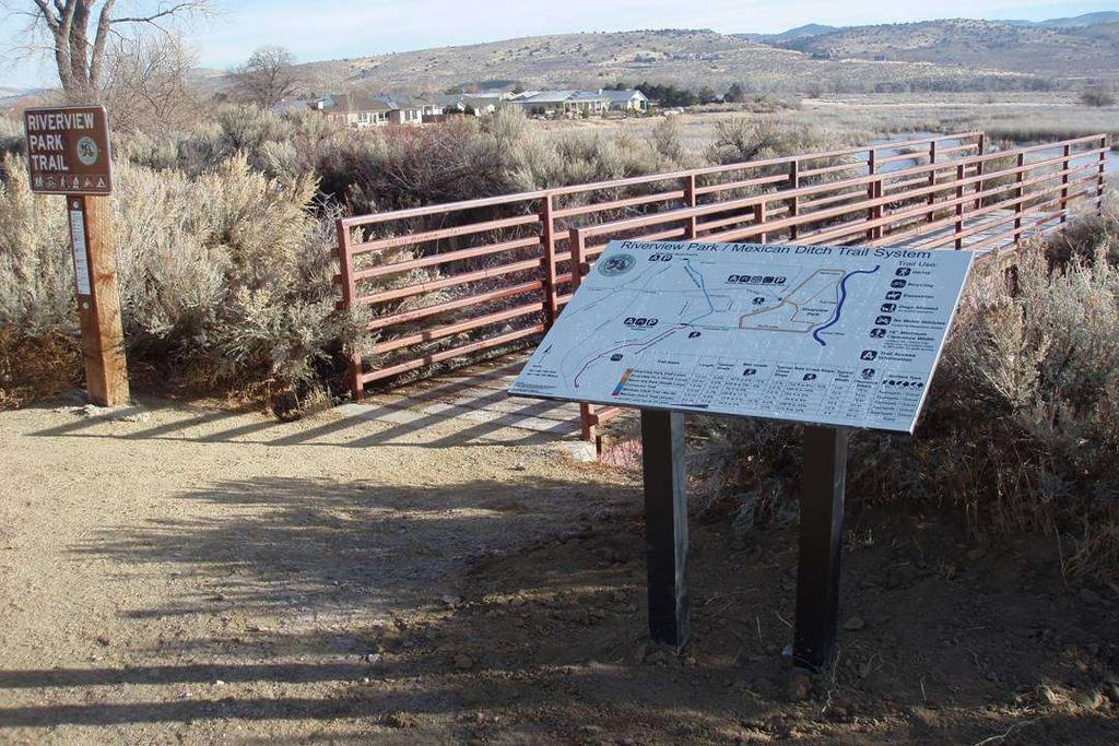
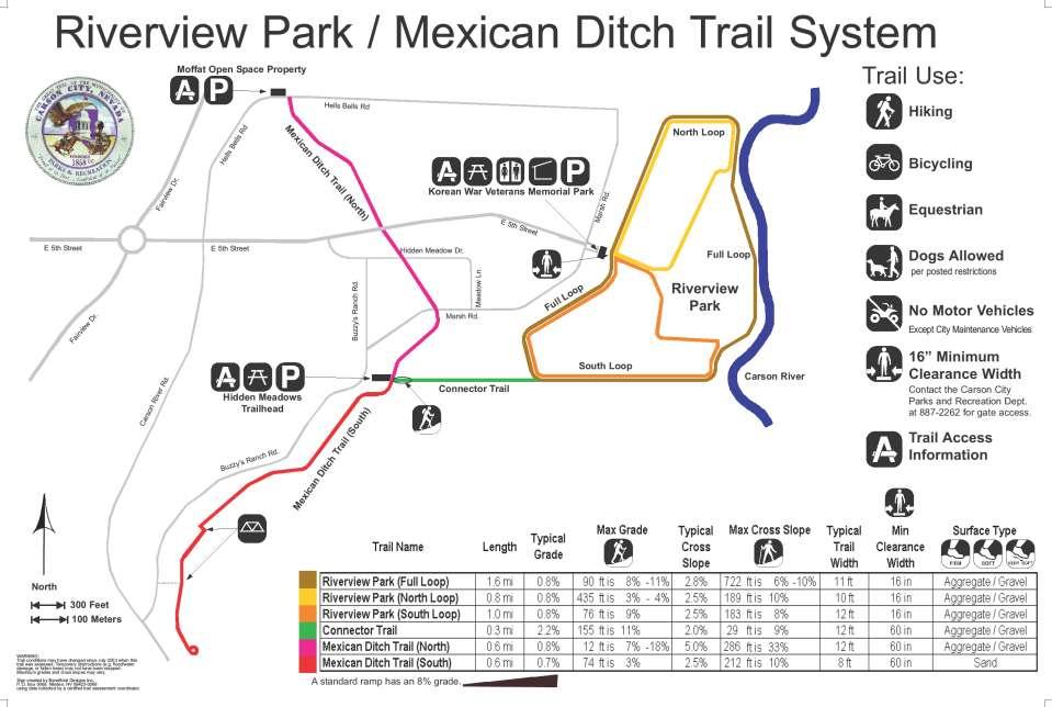
73
74 Pacific Crest Trail Eldorado Natio nal F orest TAI Trail Uses Hiking Dogs on Leash No Bikes Trail Length 1.1 mi (1.8 km) Linear trail Trail is part of the Pacific Crest National Scenic Trail and starts next to the seasonally open visitor center at Carson Pass. Restrooms are available at trailhead. A $3.00 parking charge is required to park and hike. Envelopes/depository for fee is present. An overnight camping permit is required if staying overnight. Several local and regional maps are displayed at the trailhead. Cumulative Elevation Change Gain 427 ft (130 m) Loss 82 ft (25 m) Information Sheet No Equestrians No Motorized Vehicles Hazards and Obstructions Step 30 Typical Grade is 8.5% 48% of the trail is between 8% and 22% 144 ft (44 m) is between 20% and 22% 8% grade is a standard ramp. Typical Cross Slope is 3.1% 20% of the trail is between 5% and 11% 226 ft (69 m) is between 8% and 11% Typical Tread Width is 49 in (124 cm) Tread Width ranges from 14 in (36 cm) to 100 in (254 cm) Rock 12 Root 6 Trail Access Information Trailhead Location Trail Surface is Soil 100% of the trail is Hard or better 5962 ft (1817 m) of the trail is Firm or better At Carson Pass on Highway 88 directly on north side of the seasonally Warning: Trail conditions may have changed since this trail was assessed. Temporary obstructions (e.g. fallen trees or land slides) may not have been mapped. Maximum grades and cross slopes may vary. Obstructions less than 6.0 in (15 cm) or outside the tread area 12 in wide by 120 in (3 m) high were not measured. Minimum clearance boundaries were at least 12 in high. This report has been generated by TrailWare which has been created by Beneficial Designs, Inc. Nov 28, 0


75 TAI lamina ted Strips
76 TAI Trail Signing Examples

77 TAI on Carsonite & Existing Signpost

78 TAI on Wooden Post


79 TAI on Narrow Trail/Logo Narrow Trails Color and Logos
80 Full Panel Signage Examples Trail Access Information Top view map for location information Agency Logo Locator information
81 Riverview Park Riverview Park
82
83

84
85

86
87
88 Funding Support Nevada Recreational Trails Program- Nevada Division of State Parks Administered by the Federal Highway Administration (FHWA) Safe, Accountable, Flexible, Efficient Transportation Equity Act: A Legacy for Users (SAFETEA-LU)
89 Preventing Access Barriers Need to provide access to all allowed user groups Need to prevent those user groups not allowed

90 Barrier at Riverview Park

91 Deschutes Cattle Guard Barrier

92 Kissing Gate Barrier

93 Single Step Barrier

94 Step Over Barrier

95 Stile Barrier

96 Latching Gate
97 Beneficial Designs Trail Gate Barrier Work
98 Motorcycle Side View

99 First Inverted Bollard Concept Motorcycle Testing

100 Second Inverted Bollard Concept Abilities EXPO

101 Third Inverted Bollard Concept Motorcycle Testing
102 Electronic Trail Gate Barrier Detect the presence of motorized trail vehicle at trail access entry Notify via phone or internet message Voice, image, text or GSM text message Report via alarm or dispatch service Capture of video before and after event Onsite alarm options

103 Electronic Gate Barrier
104 Electronic TGB Specifications Self contained wireless battery powered detection unit Base electronics receive signal via wireless protocol with jamming detection Low battery monitoring and notification
105 Electronic TGB Specifications Infra-red sensor technology with fresnel lens Field of view is approx 2 degrees At 50 feet the field of view is approx 20 inches Dynamic detection of hot objects entering field of view
106 Electronic Trail Gate Barrier Set up 32 inch clearance mechanical trail gate barrier with steel or concrete bollards Detect the presence of motorized trail vehicle at trail access entry point Silently report violation using desired format or onsite alarm
107 Electronic TGB Specifications Custom designed electronic circuit to control infra-red sensor Custom software algorithm to detect movement of heated object against background Detect the difference between hikers and count to monitor trail usage
108 Funding Support Development of the High Efficiency Trail Assessment Process and the Trail Gate Barrier Project provided by the USDA CREES SBIR program
109 Beneficial Designs, Inc. Minden, Nevada voice fax Working toward universal access through research, design & education
Peter Axelson. Beneficial Designs, Inc. Minden, NV
 Peter Axelson Beneficial Designs, Inc. Minden, NV Arroya Sit Ski Mono Ski Dynamic Seating Spring Assist Cross Country Ski Hand Bike Adaptive Canoe Seating Available from Chosen Valley Canoe Accessories
Who is Beneficial Designs?
 Who is Beneficial Designs? Beneficial Designs works towards universal access through research, design, and education. We believe all individuals should have access to the physical, intellectual, and spiritual
Outdoor Developed Areas
 The United States Access Board is an independent federal agency that promotes equality for people with disabilities through leadership in accessible design and the development of accessibility guidelines
What s covered. What s not covered. Options for those not covered. ABA Coverage
 The United States Access Board is an independent federal agency that promotes equality for people with disabilities through leadership in accessible design and the development of accessibility guidelines
DRAFT FINAL ACCESSIBILITY GUIDELINES FOR OUTDOOR DEVELOPED AREAS
 Date: October 19, 2009 DRAFT FINAL ACCESSIBILITY GUIDELINES FOR OUTDOOR DEVELOPED AREAS Introduction Background Whom Guidelines Apply To How to Submit Comments Contact for Further Information General Issues:
DATE: 23 March, 2011 TO: Communities FROM: BlazeSports America. RE: Accessible Trails Checklist 1
 M E M O R A N D U M DATE: 23 March, 2011 TO: Communities FROM: BlazeSports America RE: Accessible Trails Checklist 1 The purpose of the Accessible Trails Checklist (below) is to help the community review
Mt. Hood National Forest
 United States Department of Agriculture Forest Service Mt. Hood National Forest Zigzag Ranger District 70220 E. Highway 26 Zigzag, OR 97049 503-622-3191 Fax: 503-622-5622 File Code: 1950-1 Date: June 29,
Kelly Motorized Trails Project Proposed Action
 Kelly Motorized Trails Project Proposed Action November 28, 2011 The Flagstaff Ranger District of the Coconino National Forest is seeking public input on the proposed Kelly Motorized Trails Project (formerly
Picnic Units A picnic unit is a part of a picnic area
 Grab Bars Grab bars are usually provided in buildings to provide stability and allow a person to use his or her arms to assist in movement over short distances. The most common location for grab bars is
Welcome to the AccessibilityOnline Webinar Series. Listening to the Webinar. Listening to the Webinar, continued
 Welcome to the AccessibilityOnline Webinar Series A collaborative program between the ADA National Network and the U.S. Access Board The Session is Scheduled to begin at 2:30pm Eastern Time We will be
Accessibility Guidelines for Outdoor Recreation and Trails
 Accessibility Guidelines for Outdoor Recreation and Trails Association of Conservation Engineers September 17, 2007 Accessibility Guidelines for Outdoor Recreation and Trails Access Board is the independent
Forest Service Outdoor Recreation Accessibility Guidelines (FSORAG)
") United States Department of Agriculture Forest Service Outdoor Recreation Accessibility Guidelines (FSORAG) Pocket Version Forest Service National Technology & Development Program 1523 2811 MTDC Recreation
United States Department of Agriculture Forest Service Outdoor Recreation Accessibility Guidelines (FSORAG) Pocket Version Forest Service National Technology & Development Program 1523 2811 MTDC Recreation
National Recreation Trail Application for Designation
 National Recreation Trail Application for Designation Introduction Thank you for your interest in the National Recreation Trail (NRT) program. Completed NRT application packages must be submitted by December
Proposed Architectural Barriers Act Accessibility Guidelines for Outdoor Developed Areas
 Proposed Architectural Barriers Act Accessibility Guidelines for Outdoor Developed Areas Outdoor Developed Areas Homepage Guidelines and Standards Published in the Federal Register on June 20, 2007. PDF
GSA U.S. General Services Administration. IBC International Building Code. ISA International Symbol of Accessibility
 Acronyms ABA Architectural Barriers Act GSA U.S. General Services Administration ABAAS Architectural Barriers Act Accessibility Standards HUD U.S. Department of Housing and Urban Development Access Board
National Recreation Trail Update Form
 National Recreation Trail Update Form Introduction Thank you for taking the time to complete this form. Your assistance will help ensure that the National Recreation Trail (NRT) database is complete and
Design Considerations For Accessible Parks & Trails
 Design Considerations For Accessible Parks & Trails Measuring Up: Campbell River 2008 Dave Calver Consulting City of Campbell River Legacies Now: Measuring Up Design Guidelines Design Considerations for
CHAPTER III: TRAIL DESIGN STANDARDS, SPECIFICATIONS & PERMITS
 CHAPTER III Trail Design Standards, Specifications & Permits This chapter discusses trail standards, preferred surface types for different activities, permits, and other requirements one must consider
ROAD AND TRAIL PROJECT APPROVAL
 ROAD AND TRAIL PROJECT APPROVAL www.marincountyparks.org Marin County Parks, 3501 Civic Center Dr, Suite 260, San Rafael, CA 94903 DATE: July 12, 2017 PRESERVE: Gary Giacomini Open Space Preserve PROJECT:
Non-motorized Trail Plan & Proposal. August 8, 2014
 Town of Star Valley Ranch, Wyoming and the Star Valley Ranch Association in partnership with the USDA Forest Service, Bridger-Teton National Forest, Greys River Ranger District Non-motorized Trail Plan
If we make accessibility an up-front consideration that guides our planning & design efforts.
 Cindy Burkhour, MA, CTRS, CPRP AccessRecreationGroup@juno.com 616-560-2378 Accessibility invites more trail users & their $$ to your community! If we make accessibility an up-front consideration that guides
Appendix 3. Greenway Design Standards. The Whitemarsh Township Greenway Plan
 Appendix 3 Greenway Design Standards This chapter discusses two design standards for the greenway types discussed above. First, trail design standards are presented together with trailhead facilities and
Continental Divide National Scenic Trail Legislative History and Planning Guidance
 Continental Divide National Scenic Trail Legislative History and Planning Guidance Legislation, Policy, and Direction Regarding National Scenic Trails The National Trails System Act, P.L. 90-543, was passed
ADA Checklist for Emergency Shelters
 U.S. Department of Justice Civil Rights Division Disability Rights Section Americans with Disabilities Act ADA Checklist for Emergency Shelters July 26, 2007 Reproduction Reproduction of this document
Logo Department Name Agency Organization Organization Address Information 5700 North Sabino Canyon Road
 Logo Department Name Agency Organization Organization Address Information United States Forest Coronado National Forest 5700 North Sabino Canyon Road Department of Service Santa Catalina Ranger District
Permeable RECREATIONAL TRAILS
 SMART EARTH SOLUTIONS Permeable RECREATIONAL TRAILS GEOWEB GEOPAVE GEOTERRA Innovative Solutions for Designing & Building Trails. Trail Surface Stabilization The key to planning and building trails into
Emily to Blind Lake Trail PROPOSED TRAIL DEVELOPMENT APPLICATION SUMMARY
 Emily to Blind Lake Trail PROPOSED TRAIL DEVELOPMENT APPLICATION SUMMARY Township 137 Range 26 (Fairfield Township) sections 2 & 3 Township 138 Range 26 (City of Emily) sections 27, 34, 35, & 36 Township
Trails Technical Committee
 Trails Technical Committee Winter 2017 Draft Report Alignment Proposals for the Inyo National Forest and the Town of Mammoth Lakes Map ID #S18 February 08, 2017 Map ID #S18 Key Agreements As of February
EXECUTIVE SUMMARY PROGRAM DEVELOPMENT REPORT PURPOSE EXISTING SETTING EXPANDING PARKLAND
 EXECUTIVE SUMMARY PROGRAM DEVELOPMENT REPORT PURPOSE As the culmination of the first phase of the master planning process, this Program Development Report creates the framework to develop the Calero County
APPENDIX D: SUSTAINABLE TRAIL DESIGN. APPENDICES Town of Chili Parks and Recreation Master Plan Update
 APPENDIX D: SUSTAINABLE TRAIL DESIGN APPENDICES Town of Chili Parks and Recreation Master Plan Update Sustainable Trail Construction Sustainable trails are defined by the US Forest Service as trails having
The Baker/Carver Regional Trail is intended to
 Section V Design Guidance The Baker/Carver Regional Trail is intended to safely accommodate 183,000 annual visits, an array of non-motorized uses, a variety of skill levels, and persons with special needs.
City of Durango 5.8 FUNDING TRAILS DEVELOPMENT
 5.8 FUNDING TRAILS DEVELOPMENT The City has been successful in establishing dedicated local funding sources as well as applying for grants to develop the City s trail system, having received nearly $2.4
Attachment No. 20 RRLRT No. 1. Committee. Busway Grade Crossings STATUS/DATE OF ACTION
 Attachment No. 20 RRLRT No. 1 TECHNICAL COMMITTEE: Railroad / Light Rail Transit Technical Committee TOPIC: Busway Grade Crossings STATUS/DATE OF ACTION RRLRT TC Draft: 06/23/2011 RRLRT TC Approval: 06/27/2014
Lake Apopka Trail Loop Design Guidelines
 November 2002 Prepared for 14908 Tilden Road Winter Garden, FL 34787 Prepared by 140 North Orlando Avenue Suite 295 Winter Park, FL 32789 November, 2002 I. INTRODUCTION...1 II. DESIGN GUIDELINES FOR TRAILS...3
ADA Checklist for Emergency Shelters
 U.S. Department of Justice Civil Rights Division Disability Rights Section Americans with Disabilities Act ADA Checklist for Emergency Shelters July 26, 2007 Reproduction Reproduction of this document
 CEMVP-PD-C MEMORANDUM FOR FILE SUBJECT: Supplement No. 4,, Design Memorandum 10, Kaskaskia River, Illinois 1. References: a., Design Memorandum No. 10, approved 1997 (includes Supplements 1-3) b. ER 1130-2-550,
Location: Cariboo, Williams Lake, Cariboo Chilcotin Coast - Recreation : Site (Heritage Discovery Circle Route)
") Mt Robson Visitors Centre Information Date of Audit: 2016-07-28 Park Name: Dugan Lake Key Features: View_Point,Camping,Picnic_Site,Playground,Fishing Location: Cariboo, Williams Lake, Cariboo Chilcotin
Mt Robson Visitors Centre Information Date of Audit: 2016-07-28 Park Name: Dugan Lake Key Features: View_Point,Camping,Picnic_Site,Playground,Fishing Location: Cariboo, Williams Lake, Cariboo Chilcotin
Wireless Wind Sensor Installation and Operation Instructions
 WARNINGS: RETRACTABLE AWNINGS For Technical Support visit us at www.sunsetter.com/ownerscorner or Call Toll Free 800-670-7071 Fax 877-224-4944 Wireless Wind Sensor Installation and Operation Instructions
Williamson Rock/Pacific Crest National Scenic Trail (PCT) Project EIS. Notice of intent to prepare an Environmental Impact Statement.
 Project EIS. Notice of intent to prepare an Environmental Impact Statement.") [3411-15-P] DEPARTMENT OF AGRICULTURE Forest Service Angeles National Forest; Los Angeles County, CA Williamson Rock/Pacific Crest National Scenic Trail (PCT) Project EIS AGENCY: ACTION: Forest Service,
[3411-15-P] DEPARTMENT OF AGRICULTURE Forest Service Angeles National Forest; Los Angeles County, CA Williamson Rock/Pacific Crest National Scenic Trail (PCT) Project EIS AGENCY: ACTION: Forest Service,
No 30 x 48 space is provided for a wheelchair under the picnic table.
 ITEM: LLOYD PARK PICNIC TABLE ADA GUIDELINE: 305, 902.2 No 30 x 48 space is provided for a wheelchair under the picnic table. Remove one of the picnic table arms. Photo of Picnic Table on the bluff PARK:
White Mountain National Forest. Pond of Safety Accessible Trail & Shoreline Access Project. Scoping Report. Township of Randolph Coos County, NH
 White Mountain National Forest United States Department of Agriculture Forest Service Eastern Region Pond of Safety Accessible Trail & Shoreline Access Project Township of Randolph Coos County, NH Scoping
TRAFFIC CONTROL DEVICES MANUAL FOR WORK ZONES
 TRAFFIC CONTROL DEVICES MANUAL FOR WORK ZONES SUMMARY Work zone activities often create conditions on the travelled way that are hazardous particularly at night when the ability of motorists to see is
Group similar facilities together separate dissimilar facilities.
 Park design Principle #1 Group similar facilities together separate dissimilar facilities. Why do we do this? Safety Differences in admission fees Differences in seasonal use Reduce user conflicts Principle
FLORIDA DEPARTMENT OF ENVIRONMENTAL PROTECTION DIVISION OF RECREATION AND PARKS RECREATIONAL CARRYING CAPACITY GUIDELINES
 FLORIDA DEPARTMENT OF ENVIRONMENTAL PROTECTION DIVISION OF RECREATION AND PARKS RECREATIONAL CARRYING CAPACITY GUIDELINES THE SELECTION AND CAPACITY DETERMINATION OF USE SITES Introduction The Division
Applicability / Compatibility of STPA with FAA Regulations & Guidance. First STAMP/STPA Workshop. Federal Aviation Administration
 Applicability / Compatibility of STPA with FAA Regulations & Guidance First STAMP/STPA Workshop Presented by: Peter Skaves, FAA Chief Scientific and Technical Advisor for Advanced Avionics Briefing Objectives
RUSHMORE CONNECTOR TRAIL PROPOSAL
 PURPOSE AND NEED Background The U.S. Forest Service, Black Hills National Forest (Forest Service) has received a special use permit application from the State of South Dakota Department of Game, Fish and
Commit to Safety: Professional Pilots Always Use a Checklist INITIAL EQUIPMENT SETUP
 Commit to Safety: Professional Pilots Always Use a Checklist INITIAL EQUIPMENT SETUP READ THE MANUAL Familiarize yourself with all aspects of your suas before you even consider going out for your first
Tracy Ridge Shared Use Trails and Plan Amendment Project
 Tracy Ridge Shared Use Trails and Plan Amendment Project Scoping Document Forest Service Allegheny National Forest Bradford Ranger District McKean, County, Pennsylvania In accordance with Federal civil
Aitkin County Comprehensive Recrea5on Trail Plan. May 2010
 Aitkin County Comprehensive Recrea5on Trail Plan May 2010 Overview and Goals of the Plan Why do a plan? Who is responsible for the plan How the plan has been developed What is in the plan Ac#on Steps &
RECREATION. Seven issues were identified that pertain to the effects of travel management on outdoor recreation within portions of the project area.
 RECREATION Seven issues were identified that pertain to the effects of travel management on outdoor recreation within portions of the project area. OPPORTUNITIES FOR SOLITUDE / QUIET TRAILS. One attraction
LOOK OUT COLLISION AWARENESS. Our Products Alert Employees Of Dangerous Collisions BEFORE They Occur! LEADERS OF INTERSECTION PROTECTION
 COLLISION AWARENESS LOOK OUT LEADERS OF INTERSECTION PROTECTION MADE in the U.S.A. Our Products Alert Employees Of Dangerous Collisions BEFORE They Occur! KEEP YOUR WORKFORCE PROTECTED! We re the Leader
FOREST SERVICE MANUAL NATIONAL HEADQUARTERS (WO) WASHINGTON, DC
 WASHINGTON, DC") Page 1 of 77 FOREST SERVICE MANUAL NATIONAL HEADQUARTERS (WO) WASHINGTON, DC FSM 2300 RECREATION, WILDERNESS, AND RELATED RESOURCE MANAGEMENT CHAPTER TRAIL, RIVER, AND SIMILAR RECREATION OPPORTUNITIES
Page 1 of 77 FOREST SERVICE MANUAL NATIONAL HEADQUARTERS (WO) WASHINGTON, DC FSM 2300 RECREATION, WILDERNESS, AND RELATED RESOURCE MANAGEMENT CHAPTER TRAIL, RIVER, AND SIMILAR RECREATION OPPORTUNITIES
Those with Interest in the City of Cambridge Trail System
 Community Services Department City Hall 50 Dickson Street, P.O. Box 669 Cambridge ON N1R 5W8 Tel: 519-740-4681 July 20, 2010 To: Re: Those with Interest in the City of Cambridge Trail System City of Cambridge
AWNING CONTROL KIT 98GCK-33B
 AWNING CONTROL KIT 98GCK-33B REV.07282015 RV AWNING PRODUCTS 1361 CALLE AVANZADO, SAN CLEMENTE, CA 92673 (800) 382-8442 FAX (949)276-5500 www.girardrv.com AC MOTOR CONTROL MODULE GC274B INSTALLATION and
TRAIL DATABASE SCHEMA (8/26/2014)
") Trail Data Model for LINES Source Data Source Agency dataagency Agency or entity that created the dataset where the original line was sourced from. Source Date of Last Data Used to Update sourcedate Publication
Trail Data Model for LINES Source Data Source Agency dataagency Agency or entity that created the dataset where the original line was sourced from. Source Date of Last Data Used to Update sourcedate Publication
Consideration will be given to other methods of compliance which may be presented to the Authority.
 Advisory Circular AC 139-10 Revision 1 Control of Obstacles 27 April 2007 General Civil Aviation Authority advisory circulars (AC) contain information about standards, practices and procedures that the
How to Build Shelters Along the Appalachian National Scenic Trail to Meet Accessibility Guidelines
 ATC LMPG-Appendix I How to Build Shelters Along the Appalachian National Scenic Trail to Meet Accessibility Guidelines Simple shelter designs are very easy to make accessible it only takes a little extra
Welcome to the AccessibilityOnline Webinar Series
 Welcome to the AccessibilityOnline Webinar Series A collaborative program between the ADA National Network and the U.S. Access Board The Session is Scheduled to begin at 2:30pm Eastern Time We will be
DECISION MEMO. Rawhide Trail #7073 Maintenance and Reconstruction
 Page 1 of 6 Background DECISION MEMO USDA Forest Service Jefferson Ranger District Jefferson County, Montana Rawhide Trail #7073 is located in the Elkhorn Mountain Range approximately 10 miles east of
Document Control Identification. Document History. Authorisation. Rail Safety Manager Brookfield Rail
 Document Control Identification Document History Authorisation Rail Safety Manager Brookfield Rail Table of Contents Glossary of this Rule... 4... 6... 6... 7... 7... 7... 8... 8... 8... 8... 9... 9...
K SIGNAGE & TRAFFIC CONTROL. Table of Contents
 Table of Contents K1. ACCOMMODATION OF TRAFFIC... 1 K2. MINIMUM CONSTRUCTION SIGNING... 1 K3. SUBDIVISION SIGNS... 2 K4. TRAFFIC CONTROL DEVICES... 2 K4.1 Traffic Signs Regulations... 2 K4.2 Materials...
12V MOTION SENSOR 98GC779G INSTALLATION & PROGRAMMING GUIDE REV RV AWNING PRODUCTS
 12V MOTION SENSOR 98GC779G INSTALLATION & PROGRAMMING GUIDE REV.07242015 RV AWNING PRODUCTS 1361 CALLE AVANZADO, SAN CLEMENTE, CA 92673 (800) 382-8442 FAX (949)276-5500 www.girardrv.com Girard Systems
Provincial Railway Technical Standards
 GENERAL: INDEX: The standards and requirements listed in this document are intended for use on provincially regulated railway public grade crossings. These standards are considered the minimum requirements
INTRODUCTION. Mailing address: Burke County Community Development Attn: Tim Johnson P. O. Box 219 Morganton, NC
 REQUEST FOR QUALIFICATIONS: PROFESSIONAL, EXPERIENCED TRAIL BUILDERS FOR THE CONSTRUCTION OF THE FONTA FLORA STATE TRAIL LAKE JAMES SECTION BURKE COUNTY COMMUNITY DEVELOPMENT INTRODUCTION Burke County
Blueways: Rivers, lakes, or streams with public access for recreation that includes fishing, nature observation, and opportunities for boating.
 Parks, Open Space and Trails PRINCE WILLIAM COUNTY 2008 COMPREHENSIVE PLAN TRAILS PLAN CONTENTS The components of the trails plan are: Intent Definitions Goals, Policies, and Action Strategies Trails Map
Tahoe National Forest Over-Snow Vehicle Use Designation
 Tahoe National Forest Over-Snow Vehicle Use Designation USDA Forest Service Tahoe National Forest February 20, 2015 Introduction The Forest Service, U.S. Department of Agriculture will prepare an Environmental
National Forests and Grasslands in Texas
 United States Department of Agriculture Forest Service National Forests and Grasslands in Texas Sam Houston NF 394 FM 1375 West New Waverly, Texas 77358 Phone 936-344-6205 Dear Friends, File Code: 1950
Access Board Cost Analysis of Outdoor Developed Areas
 Access Board Cost Analysis of Outdoor Developed Areas A Research Report Studying the Cost Implications of Proposed Americans with Disability Act Accessibility Guidelines on Trails, Picnic Areas, Camping
LAUNCHING YOUR UNMANNED AIRCRAFT PROGRAM
 LAUNCHING YOUR UNMANNED AIRCRAFT PROGRAM THE DARTDRONES TEAM UNMANNED AIRCRAFT APPLICATIONS AERIAL INSPECTIONS AERIAL INSPECTIONS Safer and faster alternative to visual inspection by an individual Damage
Hubbard Park - Montpelier, VT
 Montpelier, VT ADA Transition Plan September 28 2 Portland Street, Boston, MA 24 www.ihcdesign.org info@ihcdesign.org 67695225 voice/tty Montpelier, VT Background is located at 4 Parkway St, Montpelier
395 Express Lanes Project Update
 395 Express Lanes Project Update Key Dates Milestone Date Limited Notice to Proceed February 2017 Early Works March-June 2017 Full Notice to Proceed July 2017 Preparatory Work Summer 2017 Draft Noise Abatement
Georgetown-Lewes Rail/Trail Study. Rail/Trail Study: Cool Spring to Cape Henlopen State Park New Road Extension (House Resolution No.
 Georgetown-Lewes Rail/Trail Study Rail/Trail Study: Cool Spring to Cape Henlopen State Park New Road Extension (House Resolution No. 47) August 22, 2011 Presentation Outline Background Benefits Statewide
visits4u Case Studies: Casa del Cine Almería, Spain
 visits4u Case Studies: Casa del Cine Almería, Spain Casa del Cine de Almería Almería, Spain Title: Improving accessibility of the cultural offer for tourists Description The Casa del Cine de Almería (Almeria
Members of the York Region Accessibility Advisory Committee. Accessibility Design Guidelines for York Regional Forest Trails
 Environmental Services Department Environmental Promotion and Protection Branch MEMORANDUM TO: FROM: Members of the York Region Accessibility Advisory Committee Ian Buchanan, Manager, Natural Heritage
Procedure for the Use of Power-Driven Mobility Devices on Mass Audubon Sanctuaries 1 September 17, 2012
 Procedure for the Use of Power-Driven Mobility Devices on Mass Audubon Sanctuaries 1 September 17, 2012 Background As part of Mass Audubon s mission to preserve the nature of Massachusetts for people and
Welcome and thank you for being here! Kick-Off Public Workshop November 19, 2014
 Welcome and thank you for being here! Kick-Off Public Workshop November 19, 2014 OPEN SPACE MATTERS: Boise s First Reserve Master Plan Julia Grant Foothills and Open Space Manager City of Boise Ellen Campfield
MORGAN CREEK GREENWAY Final Report APPENDICES
 APPENDICES MORGAN CREEK GREENWAY Appendix A Photos of Existing Conditions in Trail Corridor Photos of existing conditions Main trail corridor - February 2009 Photos of existing conditions south bank Morgan
Trail Management Objectives (TMO s)
") Trail Management Objectives (TMO s) TMO s are the foundation for solid, consistent trail planning, survey & design, construction, maintenance, periodic condition assessment & prescriptions, and on-going
Trail Management Objectives (TMO s) TMO s are the foundation for solid, consistent trail planning, survey & design, construction, maintenance, periodic condition assessment & prescriptions, and on-going
Understanding user expectations And planning for long term sustainability 1
 Understanding user expectations And planning for long term sustainability 1 What is a natural surface trail? It can be as simple has a mineral soil, mulched or graveled pathway, or as developed as elevated
User manual for awning blind AMZ Z-Wave
 GB User manual for awning blind AMZ ZWave Contents 1. Safety standards...2 2. Description...3 3. Programming the appliance...4 4. Association Groups...5 5. Compatibility of other producers appliances in
Cessna Corvalis TT x. INTRINZIC TM Flight Deck powered by Garmin
 Cessna Corvalis TT x INTRINZIC TM Flight Deck powered by Garmin The purpose of this booklet is to introduce pilots to the INTRINZIC TM Flight Deck powered by Garmin. Hardware and software orientation new
Technical Standard Order
 Department of Transportation Federal Aviation Administration Aircraft Certification Service Washington, DC TSO-C145a Effective Date: 09/19/02 Technical Standard Order Subject: AIRBORNE NAVIGATION SENSORS
Future rulemaking. Outdoor Developed Areas 8/28/2014
 The United States Access Board is an independent federal agency that promotes equality for people with disabilities through leadership in accessible design and the development of accessibility guidelines
Outdoor Developed Areas
 The United States Access Board is an independent federal agency that promotes equality for people with disabilities through leadership in accessible design and the development of accessibility guidelines
Form for Project Descriptions - December 2013 version! 1. Stone Valley Cooperative Recreation Area (SVCRA) Project Description
 Project Description") Form for Project Descriptions - December 2013 version 1 Stone Valley Cooperative Recreation Area (SVCRA) Project Description The Stone Valley partners request that proposed work on land within the SVCRA
Form for Project Descriptions - December 2013 version 1 Stone Valley Cooperative Recreation Area (SVCRA) Project Description The Stone Valley partners request that proposed work on land within the SVCRA
Fly at the speed of ingenuity on your Learjet 85
 rockwell collins Pro Line Fusion Avionics Fly at the speed of ingenuity on your Learjet 85 Image courtesy of Bombardier. Experience the most advanced avionics system ever offered on a mid-size jet. Achieve
The Freedom of Flight
 The Freedom of Flight Authors: Nicco Bugarin, Keith Kaplan and Wilhelm Cashen Date: May 20 2014 Safe Flight System The Commercialization of UAVS Safe Flight TM System is a Trademark of the Tesla Foundation
Criteria Based System for MPRB Regional Park and Trail Capital Project Scheduling
 Criteria Based System for MPRB Regional Park and Trail Capital Project Scheduling July 19, 2017 Background Beginning with the 2017-2022 Capital Improvement Program (CIP), MPRB used equity-driven metrics
Thank you for this third opportunity to comment on the proposed revisions to the Coconino National Forest Management plan.
 March 19, 2014 Flagstaff Biking Organization PO Box 23851 Flagstaff, AZ 86002 Vern Keller Coconino National Forest Attn: Plan Revision 1824 South Thompson Street Flagstaff, Arizona 86001 coconino_national_forest_plan_revision_team@fs.fed.us
Chorley Park Trail Connection New Design Options. Information Booklet Prepared for June 9, 2014 Public Meeting
 Chorley Park Trail Connection New Design Options Information Booklet Prepared for June 9, 2014 Public Meeting Chorley Park Trail Booklet June 9, 2014 Page 1 of 12 Our Goals for the Chorley Park Trail Connection
I-3 DFW Extension Public Hearing. June 2, 2011
 1 I-3 DFW Extension Public Hearing June 2, 2011 2 DFW LRT Extension Agenda: Introductions Service Plan Amendment Alignment, Grade Separations, Station, Yard Environmental Assessment Environmental Impacts/Mitigation
WASHINGTON STATE PARKS AND RECREATION COMMISSION POLICY/PROCEDURE
 WASHINGTON STATE PARKS AND RECREATION COMMISSION POLICY/PROCEDURE 65-13-1 Use of Other Power-Driven Mobility Devices by Persons with Mobility Disabilities at State Park Facilities See Also: 28 CFR 35 Title
American Conservation Experience
 ACE Project Report For Tonto National Forest, Arizona Trail Association and Arizona State Parks Title of Project: 4 Peaks Trail Maintenance Award Contract Number: ASP NM11021 Project Partner: Paul Burghard
Name of Property: Location/City: Anticipated dates(s) for event:
 for event:") Name of Property: Location/City: Anticipated dates(s) for event: Public Spaces Hotel Accessibility Front lobby registration desk accessible counter (no more than 36 high)? Y/N If no, what accommodations
Name of Property: Location/City: Anticipated dates(s) for event: Public Spaces Hotel Accessibility Front lobby registration desk accessible counter (no more than 36 high)? Y/N If no, what accommodations
CLASS SPECIFICATION 5/12/11 SENIOR AIRPORT ENGINEER, CODE 7257
 Form PDES 8 THE CITY OF LOS ANGELES CIVIL SERVICE COMMISSION CLASS SPECIFICATION 5/12/11 SENIOR AIRPORT ENGINEER, CODE 7257 Summary of Duties: A Senior Airport Engineer performs the more difficult and
Trail Assessment Report
 Trail Assessment Report Trail Options for the Bear Creek Canyon located in Pikes Peak Ranger District, Pike National Forest and on Colorado Springs Utility Lands Due to the presence of a unique species
New ADA Accessibility Standards for the Attractions Industry
 New ADA Accessibility Standards for the Attractions Industry 1 New ADA Accessibility Standards for the Attractions Industry 2 INTERNATIONAL ASSOCIATION OF AMUSEMENT PARKS AND ATTRACTIONS WEBINAR DISCLAIMER
GATEWAY PHASE 2. U.S. Forest Service and the Mount Shasta Trails Association
 GATEWAY PHASE 2 U.S. Forest Service and the Mount Shasta Trails Association PROJECT DEVELOPMENT Brief history - Gateway Phase 1 - IMBA conceptual plan - BikeShasta: concert series - USFS & MSTA partnered
If you don t Count YOU DON T COUNT
 If you don t Count YOU DON T COUNT Carl Knoch Manager of Trail Development Northeast Regional Office Methods Electro Mechanical Manual Manual Electro Mechanical Active Infrared Uses an infrared beam of
AirNav Systems LLC. See aircraft on your computer screen just like on a real radar display
 AirNav Systems LLC www.airnavsystems.com See aircraft on your computer screen just like on a real radar display AirNav Systems What is RadarBox? See aircraft all over the world, displayed on your computer