Tillamook to Oceanside Transmission Line (TOTL) Siting Process Citizen Advisory Group (CAG) Debra Nudelman and Annie Kilburg, Kearns & West
|
|
|
- Simon Welch
- 5 years ago
- Views:
Transcription
 Siting Process Open House March 11, 2015 Public Comments Compilation Thank you for your participation and effort at the Tillamook to Oceanside Transmission Line")
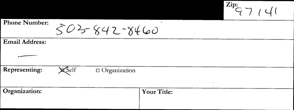
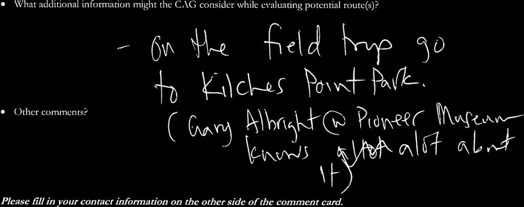
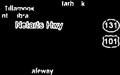
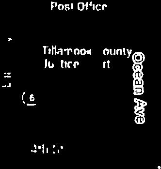
1 March 11, 2015 MEMORANDUM TO: FROM: Tillamook to Oceanside Transmission Line (TOTL) Siting Process Citizen Advisory Group (CAG) Debra Nudelman and Annie Kilburg, Kearns & West SUBJECT: Tillamook to Oceanside Transmission Line (TOTL) Siting Process Open House March 11, 2015 Public Comments Compilation Thank you for your participation and effort at the Tillamook to Oceanside Transmission Line (TOTL) Siting Process Open House held at the Oregon Department of Forestry, rd Street, Tillamook, OR, on Wednesday, March 11, 2015, from 6:00 8:30 PM. This memo includes a compilation of the public comments submitted, notes taken by the staff and a copy of the comment cards and any materials that the public submitted with their comments. David and Doris Mast (landowners): Provided materials on 3/11/15 and 3/13/15. (Note: Please see attached comment card and materials). David Mast (landowner): Provided materials. (Note: Please see attached comment card and materials). Alene Allen (citizen): o Other comments: I believe the new substation should be built. The line should be planned to disrupt no more than possible. I wouldn t want it close to my house, but how bad is that big a powerline really to health and livelihood? Anonymous: o Other comments: All for it Dave Hendrickson (representing self): o What input or feedback would you like to share with the TOTL Citizen Advisory Group (CAG) as they evaluate potential route(s) and provide recommendations to the Tillamook PUD? Why not go along Hwy 131 with existing line and do a major upgrade? There is a current right-of-way. o What additional information might the CAG consider while evaluating potential route(s)? On the field trip, go to Kilchis Point Park. (Gary Albright at Pioneer Museum knows a lot about it). TOTL / TOTL Open House Public Comments Compilation Page 1 of 5
2 Paul Levesque (CAG member): Provided materials. (Note: Please see attached comment card and materials). o Oregon Solutions to construct a contaminated soils cell along Front Street, 3.5 above flood level. Anonymous: o What input or feedback would you like to share with the TOTL Citizen Advisory Group (CAG) as they evaluate potential route(s) and provide recommendations to the Tillamook PUD? 118K near radio Station will disrupt AM station Minimize impact to AM Have RF engineer look at consequences Do diligence Ron Marolf (landowner): Provided materials. (Note: Please see attached comment card and materials). o I would rather have it in my field than my backyard. Gary Mahan (representing Ocean Highlands organization): o What input or feedback would you like to share with the TOTL Citizen Advisory Group (CAG) as they evaluate potential route(s) and provide recommendations to the Tillamook PUD? Has the option of overbuilding the existing route on Tone Road 131 for 115 KVA line to the new substation and connecting the route up to Cape Mears back along that route. o What additional information might the CAG consider while evaluating potential route(s)? Cost! Ease of permitting o Other comments? What RF vs. 115 KVA energy will effect KTIL AM passing close to transmission tower? Anonymous: o What input or feedback would you like to share with the TOTL Citizen Advisory Group (CAG) as they evaluate potential route(s) and provide recommendations to the Tillamook PUD? The route is already decided CAG is a legitimacy comm. Not an advisory group. o What additional information might the CAG consider while evaluating potential route(s)? Need! o Other comments? Wave energy will come if substation is built. Donnie Aufdermauer (landowner): o What input or feedback would you like to share with the TOTL Citizen Advisory Group (CAG) as they evaluate potential route(s) and provide recommendations to the Tillamook PUD? Tone Road route avoid Front Street and protect sloughs Gus Meyer (representing self and County Roads, Soil and Water): o What input or feedback would you like to share with the TOTL Citizen Advisory Group (CAG) as they evaluate potential route(s) and provide recommendations to the Tillamook PUD? What is the range of estimated costs for proposed TOTL routes? Who will finance/pay for the TOTL line? TOTL / TOTL Open House Public Comments Compilation Page 2 of 5
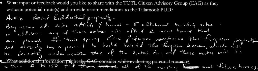
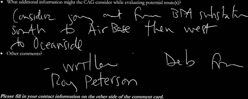
3 Transmission line to be underground through populated areas. Health and safety concerns; including emergency air support. o What additional information might the CAG consider while evaluating potential route(s)? Please take PUD Director Ray Sieler s August 2014 Ruralite letter on nuclear energy generation to heart. Place nuscales small nuclear generator at the current end of TOTL proposed site near Oceanside. Save costs, forest easements while reducing general public emotions on a notable scale. o Other comments? PUD has lost their LUBA appeal utilizing the Front Street route. This remains on their active proposed routes mapping. Eric Peterson (representing self and family, farm): o What input or feedback would you like to share with the TOTL Citizen Advisory Group (CAG) as they evaluate potential route(s) and provide recommendations to the Tillamook PUD? We don t want wave energy off Oceanside, Netarts, Cape Mears, etc. o What additional information might the CAG consider while evaluating potential route(s)? Don t touch our property!!! Period o Other comments? Keep transmission line out of my area completely, that includes my parents Roy and Claire Peterson s property!!! Michael Blair (representing self): o What input or feedback would you like to share with the TOTL Citizen Advisory Group (CAG) as they evaluate potential route(s) and provide recommendations to the Tillamook PUD? Avoid rural residential property. Bayocean Road route affects four homes and five additional building sites in addition. Any of their routes will affect two new homes that are planned for this spring. Eric Peterson purchased the Furguson property and already has a permit to build behind the Furguson home, which will be directly underneath one of the routes. Any of these routes will be within feet from all of the existing and future homes. Roy Peterson: o What additional information might the CAG consider while evaluating potential route(s)? Consider going out from BPA substation south to Air Base, then west to Oceanside. David Wells (representing self): o What input or feedback would you like to share with the TOTL Citizen Advisory Group (CAG) as they evaluate potential route(s) and provide recommendations to the Tillamook PUD? I would like to see a seismically (earthquake) stable route chosen. o What additional information might the CAG consider while evaluating potential route(s)? Seismically (earthquake) stable Able to direct power to Tillamook in case of an earthquake from Navy ship. Be able to route power to the grid from offshore wine or wave generating structures (long term concept). TOTL / TOTL Open House Public Comments Compilation Page 3 of 5
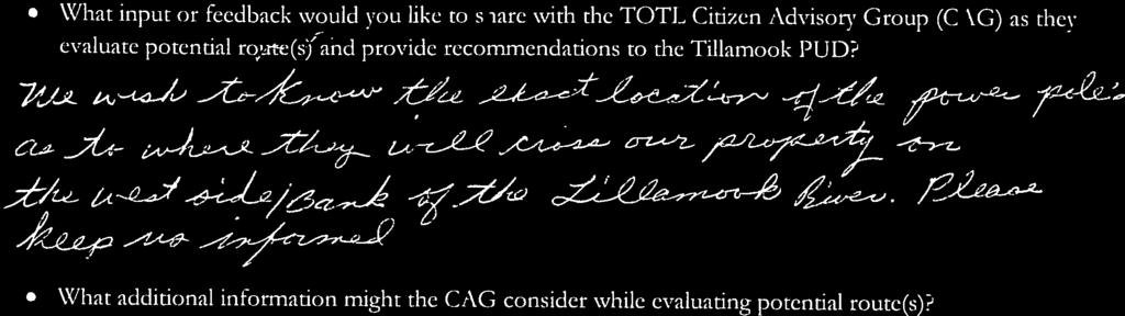
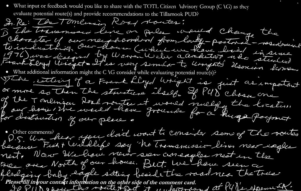
4 Don Caspell (property owner): Provided drawing on a map (Note: Please see attached comment card and map). o What input or feedback would you like to share with the TOTL Citizen Advisory Group (CAG) as they evaluate potential route(s) and provide recommendations to the Tillamook PUD? We wish to know the exact location of the power poles; as to where they will cross our property on the west side/bank of the Tillamook River. Please keep us informed. Roy and Claire Peterson (property owners): o What input or feedback would you like to share with the TOTL Citizen Advisory Group (CAG) as they evaluate potential route(s) and provide recommendations to the Tillamook PUD? In regard to the Tomlinson Road routes: The transmission line on poles would change the character of our neighborhood from lovely pastoral residential to industrial. Our house (which we have lived in since 1976) was designed by Warren Weber, an architect, who studied under Frank Lloyd Wright. It is very similar to Wrights Usonian homes. The settling of a Frank Lloyd Wright is just as important, or more so than the structure itself. If PUD chose one of the Tomlinson Road routes it would nullify the location of our home, we would have grounds for a huge payment for distribution of our place. o Other comments? P.S. We hear you don t want to consider some of the routes because Fish and Wildlife say no transmission lines near eagles nest. Now, we have never seen an eagles nest in the tree area north of our house. But, we have seen a fledgling baby eagle sitting beside the road near the trees. IF PUD chooses this route and puts it underground at PUD s expense, OK. Loretta and Eric Peterson (property owners): Provided materials (Note: Please see attached materials). o Handout provided: No transmission lines we need roads fixed! TOTL / TOTL Open House Public Comments Compilation Page 4 of 5
5 The following notes were taken by the staff, based on the public s comments and questions at the Open House on March 11, 2015: Comments at Table Four: Why can t you work on the wire hot? Can t you put out a temporary line to work hot? There aren t that many people in Netarts/Oceanside Can there be a walking path under the transmission line? Eagles nest on Hadley Road Eagles nest off Hwy 101, north of slough Infrastructure, improvement, existing at BPA substation and distribution along Hwy 101 Use Trask substation as take off Choose a route that is less intrusive 100 beck line (logging road) south In last five years, how many new meters in Oceanside? Why is Front Street still on the map after the LUBA decision? What load growth in city? Upgrade existing distribution along Hwy 131 and Bayocean and link near Oceanside - plus add a transformer at BPA substation still need new transmission line and substation Run DC instead of AC, does this reduce number of conductors? Comments at Table Six: Gus Meyer: o Has pacemaker and doctor says to stay away from transmission o Eight year limit on high voltage lines work in MN o Should build a nuclear station in Netarts RadioShack KTIL: o Hire RF engineer to determine if it is going to affect KTIL o Reduces likelihood of lawsuit o He has discussed this with the owner Troy: o Look into a way to shield the EMF? This memo respectfully submitted by Kearns & West. TOTL / TOTL Open House Public Comments Compilation Page 5 of 5
6
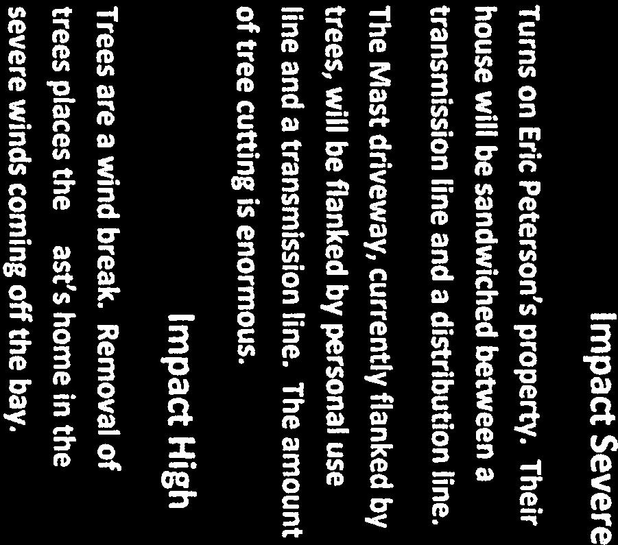
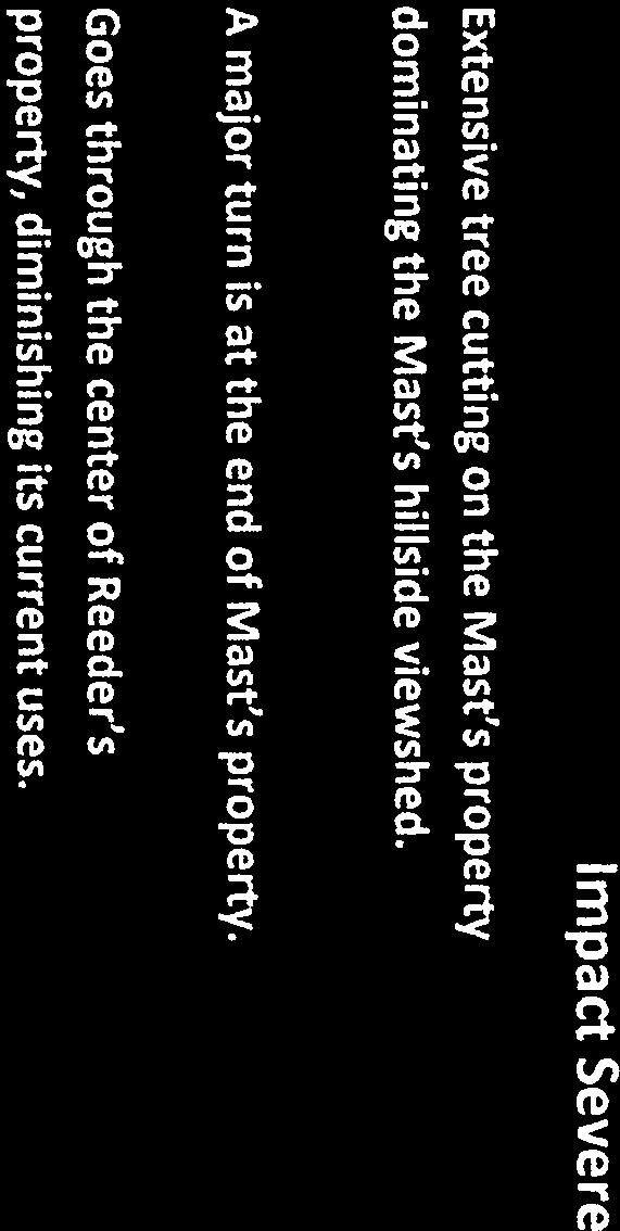
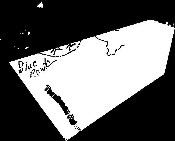
7 Route Evaluation Using the Proposed Criteria David & Doris Mast Modified Blue Route Orange Route MUST HAVE MAXIMIZE Is siteable (Can be Obtained) NO NO Tillamook County Land Use Ordinance Section Criterion (4) requires that The proposed use would not alter the character of the surrounding area in a manner which (sic) substantially limits, impairs or prevents the use of surrounding properties for the permitted uses listed in the underlying zone. Criterion (3) requires that The parcel is suitable for the proposed use considering its size, shape, location, topography, existence of improvements and natural features. Tillamook PUD Board of Directors voted to avoid going through property zoned Rural Residential 2 acres. Co-location within existing corridors NO NO Use of existing rights-of- way and pole locations NO NO AVOID OR MINIMIZE Number of landowners and properties affected 4 Landowners 4 Landowners 6 Lots 6 Lots Visual Impact Impact Severe Impact Severe (4) Closer to Mast house than blue route. Turns on Eric Peterson s property. Their More poles on Mast property than house will be sandwiched between a blue route. Extensive tree cutting on transmission line and a distribution line. the Mast property dominating the Mast hillside viewshed. Turns on Eric Peterson s property. Their house will be sandwiched between a transmission line and a distribution line. A major turn is at the end of Mast s property. The Mast driveway, currently flanked by trees, will be flanked by personal use line and a transmission line. The amount of tree cutting is enormous. Conflicts with existing land uses, structures, congestion Impact High Impact High (3) Trees, salmonberry and huckleberry bushes Trees are a wind break. Removal of will be lost. Trees are a wind break, removal trees places the Mast s home in the of trees puts R. Peterson property in the wind severe winds coming off the bay. The modified blue route is 50 closer to the Mast house than the previous blue route. (OVER)
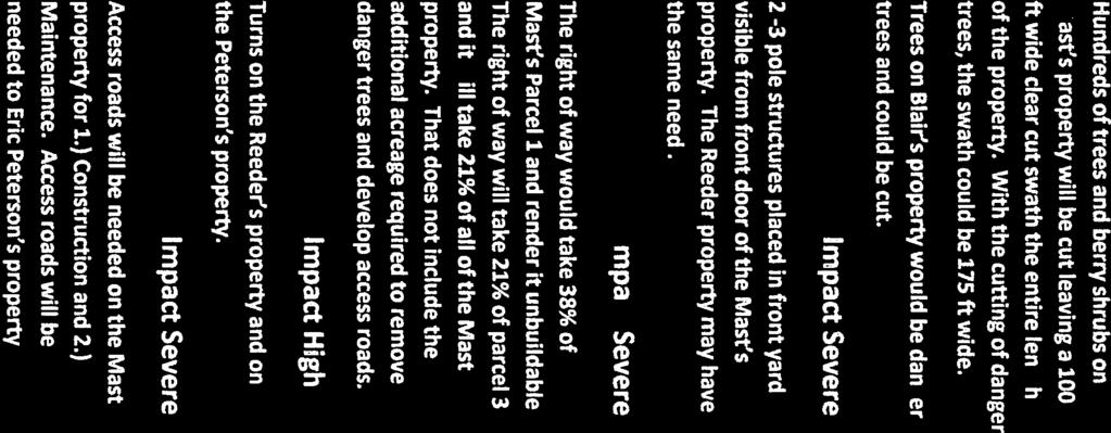
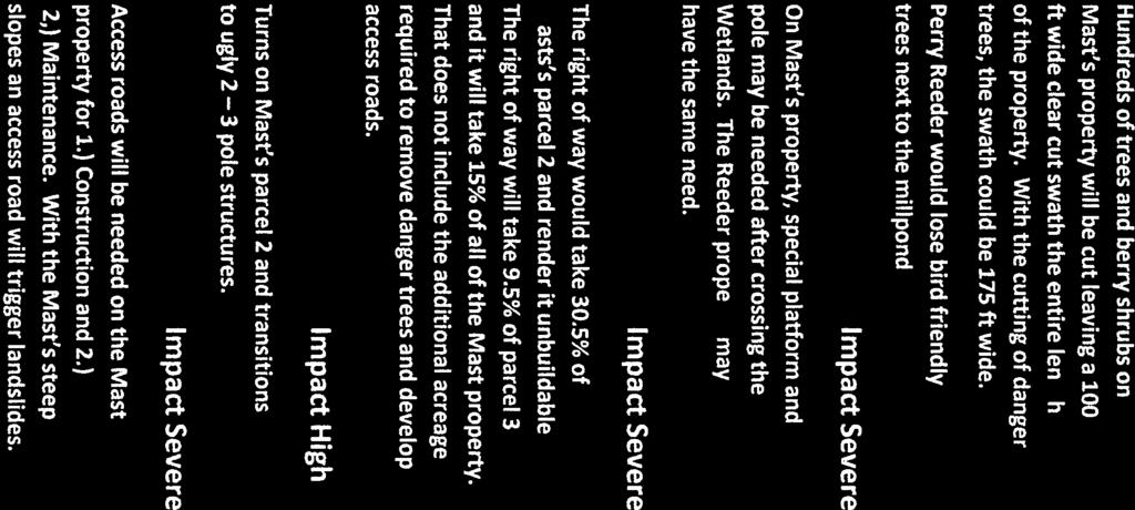
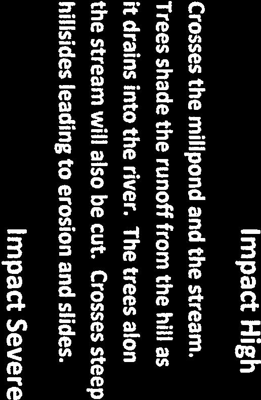
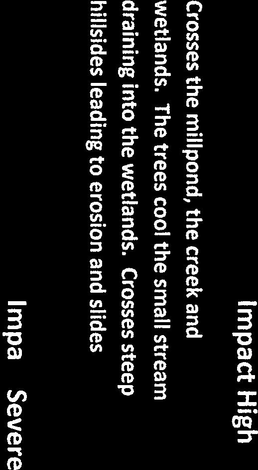
8 Environmental issues Impact High Impact High (3) Crosses the millpond, the creek and Crosses the millpond and the stream. wetlands. The trees cool the small stream Trees shade the runoff from the hill as draining into the wetlands. Crosses steep it drains into the river. The trees along hillsides leading to erosion and slides the stream will also be cut. Crosses steep Erosion potential at 3 places: 1. On the creek hillsides leading to erosion and slides. on parcel 3 2. below the house on parcel 3 3. the canyon slope on parcel 2. Effects on existing vegetation Impact Severe Impact Severe (4) Hundreds of trees and berry shrubs on Hundreds of trees and berry shrubs on Mast s property will be cut leaving a 100 Mast s property will be cut leaving a 100 ft wide clear cut swath the entire length ft wide clear cut swath the entire length of the property. With the cutting of danger of the property. With the cutting of danger trees, the swath could be 175 ft wide. trees, the swath could be 175 ft wide. Special Structures Trees on Blair s property would be danger trees and could be cut. Impact Severe 2-3 pole structures placed in front yard visible from front door of the Mast s property. Space Requirements Impact Severe Impact Severe (4) The right of way would take 30.5% of The right of way would take 38% of Mast s parcel 2, therefore the Masts can Mast s Parcel 1 and needs a pole at the no longer build a home on Parcel 2 which site of the new home because of the slopes, loses its value. therefore, the Mast s can no longer build a The right of way will take 13% of parcel 3. home on parcel 1 which then loses its value. It will take 18.5% of all of the Mast property. The right of way will take 21% of parcel 3 That does not include the additional acreage and it will take 21% of all of the Mast required to remove danger trees and develop property. That does not include the access roads. The modified blue route is additional acreage required to remove 30% longer through the Mast property than danger trees and develop access roads. the blue route. Angle Poles Impact High Impact High Turns right after Mast s parcel 2 and transitions to ugly 2 3 pole structures. Turns on the Reeder s property and on the Peterson s property. Need for Access Roads Impact Severe Impact Severe (3) Access roads will be needed on the Mast Access roads will be needed on the Mast property for 1.) Construction and 2.) property for 1.) Construction and 2.) 2,) Maintenance. With the Mast s steep Maintenance. Access roads will be slopes an access road will trigger landslides. needed to Eric Peterson s property.
9


10


11

12


13


14
15


16


17

18

19

20


21

22
23


24

25


26


27


28

29


30


31
32

33
34

35


36


37


38
39
40


41

42


43
44
45


46
47


48


49
Appendix L Technical Memorandum Aesthetics
 Technical Memorandum Aesthetics 1.0 AESTHETICS This section provides a discussion of the aesthetic resources in the vicinity of ARTIC. Aesthetics pertain to the elements that make a certain view pleasing
Fall 2014 Open House and Feedback Summary
 Fall 2014 Open House and Feedback Summary Overview 12/4/14 Puget Sound Energy (PSE) hosted an online open house from Nov. 3 to Nov. 21, 2014 and two in-person open houses on Nov. 12 and 13. At these open
Electric System Serving Pierce County Current system and future investments. Janet Olsen Steve Botts
 Electric System Serving Pierce County Current system and future investments Janet Olsen Steve Botts Project Manager Real Estate t / Rights-of-Way April 13, 2011 Presentation overview Information requested
Electric System Serving Pierce County Current system and future investments
 Electric System Serving Pierce County Current system and future investments Janet Olsen Project Manager Steve Botts Real Estate / Rights-of-Way April 13, 2011 Presentation overview Information requested
ROAD AND TRAIL PROJECT APPROVAL
 ROAD AND TRAIL PROJECT APPROVAL www.marincountyparks.org Marin County Parks, 3501 Civic Center Dr, Suite 260, San Rafael, CA 94903 DATE: July 12, 2017 PRESERVE: Gary Giacomini Open Space Preserve PROJECT:
Agenda Report. Spruce Street Outlet Drainage Improvements Tower Road Relief Sewer
 Agenda Report Subject: Prepared By: Spruce Street Outlet Drainage Improvements Tower Road Relief Sewer Steven M. Saunders, Director of Public Works/Village Engineer Date: August 12, 2012 On March 8, 2012
Chuckanut Ridge Fairhaven Highlands EIS Scoping Concerns
 Chuckanut Ridge Fairhaven Highlands EIS Scoping Concerns Coalition of Southside Neighborhoods CSN Comments for Fairhaven Highlands EIS Scope Hearing, Jan 16, 2008 1 Chuckanut Ridge Hilly Terrain: Potential
EAST DON TRAIL ENVIRONMENTAL ASSESSMENT. Community Liaison Committee Meeting #3 July 15, :30 to 8:30 pm Flemingdon Park Library
 EAST DON TRAIL ENVIRONMENTAL ASSESSMENT Community Liaison Committee Meeting #3 July 15, 2013 6:30 to 8:30 pm Flemingdon Park Library Agenda 1. Welcome 2. Housekeeping and Updates a) Housekeeping b) CLC
Morrison County Board of Adjustment. Minutes. July 7, 2015
 Morrison County Board of Adjustment Minutes July 7, 2015 Chairman Charlie Gunderson called the meeting of the Morrison County Board of Adjustment to order at 7:00 P.M. Members Present: Charlie Gunderson,
Logo Department Name Agency Organization Organization Address Information 5700 North Sabino Canyon Road
 Logo Department Name Agency Organization Organization Address Information United States Forest Coronado National Forest 5700 North Sabino Canyon Road Department of Service Santa Catalina Ranger District
With the first portion of this process complete, we anticipate the general timeline for the remainder of the process to be:
 THE CITY OF FIRE RESCUE E D M O N T O N FIRE RESCUE SERVICES 10351 96 Street Edmonton, Alberta T5H 2H5 April 19, 2013 Dear Rossdale residents: As many of you know, Fire Rescue Services is currently in
Thornton Water Project. Larimer County Route Study and Project Update September 12, 2017
 Thornton Water Project Larimer County Route Study and Project Update September 12, 2017 Purpose of Meeting Provide information on the Thornton Water Project Present the results of the pipeline routing
Livonia Joint Planning Board January 25, 2016
 1 Livonia Joint Planning Board PRESENT:: Chair R. Bennett, R. Haak, D. Richards, C. Casaceli, J. Palmer, D. Simpson, J. Sparling, Attorney J. Campbell, Code Enforcement Officer-A. Backus, Recording Secretary-B.
Motion by Michel to approve the minutes as presented, second by Rynish, motion carried 5-0.
 SUAMICO BOARD OF APPEALS MINUTES 12781 VELP AVENUE Tuesday, August 29, 2017 7: 00 P. M. 1) CALL MEETING TO ORDER Board members present by roll call: Sue Last aye, Dan Schrader aye, Bart Rynish aye, Sharon
Medina Park Commission Meeting Minutes August 26, 2014 Medina City Hall Page 1 of 6
 1 of 6 The Park Commission of Medina, Minnesota met in special session on at 6:00 p.m. at. Park Commission Chair Ann Thies presided. 1) Call to Order Commissioners Present: Commissioners Absent: Also Present:
Mountain Valley Pipeline, LLC Mountain Valley Pipeline Project Docket No. CP
 16. Prior to construction, Mountain Valley shall file with the Secretary, for review and approval by the Director of OEP, a segment-specific construction and operation access plan for the area between
MESA COUNTY DEPARTMENT OF PUBLIC WORKS Administration - Building - Engineering Road and Bridge Traffic - Planning - Solid Waste Management
 MESA COUNTY DEPARTMENT OF PUBLIC WORKS Administration - Building - Engineering Road and Bridge Traffic - Planning - Solid Waste Management 200 S. Spruce St. P.O. Box 20,000 Grand Junction, Colorado 81502-5022
PLANNING BOARD MEETING Monday, November 13, :00 PM Council Chambers, City Hall. MINUTES Approved 12/11/2017
 PLANNING BOARD MEETING Monday, November 13, 2017 7:00 PM Council Chambers, City Hall MINUTES Approved 12/11/2017 I. Roll Call Present: Marilyn Harris, Bruce Kolenda, Marlene Jordan, Richard Wahrlich, David
Watch Outs! Will Your Home Survive? The Homeowner s Watch Outs! will allow you to evaluate your situation and set a plan to correct any concerns.
 Homeowner s Watch Outs! Will Your Home Survive? The Homeowner s Watch Outs! will allow you to evaluate your situation and set a plan to correct any concerns. Each year, hundreds of homes are destroyed
Park Updates 1. Cavalero 2. Lundeen 3. Frontier Heights Citizen Advisory Committee
 Page 1 of 10 PARK BOARD AGENDA Community Center 1808 Main Street, Lake Stevens Monday, April 11, 2016 CALL TO ORDER: 6:00 pm ROLL CALL: GUEST BUSINESS: ACTION ITEMS: A. B. C. Approval of February 8, 2016
Decision Memo for Desolation Trail: Mill D to Desolation Lake Trail Relocation
 for Salt Lake County, Utah Uinta-Wasatch-Cache National Forest Salt Lake Ranger District 1. Background The present location of the Desolation Trail (#1159) between Mill D and Desolation Lake follows old
Staff Report Sign Design
 Staff Report Sign Design July 29, 2014 Planning & Zoning Commission Meeting Report date July 23, 2014 Project type Sign Design Legal description Section 2, Township 5, Range 82 Lots 3&4, S1/2NW1/4, SW1/4
Sudbury to Hudson Transmission Reliability Project
 An independent assessment of routing options Sudbury to Hudson Transmission Reliability Project and use of a rail-banked corridor for this purpose Prepared by: NorthEast Logistics Systems, LLC August 29,
METROPOLITAN COUNCIL 390 North Robert Street, St. Paul, MN Phone (651) TDD (651)
 TDD (651)") DATE: March 27, 2012 METROPOLITAN COUNCIL 390 North Robert Street, St. Paul, MN 55101 Phone (651) 602-1000 TDD (651) 291-0904 TO: Metropolitan Parks and Open Space Commission FROM: Arne Stefferud, Planning
DATE: March 27, 2012 METROPOLITAN COUNCIL 390 North Robert Street, St. Paul, MN 55101 Phone (651) 602-1000 TDD (651) 291-0904 TO: Metropolitan Parks and Open Space Commission FROM: Arne Stefferud, Planning
JACKSON TOWNSHIP BOARD OF ZONING APPEALS Thursday September 27, 2012
 JACKSON TOWNSHIP BOARD OF ZONING APPEALS Thursday September 27, 2012 Members present: Edward McDonnell Ted Deremer Leon Vitale Phillip Kirkbride Gary Zillich Daniel Creighton-Alternate 5:30 pm Appeal #2233
Roberts Bank Terminal 2 Project
 SEPTEMBER 2013 Roberts Bank Terminal 2 Project The Roberts Bank Terminal 2 Project is a proposed new three-berth container terminal in Delta, B.C. that would provide 2.4 million TEUs (twenty-foot equivalent
AGAWAM CONSERVATION COMMISSION April 26, 2018
 MEMBERS PRESENT: Henry A. Kozloski, Chairman Sheryl Becker S. Page Fallon Frank Meagher MEMBERS ABSENT: Magda Galiatsos Jill Messick ALSO PRESENT: Pamela R. Kerr AGAWAM CONSERVATION COMMISSION Mr. Kozloski
China Creek North Park Upgrades and Glen Pump Station. Park Board Committee Meeting Monday, July 10, 2017
 China Creek North Park Upgrades and Glen Pump Station Park Board Committee Meeting Monday, July 10, 2017 Purpose The purpose of this presentation is to: Share the results of the public engagement processes;
Trail # NW Tuesday, June DESIGN. Provide an Review the Provide an. Project Goals: System system. wayfinding
 I. Welcome / Introductions Bethany Creek Trail #2 Segment 3 Neighborhood Meeting #1 Bethany Presbyterian Church 15505 NW Springville Road, Portland, OR 97229 Tuesday, June 26, 2018 @ 6:00PM Meeting Minutes
OWNED LAND ACTIVITIES REPORT February 2012
 OWNED LAND ACTIVITIES REPORT February 2012 BULL RUN MOUNTAINS NATURAL AREA PRESERVE A tremendous number of projects are underway on the Preserve. Currently VOF is working with the Smithsonian Conservation
Representative (s) in Attendance
 in Attendance") Meeting Summary Advisory Group Meeting #6 February 2, 2012 5:30 p.m. to 8:30 p.m. Baymont Inn and Suites, Kirkland, WA Organization Aerojet City of Kirkland, Public Works City of Redmond, Planning Evergreen
Meeting Summary Advisory Group Meeting #6 February 2, 2012 5:30 p.m. to 8:30 p.m. Baymont Inn and Suites, Kirkland, WA Organization Aerojet City of Kirkland, Public Works City of Redmond, Planning Evergreen
ZC08-06 Rezone request of Charles Leon Saltz from R3 High Density Single Family Residential to B-4 Business and Professional Office
 The Planning & Zoning Commission of the City of Fairhope met Monday, August 4, 2008, at 5:00 PM at the City Administration Building, 161 N. Section Street in the Council Chambers. Present: Jean Wilson,
CRAZY HORSE TRAIL GUIDE
 CRAZY HORSE TRAIL GUIDE Abridged Version: July 2016 This is a short form of our interpretive trail guide for the Crazy Horse Trail. The full version of the guide has a more detailed description of the
Memorandum / Letter of Intent
 VERONA WAUKESHA KENOSHA APPLETON WESTON Memorandum / Letter of Intent To: Adam Sayre, Director of Planning & Development, City of Verona From: Kevin Yeska, JSD Professional Services, Inc. www.jsdinc.com
Stage 2 ION: Light Rail Transit (LRT) from Kitchener to Cambridge
 from Kitchener to Cambridge") Stage 2 ION: Light Rail Transit (LRT) from Kitchener to Cambridge Public Consultation Centre (PCC) No. 3 Please Sign-in Cambridge City Hall November 21, 2017 2:00 to 8:00pm Preston Memorial Auditorium
Stage 2 ION: Light Rail Transit (LRT) from Kitchener to Cambridge Public Consultation Centre (PCC) No. 3 Please Sign-in Cambridge City Hall November 21, 2017 2:00 to 8:00pm Preston Memorial Auditorium
Longmont to Boulder Regional Trail Jay Road Connection DRAFT FINAL REPORT
 Longmont to Boulder Regional Trail Jay Road Connection DRAFT FINAL REPORT December 2018 Project Summary Boulder County, Colorado, in partnership with the City of Boulder, is evaluating options for multi-use
C. APPROACH FOR IDENTIFYING THE BEST ROUTES FOR THE NEEDED TRANSMISSION SYSTEM IMPROVEMENTS
 C. APPROACH FOR IDENTIFYING THE BEST ROUTES FOR THE NEEDED TRANSMISSION SYSTEM IMPROVEMENTS CL&P s approach for identifying the best routes for the needed transmission system improvements included a determination
Trail Assessment Report
 Trail Assessment Report Trail Options for the Bear Creek Canyon located in Pikes Peak Ranger District, Pike National Forest and on Colorado Springs Utility Lands Due to the presence of a unique species
TOWN OF WAKEFIELD, NEW HAMPSHIRE PLANNING BOARD
 TOWN OF WAKEFIELD, NEW HAMPSHIRE PLANNING BOARD 2 High Street Sanbornville, New Hampshire 03872 Telephone: (603)522-6205 Fax: (603)522-2295 MINUTES OF THE PUBLIC HEARING November 15, 2012 Final Copy MEMBERS
Conservation of Critical Environmental Resources in Chatham Park
 Conservation of Critical Environmental Resources in Chatham Park Elaine Chiosso, Haw Riverkeeper Haw River Assembly Haw River As Seen From Chatham Park "Spreading southwestward from the banks of the Haw
MUNICIPALITY OF ANCHORAGE
 DATE: June 3, 2009 MUNICIPALITY OF ANCHORAGE PARKS & RECREATION DEPARTMENT MEMORANDUM PRC #09-35 TO: FROM: SUBJECT: Parks and Recreation Commission Tom Korosei, Park Planner Proposed Land Exchange for
URBAN DESIGN REPORT. Proposed Residential Development, Old Church Road, Caledon East
 Proposed Residential Development, Old Church Road, Caledon East TABLE CONTENTS: 1.0 DEVELOPMENT 1.1 Introduction-Analysis of Guiding Principles and Documents 1.2 Community Design and Architectural Design
Citrus Heights Creek Corridor Trail Project. Trail Advisory Group Meeting #3 July 8, 2013
 Citrus Heights Creek Corridor Trail Project Trail Advisory Group Meeting #3 July 8, 2013 Agenda Introductions Recap: Community Workshop, Survey Findings, and TAG Field Trip Community Concern Discussion:
Blueways: Rivers, lakes, or streams with public access for recreation that includes fishing, nature observation, and opportunities for boating.
 Parks, Open Space and Trails PRINCE WILLIAM COUNTY 2008 COMPREHENSIVE PLAN TRAILS PLAN CONTENTS The components of the trails plan are: Intent Definitions Goals, Policies, and Action Strategies Trails Map
Section 4(f) and Section 6(f) Technical Analysis
 and Section 6(f) Technical Analysis") WESTSIDE SUBWAY EXTENSION PROJECT Contract No. PS-4350-2000 Section 4(f) and Section 6(f) Technical Analysis Prepared for: Prepared by: WSP USA 851 SW Sixth Avenue, Suite 1600 Portland, Oregon 97204 FEBRUARY
WESTSIDE SUBWAY EXTENSION PROJECT Contract No. PS-4350-2000 Section 4(f) and Section 6(f) Technical Analysis Prepared for: Prepared by: WSP USA 851 SW Sixth Avenue, Suite 1600 Portland, Oregon 97204 FEBRUARY
David Johnson. Tom, Attached please find the final scoping letter and figures for your review. David
 David Johnson From: Sent: To: Cc: Subject: Attachments: David Johnson Tuesday, April 12, 2011 4:33 PM Thomas Malecek Dave Dyer; Jason Marks (jmarks@segroup.com) VWC Scoping Letter
DATE: 23 March, 2011 TO: Communities FROM: BlazeSports America. RE: Accessible Trails Checklist 1
 M E M O R A N D U M DATE: 23 March, 2011 TO: Communities FROM: BlazeSports America RE: Accessible Trails Checklist 1 The purpose of the Accessible Trails Checklist (below) is to help the community review
MASTER PLAN EXECUTIVE SUMMARY
 Biscuit Run State Park Scottsville Road (State Route 20) Charlottesville, VA 22902 Biscuit Run State Park MASTER PLAN EXECUTIVE SUMMARY Department of Conservation and Recreation Division of Planning and
White Mountain National Forest Saco Ranger District
 United States Department of Agriculture Forest Service White Mountain National Forest Saco Ranger District 33 Kancamagus Highway Conway, NH 03818 Comm: (603) 447-5448 TTY: (603) 447-3121 File Code: 1950
Citrus Heights Creek Corridor Trail Project Trail Advisory Group Field Trip #2 September 11, :00 11:00 am Trellis Hall, Citrus Heights
 September 11, 2013 9:00 11:00 am Trellis Hall, Citrus Heights Project Overview The City of Citrus Heights is studying the feasibility of establishing a multi use trail system within the City s 26 miles
VILLAGE OF ARDSLEY ZONING BOARD OF APPEALS REGULAR MEETING WEDNESDAY, FEBRUARY 25, 2015
 VILLAGE OF ARDSLEY ZONING BOARD OF APPEALS REGULAR MEETING WEDNESDAY, FEBRUARY 25, 2015 PRESENT: Patricia Hoffman, Chairman Michael Wiskind Jacob Amir Ellen Slipp Mort David Call to Order Ms. Hoffman called
Meeting Notes Public Open House
 Meeting Notes Public Open House, 5:30-8:00 pm Fairbanks Pipeline Training Center, 3605 Cartwright Court, Fairbanks, Alaska= Agenda: Open House: 30 minutes Presentation: 45 minutes Question and Answers:
TRANSMITTAL. Please contact me with any questions. 7 Spruce Road, Freeport, ME T: (207)
") BAKER DESIGN CONSULTANTS Civil, Marine and Structural Engineering To: Alex Jaegerman FAICP Director of Planning & Development Town of Yarmouth 200 Main Street PO Box 907 Yarmouth, ME 04096 From: Barney
BAKER DESIGN CONSULTANTS Civil, Marine and Structural Engineering To: Alex Jaegerman FAICP Director of Planning & Development Town of Yarmouth 200 Main Street PO Box 907 Yarmouth, ME 04096 From: Barney
Public Notice ISSUED: December 10, 2018 EXPIRES: January 9, 2019
 APPLICANT: REFER TO: St. Louis and Lake Counties Regional Rail Authority 2018-01942-ARC Public Notice ISSUED: December 10, 2018 EXPIRES: January 9, 2019 SECTION:404 - Clean Water Act 1. APPLICATION FOR
Frequently Asked Questions and Answers Bowman Field Airport Area Safety Program
 Frequently Asked Questions and Answers Bowman Field Airport Area Safety Program 1. What is the proposed Bowman Field Airport Area Safety Program? The proposed Bowman Field Airport Area Safety Program has
Auburn Trail/Ontario Pathways Trail Connector Feasibility Study Project Advisory Group Meeting August 25, 2011 Farmington Town Hall Approved Minutes
 Auburn Trail/Ontario Pathways Trail Connector Feasibility Study Project Advisory Group Meeting August 25, 2011 Farmington Town Hall Approved Minutes Committee Members Attending: Ronald L. Brand, Director
Flying Cloud Airport (FCM) Zoning Process: Informing a Mn/DOT Path Forward
 Zoning Process: Informing a Mn/DOT Path Forward") : Informing a Mn/DOT Path Forward A Review of the Flying Cloud Airport (FCM) Joint Airport Zoning Board (JAZB) Process and the Draft Airport Zoning Ordinance B A RPZ RPZ A B C Zone Chad E. Leqve Director
: Informing a Mn/DOT Path Forward A Review of the Flying Cloud Airport (FCM) Joint Airport Zoning Board (JAZB) Process and the Draft Airport Zoning Ordinance B A RPZ RPZ A B C Zone Chad E. Leqve Director
STAFF REPORT. Airport Land Use Consistency Determination Betteravia Plaza. MEETING DATE: January 21, 2016 AGENDA ITEM: 8D
 STAFF REPORT SUBJECT: Airport Land Use Consistency Determination Betteravia Plaza MEETING DATE: AGENDA ITEM: 8D STAFF CONTACT: Andrew Orfila RECOMMENDATION: Adopt findings for the Betteravia Plaza project
USDA Forest Service Deschutes National Forest DECISION MEMO. Round Lake Christian Camp Master Plan for Reconstruction and New Facilities
 USDA Forest Service Deschutes National Forest DECISION MEMO Round Lake Christian Camp Master Plan for Reconstruction and New Facilities Jefferson County, Oregon T. 13 S., R. 8 E., Section 16, W.M. Background:
Blanco Creek Ranch Acres, Uvalde County, Texas
 Blanco Creek Ranch 1208.30 Acres, Uvalde County, Texas James King, Agent Office 432 426.2024 Cell 432 386.2821 James@KingLandWater.com Blanco Creek Ranch 1208.30 acres Uvalde County, Texas James King,
1803 West Hwy 160 Monte Vista, CO (719) TTY (719)
 TTY (719)") USDA Forest Service Rio Grande National Forest http://www.fs.fed.us/r2/riogrande 1803 West Hwy 160 Monte Vista, CO 81144 (719)852-5941 TTY (719)852-6271 USDI Bureau of Land Management San Luis Valley Center
USDA Forest Service Rio Grande National Forest http://www.fs.fed.us/r2/riogrande 1803 West Hwy 160 Monte Vista, CO 81144 (719)852-5941 TTY (719)852-6271 USDI Bureau of Land Management San Luis Valley Center
Northeast Quadrant Distinctive Features
 NORTHEAST QUADRANT Northeast Quadrant Distinctive Features LAND USE The Northeast Quadrant includes all the area within the planning area that is east of Interstate 5 and to the north of State Route 44.
Open Space Index. Town of Philipstown. Adopted January 8, Submitted by: Philipstown Conservation Advisory Committee
 Open Space Index Town of Philipstown Adopted January 8, 2009 Submitted by: Philipstown Conservation Advisory Committee Acting Chair Eric Lind Mark Galezo Andy Galler Lew Kingsley Mike Leonard MJ Martin
Preliminary Site Evaluation
 Preliminary Site Evaluation 100 Acre Site, US 72 Piperton, Tennessee Power Distributor: Chickasaw Electric Cooperative August 2010 SITE DATA SHEET PIPERTON US 72 SITE (100 ACRES): LOCATION & GENERAL DESCRIPTION
UAV Flight Services Company. What We Do. What Sets us Apart
 UAV Flight Services Company A dedicated team of aviators, technologists, and engineers. What We Do UAV flight services for data collection, mapping, and inspection What Sets us Apart Extensive field experience,
Section 61 Recreational Vehicle Park / Campground (Bylaw No. 2012/10)
") Part 7 General Regulations Section 61 Recreational Vehicle Park / Campground (Bylaw No. 2012/10) 61.1 A comprehensive site plan shall be provided to the satisfaction of the Development Authority that shows
Part 7 General Regulations Section 61 Recreational Vehicle Park / Campground (Bylaw No. 2012/10) 61.1 A comprehensive site plan shall be provided to the satisfaction of the Development Authority that shows
Draft Concept Alternatives Analysis for the Inaugural Airport Program September 2005
 Draft Concept Alternatives Analysis for the Inaugural Airport Program September 2005 Section 3 - Refinement of the Ultimate Airfield Concept Using the Base Concept identified in Section 2, IDOT re-examined
INTRODUCTION. Mailing address: Burke County Community Development Attn: Tim Johnson P. O. Box 219 Morganton, NC
 REQUEST FOR QUALIFICATIONS: PROFESSIONAL, EXPERIENCED TRAIL BUILDERS FOR THE CONSTRUCTION OF THE FONTA FLORA STATE TRAIL LAKE JAMES SECTION BURKE COUNTY COMMUNITY DEVELOPMENT INTRODUCTION Burke County
Port Everglades Master/Vision Plan Update
 Port Everglades Master/Vision Plan Update Environmental Stakeholder Meeting June 15, 2009 Discussion to Focus On: Updating the 2006 Port Everglades Master Plan Issues dealing with the Turning Notch Potential
Dubuque County Zoning Board of Adjustment Minutes of May 1, 2018 Chairperson Ron Koppes called the meeting to order at 7 p.m.
 Dubuque County Zoning Board of Adjustment Minutes of May 1, 2018 Chairperson Ron Koppes called the meeting to order at 7 p.m. A. ROLL CALL: Members Present: Ron Koppes, Darlene Burds, Thomas Griep, Pat
LAS VARAS RANCH CA COASTAL TRAIL PROPOSED ALIGNMENT
 LAS VARAS RANCH CA COASTAL TRAIL PROPOSED ALIGNMENT Santa Barbara Trails Council * Prepared by Ray Ford February 1,2012 The following notes accompany the Santa Barbara Trails Council map for the Las Varas
DEPARTMENT OF PLANNING JEFFERSON PARISH, LOUISIANA
 DEPARTMENT OF PLANNING JEFFERSON PARISH, LOUISIANA DESIGN REVIEW REPORT : CPZ-3-5 ADVERTISING DATES: 03/25/5 04/0/5 04/08/5 : 2425 PUBLIC HEARING: 04/6/5 S: HEARING: 05/3/5 : Ricky J. Templet Chris Roberts,
17: Good Design - Tombs Site
 Rural Design Workbook: 17: Good Design - Tombs Site Site Introduction: The Tombs/Sullivan/Horton site is located within the Town of Campbell and is a combination of three properties totaling 356 acres:
Stage 2 - November 2017 Survey and Map Comments (verbatim)
") Stage 2 - November 2017 Survey and Map Comments (verbatim) Identifying information removed to meet Freedom of Information and Protection of Privacy Act (FOIP Act). Comments are recorded exactly as they
Stage 2 - November 2017 Survey and Map Comments (verbatim) Identifying information removed to meet Freedom of Information and Protection of Privacy Act (FOIP Act). Comments are recorded exactly as they
Rule Governing the Designation and Establishment of All-Terrain Vehicle Use Trails on State Land
 Rule Governing the Designation and Establishment of All-Terrain Vehicle Use Trails on State Land 1.0 Authority 1.1 This rule is promulgated pursuant to 23 V.S.A. 3506. Section 3506 (b)(4) states that an
 comment@boardmantohemingway.com From: Sent: To: Subject: Attachments: Bill Thursday, March 12, 2015 9:32 PM comment@boardmantohemingway.com B2H Comments B to H Response.doc Hello, I am
Report on Installation of Wayside Horns at Railroad Crossings and Railroad Trench System
 City Council Agenda November 4, 2014 Mayor and Council Agenda Item No. B.01 Reviewed by City Mgr s office: /KLM Memo to: From: Manteca City Council Karen L. McLaughlin, City Manager Date: October 28, 2014
BARRE TOWN PLANNING COMMISSION MINUTES
 BARRE TOWN PLANNING COMMISSION MINUTES The Town of Barre held their regular meeting on Wednesday, beginning at 7:00 p.m. at the Municipal Building, Lower Websterville. Members Present: Cedric Sanborn John
2. STAKEHOLDER FEEDBACK // What We Heard
 1. QUARRY ROAD TRAIL // Welcome to the Information Session PROJECT DESCRIPTION WHY WE ARE HERE Quarry Road Trail is a popular commuter trail and recreational area for Calgarians. 1. To report citizen feedback
Town of Oakfield Agricultural and Farmland Protection Plan
 SECTION III COMMUNITY OVERVIEW A. Regional Setting / Location The Town of Oakfield is located in the northwestern portion of Genesee County. Located west of New York's Finger Lakes, the Town is uniquely
Priscilla Davenport, Saluda District
 AT A MEETING OF THE MIDDLESEX COUNTY PLANNING COMMISSION HELD ON THURSDAY, NOVEMBER 13, 2003, IN THE PUBLIC MEETING ROOM OF THE COOK S CORNER OFFICE COMPLEX, COOK S CORNER, VIRGINIA. Present: Absent: John
APPROVED 10 LOT TENTATIVE TRACT MAP - OCEAN VIEWS
 Rare Development Opportunity in the Olde Carlsbad Neighborhood Ocean Views from Some Lots Lot Sizes 9,500-15,527 SF Area of New Home Prices From $1,000,000-$1,500,000 SUBMIT BEST OFFER - OFFERS DUE DECEMBER
APPENDIX 3-I-B. Alternative Route Assessment Around Provincial Parks and Conservation Reserves
 EAST-WEST TIE TRANSMISSION PROJECT ENVIRONMENTAL ASSESSMENT REPORT APPENDIX 3-I-B Alternative Route Assessment Around Provincial Parks and Conservation Reserves Report No. 1536607/2000/2018 TABLE OF CONTENTS
AGENDA REGULAR PARKS COMMISSION MEETING May 26, :15 A.M Monticello Public Works Office
 Park Commission Agenda: 05/26/2016 AGENDA REGULAR PARKS COMMISSION MEETING May 26, 2016 9:15 A.M Monticello Public Works Office To enhance community pride through developing and maintaining city parks
LONG TERM (OPERATION) IMPACTS AND POTENTIAL MITIGATION
 IMPACTS AND POTENTIAL MITIGATION") 3.6 This chapter provides a project-level analysis of potential impacts to recreation sites in the study area including parks, natural areas, open spaces, trails, and playfields, as well as amenities such
3.6 This chapter provides a project-level analysis of potential impacts to recreation sites in the study area including parks, natural areas, open spaces, trails, and playfields, as well as amenities such
PROPOSED PARK ALTERNATIVES
 8 Chimne y Rock State Park M a ster Pl an 2011 PROPOSED PARK ALTERNATIVES Introduction Three different park development concepts were prepared and presented to the citizens of North Carolina through a
Northern Rail Extension, Phase One
 General Project and Funding 1. Where does Phase One start? The rail line for Phase One begins roughly at the northern boundary of the former Bradbury property, but also includes work along Tom Bear Trail
National Wilderness Steering Committee
 National Wilderness Steering Committee Guidance White Paper Number 1 Issue: Cultural Resources and Wilderness Date: November 30, 2002 Introduction to the Issue Two of the purposes of the National Wilderness
Welcome KROSNO CREEK DIVERSION PROJECT CLASS ENVIRONMENTAL ASSESSMENT
 Welcome KROSNO CREEK DIVERSION PROJECT PUBLIC INFORMATION CENTRE # 1 Tonight s Presentation Study Overview Background Existing Conditions Alternative Solutions Preliminary Preferred Solution Next Steps
ARTICLE 34 AIRPORT HEIGHT COMBINING ZONE (AH) (Amended by Ordinance #295 Effective June 26, 2009)
 (Amended by Ordinance #295 Effective June 26, 2009)") ARTICLE 34 AIRPORT HEIGHT COMBINING ZONE (AH) (Amended by Ordinance #295 Effective June 26, 2009) Section 34.10 - Purpose and Intent The purpose of the Airport Height Combining Zone (AH) is to protect
ARTICLE 34 AIRPORT HEIGHT COMBINING ZONE (AH) (Amended by Ordinance #295 Effective June 26, 2009) Section 34.10 - Purpose and Intent The purpose of the Airport Height Combining Zone (AH) is to protect
Mason County Planning & Zoning Department 102 E. FIFTH STREET SCOTTVILLE, MICHIGAN (231) FAX (231)
 FAX (231)") Mason County Planning & Zoning Department E. FIFTH STREET SCOTTVILLE, MICHIGAN (1) - FAX (1) - 1 1 1 1 1 0 1 0 1 0 1 November, 0 Minutes of the Mason County Planning Commission meeting held at E. Fifth
Mason County Planning & Zoning Department E. FIFTH STREET SCOTTVILLE, MICHIGAN (1) - FAX (1) - 1 1 1 1 1 0 1 0 1 0 1 November, 0 Minutes of the Mason County Planning Commission meeting held at E. Fifth
Seek the Board s approval for the Donald Place kerb and channel renewal to progress to final design, tender and construction; and
 3. DONALD PLACE - KERB AND CHANNEL RENEWAL General Manager responsible: General Manager City Environment Officer responsible: Transport and City Streets Manager Author: Michelle Flanagan, Streets Capital
The Chu property is a 6.57 acre parcel located in the Town of Superior on the west side of McCaslin Boulevard. In 2014, the Town of Superior acquired
 1 The Chu property is a 6.57 acre parcel located in the Town of Superior on the west side of McCaslin Boulevard. In 2014, the Town of Superior acquired the Chu property for open space with a contribution
DRAFT WHITEWATER TOWNSHIP PLANNING COMMISSION MINUTES OF DECEMBER 7, 2011 REGULAR MEETING
 DRAFT WHITEWATER TOWNSHIP PLANNING COMMISSION MINUTES OF DECEMBER 7, 2011 REGULAR MEETING Call to Order by Zakrajsek at 7: pm Roll Call: Boyd, Zakrajsek, Miller, Courtade, Mangus, Recording Secretary-MacLean,
MUNICIPALITY OF ANCHORAGE
 MUNICIPALITY OF ANCHORAGE ANCHORAGE PARKS & RECREATION Memorandum PRC 08-56 DATE: 5 August 2008 TO: FROM: SUBJECT: Parks & Recreation Commission Holly Spoth-Torres, Park Planner PRC 08-56 Far North Bicentennial
Edward Hemminger read the legal notice for #ZB that was published in the Daily Messenger on July 18, 2011 re questing an area variance.
 TOWN OF FARMINGTON ZONING BOARD OF APPEALS MEETING MINUTES APPROVED MINUTES The following minutes are a written summary of the main points that were made and the actions taken at the Town of Farmington
Briarhill Neighborhood Polecat Priority List. Exhibit D-4
 Briarhill Neighborhood Polecat Priority List Exhibit D-4 March 11, 2013 The following list of trail head issues and design elements was developed by Briarhill 2/3 neighborhood residents living near the
VI. ALTERNATIVES TO THE MASTER PLAN C. RENOVATED EAST BUILDING ALTERNATIVE
 VI. ALTERNATIVES TO THE MASTER PLAN C. RENOVATED EAST BUILDING ALTERNATIVE INTRODUCTION The Renovated East Building Alternative would include the continued use of the renovated West Building and the renovation
4.0 Context for the Crossing Project
 4.0 Context for the Crossing Project This section provides background information about key features of the North Douglas Crossing project area, and opportunities and constraints. This information is important
Town of Danvers Planning Board
 Town of Danvers Planning Board Danvers Town Hall One Sylvan Street Danvers, MA 01923 www.danvers.govoffice.com Margaret Zilinsky, Chair Kristine Cheetham William Prentiss Aaron Henry James Sears John Farmer,