Briarhill Neighborhood Polecat Priority List. Exhibit D-4
|
|
|
- Frederick Miller
- 5 years ago
- Views:
Transcription

1 Briarhill Neighborhood Polecat Priority List Exhibit D-4
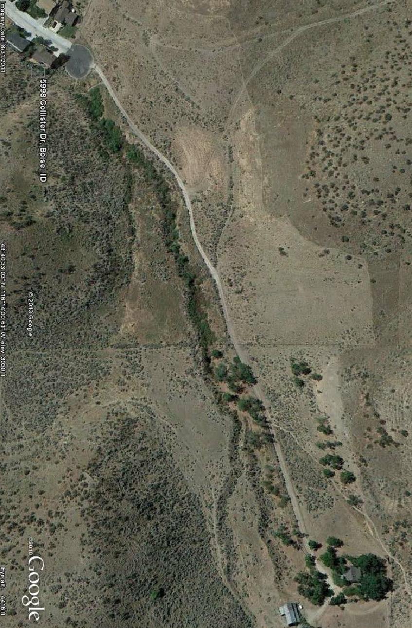
2 March 11, 2013 The following list of trail head issues and design elements was developed by Briarhill 2/3 neighborhood residents living near the end of Collister Dr. to mitigate the concerns related to the proposed Polecat Gulch trail head to be installed nearby. These contributors represent a group who has an intimate knowledge of the history, characteristics, and values of the Polecat gulch natural area. Also, this group will be highly impacted by the effects of the proposed trail head and will endure those effects for many years to come. We hope the city will use our knowledge and understand our concerns so we may live in harmony with the facility and the people it will bring. Please give our list of priorities thoughtful consideration and incorporate these elements into the design proposals for the trail head. This list is not intended to be an allinclusive list of all the concerns. Rather, it represents the minimum standards for the major issues. Hopefully the city will conduct their due diligence and implement the trail head with thoughtful and thorough design. Further, we wish to be included in future Polecat trail head development decisions. We respectfully submit this list of priority issues and welcome discussion or feedback regarding their feasibility. The following names have contributed to or currently support the ideas expressed herein: John Watts, 5954 Collister Dr. Boise, Id. Katy Watts, 5954 Collister Dr. Boise, Id. Gabriel Garber, 5999 Collister Dr. Boise, Id. Katherine Young, 5998 Collister Dr. Boise, Id. Daniel Young, 5998 Collister Dr. Boise, Id. Neil Handyside, 5971 Collister Dr. Boise, Id. Mary Handyside, 5971 Collister Dr. Boise, Id. Riley Fuller, 5985 Collister Dr. Boise, Id. Andrea Wisnefsky, 5985 Collister Dr. Boise, Id. Robert Cooke, 5985 Collister Dr. Boise, Id. Skyler Parker, 5985 Collister Dr. Boise, Id. Kraig Hutchinson, 5985 Collister Dr. Boise, Id. Milt Coffman, 5471 Collister Dr. Boise, Id. Shawn Rebholz, 5955 Collister Dr. Boise, Id. Patrick Courtright, 5612 Collister Dr. Boise, Id. Mariah Courtright, 5612 Collister Dr. Boise, Id. 1
3 I. SITE LOCATION: Residents support an analysis of placing the trail head further away from the neighborhood to minimize negative effects of the proposed trail head including noise and potential fires. By placing the trail head only 500 feet further away, the conditions residents currently value and enjoy such as privacy, serenity, security, and aesthetics will be maintained. A. The City of Boise needs to consider placing trail head at proposed design represented in Exhibit A. B. Corresponding road construction offers improvement of a substandard, narrow, rutted road that is sloping towards the gulch. Additional length of road improvement will provide a safe and adequate corridor for trail users, emergency vehicles, fire trucks, goat hauling trailers, tenant horse trailer, etc., accessing the existing farm house or trail system. II. UNAUTHORIZED/ILLEGAL ACTIVITY: This area has a history of attracting people who wish to engage in criminal activity. Within the last year, residents living at the end of Collister Dr. have been involved in several dangerous incidents by people seeking a nearby rural area to conduct illegal activity in. The following designs elements help mitigate this problem: A. GATE: Installing a gate at the cul-de-sac to close the trail head at night remains a top priority for the Briarhill neighborhood residents. Closing the parking lot at night will lower the potential for crime, disturbance and fires. Gate should be automatically controlled to ensure reliable access to trail head users in the daytime and neighborhood security at night. Exhibit D offers an example of an operating schedule. Gate should include an automatic sensor in road to allow vehicles to exit from inside the site after dusk, when gate is closed. The city s alternative of a one-way tire shredder seems dangerous as bike and pedestrian traffic will likely use this entrance after hours and in low light conditions. B. Install a light pole in the cul-de-sac C. Include a pedestrian/bike passage next to gate at cul-de-sac. D. Install sign at gate with operating schedule. 2
4 E. Install pole fencing around cul-de-sac and around trail head to prevent unauthorized vehicle use off roads. A retaining wall along the northwest side of improved road should be used to aid in unauthorized off road vehicle use. Examples of pole fencing are shown in Exhibit B and Exhibit C. III. FIRE: With an increase in vehicles and people at this trail head, the potential for fire is greatly increased. With vast acres of foothills land above this trail head and homes nearby, the risk of fire must be mitigated. The location of the city s chosen trail head concept places the trail head only 500 feet from existing homes. With the intervening fuel load composed of grass, bushes and sagebrush, little response time is allowed for home evacuation in the event of a fire. This poses a great risk to life and property. A. Move trail head location further away from residents. B. Close the trail head parking lot at night. C. Place no smoking/no fireworks signs at trail head kiosk. D. Mow vegetation on city property to create a fire break where city property imposes a hazard to private property that cannot be mitigated by property owners. E. Conduct hazardous fuels reduction around trail head. Residents support continuation of the goat renting program. F. Update FIRE-UP survey of this urban interface. Analyze Firewise measures that can be implemented. G. Consult with the city and BLM regarding a fire response strategy. Ensure city and BLM fire engines can access gulch and gates. IV. SAFETY: The Collister road and cul-de-sac often have children playing and riding bikes on the pavement. The increased traffic associated with the proposed trail head will pose an increased risk to children. Ensuring their safety is a priority. A. Install additional speed limit signs. 3
5 B. Install no parking anytime signs with double arrows to prevent culde-sac parking. C. Consider traffic calming measures. D. Have city police intermittently monitor and enforce speed limits. V. ROAD DESIGN: The nature of the current dirt track road will require thoughtful reconstruction for long term stability. Due to the granitic and clay soils, the stability and surface conditions are often in variable and poor condition. Portions of the road are currently sloughing off towards the gulch. During wet weather, portions become muddy and slick. This project provides an opportunity to improve the entire length of the road to the farm house for multiple public benefits. A. Road design elements should provide adequate and appropriate slope stabilization, drainage, sub-base depth, and surface material to ensure long term road integrity. B. Slope retention along the northwesterly side of the road will require a permanent, anchored retaining wall to eliminate road slip and bank erosion. C. Regardless of the site chosen for the parking lot, road improvement to the farmhouse offers important value and should be considered. VI. TRAIL HEAD DESIGN: There has been much discussion on the expected level of use this proposed trail head will receive. The neighborhood consensus is that the existing Cartwright Road trail head to the Polecat trail system is better suited as a primary trail head for the system and should be managed as such. The proposed Collister Dr. site should act as a secondary trail head. The Cartwright trail head has better public road access and has better potential for development to accommodate amenities such as horse trailer parking, additional stalls, and bathroom facilities. A. Consider placing a vault toilet at both the Cartwright and Collister trail heads to encourage balanced use at both trail head sites. If cost becomes an issue, a vault toilet at the Collister site would be a lower priority at this time. Future need could then be analyzed and accommodated. 4
6 B. A parking lot with stalls appears suitable and should adequately handle peak use at the Collister site. C. Pole fencing should be installed around parking lot. D. Horse trailer access at the Collister site is strongly opposed. The Collister road and site conditions are not suitable for horse trailer traffic. The Cartwright trail head offers better horse trailer access. E. The city s proposed site will negatively affect the privacy, view shed and tranquility of existing residents. These values are reasons residents have chosen to live in this area. Mitigation measures have been suggested such as lowering the parking lot and building a berm. Since the city s proposed site is on a sloped hillside with end view of parking lot facing homes, it appears the suggested mitigation measures can do little to mitigate the privacy and aesthetic concerns. Should the city s site proposal be imposed, adequate mitigation measures need to be further analyzed to determine if better measures exist. Trail head location at the alternative option expressed in Exhibit A would eliminate need to install proposed privacy mitigation measures. F. A year or so after the implementation of the Polecat trail head, a general analysis of the impacts, both good and bad, should be conducted to better create the kind of trail head the city, users and residents want. Issues that should be analyzed are those expressed within including levels of use, adequate facilities and mitigation of negative effects. The Briarhill 2/3 neighborhood would like to be involved in future development and management issues related to the Polecat trail head. Sincerely, Residents of the Briarhill 2/3 neighborhood. 5
7
8
9
10 GATE SCHEDULE CITY OF SCOTTSDALE MCDOWELL SONORAN PRESERVE Lost Dog Wash, Sunrise Trailhead Gateway, and Tom s Thumb Trailheads Open Close Open Close January 1 st 7:02 am 5:31 pm 7:02 am 5:01 pm January 15 th 7:02 am 5:42 pm 7:02 am 5:12 pm February 1 st 6:54 am 5:59 pm 6:54 am 5:29 pm February 15 th 6:42 am 6:12 pm 6:42 am 5:42 pm March 1 st 6:25 am 6:25 pm 6:25 am 5:55 pm March 15 th 6:07 am 6:36 pm 6:07 am 6:06 pm April 1 st 5:45 am 6:49 pm 5:45 am 6:19 pm April 15 th 5:27 am 6:59 pm 5:27 am 6:29 pm May 1 st 5:09 am 7:11 pm 5:09 am 6:41 pm May 15 th 4:57 am 7:22 pm 4:57 am 6:52 pm June 1 st 4:49 am 7:33 pm 4:49 am 7:03 pm June 15 th 4:47 am 7:39 pm 4:47 am 7:09 pm July 1 st 4:42 am 7:42 pm 4:42 am 7:12 pm July 15 th 4:59 am 7:38 pm 4:59 am 7:08 pm August 1 st 5:11 am 7:27 pm 5:11 am 6:57 pm August 15 th 5:20 am 7:13 pm 5:20 am 6:43 pm September 1 st 5:32 am 6:52 pm 5:32 am 6:22 pm September 15 th 5:41 am 6:33 pm 5:41 am 6:03 pm October 1 st 5:52 am 6:11 pm 5:52 am 5:41 pm October 15 th 6:03 am 5:53 pm 6:03 am 5:23 pm November 1 st 6:17 am 5:35 pm 6:17 am 5:05 pm November 15 th 6:30 am 5:25 pm 6:30 am 4:55 pm December 1 st 6:44 am 5:20 pm 6:44 am 4:50 pm December 15 th 6:55 am 5:21 pm 6:55 am 4:51 pm Notes: Gate times are changed the first and fifteenth of each month to coincide with the change in day length through the year. In general, the gates will open 30 minutes prior to the official sunrise and close at sunset, with the exception of the Sunrise Access Area, which closes 30 minutes before sunset to reduce impacts on the adjacent neighborhood. If the first or the fifteenth fall on a Saturday, the gate open/close time will be changed on Friday. If it falls on a Sunday, it will be changed on Monday. Updated December, 2012
Nov. 19 th Public Workshop Summary
 On November 19 th, more than 60 community members attended an Open Space Matters workshop at the Linen Building in downtown Boise for over two hours. Participants learned about reserves, discussed the
Logo Department Name Agency Organization Organization Address Information 5700 North Sabino Canyon Road
 Logo Department Name Agency Organization Organization Address Information United States Forest Coronado National Forest 5700 North Sabino Canyon Road Department of Service Santa Catalina Ranger District
City of Durango 5.8 FUNDING TRAILS DEVELOPMENT
 5.8 FUNDING TRAILS DEVELOPMENT The City has been successful in establishing dedicated local funding sources as well as applying for grants to develop the City s trail system, having received nearly $2.4
Appendix 3. Greenway Design Standards. The Whitemarsh Township Greenway Plan
 Appendix 3 Greenway Design Standards This chapter discusses two design standards for the greenway types discussed above. First, trail design standards are presented together with trailhead facilities and
MPRB: Southwest LRT Community Advisory Committee Issues and Outcomes by Location Current to: 12 November 2010
 MPRB: Southwest LRT Community Advisory Committee Issues and Outcomes by Location Current to: 12 November 2010 This is a compilation of issues and outcomes identified by the CAC. It is a work in progress,
Understanding user expectations And planning for long term sustainability 1
 Understanding user expectations And planning for long term sustainability 1 What is a natural surface trail? It can be as simple has a mineral soil, mulched or graveled pathway, or as developed as elevated
Trail Assessment Report
 Trail Assessment Report Trail Options for the Bear Creek Canyon located in Pikes Peak Ranger District, Pike National Forest and on Colorado Springs Utility Lands Due to the presence of a unique species
Citrus Heights Creek Corridor Trail Project. Trail Advisory Group Meeting #3 July 8, 2013
 Citrus Heights Creek Corridor Trail Project Trail Advisory Group Meeting #3 July 8, 2013 Agenda Introductions Recap: Community Workshop, Survey Findings, and TAG Field Trip Community Concern Discussion:
Citrus Heights Creek Corridor Trail Project Trail Advisory Group Field Trip #2 September 11, :00 11:00 am Trellis Hall, Citrus Heights
 September 11, 2013 9:00 11:00 am Trellis Hall, Citrus Heights Project Overview The City of Citrus Heights is studying the feasibility of establishing a multi use trail system within the City s 26 miles
Lake Tahoe Airport Master Plan Public Meeting March 16, 2015
 Lake Tahoe Airport Master Plan Public Meeting March 16, 2015 What is an Airport Master Plan? a comprehensive study of an airport [that] usually describes the short, medium, and long term development plans
D1 January 8, 2014 Public Hearing APPLICANT: HUNT CLUB FARM
 D1 January 8, 2014 Public Hearing APPLICANT: HUNT CLUB FARM PROPERTY OWNER: HUNT CLUB A-1- A, LLC. STAFF PLANNER: Kevin Kemp REQUEST: Modification of a Conditional Use Permit approved by the City Council
RECREATION. Seven issues were identified that pertain to the effects of travel management on outdoor recreation within portions of the project area.
 RECREATION Seven issues were identified that pertain to the effects of travel management on outdoor recreation within portions of the project area. OPPORTUNITIES FOR SOLITUDE / QUIET TRAILS. One attraction
Trail Feasibility Study
 VOLUSIA COUNTY MPO CITY OF NEW SMYRNA BEACH FINAL REPORT JUNE 30, 2009 Trail Feasibility Study What s inside? 1 Introduction 2 Project Purpose & Scope 3 Physical Inventory & Assessment of Right-of- Way
2. Goals and Policies. The following are the adopted Parks and Trails Goals for Stillwater Township:
 D. PARKS AND TRAILS 1. Introduction Stillwater Township s population is relatively low, with most residents living on rural residences on large lots. The need for active park space has been minimal in
Rule Governing the Designation and Establishment of All-Terrain Vehicle Use Trails on State Land
 Rule Governing the Designation and Establishment of All-Terrain Vehicle Use Trails on State Land 1.0 Authority 1.1 This rule is promulgated pursuant to 23 V.S.A. 3506. Section 3506 (b)(4) states that an
DISTRICT OF SQUAMISH
 DISTRICT OF SQUAMISH A G E N D A For the Meeting of the Smoke Bluffs Park Advisory Committee to be Held on Thursday, October 3, 2013 at 7:00 pm in Council Chambers, 37955 Second Avenue, Squamish BC 1.
Blue River Trail Master Plan JSA to Town Hall June 2004
 Blue River Trail Master Plan JSA to Town Hall June 2004 Prepared for: Silverthorne Town Council Silverthorne SPORT Committee Department of Recreation and Culture Silverthorne Public Works Silverthorne
MORGAN CREEK GREENWAY Final Report APPENDICES
 APPENDICES MORGAN CREEK GREENWAY Appendix A Photos of Existing Conditions in Trail Corridor Photos of existing conditions Main trail corridor - February 2009 Photos of existing conditions south bank Morgan
LAS VARAS RANCH CA COASTAL TRAIL PROPOSED ALIGNMENT
 LAS VARAS RANCH CA COASTAL TRAIL PROPOSED ALIGNMENT Santa Barbara Trails Council * Prepared by Ray Ford February 1,2012 The following notes accompany the Santa Barbara Trails Council map for the Las Varas
Permeable RECREATIONAL TRAILS
 SMART EARTH SOLUTIONS Permeable RECREATIONAL TRAILS GEOWEB GEOPAVE GEOTERRA Innovative Solutions for Designing & Building Trails. Trail Surface Stabilization The key to planning and building trails into
The Chu property is a 6.57 acre parcel located in the Town of Superior on the west side of McCaslin Boulevard. In 2014, the Town of Superior acquired
 1 The Chu property is a 6.57 acre parcel located in the Town of Superior on the west side of McCaslin Boulevard. In 2014, the Town of Superior acquired the Chu property for open space with a contribution
Trail # NW Tuesday, June DESIGN. Provide an Review the Provide an. Project Goals: System system. wayfinding
 I. Welcome / Introductions Bethany Creek Trail #2 Segment 3 Neighborhood Meeting #1 Bethany Presbyterian Church 15505 NW Springville Road, Portland, OR 97229 Tuesday, June 26, 2018 @ 6:00PM Meeting Minutes
Section 61 Recreational Vehicle Park / Campground (Bylaw No. 2012/10)
") Part 7 General Regulations Section 61 Recreational Vehicle Park / Campground (Bylaw No. 2012/10) 61.1 A comprehensive site plan shall be provided to the satisfaction of the Development Authority that shows
Part 7 General Regulations Section 61 Recreational Vehicle Park / Campground (Bylaw No. 2012/10) 61.1 A comprehensive site plan shall be provided to the satisfaction of the Development Authority that shows
Longmont to Boulder Regional Trail Jay Road Connection DRAFT FINAL REPORT
 Longmont to Boulder Regional Trail Jay Road Connection DRAFT FINAL REPORT December 2018 Project Summary Boulder County, Colorado, in partnership with the City of Boulder, is evaluating options for multi-use
BOAT DOCKS AND LAUNCHES. Public Engagement Report July 2015
 BOAT DOCKS AND LAUNCHES Public Engagement Report July 2015 TABLE OF CONTENTS BACKGROUND 3 STAKEHOLDER CONSULTATION 6 PARTICIPANT PROFILE 7 RESPONSE THEMES 8 CONCLUSION 16 BACKGROUND The North Saskatchewan
BUSINESS OF THE CITY COUNCIL CITY OF MERCER ISLAND, WA
 BUSINESS OF THE CITY COUNCIL CITY OF MERCER ISLAND, WA December 1, 2008 Public Hearing TOWN CENTER PARKING TIME LIMITS (FIRST READING) Proposed Council Action: Conduct public hearing and first reading
Bear Creek Habitat Improvement Project
 06/10/10 Bear Creek Habitat Improvement Project El Paso County, Colorado Pike National Forest and Colorado Springs Utilities Owned Land Report prepared by: Eric Billmeyer Executive Director Rocky Mountain
(213) phone (213) fax Wilshire Boulevard Suite 660 Los Angeles, CA
 phone (213) fax Wilshire Boulevard Suite 660 Los Angeles, CA") 3435 Wilshire Boulevard Suite 660 Los Angeles, CA 90010-1904 (213) 387-4287 phone (213) 387-5383 fax www.sierraclub.org Julia Yom, Park Planner County of Los Angeles Department of Parks and Recreation
3435 Wilshire Boulevard Suite 660 Los Angeles, CA 90010-1904 (213) 387-4287 phone (213) 387-5383 fax www.sierraclub.org Julia Yom, Park Planner County of Los Angeles Department of Parks and Recreation
Mountain Valley Pipeline, LLC Mountain Valley Pipeline Project Docket No. CP
 16. Prior to construction, Mountain Valley shall file with the Secretary, for review and approval by the Director of OEP, a segment-specific construction and operation access plan for the area between
American Conservation Experience
 ACE Project Report For Tonto National Forest, Arizona Trail Association and Arizona State Parks Title of Project: 4 Peaks Trail Maintenance Award Contract Number: ASP NM11021 Project Partner: Paul Burghard
RIVER ACCESS STRATEGY
 RIVER ACCESS STRATEGY The River Access Strategy is a 10-year plan the City of Edmonton is developing to inform future programming, operations and infrastructure improvements that support access to the
EXECUTIVE SUMMARY PROGRAM DEVELOPMENT REPORT PURPOSE EXISTING SETTING EXPANDING PARKLAND
 EXECUTIVE SUMMARY PROGRAM DEVELOPMENT REPORT PURPOSE As the culmination of the first phase of the master planning process, this Program Development Report creates the framework to develop the Calero County
AGENDA ITEM 5 D WAKULLA ENVIRONMENTAL INSTITUTE (WEI) TRAIL FEASIBILITY STUDY
 TRAIL FEASIBILITY STUDY") March 19, 2018 AGENDA ITEM 5 D WAKULLA ENVIRONMENTAL INSTITUTE (WEI) TRAIL FEASIBILITY STUDY TYPE OF ITEM: Action STATEMENT OF ISSUE The Wakulla Environmental Institute (WEI) Trail is one of several trails
March 19, 2018 AGENDA ITEM 5 D WAKULLA ENVIRONMENTAL INSTITUTE (WEI) TRAIL FEASIBILITY STUDY TYPE OF ITEM: Action STATEMENT OF ISSUE The Wakulla Environmental Institute (WEI) Trail is one of several trails
2016 Regional Transportation Alternatives Program (TAP) Grant Application
 Grant Application") 2016 Regional Transportation Alternatives Program (TAP) Grant Application PROJECT TITLE: Yelm-Tenino Trail Extension Feasibility Study TRPC use only GENERAL PROJECT INFORMATION Agency or Organization City
2016 Regional Transportation Alternatives Program (TAP) Grant Application PROJECT TITLE: Yelm-Tenino Trail Extension Feasibility Study TRPC use only GENERAL PROJECT INFORMATION Agency or Organization City
Finn Creek Park. Management Direction Statement Amendment
 Finn Creek Park Management Direction Statement Amendment November 2013 Management Direction Statement Amendment Approved by: Jeff Leahy Regional Director, Thompson Cariboo BC Parks November 12, 2013 Date
M621. Junctions 1 to 7 Improvement scheme. Share your views
 M621 Junctions 1 to 7 Improvement scheme Share your views Investing in your roads Every road user wants less congested roads to enable swift, safe, comfortable and informed travel. On behalf of the government,
Meeting Notes Public Open House
 Meeting Notes Public Open House, 5:30-8:00 pm Fairbanks Pipeline Training Center, 3605 Cartwright Court, Fairbanks, Alaska= Agenda: Open House: 30 minutes Presentation: 45 minutes Question and Answers:
Ridge to Rivers MINUTES. November 13, 2013
 Ridge to Rivers 1 st Quarter Partnership Meeting MINUTES Partners present: Doug Holloway and Julia Grant, Boise Parks and Recreation, Larry Ridenhour and Terry Humphrey, Bureau of Land Management (BLM),
Silver Creek Plunge Campground Reconstruction
 Silver Creek Plunge Campground Reconstruction PROPOSED ACTION REPORT Emmett Ranger District Boise National Forest 1805 Highway 16, Room 5 Emmett, Idaho 83617 November 2009 Silver Creek Plunge Campground
2. STAKEHOLDER FEEDBACK // What We Heard
 1. QUARRY ROAD TRAIL // Welcome to the Information Session PROJECT DESCRIPTION WHY WE ARE HERE Quarry Road Trail is a popular commuter trail and recreational area for Calgarians. 1. To report citizen feedback
BOISE RIDGE TO RIVERS FOURTH QUARTER PARTNERSHIP MEETING DEPARTMENT OF PARKS AND RECREATION TUESDAY, JULY 25 TH :00 A.M.
 BOISE RIDGE TO RIVERS FOURTH QUARTER PARTNERSHIP MEETING DEPARTMENT OF PARKS AND RECREATION TUESDAY, JULY 25 TH 2017 8:00 A.M. Partners present: Sara Arkle, Boise City Parks and Recreation (City); Doug
National Forests and Grasslands in Texas
 United States Department of Agriculture Forest Service National Forests and Grasslands in Texas Sam Houston NF 394 FM 1375 West New Waverly, Texas 77358 Phone 936-344-6205 Dear Friends, File Code: 1950
Seek the Board s approval for the Donald Place kerb and channel renewal to progress to final design, tender and construction; and
 3. DONALD PLACE - KERB AND CHANNEL RENEWAL General Manager responsible: General Manager City Environment Officer responsible: Transport and City Streets Manager Author: Michelle Flanagan, Streets Capital
Macleod Trail Corridor Study. Welcome. Macleod Trail Corridor Study Open House. Presentation of Proposed Design Concepts
 Macleod Trail Corridor Study Welcome Macleod Trail Corridor Study Open House Presentation of Proposed Design Concepts Study Purpose Develop a corridor plan for Macleod Trail that aligns with The City s:
ROAD AND TRAIL PROJECT APPROVAL
 ROAD AND TRAIL PROJECT APPROVAL www.marincountyparks.org Marin County Parks, 3501 Civic Center Dr, Suite 260, San Rafael, CA 94903 DATE: July 12, 2017 PRESERVE: Gary Giacomini Open Space Preserve PROJECT:
CHAPTER 4 -- THE LAND USE PLAN: DESCRIPTIONS AND POLICIES FOR THIRTEEN PLANNING AREAS
 CHAPTER 4 -- THE LAND USE PLAN: DESCRIPTIONS AND POLICIES FOR THIRTEEN PLANNING AREAS NORTH CENTRAL CAC AREA LITTLE VALLEY ROAD TO JUG HANDLE CREEK PLANNING AREA This planning area includes Cleone, Noyo,
Stephanie Sinnott, Executive Director, Finance, Office of the City Manager
 Public Report To: From: Finance Committee Stephanie Sinnott, Executive Director, Finance, Office of the City Manager Paul D. Ralph, BES, RPP, MCIP, Commissioner, Development Services Department Report
CHAPTER III: TRAIL DESIGN STANDARDS, SPECIFICATIONS & PERMITS
 CHAPTER III Trail Design Standards, Specifications & Permits This chapter discusses trail standards, preferred surface types for different activities, permits, and other requirements one must consider
With the first portion of this process complete, we anticipate the general timeline for the remainder of the process to be:
 THE CITY OF FIRE RESCUE E D M O N T O N FIRE RESCUE SERVICES 10351 96 Street Edmonton, Alberta T5H 2H5 April 19, 2013 Dear Rossdale residents: As many of you know, Fire Rescue Services is currently in
VI. ALTERNATIVES TO THE MASTER PLAN C. RENOVATED EAST BUILDING ALTERNATIVE
 VI. ALTERNATIVES TO THE MASTER PLAN C. RENOVATED EAST BUILDING ALTERNATIVE INTRODUCTION The Renovated East Building Alternative would include the continued use of the renovated West Building and the renovation
Calgary River Access Strategy Priority Sites and Proposed Funding
 Calgary River Access Strategy Priority Sites and Proposed Funding CPS2017-0103 ATTACHMENT 2 A total of $7,660,000 (Class 5 estimate) is required to implement all sites within the Calgary River Access Strategy;
Attachment D: PHOTO LOG CITY OF ARCATA RAIL-WITH-TRAIL CONNECTIVITY PROJECT
 01051-09004 Attachment D: PHOTO LOG CITY OF ARCATA RAIL-WITH-TRAIL CONNECTIVITY PROJECT DRAFT: June 30, 2010 Applicant: City of Arcata 736 F Street Arcata, CA 95521 Phone (707) 825-2154 Prepared by: Winzler
Kelly Motorized Trails Project Proposed Action
 Kelly Motorized Trails Project Proposed Action November 28, 2011 The Flagstaff Ranger District of the Coconino National Forest is seeking public input on the proposed Kelly Motorized Trails Project (formerly
Lake Tahoe Airport Master Plan
 Lake Tahoe Airport Master Plan City Council Briefing October 20, 2015 What is an Airport Master Plan? a comprehensive study of an airport [that] usually describes the short, medium, and long term development
RIO VISTA MUNICIPAL AIRPORT
 DRAINAGE TECHNICAL MEMORANDUM RIO VISTA MUNICIPAL AIRPORT RIO VISTA, CALIFORNIA Prepared for: City of Rio Vista 1 Main Street Rio Vista, CA 94571 (707) 374-5337 Prepared by: August 2012 Copyright 2012
Creating a User-Driven Long-Distance OHV Trail Through Partnering
 Joseph Raffaele Outdoor Recreation Planner U.S. Bureau of Land Management Yuma, Arizona Creating a User-Driven Long-Distance OHV Trail Through Partnering BLM is a multiple-use land management agency within
September 14, Comments of the Colorado Trail Foundation On the USFS Scoping Notice of August 13, 2010 RE: the relocation of the CDNST/CT Page 1
 THE COLORADO TRAIL FOUNDATION Comments on the U.S. Forest Service Scoping Notice of August 13, 2010 Regarding the Relocation of THE COLORADO TRAIL AND CONTINENTAL DIVIDE NATIONAL SCENIC TRAIL From La Garita
Perth and Kinross Council Development Control Committee 27 August 2008 Recommendation by Development Quality Manager
 Perth and Kinross Council Development Control Committee 27 August 2008 Recommendation by Development Quality Manager 5(7) 08/414 Erection of kennels and cattery at Baltree Farm, Hatchbank, Kinross, KY13
SOUTH INTERCHANGE AREA
 Santaquin City General Plan 1 Location and Characteristics The South Interchange Area of Santaquin is located west of Interstate 15 and south of 500 South (Figure 1). It includes properties already annexed
MUNICIPALITY OF ANCHORAGE
 MUNICIPALITY OF ANCHORAGE ANCHORAGE PARKS & RECREATION Memorandum PRC 08-56 DATE: 5 August 2008 TO: FROM: SUBJECT: Parks & Recreation Commission Holly Spoth-Torres, Park Planner PRC 08-56 Far North Bicentennial
A BOAT RAMP TO NOWHERE
 A BOAT RAMP TO NOWHERE A PROPOSAL FOR ACCESS TO HARVIE PASSAGE A Presentation to the City of Calgary December 2017 Presented by: Peter Crowe-Swords Bow River Trout Foundation Background: The Bow River
LYNDHURST NEW URBAN DEVELOPMENT AREA STRUCTURE PLAN. Lyndhurst New Urban Development Area Structure Plan OUTCOMES AND PERFORMANCE STANDARDS
 APPENDIX 15.1-3 LYNDHURST NEW URBAN DEVELOPMENT AREA STRUCTURE PLAN Purpose of the Structure Plan Lyndhurst New Urban Development Area Structure Plan OUTCOMES AND PERFORMANCE STANDARDS LSP-P1 The District
El Dorado County COMMUNITY WILDFIRE PROTECTION PLAN Community Tab for AUBURN LAKE TRAILS FIRE SAFE COUNCIL ACTIVITIES
 El Dorado County COMMUNITY WILDFIRE PROTECTION PLAN Community Tab for AUBURN LAKE TRAILS FIRE SAFE COUNCIL ACTIVITIES Prepared for Inclusion in the: EL DORADO COUNTY FIRE SAFE COUNCIL Community Wildfire
Welcome to the future of Terwillegar Park a Unique Natural Park
 Welcome to the future of Terwillegar Park a Unique Natural Park 1 Introduction The Terwillegar Park Concept Plan study will develop an overall concept plan, management objectives and development guidelines
GOLDEN EARS PROVINCIAL PARK
 GOLDEN EARS PROVINCIAL PARK Trail Information as of October 10 th 2015 Do not underestimate the mountainous wilderness of Golden Ears Provincial Park. The combination of rugged terrain and rapidly changing
PLANNING COMMISSION AGENDA REPORT May 10, Members of the Planning Commission. Joyce Parker-Bozylinski, Contract Planner
 PLANNING COMMISSION AGENDA REPORT May 10, 2007 TO: FROM: PROPOSAL: APPLICANT: RECOMMENDATION: Members of the Planning Commission Joyce Parker-Bozylinski, Contract Planner Approval of the Calabasas Trails
Ridge to Rivers MINUTES. February 5, 2014
 Ridge to Rivers 2 nd Quarter Partnership Meeting MINUTES Partners present: Scott Koberg, Ada County Parks and Waterways, Doug Holloway and Julia Grant, Boise City Department of Parks and Recreation, Larry
DRAFT - APRIL 13, 2007 ROUTING STUDY FOR TRAIL CONNECTIONS BETWEEN CALAIS AND AYERS JUNCTION
 DRAFT - APRIL 13, 2007 ROUTING STUDY FOR TRAIL CONNECTIONS BETWEEN CALAIS AND AYERS JUNCTION Abstract The vision for the East Coast Greenway is an off-road urban trail system running from Calais, Maine
Central Cascades Wilderness Strategies Project
 Central Cascades Wilderness Strategies Project Wilderness is Unique What makes designated Wilderness different from other national forest lands? Wilderness Act of 1964 to assure that an increasing population
Park Design and Location Criteria
 Park Design and Location Criteria This section is presented in the interest of assisting park and recreation agencies in the development of a system of parks and recreation areas. A recreation system is
HIGHWAY RAIL GRADE CROSSING CONSOLIDATION PROGRAM
 HIGHWAY RAIL GRADE CROSSING CONSOLIDATION PROGRAM To decrease unnecessary train traffic exposure to life and property, promote public safety, and improve traffic conditions, the Texas Department of Transportation
Welcome and thank you for being here! Kick-Off Public Workshop November 19, 2014
 Welcome and thank you for being here! Kick-Off Public Workshop November 19, 2014 OPEN SPACE MATTERS: Boise s First Reserve Master Plan Julia Grant Foothills and Open Space Manager City of Boise Ellen Campfield
Description of the Proposed Action for the Big Creek / Yellow Pine Travel Plan (Snow-free Season) and Big Creek Ford Project
 and Big Creek Ford Project") Description of the Proposed Action for the Big Creek / Yellow Pine Travel Plan (Snow-free Season) and Big Creek Ford Project Payette National Forest Krassel Ranger District Valley and Idaho Counties, Idaho
Description of the Proposed Action for the Big Creek / Yellow Pine Travel Plan (Snow-free Season) and Big Creek Ford Project Payette National Forest Krassel Ranger District Valley and Idaho Counties, Idaho
Fall 2014 Open House and Feedback Summary
 Fall 2014 Open House and Feedback Summary Overview 12/4/14 Puget Sound Energy (PSE) hosted an online open house from Nov. 3 to Nov. 21, 2014 and two in-person open houses on Nov. 12 and 13. At these open
PROPOSED PARK ALTERNATIVES
 8 Chimne y Rock State Park M a ster Pl an 2011 PROPOSED PARK ALTERNATIVES Introduction Three different park development concepts were prepared and presented to the citizens of North Carolina through a
Mt. Hood National Forest
 United States Department of Agriculture Forest Service Mt. Hood National Forest Zigzag Ranger District 70220 E. Highway 26 Zigzag, OR 97049 503-622-3191 Fax: 503-622-5622 File Code: 1950-1 Date: June 29,
Kennesaw Mountain Trail Club. Trail Skills Workshop ~ Dips and Drains. Presented by: Jay M Dement
 Kennesaw Mountain Trail Club Trail Skills Workshop ~ Dips and Drains Presented by: Jay M Dement KEY CONCEPTS: Control Erosion and Users Where Do Trails Come From, and How Do They Work: Concept of trail
IL 390 Station. Wood Dale Open House Summary 5/18/17
 Wood Dale Open House Summary 5/18/17 The first public open house for the Wood Dale Comprehensive Plan took place on May 18 th, 2017. The program was conducted as a fun community event and there were 216
Tour of the Rancho Mission Viejo Riding Park at San Juan Capistrano Eastern Open Space JULY 2016
 Tour of the Rancho Mission Viejo Riding Park at San Juan Capistrano Eastern Open Space JULY 2016 Text of Measure Y Health & Safety Issues One of four horse washing stations (left) next to Federally & State
Chorley Park Trail Connection New Design Options. Information Booklet Prepared for June 9, 2014 Public Meeting
 Chorley Park Trail Connection New Design Options Information Booklet Prepared for June 9, 2014 Public Meeting Chorley Park Trail Booklet June 9, 2014 Page 1 of 12 Our Goals for the Chorley Park Trail Connection
Wilds. Headwaters. Lakes. Oxbows. Falls
 56 5 4 3 Wilds Headwaters Lakes Oxbows Falls 57 Zones It could be said the on-the-ground essence of this master plan appears within the next 6 pages of this report. As we learned in the preceding Cultural
Alternative 3 Prohibit Road Construction, Reconstruction, and Timber Harvest Except for Stewardship Purposes B Within Inventoried Roadless Areas
 Roadless Area Conservation FEIS Summary Table S-1. Comparison of Key Characteristics and Effects by Prohibition Alternative. The effects summarized in this table A would occur in inventoried roadless areas
Airport Planning Area
 PLANNING AREA POLICIES l AIRPORT Airport Planning Area LOCATION AND CONTEXT The Airport Planning Area ( Airport area ) is a key part of Boise s economy and transportation network; it features a multi-purpose
Preferred Recreation Recommendations Stemilt-Squilchuck Recreation Plan March 2018
 Preferred Recreation Recommendations Stemilt-Squilchuck Recreation Plan March 2018 Below are the recommended recreation ideas and strategies that package together the various recreation concepts compiled
HARBOR BRIDGE PROJECT COMMUNITY ADVISORY BOARD MEETING MINUTES April 5, 2018
 HARBOR BRIDGE PROJECT COMMUNITY ADVISORY BOARD MEETING MINUTES April 5, 2018 The following notes are the Texas Department of Transportation s (TxDOT) summary of the meeting and are not designed to be an
Blackburn Road Blackburn Level Crossing Removal. Frequently Asked Questions August 2014 GENERAL
 Frequently Asked Questions August 2014 Blackburn Road Blackburn Level Crossing Removal GENERAL What is the project? The Victorian Government has committed to eliminating a number of the busiest level crossings
Regional Wayfinding Sign Strategy Thurston County Trails 2017
 Regional Wayfinding Sign Strategy Thurston County Trails 2017 Partners: Members and partnering organizations of the Thurston Thrives Community Design Action Team City of Lacey, City of Olympia, City of
City of Fremantle. Joel Levin, Aha! Consulting INTRODUCTION 2 BACKGROUND 3
 -- WORKSHOP REPORT -- Project: Client: Event: South Beach Basketball Court City of Fremantle Community Consultation Forum Date: 12 th November 2015 6:00pm 8:00pm Author: Joel Levin, Aha! Consulting Contents:
Appendix A Appendix A (Project Specifications) Auk Auk / Black Diamond (Trail 44) Reroute
 Auk Auk / Black Diamond (Trail 44) Reroute") Appendix A (Project Specifications) Auk Auk / Black Diamond (Trail 44) Reroute I. Proposed Action: This project proposes to reroute approximately 1,800 feet of a 50 inch wide trail, off of private property
Appendix A (Project Specifications) Auk Auk / Black Diamond (Trail 44) Reroute I. Proposed Action: This project proposes to reroute approximately 1,800 feet of a 50 inch wide trail, off of private property
Georgetown-Lewes Rail/Trail Study. Rail/Trail Study: Cool Spring to Cape Henlopen State Park New Road Extension (House Resolution No.
 Georgetown-Lewes Rail/Trail Study Rail/Trail Study: Cool Spring to Cape Henlopen State Park New Road Extension (House Resolution No. 47) August 22, 2011 Presentation Outline Background Benefits Statewide
2017 Budget & Policy Priorities
 2017 Budget & Policy Priorities Fully Fund Minnesota State Parks and Trails No New Taxes for State Trail Users Keep State Parks Free from the Noise and Undue Artificiality of OHVs Operations Budget: Fully
Fossil Creek Wild & Scenic River Comprehensive River Management Plan Forest Service Proposed Action - details March 28, 2011
 Fossil Creek Wild & Scenic River Comprehensive River Management Plan Forest Service Proposed Action - details March 28, 2011 Primary Goals of the Proposed Action 1. Maintain or enhance ORVs primarily by
November 11, Subject: Public Scoping Meeting November 9, 2016 Public Comments and Response. Dear Ken:
 November 11, 2016 Mr. Ken Nichols City and Borough of Juneau Juneau International Airport Planning, Design and Construction 1873 Shell Simmons Dr., Ste. 200 Juneau, Alaska 99801 Subject: Public Scoping
Priscilla Davenport, Saluda District
 AT A MEETING OF THE MIDDLESEX COUNTY PLANNING COMMISSION HELD ON THURSDAY, NOVEMBER 13, 2003, IN THE PUBLIC MEETING ROOM OF THE COOK S CORNER OFFICE COMPLEX, COOK S CORNER, VIRGINIA. Present: Absent: John
Dungeness Recreation Area County Park Master Plan
 Dungeness Recreation Area County Park Public Outreach Meeting October 10, 2007 Project Overview USFWS Site Dungeness Recreation Area County Park Meeting Objectives: Re-Introduce project; provide status
COMMUNITY MEETING NOVEMBER 1, Wheaton Regional Park Pine Lake Trail
 COMMUNITY MEETING NOVEMBER 1, 2012 MEETING AGENDA I. Introduction of Project Team II. Trail Renovation Process III. Wheaton Regional Park IV. Pine Lake Trail Renovation Project V. Comments and Questions
METROPOLITAN COUNCIL 390 North Robert Street, St. Paul, MN Phone (651) TDD (651)
 TDD (651)") METROPOLITAN COUNCIL 390 North Robert Street, St. Paul, MN 55101 Phone (651) 602 1000 TDD (651) 291 0904 DATE: June 19, 2007 TO: Metropolitan Parks and Open Space Commission FROM: Jan Youngquist, Senior
METROPOLITAN COUNCIL 390 North Robert Street, St. Paul, MN 55101 Phone (651) 602 1000 TDD (651) 291 0904 DATE: June 19, 2007 TO: Metropolitan Parks and Open Space Commission FROM: Jan Youngquist, Senior
Hudson Highlands Fjord Trail Draft Master Plan. April 29, 2015
 Hudson Highlands Fjord Trail Draft Master Plan April 29, 2015 Agenda Route Overview Proposed Segment Results of Community Survey on that Segment Next Steps Municipal Endorsement Environmental Review Implementation
Rural Rustic Road Program
 Virginia Department of Transportation s Rural Rustic Road Program Prepared by the Local Assistance Division Virginia Department of Transportation 1401 East Broad Street Richmond, Virginia 23219 Michael
CALL TO ORDER Chairman Tillman called the meeting to order at 6:00 p.m.
 PLANNING BOARD MEETING THURSDAY JUNE 25, 2009 PRESENT Greg Tillman, Mike Morasco, Tom Dwyer, Jr., Steve Colby; Selectmen s Representative Karen Sott; Alternate Dave Crowell; Secretary Phyllis McDonough.