Of the Virginia Coal Heritage Trail
|
|
|
- Edmund Bates
- 5 years ago
- Views:
Transcription

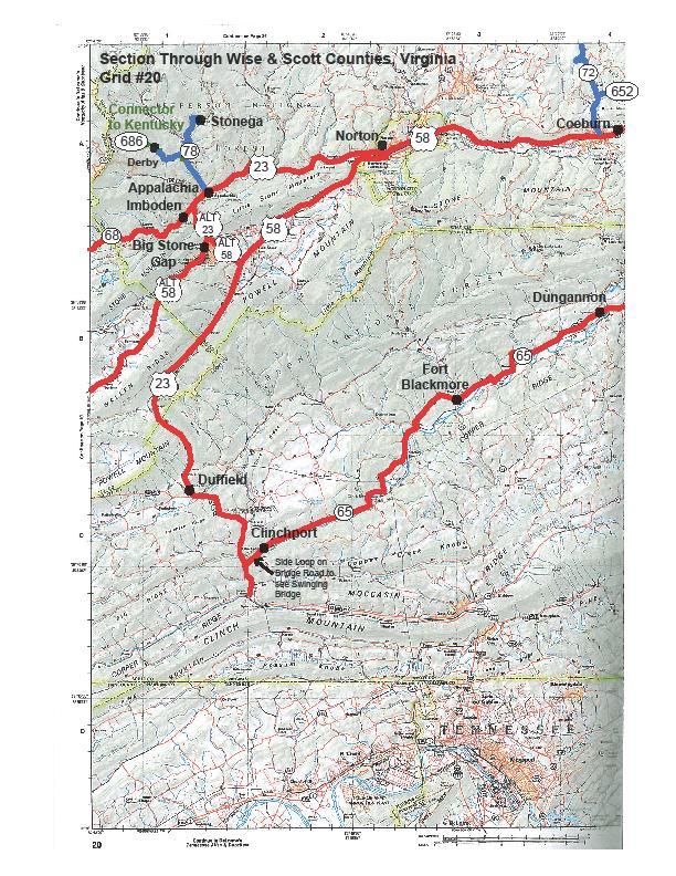
1 CHAPTER III: ROUTE, MAPS & ROAD DESCRIPTIONS On the Virginia Coal Heritage Trail This Chapter addresses the #1 FHWA requirement for a CMP by providing maps identifying the corridor boundaries, location of intrinsic qualities, and land uses in the corridor. U. S. Geological Survey maps highlighting the routes are located on pages 33 thru 39. A mile by mile inventory of the route is provided in Appendix A and includes both descriptions and photos. This chapter also provides recommendations and suggestions for modifying the route to make it possible for all vehicle types to travel the route as well as include some byway intrinsic qualities that may otherwise be missed (#13 on the FHWA requirements). An evaluation of design standards and how proposed changes may affect the byway's intrinsic qualities has not been fully addressed. In 2007, the Virginia Department of Transportation erected state byway signage along the entire byway route. We sincerely applaud their work. They did an excellent job in making sure a traveler not familiar with the route nor the area could find their way. This chapter provides a breakdown of the entire route and detailed maps of the Pocahontas to St. Paul Trail, St. Paul Loop and Norton Loop. There are only a few places where additional signs are needed to avoid confusion and to provide either confirmation or a warning of an upcoming turn in the route. These sign locations are noted in both CHAPTER VII: Issues to Address and in APPENDIX A: Snapshot View of the Byway. Signage along State Byway Byway signage is also needed: Directing travelers traveling the Pocahontas to St. Paul Trail to: - Take Business 421 through Cedar Bluff. - Go through the communities of both Richlands and Jewell Ridge. - Turn left on Hwy 680 to Hwy 460 to take the historic route through Buchanan County or right on Hwy 628 for the more scenic route. - Sign at Bearwallow Road to go through the community of Dante - And the left turn off Hwy 63 at the light through the Town of St. Paul. Directing travelers traveling the St. Paul Loop to: - Get into the right lane and turn right onto Hwy 65 (Mew Road) coming off of Hwy 58 otherwise one will miss the turn. - Take Hwy 23 E down to the dam and past the interpretive display and scenic pull-off for the Copper Creek Railroad Trestle. - Take Hwy 72 through downtown Coeburn and Tom s Creek. Directing travelers traveling the Norton Loop 9
2 - Turn onto Hwy 600 in downtown Appalachia which takes one to the coal towns of Stonega and Derby (two of the most complete coal towns along the entire route). - Through the community of Big Stone Gap, taking one past the Coal Museum and other designated sites along the route. Recommendation: The Virginia Coal Heritage Advisory Committee and participating communities need to immediately follow-up with the Virginia Department of Transportation (V-DOT) to ensure byway signage is installed at all necessary and remaining locations where it has been identified as a need. Note: Action has already been taken with V-DOT to address the byway sign recommended at the turn-off from Hwy 58 onto Mew Road (Hwy 65). DESCRIPTION OF ROUTE The Virginia Coal Heritage Trail officially begins at the Pocahontas Exhibition Mine in Pocahontas Virginia and travels 325 miles through seven counties. Each of the counties along the route developed individual brochures highlighting their particular section of the trail. The information contained in each of the brochures is provided online at trailsrus.com/vacoaltrail under each of the counties. Recognizing the fact that the average visitor would probably not be stopping at a county line, it was decided to provide overall maps of the entire route in each of the publications. MAP OF THE VIRGINIA COAL HERITAGE TRAIL STATE SCENIC BYWAY Working with the communities along the route, it was also decided that it would be best to divide the trail into three parts for better management as well as to enable the traveler to begin and end their trips in areas offering amenities such as gas, food and lodging. An inventory of basic amenities offered along the route is provided in APPENDIX B. 10


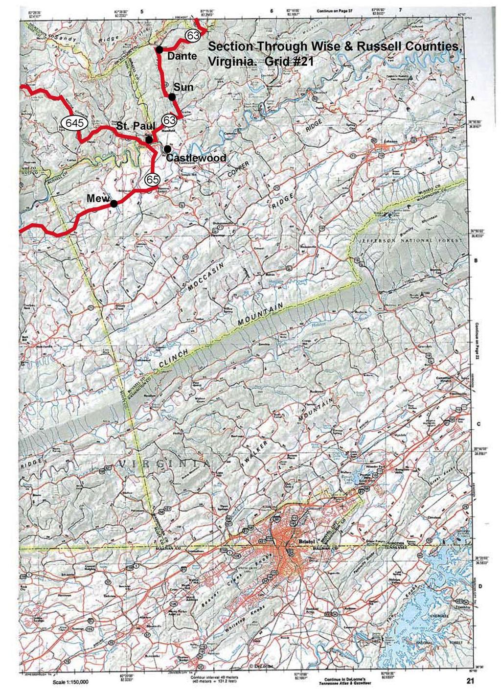
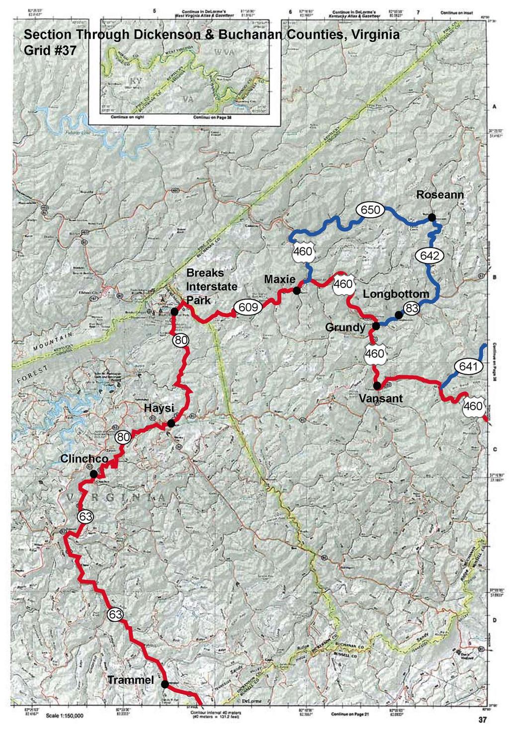
3 The route was divided into the Pocahontas to St. Paul Trail, the St. Paul Loop and the Norton Loop. The beauty of loops is that it enables the traveler to start anywhere along the trail and always end back where they originally started. Maps of each of the routes are provided on the following pages along with a short overview of the towns one will pass and a few of the sites one will see along the way. *Note: Recommended change in a section of the route through Buchanan County. See CHAPTER VIII: Public Participation Buchanan County for details. POCAHONTAS TO ST. PAUL TRAIL The Pocahontas Trail starts in Tazewell County, traveling through the counties of Buchanan, Dickenson, and Russell and ending at St. Paul near the Wise County/Russell County line. The main section of the trail starts in Pocahontas, the first and largest mining town in the Virginia coalfields. It is a continuous 157 mile trail from Pocahontas to the community of St. Paul through the counties of Tazewell, Buchanan, Dickenson, Russell & Wise. The primary stops along the way are in the communities of Pocahontas, Crab Orchard, Richlands, Jewell Ridge, Mountain Top Golf Course, Grundy, Breaks Interstate Park, Haysi, Clinchco, McClure, Dante, and St. Paul. There are over 50 coal-related sites visible from this section of the byway. Original route through Buchanan (shown above) Another unique feature of this particular trail is the community in which it starts (Pocahontas) is less than 4 miles from Bramwell WV, another historic coal camp community and a stop on West Virginia s National Coal Heritage Trail. ST. PAUL LOOP* The St. Paul Loops travels a short distance into Russell County before crossing into the counties of Scott, Lee, and Wise, ending back where one started. 11
4 The St. Paul Loop is an 87 mile section starts at St. Paul and travels along 58A, Hwy 65, U.S. 23 then back to Hwy 58A passing through or by the communities of St. Paul, Dungannon, Clinchfield, Duffield, Big Stone Gap, Norton, Tacoma, Coeburn, Tom s Creek before ending back at St. Paul. One has a choice of going either east or west on Hwy 58A but will eventually end back in St. Paul. The focus of this section is railroads and how they played an intricate part in the story of coal in Southwest Virginia. Included on this trip are two depots, trestles, the Natural Tunnel State Park, a railroad museum and more. NORTON LOOP* The Norton Loop travels through the City of Norton, Wise County, Lee County then back into Wise County before ending back where one started. The third section is also a loop that begins and ends wherever one starts. This 68-mile loop travels through downtown Norton through the communities of Appalachia, Pennington Gap and Big Stone Gap taking a few back roads past old and new mining camps such as Keokee, Exeter and Imboden. Many of these roads are curvy, twisty with just a few hairpin turns. Some of the back roads are not heavily traveled which makes this section ideal for motorcycles and those wanting a unique and interesting ride. Within this loop, there are over 30 coal-related sites to see. *As noted, loops enable the traveler to start anywhere along the trail and always end back where they originally started. More in-depth road descriptions for each section of the Virginia Coal Heritage Trail is provided towards the end of the chapter. On the following pages are topographical maps of the route. 12
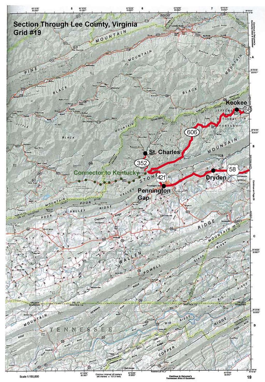
5 13
6 14
7 15
8 16
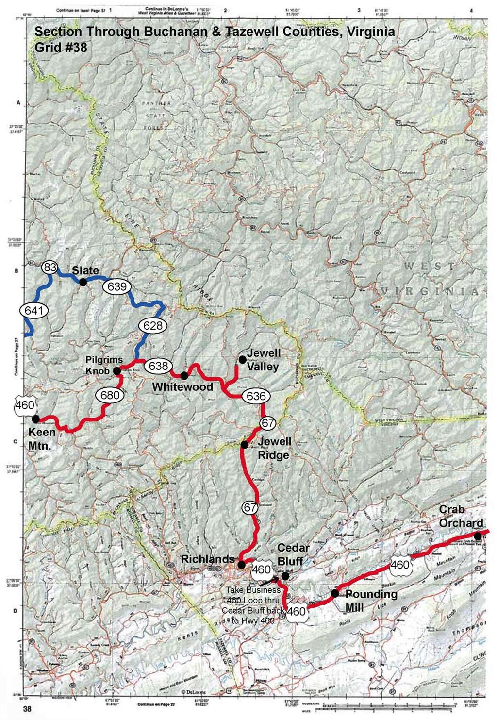
9 17
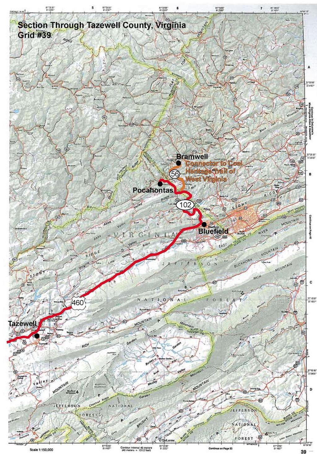
10 18
11 GENERAL HIGHWAY/ROAD INFORMATION The Virginia Coal Heritage Trail is located entirely within the Bristol District on paved roads. Below is an overall review of the types of roads, total miles and surface types in each of the counties. OVERALL MILES OF ROADS PER COUNTY Buchanan County Dickenson County Lee County Russell County Scott County Tazewell County Wise County Miles of Primary Roads Miles of Secondary Roads Miles of Primary Roads Miles of Secondary Roads Miles of Primary Roads 1, Miles of Secondary Roads Miles of Primary Roads 1, Miles of Secondary Roads Miles of Primary Roads 1, Miles of Secondary Roads 6.90 Miles of Frontage Miles of Primary Roads Miles of Secondary Roads 2.12 Miles of Frontage Miles of Primary Roads Miles of Secondary Roads 4.72 Miles of Frontage SURFACE TYPES COUNTY PORTLAND CEMENT CONCRETE BITUMINOUS CONCRETE TOTAL PAVED TOTAL HARD SURFACED BUCHANAN DICKENSON LEE RUSSELL SCOTT TAZEWELL WISE PRIMARY SURFACE COUNTY DIVIDED 4+ LANES 3 LANE 2 LANE BUCHANAN DICKENSON LEE RUSSELL SCOTT TAZEWELL WISE

12 CHAPTER III: ROUTES, MAPS, & ROAD DESCRIPTIONS PROPOSED COAL HERITAGE TRAIL NATIONAL SCENIC BYWAY ROUTE THROUGH SEVEN COUNTIES IN SW VIRGINIA This 300+ mile scenic byway goes past numerous coal camps, historic buildings, and beautiful vistas.
CHAPTER VII: ISSUES TO ADDRESS Along the Virginia Coal Heritage Trail
 CHAPTER VII: ISSUES TO ADDRESS This chapter addresses #4 FHWA requirement for a CMP which is to develop a strategy for for maintaining and enhancing each of the byway's intrinsic qualities including, but
RICH RAILROAD HISTORY Along the Virginia Coal Heritage Trail
 APPENDIX M Rich Railroad History In the process of developing a corridor management plan for the Virginia Coal Heritage Trail, it became clear the railroad played a huge role in the development of Southwest
Below is the section of the Byway discussed in the Wise/Russell County meeting. Primary coal sites are noted on the map.
 APPENDIX H: PUBLIC PARTICIPATION SERIES OF TOWN MEETINGS Virginia Coal Heritage Trail Corridor Management Plan Meeting in St. Paul on the Wise and Russell County portions of the St. Paul Loop September
CHAPTER X: INTERPRETING & MARKETING THE BYWAY For the Virginia Coal Heritage Trail
 CHAPTER X: INTERPRETING & MARKETING THE BYWAY Creation and implementation of a successful marketing plan is essential to achieving the desired economic benefits of the trail. The primary goal of all marketing
CHAPTER XII: ECONOMIC IMPACT Of the Virginia Coal Heritage Trail
 As noted earlier in this document, studies have determined that over 80% (118 million) of traveling U.S. adults are considered cultural heritage travelers. These tourists tend to stay multiple nights,
Below is the section of the Byway discussed in the Wise County meeting. Primary coal sites are noted on the map.
 APPENDIX H: PUBLIC PARTICIPATION SERIES OF MEETINGS Virginia Coal Heritage Trail Corridor Management Plan Meeting In Big Stone Gap on the Wise County portion of the Norton Loop September 20 th 2010 at
CHAPTER IX: ACTION PLAN Norton Loop
 CHAPTER IX ACTION PLAN FOR THE NORTON LOOP Through the City of Norton & the counties of Wise and Lee In the following section is an overview of the recommendations and plan for action for the section of
Pocahontas to St. Paul Trail
 CHAPTER IV: HIGHLIGHTS Along the The Virginia Coal Heritage Trail appropriately starts in Tazewell County at the Pocahontas Exhibition Mine, the site of the famous 12 vein, one of the largest and best
Below is the section of the Byway discussed in the Tazewell County meeting. Primary coal sites are noted on the map.
 APPENDIX H: PUBLIC PARTICIPATION SERIES OF TOWN MEETINGS Virginia Coal Heritage Trail Corridor Management Plan Meeting in Richlands on the Tazewell County portion of the Pocahontas Trail September 21 st
Below is the section of the Byway discussed in the Lee County meeting. Primary coal sites are noted on the map.
 APPENDIX H: PUBLIC PARTICIPATION SERIES OF MEETINGS Virginia Coal Heritage Trail Corridor Management Plan Meeting in Jonesville on the Lee County portion of the Norton Loop September 20 th 2010 at 9 am
Below is the section of the Byway discussed in the Dickenson County meeting. Primary coal sites are noted on the map.
 APPENDIX H: PUBLIC PARTICIPATION SERIES OF MEETINGS Virginia Coal Heritage Trail Corridor Management Plan Meeting in Haysi on the Dickenson County portions of the Pocahontas Trail September 23 rd 2010
Corridor Management Plan for Virginia Coal Heritage Trail WMTH Corporation, 2011, trailsrus.com
 CHAPTER IV: HIGHLIGHTS Along the The St. Paul loop travels over 80 miles through the counties of Russell, Scott, Lee and Wise before ending back at St. Paul. As noted earlier, St. Paul holds the distinction
APPENDIX B: AMENITIES Along the Virginia Coal Heritage Trail
 AMENITIES Lodging, food, gas and restrooms along the trail On the following pages is a list of all the lodging, food, gas and rest stops on or near the Virginia Coal Heritage Trail. Communities which immediately
CHAPTER VII: ISSUES TO ADDRESS. DEVELOPING YOUR COMMUNITY INTO A TOURIST ATTRACTION Creating Walking & Driving Tours
 CHAPTER VII: ISSUES TO ADDRESS DEVELOPING YOUR COMMUNITY INTO A TOURIST ATTRACTION Creating Below is an overview of three communities and how each could benefit from developing historic walking tours to
Project Delays in the FY09-14 Six-Year Improvement Program
 Project Delays in the FY09-14 Six-Year Improvement Program ROUTE 58 58 Abingdon Big Stone Gap Bluefield Bristol Lebanon Marion Norton Saltville Tazewell Wise Wytheville Widening from two to four lanes
Below is the section of the Byway discussed in the Scott County meeting. Primary coal sites are noted on the map.
 SERIES OF TOWN MEETINGS Virginia Coal Heritage Trail Corridor Management Plan Meetings were held at Gate City at 9:00 am and Nickelsville at 1:00 for the Scott County portion of the St. Paul Loop September
1.2 Corridor History and Current Characteristics
 SECTION 1 Description and Background of Study Area 1.1 Introduction This preliminary engineering report was prepared for the Alaska Department of Transportation and Public Facilities (ADOT&PF). It is part
National Scenic Byways Program US Department of Transportation
 1 2 National Scenic Byways Program US Department of Transportation Abstract The Cowlitz-Wahkiakum Council of Governments in partnership with Cowlitz, Skamania and Lewis Counties and the U.S. Forest Service,
APPENDIX B. IOWA MRT MAPS
 APPENDIX B. IOWA MRT MAPS This appendix contains map information as referred to in the body of Iowa s Mississippi River Trail Plan. Many maps were generated during the planning process; maps were created
ADVENTURE PLAN EXPLORE PARK
 ADVENTURE PLAN ROANOKE COUNTY S EXPLORE PARK ROANOKE COUNTY PARKS, RECREATION AND TOURISM 1206 KESSLER MILL RD SALEM, VA 24153 (540) 387-6078 WHAT S INCLUDED? Explore Park Adventure Plan - Guided by extensive
Heart. ppalachia. The. virginia. Southwest. Buchanan County, Virginia. Carter Fold, Hiltons, Virginia. Civil War Reenactment, Wise, Virginia
 Buchanan County, Virginia Carter Fold, Hiltons, Virginia Civil War Reenactment, Wise, Virginia Country Cabin II, Norton, Virginia The Heart A Of ppalachia Southwest virginia Oxbow Lake, St. Paul, Virginia
WHAT S NEW TO LOVE IN VIRGINIA 2018
 WHAT S NEW TO LOVE IN VIRGINIA 2018 VIRGINIA TOURISM CORPORATION Public Relations and Communications Virginia Tourism Executive Team Rita McClenny President & CEO Diane Bechamps Vice President of Marketing
Wayfinding and Signage Study
 Wayfinding and Signage Study This appendix provides background information regagarding wayfinding and signage nees along the Bayshore Heritage Byway route. Billboards, other off- premise signs and similar
Tom Moore Riding Kemosabe BMW R1200GS. Jessica Moore Riding Red Monster BMW G650GS
 Southern Appalachia Dual-Sport Motorcycle Tour Ride for Awareness April 10-21, 2015 Follow our adventure: Facebook: https://www.facebook.com/livehardglobaladventures Adventure Learning Blog: http://amsthinktank.com/adventure
Project Summary 2009
 Project Summary 2009 SB-2009-MN-55360: Lady Slipper Scenic Byway Pedestrian Walkway State Submission Date not submitted Division Submission Date not submitted State Priority 0 This application must be
Village of Harrisville and Town of Diana
 Village of Harrisville and Town of Diana Resources are located between NYS DOT End Mile Point Lewis County Line 00.00-11.43 & St. Lawrence County 00.00-7.90 Joseph Bonaparte (former King of Spain and brother
Welcome to The Town of Winfield SCOTT COUNTY, TN
 SCOTT COUNTY, TN Photo Tour and Recommendations The focus of Scott County tourism is as the Tennessee Gateway to the Big South Fork National Park, which is by far the largest tourism attractor to the region.
1963 HISD REPORTS. Highway Mileage on State, State Toll, County and Municipal Systems by County and by District
 1963 HISD REPORTS This is a description of the HISD reports compiled annually by HISD. HISD-4 HISD-4T HISD-5 HISD-6 HISD-7 HISD-8 HISD-9 Highway Mileage on State, State Toll, County and Municipal Systems
1964 HISD REPORTS. Highway Mileage on State, State Toll, County and Municipal Systems by County and by District
 1964 HISD REPORTS This is a description of the HISD reports compiled annually by HISD. HISD-4 HISD-4T HISD-5 HISD-6 HISD-7 HISD-8 HISD-9 Highway Mileage on State, State Toll, County and Municipal Systems
Trail Phasing Plan. Note: Trails in the Clear Creek Canyon area (Segments will be finalized in the future to minimize wildlife impacts
 Note: Trails in the Clear Creek Canyon area (Segments 2 5 and a future JCOS connection) will be finalized in the future to minimize wildlife impacts Trail Phasing Plan P Parking 3 Easy Trail Intermediate
Situation Analysis Report
 Situation Analysis Report Dickenson County 2013 2015 Virginia Polytechnic Institute and State University VCE-596-29NP Virginia Cooperative Extension programs and employment are open to all, regardless
Gardner: overview. Santa Fe, Oregon, and California National Historic Trails UNINCORPORATED JOHNSON COUNTY OLATHE UNINCORPORATED JOHNSON COUNTY
 Santa Fe, Oregon, and California ational Historic Trails : overview 99: p.134 100: p.135 GARDER JUCTIO 102: p.137 56: p.126 EDGERTO Burlington orthern Intermodal and Logistics 98: p.133 101: p.136 S Waverly
The View at Bankhead Lake 12 miles off new Interstate Corridor X
 The View at Bankhead Lake 12 miles off new Interstate Corridor X offers the opportunity to the first to view 6 beautiful waterfront lots on Bankhead Lake to be released Saturday August 25th. Appointment
Gorgeous Relay Driving Directions September 16, 2018
 2018 Gorgeous Relay Legs 1-3 Gorgeous Relay Start: Mark O. Hatfield Trailhead, Mosier Take I-84 to Exit 69, Mosier. Follow the brown signs for the Historic Columbia River Hwy State Trail. The Start Line
Featuring North America s Leading Travel Destinations. Great American Roads
 Featuring North America s Leading Travel Destinations Great American Roads The Alaska Highway, U.S. 395 in California, Colorado s Million Dollar Highway, The Natchez Trace, Parkersburg-Staunton Turnpike,
Bankhead Lake TWO PARCELS AND 1 LOT FOR SALE
 OVERVIEW NORTH PARCEL ACRES: 46 WATERFRONT: 1,227 Front Feet PRICE: $350,000 PER ACRE: $7574 PER FRONT FT. $285 SOUTH PARCEL ACRES: 22 WATERFRONT: 1,381 Front Feet PRICE: $295,000 PER ACRE: $13,170 PER
CHAPTER VII: ASSETS, AMENITIES AND UNIQUE OFFERINGS
 CHAPTER VII Other Assets, Amenities, and Unique Offerings in the Tri- City Area The Tri- City area of Cumberland, Benham, and Lynch has numerous unique offerings that, in themselves, are major draws to
Minnesota Great River Road Transportation Alternatives Local Project Summaries December 19, 2016
 Minnesota Great River Road Transportation Alternatives Local Project Summaries December 19, 2016 For MN-MRPC Consideration on January 5, 2017 and Potential Letters of Support Aitkin pg. 2 Brainerd pg.
Chapter 6 Existing and Proposed Transportation Facilities
 Chapter 6 Existing and Proposed Transportation Facilities Methodology As discussed in Chapter 4, the Dixie MPO s CUBE modeling platform was used to analyze future traffic demand. The CUBE Model applied
Lawrence Loop SWOT Analysis
 Alignment: D1 (Map Color: Dark Blue) Description: This alignment connects to the north end of the Burroughs Creek Trail and continues along the west side of the Railroad to 8 th Street. Strengths: - This
Chapter 6: POLICY AND PROCEDURE RECOMMENDATIONS
 Chapter 6 POLICY AND PROCEDURE RECOMMENDATIONS FOR SRRA Below are seven policy elements that should be considered for adoption by the Southwest Regional Recreation Authority of Virginia: 1. Develop strategies
Awarded Projects - 2/16/11 Route Project Jurisdiction. Pavement Restoration. Pavement Restoration. Pavement Restoration. Pavement Restoration
 Route 360 Route 460 Route 360 Route 460 I-81 I-77 I-66 I-81 I-64 I-464 I-460 I-295 Route 29 Route 55 Route 234 Route 15 Route 1 Route 28 Route 287 Route 9 Route 7 Page 1 Amelia Amelia Dinwiddie Dinwiddie
Hudson Highlands Fjord Trail Draft Master Plan. April 29, 2015
 Hudson Highlands Fjord Trail Draft Master Plan April 29, 2015 Agenda Route Overview Proposed Segment Results of Community Survey on that Segment Next Steps Municipal Endorsement Environmental Review Implementation
Massanutten Mountain Cluster
 Massanutten Mountain Cluster Signal Knob Catback Mountain Southern Massanutten Mountain Five areas of almost 49,000 acres on the Lee Ranger District compose the Massanutten Mountain Cluster of Mountain
PASSPORT DISCOVERY. Would you like to find out more about the byway? Check us out at Thanks to Our Partners
 Thanks to Our Partners Lewis County Town of Naches City of Morton City of Mossyrock Tacoma Power Lewis County PUD Mount Rainier National Park Mount St. Helens National Monument White Pass Ski Area Visit
18 th Annual Trail of Tears Commemorative Motorcycle Ride 2011
 For more information contact: Jerry Davis 256 218-0753 or ATTOTCA Website http://al-tntrailoftears.net IMMEDIATE RELEASE: September 2011 18 th Annual Trail of Tears Commemorative Motorcycle Ride 2011 BRIDGEPORT
CHAPTER 1. INTRODUCTION. Vision Statement
 CHAPTER 1. INTRODUCTION Vision Statement The designated Iowa portion of the Mississippi River Trail (MRT) will consist of a world-class, continuous multi-use, non-motorized, on-road and off-road route
THE FIRST COMMERCIAL COAL MINES IN WISE COUNTY, VIRGINIA
 THE FIRST COMMERCIAL COAL MINES IN WISE COUNTY, VIRGINIA Copyright and all Rights Reserved Sept. 15, 2016 Lawrence J. Fleenor, Jr. Big Stone Gap, Virginia By: Lawrence J. Fleenor, Jr. & Harry Meador III
Three. 3. Description of the Extension Areas
 Three 3. Description of the Extension Areas The proposed extension to the Coal Heritage Trail is a contiguous and linked series of road segments in Raleigh and Fayette Counties in West Virginia. The current
City of Haslett. City of East Lansing. City of East Lansing
 Central Park North (Nancy L. Moore Park) Lake Park North Expansion White Park Expansion #2 White Park Expansion #1 County East East Haslett East East TF87-212 Acquisition $90,000.00 Park. TF08-138 Acquisition
Scott E. Bennett, P.E. Director of Highways and Transportation. FHWA DFS South Leadership Meeting
 Scott E. Bennett, P.E. Director of Highways and Transportation FHWA DFS South Leadership Meeting Wednesday, April 19, 2017 Welcome! Famous Arkansans I don t want ordinary people, I want people who are
MISSOURI BYWAYS PROGRAM GUIDE 2017
 MISSOURI BYWAYS PROGRAM GUIDE 2017 MISSOURI DEPARTMENT OF TRANSPORTATION Our mission is to provide a world-class transportation experience that delights our customers and promotes a prosperous Missouri.
The Recreational Trail along Cushing Park road has been a successful addition to the city
 The Recreational Trail along Cushing Park road has been a successful addition to the city Trails TRAILS, PATHS, ROUTES AND CONNECTORS Citizen input pointed to trails, paths, bike routes, and other non-motorized
FEDERAL HIGHWAY ADMINISTRATION NEVADA DEPARTMENT OF TRANSPORTATION ENVIRONMENTAL IMPACT STATEMENT RE-EVALUATION
 FEDERAL HIGHWAY ADMINISTRATION NEVADA DEPARTMENT OF TRANSPORTATION ENVIRONMENTAL IMPACT STATEMENT RE-EVALUATION Project Name: Boulder City/US 93 Corridor Study (Boulder City Bypass) Project Location: The
Greater Minnesota Regional Parks and Trails Commission Designation Application
 Greater Minnesota Regional Parks and Trails Commission Designation Application General Section Designation Application #: 15-059D Date Submitted: 06/16/2015 Park or Trail Name: Mesabi Trail District #:
Southwest Regional Recreation Authority Economic Impact Summary
 Economic Activity in Millions of Dollars Southwest Regional Recreation Authority Economic Impact Summary VIRGINIA ECONOMIC ACTIVITY ATTRIBUTED TO SPEARHEAD TRAILS* 25 20 15 15.2 22.2 FY2017-18 (projected):
Matthiessen State Park Dells Area Hike
 90 Easy Hikes Close to Home At the south end of the hike, you ll climb on top of a mound left over from a former coal-mining operation in the park. Not far from Goose Lake Prairie, the town of Morris hosts
Inspiration Tower at Shepherd of the Hills Homestead.
 Inspiration Tower at Shepherd of the Hills Homestead. Getting Around Branson s Best 1 Town Where to Go First What to See First The Indispensable Time Saver Routes Welcome to Branson! Chapter 1: Getting
Northeast Quadrant Distinctive Features
 NORTHEAST QUADRANT Northeast Quadrant Distinctive Features LAND USE The Northeast Quadrant includes all the area within the planning area that is east of Interstate 5 and to the north of State Route 44.
INTERMEDIATE. mayorsmtbchallenge.org
 mayorsmtbchallenge.org Redding s second local Mountain Bike Challenge uniting current and new bicyclists in a friendly self-competition highlighting our diverse trail system. INTERMEDIATE Mule Ridge Cosmos
2. Goals and Policies. The following are the adopted Parks and Trails Goals for Stillwater Township:
 D. PARKS AND TRAILS 1. Introduction Stillwater Township s population is relatively low, with most residents living on rural residences on large lots. The need for active park space has been minimal in
Harrison County s Tappan- Moravian Trail Scenic Byway
 Harrison County s Tappan- Moravian Trail Scenic Byway Harrison County s Tappan-Moravian Trail Scenic Byway This is a visual tour of beautiful country and historic pictures which depict this important Ohio
Town of Limon Comprehensive Plan CHAPTER 6 TOURISM AND THE VISITOR ECONOMY
 CHAPTER 6 TOURISM AND THE VISITOR ECONOMY 65 VISION Limon s location at the intersection of Interstate 70, and Highways 24, 40, 71, and 287, provides steady traveler traffic with an estimated 80,000 overnight
MPRB: Southwest LRT Community Advisory Committee Issues and Outcomes by Location Current to: 12 November 2010
 MPRB: Southwest LRT Community Advisory Committee Issues and Outcomes by Location Current to: 12 November 2010 This is a compilation of issues and outcomes identified by the CAC. It is a work in progress,
A Study by the Historic US Route 20 Association, INC September 2017
 Massachusetts A Study by the Historic US Route 20 Association, INC September 2017 1926 US HIGHWAY SHIELD 1960 Present US HIGHWAY SHIELD HISTORIC ROUTE 20 SIGN Welcome! Since 2013, the Historic US Route
CENTRAL PARK PLAZA. Proposed Anchor / Jr. Box Retail Center PRE-LEASING NOW - PLEASE CONTACT US FOR DETAILS
 BUILDING ANCHOR A PROPOSED GLA 158,000 SF JR. ANCHOR B JR. ANCHOR C JR. ANCHOR D 17,400 SF 18,800 SF 26,000 SF 23,700 VPD JR. ANCHOR E 24,800 SF ALL SPACE SIZES ARE FLEXIBLE PRE-LEASING NOW - PLEASE CONTACT
Ghost Town in the Sky Maggie Valley, North Carolina
 Beverly-Hanks For Sale Ghost Town in the Sky Maggie Valley, North Carolina Property Features 250 acres located at the Gateway to the Great Smoky Mountain National Park, Blue Ridge Parkway and Cherokee
Blueways: Rivers, lakes, or streams with public access for recreation that includes fishing, nature observation, and opportunities for boating.
 Parks, Open Space and Trails PRINCE WILLIAM COUNTY 2008 COMPREHENSIVE PLAN TRAILS PLAN CONTENTS The components of the trails plan are: Intent Definitions Goals, Policies, and Action Strategies Trails Map
2009 Seat Belt Usage Survey
 2009 Seat Belt Usage Survey Site surveys conducted by officers of the Iowa State Patrol, Department of Public Safety Statistics compiled and survey written by the Office of Driver Services, Iowa Department
County of Peterborough Active Transportation Master Plan
 The TMP developed a conceptual AT/cycling network for Peterborough County that identified both on-road and off-road (trail) AT facilities. This was a coarse network based on the existing trails and off-road
Raytown: overview. map. Santa Fe, Oregon, and California National Historic Trails KANSAS CITY KANSAS CITY. 38 Trail alignments: Raytown.
 Raytown: overview Blue Ridge Cut-off map 18: p.42 RICE- TREMOTI HOME Raytown Tfwy KASAS 17: p.41 JUCTIO WITH ROCK ISLAD LIE RIGHT OF WAY 16: p.40 BUS STOP AT E 51ST AD BLUE RIDGE (KASAS ) Sterling Ave
NEWBORO AND PORTLAND HARBOUR REDVELOPMENT PLANS
 INTRODUCTION The Municipal docks in both Newboro and Portland were transferred to the Township of Rideau Lakes by Parks Canada in 2002. Little has been done to improve the docks physical condition or role
City Council Workshop July 26, 2010
 Des Moines Trails Connecting a Community City Council Workshop July 26, 2010 1 OVERVIEW Trail Benefits Trails Progress How We Fund Trails What s Next for Trails 2 What is a trail? Paved Trails 10 wide
Selecting Your Philmont Trek January Advisor Briefing by Bill Garmoe January 21, 2018
 Selecting Your Philmont Trek January Advisor Briefing by Bill Garmoe January 21, 2018 Selecting a Great Trek Part 1 The November presentation was designed to educate you about Philmont and the available
Segment 2: La Crescent to Miller s Corner
 goal of the USFWS refuges is to conserve, protect and enhance fish, wildlife and plants and their habitats for the continuing benefit of the American people. Refuge lands are used largely for fishing,
Council Policy Tourist Oriented Destination Signs
 POLICY 373 APPROVED @ City of Kelowna 1435 Water Street Kelowna, BC V1Y 1J4 250 469-8500 kelowna.ca Council Policy Tourist Oriented Destination Signs Contact Department: Civic Operations Traffic Operations
Southwest Quadrant Distinctive Features
 SOUTHWEST QUADRANT Southwest Quadrant Distinctive Features LAND USE The 31.17 square mile Southwest Quadrant includes all the area within the planning area west of I-5 and south of the Sacramento River.
Photographic Log Client: Project Number: Site Location: Site Name: Photograph ID: Date: Location: Direction: Comments: Photograph ID:
 Photograph ID: 1 west View of one of the monitoring well and the large parking lot on the south side of Center Street. Photograph ID: 2 Monitoring well located in the middle of the parking lot located
Griffith Park Trail Run Trail Guide Click for
 The Griffith Park Trail Run by Hike- LosAngeles.com Griffith Park Trail Run Trail Guide Click for downloadable cell phone guide and map from EveryTrail. DISTANCE: 4.55 Miles ELEVATION: 1280' ELEVATION
Non-motorized Trail Plan & Proposal. August 8, 2014
 Town of Star Valley Ranch, Wyoming and the Star Valley Ranch Association in partnership with the USDA Forest Service, Bridger-Teton National Forest, Greys River Ranger District Non-motorized Trail Plan
At the time, the portion of the line through Eagle County remains wholly under the ownership of Union Pacific Railroad (UP).
.") Chapter 5 The Railroad Corridor as a Trail Corridor The intent of this chapter is to identify how the rail corridor, if available for lease or purchase in all or part, could be incorporated into the core
Chapter 5 The Railroad Corridor as a Trail Corridor The intent of this chapter is to identify how the rail corridor, if available for lease or purchase in all or part, could be incorporated into the core
Projected Fiscal Year 2015 and Fiscal Year 2016 Virginia Preschool Initiative Funded Slots
 June 24, 2014 FY15 VPI slots by locality Source: VDOE Fiscal Year 2015 and Fiscal Year 2016 Virginia Preschool Initiative Funded of VPI Local 001 ACCOMACK 0.3555 215 - $831,405 $458,595 218 - $843,006
TRAIL ANNUAL REPORT
 TRAIL ANNUAL REPORT 2016-17 Identify Undeveloped projects identified in the City s Greenprint or trail database 15.90 miles Study Projects that have been or are currently being studied to determine a feasible
HISTORIC ROUTE 20. Iowa. A guide for the implementation of Historic Route 20 signs in. The City of Dubuque The County of Dubuque Iowa
 HISTORIC ROUTE 20 Iowa A guide for the implementation of Historic Route 20 signs in The City of Dubuque The County of Dubuque Iowa Prepared by the Historic US Route 20 Association Inc. February 2018 Introduction
Southern Shenandoah Valley Chapter
 Southern Shenandoah Valley Chapter June 7, 2018 Members of the State Water Control Board c/o Office of Regulatory Affairs, Department of Environmental Quality P.O. Box 1105 Richmond, Virginia 23218 citizenboards@deq.virginia.gov
West Trails Trek Guide. Chief Pontiac Trail Credential Hikes
 West Trails Trek Guide Kensington Start Edition Chief Pontiac Trail Credential Hikes RDS.WTW.110609 WP# Dist. Accum. Dist. Accum. Feet Miles Meters Meters 1 0 0.0 0 0 2 410 0.1 125 125 3 164 0.1 150 275
Trail Town Program Creating Opportunities along the Nation s Trails. David Kahley President & CEO The Progress Fund
 Trail Town Program Creating Opportunities along the Nation s Trails David Kahley President & CEO The Progress Fund The Progress Fund Non-Profit Established 1997 CDFI with Rural Focus Provides Capital &
AWARD INTERSTATE. Bid Amount: Less Than 5 Million. Report created on : 4/20/18. Letting Date: 3/28/2018. Estimated Construction Cost.
 : Less Than 5 Million INTERSTATE 202 112417 LOCATION: VARIOUS (NFO)PM2N-060-F18, P401 ADAMS CONSTRUCTION COMPANY 1 $1,418,249.41 $1,440,244.38 ROANOKE PM02458 MONTGOMERY VA SALEM DISTRICT SGR - 2018 PLANT
Kenyon Ranch Retreat Turnkey Operation on 86 Acres
 ~ FOR SALE ~ Kenyon Ranch Retreat Turnkey Operation on 86 Acres Ideal facility for a Children s Summer Camp, Corporate Retreat, Religious Camp/Retreat, Veteran s Treatment Center, Educational Campus or
DLAS Document Summary
 DLAS Document Summary DLAS Document Summary Teacher Survey Results Author Department of Education Enabling Authority Item 136, paragraph B.12., Chapter 3, 2014 Special Session I Acts of Assembly Executive
Definitions and Key Facility and Road Maintenance Costs
 Definitions and Key Facility and Road Maintenance Costs Cost Per Visitor: Total operational costs divided by total number of visitors. Cost Recovery: The percentage of expenses recovered through revenue.
Artistic bridges complete missing link in high-profile Rails-to-Trails project
 10 TRENDS Artistic bridges complete missing link in high-profile Rails-to-Trails project By Kate Boupha S tep, roll, or ride onto the Legacy Trail in Sarasota County, Florida, on any weekend morning, and
BRR Leg 1 (3.9 miles, Easy)
") BRR Leg 1 (3.9 miles, Easy) Min 3901 Max 4919 Ascent +21 Descent -1031 0.0 Start (Grayson Highlands State Park Visitor Center) 3.9 Grayson Highlands State Park Office & Gate, on R (EZ 1) Leg Notes: Minimal
BRR Leg 1 (3.9 miles, Easy) Min 3901 Max 4919 Ascent +21 Descent -1031 0.0 Start (Grayson Highlands State Park Visitor Center) 3.9 Grayson Highlands State Park Office & Gate, on R (EZ 1) Leg Notes: Minimal
Agenda. Walton Hotel - Carthage Ozone Falls near Cookeville Stone Museum View from Fort Roosevelt WMA near Rockwood Fort Southwest near Kingston
 Agenda Walton Hotel - Carthage Ozone Falls near Cookeville Stone Museum View from Fort Roosevelt WMA near Rockwood Fort Southwest near Kingston 1 The purpose of our corridor management plan 2 AC #1 Vision
The Future of the Road to Revolutions. A Battle Road Scenic Byway Public Forum November 9, 2010
 The Future of the Road to Revolutions A Battle Road Scenic Byway Public Forum November 9, 2010 Who is the Battle Road Scenic Byway? Four Towns: Arlington, Lexington, Lincoln, Concord Minute Man National
I CE Interpretation. Floods Pathways, Loops, Spurs, and Gateway Communities
 AGE F LOODS I CE Floods Pathways, Loops, Spurs, and Gateway Communities 88 Ice Age Floods Study of Alternatives F l o o d s Well-Traveled Meteorite The Willamette meteorite is the largest ever found in
SOUTH INTERCHANGE AREA
 Santaquin City General Plan 1 Location and Characteristics The South Interchange Area of Santaquin is located west of Interstate 15 and south of 500 South (Figure 1). It includes properties already annexed
CHAPTER 4 -- THE LAND USE PLAN: DESCRIPTIONS AND POLICIES FOR THIRTEEN PLANNING AREAS
 CHAPTER 4 -- THE LAND USE PLAN: DESCRIPTIONS AND POLICIES FOR THIRTEEN PLANNING AREAS NORTH CENTRAL CAC AREA LITTLE VALLEY ROAD TO JUG HANDLE CREEK PLANNING AREA This planning area includes Cleone, Noyo,
Alpine Trails Mountain Community Development Lands Fernie, British Columbia Winter 2018
 FOR SALE Residential Development Land 228 ± Acres Size: Zoning: Price: 228 +/- Acres R1B and R3 $7,700,000 CAD ($33,772.00 /Acre) $6,055,000 USD ($26,557.00 /Acre) Alpine s Mountain Community Development
THREE MILE PLAN TOWN OF SUPERIOR COLORADO
 THREE MILE PLAN TOWN OF SUPERIOR COLORADO February 23, 2015 INTRODUCTION This document has been prepared by the Town of Superior, Colorado, to address the existing and proposed land uses within an approximate