Artistic bridges complete missing link in high-profile Rails-to-Trails project
|
|
|
- Drusilla Lane
- 5 years ago
- Views:
Transcription
1 10 TRENDS

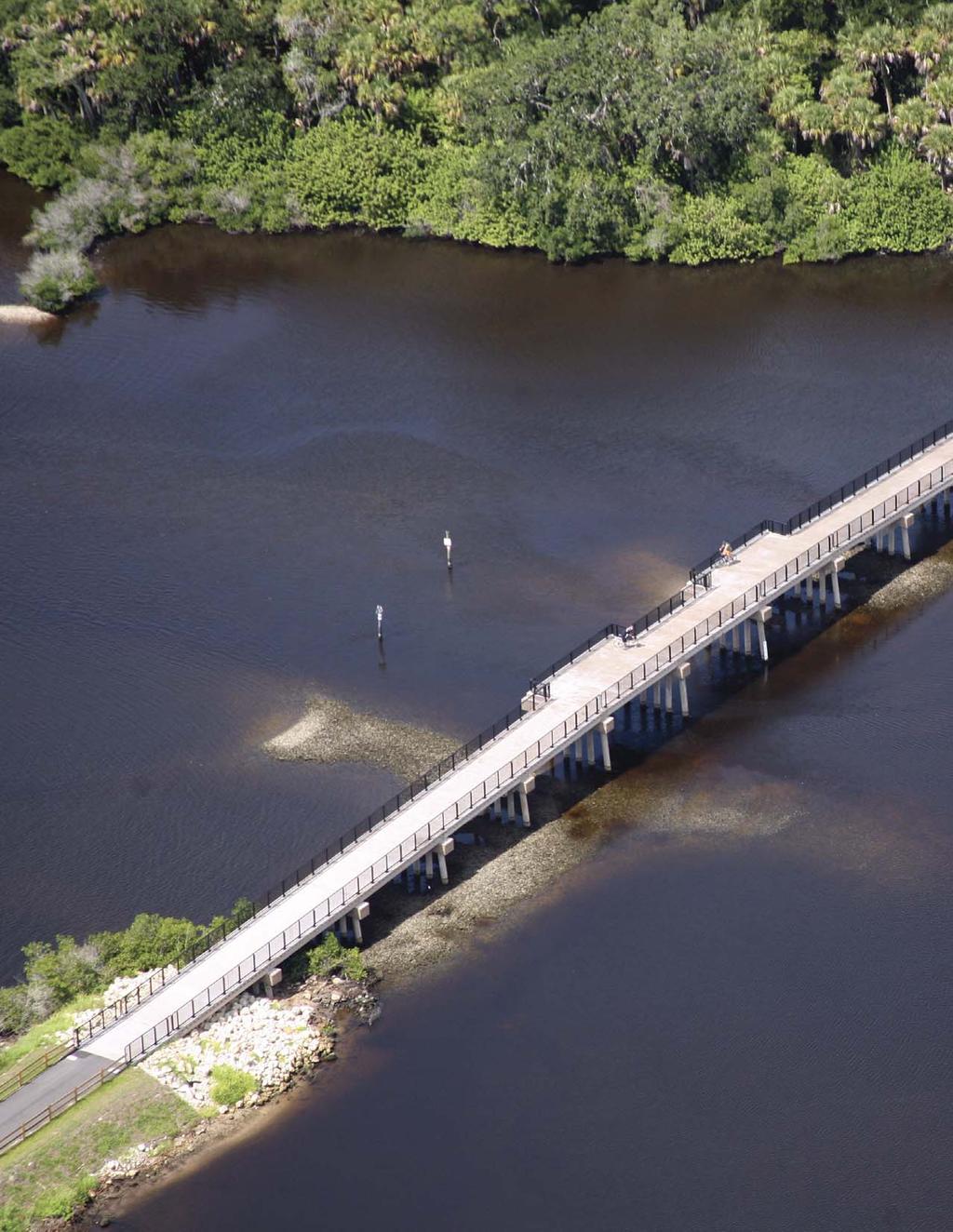
2 Artistic bridges complete missing link in high-profile Rails-to-Trails project By Kate Boupha S tep, roll, or ride onto the Legacy Trail in Sarasota County, Florida, on any weekend morning, and the popularity of the new bridges over Roberts Bay and Dona Bay is obvious. The Legacy Trail stretches 10.6 miles from south Sarasota into Venice and Nokomis. Just a few years ago, instead of the paved recreational gem it is now, the corridor was part of an overgrown, underused railroad. Through a partnership with the Trust for Public Lands, Sarasota County purchased the former CSX railroad in 2004, and it soon became one of Florida s 35 Rails-to-Trails projects, a national initiative to transform unused railroads to multiuse recreational trails. Beyond its natural environmental appeal, this corridor has historic character. The railroad preceded many highways and was once the main passage into Southwest Florida. Later, it was used by the U.S. Army during World War II, the Kentucky Military Institute, and the Ringling Bros. and Barnum & Bailey Circus, which has strong ties to history and development of the area. The restored Venice Train Depot preserves some of this history and serves as a trailhead to the Legacy Trail. Trail users had to wait until July 2010 for access to what is arguably the most significant natural attraction of the Legacy Trail Roberts Bay and Dona Bay. The sensitive estuarine environment is home to oysters, mangroves, manatees, sea turtles, and other wildlife. Before the bridges were built, the trail was interrupted abruptly with barricades to keep people off the unsafe, badly dilapidated train trestles over the water. To get back on the trail, they had to detour around Nokomis. We started with paving the trail between the bridges, which did provide some amenities and connectivity to the parks, said Alex Boudreau, PE, Sarasota County s construction manager for the project. But obviously the bridges were needed, and the community s support was really behind this project. Sarasota County retained Ayres Associates to design the new bridges over Roberts Bay and Dona Bay to connect these missing links in the Legacy Trail. The original railroad trestles were evaluated for rehabilitation but were not TRENDS 11
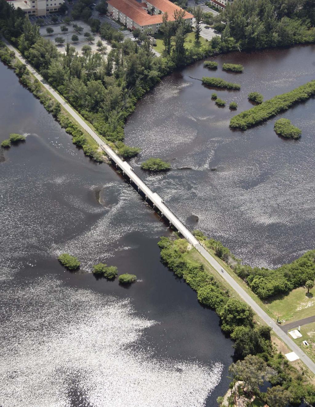
3 12 TRENDS

4 salvageable. The County wanted the design of the new structures to maintain the original character of the railroad trestles. The way to do that is through unique design details, said Hisham Sunna, PhD, PE, principal-in-charge for Ayres Associates. The aesthetic details are what connect the new bridges to the history and the location, he said. Designers came up with several key details to help make the pedestrian trail bridges look more like the old railroad trestles, starting with the pilings that support the structures. The pilings are unique in their shape, color, and placement. Designers chose 16-inch round piles rather than more typical piles like 24-inch square. The concrete itself was dyed to look older and darker more like the old railroad bridge. Because some of the characteristics of this structure are completely unique, it was challenging to find a fabricator that was willing and able to create them, said Steven Laney, PE, Ayres Associates supervisor of structural engineering. An added benefit of the dyed concrete is that it would require less maintenance without the need for repainting, he said. The number and spacing of the bridge supports were also purposely designed to mimic the old railroad structure. While today s typical trail bridge may have only two pilings in each bent, the Roberts and Dona Bay bridges have five to seven pilings that were placed similarly to the old railroad bridges. Perhaps the most striking feature is the look of railroad ties along the profiles of the bridges. The contractor and the fabricator built a concrete form that would essentially stamp an indentation at regular intervals and recreate the look of the ties, Laney said. The new bridges are better for the water quality and habitat in this delicate area. The old trestles were creosote-soaked lumber, and removing them was the best thing that could ve happened environmentally, Boudreau said. Creosote is a wood preservative that may have harmful health and environmental impacts. TRENDS 13


5 The bridges were raised to create a higher navigational clearance, and there is more space between the piles, so water should flow easier in and out of the bays. We used the same environmental footprint that was there before; it s just a little higher, Boudreau said, and without the creosote. Sarasota County needed to coordinate with several permitting agencies because of the intercoastal environment. Ayres Associates kept us in line with our permits, making sure we didn t step outside our bounds, Boudreau said. One way this was accomplished was through the swales, or ditches, at either side of the approaches to each bridge. The swales were designed to collect the water runoff from the bridges and treat the water before it was discharged back into the bays. Getting those right was probably one of our biggest concerns, Boudreau said. The design of these bridges had overwhelming community support, but that public backing also brought pressure to Ayres Associates to get it right and get the design done quickly. There was a lot of demand for these bridges because they were the missing link, Sunna said. Boudreau s job was to make sure any issues in the field were resolved quickly. Steve Laney s response always came in on time, and he worked with us to get what we needed, he said. The contractor, Misner Marine, kept the project on schedule and took steps to minimize the effect of construction on the sensitive ecosystem of the bays. The success is shared by everyone involved the engineer, county staff, the County Commission, the contractor, and the public. It took everyone s input, Boudreau said. Perhaps the greatest benefit of the bridges is the access they provide to a diverse range of users. Whether it is parents teaching children to ride a bike, athletes training for an upcoming race, or a nature enthusiast simply enjoying a sunset, the Legacy Trail is an ideal place on foot, tricycle, or wheelchair and right over the water. The project has brought a renewed sense of community and pride in local neighborhoods. The bridges really do capture the essence of the old trestles as realistically as you can while meeting today s structural, environmental, and safety standards, Boudreau said. I think they re going to look like they do today for a long, long time. 14 TRENDS
Tallahassee-St. Marks Historic Railroad Trail
 Revitalizing a Historic Trail Designated as a National Recreation Trail, the 16-mile Tallahassee-St. Marks Historic Railroad Trail has been enjoyed by countless bicyclists, runners, and outdoor enthusiasts
FEASIBILITY CRITERIA
 This chapter describes the methodology and criteria used to evaluate the feasibility of developing trails throughout the study areas. Land availability, habitat sensitivity, roadway crossings and on-street
Citrus Heights Creek Corridor Trail Project Trail Advisory Group Field Trip #2 September 11, :00 11:00 am Trellis Hall, Citrus Heights
 September 11, 2013 9:00 11:00 am Trellis Hall, Citrus Heights Project Overview The City of Citrus Heights is studying the feasibility of establishing a multi use trail system within the City s 26 miles
Appendix 3. Greenway Design Standards. The Whitemarsh Township Greenway Plan
 Appendix 3 Greenway Design Standards This chapter discusses two design standards for the greenway types discussed above. First, trail design standards are presented together with trailhead facilities and
ON THE RANCH NEWSLETTER OCTOBER 5, 2018
 ON THE RANCH NEWSLETTER OCTOBER 5, 2018 WWW.PALMERRANCH.NET News You Can Use 37 TH ANNUAL NATIONAL FALLEN FIREFIGHTERS DAY Flags on Palmer Ranch will be flown at half-staff from sunrise to sunset on Sunday,
HardisonInk.com Historic circus train cars park in eastern Levy County
 Historic circus train cars park in eastern Levy County Daryl Kirby and his wife Tracy Kirby talk to visitors as a Ringling Bros. and Barnum & Bailey Circus car is lifted off of the rail tracks for placement
Header i
 Header i 048285014.10 Header Sub Title Body Text here. Body text here. Body text here. Section 1... 1 Executive Summary... 1 Opportunities and Constraints... 3 Overall Opportunities and Constraints Map
PRESENTED TO Town of Middlebury, VT. PRESENTED BY VTrans, VHB, Fitzgerald & Halliday, Inc., and Kubricky Construction
 PRESENTED TO Town of Middlebury, VT PRESENTED BY VTrans, VHB, Fitzgerald & Halliday, Inc., and Kubricky Construction Meeting with you today Brian Carpenter, Middlebury Selectboard Chair Jim Gish, Middlebury
NPS Form a OMB No (8-86) Expires
 Expires") Section: F Page 247 Railroads in Minnesota, 1862-1956 Figures Railroad Roadway Edge of Right of Way Edge of Right of Way Railroad Bed Figure 1. Railroad Corridor, Young America vicinity, ca. 1915 Section:
Section: F Page 247 Railroads in Minnesota, 1862-1956 Figures Railroad Roadway Edge of Right of Way Edge of Right of Way Railroad Bed Figure 1. Railroad Corridor, Young America vicinity, ca. 1915 Section:
Appendix L Technical Memorandum Aesthetics
 Technical Memorandum Aesthetics 1.0 AESTHETICS This section provides a discussion of the aesthetic resources in the vicinity of ARTIC. Aesthetics pertain to the elements that make a certain view pleasing
CHAPTER ONE LITERATURE REVIEW
 CHAPTER ONE LITERATURE REVIEW LITERATURE REVIEW This chapter summarizes the most recently published community impact studies and articles that relate to multiuse trails. The review focuses on publications
Preliminary Findings of Proposed Alternative
 Preliminary Findings of Proposed Alternative The attached drawing provides a schematic layout of the proposed alternative that will be discussed on July 27, 2010. A full report will follow and should be
Public Notice ISSUED: December 10, 2018 EXPIRES: January 9, 2019
 APPLICANT: REFER TO: St. Louis and Lake Counties Regional Rail Authority 2018-01942-ARC Public Notice ISSUED: December 10, 2018 EXPIRES: January 9, 2019 SECTION:404 - Clean Water Act 1. APPLICATION FOR
Welcome to the future of Terwillegar Park a Unique Natural Park
 Welcome to the future of Terwillegar Park a Unique Natural Park 1 Introduction The Terwillegar Park Concept Plan study will develop an overall concept plan, management objectives and development guidelines
AGENDA ITEM 5 D WAKULLA ENVIRONMENTAL INSTITUTE (WEI) TRAIL FEASIBILITY STUDY
 TRAIL FEASIBILITY STUDY") March 19, 2018 AGENDA ITEM 5 D WAKULLA ENVIRONMENTAL INSTITUTE (WEI) TRAIL FEASIBILITY STUDY TYPE OF ITEM: Action STATEMENT OF ISSUE The Wakulla Environmental Institute (WEI) Trail is one of several trails
March 19, 2018 AGENDA ITEM 5 D WAKULLA ENVIRONMENTAL INSTITUTE (WEI) TRAIL FEASIBILITY STUDY TYPE OF ITEM: Action STATEMENT OF ISSUE The Wakulla Environmental Institute (WEI) Trail is one of several trails
Figure 1: Little Dry Creek Trail Crossing
 Figure 1: Little Dry Creek Trail Crossing Figure 2: Little Dry Creek Trail Crossing Northwest Rail Environmental Evaluation Temporary Trail Detour Concurrence Form Adams County, Little Dry Creek Trail
A CASE FOR COMPLETING THE JORDAN RIVER PARKWAY: A
 A CASE FOR COMPLETING THE JORDAN RIVER PARKWAY: A safe crossing at 9000 South and 850 West Proposed 9000 South Underpass Parkway Timeline Parkway, Trail, and Tourism Facts Blueprint Jordan River 1971 1973
MPRB: Southwest LRT Community Advisory Committee Issues and Outcomes by Location Current to: 12 November 2010
 MPRB: Southwest LRT Community Advisory Committee Issues and Outcomes by Location Current to: 12 November 2010 This is a compilation of issues and outcomes identified by the CAC. It is a work in progress,
The Baker/Carver Regional Trail is intended to
 Section V Design Guidance The Baker/Carver Regional Trail is intended to safely accommodate 183,000 annual visits, an array of non-motorized uses, a variety of skill levels, and persons with special needs.
2. Goals and Policies. The following are the adopted Parks and Trails Goals for Stillwater Township:
 D. PARKS AND TRAILS 1. Introduction Stillwater Township s population is relatively low, with most residents living on rural residences on large lots. The need for active park space has been minimal in
Airport Planning Area
 PLANNING AREA POLICIES l AIRPORT Airport Planning Area LOCATION AND CONTEXT The Airport Planning Area ( Airport area ) is a key part of Boise s economy and transportation network; it features a multi-purpose
The Chu property is a 6.57 acre parcel located in the Town of Superior on the west side of McCaslin Boulevard. In 2014, the Town of Superior acquired
 1 The Chu property is a 6.57 acre parcel located in the Town of Superior on the west side of McCaslin Boulevard. In 2014, the Town of Superior acquired the Chu property for open space with a contribution
4.0 Context for the Crossing Project
 4.0 Context for the Crossing Project This section provides background information about key features of the North Douglas Crossing project area, and opportunities and constraints. This information is important
Greenways Commission Meeting Agenda Monday, March 20, 2017; 4:00 pm 7:00 pm Town Hall, Parking Lot
 Greenways Commission Meeting Agenda Monday, March 20, 2017; 4:00 pm 7:00 pm Town Hall, Parking Lot I. 4:00 4:05 pm Leave Town Hall Parking Lot for Briar Chapel II. III. IV. 4:30 pm Site Visit - Briar Chapel
Mason Street Bike/Pedestrian Trail Project
 Construction of the much-anticipated Mason Trail is underway! Mountain Constructors was awarded the contract in September but had to go through a 2- month process to obtain construction clearance permits
$866,000. $1,400,000 Health Benefits $13,156,000 TOTAL ANNUAL DIRECT BENEFITS. $10,890,000 Economic Benefits
 SINGING RIVER TRAIL Trails Create Value + Generate Economic Activity Trails generate economic returns through improved health, safety, and environmental conditions, raise property values, and attract visitors.
METROPOLITAN COUNCIL 390 North Robert Street, St. Paul, MN Phone (651) TDD (651)
 TDD (651)") METROPOLITAN COUNCIL 390 North Robert Street, St. Paul, MN 55101 Phone (651) 602 1000 TDD (651) 291 0904 DATE: June 19, 2007 TO: Metropolitan Parks and Open Space Commission FROM: Jan Youngquist, Senior
METROPOLITAN COUNCIL 390 North Robert Street, St. Paul, MN 55101 Phone (651) 602 1000 TDD (651) 291 0904 DATE: June 19, 2007 TO: Metropolitan Parks and Open Space Commission FROM: Jan Youngquist, Senior
Wilds. Headwaters. Lakes. Oxbows. Falls
 56 5 4 3 Wilds Headwaters Lakes Oxbows Falls 57 Zones It could be said the on-the-ground essence of this master plan appears within the next 6 pages of this report. As we learned in the preceding Cultural
Agenda Report. Spruce Street Outlet Drainage Improvements Tower Road Relief Sewer
 Agenda Report Subject: Prepared By: Spruce Street Outlet Drainage Improvements Tower Road Relief Sewer Steven M. Saunders, Director of Public Works/Village Engineer Date: August 12, 2012 On March 8, 2012
Kit Carson-Challenger Ridge Trail Project Annual Performance Report-2014 October 22, 2014
 1 Kit Carson-Challenger Ridge Trail Project Annual Performance Report-2014 October 22, 2014 Willow Lake and Kit Carson Peak 2 SUMMARY The Rocky Mountain Field Institute began Phase 1 of a multi-phase,
Waukee Trailhead Public Art and Amenities Project
 Waukee - Trailhead Public Art and Amenities Project Sponsor Waukee Project Title Waukee Trailhead Public Art and Amenities Project Termini Description ( i.e. Park Avenue to 19th Street) NE Intersection
PIONEER PARK. City of Des Peres Parks Master Plan. SWT Design 46 INTRODUCTION
 PIONEER PARK INTRODUCTION Pioneer Park is a 7 acre neighborhood park located east of Interstate 270 and south of Manchester Road along Tallie Road. The park is situated in a residential neighborhood with
Criteria Based System for MPRB Regional Park and Trail Capital Project Scheduling
 Criteria Based System for MPRB Regional Park and Trail Capital Project Scheduling July 19, 2017 Background Beginning with the 2017-2022 Capital Improvement Program (CIP), MPRB used equity-driven metrics
City of Durango 5.8 FUNDING TRAILS DEVELOPMENT
 5.8 FUNDING TRAILS DEVELOPMENT The City has been successful in establishing dedicated local funding sources as well as applying for grants to develop the City s trail system, having received nearly $2.4
K SIGNAGE & TRAFFIC CONTROL. Table of Contents
 Table of Contents K1. ACCOMMODATION OF TRAFFIC... 1 K2. MINIMUM CONSTRUCTION SIGNING... 1 K3. SUBDIVISION SIGNS... 2 K4. TRAFFIC CONTROL DEVICES... 2 K4.1 Traffic Signs Regulations... 2 K4.2 Materials...
Chapter 6. Trail Design. Trail Design
 Chapter 6 Trail Design Trail Design The trail winds through a region rich in scenic beauty, cultural, and natural history. Volunteer landscape architects working with the Core and Planning Teams, have
WASHINGTON STATE PARKS AND RECREATION COMMISSION POLICY/PROCEDURE
 WASHINGTON STATE PARKS AND RECREATION COMMISSION POLICY/PROCEDURE 65-13-1 Use of Other Power-Driven Mobility Devices by Persons with Mobility Disabilities at State Park Facilities See Also: 28 CFR 35 Title
2016 Regional Transportation Alternatives Program (TAP) Grant Application
 Grant Application") 2016 Regional Transportation Alternatives Program (TAP) Grant Application PROJECT TITLE: Yelm-Tenino Trail Extension Feasibility Study TRPC use only GENERAL PROJECT INFORMATION Agency or Organization City
2016 Regional Transportation Alternatives Program (TAP) Grant Application PROJECT TITLE: Yelm-Tenino Trail Extension Feasibility Study TRPC use only GENERAL PROJECT INFORMATION Agency or Organization City
Welcome to the Cross County Trail Public Input Session!
 Welcome to the Cross County Trail Public Input Session! Please sign in on the table below! What are we doing here? Camden County has proposed a bicycle and pedestrian trail spanning across the entire county.
Kelly Motorized Trails Project Proposed Action
 Kelly Motorized Trails Project Proposed Action November 28, 2011 The Flagstaff Ranger District of the Coconino National Forest is seeking public input on the proposed Kelly Motorized Trails Project (formerly
Limestone Road Industrial Area Brandon Manitoba ~141 Acres Rail Accessible, Ready for Development
 Limestone Road Industrial Area Brandon Manitoba ~141 Acres Rail Accessible, Ready for Development Dan Fontaine Business Development Specialist 204.729.2133 or 1.866.729.2132 D.Fontaine@brandon.ca EconomicDevelopmentBrandon.com
ROAD AND TRAIL PROJECT APPROVAL
 ROAD AND TRAIL PROJECT APPROVAL www.marincountyparks.org Marin County Parks, 3501 Civic Center Dr, Suite 260, San Rafael, CA 94903 DATE: July 12, 2017 PRESERVE: Gary Giacomini Open Space Preserve PROJECT:
ADOPT-A-TRAIL MANUAL C. Bailey-May
 ADOPT-A-TRAIL MANUAL C. Bailey-May 2011 1 ADOPT-A-TRAIL VOLUNTEER DUTIES Welcome to the White Mountain National Forest s Adopt-A-Trail (AAT) program and thank you for volunteering with us! This volunteer
The following trails completed their work utilizing funds awarded by the Greenways Foundation:
 The Greenways Foundation Grant Awards 2013 and 2014 Our grant program has been in place since 2012 and is funded entirely by the proceeds received through our Indiana BMV specialty license plate. Please
Lake Apopka Trail Loop Design Guidelines
 November 2002 Prepared for 14908 Tilden Road Winter Garden, FL 34787 Prepared by 140 North Orlando Avenue Suite 295 Winter Park, FL 32789 November, 2002 I. INTRODUCTION...1 II. DESIGN GUIDELINES FOR TRAILS...3
Auburn Trail / Ontario Pathways Trail Connector Feasibility Study Public Information Meeting Wednesday, August 22, 2012
 Auburn Trail / Ontario Pathways Trail Connector Feasibility Study Public Information Meeting Wednesday, August 22, 2012 Purpose of Feasibility Study Purpose Evaluate the feasibility of constructing a multiuse
10/25/2013. What is the SCORP?! 2013 Local Government Survey 2013 Statewide Public Survey Advisory Group Priority Areas Your Suggestions!
 COLORADO OUTDOOR RECREATION TRENDS RESULTS FROM THE SCORP AND STATEWIDE Colorado Outdoor Recreation Resource Partnership September 2013 PRESENTATION What is the SCORP?! 2013 Local Government Survey 2013
Business Item No
 Metropolitan Parks and Open Space Commission Meeting date: February 6, 2018 For the Community Development Committee meeting of February 20, 2018 For the Metropolitan Council meeting of February 28, 2018
City Council Workshop July 26, 2010
 Des Moines Trails Connecting a Community City Council Workshop July 26, 2010 1 OVERVIEW Trail Benefits Trails Progress How We Fund Trails What s Next for Trails 2 What is a trail? Paved Trails 10 wide
If anyone would like to discuss either the questions, or the answers, with me, they are invited to contact me at
 Questionnaire 2017 Municipal Elections If anyone would like to discuss either the questions, or the answers, with me, they are invited to contact me at andrealockwoodchelsea2017@gmail.com. 1. Do you believe
This document is being shared by the Parks, Recreation and Musuem Advisory Board at the request of Golden citizens and in order to be transparent
 This document is being shared by the Parks, Recreation and Musuem Advisory Board at the request of Golden citizens and in order to be transparent about what documents and information was shared during
APPENDIX F List of Commitments
 APPENDIX F List of Commitments s Table F.1 Standard Mitigation Measures Mitigation Measure MnDOT Specification Number Status Update Description Status Update Utilities Provide early notice to utility operators
hudsonriverpark.org 2017 Brand Activation and Partnership Opportunities
 1 2017 Brand Activation and Partnership Opportunities 2 A World Class Park Background Hudson River Park is enjoyed annually by millions of New Yorkers and visitors from around the world. Since construction
MERRYMEETING TRAIL A&B. Topsham. Head of Tide Park Trail (Tedford Road to Cathance Road) Length: 1.79 Miles Anticipated Cost: $719,000.
 Length: 1.79 Miles Anticipated Cost: $719,000.") 1 MERRYMEETING TRIL Head of Tide Park Trail (Tedford Road to athance Road) Topsham Length: 1.79 Miles nticipated ost: $719,000 D athance Road athance Road Section 1 connects residential neighborhoods and
1 MERRYMEETING TRIL Head of Tide Park Trail (Tedford Road to athance Road) Topsham Length: 1.79 Miles nticipated ost: $719,000 D athance Road athance Road Section 1 connects residential neighborhoods and
NOTE: YOU MAY COMPLETE THIS SURVEY ONLINE (USING THIS DOCUMENT TO VIEW MAPS AND GRAPHICS) AT:
 AT:") for completing the Town of Beech Mountain Comprehensive Planning Survey. The information you provide in reply to the following questions will be used to help the Town develop a plan that will guide our
for completing the Town of Beech Mountain Comprehensive Planning Survey. The information you provide in reply to the following questions will be used to help the Town develop a plan that will guide our
CHAPTER 5. Chapter 5 Recreation Element
 CHAPTER 5 Recreation Element Chapter 5 Recreation Element The Recreation Element of the Meyers Area Plan is a supplement to the Recreation Element of the TRPA Regional Plan and the El Dorado County General
Attendance Presentation
 TO The Community of Saanich FROM District of Saanich DATE January 30, 2017 RE Meeting Notes Haro Woods Jan 28th Community Engagement Goward House, 2495 Arbutus Road, Victoria BC Attendance In total, 18
Welcome to Marco Island
 Marco Island is located in Southwest Florida, on the Gulf of Mexico, 178 miles south of Tampa,16 miles south of Naples, and 104 miles due west of Miami. Marco is the northern most and largest of the famous
Decision Memo Ice Age Trail Improvement (CRAC 37)
") Decision Memo Ice Age Trail Improvement (CRAC 37) U.S. Forest Service Chequamegon-Nicolet National Forest, Medford-Park Falls Ranger District Taylor County, Wisconsin T32N, R2W, Town of Grover, Section
Decision Memo Ice Age Trail Improvement (CRAC 37) U.S. Forest Service Chequamegon-Nicolet National Forest, Medford-Park Falls Ranger District Taylor County, Wisconsin T32N, R2W, Town of Grover, Section
Fair Park Comprehensive Development Plan Update. City Council Briefing November 5, 2007
 1 Fair Park Comprehensive Development Plan Update City Council Briefing November 5, 2007 Introduction Park and Recreation Department Renaissance Plan focused on eight Big Moves: Upgrade current parks Provide
The Atlanta BeltLine. & Sustainable Development GAFM Conferance. // March 25, 2014
 The Atlanta BeltLine & Sustainable Development GAFM Conferance // March 25, 2014 04/22/2014 Atlanta BeltLine // 2013 Page 1 // Organizational Structure Project Owner and Sponsor Redevelopment Authority
Cross Florida Beach to Beach Adventure Bicycle Route
 Cross Florida Beach to Beach Adventure Bicycle Route 240 Miles from Juno Beach to Venice Beach This document can be viewed and downloaded from the Cross Florida Adventure Bicycle Route tab at www.bikeveniceflorida.com
Bridging Belmont. By ROGER AMSDEN, LACONIA DAILY SUN
 Bridging Belmont This covered bridge was bought for $1 in 2013 from Dover, and broken into three sections. One section was installed two years ago, and the second and third sections were combined for a
Proposed Action. Payette National Forest Over-Snow Grooming in Valley, Adams and Idaho Counties. United States Department of Agriculture
 United States Department of Agriculture Forest Service January 2012 Proposed Action Payette National Forest Over-Snow Grooming in Valley, Adams and Idaho Counties Payette National Forest Valley, Adams
Map 1.1 Wenatchee Watershed Land Ownership
 Map 1.1 Wenatchee Watershed Land Ownership Map 1.1 Wenatchee Watershed Land Ownership The Wenatchee watershed lies in the heart of Washington state in Chelan County. Just larger than the state of Rhode
Update on Trinity Trails. Presented by: Richard Zavala, Director Park and Recreation Department February 7, 2017
 Update on Trinity Trails Presented by: Richard Zavala, Director Park and Recreation Department February 7, 2017 Overview Provide review of trail planning and development along the main stem Trinity River
Daniel Mecklenburg 107 Old Wawbeek Road Tupper Lake, NY 12986
 December 2, 2015 NYS Adirondack Park Agency P.O. Box 99 1133 NYS Route 86 Ray Brook, NY 12977 Attention: Kathy Regan RE: Remsen-Lake Placid Travel Corridor Unit Management Plan -- proposed Alternative
Flow Stand Up Paddle Board Parkway Plan Analysis
 Regional Parks Department Jeffrey R. Leatherman, Director County of Sacramento Divisions Administration Golf Leisure Services Maintenance Rangers Therapeutic Recreation Services Flow Stand Up Paddle Board
Chapter 4.0 Alternatives Analysis
 Chapter 4.0 Alternatives Analysis Chapter 1 accumulated the baseline of existing airport data, Chapter 2 presented the outlook for the future in terms of operational activity, Chapter 3 defined the facilities
COASTAL CONSERVANCY. Staff Recommendation October 21, 2010 PETALUMA TRESTLE REHABILITATION DESIGN
 COASTAL CONSERVANCY Staff Recommendation October 21, 2010 PETALUMA TRESTLE REHABILITATION DESIGN Project No.: 10-017-01 Project Manager: Deborah Hirst RECOMMENDED ACTION: Authorization to disburse up to
Maryland Transit Administration. Master Plan Alignment Trail
 Maryland Transit Administration Master Plan Alignment Trail Master Plan Alignment Byrne Kelly Concept Trail Analysis - North vs. South Trail Access & Crossings Aesthetics Master Plan Alignment Description
NORTHWEST SECTION CONTENTS: CLEVELAND PARK FOLWELL PARK RYAN LAKE PARK VICTORY PRAIRIE DOG PARK VICTORY PARK
 NORTHWEST SECTION CONTENTS: CLEVELAND PARK FOLWELL PARK RYAN LAKE PARK VICTORY PRAIRIE DOG PARK VICTORY PARK LUCY LANEY COMMUNITY SCHOOL N 33RD AVE N 33RD AVE SINGLE-FAMILY RESIDENTIAL MULTI-USE DIAMOND
PLAN Anoka County - Blaine Airport
 Reliever Airports: NOISE ABATEMENT PLAN Anoka County - Blaine Airport INTRODUCTION The noise abatement plan for the Anoka County-Blaine Airport was prepared in recognition of the need to make the airport
Proposal to Redevelop Lower Kananaskis River-Barrier Lake. Bow Valley Provincial Park
 Frequently Asked Questions Proposal to Redevelop Lower Kananaskis River-Barrier Lake Bow Valley Provincial Park Frequently Asked Questions What has been decided? What are the details of the plan? What
Tourism and Conservation in Protected Areas
 Tourism and Conservation in Protected Areas ~ Putting words into action ~ Pamela A. Wright, Ph.D. Outdoor Recreation & Tourism Management University of Northern British Columbia Chair, BC Protected Area
Theme: Predominately natural/natural appearing; rustic improvements to protect resources. Size*: 2,500 + acres Infrastructure**:
 Recreation Opportunity Spectrum (ROS) Classes The Recreation Opportunity Spectrum (ROS) provides a way to describe the variations in the degree of isolation from the sounds and influences of people, and
Thank you for the opportunity to comment on the proposed action to add trails and trailheads to the Red Rock District trail system.
 July 14, 2010 Jennifer Burns Red Rock Ranger District PO Box 20429 Sedona, AZ 86341 Flagstaff Biking Organization PO Box 23851 Flagstaff, AZ 86002 Dear Jennifer- Thank you for the opportunity to comment
Trail Use in the N.C. Museum of Art Park:
 Trail Use in the N.C. Museum of Art Park: New Connections, New Visitors Jacqueline MacDonald Gibson, PhD Daniel Rodriguez, PhD Taylor Dennerlein, MSEE, MCRP, EIT Jill Mead, MPH Evan Comen University of
chapter - Hex Highway Touring Route Hamburg to Strausstown Overview
 chapter - 2 Hex Highway Touring Route Hamburg to Strausstown Overview The on-road Hex Highway automobile and bicycle touring route begins on State Street in downtown Hamburg. The route continues west on
Environmental Development of River Road Ranch
 Environmental Development of River Road Ranch New Braunfels, Texas Alix Scarborough GEO 3426 April 2012 Introduction The 2,400-acre Word-Borcher ranch has been owned by the Word family since 1941. Located
Railroad Safety Trail
 2.1 INTRODUCTION AND PROJECT SETTING 2.1 Introduction & Project Setting Introduction This study is the result of a directed effort on the part of the City of San Luis Obispo to carry out previously established
Understanding user expectations And planning for long term sustainability 1
 Understanding user expectations And planning for long term sustainability 1 What is a natural surface trail? It can be as simple has a mineral soil, mulched or graveled pathway, or as developed as elevated
SR 934 Project Development And Environment (PD&E) Study
 Study") SR 934 Project Development And Environment (PD&E) Study Project Advisory Group Meeting March 1, 2018 State Road 934/NE/NW 79th Street from west of I-95 (NW 13th CT) to N. Bayshore Drive PD&E STUDY SR 934/NE/NW
SR 934 Project Development And Environment (PD&E) Study Project Advisory Group Meeting March 1, 2018 State Road 934/NE/NW 79th Street from west of I-95 (NW 13th CT) to N. Bayshore Drive PD&E STUDY SR 934/NE/NW
Uniclass L534+L212. August home zones. paving PRECAST CONCRETE PAVING SOLUTIONS FOR TODAY S RESIDENTIAL STREET ENVIRONMENTS.
 August 2005 Uniclass L534+L212 paving home zones PRECAST CONCRETE PAVING SOLUTIONS FOR TODAY S RESIDENTIAL STREET ENVIRONMENTS www.paving.org.uk Home Zone Principles Home Zones are residential streets
To: Mary Beth Avedesian B.F. Saul Company
 1140 Connecticut Avenue NW Suite 600 Washington, DC 20036 202.296.8625 TECHNICAL MEMORANDUM To: Mary Beth Avedesian B.F. Saul Company From: Daniel B. VanPelt, P.E., PTOE Felice B. Brychta, P.E. Tricia
FDOT Treasure Coast Traffic Impact Report June 19 through June 26, 2015
 June 19, 2015 Chuck McGinness, 954-777-4302 chuck.mcginness@dot.state.fl.us FDOT Treasure Coast Traffic Impact Report June 19 through June 26, 2015 TREASURE COAST Construction and maintenance-related lane
Atlantic Street Bridge Project Update CTDOT Project Nos & (Phase 2)
") Atlantic Street Bridge Project Update CTDOT Project Nos. 135-301 & 301-163 (Phase 2) Reconstruction of Atlantic Street & Metro-North RR Bridge Replacement Track & Station Infrastructure Improvements City
Atlantic Street Bridge Project Update CTDOT Project Nos. 135-301 & 301-163 (Phase 2) Reconstruction of Atlantic Street & Metro-North RR Bridge Replacement Track & Station Infrastructure Improvements City
THAT the Board approve the final proposed concept plan for the Jericho Marginal Wharf site as shown in Figure C-4 of Appendix C.
 Date: January 17, 2012 TO: Board Members Vancouver Park Board FROM: General Manager Parks and Recreation SUBJECT: Jericho Marginal Wharf Phase 2 Concept Plan RECOMMENDATION THAT the Board approve the final
River Parks Trail: Tulsa, Oklahoma
 River Parks Trail: Tulsa, Oklahoma Purpose: The purpose of the River Parks Trail is to maintain, preserve, develop, and promote the Arkansas River for the economic and cultural benefit of the community.
APPENDIX B LAND MANAGER SURVEY
 APPENDIX B LAND MANAGER SURVEY #1 COMPLETE Collector: Web Link 1 (Web Link) Started: Tuesday, March 20, 2018 11:39:32 AM Last Modified: Tuesday, March 20, 2018 12:05:50 PM Time Spent: 00:26:18 IP Address:
Logo Department Name Agency Organization Organization Address Information 5700 North Sabino Canyon Road
 Logo Department Name Agency Organization Organization Address Information United States Forest Coronado National Forest 5700 North Sabino Canyon Road Department of Service Santa Catalina Ranger District
Proposal to Redevelop Lower Kananaskis River-Barrier Lake. Bow Valley Provincial Park. Frequently Asked Questions
 Proposal to Redevelop Lower Kananaskis River-Barrier Lake Bow Valley Provincial Park Frequently Asked Questions What is being proposed? What are the details of the proposal? Where is the project area located?
Adopt a Trail Blue Ridge Parkway
 Adopt a Trail Blue Ridge Parkway THANK YOU Thank You for volunteering to maintain a trail with the Adopt-A-Trail program! You are helping to keep these trails open for public use and enjoyment. We couldn
railroad tracks. In 1932
 238 W. Tampa Avenue: Originally San Marco Hotel This three-story, steel-reinforced, concrete block, stuccoed building was commissioned by the Brotherhood of Locomotive Engineers (BLE) as a 92 room hotel
FDOT Treasure Coast Traffic Report through
 FDOT Treasure Coast Traffic Report 02 26 16 through 03 04 16 Kathleen Dempsey Fri 2/26/2016 2:56 PM To:Kathleen Dempsey ; 1 attachment 355 KB CR 714_Median Access Modifications.pdf;
County of Sonoma Agenda Item Summary Report
 Revision No. 20170501-1 of Sonoma Agenda Item Summary Report Agenda Item Number: 37 (This Section for use by Clerk of the Board Only.) Clerk of the Board 575 Administration Drive Santa Rosa, CA 95403 To:
Outdoor Patio Buyer's Checklist
 Outdoor Patio Buyer's Checklist What You Need to Know www.galaxyhomerecreation.com Tulsa Oklahoma City Broken Arrow As the weather begins to warm, spending time outdoors entertaining, relaxing and enjoying
Survey Summary. 1. Overview. Pilot Implementation Survey Toronto Parks & Trails Wayfinding Strategy (Phase II) September 30 November 6, 2017
 September 30 November 6, 2017") Survey Summary Pilot Implementation Survey Toronto Parks & Trails Wayfinding Strategy (Phase II) September 30 November 6, 2017 1. Overview Between September 30 and November 6, 2017, the City of Toronto
Survey Summary Pilot Implementation Survey Toronto Parks & Trails Wayfinding Strategy (Phase II) September 30 November 6, 2017 1. Overview Between September 30 and November 6, 2017, the City of Toronto
Each picture below has a brief explanation of the alignment. Please review and feel free to send any questions you might have.
 TO: Golden Parks, Recreation and Museums Advisory Board FR: Al Head & Ben Davis, Golden Giddyup Tim Waters & Jerry Harcek, Golden Community Members RE: Singletrack Sidewalks Pilot Proposal 3.0, January,
Welcome. Great Yarmouth Third River Crossing. Norfolk County Council
 Welcome Great Yarmouth Third River Crossing We are proposing to build a new bridge between Harfreys Roundabout and South Denes Road, and we would like your views. This consultation is stage two of a three-stage