Exploring North Dakota s National Treasures
|
|
|
- Kerry Green
- 5 years ago
- Views:
Transcription


1 National Parks of North Dakota National Park Service U.S. Department of the Interior Visitor Guide The official newspaper of Theodore Roosevelt National Park, Fort Union Trading Post National Historic Site, and Knife River Indian Villages National Historic Site Summer Winter 2013 Little Missouri River, Theodore Roosevelt NP Exploring North Dakota s National Treasures THERE ARE THREE NATIONAL PARK SERVICE SITES IN North Dakota. They are Theodore Roosevelt National Park in western North Dakota, Fort Union Trading Post National Historic Site in far north-western North Dakota, and Knife River Indian Villages National Historic Site in central North Dakota. Each is a unique experience; each protects and preserves a different aspect of American natural and cultural history; and each is an adventure to remember. Theodore Roosevelt National Park COMPRISED OF THREE UNITS: THE NORTH UNIT, the, and the Elkhorn Ranch Unit, Theodore Roosevelt National Park stretches across 70,416 acres of western North Dakota. Preserving an area of land that profoundly affected President Theodore Roosevelt, this park is a mecca for nature lovers and outdoor enthusiasts. Abundant wildlife, scenic drives, and miles of trails await your arrival. Turn to page 2 to learn more! Fort Union Trading Post NHS NOT YOUR STANDARD FORT - FORT UNION TRADING Post National Historic Site is a must for anyone with an interest in Early American History. Not a government or military post, but built for trade, the Fort has seen the likes of George Catlin, Karl Bodmer, John James Audubon, and Prince Maximilian. Great tribal leaders from many of the nations that traded here also graced this Fort. Come for a visit and walk in their footsteps. Special events throughout the year help make history come alive. Turn to page 10 to learn more! Knife River Indian Villages NHS IS LOCATED ON THE KNIFE RIVER DIRECTLY NORTH of its confluence with the Missouri River. Earthlodge people hunted bison and other game, but were in essence farmers living in villages along the Missouri and its tributaries. The site was a major American Indian trade center for hundreds of years prior to becoming an important marketplace for fur traders after Today, visitors can see the archeological remains of earthlodge villages and experience the landscape where Lewis and Clark met Sakakawea on their journey west. Turn to page 11 to learn more! Top Image: Rendezvous at Fort Union Trading Post National Historic Site Bottom Image: Reconstructed Earthlodge at Knife River Indian Villages National Historic Site Welcome to the North Dakota National Parks Whether you are seeking to encounter a piece of American history, take a glimpse into the life of a former president, or enjoy wildlife in their natural habitat, the North Dakota National Parks have something for you. Theodore Roosevelt National Park, Fort Union Trading Post National Historic Site and Knife River Indian Villages National Historic Site each provide opportunities to experience important chapters of the American story. The vast North Dakota prairies, rivers, and badlands are home to a wide variety of native wildlife such as bison, elk, bighorn sheep, bald and golden eagles, meadowlarks, burrowing owls, and prairie dogs. They have provided food, clothing, shelter, and a way of life to American Indian tribes for generations. They have been the land of opportunity for trappers and traders, homesteaders and ranchers, and a source of inspiration for a future president. And they offer you the chance to savor the outdoors, find solitude, take some time with your family, or make your own connections with your national parks. National Parks more than 397 units throughout the United States and its territories have been set aside to preserve and protect the many aspects of our natural and cultural heritage. They tell the story of us as Americans. While doing so, they are also managed for us and future generations - to enjoy. They are here for all of us, and they belong to you. Welcome! Valerie Naylor Superintendent Elkhorn Ranch 4 Petrified Forest 4 Hiking Trails 8 Plan Your Visit to TRNP 2-3 The Elkhorn & Petrified Forest 4 Getting to the Elkhorn 5 TRNP North and Maps 6-7 TRNP Hiking Guide 8 Junior Ranger Activities 9 Fort Union NHS 10 Knife River Indian Villages NHS 11 TRNHA & Area Map 12 The Elkhorn was the home ranch of Theodore Roosevelt while he cowboyed in the Dakota Badlands. It was here, Roosevelt said, that...the romance of my life began. Although the home no longer stands, the site of the ranch house is protected and available for visitors to enjoy today just as Theodore Roosevelt did in the 1880s. Take a trip out and see why this area had such a profound impact on a future U.S. President. Turn to page 4 to learn more! Wander through the remains of an ancient forest. Remote and protected, this is the third most important collection of petrified wood in North America. Just a short visit here can offer insight into the past, instill wonder, inspire questions, and spark a desire to learn more about the geologic forces still at work in the badlands. A 45 minute drive and a 3 mile hike are all that is required for this incredible journey. Turn to page 4 to learn more! With over 95 miles of trails in TRNP, there is plenty of opportunity to get out and truly explore the North Dakota Badlands. Detailed hiking maps and descriptions will help you choose the right adventure for you. For your safety, be sure you and someone not with you knows where you are going and how long you plan to be out. Hike prepared. Always carry water and a hat. Maps are found on pages 6 & 7. The hiking guide is located on page 8.
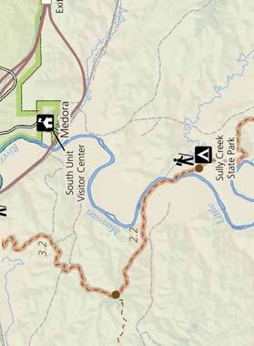
2 Theodore Roosevelt National Park Superintendent Valerie Naylor Mailing Address Theodore Roosevelt National Park P.O. Box nd Avenue Medora, North Dakota Park Information & Lost and Found Website Find us on Facebook and Twitter Fax Number National Park Service U.S. Department of the Interior EMERGENCY Dial 911 or contact a uniformed employee KNOW THE LAW Did you know it is illegal to collect items inside a National Park, including wildflowers, antlers, & rocks? Rules may be different here than what you are used to. It is your responsibility to know the law. If you have a question, ask! Or visit our website and read the Superintendent s Compendium & Title 36 of the Code of Federal Regulations. Find them at by clicking on Management and then Laws and Policies. What Can Get Me Hurt? Welcome to Theodore Roosevelt National Park. The vastness and wildness of this place will undoubtably add to your adventure, however this may also create unfamiliar challenges that you are not expecting. It is important to plan carefully for your stay. Park Rangers at the visitor centers can provide planning information and weather forecasts, but your safety ultimately depends on your own good judgement, adequate preparation, and awareness. DRIVING Park roads are used by vehicles, bicyclists, and walkers, as well as our abundant wildlife. Roads are narrow with steep hills and blind curves. Obey posted speed limits. In most areas of the park, the posted speed is 25 MPH. Per federal law, seatbelts are required for all occupants in a vehicle while driving in the park. For your safety, do not stop or park on the road. Other drivers are not expecting a stopped car and may not be able to see you. Pull off of the roadway when stopping to view wildlife. To protect park resources, please turn off your vehicle when parked. Don t drink and drive. For your safety, Park Rangers enforce laws against alcohol and drug-related driving offenses, including open container violations. HEAT & DEHYDRATION The prairie environment can be deceiving. It is often hotter and more exposed than expected. Shade is hard to come by. Dehydration and heat exhaustion are common dangers that can be avoided with adequate preparation. Carry and drink water: at least 2 quarts per person for a half-day hike. Wear a hat. Know where you are going and how long you plan to be out. Do not expect to find water in the backcountry. Much of the year, water is scarce. Never drink untreated water. BENTONITE CLAY Rain may be scarce, however when precipitation does come, it can cause horrific mud. The mud in the North Dakota Badlands has been known to turn a day hike into a trudge for survival, fatally trap horses on trail rides, and sink the tires of more than one vehicle. When wet, clay particles swell to several times their original size, causing the clay to become extremely sticky and slick. Mudslides are common. Mud may look dry on top while it is wet underneath. Be careful where you lead your horse. Be aware of the forecast when heading out for a hike or ride. THUNDERSTORMS Lightning kills more people each year than any other weather event. On the Great Plains, severe thunderstorms are a common summer experience. While in the park, keep an eye to the sky. If thunderheads begin to develop, consider moving toward shelter. Do not seek shelter from lightning under an overhang, tree, or other open shelter. Get inside something a building or vehicle. If shelter is unavailable, crouch down in a low area. In the case of a tornado, the best shelter is inside a sturdy building, away from windows. If a building is not available, lie down in a ditch or low area and cover your head to protect yourself against flying debris. When choosing a low-lying area for shelter from lightning or tornado, be sure to look around for evidence of past flash floods. Heavy rains often accompany severe thunderstorms. Hours of Operation November 12 March 31 Painted Canyon April 1 November 11 Painted Canyon Fri. Sun. 9:00 am 5:30 pm, CT Daily, 8:00 am 4:30 pm, MT Closed for the Season Daily, 9:00 am 5:30 pm, CT Daily, 8:00 am 4:30 pm, MT Daily, 8:30 am 4:30 pm, MT June early September hours are further extended. s are closed Thanksgiving Day, Christmas Day, and New Year s Day. The park is open 24 hours a day, 365 days a year. The operates on Central Time. The operates on Mountain Time. Fees Fees: $10 per vehicle (including motorcycles); $5 per individual: pedestrian, bicycle, or horseback. Entrance fees are valid for seven days. Commercial groups: Inquire at the entrance stations or visitor centers. Annual Passes are available. Plan Your Visit INFORMATION Park Rangers and s are excellent sources of information. The is located at the entrance off of Hwy 85. The has two visitor centers: Painted Canyon at exit 32 on I-94 and the Visitor Center at the entrance to the park in Medora, ND. PETS Pets are allowed along park roads, in picnic areas, and in campgrounds if they are under control and on leashes not longer than 6 feet. Pets are not allowed on trails, in TRNP ANNUAL PASS $20 Admission to this National Park for one year from date of purchase. ANNUAL PASS $80 Admission to all federal fee areas for one year from date of purchase. buildings, or in the backcountry. You must clean up after your pet. RESTROOMS Restrooms can be found at the visitor centers, campgrounds, and picnic areas. There are NO RESTROOMS available along the scenic drives. Please plan accordingly. In case of an emergency, practice Leave No Trace principles: bury human waste six inches deep and dispose of toilet paper properly. Leaving toilet paper behind is considered littering and could result in a $100 fine. Please do your part to keep the park beautiful! SENIOR PASS $10 Admission to all federal fee areas for life, U.S. residents 62 years or older. ACCESS PASS FREE Admission to all federal fee areas for life, permanently disabled U.S. residents. Passes are available at park entrance stations. Information about interagency passes and participating agencies (NPS, BLM, FWS, USFS, and BOR) is available online at store.usgs.gov/pass. TELEPHONES Your cell phone may not work in the park. Telephones are available for public use at the campgrounds,, and seasonally at Painted Canyon. Calling cards are required for long-distance calls. ACCESSIBILITY The park s buildings, picnic areas, and some trails are accessible. Service dogs are permitted on leashes throughout the park. The South Unit orientation film offers captioning, audio description, and assistive listening devices. Accessibility guides are available. Firearms Firearms are permitted in National Parks. As of February 22, 2010, federal law allows people who can legally possess firearms under federal, North Dakota, and local laws, to possess firearms in a National Park area. It is the visitor s responsibility to understand and comply with all applicable North Dakota, local, and federal firearms laws. Federal law prohibits firearms in National Park buildings and certain facilities. 2 Visitor Guide


3 Recreation CAMPING Campgrounds have restrooms, drinking water, picnic tables, and fire grates. There are no showers available within Theodore Roosevelt National Park. Shower facilities are limited in Medora and Watford City. The availability of these services varies seasonally. BACKCOUNTRY CAMPING Permits are required for all backcountry camping. Permits are free and available at park visitor centers. The maximum group size is 10 people without horses or 8 people with 8 horses. Backcountry regulations apply. FIRES When fire danger is high, campfires may be prohibited. At all other times, fires are only allowed in fire grates in the campgrounds and picnic areas. Fires are never permitted on the ground or in the backcountry. Collecting firewood is allowed in the campgrounds; the wood must be dead and down. Destruction or injury to standing trees is prohibited. Collecting wood outside of the campground is prohibited. Please do not bring wood in from other states or counties. Turn to page 9 to find out why. PICNIC AREA Shaded picnic areas are available adjacent to the campgrounds in both the North and s. These facilities have restrooms, picnic tables, and fire grates. They are available on a first come, first served basis. HORSEBACK RIDING Backcountry trails throughout the park are open to horseback riders. Stock are prohibited on nature trails and in all campgrounds except the Roundup Horse Camp. Boarding is available at Peaceful Valley Ranch. Guided rides are conducted from Peaceful Valley Ranch in the by a private concessionaire. They are offered daily from late May through early September. Ask at the visitor center for more information. BICYCLING Bicycles may travel only on developed roadways. They are not allowed off roadways or on trails, including the sections of the Maah Daah Hey Trail that lie within park boundaries. Remember, the rules of the road apply to bicycles. Please ride on the right side of the road in single file and wear your helmet. Campgrounds Juniper Campground - No Hookups Cottonwood Campground - No Hookups Round-up Horse Camp - Primitive Backcountry Camping Both Units - Undeveloped Fees $10/night, $5 with Senior or Access Pass $10/night, $5 with Senior or Access Pass Inquire at Free Permit Required Reservations First Come, First Served 41 RV/Tent, 9 Walk-in Tent Only First Come, First Served 64 RV/Tent, 12 Walk-in Tent Only Assigned through a lottery system. Details are available on park website. Permits are available at park visitor centers. Backcountry regulations apply. Group sites are available by reservation only. Campgrounds are open year-round. Winter camping fees are half-price. Inquire at park visitor centers for more information. WATERCRAFT The Little Missouri River is usually navigable for part of the year. River ice generally breaks up by early April. A river depth of at least 2.5 feet at Medora is required for fair boating and feet for good boating. Depths can be checked at the visitor centers and online at nwis/rt. Click on the location of the river reading you need. Weather HIKING With over 95 miles of hiking trails throughout the park much of it through designated wilderness there is plenty of room to stretch your legs. The park boasts of a variety of trails ranging from nature trails less than a mile long to epic hikes of more than 20 miles in length. Turn to page 8 to learn more! Like most areas of the Great Plains, the climate of western North Dakota is extremely variable. Temperatures as high as 110 F and as low as -49 F have been recorded in Medora. The climate is semi-arid with average precipitation of 15 inches per year. Wind is common. Summer Weather Between May and September, average high temperatures range from the 70s to upper 80s F and average lows range in the 40s and 50s F. In July and August, highs are frequently in the 90s and will sometimes climb to over 100 F. Summer is the wettest time of the year. Thunderstorms are common and can be severe. June receives the most precipitation with an average rainfall of 3.3 inches. Winter Weather The winter climate is cold with occasional warming spells. Between December and March, average highs are in the 20s and 30s with average lows in the single digits. Temperatures vary wildly, and are often much warmer or colder than the average. Low temperatures commonly dip well below zero. Average snowfall is 30 inches per year, falling mostly between November and April. Roads may be partially closed due to snowy and icy conditions. Winter visitors should be prepared for cold, extreme wind chill, and blowing snow that may obscure visibility and create deep drifts across the roads. A bull bison rolling, or wallowing, in the dirt. This behavior deters biting flies and removes tufts of loose fur. During the rut, bull bison also wallow to display their strength and vigor. Wildlife truly is Theodore Roosevelt National Park is home to a wide variety of native prairie animals. It is a place where you can see the Great American West in almost the same condition as the first explorers found it. For your safety when visiting a place like this, remember that these animals are truly wild and should be regarded as such. WHAT WILL I SEE? Bison, deer, wild horses, and prairie dogs are common. Elk, pronghorn, and bighorn sheep are harder to spot. Careful eyes may find animals like badgers and Wild coyotes. Only the lucky few see mountain lions and bobcats. Sightings of these animals are rare. ARE THEY DANGEROUS? Most injuries happen when visitors disturb the wildlife. If you see a bison or a rattlesnake on a trail give it a wide berth. Never attempt to move or herd it off the trail. If bitten by a rattlesnake, call 911 or contact a ranger. While deaths are extremely rare, medical attention is usually necessary. Spring and Fall Weather Although the weather can vary widely, spring and fall can be pleasant times to visit the park. These seasons generally see the most rapid changes to the area s daily temperature, wind, and precipitation. In the spring, be aware of high river levels which can make river crossings dangerous or impossible. Wildlife Viewing Tips Remember that the park is their home and we are the visitors. Pick the right time of day dawn and dusk are the best times to see wildlife. Drive slowly. Animals are often overlooked by speedy drivers. View them from a distance. How close is too close? By law, if your presence changes an animal s behavior, you are too close and can be fined for disturbing wildlife. Don t feed the wildlife. Dependence on human sources of food often leads to death for wild animals. Protect the animals by not feeding them and share with others why this is so important. Protect yourself by keeping your distance. Bison can spin around faster than a horse, run at speeds of 35 mph, and weigh up to 0 pounds. They have been known to charge visitors who have disturbed them. Visitor Guide 3


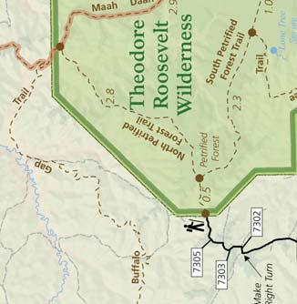
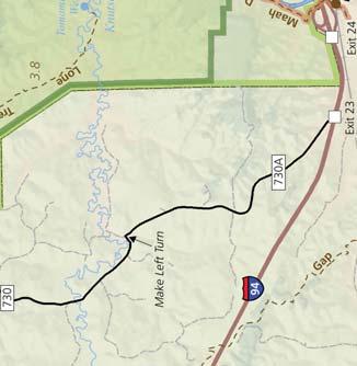
4 The Elkhorn Ranch My home ranch-house stands on the river brink. From the low, long veranda, shaded by leafy cotton-woods, one looks across sand bars and shallows to a strip of meadowland, behind which rises a line of sheer cliffs and grassy plateaus. This veranda is a pleasant place in the summer evenings when a cool breeze stirs along the river and blows in the faces of the tired men, who loll back in their rocking chairs (what true American does not enjoy a rocking chair?), book in hand - though they do not often read the books, but rock gently to and fro, gazing sleepily out at the weird-looking buttes opposite, until their sharp outlines grow indistinct and purple in the after-glow of the sunset. - Theodore Roosevelt, from Hunting Trips of a Ranchman The Elkhorn Ranch site today. A local rancher of the time, J.H. Reid, stated that by 1901,...every scrap of the ranch had disappeared with the exception of a couple of half rotted foundations. THIS SECLUDED AND QUIET SPOT that Roosevelt chose for his Elkhorn Ranch brought much comfort and solitude to a man who was still reeling from personal tragedy. His days were filled with the rewarding labor of cattle ranching and the adventures of hunting. His evenings were spent relaxing on the veranda overlooking the Little Missouri River or at his writing desk. Because it was so important to the greatest conservationist in presidential history, the National Park Service chooses to leave this special place as undeveloped as possible. The park does not intend to rebuild the house or other structures. Take time to wander the trails, sit quietly at the house site, and listen to the cottonwood leaves rustling in the trees. Let the solitude and beauty of this rugged landscape calm and inspire you, just as it did our Conservationist President. Getting There You should plan on approximately one hour to drive to the site from the. High Clearance vehicle recommended. Begin your journey west-bound on I-94. Take exit 10 at Camel Hump Lake. Journey north (or right) along County Road 11. Follow the main road as it curves. Continue along until you come to the intersection of County Road 11 and Westerheim Road, approximately 13.5 miles from the interstate. Bear right along Westerheim Road. Follow this road until you pass Westerheim Hall on the right - a small wooden building approximately 1.5 miles from the intersection. Shortly after the hall, approximately 0.5 miles, turn left onto Bell Lake Road (708). Follow this road approximately 11.5 miles until you reach FH 2. There will be signs directing you to the Elkhorn Campground. Turn right. Continue past the turn for the Elkhorn Campground until you reach the Elkhorn Ranch Parking Area, approximately 3 miles. Check current road conditions at the visitor center before making the drive. Petrified Forest THE NORTH DAKOTA BADLANDS contain a wealth of fossil information including bands of lignite coal and Attention: petrified trees, as well as fossils of freshwater clams, crocodiles, alligators, turtles, and champsosaurs. Each fossil is like a piece in a giant puzzle that scientists have used to reconstruct the ancient history of the park. The hike to Petrified Forest is approximately 3 miles round-trip, out and back. If you follow the whole loop, be prepared for a 10 mile hike! These clues indicate that the park was once on the eastern edge of a flat, swampy area covered with rivers that fanned out into a broad, sea-level delta. This swampy region contained dense forests of sequoia, bald cypress, magnolia, and other water-loving trees growing in or near the shallow waters. Some forests were buried by flood deposits or volcanic ash falls. When silicarich water soaked into the trees, organic compounds in the wood were dissolved and replaced by very small crystals of quartz. This is petrification. Theodore Roosevelt National Park has the third most important collection of petrified wood in North America. No roads lead to this area, keeping it remote and well preserved. Head out for an adventure of discovery! A three mile roundtrip hike will have you strolling through the remains of this ancient forest. Petrified stumps eroding out of the hillside. Getting There Everything within a National Park is protected for ourselves and future generations. If you witness anyone collecting petrified wood or defacing these beautiful trees, please report it to a ranger as soon as possible. You should plan on approximately a 40 minute drive to get to the trailhead. High Clearance vehicle recommended. Begin your journey west-bound on I-94. Take exit 23. Journey north (or right) along Forest Service Road 730. At the entrance to the Myers ranch, continue left to follow Road 730. There is a Private Road sign, however, as a visitor to the park, you have permission to follow this road. Continue along Road 730 until you get to Road You will see a sign for Petrified Forest. Turn right. After turning on 730-2, take your first left. When you get to the next Y, veer left. Park in the parking area. Locate the lift gate in the fence east of the parking area. This is the beginning of the trail. Check road conditions at the visitor center before making the drive. Dynamic Geology in the LAST YEAR WAS AN INCREDIBLY WET year for western North Dakota. The result: geology in action. Part of what creates the beautiful scenery you enjoy at Theodore Roosevelt National Park is the variety of rock layers, including bentonite clay. Commercially used in kitty litter and waterproofing basements, this mineral is known for its ability to soak up water and swell to several times its size. As it swells and contracts, it causes movement and slumping in the rock layers above and around it. The park road is a good example of what happens when you build on such unstable layers. Have you noticed how plants avoid growing on the exposed slopes in the park? On these slopes, erosion is a constant threat. The road is being rebuilt this summer. We anticipate this section of road will be closed to vehicles through August. 4 Visitor Guide
5 County Road 11 Bell Lake Road Hey Missouri Elkhorn Ranch & Petrified Forest Miles Kilometers 1:120, Theodore Roosevelt National Park Elkhorn Ranch Unit Elkhorn Camp "; FH2 719 Blacktail Road 702 River 708 East River Road Missouri 702A Mike's Creek Road Little #0 Cooks Peak Maah Daah 708 Trail 725 Westerheim Road Westerheim Road Wannagan Camp "; River 734 Frank's Creek Road 25th SW UV 11 Little West Twin Butte East Twin Butte East River Road 702 Twin Buttes Road 730 Trail Petrified Forest Theodore Roosevelt Wilderness Maah Daah Roundup Horse Camp "; Make Right Turn 7302 Hey UV 11 Sentinel Butte Exit 10 Camels Hump Butte 94 Buffalo Gap Campground "; Gap Exit Make Left Turn Buffalo 730A Exit 23 Exit 24 Trail "; " Cottonwood Campground and Picnic Area " Medora Exit Visitor Guide 5


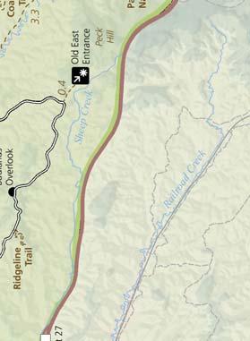
6 Map Road Closure Summer 2012 May be closed in winter 3 Miles Kilometers 1 : 50,000 ROAD CLOSURE The Scenic Drive is closed to vehicles beyond mile 6. The road is still open to cyclists and hikers. It is anticipated the road will remained closed to vehicles through August 2012, possibly longer. Check our website for current road conditions. Turn to page 4 to learn more. 6 Visitor Guide


7 Map 1 Road may be closed in winter 5 Road may be closed in winter Miles Kilometers 1 : 70,000 Visitor Guide 7
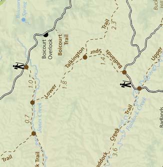
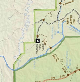
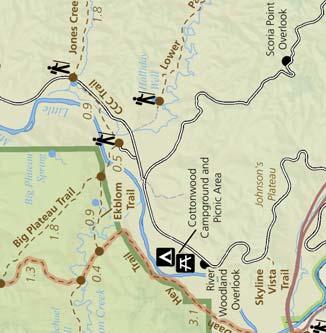
8 Hiking Guide for TRNP Hiking Trail Round-Trip Average Time & Distance Trail Description Easy 1 Skyline Vista 10 minutes 0.1 mi / 0.16 km Feel the wind in your hair high atop Johnson s Plateau. This flat, paved nature trail is perfect for those who want to step out for just a moment. 2 Boicourt Overlook Trail 15 minutes 0.2 mi / 0.3 km One of the most beautiful overlooks is accessible by this easy nature trail with slight grade. This overlook is a ranger favorite for sunset over the badlands! 3 Little Mo Trail minutes 0.7 mi / 1.1 km (paved inner loop) 1.1 mi / 1.8 km (unpaved outer loop) Explore the river bottom habitat along a paved nature trail with slight grades. Take along a trail brochure, available at the trailhead, to learn as you adventure. 4 Buck Hill 10 minutes 0.2 mi / 0.3 km You ll be on top of the world when you climb to the highest accessible point in the park. This is a short, but steep trail. The view from the top is worth every step. 5 Wind Canyon Trail Easy to Moderate 6 Ridgeline Trail 15 minutes 0.4 mi / 0.6 km 20 minutes 0.6 mi / 1 km Enjoy hiking this nature trail alongside a wind sculpted canyon as you climb to the best view of the Little Missouri River the has to offer. Another ranger favorite for sunsets! Explore the badlands environment along a nature trail with moderate to steep grades. Take along a trail brochure, available at the trailhead, to learn as you adventure. This trail has stairs. 7 Coal Vein Trail minutes 0.6 mi / 1 km (inner loop) 0.8 mi / 1.3 km (outer loop) Although this coal vein is no longer burning, this nature trail is an excellent place to learn about badlands geology and ecology. Take along a trail brochure, available at the trailhead. This trail has stairs. 8 Painted Canyon Nature Trail 45 minutes 0.9 mi / 1.4 km The canyon looks amazing from the rim, but wait until you experience a hike down into it! Get up close and personal with the rock layers, junipers, and wildlife. Remember, every step down means a step back up on the return. 9 Caprock Coulee Nature Trail 1 hour 1.5 mi / 2.4 km Hike through badlands terrain and dry washes as you experience a variety of habitats. Take along a trail brochure, available at the trailhead, to learn as you adventure. 10 Prairie Dog Town via the Buckhorn Trail 1 hour 1.5 mi / 2.4 km Start at the Caprock Coulee Trailhead and follow the Buckhorn Trail to a prairie dog town. Be sure to plan some extra time for wildlife viewing; where there are prairie dogs, there are often lots of other animals, too! 11 Sperati Point via the Achenbach Trail Moderate to Strenuous Caprock Coulee 1 hour 1.5 mi / 2.4 km 2 3 hours 4.3 mi / 6.9 km Begin at Oxbow Overlook. A gently rolling walk leads to an overlook of the Little Missouri River. Along the way, pay attention to the wide variety of forbs and grasses. The prairie ecosystem is one of the most diverse on the planet! The first 0.75 miles of this trail consists of the Caprock Coulee Nature Trail. The trail becomes more strenuous as it climbs to the top of a grassy butte, follows a ridgeline with incredible views, and descends back down. Maah Daah Hey Lone Tree Loop Petrified Forest Loop Buckhorn Jones/Lower Talkington/ Lower Paddock Loop Upper Paddock/ Talkington Loop Achenbach 3 4 hours (one way) 7.1 mi / 11.4 km (one way) 5 6 hours 9.6 mi / 15.4 km 5 6 hours 10.3 mi / 16.6 km 6 8 hours 11.4 mi / 18.3 km 6 8 hours 11.4 mi / 18.3 km 8 10 hours 15.4 mi / 24.8 km 19.4 mi / 31.2 km (Painted Canyon) hours 18 mi / 30 km The Maah Daah Hey Trail stretches 96 miles across the National Grassland connecting all three units of the park. This portion of the trail runs through the. You can begin this trail at Peaceful Valley Ranch by following the Ekblom Trail. To avoid a river crossing, access the loop via the Maah Daah Hey Trail. This will add 3.2 miles round trip. Be aware of difficult stream crossings. Located in the remote northwest corner of the, this hike takes you through ancient petrified forests and badlands wilderness. The loop includes the North and South Petrified Forest Trails as well as the Maah Daah Hey. Hike through prairie dog towns, sagebrush terraces, deep canyons, and high open prairies. Experience the diversity of plant and animal life in these distinct habitats. This loop combines the Jones Creek Trail, the Lower Talkington Trail, and the Lower Paddock Creek Trail. Add it to the Upper Paddock/Talkington Loop for an epic adventure of 23.4 miles. This trail combines part of the Lower Talkington Trail with the Upper Talkington and Upper Paddock Creek Trails. Accessing the loop from Painted Canyon will add 4 miles round trip to your hike. Steep climbs and descents and two river crossings await you on a trail that leads deep into the heart of the Theodore Roosevelt Wilderness. Cross the Little Missouri River at daybreak and climb the buttes to greet the rising sun. 8 Visitor Guide


9 COLLECT THEM ALL: Theodore Roosevelt NP Knife River Indian Villages NHS Junior Trader at Fort Union Trading Post NHS Junior Paleontologist All programs are free of charge. Ask at park visitor centers for more information. Junior Rangers JUNIOR RANGERS ARE AN ELITE CLASS OF YOUNG PARK ENTHUSIASTS. THEY dedicate their time and energy to the protection and care of National Parks. They learn valuable lessons and gain a deeper understanding of the natural and cultural history of the places they visit. All Junior Ranger hopefuls should report to their nearest visitor center. There, they will be given an activity book to complete. Those who complete the activities specified for their age group will be sworn in and awarded a badge. Most programs can be completed in as little as half a day. Family Fun Packs and Discovery Packs Explore this country and its most precious protected areas. There are over 397 units of the National Park System, many of them offering this program. See how many badges you can collect! Upper Photo: Junior Rangers being sworn in at Theodore Roosevelt National Park. Bottom Photo: One family takes collecting Jr. Ranger Badges very seriously! Both the boys had sashes as full as the girls. DID YOU NOTICE A WILDFLOWER THAT YOU COULDN T IDENTIFY? HAVE YOU BEEN SQUINTING AT EAGLES SOARING overhead because you left your binoculars at home? Problem solved! Borrow a Family Fun Pack or Discovery Pack! It costs nothing and is packed with helpful tools like field guides, hand lenses, binoculars, an informational booklet, creative activities, and games. You ll be fully equipped for a day of discovery and learning. FAMILY FUN PACKS THEODORE ROOSEVELT NATIONAL PARK May be borrowed for up to 24 hours A credit card or driver s license is required for checkout. Must be returned during visitor center open hours. Available to everyone and every age group DISCOVERY PACKS KNIFE RIVER INDIAN VILLAGES NHS A credit card or driver s license is not required for checkout. Must be returned during visitor center open hours. Available to everyone and every age group The Emerald Enemy THIS IS A TRAVELING LITTLE BUG! ORIGINALLY FROM ASIA, IT IS BELIEVED the Emerald Ash Borer hitchhiked its way across the ocean on wooden shipping crates. It was discovered in Michigan in 2 after tens of thousands of ash trees began to die. The larvae of the beetle burrow under the bark and feed. They leave behind S-shaped galleries that block the flow of nutrients, killing the tree within months. The tree has no defense for this and an infestation is always fatal. The workers in the photo are cleaning up a dead ash forest in order to prevent further spread of the beetle. From 2 through 2011, this tiny green beetle has spread to 15 states, as well as Ontario and Quebec. It has been responsible for the deaths of more than 50 million ash trees in the U.S. This insect has the potential to eliminate ash from North America, says Michael Brown of the USDA. It attacks all species of ash and it kills 100 percent of what it attacks. Surveys have shown little natural movement of the insect. Experts are focused on preventing the spread by human means. The primary way the beetle travels is on loads of firewood carried by travelers from one state to another. Stowed away among the kindling and logs are tiny eggs and larvae that will develop into adult beetles. About 50 percent of the hardwood trees in Theodore Roosevelt National Park are Ash Trees. How can you protect them? BUY AND USE LOCAL WOOD. If you have brought wood from home, burn it as soon as possible - even if you have come from an area without a known population of Emerald Ash Borer. There is lag time between when the beetle arrives and when the trees begin to die. Your area could be infected and you may not know it. Thank you for your help! Visitor Guide 9


10 Fort Union Trading Post NHS Superintendent Andy Banta Mailing Address Fort Union Trading Post NHS Highway 1804 Williston, North Dakota Park Information Website Find us on Facebook and Twitter Fax Number Lost and Found EMERGENCY Dial 911 or contact a uniformed park employee Hours of Operation Winter Hours: Labor Day Memorial Day Daily 9:00 am 5:30 pm, CT Summer Hours: Memorial Day Labor Day Daily, 8:00 am 6:30 pm, CT The Fort is closed Thanksgiving Day, Christmas Day, and New Year s Day. Admission is free. National Park Service U.S. Department of the Interior Fort Union Trading Post NHS WELCOME TO FORT Union Trading Post National Historic Site. A trip to Fort Union takes you back in time to the mid-19th century, the heyday of Fort Union and the fur trade on the Upper Missouri River. Fort Union Trading Post was the most important fur trading post on the upper Missouri from 1828 to At this post, the Assiniboine, Crow, Cree, Ojibway, Blackfeet, Hidatsa, and other tribes traded buffalo robes and other furs for trade goods such as cloth, guns, blankets, knives, cookware, and beads. EXPLORE THE POST This partially reconstructed trading post serves as a stage for living history interpretation. During the summer, various fur trade personnel are portrayed within the courtyard of the trading post. Walk in the steps of many famous individuals from several countries and cultures such as Kenneth McKenzie, Alexander & Natawista Culbertson, George Catlin, Father Pierre DeSmet, John James Audubon, Sitting Bull, Karl Bodmer, and Jim Bridger. AVAILABLE ACTIVITIES -Use the self-guiding map to tour the reconstructed fort. -Visit the visitor center, museum, and bookstore inside the Bourgeois House. -Watch various films on Fort Union and the fur trade, including Firearms of the Fur Trade, The Buffalo Robe, Mysteries of the Archeological Collection, and more! -Experience the Reconstructed Trade House where living history programs are conducted in the summer. -Junior Trader program for kids. -Bodmer Overlook hiking trail (open seasonally). BODMER TRAIL This two mile trail climbs to the point where in 1833, Karl Bodmer sketched images of Fort Union, Assiniboine Indians, and the confluence of the Missouri and Yellowstone Rivers. The trail passes through the historic ruins of the short-lived railroad town of Mondak and some privately owned pasture land. Please make sure to close all gates while hiking. The parking area and trailhead are on the north side of the highway. Ask for a Bodmer Trail Guide at the visitor center. TRADE HOUSE Our costumed interpreters transport you back to 1851 in the most important building at Fort Union. The Trade House is located between the Fort gates through the south entrance. When tribes came to trade, the main trading sessions were done here. Come learn the stories and history of this unique place. 16 Culbertson North Bainville Missouri Kilometers 0 10 Miles MONTANA 201 Fairview Sidney Yellowstone River Trenton Fort Union Trading Post Fort Buford Cartwright River NORTH DAKOTA Alexander Williston Schedule of Events Fort Rendezvous June Fort Union Trading Post NHS hosts its 30th annual Rendezvous. Come and experience the Upper Missouri s finest fur trade fair at one of the West s most imposing historic sites. Activities include historic demonstrations and traditional American Indian crafts. Join us for the biggest special event of the year! Fort Union Rendezvous Kids Day June 14 A day of fun activities for kids of all ages. Kids can participate in traditional American Indian games, learn Indian sign language and more! Program hours 10:00 am CT to 2:00 pm CT. Indian Arts Showcase August 4-5 Come to the 21st annual Indian Arts Showcase. This event commemorates American Indian history and culture through music, traditional crafts, and lectures by tribal historians and elders from tribes of the Upper Missouri. Traditional dancers and singers will preform each day. Artisans will demonstrate beading, quill work, pipe making, and other crafts. The show will be another exciting opportunity to visit the Fort and enjoy the native cultures. Living History Weekend September 1-3 Re-enactors portray American Fur Company employees and American Indians working and trading at Fort Union. These actors will demonstrate what a living, active fort was like during Fort Union s heyday. Last Bell Tours are historic re-enactments that bring to life one of Fort Union s many stories. They will be performed Saturday evening beginning at 8:00 pm CT. 10 Visitor Guide


11 Knife River Indian Villages NHS Superintendent Wendy Ross Mailing Address Knife River Indian Villages NHS P.O. Box County Road 37 Stanton, North Dakota Park Information Website Fax Number Lost and Found National Park Service U.S. Department of the Interior EMERGENCY Dial 911 or contact a uniformed park employee Hours of Operation Winter Hours: Labor Day Memorial Day Daily 8:00 am 4:30 pm, CT Summer Hours: Memorial Day Labor Day Daily, 8:00 am 6:00 pm, CT The visitor center is closed Thanksgiving Day, Christmas Day, and New Year s Day. Park Grounds are open until 10:00 p.m. Admission is free. Knife River Indian Villages NHS WELCOME TO KNIFE River Indian Villages National Historic Site, where history comes alive. By touring our visitor center, you can learn about Northern Great Plains Indian Culture as well as native plants and animals. Stroll through the museum and enjoy a 15 minute film describing life in an Indian Village from the perspective of Maxidiwiac. Step back in time as you walk through the remains of village sites. RANGER PROGRAMS Take your park experience to a whole new level! Ranger Programs are available Memorial Day through Labor Day. Programs are free and visitors of all ages are welcome. MORE FUN! Discovery Packs containing bird guides, binoculars, magnifying glasses, and a pack of wildflower cards are available for checkout at the visitor center. This is a free service. Jr. Ranger Booklets are available for kids For ages 3-5, Jr. Explorer booklets are available. Return them to the visitor center to receive your badge or button. Turn to page 9 to learn more Schedule of Events Ninth Annual Knife River Bird Watching Event May 19 Gather at the 7 Trails Trading Post, located between the city of Stanton and Knife River Indian Villages NHS, for breakfast and bird watching. Don t forget to dress for the weather and bring your field glasses. Spring Photography-in-the-Field Workshop May 19 Whether you are a professional or you are just getting started, join our group for the practical application of photography lessons. All camera formats are welcome - from point and shoot, to digital SLR, to film. Kid s Camp July 10, 17, 24, & 31 Tuesdays in July, children ages 6 to 12 can participate in special activities at the park. Each Tuesday focuses on a different theme. Join for one or all four weeks. For safety reasons, those who wish to participate on the 31st must have already attended at least one other week. Please reserve your space in advance by calling Northern Great Plains Culture Fest July All ages are invited to enjoy free cultural demonstrations, participate in games, and learn about the lives of people that lived on the Plains from their descendents. The event will encompass a wide range of activities exemplifying challenges of living on the Northern Plains. Rolling hills and the Knife River serve as the backdrop for this two day event. Fall Photography-in-the-Field Workshop September 29 Whether you are a professional or you are just getting started, join our group for the practical application of photography lessons. All camera formats are welcome - from point and shoot, to digital SLR, to film. Winter Adventure* February of 2013 Knife River Indian Villages NHS, in partnership with the State Historical Society of North Dakota, presents a day of winter activities including learning about American Indian crafts, a snowshoe hike into the villages, and dinner in an earthlodge with special presentations by American Indian storytellers and artists. *Fee Applies Attention Teachers: Would you like a Park Ranger from Knife River Indian Villages NHS to visit your classroom? Distance learning technology makes it possible for Park Rangers to visit classrooms anywhere in the country. Curriculum-based programs are available focusing on the Hidatsa, Mandan, and Arikara cultures. Other historical, cultural, or natural history topics can be tailored to your curriculum. For additional information, please visit the For Teachers section of the park s website at or contact the park s Education Specialist at Distance learning programs are free. Distance learning programs are available from many National Park sites. Visit for a complete listing. Hiking Guide Hiking Trail Round-Trip Time & Distance Trail Description Village Trail 30 minutes 1.3 mi / 2.1 km The Village Trail begins at the visitor center and leads to two village sites: the Lower Hidatsa Village and the Sakakawea Village (Awatixa Village). There is a loop at the second village site that includes a walk along the Knife River. North Forest Trail 2 3 hours 5 mi / 8.0 km Two Rivers Trail 3 4 hours 6.2 mi / 10 km The North Forest Trail cuts through bottomland forest and native prairie. It has spectacular views of the Missouri River. Upon entering the forest, you can chose to walk 0.1 miles on the Big Hidatsa Trail to the Big Hidatsa Village. The Two Rivers Trail follows the Knife River to the south end of the park. At the southern tip of the trail you can see where the Knife River flows into the Missouri River. FISHING AT KNIFE RIVER For an opportunity to catch walleye, catfish, or pike, fish from the shore of the Knife River. The parking lot of the Sakakawea Site is a great location. North Dakota fishing regulations apply. Applicable state license is required. Visitors under the age of 16 may fish without a license. Visitor Guide 11

12 Supporting our National Parks THEODORE ROOSEVELT NATURE & HISTORY ASSOCIATION WAS ORGANIZED IN 1951 BY A GROUP of park enthusiasts to promote and support the historical, scientific, and educational activities of Theodore Roosevelt National Park. This commitment has broadened to offer support to Knife River Indian Villages National Historic Site and Upper Souris National Wildlife Refuge. The Association is a non-federal, nonprofit organization governed by a volunteer board of directors. To accomplish its goals, the Association is authorized by the National Park Service to sell publications, maps, interpretive learning tools, and theme-related items. From its inception, the Association has donated more than $870,000 from the sales receipts of these materials to the National Park Service and the U.S. Fish & Wildlife Service areas in North Dakota. This money has been used to support interpretive and visitor service activities such as trail guides, exhibits, informational handouts, and funding for new site-specific publications. The Association has also paid for housing for volunteers, supported park libraries, sponsored scientific research, funded Student Conservation Association interns, and many other projects. You are invited to enjoy the visitor centers that house our bookstores, and we remind you that all purchases will directly support the park. The association takes great pride in its ability to provide assistance to our natural areas throughout North Dakota. Enjoy the adventure! Annual Membership benefits Include: 15% discount in all TRNHA bookstores. A discount on items purchased at other National Park Cooperating Association bookstores. Monthly e-newsletter and program announcements on the activities of the association and areas it serves. The pleasure of knowing that your membership contributes to the support of park and refuge sites in North Dakota! Membership Registration Form New Renewal Individual $20.00 Family $30.00 Contributing $75.00 Supporting $ NAME ADDRESS CITY STATE ZIP Please Make Checks Payable to: Theodore Roosevelt Nature & History Association PO Box 167, Medora, ND info@trnha.org Visit our website at 2 Miles «8 Kilometers Fort Union Trading Post National Historic Site « «16 Bainville Sydney «68 Williston 85 Watford City 1804 «23 Theodore Roosevelt National Park New Town Fort Berthold Reservation « «28 83 Garrison «41 «53 μ «14 «16 94 MONTANA NORTH DAKOTA Wibaux «16 Beach Little Missouri River National Grassland Theodore Roosevelt National Park Elkhorn Ranch Unit Medora 85 Theodore Roosevelt National Park Belfield 85 «22 «22 Killdeer Dickinson «8 «49 Richardton Beulah Knife River Indian Villages National Historic Site Stanton Washburn «41 «48 «31 «25 New Salem Wilton Bismarck « «36 94 «14 83 What s Going on Around Here?! Surprised by the amount of truck traffic in the area? Unable to get a hotel reservation? Can t find the sleepy cowboy towns you remember? The reason for the incredible changes this area is experiencing lies two miles below the surface of western North Dakota - a formation called the Bakken. The Bakken formation is a rock layer rich with oil reserves. Until recently, the oil was not extractable. A new and controversial technique hydraulic fracturing or fracking has allowed oil companies to more than quadruple their daily oil production in the last five years. The huge influx of activity has brought tens of thousands of new jobs to the area. In a national economy where jobs are scarce, North Dakota has become the land of opportunity for many. All three North Dakota National Parks are experiencing serious issues due to the oil boom. New wells are going in every month; many can be seen from inside park boundaries. Each new well means another drill rig, well pad, pumpjack, debris pit, flare pit, storage tanks, and access road on the landscape. Each new well requires 0 trucking events to complete its setup and to begin pumping oil. Noise and dust from heavy truck traffic and pumping equipment is constant. Numerous flares can be seen in the formerly dark night sky as excess natural gas is burned off. Socioeconomic impacts are altering local communities. A multifaceted topic to be sure, the oil boom begs a difficult question: how can we develop our resources while still protecting our parks and communities? 12 Visitor Guide 40% post-consumer
Visitor Guide. Celebrating 100 Years of America s Best Idea C. Summer 2015 Winter National Park Sites of North Dakota
 National Park Sites of North Dakota National Park Service U.S. Department of the Interior Visitor Guide Summer 2015 Winter 2016 Theodore Roosevelt National Park Fort Union Trading Post National Historic
THEODORE ROOSEVELT NATURE & HISTORY ASSOCIATION NEWSLETTER
 THEODORE ROOSEVELT NATURE & HISTORY ASSOCIATION NEWSLETTER July 2017 HAVE YOU VISITED KNIFE RIVER S EARTHLODGE? With their mastery of agriculture, tribes living in the Upper Missouri River Valley developed
Crystal Lake Area Trails
 Lake Area Trails Welcome to the Lake area of the Big Snowy Mountains! This island mountain range in central Montana features peaks reaching to 8,600 feet and long, high ridges from which vistas of the
Other Agencies and Organizations
 Daniel Boone National Forest 1700 Bypass Road WInchester, KY 40391 859-745-3100 Location Northern terminus is near Morehead, Kentucky. Southern terminus is located in the Big South Fork NRRA in Tennessee.
ANGEL PEAK SCENIC AREA
 Activities: Facilities: ANGEL PEAK SCENIC AREA Hiking, photography, watchable wildlife, camping, picnicking. Note: While formal hiking trails in the area are limited, dispersed hiking opportunities abound
Post IRU FAM West Legends May 6-10
 Post IRU FAM West Legends May 6-10 ***Please bring a smaller bag with you to use for the items you may need on the post FAM. There will not be room in the van for all luggage. Your additional luggage will
B HALL RANCH FISHTAIL, MONTANA
 Brochure Courtesy of: B HALL RANCH FISHTAIL, MONTANA w w w. m c c a s l i n l a n d. c o m Page 1 LOCATION The Hall Ranch is ideally located in the foothills of the Beartooth Mountains, approximately 5
A Publication of Friends of Sleeping Bear Dunes
 A Publication of Friends of Sleeping Bear Dunes 2014, Friends of Sleeping Bear Dunes, P.O. Box 545, Empire, MI 49630 www.friendsofsleepingbear.org info@friendsofsleepingbear.org Learn more about the Friends
All information and pictures copyright of
 FREE McKenzie County is located in the western North Dakota in the heart of the Williston Basin. The community enjoys a diversified economy in a small town setting. Agriculture, oil extraction, financial
PAUL S PLACE ELK, DEER AND VIEWS FISHTAIL, MONTANA
 McCaslin Land 2010 PAUL S PLACE ELK, DEER AND VIEWS FISHTAIL, MONTANA LOCATION Paul s Place is ideally located in the foothills of the Beartooth Mountains, approximately 5 to 5-1/2 miles west of Fishtail,
GOLDEN EARS PROVINCIAL PARK
 GOLDEN EARS PROVINCIAL PARK Trail Information as of October 10 th 2015 Do not underestimate the mountainous wilderness of Golden Ears Provincial Park. The combination of rugged terrain and rapidly changing
Cataloochee. Fishing Species Rainbow Trout and Brook Trout. Recreation
 Cataloochee River Information The Cataloochee River is located in the historic Cataloochee Valley--a relatively remote part of Smoky Mountain National Park. The campground is a secluded setting and offers
National Park Service U.S. Department of the Interior FREE
 Park Newspaper National Park Service U.S. Department of the Interior FREE Frontier Fragments The official newspaper of Theodore Roosevelt National Park Spring 2009 - Spring 2010 Little Missouri River Welcome
discover Genuine Montana The Last Best Place Great Falls Montana
 discover Genuine Montana The Last Best Place Great Falls Montana the grandest sight I ever beheld... 1805 Meriwether Lewis journal entry Resting on the high plains along Montana s Rocky Mountain Front
Logo Department Name Agency Organization Organization Address Information 5700 North Sabino Canyon Road
 Logo Department Name Agency Organization Organization Address Information United States Forest Coronado National Forest 5700 North Sabino Canyon Road Department of Service Santa Catalina Ranger District
DOGS ARE NOT PERMITTED ON TRAILS OR TOURS
 Tuesday, January 1, 2008 9:00 a.m. Hike Voices, Visions, and Views of Alcoholic Pass 3 Hours Hike Alcoholic Pass! Experience and discover the prehistory, history, and present day journey of those who have
Important Sites to Visit
 Important Sites to Visit Pompey s Pillar Rates & Fees $3.00 per vehicle (Day - until May 1, 2007) $100.00 per bus or group Admission is free with Golden Age, Golden Access, and Golden Eagle Passports.
Little Grand Canyon near Pomona, Illinois
 Little Grand Canyon near Pomona, Illinois Below: View of the trail and the terrain created using the Map My Hike app Below: Summary of the hike created using the Map My Hike app Presented by: Jennifer
BRYCE CANYON COUNTRY Boulder Mountain Scenic backways itinerary
 BRYCE CANYON COUNTRY Boulder Mountain Scenic backways itinerary Boulder Mountain Area The high plateaus of the Aquarius Plateau (Boulder Mountain), are heavily forested and covered in countless winding
Dumont Dunes Special Recreation Management Area (SRMA)
") Dumont Dunes Special Recreation Management Area (SRMA) RMA/RECREATION MANAGEMENT ZONE (RMZ) OBJECTIVE(S) DECISIONS Objective Statement: Designate this area as a Special Recreation Management Area. To manage
Dumont Dunes Special Recreation Management Area (SRMA) RMA/RECREATION MANAGEMENT ZONE (RMZ) OBJECTIVE(S) DECISIONS Objective Statement: Designate this area as a Special Recreation Management Area. To manage
2019 DAY HIKE AT IRON MOUNTAIN SATURDAY, JANUARY 19
 WHERE? In Google Maps, paste the following coordinates for Iron Mountain: 32.978215,-116.972593 or CLICK ON THIS LINK. I. Purpose of the Day Hike A. THE WBC Day Hike is a relatively short trail hike to
Stephens State Park Trails
 TRAILS OF ALLAMUCHY MOUNTAIN & STEPHENS STATE PARKS Allamuchy Mountain and Stephens State Parks contain 28 marked trails providing access to diverse landscapes for walking, hiking, biking, bird-watching,
Bear Butte State Park Trail System NORTH
 Trail System 4426 4250 4000 3750 3500 3250 NORTH SCALE IN FEET 0 1000 2000 Summit Trail Type of trail: Hiking Length of trail: 1.85 miles Trail surface: Dirt and rock Rated: Moderate, somewhat hilly, even
What are you getting into?
 Overnight Camping What are you getting into? You will be hiking with your gear to a campground about ½ mile away and spending 1 night camping You will help to prepare a meal over an open flame You will
glacier _G4U1W5_ indd 1 2/24/10 4:10:48 PM
 glacier Routine for Lesson Vocabulary Introduce This glacier is huge. A glacier is a great mass of ice moving very slowly down a mountain, along a valley, or over a land area. Let s say the word together:
Yellowstone & Grand Teton: Walking America s First National Park
 Yellowstone & Grand Teton: Walking America s First National Park Yellowstone & Grand Teton: Walking America s First National Park A massive canyon carved by an ancient volcano plumes of water leaping into
Subject to sale, withdrawal, or error.
 The Crawford L Bar Ranch is located approximately 40 air miles west of Albuquerque, New Mexico. This ranch truly epitomizes the description of New Mexico being the Land of Enchantment. The topography and
SDTrucksprings. Indiana Off-roading/4x4 Guide Copyright 2015 We Specialize In:
 SDTrucksprings Indiana Off-roading/4x4 Guide Copyright 2015 We Specialize In: Helper Springs Air Bags Leaf Springs Body Lift Kits Coil Springs Timbren Kits Hellwig Springs Lift Blocks And More! Visit www.sdtrucksprings.com
1 Permanent Full Time Forester GS /07/09 Kaibab National Forest Duty Station: Williams or Tusayan, AZ
 1 Permanent Full Time Forester GS-460-05/07/09 Kaibab National Forest Duty Station: Williams or Tusayan, AZ Merit Vacancy Announcement: Open Monday January 11 th to Friday January 20 th 2016 and working
Driving Time: 3 hours (allow extra time for stops)
") Scenic Byways loop This journey takes visitors through the eastern edge of Mt. Rainier National Park and along two of Washington s most beloved scenic byways, the Chinook Byway and the White Pass Scenic
Scenic Byways loop This journey takes visitors through the eastern edge of Mt. Rainier National Park and along two of Washington s most beloved scenic byways, the Chinook Byway and the White Pass Scenic
Glacier National Park
 Glacier National Park West Glacier, MO Page 1 Page 3-6 Report Rough Draft Glacier National Park Glacier National Park is located in the northwest corner of Montana and extends into Canada. It is located
(Short Listing) DUPUYER ACREAGE, ROCKY MOUNTAN FRONT
 DUPUYER ACREAGE, ROCKY MOUNTAN FRONT") (Short Listing) DUPUYER ACREAGE, ROCKY MOUNTAN FRONT This unique property is located 8½ miles northwest of Dupuyer, Montana and approximately thirty 30 miles northwest of Choteau, Montana. Great Falls
(Short Listing) DUPUYER ACREAGE, ROCKY MOUNTAN FRONT This unique property is located 8½ miles northwest of Dupuyer, Montana and approximately thirty 30 miles northwest of Choteau, Montana. Great Falls
26 Utah s Patchwork Parkway SCENIC BYWAY CORRIDOR MANAGEMENT PLAN (SR 143)
") Natural Natural Quality applies to those features in the visual environment that are in a relatively undisturbed state. These features predate the arrival of human populations and may include geological
Natural Natural Quality applies to those features in the visual environment that are in a relatively undisturbed state. These features predate the arrival of human populations and may include geological
Colorado Life Zone Scavenger Hunt
 Colorado Life Zone Scavenger Hunt Below are worksheets created for all the habitats or life zones. They were designed with the intention of breaking the class up into small groups, and having students
Witte Museum Tour Meyers Spring Ranch Tour Saturday, September 1, a.m. - 4 p.m.
 Witte Museum Tour Meyers Spring Ranch Tour Saturday, September 1, 2018 10 a.m. - 4 p.m. This tour is limited to 35 participants (Ages 12 and up) All minors must be accompanied by a parent or legal guardian.
Children's Discovery Trail Guide - Lost Creek
 Children's Discovery Trail Guide - Lost Creek Thank you for spending time learning and observing some of the secrets of Red Rock Canyon Conservation Area has to offer. Feel free to talk to a ranger if
ACTIVITY GUIDE. Buckboard Grill & Grocery: 4122 OUR MISSION
 ACTIVITY GUIDE PROGRAMS FOR THE WEEK OF MARCH 25, 2016 - APRIL 1, 2016 SNOW MOUNTAIN RANCH Programs Office 970-887-2152, ext. 4135 snowmountainranch.org 8:30AM-5PM Daily OUR MISSION YMCA of the Rockies
TAYLOR CANYON RANCH COLORADO - ROUTT COUNTY - STEAMBOAT SPRINGS
 TAYLOR CANYON RANCH COLORADO - ROUTT COUNTY - STEAMBOAT SPRINGS Tucked up against the steep valley shaped by Mt. Pau and rising to the Routt National Forest, Taylor Canyon Ranch is an easily accessible,
FOR SALE. Log Home on 2.27+/- Acres Custer County, South Dakota Offered at $647,000.
 FOR SALE Highlight Features: 5,134 square foot, four bedroom, three and a half bath Cypress Log Home City water and sewer Easy access to endless recreational opportunities Only five minutes to Custer State
SAN MIGUEL CREEK RANCH. q Trinidad, Las Animas County, Colorado q
 SAN MIGUEL CREEK RANCH q Trinidad, Las Animas County, Colorado q 2 s San Miguel Creek Ranch is a scenic well-balanced cattle and trophy hunting ranch that showcases the very best of Southern Colorado.
Bureau of Land Management Public Lands Guide Northwest District
 Bureau of Land Management Public Lands Guide Northwest District NORTHWEST Fee Site Restrooms Picnic Sites Developed Campgrounds Farmington Field Office (505) 564-7600 Alien Run Mountain Bike Trail Angel
CRAZY HORSE TRAIL GUIDE
 CRAZY HORSE TRAIL GUIDE Abridged Version: July 2016 This is a short form of our interpretive trail guide for the Crazy Horse Trail. The full version of the guide has a more detailed description of the
Sunrise Ranch 6890 acres, Jeff Davis County, Texas On the Fort Davis Scenic Loop
 Sunrise Ranch 6890 acres, Jeff Davis County, Texas On the Fort Davis Scenic Loop 432-386-2821 Cell 432-426-2024 Office james@kinglandwater.com King Land & Water LLC P.O. Box 109, 600 State Street, Fort
Weston County, Wyoming
 The Sweet 200-Acre Property Weston County, Wyoming A unique opportunity to own a little piece of the old West, where one can experience unparalleled scenery, adventure and history walk in the footsteps
2018 HIGH ADVENTURE SECTION. SUPPORT & HELP (605)
") SUPPORT & HELP (605) 342-2824 reservations@blackhillsbsa.org www.mountain.blackhillsbsa.org TABLE OF CONTENTS Contents Pricing... 4 Dates... 4 Participation Requirements... 4 Risk Advisory... 4 Camp Program
SUPPORT & HELP (605) 342-2824 reservations@blackhillsbsa.org www.mountain.blackhillsbsa.org TABLE OF CONTENTS Contents Pricing... 4 Dates... 4 Participation Requirements... 4 Risk Advisory... 4 Camp Program
Program Itinerary. Teton Science School Jackson Campus is nestled on a 900-acre site filled with creeks, ponds, and aspen, conifer and sage habitats.
 Dear CTY families, We are delighted to invite you on a journey to the northwest corner of Wyoming, one of our nation's most spectacular natural regions. Planned in collaboration with Teton Science Schools,
09 LBL Turkey Bay Off-Highway Vehicle Area Rules & Regulations
 09 LBL Turkey Bay Off-Highway Vehicle Area Rules & Regulations Revised 3-2009 ABOUT TURKEY BAY OHV AREA Turkey Bay Off-Highway Vehicle (OHV) Area is a designated area for OHV riding and camping. Turkey
Proposed Scotchman Peaks Wilderness Act 2016 (S.3531)
") 1 Proposed Scotchman Peaks Wilderness Act 2016 (S.3531) Frequently Asked Questions PLACE Where is the area that would be designated as Wilderness? The lands outlined in S.3531 lie within Idaho along its
1 Proposed Scotchman Peaks Wilderness Act 2016 (S.3531) Frequently Asked Questions PLACE Where is the area that would be designated as Wilderness? The lands outlined in S.3531 lie within Idaho along its
About Us Join the team! Calendar County Map FPPC Forms SPECIAL ALERTS CONTACT US!
 About Us Join the team! Calendar County Map FPPC Forms SPECIAL ALERTS CONTACT US! Search.. Home Reservations Parks Nature Centers Recreation Historic Sites Trails Lake Cahuilla Home Riverside County Parks
SDTrucksprings. Arkansas Off-roading/4x4 Guide Copyright 2015 We Specialize In:
 SDTrucksprings Arkansas Off-roading/4x4 Guide Copyright 2015 We Specialize In: Helper Springs Air Bags Leaf Springs Body Lift Kits Coil Springs Timbren Kits Hellwig Springs Lift Blocks And More! Visit
This letter begins the planning of the annual Hiking Club adventure to the Great Smoky Mountains National Park.
 January 7, 2015 To: Hiking Club Members and Parents From: Gary Banks Subject: Spring Break Backpacking Trip Dear Parents and Students, This letter begins the planning of the annual Hiking Club adventure
TOWER-ROOSEVELT AREA MAP
 TOWER-ROOSEVELT AREA MAP Page 1 of 14 Tower-Roosevelt to Canyon Road Map Yellowstone Tower-Roosevelt Area Page 2 of 14 Tower-Roosevelt to Mammoth Road Map Page 3 of 14 Tower-Roosevelt to the Northeast
INTRODUCTION ITINERARY ANTARCTICA - ANTARCTIC EXPRESS: FLY THE DRAKE TRIP CODE ACTSISFD DEPARTURE DURATION. 7 Days LOCATIONS.
 INTRODUCTION You re ready to explore King George Island and the Antarctic Peninsula and no Drake Passage crossings are required! With a spectacular aerial view, included charter flights between Punta Arenas
School Group Permits for Kananaskis Country Parks and Protected Areas-Memo
 Parks and Protected Areas School Group Permits for Parks and Protected Areas-Memo From: Date: January 4, 2005 Alberta Parks and Protected Areas Telephone: (403) 678-5508 To: All Alberta School Boards and
L o s t I n T i m e R a n c h WIBAUX, MONTANA
 L o s t I n T i m e R a n c h WIBAUX, MONTANA Offered by Jacob L. Korell Broker/Owner Member of Landmark of Billings, Inc. 1925 Grand Avenue, Suite 143 Billings, MT 59102 OFFICE: (406) 248-3101 CELL: (406)
THE GHOST ROSE RANCH. Randy J. Wood Qualifying Broker Cell:
 Wild West Properties, LLC 7020 Santa Marisa, NE Albuquerque, NM 87113 505-836-4558 http://www.wildwestproperties.com/ Randy J. Wood Qualifying Broker Cell: 505-980-8019 E-mail: rjwood5@comcast.net THE
CAMP BLACKBERRY. Family CAMP BLACKBERRY PROGRAM AGE GROUPS CAMP BLACKBERRY SESSIONS
 Family CAMP BLACKBERRY CAMP BLACKBERRY Camp Blackberry is a place where kids can be kids, allowing parents time for each other. We offer time for creativity, learning and exploration. From catching crawdads
Final Recreation Report. Sunflower Allotment Grazing Analysis. July 2015
 Final Recreation Report Sunflower Allotment Grazing Analysis July 2015 Table of Contents Introduction... 3 Affected Environment... 3 Four Peaks Wilderness Area... 3 Dispersed Recreation... 3 Environmental
THE PANTHER S ROAR PO BOX 51 CASHIERS, NC (828) 269-HIKE
 269-HIKE") Friends of Panthertown The Panther s Roar Panthertown Valley WNC THE PANTHER S ROAR PO BOX 51 CASHIERS, NC 28717 WWW.PANTHERTOWN.ORG (828) 269-HIKE Friends of Panthertown News Everybody needs beauty as
Friends of Panthertown The Panther s Roar Panthertown Valley WNC THE PANTHER S ROAR PO BOX 51 CASHIERS, NC 28717 WWW.PANTHERTOWN.ORG (828) 269-HIKE Friends of Panthertown News Everybody needs beauty as
Schedule of Events. 11:15 a.m. 11:45 a.m. Pre-Settlement and Early Settlement History presented by Mike Baughn
 Dear Attendee, Thank you so much for reserving your attendance at The Nature Conservancy in Kansas 25th Anniversary Celebration: Visitors Day at Smoky Valley Ranch, Saturday, June 7th. Please find enclosed
List of Challenges. Draw a Map of Your Hike
 List of Challenges Junior Ranger Wildlife Adventures Draw a Map of Your Hike Explore Pella Crossing Hey kids! Do you love animals as much as the Boulder County Park Rangers? Join us on Saturday, June 2
Asheville & WNC Hikes
 Asheville & WNC Hikes Amazingly, we have 3,000+ miles of free public hiking trails near Asheville, including 1,600 miles in the Pisgah and Nantahala National Forests, 850 miles in Great Smokey Mountains
PHILMONT EXPEDITION UNIT REGISTRATION FOR 2020
 PHILMONT EXPEDITION UNIT REGISTRATION FOR 2020 REMINDERS: Your unit representative may enter the system anytime from October 30 thru December 2. Any unit can enter the registration system in consecutive
General Rules for Use of Lands Managed by the. Middle Peninsula Chesapeake Bay Public Access Authority
 General Rules for Use of Lands Managed by the Middle Peninsula Chesapeake Bay Public Access Authority As a visitor to lands managed by the Middle Peninsula Chesapeake Bay Public Access Authority (PAA),
Yellowstone NATIONAL PARK. with photos by: MICHAEL MELFORD TOM MURPHY ROBBIE GEORGE SERGIO LANZA CASADO TERRY DONNELLY MICHAEL S. LEWIS RAYMOND GEHMAN
 Yellowstone NATIONAL PARK with photos by: MICHAEL MELFORD TOM MURPHY ROBBIE GEORGE SERGIO LANZA CASADO TERRY DONNELLY MICHAEL S. LEWIS RAYMOND GEHMAN GRAND PRISMATIC SPRING PHOTO BY SERGIO LANZA CASADO
FINAL TESTIMONY 1 COMMITTEE ON RESOURCES UNITED STATES HOUSE OF REPRESENTATIVES. July 13, 2005 CONCERNING. Motorized Recreational Use of Federal Lands
 FINAL TESTIMONY 1 STATEMENT OF DALE BOSWORTH CHIEF Of the FOREST SERVICE UNITED STATES DEPARTMENT OF AGRICULTURE Before the SUBCOMMITTEE ON FORESTS AND FOREST HEALTH And the SUBCOMMITTEE ON NATIONAL PARKS,
Comanche National Grassland, Timpas Unit
 Comanche National Grassland, Timpas Unit Heritage Resources More than 540 sites are eligible for listing on the National Register of Historic Places (NRHP) by Forest Service staff and/or the Colorado State
Updated 07/15/ SEASONAL RULES
 Updated 07/15/2017 2018 SEASONAL RULES Table of Contents 1. Seasonal Qualifications... 3 2. Seasonal Rates, Fees and Payment Schedule... 3 3. General Rules... 4 4. Sites... 4 5. Services... 5 6. Gate Cards...
the Cornucopia Canyon Ranch
 the Cornucopia Canyon Ranch Majestic mountains... Rolling hills... Vast meadows... are all part of the beautiful landscape of the Cornucopia Canyon Ranch. Located just 40 miles from Cloudcroft, New Mexico,
2nd Edition Consignment Store 348 Main Street, Delta, Colorado For Sale or Lease
 2nd Edition Consignment Store 348 Main Street, Delta, Colorado For Sale or Lease Longtime Established Consignment Clothing and Accessories Store Located in the Heart of the City of Delta Known for it s
Snowmobile Safety Tips
 Snowmobile Safety Tips The winter weather is bringing out snowmobilers, and safety officials are urging them to be careful. More than 200,000 registered snowmobiles hit Wisconsin s 25,000 miles of groomed
Wilderness Areas Designated by the White Pine County bill
 Wilderness Areas Designated by the White Pine County bill SEC. 321. SHORT TITLE. This subtitle may be cited as the `Pam White Wilderness Act of 2006'. SEC. 322. FINDINGS. Congress finds that-- The White
Pricing: Program pricing is quoted per program below. Adults are free. Parking is free.
 Program Policies Pricing: Program pricing is quoted per program below. Adults are free. Parking is free. Program Scheduling: Programs can be scheduled on Monday - Friday evenings and Saturday and Sunday
INFO FOR GROUP LEADERS
 INFO FOR GROUP LEADERS COMMUNICATE EARLY & OFTEN: Let us know ahead of time if your group size has changed or the ages within your group have changed. Also, let us know in advance if your group has any
2/7/2012. Mission Mountains Wilderness Contracting as a management alternative Climb the mountains and get their good tidings John Muir
 Wilderness Contracting as a management alternative Climb the mountains and get their good tidings John Muir Kari Gunderson Wilderness Education and Management Specialist Swan Valley, Montana In memory
LESSON 5 Wilderness Management Case Studies
 LESSON 5 Wilderness Management Case Studies Objectives: Students will: review the key points of the Wilderness Act of 1964. brainstorm solutions for Wilderness management issues. Materials: Í Leave no
CAMP SUMMER. catalogue. Did You Know... Park Information. Phone: Camps Website:
 Did You Know... Camps held at Riverbend Park and Spring Hill RECenters offer after-care. Please note that camps ending before 3pm are not eligible for after care. See online for more information. A camp
AH-SHI-SLE-PAH WILDERNESS STUDY AREA Page 1 of 7
 Page 1 of 7 Page 2 of 7 FORMATIONS Map #: 1 Name: Ah-shi-sle-pah Rock Garden Latitude: 36.151514 Longitude: -107.92832 FOSSILS Indeterminate Bone Indeterminate Bone Crocodile Scutes Indeterminate Bone
Itinerary Overview: What you will be doing Maroon Bells Alpine Backpacking 22 days
 Itinerary Overview: What you will be doing Maroon Bells Alpine Backpacking 22 days 0BCourse Description Welcome, you re in for an experience of a lifetime! Imagine hiking through rolling forests, sharing
DENVER CMC PHOTOGRAPHY SECTION NEWSLETTER
 PHOTOGRAPHY SECTION DENVER CMC PHOTOGRAPHY SECTION NEWSLETTER Tracks on Trails, page 2 2015 Year of the Mountaineer, page 3 CMC Photo Section s Wilderness Photos page 520 2014 Monthly Meetings 2nd Wednesday
$850,000 Awarded to 20 Organizations
 $850,000 Awarded to 20 Organizations The Conservation Alliance is pleased to fund the following organizations to support their efforts to protect wild lands and waterways for their habitat and recreation
2018 Trip Dates Spectacle Island July 17, 18, 19 July 31, August 1, 2 August 14, 15, 16 August 21, 22, 23 August 28, 29, 30
 Dear Youth Program Partner: June 2018 2018 Trip Dates Spectacle Island July 17, 18, 19 July 31, August 1, 2 August 14, 15, 16 August 21, 22, 23 August 28, 29, 30 Island Highlights 5 miles of trails Lifeguarded
Mt Rushmore, Grand Tetons & Yellowstone 8 Days from $1295
 1 800 422 3727 Mt Rushmore, Grand Tetons & Yellowstone 8 Days from $1295 Itinerary Day 1 Rapid City, South Dakota See some of America s grandest sights Your western adventure begins in Rapid City, South
Witte Museum Tour Painted Shelter on the Rio Grande River Saturday June 2, :30 A.M. 3:00 P.M.
 Witte Museum Tour Painted Shelter on the Rio Grande River Saturday June 2, 2018 9:30 A.M. 3:00 P.M. This tour is limited to 35 participants (Ages 12 and up) All minors must be accompanied by a parent or
Great Smoky Mountains National Park Summer Ranger Programs June 17-Aug 11, 2018
 Great Smoky Mountains National Park Summer Ranger Programs June 17-Aug 11, 2018 Sundays: Coffee With a Ranger 10:00 a.m. Join a Ranger for a cup of coffee and find out what s happening in the park! Coffee
TOPIC = CAMP SITE SELECTION
 TOPIC = CAMP SITE SELECTION I. RESOURCES a. Guide to safe scouting. who can participate and what can they do. trail safety. safety from lightning. b. BSA field book. c. Camping merit badge booklet. d.
Potomac Gorge. Resource Booklet. A Natural Monument in the Shadow of National Monuments. Bridging the Watershed. Potomac Gorge 75
 Potomac Gorge Potomac Gorge A Natural Monument in the Shadow of National Monuments Resource Booklet Bridging the Watershed An outreach program of the Alice Ferguson Foundation in partnership with the National
When is Coulee Clean-Up? Starts Earth Day (April 22) through May 31; although you can complete a clean-up at any time of year!
 through May 31; although you can complete a clean-up at any time of year!") 1 What is Coulee Clean-Up? Coulee Clean-Up is a volunteer conservation project coordinated by the Helen Schuler Nature Centre aimed at preserving and protecting the environment of the Lethbridge river
1 What is Coulee Clean-Up? Coulee Clean-Up is a volunteer conservation project coordinated by the Helen Schuler Nature Centre aimed at preserving and protecting the environment of the Lethbridge river
TRAILS WHERE TO FIND TRAILS IN NOVA SCOTIA
 TRAILs SIGNAGE Know the Signs............................ 44 WHERE YOU CAN RIDE Roads and Highways........................ 46 Designated Trails........................... 47 Established Trails...........................
Cub Scout Den Meeting Outline
 Cub Scout Den Meeting Outline Month: April Week: 2 Point of the Scout Law: Thrifty Before the Meeting Gathering Opening Discussion Activity Business items/take home Closing After the meeting Tiger Wolf
IOWA ORNITHOLOGISTS' UNION - Birding Sites in Dallas County
 IOWA ORNITHOLOGISTS' UNION - Birding Sites in Dallas County Printed on 7/19/2018 Beaver Bottoms Wetland (restricted) (Important Bird Area) GPS Coordinates:, Ownership: Private (see directions for access)
Maya s Creek Crossing Hwy 17 N acres $185,000 Fort Davis, Texas
 Maya s Creek Crossing Hwy 17 N 14.98 acres $185,000 Fort Davis, Texas James King, Agent Office 432-426-2024 Cell 432-386-2821 James@KingLandWater.com King Land & Water LLC P.O. Box 109, 600 State Street,
Photographing Upper Peninsula Waterfalls
 Photographing Upper Peninsula Waterfalls Tod Poirier Freelance Photographer Photography is one of my passions. The following spread showcases several Upper Peninsula waterfalls. At times a single drop
Family Camping Itinerary, Rules and Information March 18-20, Overview/High-level Details
 Family Camping Itinerary, Rules and Information March 18-20, 2016 Overview/High-level Details What: Pack 198 Winter Family Camping weekend Where: Camp Tuckahoe, 400 Tuckahoe Road, Dillsburg, PA 17019 Cub
Eco Explorer. Steps. Purpose
 Eco Explorer A n eco explorer is a person who investigates environmental issues and works to make positive changes to the environment. In this badge, you ll be an eco explorer as you take a look at different
Leave No Trace. Prepared for Boy Scout Troop 63 Woodbridge, CT
 Leave No Trace Prepared for Boy Scout Troop 63 Woodbridge, CT What is Leave No Trace? Leave No Trace is a program that evolved from outdoor codes taught by the United States Forest Service, the Bureau
Camping (Primitive) Camping (RV) Electrical Potable Water Grill Established Fire Pit Picnic Table
 Camping (RV) Electrical Potable Water Grill Established Fire Pit Picnic Table") Alden - 9th Road River Mile 777 Map: 38.20833, -98.32031 Managing Agency: Kansas Department of Wildlife, Parks & Tourism Nearest Community: Alden, Rice County Kansas Developed Amenities Provided Parking
Alden - 9th Road River Mile 777 Map: 38.20833, -98.32031 Managing Agency: Kansas Department of Wildlife, Parks & Tourism Nearest Community: Alden, Rice County Kansas Developed Amenities Provided Parking
North Dakota Tourism HOSPITALITY TRAINING WORKBOOK
 North Dakota Tourism HOSPITALITY TRAINING WORKBOOK HOSPITALITY TRAINING WORKBOOK www.ndtourism.com Thank you for participating in this Legendary hospitality training. There s so much to learn about North
Connie Rudd Superintendent, Black Canyon of the Gunnison National Park
 National Park Service U.S. Department of the Interior Black Canyon of the Gunnison National Park and Curecanti National Recreation Area Information Brochure #1 Wilderness and Backcountry Management Plan
Typical avalanche problems
 Typical avalanche problems The European Avalanche Warning Services (EAWS) describes five typical avalanche problems or situations as they occur in avalanche terrain. The Utah Avalanche Center (UAC) has