GOTH CONSERVANCY PROJECT RECOMENDATIONS
|
|
|
- Camron Washington
- 6 years ago
- Views:
Transcription

1 GOTH CONSERVANCY PROJECT RECOMENDATIONS Prepared for the Town of Middleton and the Park Commission by: UW-Platteville Undergraduate: Nick Harnish UW-Platteville Geography Professor: Richard Waugh UW-Platteville Geography Professor: Lynnette Dornak
2 I. Project Overview In 1987, Royce Goth donated 20 acres of old agriculture fields and woodlands to the town of Middleton. The intention behind this was to create a neighborhood area where residents could enjoy nature and the land. It is that the southern portion of the property to remain as natural as possible, while the northern portion of the site will have permanent amenities such as shelters and a parking lot. The intentions of this site is for minimal activities such as hiking, wildlife watching, and picnicking. In December 2006, Michael Anderson and Bryn Scriver of Biologic Environmental Consulting LLC prepared an Ecological Assessment and Management Plan for the Town of Middleton and the Goth Conservancy. This was phase one of the final plan for the Goth Conservancy and phase two would come later. The ecological assessment provided recommendations for protecting and restoring the Conservancy s native plant communities; providing for visitor safety and enjoyment of minimizing impacts to adjoining neighborhoods; and utilizing external funding. In October 2014 Professor Richard Waugh and Lynette Dornak of the Department of Geography at the University of Wisconsin Platteville became involved in the further development of the Goth Conservancy. After receiving initial contact from the Middleton Park Commission, Professor Dornak and Waugh sought out a student to assist in the creation of a management and implementation plan that would make the Goth Conservancy a suitable place for people to enjoy themselves in. That is where UW-Platteville senior Nick Harnish came into the project. Harnish is a double major in Criminal Justice and Political Science with a double

3 minor in Geography and Social/Environmental Justice. Harnish along with his advisers completed a design, implementation, and management plan for the Goth Conservancy. This proposed plan is a part of the second phase for the Goth Conservancy; the purpose is to provide recommendations to the Middleton Park Commission on how to provide interpretations and recreation opportunities for the visitors of the Goth Conservancy. II. Goals and Objectives The Middleton Park Commission and friends have asked Nick Harnish and advisers to for assistance in creating a proposal to continue to develop the Goth Conservancy. Their goals for phase two include; providing passive outdoor activities such as walking, bird watching, nature education, improved species diversity, and family picnicking. They would like to maintain the grape arbor as a tribute to Royce Goth who donated the land. They would like to improve the current parking lot and entrance into the conservancy. They would also like to increase the amount of sitting areas throughout the conservancy, implement trail markings. Mae Hartwig, a relative of Royce Goth recently donated a rock amphitheater that they Park Commission would like to place in the conservancy. Overall it is the goal of this proposal to provide simple yet productive recommendations for the Goth Conservancy to make it user friendly. III. Site Analysis Goth Conservancy consists of 20 acres of old field and timbered wood lots. Evidence of past use include; grape arbor, utility road through the center of the site, logging remains in eastern
4 woods. Glacial land forms include two kettles, a small one on the west side of the site and a larger one laying on the north central of the site. The utility road passes between these two depressions connecting the north and south ends of the site. There are many native and invasive species found throughout the site. There are three entrance ways into the conservancy, there is the main entrance adjacent to the parking lot, along with two easements from Trempealeau and Caribou. There are a series of trails that run through Goth Conservancy and all branch off of the old utility road. Overall the Goth Conservancy is a quaint and beautiful property that can be managed for recreational and natural purposes. IV. Recommendations Property Boundary It is from my understanding that the property boundaries have yet to be completely defined with the neighboring communities. However, it is also from my knowledge that the park commission and the town employees are currently working on achieving this task. The funding is in place and now they are waiting on the Wisconsin winter to leave for good. Once the boundaries are concrete, it is my suggestion that we mark out the property lines with fencing. Now, I m not talking a fully enclosed fence, but on the four corners of the property we would have established fenced corners and then place markers along the border. The ideal fence corners would be wooden split rail, these will mark out the four property corners and maintain a natural and welcoming feel. In the south east corner where there is a second entrance coming off of Caribou Ln, a fenced entry way similar to the main entrance adjacent to the parking lot would be recommended. Some of the fencing can actually be taken from the
5 current parking lot, this will provide materials at a low cost. The current fencing that is at the parking lot is the ideal fencing for the property boundaries and other entrance ways. There has been many talks in regards to creating an easement into the conservancy in the southwest corner of the property. After speaking with various neighbors and doing some field work it is my strong recommendation that the park commission utilizes the time and resources spent on this particular project into another project. The easement will result in some surveying issues with neighbors and property disputes. After walking the perimeter of the property, it is from my observations, that most adjacent property owners have already created their own ways into the conservancy, and therefore spending time and money on an actual easement would be pointless. Trail System The trail is designed as a large loop with several smaller ones to provide a variety of routes and experiences to the hiker. The northern prairie loop is designed to meet current ADA standards. This trail will start at the parking lot and wind through restored prairie and oak savanna. Construction to maintain ADA specifications suggest that the grade of this trail not exceed 8% and a minimum trail width of 5 feet. Unfortunately the steep topography of the central portion limits the ADA accessible trail to the northern portion of the site. There will be two trails leading south through the park. The west trail begins at the northern prairie loop and follows a ridge created by receding glaciers. It will provide hikers with a view east into the park, and also west out of the park to a low-lying seasonal wetland/pond. This trail exits in the wooded area through the old grape arbor and into the prairie in the
6 southern part of the conservancy. The east trail also begins at the northern prairie loop and moves through a restored savanna into a woodland area. It exits the woods at the east side of the southern prairie trail. These woodland trails should be 2 feet wide, this allows for a natural feel. The south prairie trail will loop around the edges of the prairie. This will be a mowed grass trail, 6 feet wide, which will also act as a natural fire break. This trail should be set at a minimum of 100 feet from the property boundary to protect neighbor s privacy and make the trail appear more natural. All trails should be mapped out accurately for the users, this will include trail markers and distance counts. Trail Markers A simple method for marking trails is to use the circular ends of tin cans. They can be painted blue in color, since it is the least intrusive color and most often used to mark trails, and they do not rust. These can be nailed to either trees along the trail using rust proof nails or can be placed on posts alongside the trail. By marking the trails, we can discourage the use of deer paths and avoid erosion problems that may result. Parking Lot Expansion The current parking lot is a small circle that is not paved. It is my recommendation that the parking lot become a square format and expands to the natural border that is in place. Remove the current fencing that marks the boundaries of the parking lot and expand it to the
7 trees. In the process of expanding the parking lot, it would be beneficial that the town and park commission squares the lot. This will allow for better traffic flow as well as clear parking spots. By expanding and squaring the current parking lot out to the natural boundary of the trees this will allow for easier and better parking. Ideally the parking lot should be able to house nearly 12 cars by this expansion. I would also move the primary entrance sign closer to the road so that it is visible from oncoming traffic down Old Sauk Rd. It would be my suggestion to leave the parking lot gravel rock; I understand that some visitors may be hesitant to use the parking lot for fear that it may damage their vehicle. However to keep the conservancy as natural looking as possible it is eye appealing for it to remain gravel and the amount of money the town would save can be placed in other areas of the conservancy renovation/improvements. The town already has in place a system for maintaining the parking lot, so there will be no more money spent on that area either. With a square natural looking parking lot the conservancy will remain welcoming. Grape Arbor Taking into consideration the historical, artistic, and natural content behind the grape arbor, it is my recommendation that all three rows remain. The third row on the west side is a bit farther away than the other two rows, the third rows needs to be brought closer. By bringing the third row closer to the others, it will provide an eye appealing feature as well as uniformity. By moving the far west row away from the shade of the trees, will allow for better growth. When undergoing this grape arbor project, it is also my recommendation that any shrubs and saplings be removed. Repair of the posts and wire are recommended and should be
8 inspected annually. Pruning of the grape vines will also need to be considered, this is best done in early spring before the vines begin growing. Rock Amphitheater The rock amphitheater that is being recommended for placement in the Goth Conservancy is identical to the current rock amphitheater that located on the north end of Pope Farm Conservancy. This amphitheater is free to the town and commission, it was donated by Mae Hartwig, a resident of the Town of Middleton and the cousin of Royce Goth. The amphitheater itself will be located on top of the hill that is directly east of the grape arbor. Benches After walking the trail system a few different times throughout the year, this way I could see vegetation and scenic locations. In the back of this report is a map marking out the current stone bench and the suggested locations of the new benches. It is my recommendation that the stone bench be moved to the southern area of the conservancy, closer to the rock amphitheater. By moving said bench closer to the rock amphitheater, the park commission will create a unified look for the conservancy. What I mean is that the prairie areas of the conservancy in the southern section that is to remain primarily undeveloped will have stone sitting features. While the woodland area on the eastern side of the conservancy will have wooden benches, placed on scenic overlooks. It is my recommendation that the park commission invest in the creation of 2-3 benches. These benches can either be constructed and placed using scouts or a donation process, where a friend or neighbor of the conservancy want s to leave their legacy in the Goth Conservancy can by donating said bench. By donating
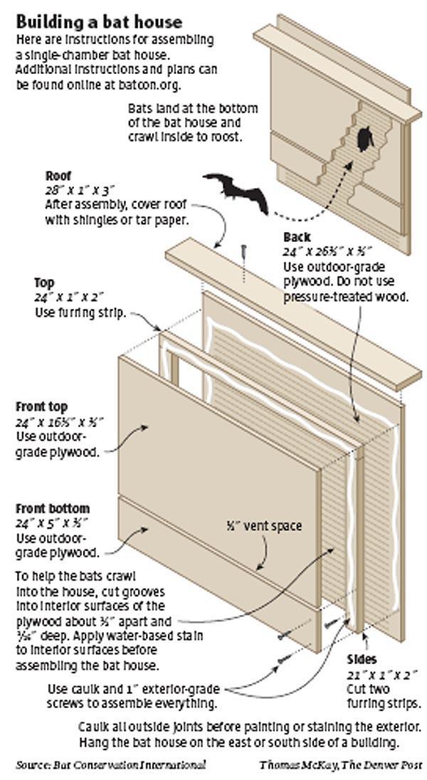
9 the bench, it would be the commission s responsibility to place a plaque recognizing the donors. It is also my recommendation that benches be concreted into their location for sustainability purposes. In the back of this report are blueprints for the ideal style of bench for the Goth Conservancy. Other can be added at your discretion. Bird & Bat Houses To bring in more nature and wildlife and make the journey into the Goth Conservancy enjoyable, it is my recommendation that bird and bat houses are to be built and placed throughout the conservancy. There are currently 10 blue bird houses that a friendly neighbor of the conservancy currently maintains. There are a few other native bird species that I suggest the park commission look into attracting and maintaining their population by building and placing those specific bird houses. The other birds that are native to the Middleton are; house wrens, purple martins, and black-capped chickadees. There are blue-prints in the back of this report that are ideal for each species of bird, these houses are a great Eagle Scout project as well. The other type of flying creature house that I suggest the park commission look into would be bat houses. I understand that the public opinion of bats are often negative, however from a natural and environmental standpoint bats are a great to have in a park. They are natural predators to many annoying insects like mosquitos. By placing bat houses throughout the park and along the various trail systems the individuals who are walking/running/hiking the conservancy will have a much more enjoyable time. As far as location of the bat houses are concerned, it is my recommendation to scatter them along the trail system, roughly feet off the trail. There is a simple bat house blue print in the back of this report. Since both of
10 these are recommended scout projects, it would be the responsibility of the scouts to officially mark out each location. Interpretive Signage The large sign/bulletin board at the main entrance near the parking lot is a great start to signage throughout the conservancy, however the more interpretive signage we have the better informed the public and our visitors will be. Signage throughout the conservancy will also create a welcoming atmosphere. It is my recommendation that the park commission creates educational information about the biomes of the conservancy, like the prairie and woodland areas. Historical signage near the grape arbor, rock amphitheater and entrances to the conservancy. Other signage like Leave No Trace principles will also assist in creating a friendly but yet controlled environment when it comes to cleanliness of the conservancy. A new and improved trail map at both entrances would be ideal, this map would have distances of the different trails along with labeling of the trails. This will allow users to plan out their hike/walk/run as well as future journey through the Goth Conservancy. The southeast entrance into the conservancy from Caribou Ln, needs to be developed with a similar sign that is located at the main entrance of the conservancy. It doesn t need to be as large at the original sign but should include all the same information. I would suggest this also as a scout project and to utilize the same layout and blueprint at the primary sign from the main entrance. There is a history write-up that is placed at the main entrance of the conservancy near the parking lot and shelter. It would be ideal to duplicate the write-up and place it near the rock
11 amphitheater and grape arbor area, since this is a part of the historical aspect of the conservancy. This will allow users to know the history of the land and should instill some sense of responsibility in the user to follow conservancy rules. Speaking of rules, a great tool that many national and state parks use in the Leave No Trace Principles to enforce their rules. Leave No Trace is a fun and professional way to ask visitors to be respectful of the property without coming across as aggressive and forceful. I have taken the time and liberty to address the Leave No Trace Principles that are cohesive with the Goth Conservancy and can be found on a separate page in the back of the report. Marking and mapping the trails is an excellent scout project that can be done relatively easy using a GPS or odometer. The purpose behind having an up to date and user friendly trail map is so that visitors can figure out where they want to go, this will also allow them to plan their trip according to the groups capabilities and time constraints. If visitors know the name of the trail, the distance of the trail, and where scenic locations such as benches, amphitheaters, and grape arbor are they can get the most out of their trip. V. Conclusion I, Nick Harnish have provided the next steps in an evolving Goth Conservancy. Future projects can be completed on an adequate time frame and budget. Utilizing neighbors of the Goth Conservancy, along with local scout troops and the expertise that lie within the park commission, is an ideal situation. It is my hope that the information contained in this report will help Goth Conservancy grow into a wonderful front country location that all visitors near and far will enjoy for years to come.


12 X=Wooden Bench O=Rock Amphitheater +=Stone Bench Goth Conservancy Trail System and Points of Interest Legend W Old Sauk Rd ' Contours Town Maintained Grass Trails Parking Lot M:\Middleton, Town of\ _trails\arcgis\mxd\goth_conservancy_trail_points_of_interest_map_no_symb_clipped_contours_2014_03_06.mxd Trempealeau Trl Trempealeau Trl Prairie Woodland Grape Arbor Prairie Goth Conservancy Prairie O Prairie Woodland Woodland X Prairie X 1154 X Black River Rd Feet Sources: Dane County LIO Town of Middleton Caribou Shelter No Dogs Allowed in Park No Equestrian Access March 6, 2014 ±
13

14 Split Rail Fencing Blueprints
15 Leave No Trace Principles/Rules 1. TRAVEL ON TRAILS Concentrate Activities When Traveling in Heavily Used Areas Land management agencies construct trails in backcountry areas to provide identifiable routes that concentrate foot and stock traffic. Constructed trails are themselves an impact on the land; however, they are a necessary response to the fact that people travel in the back country. Concentrating travel on trails reduces the likelihood that multiple routes will develop and scar the landscape. It is better to have one well-designed route than many poorly chosen paths. Trail use is recommended whenever possible. Encourage travelers to stay within the width of the trail and not short cut trail switchbacks (trail zigzags that climb hill sides). Travelers should provide space for other hikers if taking breaks along the trail. The principles of off-trail travel should be practiced if the decision is made to move off-trail for breaks. (Hikers in the same group should periodically stop to rest and talk. Avoid shouting to communicate while hiking. Loud noises usually are not welcome in natural areas.) 2. DISPOSE OF WASTE PROPERLY Pack it in, pack it out. Inspect your campsite and rest areas for trash or spilled foods. Pack out all trash, leftover food and litter. 3. LEAVE WHAT YOU FIND Allow others a sense of discovery by leaving rocks, plants, archaeological artifacts and other objects of interest as you find them. The activities for this Leave No Trace principle deal with cultural artifacts; however, leave what you find involves many aspects of outdoor use. The following information addresses a variety of ways to respect natural settings. AVOID DAMAGING LIVE TREES AND PLANTS Avoid hammering nails into trees for hanging things, hacking at them with hatchets and saws, or tying tent guy lines to trunks, thus girdling the tree. Carving initials into trees is
16 unacceptable. The cutting of boughs for use as sleeping pads creates minimal benefit and maximum impact. Sleeping pads are available at stores catering to campers. Picking a few flowers does not seem like it would have any great impact and, if only a few flowers were picked, it wouldn't. But, if every visitor thought "I'll just take a few", a much more significant impact might result. Take a picture or sketch the flower instead of picking it. Experienced campers may enjoy an occasional edible plant, but they are careful not to deplete the surviving vegetation or disturb plants that are rare or are slow to reproduce. LEAVE NATURAL OBJECTS AND CULTURAL ARTIFACTS Natural objects of beauty or interest such as antlers, petrified wood, or colored rocks add to the mood of the backcountry and should be left so others can experience a sense of discovery. In National Parks and some other areas it is illegal to remove natural objects. The same ethic is applicable to cultural artifacts found on public land. Cultural artifacts are protected by the Archaeological Resources Protection Act. It is illegal to remove or disturb archeological sites, historic sites, or artifacts such as pot shards, arrowheads, structures, and even antique bottles found on public lands. 4. RESPECT WILDLIFE Learn about wildlife through quiet observation. Do not disturb wildlife or plants just for a "better look". Observe wildlife from a distance so they are not scared or forced to flee. Large groups often cause more damage to the environment and can disturb wildlife so keep your group small. If you have a larger group, divide into smaller groups if possible to minimize your impacts. Quick movements and loud noises are stressful to animals. Travel quietly and do not pursue, feed or force animals to flee. (One exception is in bear country where it is good to make a little noise so as not to startle the bears) In hot or cold weather, disturbance can affect an animal s ability to withstand the rigorous environment. Do not touch, get close to, feed or pick up wild animals. It is stressful to the animal, and it is possible that the animal may harbor rabies or other diseases. Sick or wounded animals can bite, peck or scratch and send you to the hospital. Young animals removed or touched by well-meaning people may cause the animals parents to abandon them. If you find sick animals or animal in trouble, notify a game warden.
17 Considerate hikers observe wildlife from afar, give animals a wide berth, store food securely, and keep garbage and food scraps away from animals. Remember that you are a visitor to their home. 5. BE CONSIDERATE OF OTHER VISITORS One of the most important components of outdoor ethics is to maintain courtesy toward other visitors. It helps everyone enjoy their outdoor experience. Many people come to the outdoors to listen to nature. Excessive noise, unleashed pets and damaged surroundings take away from everyone's experience. So, keep the noise level down while traveling and if you bring a radio, tapes or CDs, use headphones so you will not disturb others. Also keep in mind that the feeling of solitude, especially in open areas, is enhanced when group size is small, contacts are infrequent and behavior is unobtrusive. To maximize your feeling of privacy, avoid trips on holidays and busy weekends or take a trip during the off season. Groups leading or riding livestock have the right-of-way on trails. Hikers and bicyclists should move off the trail to the downhill side. Talk quietly to the riders as they pass, since horses are spooked easily. Take rest breaks on durable surfaces well off the designated trail. Keep in mind that visitors to seldom used places require an extra commitment to travel quietly and lightly on the land. Keep pets under control at all times. Bowser is not in the wildlife category. Dogs running free can be unwelcome, frightening people or leaving behind unwanted "presents". Please pick up dog feces from camps and trails. Some areas prohibit dogs or require them to be on a leash at all times. Leave gates as you find them, and leave the land undisturbed for others to enjoy. Remember, our open spaces and wild lands are protected for all generations. It is up to us to keep them healthy, beautiful and open to the public for recreation, reflection and revitalization! Enjoy and learn from historical and archeological sites but respect these sites and treasures. Some of these are sacred to Native Americans, or are important cultural reminders of our heritage.
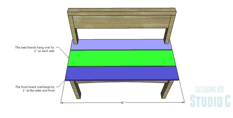
18 DIY Plans to Build a Taboreh Bench Materials: 1-1/2 pocket hole screws 2-1/2 pocket hole screws 1-1/2 nails, screws, or brad nails 3 screws Wood glue Sandpaper (100, 150, 220 grits) Finishing supplies (primer & paint, or stain, sealer) Lumber: at at at at at at 8 Cut List: at 31 Back Legs at 17-1/4 Front Legs at 13 Side Stretchers at 35 Front & Back Stretchers at 13 Seat Supports at 38 Back Top at 35 Back at 40 Seat at 40 Seat
19 Step One Cut the pieces for the back legs. Draw the legs on each of the 2 6 pieces according to the dimensions in the drawing. Cut the legs using a jigsaw or a bandsaw.

20 Step Two Cut the pieces for the front legs and the side stretchers. Draw the arc on the lower edge of the side stretchers and cut with a jigsaw or a bandsaw. Drill pocket holes in each end of each piece with a pocket hole jig set for 1-1/2 material. Secure the side stretchers to the front and back legs using glue and 2-1/2 pocket hole screws.

21 Step Three Cut the pieces for the front and back stretchers. Draw the arc on the lower edge of the front and back stretchers, and cut with a jigsaw or a bandsaw. Drill pocket holes in each end of each piece. Secure the stretchers to the legs (locating the pieces 1 back from the outside edge of the legs) using glue and 2-1/2 pocket hole screws.

22 Step Four Cut the pieces for the seat supports and drill pocket holes in each end. Secure the supports to the front and back stretchers using glue and 2-1/2 pocket hole screws. The top edge of the supports will be flush with the top edge of the stretchers.
23 Step Five Cut the piece for the top back. Position the piece on the top of the back legs securing in place using glue and countersunk 3 screws. Step Six Cut the piece for the back. Set the pocket hole jig for 3/4 material and drill pocket holes in each end as well as one long edge. Secure to the back legs and the underside of the top using glue and 1-1/2 pocket hole screws.

24 Step Seven Cut the pieces for the seat. Cut the notches in one of the 1 6 seat pieces using a jigsaw or a band saw. Secure the board the bench frame using glue and 1-1/2 nails, screws, or brad nails. Secure the remaining seat pieces to the frame using glue and 1-1/2 nails, screws, or brad nails spacing the pieces 1/2 from each other. The pieces will overhang the sides by 1, and the front 1 6 will also overhang the front by 1.
25
26
27
28 How to Move a Full-Grown Grapevine 1. Cut long vines back to within two feet of the ground, making the cuts on the outside of stem nodes. Reduce the number of vines to no more than two or three shoots extending from the main trunk of the grapevine to help with training, to reduce stress on the plant and to help increase fruit production after moving. 2. Insert the point of a shovel in the soil eight to 10 inches from the grapevine trunk. Work the shovel around the vine to create a root ball. Do not allow the roots to dry out during the transplanting process. 3. Dig a hole for the grapevine that is as deep as the root ball and twice as wide. Amend the soil if it is compact or has heavy clay. Incorporate organic material such as peat moss to the soil removed from the hole to add nutrients and assist with drainage. Grapes typically grow best in soil with a ph between 5.0 and Center the grapevine root ball in the hole, and position the top of the root ball so it is at ground level. Add soil around the root ball and tamp it down to remove air pockets; avoid compacting the soil. 5. Water the transplanted grapevine to supplement rainfall and prevent the soil from drying out. Check the soil's moisture by gathering a small handful of dirt and squeezing it. If the dirt crumbles instead of forming together, it needs moisture. If water can be squeezed from the soil, it's too wet. Tips: Choose a training method by the second year of growth after moving the grapevine. Train the transplanted vines as they grow by tying them to an arbor or trellis with string. Allow cut vines to dry to make removal easier. Wear gloves for protection while working. Use dried vines for craft projects such as wreaths. Warnings: Water as needed for the first two years to help the root system of the vine become established. Avoid planting grapevines closer than four feet when training on an arbor and at least eight feet when training on a trellis so the vines and roots have room to grow and spread. Any closer and the vines will fight for climbing space and sunlight.
29 SCOUT PROJECT LIST PARK BENCH CONSTRUCTION & PLACEMENT BIRDHOUSE CONSTRUCTION & PLACEMENT BATHOUSE CONSTRUCTION & PLACMENT PUTTING UP TRAIL MARKERS & MAPPING DISTANCES DEVELOPING THE SOUTHWEST ENTRANCE CREATION OF HABITAT SIGNAGE CONSRTUCTION OF PROPERTY CORNER FENCING ASSISTING WITH PARKING LOT CONFIGURATION*
What to Do What Not to Do
 What to Do What Not to Do Level: Grades K + Time: 45 minutes to an hour depending on number of groups Environment: Indoor or outdoor Size: 2-7 groups of 3-5 Materials: What to do What not to do handout
Backpacking and Hiking LEAVE NO TRACE
 Backpacking and Hiking LEAVE NO TRACE Activity Plan Hiking Series ACTpa014 Project Skills: Learn the seven principles of Leave No Trace (LNT) Develop a skit that demonstrates LNT principles Life Skills:
PIONEER PARK. City of Des Peres Parks Master Plan. SWT Design 46 INTRODUCTION
 PIONEER PARK INTRODUCTION Pioneer Park is a 7 acre neighborhood park located east of Interstate 270 and south of Manchester Road along Tallie Road. The park is situated in a residential neighborhood with
Leave No Trace. Provide ground rules: Note taking is encouraged Handouts at end of presentation Ask questions when you have them S
 Leave No Trace Provide ground rules: Note taking is encouraged Handouts at end of presentation Ask questions when you have them 1A Learning Objectives To emphasize the importance of using Leave No Trace
SEVEN ELEMENTS. Leave No Trace program and Colorado Underground Insider Newsletter
 SEVEN ELEMENTS BY Leave No Trace program and Colorado Underground Insider Newsletter Preface SEVEN ELEMENTS TO CONSIDER WHEN PLANNING A TRIP 1) Identify and record the goals (expectations) of your trip.
Leave No Trace. Prepared for Boy Scout Troop 63 Woodbridge, CT
 Leave No Trace Prepared for Boy Scout Troop 63 Woodbridge, CT What is Leave No Trace? Leave No Trace is a program that evolved from outdoor codes taught by the United States Forest Service, the Bureau
Understanding user expectations And planning for long term sustainability 1
 Understanding user expectations And planning for long term sustainability 1 What is a natural surface trail? It can be as simple has a mineral soil, mulched or graveled pathway, or as developed as elevated
Logo Department Name Agency Organization Organization Address Information 5700 North Sabino Canyon Road
 Logo Department Name Agency Organization Organization Address Information United States Forest Coronado National Forest 5700 North Sabino Canyon Road Department of Service Santa Catalina Ranger District
Leave No Trace Behind. 7 Principles
 Leave No Trace Behind 7 Principles Principle 1: Plan Ahead and Prepare Adequate trip planning and preparation helps backcountry travelers accomplish trip goals safely and enjoyably, while simultaneously
The "Leave No Trace" principles
 The "Leave No Trace" principles Summary Plan Ahead and Prepare - Know the regulations and special concerns for the area you'll visit. - Prepare for extreme weather, hazards, and emergencies. - Schedule
Other Agencies and Organizations
 Daniel Boone National Forest 1700 Bypass Road WInchester, KY 40391 859-745-3100 Location Northern terminus is near Morehead, Kentucky. Southern terminus is located in the Big South Fork NRRA in Tennessee.
Citrus Heights Creek Corridor Trail Project Trail Advisory Group Field Trip #2 September 11, :00 11:00 am Trellis Hall, Citrus Heights
 September 11, 2013 9:00 11:00 am Trellis Hall, Citrus Heights Project Overview The City of Citrus Heights is studying the feasibility of establishing a multi use trail system within the City s 26 miles
City of Durango 5.8 FUNDING TRAILS DEVELOPMENT
 5.8 FUNDING TRAILS DEVELOPMENT The City has been successful in establishing dedicated local funding sources as well as applying for grants to develop the City s trail system, having received nearly $2.4
Langton Lake Park Implementation Planning Session One 6 June Attendees signed in
 27 Attendees signed in Meeting summary Following an overview of the Parks and Recreation Renewal Program and the key directions of the Parks and Recreation System Master Plan, meeting participants were
2. Goals and Policies. The following are the adopted Parks and Trails Goals for Stillwater Township:
 D. PARKS AND TRAILS 1. Introduction Stillwater Township s population is relatively low, with most residents living on rural residences on large lots. The need for active park space has been minimal in
BACKCOUNTRY HORSEMAN OF IDAHO EDUCATION PROGRAM/LNT AN INTRODUCTION TO LEAVE NO TRACE NARRATIVE
 BACKCOUNTRY HORSEMAN OF IDAHO EDUCATION PROGRAM/LNT AN INTRODUCTION TO LEAVE NO TRACE NARRATIVE Backcountry Horsemen is an organization found in 23 states across America. Most people just call us BCH.
LEAVE NO TRACE GIANT BOARD GAME: Intro: Help protect the backcountry. You are a visitor there. When you stay at a friend s house, you wouldn t
 LEAVE NO TRACE GIANT BOARD GAME: Intro: Help protect the backcountry. You are a visitor there. When you stay at a friend s house, you wouldn t trample the flowers, chop down trees, put soap in the drinking
Theme: Predominately natural/natural appearing; rustic improvements to protect resources. Size*: 2,500 + acres Infrastructure**:
 Recreation Opportunity Spectrum (ROS) Classes The Recreation Opportunity Spectrum (ROS) provides a way to describe the variations in the degree of isolation from the sounds and influences of people, and
Welcome to the future of Terwillegar Park a Unique Natural Park
 Welcome to the future of Terwillegar Park a Unique Natural Park 1 Introduction The Terwillegar Park Concept Plan study will develop an overall concept plan, management objectives and development guidelines
Chapter 6: POLICY AND PROCEDURE RECOMMENDATIONS
 Chapter 6 POLICY AND PROCEDURE RECOMMENDATIONS FOR SRRA Below are seven policy elements that should be considered for adoption by the Southwest Regional Recreation Authority of Virginia: 1. Develop strategies
Leave No Trace Leave No Trace activities are directly tied to the tenth spread - pages 19 and 20 of Our Wetland Project.
 Leave No Trace Leave No Trace activities are directly tied to the tenth spread - pages 19 and 20 of Our Wetland Project. e purpose of this lesson is to expose students to responsible backcountry practices
General Rules for Use of Lands Managed by the. Middle Peninsula Chesapeake Bay Public Access Authority
 General Rules for Use of Lands Managed by the Middle Peninsula Chesapeake Bay Public Access Authority As a visitor to lands managed by the Middle Peninsula Chesapeake Bay Public Access Authority (PAA),
Assessing Your Trails, Keeping Them Safe and Enjoyable
 Jon Wood, PLA, ASLA Associate Vice President Stewart Bert Lynn, PLA, ASLA, LEED AP Project Manager Mecklenburg County Asset and Facility Management Assessing Your Trails, Keeping Them Safe and Enjoyable
Silver Lake Park An Environmental Jewel for the Citizens of Prince William County
 Silver Lake Park An Environmental Jewel for the Citizens of Prince William County The Prince William Park Authority Mission Statement states: The Prince William County Park Authority will create quality
A Publication of Friends of Sleeping Bear Dunes
 A Publication of Friends of Sleeping Bear Dunes 2014, Friends of Sleeping Bear Dunes, P.O. Box 545, Empire, MI 49630 www.friendsofsleepingbear.org info@friendsofsleepingbear.org Learn more about the Friends
THOMAS A. SWIFT METROPARK Introductions History Present Conditions Future Development Plans Implementation Strategies Statistics
 THOMAS A. SWIFT METROPARK Introductions History Present Conditions Future Development Plans Implementation Strategies Statistics Introduction As an open meadow park positioned along the Mahoning River,
Table of Contents. page 3 Long term Goals Project Scope Project History. 4 User Groups Defined Trail Representative Committee. 5 Trail Users Breakdown
 Launched April 27th, 2010 1 Table of Contents page 3 Long term Goals Project Scope Project History 4 User Groups Defined Trail Representative Committee 5 Trail Users Breakdown 13 Trail Users Desires 16
BOY SCOUTS OF AMERICA 2016 Wisconsin River District Cub Scout Family Campout Campers Guide
 BOY SCOUTS OF AMERICA 2016 Wisconsin River District Cub Scout Family Campout Campers Guide Our staff appreciates your spirited participation in each event station and during campfire Saturday evening.
esigning Camp and Picnic Units
 Chapter D esigning Camp and Picnic Units Camp units are designed for overnight use and may include a parking pad. Picnic units generally are for day use only. Equestrian camp and picnic units do not have
Lake Wissota Access Locations within the LaFayette Township. By Chad Martin
 Lake Wissota Access Locations within the LaFayette Township By Chad Martin Anson/ Wissota Access Point # 1 Road: 195 th St. Associated Fire Numbers: 13294 Defining Characteristics: Forested from road
Port Gamble Shoreline Area Conceptual Trail Proposal
 The North Kitsap Trails Association is pleased to be a partner to the Kitsap Forest and Bay Project and assist Kitsap County, Forterra, Olympic Property Group, Great Peninsula Conservancy and the Port
Nov. 19 th Public Workshop Summary
 On November 19 th, more than 60 community members attended an Open Space Matters workshop at the Linen Building in downtown Boise for over two hours. Participants learned about reserves, discussed the
Stephens State Park Trails
 TRAILS OF ALLAMUCHY MOUNTAIN & STEPHENS STATE PARKS Allamuchy Mountain and Stephens State Parks contain 28 marked trails providing access to diverse landscapes for walking, hiking, biking, bird-watching,
Clearwater Lake Provincial Park. Draft Management Plan
 Clearwater Lake Provincial Park Draft Management Plan Clearwater Lake Provincial Park Draft Management Plan Table of Contents 1. Introduction... 3 2. Park History... 4 3. Park Attributes... 4 3.1 Location/Access...4
Subj: POLICY FOR MAINSIDE TRAIL USE AT MARINE CORPS BASE QUANTICO
 UNITED STATES MARINE CORPS MARINE CORPS BASE QUANTICO, VIRGINIA 22134-5001 MCBO 5090.4 B 04 MARINE CORPS BASE ORDER 5090.4 From: Commander To: Distribution List Subj: POLICY FOR MAINSIDE TRAIL USE AT MARINE
Flow Stand Up Paddle Board Parkway Plan Analysis
 Regional Parks Department Jeffrey R. Leatherman, Director County of Sacramento Divisions Administration Golf Leisure Services Maintenance Rangers Therapeutic Recreation Services Flow Stand Up Paddle Board
NEW MEADOWS PARK PROPOSED MASTER PLAN
 NEW MEADOWS PARK PROPOSED MASTER PLAN A vision for your neighborhood park, the draft master plan is ready for your review. Tuesday September 12 th, 2017 5:30-7:00 PM Hellgate School District #4 middle
DRAFT. Dorabelle Campground Rehabilitation
 DRAFT Dorabelle Campground Rehabilitation September 2012 1.1 REGIONAL SETTING AND PROJECT LOCATION The Dorabelle Campground is located on the western shore of Shaver Lake in Fresno County, California (Section
NATURE OUTOOR PROGRAM PIE PATCH
 NATURE OUTOOR PROGRAM PIE PATCH Available only at MVSR 1. In GOLD PANNING, you will learn how to pan, how to use a High banker, and how to use a 2 dredge. You will learn how and where to look for gold.
The 7 Principles of Leave No Trace.
 Leave No Trace Leave No Trace, Inc. www.lnt.org The Leave No Trace educational program was organized in 1991 in conjunction with the U.S. Forest Service, National Outdoor Leadership School (NOLS) and the
ANAGEMENT. LAN November, 1996
 M ANAGEMENT P LAN November, 1996 for Paul Lake Provincial Park Ministry of Environment, Lands and Parks BC Parks Department Paul Lake Provincial Park M ANAGEMENT P LAN Prepared by BC Parks Kamloops Area
FINAL TESTIMONY 1 COMMITTEE ON RESOURCES UNITED STATES HOUSE OF REPRESENTATIVES. July 13, 2005 CONCERNING. Motorized Recreational Use of Federal Lands
 FINAL TESTIMONY 1 STATEMENT OF DALE BOSWORTH CHIEF Of the FOREST SERVICE UNITED STATES DEPARTMENT OF AGRICULTURE Before the SUBCOMMITTEE ON FORESTS AND FOREST HEALTH And the SUBCOMMITTEE ON NATIONAL PARKS,
Eco Explorer. Steps. Purpose
 Eco Explorer A n eco explorer is a person who investigates environmental issues and works to make positive changes to the environment. In this badge, you ll be an eco explorer as you take a look at different
The Frank Church River of No Return Wilderness
 ALLIANCE FOR WILDERNESS EDUCATION AND STEWARDSHIP PO Box 2667, Bellingham, WA 98227-2667 Tele: 360-927-1804 Fax: 360-527-9679 bradt@wildernessalliance.org www.wildernessalliance.org STEWARDS OF AMERICA
Occoneechee Council Holiday 50 Miler
 Occoneechee Council Holiday 50 Miler December 26-31, 2018 update 8/10/18 8:50pm Come join us for the Occoneechee Council Holiday 50 Miler at Yates Place Camp Ground in Uwharrie National Forest. This trek
EXECUTIVE SUMMARY PROGRAM DEVELOPMENT REPORT PURPOSE EXISTING SETTING EXPANDING PARKLAND
 EXECUTIVE SUMMARY PROGRAM DEVELOPMENT REPORT PURPOSE As the culmination of the first phase of the master planning process, this Program Development Report creates the framework to develop the Calero County
Blueways: Rivers, lakes, or streams with public access for recreation that includes fishing, nature observation, and opportunities for boating.
 Parks, Open Space and Trails PRINCE WILLIAM COUNTY 2008 COMPREHENSIVE PLAN TRAILS PLAN CONTENTS The components of the trails plan are: Intent Definitions Goals, Policies, and Action Strategies Trails Map
Wilderness Research. in Alaska s National Parks. Scientists: Heading to the Alaska Wilderness? Introduction
 Wilderness Research in Alaska s National Parks National Park Service U.S. Department of Interior Scientists: Heading to the Alaska Wilderness? Archeologist conducts fieldwork in Gates of the Arctic National
East Carolina Council Facility Study East Carolina Scout Reservation Camp Boddie Pamlico Sea Base
 East Carolina Council Facility Study East Carolina Scout Reservation Camp Boddie Pamlico Sea Base 1 VISION OF CAMP BODDIE EAST CAROLINA SCOUT RESERVATION 1. Attract Out Of Council Troops Use our natural
What are you getting into?
 Overnight Camping What are you getting into? You will be hiking with your gear to a campground about ½ mile away and spending 1 night camping You will help to prepare a meal over an open flame You will
LESSON 9 Recognizing Recreational Benefits of Wilderness
 LESSON 9 Recognizing Recreational Benefits of Wilderness Objectives: Students will: study, analyze, and compare recreation visitor days (RVD s) for Wilderness areas adjacent to their homes or nearest state,
RE: Access Fund Comments on Yosemite National Park Wilderness Stewardship Plan, Preliminary Ideas and Concepts
 September 30, 2016 Superintendent Yosemite National Park Attn: Wilderness Stewardship Plan P.O. Box 577 Yosemite, CA 95389 RE: Access Fund Comments on Yosemite National Park Wilderness Stewardship Plan,
Santa Clara South Hills Recreation Park Project Development and Management Plan
 Santa Clara South Hills Recreation Park Project Application for Land for Recreation or Public Purposes, City of Santa Clara, Utah Prepared for: Bureau of Land Management, St. George Field Office 345 East
Chuckanut Ridge Fairhaven Highlands EIS Scoping Concerns
 Chuckanut Ridge Fairhaven Highlands EIS Scoping Concerns Coalition of Southside Neighborhoods CSN Comments for Fairhaven Highlands EIS Scope Hearing, Jan 16, 2008 1 Chuckanut Ridge Hilly Terrain: Potential
DAKOTA CULTURE UPPER SIOUX COMMUNITY: AREA CHARACTER ANALYSIS ALIGNMENT STRATEGY
 UPPER SIOUX COMMUNITY: AREA CHARACTER ANALYSIS ALIGNMENT STRATEGY 51 AREA CHARACTER ANALYSIS: OPPORTUNITIES & CONSTRAINTS RECREATIONAL VEHICLE PARK: A recreational vehicle park will be built to accommodate
Understanding the caring capacity of the visitor experience Provide facilities to support a high level user experience Address visual quality through
 Understanding the caring capacity of the visitor experience Provide facilities to support a high level user experience Address visual quality through recreation ecological restoration opportunities Collaboration
ADOPT-A-TRAIL MANUAL C. Bailey-May
 ADOPT-A-TRAIL MANUAL C. Bailey-May 2011 1 ADOPT-A-TRAIL VOLUNTEER DUTIES Welcome to the White Mountain National Forest s Adopt-A-Trail (AAT) program and thank you for volunteering with us! This volunteer
MORGAN CREEK GREENWAY Final Report APPENDICES
 APPENDICES MORGAN CREEK GREENWAY Appendix A Photos of Existing Conditions in Trail Corridor Photos of existing conditions Main trail corridor - February 2009 Photos of existing conditions south bank Morgan
Tracy Ridge Shared Use Trails and Plan Amendment Project
 Tracy Ridge Shared Use Trails and Plan Amendment Project Scoping Document Forest Service Allegheny National Forest Bradford Ranger District McKean, County, Pennsylvania In accordance with Federal civil
Good Neighbour Guide A guide to being a good neighbour in Peachland
 District of Peachland Good Neighbour Guide A guide to being a good neighbour in Peachland 1 Introduction to the Guide Good neighbours make great neighbourhoods. We each play a role in enhancing our neighbourhoods
Dungeness Recreation Area County Park Master Plan
 Dungeness Recreation Area County Park Public Outreach Meeting October 10, 2007 Project Overview USFWS Site Dungeness Recreation Area County Park Meeting Objectives: Re-Introduce project; provide status
Park Activity Book. Start your adventure with Buddy Bison. Explore outdoors, the parks are yours!
 Park Activity Book Start your adventure with Buddy Bison. Explore outdoors, the parks are yours! National Park Trust www.parktrust.org Park Adventure Booklet Visit www.buddybison.org to get your own Buddy
APPENDIX D: SUSTAINABLE TRAIL DESIGN. APPENDICES Town of Chili Parks and Recreation Master Plan Update
 APPENDIX D: SUSTAINABLE TRAIL DESIGN APPENDICES Town of Chili Parks and Recreation Master Plan Update Sustainable Trail Construction Sustainable trails are defined by the US Forest Service as trails having
Procedure for the Use of Power-Driven Mobility Devices on Mass Audubon Sanctuaries 1 September 17, 2012
 Procedure for the Use of Power-Driven Mobility Devices on Mass Audubon Sanctuaries 1 September 17, 2012 Background As part of Mass Audubon s mission to preserve the nature of Massachusetts for people and
Bigfoot s Playbook Activity Materials
 Bigfoot s Playbook Activity Materials The following activitiy materials are intended to be used with Bigfoot s Playbook: A Youth Educator s Guide to Leave No Trace Activities, Games, and Experiential Curriculum.
National Recreation Trail Update Form
 National Recreation Trail Update Form Introduction Thank you for taking the time to complete this form. Your assistance will help ensure that the National Recreation Trail (NRT) database is complete and
Managing Informal Trail Impacts. Jeff Marion, Unit Leader/Scientist Virginia Tech Field Unit, USGS, Patuxent WRC
 Managing Informal Trail Impacts Jeff Marion, Unit Leader/Scientist Virginia Tech Field Unit, USGS, Patuxent WRC jmarion@vt.edu, 540-231-6603 Presentation Objectives Informal Trail Management!! Decision
2. STAKEHOLDER FEEDBACK // What We Heard
 1. QUARRY ROAD TRAIL // Welcome to the Information Session PROJECT DESCRIPTION WHY WE ARE HERE Quarry Road Trail is a popular commuter trail and recreational area for Calgarians. 1. To report citizen feedback
Potomac Gorge. Resource Booklet. A Natural Monument in the Shadow of National Monuments. Bridging the Watershed. Potomac Gorge 75
 Potomac Gorge Potomac Gorge A Natural Monument in the Shadow of National Monuments Resource Booklet Bridging the Watershed An outreach program of the Alice Ferguson Foundation in partnership with the National
Cedars RV Resort Owners Handbook. Phases 1,2,3
 Cedars RV Resort Owners Handbook Phases 1,2,3 NOTICE TO READER This document can and will evolve over time. Every effort has been made to provide simple clarity to common topics requiring definition. Should
National Recreation Trail Application for Designation
 National Recreation Trail Application for Designation Introduction Thank you for your interest in the National Recreation Trail (NRT) program. Completed NRT application packages must be submitted by December
National Forests and Grasslands in Texas
 United States Department of Agriculture Forest Service National Forests and Grasslands in Texas Sam Houston NF 394 FM 1375 West New Waverly, Texas 77358 Phone 936-344-6205 Dear Friends, File Code: 1950
AGENDA ITEM 5 D WAKULLA ENVIRONMENTAL INSTITUTE (WEI) TRAIL FEASIBILITY STUDY
 TRAIL FEASIBILITY STUDY") March 19, 2018 AGENDA ITEM 5 D WAKULLA ENVIRONMENTAL INSTITUTE (WEI) TRAIL FEASIBILITY STUDY TYPE OF ITEM: Action STATEMENT OF ISSUE The Wakulla Environmental Institute (WEI) Trail is one of several trails
March 19, 2018 AGENDA ITEM 5 D WAKULLA ENVIRONMENTAL INSTITUTE (WEI) TRAIL FEASIBILITY STUDY TYPE OF ITEM: Action STATEMENT OF ISSUE The Wakulla Environmental Institute (WEI) Trail is one of several trails
Archaeology Internship in the Great Smoky Mountains National Park Summer 2010, Leila Donn
 Archaeology Internship in the Great Smoky Mountains National Park Summer 2010, Leila Donn This past summer I spent three months working as an archaeology intern in the Great Smoky Mountains National Park
Marchand Provincial Park. Management Plan
 Marchand Provincial Park Management Plan 2 Marchand Provincial Park Table of Contents 1. Introduction... 3 2. Park History... 3 3. Park Attributes... 4 3.1 Natural... 4 3.2 Recreational... 4 3.3 Additional
Sasagiu Rapids Provincial Park. Draft Management Plan
 Sasagiu Rapids Provincial Park Draft Management Plan 2 Sasagiu Rapids Provincial Park Table of Contents 1. Introduction... 3 2. Background and Park Attributes... 3 2.1 Park History.... 3 2.2 Natural Features...
IOWA ORNITHOLOGISTS' UNION - Birding Sites in Dallas County
 IOWA ORNITHOLOGISTS' UNION - Birding Sites in Dallas County Printed on 7/19/2018 Beaver Bottoms Wetland (restricted) (Important Bird Area) GPS Coordinates:, Ownership: Private (see directions for access)
American Conservation Experience
 ACE Project Report For Tonto National Forest, Arizona Trail Association and Arizona State Parks Title of Project: 4 Peaks Trail Maintenance Award Contract Number: ASP NM11021 Project Partner: Paul Burghard
WAIPU COVE RESERVE BOARD POLICY DOCUMENT ANNUAL SITE DEVELOPMENT REGULATIONS
 WAIPU COVE RESERVE BOARD POLICY DOCUMENT ANNUAL SITE DEVELOPMENT REGULATIONS This signed document, along with a plan and detail of any proposed works, must be submitted for approval to the board via management
Lewis River Recreation Sites
 Lewis River Recreation Sites Parking Fees Hours Visitors entering day-use sites with vehicles must pay applicable fees during peak recreation season. * Pass holders, please check in with booth attendant
Preferred Recreation Recommendations Stemilt-Squilchuck Recreation Plan March 2018
 Preferred Recreation Recommendations Stemilt-Squilchuck Recreation Plan March 2018 Below are the recommended recreation ideas and strategies that package together the various recreation concepts compiled
Wooden Koi/Octagonal Pond Instruction Manual
 www.gardenparadise.net Wooden Koi/Octagonal Pond Instruction Manual Introduction Please take time to read these instructions prior to installing your pond. This will help you understand the product and
SUMMERCAMPSTAFF JOB DESCRIPTIONS
 SUMMERCAMPSTAFF JOB DESCRIPTIONS 2018 Job Descriptions Camp Director Reports to: Scout Executive, Council Program Specialist. Responsible adult over 25, previous camp staff experience, National Camp School
A Guide to Trail Etiquette
 Share Our Trails A guide to Trail Etiquette Page 12 www.garlic.com/~lbha lbha@vfr.net P.O. Box 2326 Loomis CA 95650 Page Sharing Our Trails A Guide to Trail Etiquette NON-PROFIT U.S. POSTAGE PAID Loomis,
A link to heritage by connecting the community to its history.
 In March 2015 the Board of Sentiers Chelsea Trails asked Chelsea Council to explore the feasibility of converting the winter rail corridor trail into a 4 season, non-motorized, multi-purpose trail. To
Fossil Creek Wild & Scenic River Comprehensive River Management Plan Forest Service Proposed Action - details March 28, 2011
 Fossil Creek Wild & Scenic River Comprehensive River Management Plan Forest Service Proposed Action - details March 28, 2011 Primary Goals of the Proposed Action 1. Maintain or enhance ORVs primarily by
Cub Scout Den Meeting Outline
 Cub Scout Den Meeting Outline Month: April Week: 2 Point of the Scout Law: Thrifty Before the Meeting Gathering Opening Discussion Activity Business items/take home Closing After the meeting Tiger Wolf
Trail # NW Tuesday, June DESIGN. Provide an Review the Provide an. Project Goals: System system. wayfinding
 I. Welcome / Introductions Bethany Creek Trail #2 Segment 3 Neighborhood Meeting #1 Bethany Presbyterian Church 15505 NW Springville Road, Portland, OR 97229 Tuesday, June 26, 2018 @ 6:00PM Meeting Minutes
THAT the Board approve the final proposed concept plan for the Jericho Marginal Wharf site as shown in Figure C-4 of Appendix C.
 Date: January 17, 2012 TO: Board Members Vancouver Park Board FROM: General Manager Parks and Recreation SUBJECT: Jericho Marginal Wharf Phase 2 Concept Plan RECOMMENDATION THAT the Board approve the final
Axe and Saw Permit: Safe Use of Axes
 Page 1 of 7 Objective: The objective of this workshop guide is for the Scout Leader and/or Scout youth to be able to describe and demonstrate safe use of the Axe. Axe or Hatchet: What s the difference?
ETOBICOKE CREEK NORTH TRAIL PROJECT. May 18, 2017 at Michael Power High School 105 Eringate Drive, Etobicoke ON M9C 3Z7
 ETOBICOKE CREEK NORTH TRAIL PROJECT May 18, 2017 at Michael Power High School 105 Eringate Drive, Etobicoke ON M9C 3Z7 1 Purpose of Open House The purpose of today s open house is to present the design
(/ 12 (/ 18 (/ 18 (/ 12 (/ 51 (/ 14 Æ%106 Æ% 106 Æ% 213 Æ% 104 Æ% 89 Æ% 26 Æ% 73 Æ% 59 Æ% 138 Æ% 92 Æ% 26 Æ% 67 Æ% 11 Æ% 11 Æ% 11. Æÿ H Æÿ Z.
 WAUKESHA Existing Ice Age Trail, subject to change as it evolves toward completion Glacial Drumlin Rail-Trail 94 Ice Age Trail Rock, Walworth and Jefferson Counties Other Trail Unofficial Connecting Route
Mt. Hood National Forest
 United States Department of Agriculture Forest Service Mt. Hood National Forest Zigzag Ranger District 70220 E. Highway 26 Zigzag, OR 97049 503-622-3191 Fax: 503-622-5622 File Code: 1950-1 Date: June 29,
MIDDLE SCHOOL CURRICULUM TR AILING ICE AGE M YST ERI E S ICE AGE TREKKING
 MIDDLE SCHOOL CURRICULUM TR AILING ICE AGE M YST ERI E S ICE AGE TREKKING CONTENTS I. Enduring Knowledge... 3 II. Teacher Background... 3 III. Before Viewing this Video... 5 IV. Viewing Guide... 5 V. Discussion
Form for Project Descriptions - December 2013 version! 1. Stone Valley Cooperative Recreation Area (SVCRA) Project Description
 Project Description") Form for Project Descriptions - December 2013 version 1 Stone Valley Cooperative Recreation Area (SVCRA) Project Description The Stone Valley partners request that proposed work on land within the SVCRA
Form for Project Descriptions - December 2013 version 1 Stone Valley Cooperative Recreation Area (SVCRA) Project Description The Stone Valley partners request that proposed work on land within the SVCRA
Trail Etiquette. Hours of Operation. Trail Accessibility
 Trail Guide The Elmhurst Park District, with 28 parks and over 460 acres of land, offers nearly six miles of paved or asphalt park trails and maintains an additional 3.6 miles of trails within Elmhurst.
The Roots of Carrying Capacity
 1 Applying Carrying Capacity Concepts in Wilderness 1872 1964...shall be preserved for the use & enjoyment of the American people...in such manner as will leave them unimpaired for future generations...
Preparing for A Crew Expedition
 Preparing for A Crew Expedition A Venture Scout Crew Expedition looks something like: A crew hiking (or walking, cycling, sailing) and camping independently A Crew Leader and an Assistant Crew Leader leading
West Point Project U.S. Army Corps of Engineers VOLUNTEER VACANCY ANNOUNCEMENT Posted: 1/12/2018
 West Point Project U.S. Army Corps of Engineers VOLUNTEER VACANCY ANNOUNCEMENT Posted: 1/12/2018 Current Volunteer Coordinator: Park Ranger Rebecca Downey Rebecca.m.downey@usace.army.mil 706-645-6113 West
Section 61 Recreational Vehicle Park / Campground (Bylaw No. 2012/10)
") Part 7 General Regulations Section 61 Recreational Vehicle Park / Campground (Bylaw No. 2012/10) 61.1 A comprehensive site plan shall be provided to the satisfaction of the Development Authority that shows
Part 7 General Regulations Section 61 Recreational Vehicle Park / Campground (Bylaw No. 2012/10) 61.1 A comprehensive site plan shall be provided to the satisfaction of the Development Authority that shows