Managing Informal Trail Impacts. Jeff Marion, Unit Leader/Scientist Virginia Tech Field Unit, USGS, Patuxent WRC
|
|
|
- Theodora Crawford
- 5 years ago
- Views:
Transcription

1 Managing Informal Trail Impacts Jeff Marion, Unit Leader/Scientist Virginia Tech Field Unit, USGS, Patuxent WRC
2 Presentation Objectives Informal Trail Management!! Decision Process!! Inventory & Monitoring!! Visitor Education (Leave No Trace practices)!! Site Management!! Research Studies

3 Informal Trail Management: A Decision Process!! Problem Description Collect Inventory & Monitoring Data!! Evaluate Impact Acceptability!! Evaluate Causes and Alternative Solutions!! Apply Site and/or Visitor Management Actions


4 Trail Survey Results Formal Informal mi mi
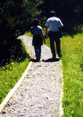
5 Shenandoah National Park
6 Shenandoah National Park
7 Informal Trail Management!! Problem Description - Collect Inventory & Monitoring Data!! Evaluate Impact Acceptability!! Evaluate Causes and Alternative Solutions!! Site Management!! Visitor Management
8 Evaluate Impact Acceptability!!Consider the management zone and objectives:!! Impacts are less acceptable in pristine areas than in developed areas.!!consider resource sensitivity:!! Impacts are less acceptable when they affect R,T & E species or cultural resources.!! Design attributes related to resistance (e.g., grade).!!consider use-related factors:!! Appropriateness of type, amount, or location of use.!! User-behavior (e.g., short-cuts)


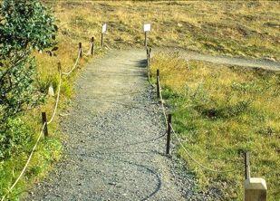
9 Management Zone Acadia NP, Little Moose Island Natural Zone
10 Informal trails on Little Moose Island, Acadia NP Condition Class Length (ft) Percent Condition Class Description 0 3, , , , Trail barely distinguishable; no or minimal disturbance of vegetation and/or organic litter. Trail distinguishable; slight loss of veg cover and/or minimal disturbance of organic litter. Trail obvious; vegetation cover lost or disturbed. Vegetation cover lost and organic litter lost in nearly all places, but little or no erosion. Soil erosion or compaction in tread is beginning in some places. Soil erosion or compaction is common; tread is obviously below ground surface.

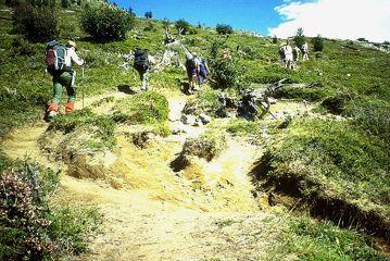
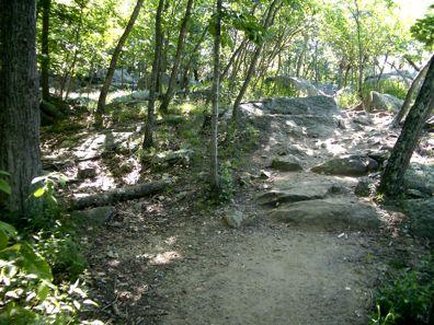
11 Resource Sensitivity Informal trails are more susceptible to impacts due to:!! Steep grades!! Fall line alignments!! Lack of construction!! Lack of maintenance Shenandoah NP


12 Low Alignment angle High Alignment angle
13 Informal Trail Management!! Problem Description - Collect Inventory & Monitoring Data!! Evaluate Impact Acceptability!! Evaluate Causes and Alternative Solutions!! Site Management!! Visitor Management

14 Evaluate Causes Field Assessment

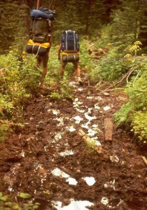
15 Evaluate Causes: Results from a Visitor Survey Reasons for hiking off trail Percent To get to a scenic vista or area of interest 45.1 To move past others on the trail 39.5 Because there was an unmarked trail that already existed 38.8 To explore 34.7 Accidentally because the trail was poorly marked 33.9 To get around a difficult part of the trail 30.2 To get away from crowds on the trail 28.8 To get around poor trail conditions 28.4 To take a picture 20.6 To get to a rock climbing spot 15.7 To get to a picnic spot 12.2 To view wildlife/birds 11.5 To take a route you always use 9.4 To view wildflowers 7.7 To get to a fishing spot 0.7
16 Evaluate Alternative Solutions!! No action needed for trails found to be acceptable - consider basic management:!!limited maintenance of tread/vegetation!!reroute non-sustainable/problem sections!! Close trails with unacceptable impacts, from illegal uses, and those representing avoidable impact.!! Implement actions and monitoring as part of an adaptive management program. Use a phased approach that applies indirect to more direct actions.!! Integrated site management and educational actions are always more effective than single actions.
17 Informal Trail Management!!Site Management!!Improve Management of Formal Trails!!Close & Restore Unacceptable Trails!!Evaluate/Redesign Trails Left Open!!Maintain Trails
18 Improve Management of Formal Trails!! Improve blazing!! Improve tread!! Add trail borders or fencing


19 Close & Restore Unacceptable Trails!! Close unacceptable informal trails!! Implement restoration work where possible

20 Evaluate/Redesign Trails Left Open For informal trails left open:!! Evaluate the sustainability of alignments!! Consider reroutes of non-sustainable sections!! Consider designation as formal trails

21 Maintain Informal Trails For informal trails left open:!! Consider minimal maintenance work where needed (e.g., influence route by rearranging large rocks to protect rare plants or prevent soil erosion)
22 Informal Trail Management!!Visitor Management!!Education Leave No Trace Practices!!Regulation
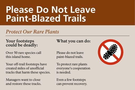
23 Visitor Education Visitor Education ensure that visitors are aware that:!! off-trail trampling impacts are a problem,!! remaining on formal trails protects park resources,!! all formal trails are blazed/marked. Visitor Regulation ensures that visitors know:!! when off-trail hiking is permitted, discouraged, or prohibited.


24 Educational Messages:!! should clearly specify low impact behaviors,!! should provide a rationale when possible,!! Attribution message: Your feet have trampled the vegetation on this island. Please stay on the blazed formal trails!! Injunctive-proscriptive message: Please don't go off the designated trails in order to protect the rare vegetation in this park


25 Education Leave No Trace Practices Travel on Durable Surfaces:!! Formal Trails!! Established informal trails (when appropriate)!! Rock/snow!! Naturally exposed sand/soil!! Grasses!! Organic litter


26 Regulation!!Establish regulations and install signage stating that off-trail traffic is prohibited.
27 Research: Education & Site Management!! Effective educational messages:!! Sanction (Swearingen & Johnson, 1994 & 1992)!! Attribution (Bradford & McIntyre, 2007)!! Injunctive-Proscriptive (Winter, 2005)!! Importance of sign location (Bradford & McIntyre, 2007)!! Uniformed employees often as effective as educational signs (Widner & Roggenbuck, 2000)!! Barriers in combination with signs (Park et al, 2008);

28 Research: Potomac Gorge, Bear Island Bear Island is the focus of this research!! 96 acres!! Home to over 50 of Maryland s R,T&E species!! Co-owned by the NPS & The Nature Conservancy!! Billy Goat Trail, Section A!! Formal trails = 3.5 mi; informal trails = 9.5 mi!! Very high visitation, 2000 hikers on some weekends
29 Research Studies <! Additive treatments <! Unobtrusive observation!! Intensive blazing!! Formalized side vista trails!! Trailhead educational signage!! Prompter signage at informal!! trailheads!! Informal trail brushing!! Symbolic fencing!! Informal trail site restoration!! Personal contact!! Threats: Stay on Trail Unexploded Ordinance
30
31
32

33
34 Research Results Treatment Stayed On-Trail Went Off-Trail Control 1899, 75.3% 623, 24.7% Prompter 2303, 93.1% 171, 6.9% Brushing 2205, 98.0% 44, 2.0% Restoration 466, 97.1% 14, 2.9% Stewards 182, 100.0% 0, 0.0%
Guidance for Managing Informal Trails
 Jeff Marion, USGS Research Scientist (jmarion@vt.edu, 540-231-6603) The development, deterioration and proliferation of visitor-created informal trails in protected areas can be a vexing management issue
SEGMENT ASSESSMENT REPORT
 2017 SEGMENT ASSESSMENT REPORT SEGMENT 3: MT ROSE / TAHOE MEADOWS TO SPOONER SUMMIT REPORT SUMMARY This report is a compilation of information collected on the Tahoe Rim Trail during assessments performed
Theme: Predominately natural/natural appearing; rustic improvements to protect resources. Size*: 2,500 + acres Infrastructure**:
 Recreation Opportunity Spectrum (ROS) Classes The Recreation Opportunity Spectrum (ROS) provides a way to describe the variations in the degree of isolation from the sounds and influences of people, and
Logo Department Name Agency Organization Organization Address Information 5700 North Sabino Canyon Road
 Logo Department Name Agency Organization Organization Address Information United States Forest Coronado National Forest 5700 North Sabino Canyon Road Department of Service Santa Catalina Ranger District
Acadia National Park. Waterman Fund Grant Report 2016 Cadillac Mountain South Ridge Trail Rehabilitation. Acadia National Park
 Acadia National Park National Park Service U.S. Department of the Interior Natio n alpar kser vic e U. S. Depar tm en t o f the In ter io r Waterman Fund Grant Report 2016 Cadillac Mountain South Ridge
Tracy A. Farrell Jeffrey L. Marion. Solitude at the Wilderness Campsite
 Camping Impact Management at Isle Royale National Park: An Evaluation of Visitor Activity Containment Policies From the Perspective of Social Conditions Tracy A. Farrell Jeffrey L. Marion Abstract A survey
Fossil Creek Wild & Scenic River Comprehensive River Management Plan Forest Service Proposed Action - details March 28, 2011
 Fossil Creek Wild & Scenic River Comprehensive River Management Plan Forest Service Proposed Action - details March 28, 2011 Primary Goals of the Proposed Action 1. Maintain or enhance ORVs primarily by
Appalachian Trail Sustainability Research Study
 Appalachian Trail Sustainability Research Study Appalachian National Scenic Trail 2,175 mile footpath from Maine to Georgia Crosses 14 states, 6 NPS units, and 8 National Forests, Managed by the NPS A.T.
DATE: 23 March, 2011 TO: Communities FROM: BlazeSports America. RE: Accessible Trails Checklist 1
 M E M O R A N D U M DATE: 23 March, 2011 TO: Communities FROM: BlazeSports America RE: Accessible Trails Checklist 1 The purpose of the Accessible Trails Checklist (below) is to help the community review
Appendix A Appendix A (Project Specifications) Auk Auk / Black Diamond (Trail 44) Reroute
 Auk Auk / Black Diamond (Trail 44) Reroute") Appendix A (Project Specifications) Auk Auk / Black Diamond (Trail 44) Reroute I. Proposed Action: This project proposes to reroute approximately 1,800 feet of a 50 inch wide trail, off of private property
Appendix A (Project Specifications) Auk Auk / Black Diamond (Trail 44) Reroute I. Proposed Action: This project proposes to reroute approximately 1,800 feet of a 50 inch wide trail, off of private property
Non-motorized Trail Plan & Proposal. August 8, 2014
 Town of Star Valley Ranch, Wyoming and the Star Valley Ranch Association in partnership with the USDA Forest Service, Bridger-Teton National Forest, Greys River Ranger District Non-motorized Trail Plan
ROAD AND TRAIL PROJECT APPROVAL
 ROAD AND TRAIL PROJECT APPROVAL www.marincountyparks.org Marin County Parks, 3501 Civic Center Dr, Suite 260, San Rafael, CA 94903 DATE: July 12, 2017 PRESERVE: Gary Giacomini Open Space Preserve PROJECT:
Volunteer Project Trip Report Yosemite National Park May 16-20, 2012
 Conservation Volunteers International Program 120 Village Square #9 Orinda, California 94563 USA www.conservationvip.org A Non-Profit 501c3 Tax Exempt Organization CST 2089890-40 Volunteer Project Trip
Maryland State Parks Diversity and Inclusion Efforts: Staff Perspectives and Media Reporting
 Maryland State Parks Diversity and Inclusion Efforts: Staff Perspectives and Media Reporting Natalia Buta, Ph.D. Associate Professor, Frostburg State University University System of Maryland Objectives
APPENDIX D: SUSTAINABLE TRAIL DESIGN. APPENDICES Town of Chili Parks and Recreation Master Plan Update
 APPENDIX D: SUSTAINABLE TRAIL DESIGN APPENDICES Town of Chili Parks and Recreation Master Plan Update Sustainable Trail Construction Sustainable trails are defined by the US Forest Service as trails having
FORMAL AND INFORMAL TRAIL MONITORING PROTOCOLS AND BASELINE CONDITIONS: GREAT FALLS PARK AND POTOMAC GORGE. Final Report
 RESEARCH REPORT USDI, U.S. Geological Survey FORMAL AND INFORMAL TRAIL MONITORING PROTOCOLS AND BASELINE CONDITIONS: GREAT FALLS PARK AND POTOMAC GORGE Final Report Distributed by: Virginia Tech, College
INTRODUCTION. Mailing address: Burke County Community Development Attn: Tim Johnson P. O. Box 219 Morganton, NC
 REQUEST FOR QUALIFICATIONS: PROFESSIONAL, EXPERIENCED TRAIL BUILDERS FOR THE CONSTRUCTION OF THE FONTA FLORA STATE TRAIL LAKE JAMES SECTION BURKE COUNTY COMMUNITY DEVELOPMENT INTRODUCTION Burke County
Preferred Recreation Recommendations Stemilt-Squilchuck Recreation Plan March 2018
 Preferred Recreation Recommendations Stemilt-Squilchuck Recreation Plan March 2018 Below are the recommended recreation ideas and strategies that package together the various recreation concepts compiled
Williamson Rock/Pacific Crest National Scenic Trail (PCT) Project EIS. Notice of intent to prepare an Environmental Impact Statement.
 Project EIS. Notice of intent to prepare an Environmental Impact Statement.") [3411-15-P] DEPARTMENT OF AGRICULTURE Forest Service Angeles National Forest; Los Angeles County, CA Williamson Rock/Pacific Crest National Scenic Trail (PCT) Project EIS AGENCY: ACTION: Forest Service,
[3411-15-P] DEPARTMENT OF AGRICULTURE Forest Service Angeles National Forest; Los Angeles County, CA Williamson Rock/Pacific Crest National Scenic Trail (PCT) Project EIS AGENCY: ACTION: Forest Service,
Kicking the Alpine Plants Out Mountain Goat Wallows In Mount Peale Research Natural Area (La Sal Mountains, Utah)
") Kicking the Alpine Plants Out Mountain Goat Wallows In Mount Peale Research Natural Area (La Sal Mountains, Utah) Marc Coles-Ritchie, Grand Canyon Trust November 21, 2017 Mountain goats are digging up
Kicking the Alpine Plants Out Mountain Goat Wallows In Mount Peale Research Natural Area (La Sal Mountains, Utah) Marc Coles-Ritchie, Grand Canyon Trust November 21, 2017 Mountain goats are digging up
The 7 Principles of Leave No Trace.
 Leave No Trace Leave No Trace, Inc. www.lnt.org The Leave No Trace educational program was organized in 1991 in conjunction with the U.S. Forest Service, National Outdoor Leadership School (NOLS) and the
Photopoint Monitoring in the Adirondack Alpine Zone
 Photopoint Monitoring in the Adirondack Alpine Zone Julia Goren (PI) and Seth Jones Adirondack High Peaks Summit Steward Program Adirondack Mountain Club summit@adk.org PO Box 867, Lake Placid, NY 12946
MANAGING AMERICA S WILDERNESS ENDURING RESOURCE
 PUB #l96 MANAGING AMERICA S ENDURING WILDERNESS RESOURCE Campsite Management and Monitoring in Wilderness Some Principles To Guide Wilderness Campsite Management David N. Cole EDITED BY: David W. Lime
Decision Memo for Desolation Trail: Mill D to Desolation Lake Trail Relocation
 for Salt Lake County, Utah Uinta-Wasatch-Cache National Forest Salt Lake Ranger District 1. Background The present location of the Desolation Trail (#1159) between Mill D and Desolation Lake follows old
Project Planning, Compliance, and Funding
 Project Planning, Compliance, and Funding The plans above offer high level guidance to ensure that the A.T. is managed effectively as a whole unit in a decentralized management structure. Cooperative management
Colorado Mountain Club 2015 Stewardship Team Program Accomplishments
 Summary In 2015, CMC launched a new Stewardship Team program and hired a crew of young (25 and under), natural resource professionals to increase capacity of public land management agencies and coordinate
Trail Monitoring Manual
 Trail Monitoring Manual Daniel Boone National Forest 1 Introduction This manual describes standardized procedures for conducting an assessment of resource conditions on recreation trails. The principal
Port Gamble Shoreline Area Conceptual Trail Proposal
 The North Kitsap Trails Association is pleased to be a partner to the Kitsap Forest and Bay Project and assist Kitsap County, Forterra, Olympic Property Group, Great Peninsula Conservancy and the Port
Kit Carson-Challenger Ridge Trail Project Annual Performance Report-2014 October 22, 2014
 1 Kit Carson-Challenger Ridge Trail Project Annual Performance Report-2014 October 22, 2014 Willow Lake and Kit Carson Peak 2 SUMMARY The Rocky Mountain Field Institute began Phase 1 of a multi-phase,
Kit Carson-Challenger Ridge Trail Project
 Kit Carson-Challenger Ridge Trail Project Project Accomplishments Report-USFS December 15, 2015 Photo courtesy of Justin Peterson 815 South 25 th Street, Suite 101 Colorado Springs, CO 80904 Dedicated
Tracy Ridge Shared Use Trails and Plan Amendment Project
 Tracy Ridge Shared Use Trails and Plan Amendment Project Scoping Document Forest Service Allegheny National Forest Bradford Ranger District McKean, County, Pennsylvania In accordance with Federal civil
Worksheet: Resolving Trail Use(r) Conflict March 27, 2010
 Conflict March 27, 2010") RI Land & Water Summit Worksheet: Resolving Trail Use(r) Conflict March 27, 2010 John Monroe National Park Service, Rivers & Trails Program 617 223 5049 John_Monroe@nps.gov www.nps.gov/rtca In one sentence,
RI Land & Water Summit Worksheet: Resolving Trail Use(r) Conflict March 27, 2010 John Monroe National Park Service, Rivers & Trails Program 617 223 5049 John_Monroe@nps.gov www.nps.gov/rtca In one sentence,
The Chu property is a 6.57 acre parcel located in the Town of Superior on the west side of McCaslin Boulevard. In 2014, the Town of Superior acquired
 1 The Chu property is a 6.57 acre parcel located in the Town of Superior on the west side of McCaslin Boulevard. In 2014, the Town of Superior acquired the Chu property for open space with a contribution
Eastern Lake Ontario Beach User Survey 2003/2004.
 Eastern Lake Ontario Beach User Survey 2003/2004. Introduction The eastern shore of Lake Ontario is a Biodiversity Investment Area that features a 17-mile long barrier beach of Great Lakes dunes and a
Daisy Dean Trail 628/619 ATV Trail Construction
 Background and Purpose and Need The Daisy Dean ATV Trail Construction Project is located in the Little Belt Mountains, Musselshell Ranger District, Lewis and Clark National Forest approximately 32 miles
Form for Project Descriptions - December 2013 version! 1. Stone Valley Cooperative Recreation Area (SVCRA) Project Description
 Project Description") Form for Project Descriptions - December 2013 version 1 Stone Valley Cooperative Recreation Area (SVCRA) Project Description The Stone Valley partners request that proposed work on land within the SVCRA
Form for Project Descriptions - December 2013 version 1 Stone Valley Cooperative Recreation Area (SVCRA) Project Description The Stone Valley partners request that proposed work on land within the SVCRA
Peter Axelson. Beneficial Designs, Inc. Minden, NV
 Peter Axelson Beneficial Designs, Inc. Minden, NV Arroya Sit Ski Mono Ski Dynamic Seating Spring Assist Cross Country Ski Hand Bike Adaptive Canoe Seating Available from Chosen Valley Canoe Accessories
5.0 OUTDOOR RECREATION OPPORTUNITIES AND MANAGEMENT
 5.0 OUTDOOR RECREATION OPPORTUNITIES AND MANAGEMENT 5.1 Introduction This section describes the range of recreational activities that currently take place in Marble Range and Edge Hills Parks, as well
Comanche National Grassland, Timpas Unit
 Comanche National Grassland, Timpas Unit Heritage Resources More than 540 sites are eligible for listing on the National Register of Historic Places (NRHP) by Forest Service staff and/or the Colorado State
South Colony Basin Recreation Fee Proposal
 South Colony Basin Recreation Fee Proposal Purpose and Need for Collecting Fees in South Colony Basin: Forest Service appropriated funds have not been sufficient to maintain current recreational services
Chorley Park Trail Connection New Design Options. Information Booklet Prepared for June 9, 2014 Public Meeting
 Chorley Park Trail Connection New Design Options Information Booklet Prepared for June 9, 2014 Public Meeting Chorley Park Trail Booklet June 9, 2014 Page 1 of 12 Our Goals for the Chorley Park Trail Connection
Stephens Rd. Nature Preserve
 Stephens Rd. Nature Preserve History Stephens Road Nature Preserve (SRNP) is a 350-acre nature preserve in Huntersville that comprises nine properties purchased between 1994 and 2008. Parcels included
Mt. Hood National Forest
 United States Department of Agriculture Forest Service Mt. Hood National Forest Zigzag Ranger District 70220 E. Highway 26 Zigzag, OR 97049 503-622-3191 Fax: 503-622-5622 File Code: 1950-1 Date: June 29,
Nov. 19 th Public Workshop Summary
 On November 19 th, more than 60 community members attended an Open Space Matters workshop at the Linen Building in downtown Boise for over two hours. Participants learned about reserves, discussed the
Appendix 1: Best Management Practices For Hang Gliding and Paragliding in Jasper National Parks
 Appendix 1: Best Management Practices For Hang Gliding and Paragliding in Jasper National Parks Name of Best Management Practice Best Management Practices for Hang Gliding and Paragliding in Jasper National
2019 Work Week Crew. Schedule and Descriptions
 2019 Work Week Crew WAWONA WW1 Mariposa Grove Restoration and Invasive Plant Removal June 2 June 8 YOSEMITE VALLEY YV1 Washington Column Climber s Trail Rehabilitation June 9 June 15 YV2 Weed Warriors/
Alpine Outdoor sports recent developments, nature compatibility & good practices for visitors guidance
 Alpine Outdoor sports recent developments, nature compatibility & good practices for visitors guidance Platform large carnivores and wild ungulates Platform Workshop Fact Finding Innsbruck 02.02.2010 Referat
Introduction to the New York-New Jersey Trail Conference. Peter Dolan New Jersey Program Coordinator
 Introduction to the New York-New Jersey Trail Conference Peter Dolan New Jersey Program Coordinator New York-New Jersey Trail Conference Volunteer-directed public service organization committed to: Developing,
Discussion Paper: Development of a Plan for Trails on Public Land
 Discussion Paper: Development of a Plan for Trails on Public Land APRIL 2017 The purpose of this Discussion Paper is to summarize the status & issues relating to District trails and feedback to date, and
Trail Assessment Report
 Trail Assessment Report Trail Options for the Bear Creek Canyon located in Pikes Peak Ranger District, Pike National Forest and on Colorado Springs Utility Lands Due to the presence of a unique species
RE: Access Fund Comments on Yosemite National Park Wilderness Stewardship Plan, Preliminary Ideas and Concepts
 September 30, 2016 Superintendent Yosemite National Park Attn: Wilderness Stewardship Plan P.O. Box 577 Yosemite, CA 95389 RE: Access Fund Comments on Yosemite National Park Wilderness Stewardship Plan,
MORGAN CREEK GREENWAY Final Report APPENDICES
 APPENDICES MORGAN CREEK GREENWAY Appendix A Photos of Existing Conditions in Trail Corridor Photos of existing conditions Main trail corridor - February 2009 Photos of existing conditions south bank Morgan
Procedure for the Use of Power-Driven Mobility Devices on Mass Audubon Sanctuaries 1 September 17, 2012
 Procedure for the Use of Power-Driven Mobility Devices on Mass Audubon Sanctuaries 1 September 17, 2012 Background As part of Mass Audubon s mission to preserve the nature of Massachusetts for people and
LOWVILLE PARK MASTER PLAN REVIEW 2013
 Report PR-8-13 Appendix A LOWVILLE PARK MASTER PLAN REVIEW 2013 Key Recommendations March 5, 2013 Parks & Recreation, Community Services Division ACKNOWLEDGEMENTS The City of Burlington wishes to thank
Cultural Resource Management Report Deer Valley 4wd Restoration and Blue Lakes Road Maintenance Project R
 Cultural Resource Management Report R2015-05-03-10005 Undertaking Description: The proposes to perform road maintenance and meadow restoration on the Deer Valley 4wd trail and road maintenance on the Blue
TOWPATH MOWING GUIDELINES
 TOWPATH MOWING GUIDELINES 24 September 2007 CONTENTS Introduction Scope and Status of Guidelines Influences on the Guidelines Health and Safety Biodiversity INTRODUCTION Towpath management is a key issue
RIVER ACCESS STRATEGY
 RIVER ACCESS STRATEGY The River Access Strategy is a 10-year plan the City of Edmonton is developing to inform future programming, operations and infrastructure improvements that support access to the
BELLHOUSE PROVINCIAL PARK
 BELLHOUSE PROVINCIAL PARK PURPOSE STATEMENT AND ZONING PLAN March 2003 1 BELLHOUSE PROVINCIAL PARK Purpose Statement and Zoning Plan Primary Role The primary role of Bellhouse Provincial Park is to protect
Strategies & Tactics for Managing Social Impacts in Wilderness
 Strategies & Tactics for Managing Social Impacts in Wilderness Dr. Troy E. Hall University of Idaho Overview Common concerns related to experience quality & their causes Illustrations from interviews with
Ecological impacts in mountain protected areas
 Ecological impacts in mountain protected areas International Programme on Research and Training on Sustainable Management of Mountain Areas (IPROMO) July 2010 International Centre for Ecotourism Research,
GREENWOOD VEGETATION MANAGEMENT
 APPENDIX G GREENWOOD VEGETATION MANAGEMENT PROJECT RECREATION RESOURCE REPORT Prepared by: Laurie A. Smith Supervisory Forester Stearns Ranger District Daniel Boone National Forest August 4, 2016 The
Bear Creek Watershed Restoration Project Final Project Report December 21, 2016
 Bear Creek Watershed Restoration Project Final Project Report December 21, 2016 Dedicated to the conservation and stewardship of public lands in Southern Colorado Rocky Mountain Field Institute 815 South
Connie Rudd Superintendent, Black Canyon of the Gunnison National Park
 National Park Service U.S. Department of the Interior Black Canyon of the Gunnison National Park and Curecanti National Recreation Area Information Brochure #1 Wilderness and Backcountry Management Plan
North Carolina Appalachian Trail License Plate Grant Program Past Grantees and Projects
 North Carolina Appalachian Trail License Plate Grant Program Past Grantees and Projects Since 2005, NC A.T. specialty tags have generated more than $1,392,000 for ATC. Of that amount, the volunteer members
US Forest Service Bears Ears Trail - NFST 1144 California Park to Hole in Wall Creek. Good (1) 2 3
 2 3") Trail Maintenance Endowment Fund Trail Criteria Form The Trail Maintenance Endowment Fund (TMEF) grant criteria form is used in determining the use of funds available on an annual basis. Decisions on how
Trail Maintenance Endowment Fund Trail Criteria Form The Trail Maintenance Endowment Fund (TMEF) grant criteria form is used in determining the use of funds available on an annual basis. Decisions on how
EXECUTIVE SUMMARY PROGRAM DEVELOPMENT REPORT PURPOSE EXISTING SETTING EXPANDING PARKLAND
 EXECUTIVE SUMMARY PROGRAM DEVELOPMENT REPORT PURPOSE As the culmination of the first phase of the master planning process, this Program Development Report creates the framework to develop the Calero County
USDA Trails Strategy WRI: ENGLISH PEAK SURVEY. Theodore Mendoza San Diego State University June 6 th 2016 August 18 th Advisor: Sam Commarto
 WRI: ENGLISH PEAK SURVEY Theodore Mendoza San Diego State University June 6 th 2016 August 18 th 2016 Advisor: Sam Commarto Klamath National Forest Submitted: March 21, 2017 Table of Contents Acknowledgements
GATEWAY PHASE 2. U.S. Forest Service and the Mount Shasta Trails Association
 GATEWAY PHASE 2 U.S. Forest Service and the Mount Shasta Trails Association PROJECT DEVELOPMENT Brief history - Gateway Phase 1 - IMBA conceptual plan - BikeShasta: concert series - USFS & MSTA partnered
Table 3-7: Recreation opportunity spectrum class range by prescription. Recreation Opportunity Spectrum (ROS) Classes
 Classes") Appendix F Table -7: Recreation opportunity spectrum class range by prescription. Recreation Opportunity Spectrum (ROS) Classes Prescription Primitive Primitive II Roaded Modified Rural Urban 111 - Primitive
Appendix F Table -7: Recreation opportunity spectrum class range by prescription. Recreation Opportunity Spectrum (ROS) Classes Prescription Primitive Primitive II Roaded Modified Rural Urban 111 - Primitive
ICEFIELDS TRAIL - CONCEPT
 ICEFIELDS TRAIL - CONCEPT Overview: Municipality of Jasper to Columbia Icefield 1 of 21 2 of 21 3 of 21 226 km Start: Municipality of Jasper Legend KM Marker Roads Proposed trail route 16 Jasper Zone 4
Minnesota Off-Road Cyclists
 Minnesota Off-Road Cyclists MORC Mission Minnesota Off-Road Cyclists is a nonprofit volunteer organization dedicated to safeguarding the future of mountain biking in Minnesota through the promotion of
A Review and Synthesis of Recreation Ecology Research Supporting Carrying Capacity and Visitor Use Management Decisionmaking
 REVIEW ARTICLE J. For. 114(3):339 351 http://dx.doi.org/10.5849/jof.15-062 recreation A Review and Synthesis of Recreation Ecology Research Supporting Carrying Capacity and Visitor Use Management Decisionmaking
LAS VARAS RANCH CA COASTAL TRAIL PROPOSED ALIGNMENT
 LAS VARAS RANCH CA COASTAL TRAIL PROPOSED ALIGNMENT Santa Barbara Trails Council * Prepared by Ray Ford February 1,2012 The following notes accompany the Santa Barbara Trails Council map for the Las Varas
As outlined in the Tatshenshini-Alsek Park Management Agreement, park management will:
 Management Strategy General Strategy The priority management focus for the park is to ensure that its internationally significant natural, cultural heritage and recreational values are protected and that
WORKSHEET 1 Wilderness Qualities or Attributes Evaluating the Effects of Project Activities on Wilderness Attributes
 WORKSHEET 1 Wilderness Qualities or Attributes Evaluating the Effects of Project Activities on Wilderness Attributes Date: 3/7/2017 Roadless Area: Ruby South Description of Project Activity or Impact to
2015 UNDESIGNATED TRAIL MANAGEMENT AND MESSAGING STUDY FINAL REPORT
 2015 UNDESIGNATED TRAIL MANAGEMENT AND MESSAGING STUDY FINAL REPORT Prepared by Principle Investigators: Ben Lawhon, MS Education Director Leave No Trace Center for Outdoor Ethics Boulder, Colorado Derrick
STONE MOUNTAIN PROVINCIAL PARK Purpose Statement and Zoning Plan
 1 STONE MOUNTAIN PROVINCIAL PARK Purpose Statement and Zoning Plan Stone Mountain Provincial Park is situated 140 km west of Fort Nelson at Kilometre 595 of the Alaska Highway. The 25 690 ha park is located
Kelly Motorized Trails Project Proposed Action
 Kelly Motorized Trails Project Proposed Action November 28, 2011 The Flagstaff Ranger District of the Coconino National Forest is seeking public input on the proposed Kelly Motorized Trails Project (formerly
Welcome to the future of Terwillegar Park a Unique Natural Park
 Welcome to the future of Terwillegar Park a Unique Natural Park 1 Introduction The Terwillegar Park Concept Plan study will develop an overall concept plan, management objectives and development guidelines
Discussion Topics. But what does counting tell us? Current Trends in Natural Resource Management
 Discussion Topics What are the outputs of natural resource management How do we measure what we produce What are the outputs of resource recreation management Ed Krumpe CSS 287 Behavioral approach to management
Wilderness Day Use. Patterns, Impacts, and Management. BY J. DANIEL ABBE and ROBERT E. MANNING
 SCIENCE and RESEARCH Wilderness Day Use Patterns, Impacts, and Management BY J. DANIEL ABBE and ROBERT E. MANNING Abstract: A survey of U.S. National Park Service (NPS) wilderness managers was conducted
Chapter 10: Recreation Trail Management. List of Figures
 Chapter 10: Recreation Trail Management Chapter 10: Recreation Trail Management... 1 List of Figures... 1 10.1 Introduction... 2 10.2 Trail Planning... 2 10.2.1 Trail Concept Planning... 3 10.2.2 Trail
General Design Guidelines & Schedule of Design Elements For the Haw River Trail
 General Design Guidelines & Schedule of Design Elements For the Haw River Trail Conceptual Greenway Master Plan From the Indian Valley Golf Course to Glencoe Mill Village August 2007 Prepared for The City
F. Forest Recreation Management
 F. Forest Recreation Management F.1) Park and Recreation Management F.1.A. Program Overview. The park and recreation program has been in existence since 1980. With ever increasing outdoor recreation demands
Evergreen Trail School
 Evergreen Trail School Making Washington a Better Place to Ride Preston, WA & Tiger Mt. Sat, April 9, 2015 8-11:45am: Classroom 11:45-12:45pm: Lunch 12:45-4pm: Trail Work Classroom Agenda Introduction
What to Do What Not to Do
 What to Do What Not to Do Level: Grades K + Time: 45 minutes to an hour depending on number of groups Environment: Indoor or outdoor Size: 2-7 groups of 3-5 Materials: What to do What not to do handout
San Juan Resource Area Recreation Impact Inventory/Monitoring
 San Juan Resource Area Recreation Impact Inventory/Monitoring Indian Creek Climbing Area Overview & Summary of Findings 2007 Pam Foti, Professor Aaron Divine, Lecturer Janet Lynn, Program Coordinator Northern
Trails Technical Committee
 Trails Technical Committee Winter 2017 Draft Report Alignment Proposals for the Inyo National Forest and the Town of Mammoth Lakes Map ID #S18 February 08, 2017 Map ID #S18 Key Agreements As of February
The ATC Policy Development Process
 Fall 2016 MA-RPC Meeting Appalachian Trail Conservancy Attach # The ATC Policy Development Process Clubs RPCs Agencies ATC staff Stewardship Council ATC Board Identify issue that may require development
DECISION MEMO. Rawhide Trail #7073 Maintenance and Reconstruction
 Page 1 of 6 Background DECISION MEMO USDA Forest Service Jefferson Ranger District Jefferson County, Montana Rawhide Trail #7073 is located in the Elkhorn Mountain Range approximately 10 miles east of
Marilla Reservoir to Chestnut Ridge via Marilla Trails and Bullis Hollow Trail east to west
 USGS topographic maps useful to this hike are the Bradford and Stickney 7.5 minute sectionals. These notes are designed to assist in identifying distance and location using geophysical and man-made characteristics
WILDERNESS AS A PLACE: HUMAN DIMENSIONS OF THE WILDERNESS EXPERIENCE
 WILDERNESS AS A PLACE: HUMAN DIMENSIONS OF THE WILDERNESS EXPERIENCE Chad P. Dawson State University of New York College of Environmental Science and Forestry Syracuse, NY 13210 Abstract. Understanding
WASHINGTON STATE PARKS AND RECREATION COMMISSION POLICY/PROCEDURE
 WASHINGTON STATE PARKS AND RECREATION COMMISSION POLICY/PROCEDURE 65-13-1 Use of Other Power-Driven Mobility Devices by Persons with Mobility Disabilities at State Park Facilities See Also: 28 CFR 35 Title
Southern Utah University Hike Brochure
 Southern Utah University Hike Brochure Taylor Creek Trail Twenty minutes from Cedar City Red Hollow An hour and a half from Cedar City Fees: Entrance fee to Kolb Canyon Length: 5 miles round trip Length:
RUSHMORE CONNECTOR TRAIL PROPOSAL
 PURPOSE AND NEED Background The U.S. Forest Service, Black Hills National Forest (Forest Service) has received a special use permit application from the State of South Dakota Department of Game, Fish and
HUT POINT, ROSS ISLAND
 Measure 2 (2005) Annex K Management Plan for Antarctic Specially Protected Area No. 158 HUT POINT, ROSS ISLAND (including Historic Site and Monument No. 18, the historic Discovery hut of Captain R F Scott)
If we make accessibility an up-front consideration that guides our planning & design efforts.
 Cindy Burkhour, MA, CTRS, CPRP AccessRecreationGroup@juno.com 616-560-2378 Accessibility invites more trail users & their $$ to your community! If we make accessibility an up-front consideration that guides
USDA Forest Service Deschutes National Forest DECISION MEMO. Round Lake Christian Camp Master Plan for Reconstruction and New Facilities
 USDA Forest Service Deschutes National Forest DECISION MEMO Round Lake Christian Camp Master Plan for Reconstruction and New Facilities Jefferson County, Oregon T. 13 S., R. 8 E., Section 16, W.M. Background:
DECISION MEMO North Zone (Legacy Trails) Trail Stabilization Project
 Trail Stabilization Project") DECISION MEMO North Zone (Legacy Trails) Trail Stabilization Project USDA FOREST SERVICE Rocky Mountain Region (R2) Shoshone National Forest Wapiti and Greybull Ranger District Park County, Wyoming Background
DECISION MEMO North Zone (Legacy Trails) Trail Stabilization Project USDA FOREST SERVICE Rocky Mountain Region (R2) Shoshone National Forest Wapiti and Greybull Ranger District Park County, Wyoming Background
National Recreation Trail Update Form
 National Recreation Trail Update Form Introduction Thank you for taking the time to complete this form. Your assistance will help ensure that the National Recreation Trail (NRT) database is complete and