INVESTIGATIONS OF TWO ESKERS AT EASTERN BREIDAMERKURJOKULL, ICELAND
|
|
|
- Elijah Mills
- 5 years ago
- Views:
Transcription

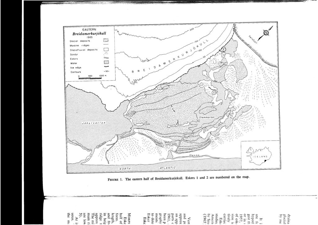
1 1 Arctic and Alpine Research, Vol. 3, No. 4, 1971, pp NVESTGATONS OF TWO ESKERS AT EASTERN BREDAMERKURJOKULL, CELAND PHLP J. HOWARTH Departnzent of Geography McMaster University Hanzilton, Ontario, Canada ABSTRACT Vertical aerial photography of Breidamerkurjokull flown in 1945 and 1965 has shown that an area containing a sandur in 1945 has developed into an esker ridge surrounded by kettle topography. Photogrammetric measurements from this photography indicate that the esker was produced by the melting out of buried ice from beneath sandur deposits on either side of the ridge. Field mapping of a second esker which was melting out of the glacer during the period of study has shown that planimetric and height changes have occurred as a result of the melting of buried ice. The plan shape of the ridge appears to be controlled by ice structures giving a distinct rectilinear pattern to the esker. A cross section dug through the ridge revealed that the gravels were underlain by ice, indicating an englacial origin for at least part of the esker. This cross section, as well as others, have shown varations in the shape of the tunnel containing the gravels. The mechanism by which the esker is lowered to the proglacial surface to form a single ridge is also discussed. NTRODUCTON During the summers of 1965 and 1966, about 1890 (Ahlmann and Thorarinsson, 1937, members of the Department of Geography at p. 196). Since then it has been generally rethe University of Glasgow carried out a series treating to reveal a surface that rises gently of geomorphological, glaciological, and photo- from the sea to altitudes of a little over 50 m i grammetric studies at Breidamerkurjiikull in close to the present ice front. southeast celand. The area was revisited for a The eastern half of the proglacial area is - short time in the summer of As part of divided from the western half by a large prothe project the author investigated the forma- glacial lake, Jokulsarlon, and its outlet river, tion of esker ridges in the eastern half of the Jokulsa (Figure 1). Close to the lake the distproglacial area. This paper presents the re- ance from the sea to the ice front is approxisults of detailed studies of two of the more in- mately 3 km. The width of the proglacial area teresting eskers. gradually increases eastwards to a maximum of Breidamerkurjokull is one of the largest 5.5 km at the eastern margin of the glacier. southern outlet glaciers of Vatnajokull. ts ice Drainage from the eastern half of the glacier front is approximately 16 km in length and is is at present dominated by the Stemma Lake bounded on either side by steep cliffs of vol- and river system. During the retreat of the canic rock rising to about 1,000 m (Figure 1). ice front, the meltwater streams became grad- The glacier reached its recent maximum extent ually concentrated into the Jiikulsa and Stemma P. J. HOWARTH / 305
2

3 drainage systems. thus leaving many areas of (Price and Howarth, 1970). This has aided the glacial and glaciofluvial deposition undisturbed the study of the eskers which might otherwise by meltwaters since the time of their formation have been destroyed by meltwaters. NVESTGATONS OF ESKERS N PRESENT-DAY GLACAL ENVRONMENTS t is generally accepted that most eskers papers, however, consider the state of the 1 are formed in subglacial tunnels, but other eskers at only one moment in time. hypotheses have been put forward which sug- Using sequential aerial photography, Petrie gest that eskers may be formed at the ice edge and Price (1966) and Price (1966) were able or in supraglacial or englacial positions (Flint, to introduce the time element into their studies 1957, pp ). Although the formation of the development of eskers at Casement of eskers has resulted in a great deal of discus- Glacier, Alaska. Changes over time were sion in geomorphological literature, compara- accurately measured using a photogrammetric 1 tively few studies of these features have been plotting machine. Similar techniques were used carried out in present-day glacial environments. by Welch and Howarth (1968) in the study of Eskers melting out of glaciers have been an esker at western Breidamerkurjokull. n both i studied in Norway by Lewis (1949), in North cases, lowering of the esker ridges due to the America by Meier (1951), and in Spitsbergen melting of buried ice indicated either an englaby Szupryczynski (1965) and by Jewtuchowicz cia1 or a supraglacial origin for the eskers. (1965). All the observations presented in these METHODS OF STUDY Vertical aerial photography of the ice front glacier until about 1960 when the scale of and proglacial area was flown in 1945 at an photography available was too small to study 1 approximate scale of 1:46,000 and in 1965 at the esker photogrammetrically. Field methods 1 an approximate scale of 1 :27,000. n addition, were, therefore, used to investigate the esker. 1 parts of the area were photographed in 1960, n 1965, twice in 1966, and once in 1968, the 1961, and Photogrammetric maps have esker was mapped at a scale of 1 :SO0 using a! been produced from the 1945 and 1965 photo- plane table and a Kern R K self-reducing graphy (Howarth, 1968), and detailed measure- alidade. n addition, cross sections were dug ments from this photography have been used through the esker to determine the nature and 1 to determine the changes that have occurred in shape of the contact zone between the ice and Esker 1 over the 20-year period. the esker gravels as they melted out of the Esker 2 did not begin to appear from the glacier. ESKER 1 MORPHOLOGY distance. Over most of its length the esker is Esker 1 is the largest esker in the eastern comparatively straight, but towards the distal half of Breidamerkurjokull and is complex in i form. t consists of a main ridge, 350 m in end there are some sharp bends in its course. The esker, in this section, descends into a length, which ranges from 5 to 15 m in width large kettle hole and rises out-again at the far and from nearly 1 m to approximately 5 m side close to a crag-and-tail. A small ridge, in height. On the northern side of the main up to 3 m high, descends into the Stemma river l ridge there are small minor ridges reaching and may form a continuation of the esker. approximately 8 m in width and 2 m in height. The general slope of the ground surface and The minor ridges connect at both ends with the of the crest of the esker is away from the main ridge of the esker and for the most part glacier. Except at the distal end, where the are lower than the main ridge (Figures 2 and ridge descends into the kettle hole, the crest of 3). the esker is very regular and flat over much of At its proximal end the esker is discontin- its length (Figure 3). uous. Toward the central section of the esker The proglacial surface surrounding the esker the main ridge divides in two, for a short is distinctly hummocky, and from south to P. J. HOWARTH 1 307

4 FGURE 2. Stereogram of Esker 1 in 1965 at an approximate scale of 1 :27,000. The esker is indicated by the arrow. Note the way in which the sandur at "a" grades into kettle topography at "b." The kettling becomes more pronounced on the opposite side of the esker from "b." FGURE 3. View looking west along the central and proximal parts of Esker 1. The glacier at its 1965 position can be seen in the background. Note the minor ridges on the right hand side of the esker, and the flat top that occurs along the major part of the main ridge. north there is a definite increase in the degree of kettle development. At the southern edge of this area a braided channel pattern on a small sandur can be clearly seen (Figure 2). Moving northward, the channel pattern becomes increasingly disturbed by the kettle development until finally the channel pattern can no longer be distinguished and a hummocky topography predominates. n this area on the south side of the esker, the difference in height between the bottom of a hollow and the top of a mound is rarely more than 1 m. Although the kettling is more strongly developed on the north side of the esker, there are few deep kettle holes. MORPHOLOGCAL CHANGES FROM 1945 TO 1965 The aerial photographs indicate that in 1945 the ice edge was situated at the present position of the proximal end of the esker (Figure 4). All that could be see of the esker was a small

5 1945 ESK ER 1 N 1945 AND ice edge Fluted moraine 2:x:p-.-..., *., Esker Kettle topography -201 Contour in metres FGURE 4. Maps showing exactly the same area in 1945 and The development of the esker ridge and the area of kettle topography surrounding it can be seen. To aid the comparison, the 1945 ice edge has been superimposed on the 1965 map.

6 Height chonge ridge that now forms the distal end. t is apparent that in 1945 the central and proximal parts of the esker did not exist. To investigate the planimetric and height changes that occurred between 1945 and 1965, photogrammetric techniques were used. Ground control points, surveyed from the celandic trignometrical system and situated on stable ground well outside the area of study, were used to scale (at 1: 15,000) and level the photography in a Wild B8 photogrammetric plotting machine. By using the grid intersections on a 0.5 cm grid of squares placed over the plot sheet, it was possible to obtain height measurements at the same planimetric position from each set of photographs. The difference between the two recorded heights - at the same planimetric point gave the change in height at that point. n areas that had not changed between 1945 and 1965, height differences of no more than +2 m were recorded. This agrees - with the theoretical spot heighting accuracy for the scales of photography used. The results of these measurements are shown in Figure 5. Along the crest of the central part of the esker ridge, the recorded differences in height are within the accuracies of the photogrammetric measurements. On either side of FGURE 5. Height changes on and around Esker 1 between 1945 and Photogrammetric s p o t heighting accuracy is correct to 2 2 m. Little or no change in height has occurred along most of the crest of the esker. Height differences over the water are minimum values. the ridge, however, large differences in height.r indicate that the surface of the sandur that existed in 1945 has been lowered by up to 8 m. ORGN From the photogrammetric height measurements it is apparent that the main part of the esker has been formed by the general lowering of the surface on either side of the ridge. For this to have occurred, it is suggested that in 1945 most of the sandur in this area must have been underlain by ice. The melting of the ice on both sides of the ridge has led to the development of the kettle topography. The increase in the hummocky nature of the kettle topography from south to north, and the greater height differences recorded on the northern side of the esker suggest that the thickness of the buried ice also increased from south to north. Photogrammetric height measurements of points on stable ground in the surrounding area have indicated that the increase in height difference from south to north is definitely not due to an uncorrected tilt in absolute orientation of the aerial photographs in the plotting machine. Although there was ice underlying the sandur, it appears that there was no ice beneath the esker ric perhaps at it is supported, length, the e5 probably for sandur in 191 The photoj that buried formation of to explain tk buried. Evid, glacial area which this m First, grav the ice along of the ice frc the ice along 1 on the surfac layer of gravc from melting further depos ensure the a1 t is difficult This is per 1 the eastern h; it was gradc during the pe vations of the presented (H more inform summers of MORPHOLOG The esker glacier and e: face between the crest of tl FGURE indicated beyond t

7 the esker ridge, except at its distal end and perhaps at its proximal end. This suggestion is supported by the fact that along most of its length, the esker has a very flat crest!ine which probably formed part of the surface of the sandur in The photogrammetric measurements indicate that buried ice has been important in the formation of the esker, but a major problem is to explain the way in which the ice became buried. Evidence from other parts of the proglacial area suggests two possible ways in which this may have occurred. First, gravels may have been carried into the ice along shear planes. Along many parts of the ice front, layers of gravels carried into the ice along these shear planes become exposed on the surface of the glacier as it melts. The layer of gravels then protects the underlying ice from melting. Resorting of the gravels and further deposition by meltwater streams could ensure the almost complete burial of the ice. t is difficult to explain the occurrence of the esker, however, unless it had already been formed within the glacier prior to the melting out of the gravels from the shear planes. f this occurred the esker could have been buried by the later deposition. Melting of the buried ice from areas surrounding the esker would then expose the ridge. A second explanation is that the gravels burying the ice were originally deposited in the glacier by englacial streams. This suggestion is supported by observations at the ice front in A horizontal layer of gravels was melting out from within the glacier in an area where there was a subglacial stream. t is possible that this stream deposited the gravels in their englacial position before it cut down through the ice to produce its subglacial course and expose the gravels. This mechanism can be applied to explain Esker 1, except that in this case the subglacial stream course would also have to become filled with gravels to eventually produce the esker ridge. ESKER 2 This is perhaps the most interesting esker in m, but by 1966 this distance had extended to the eastern half of Breidamerkurjiikull because approximately 470 m as more of the esker it was gradually melting out of the glacier melted out of the glacier. Although the csker r- during the period of study. Preliminary obser- ridge varied in height and width, it was genvations of the esker in 1965 have already been erally 15 to 20 m wide and 5 m high close to presented (Howarth, 1966), but a great deal the ice edge, but only 5 m wide and 1 m high more information was obtained during the at its distal end. summers of 1966 and Beyond the small river at the distal end of the esker it can be seen (Figure 6) that a MORPHOLOGY series of small ridges in a crows foot pattern The esker appeared on the surface of the extend into a sandur. The sandur gravels, 1 to glacier and extended across the proglacial sur- 2 m thick, overlay ice which was being eroded face between two lakes (Figure 6). n 1965, by the meltwaters of the lake during the period the crest of the esker covered a length of 420 of study. FGURE 6. Stereogram of Esker 2 in 1965 at an approximate scale of 1:27,000. The esker, indicated by the arrow, can be seen melting out of the glacier. Note the "crows foot" pattern beyond the small river at the distal end of the esker. P. J. HOWARTH / 311
 at various times during the period of study.")
8 MORPHOLOGCAL ~ANGES FROM 1965 TO 1968 n order to determine the changes that were taking place, the esker was mapped by p!ane table and self-reducing alidade (at a scale of 1 :500) at various times during the period of study. Planimetric positions were calculated and plotted to the nearest meter, while heights were determined to the nearest 10 cm. A comparison of the maps in the areas that did not change indicates that heights are correct to + 20 cm, and that errors in planimetric position are probably no more that 2 2 m, the greatest errors occurring when sightings were taken over long distances. Pa?limetric Changes A study of the maps indicates that during 1965 and 1966 the esker gradually melted out of the glacier revealing sections running either parallel with or at right angles to the ice edge. Major changes, however, occurred between 1966 and 1968 when a meltwater stream started to flow from beneath the ice edge in this area. The stream removed the proximal end of the esker which had melted out of the glacier in 1966 and left in its place a small sandur between the esker and the 1968 ice edge. A meltwater channel was also cut through the esker which drained a large pool that formed against the esker at the end of August Height Changes Comparisons of the four maps indicate that there have been comparatively large changes in height along the crest of the esker. From the points surveyed along the ridge crest each time the esker was mapped, it has been possible to plot profiles to determine the height changes that have taken place during the period of study (Figure 7). t can be seen that during the year from August 8, 1965, to August 8, 1966, maximum changes in height of 4 to 5 m occurred along part of the esker. Further height changes occurred between 1966 and 1968, resulting in a maximum lowering of the crest of the esker by 5.5 m over the 3-year period. During this time there was no apparent change in altitude at the base of the esker. n 1968, it appeared that the remnants of the esker had almost reached a stable situation since there was little evidence of buried ice or rapid lowering of the crest of the esker ridge. As care was taken not to disturb the crest of the esker during mapping, all the changes may be considered a result of natural causes. n part, the changes were due to collapse of gravels from the crest of the ridge, but as will be shown later, the melting of buried ice was also important. CROSS SECTONS THROUGH THE ESKER From the changes in height along the crest of the esker it was impossible to tell whether the sands and gravels of the esker extended to the subglacial floor or whether they were underlain by ice. Thus, in order to determine whether the esker was formed subglacially or englacially, cross sections were dug to the base of the esker. This was an extremely difficult task because of the hardness of the glacier ice and the slumping of the unstable material forming the esker. n 1965 the base of the esker was not reached, but in the upper parts of three cross sections it was possible to study the nature and position of the boundary between the sands and gravels of the esker and the surrounding glacier ice (Howarth, 1966, pp. 7-8). This boundary will be referred to as the ice/esker contact. The cross sections indicated that where the esker ridge ran parallel to the ice edge, the ice/esker contacts on both sides of the ridge dipped up-glacier at a steep angle. Where the ridge was at right angles to the ice edge, the ice/esker contacts dipped away from the crest of the ridge. By 1966, a surface stream had cut completely through the esker to reveal a fourth cross section. The cross section showed without doubt that this part of the esker had an englacial origin (Figures 8 and 9). Although it was impossible to measure the thickness of the ice beneath the esker accurately, it was estimated that the gravels overlay approximately 3 m of ice. On the up-glacier side of the esker (G), the ice/esker contact dipped upglacier at an angle of 80" to the horizontal. On the down-glacier side of the esker (H, the ice had melted away. This side of the esker faces the sun, and it is likely that the heating of the sands and gravels caused the buried ice to melt away more rapidly. However, it has been shown in another cross section that the ice/esker contact on this side of the ridge dipped up-glacier (Howarth, 1966) and it may be suggested that this was originally the case in Cross Section 4 as the two cross sections were only 3 m apart. One of the most interesting aspects of Cross Section 4 was a band of sands and gravels dipping up-glacier at an angle ranging from 10 to
9
.")
10 FGURE 8. Cross section 4 in Esker 2. The ice which formed the side of the tunnel on the left or south east side of the esker has melted. Note the ice underlying the core of the esker indicating its englacial origin. The glacier is to the right of the photograph. 35" (Figures 8 and 9). The band connected with the base of the esker and gave every appearance of being a shear plane. Looking into the ice, the strike of the band could be seen running parallel with the crest of the esker ridge. A fabric analysis carried out in the band showed a preferred orientation at right angles to the strike of the shear plane, suggesting that the gravels had been carried into the shear plane from the base of the glacier. n the lower 20 cm of the esker it was found that the gravels were surrounded by ice. This was much clearer and less granular than the normal glacier ice, and it is suggested that this ice within the esker was refrozen meltwater. n 1966, Cross Section 5 was dug in a part of the esker running at right angles to the ice edge (Figure 10). n this case, the form of the ice/esker contact was entirely different when compared with Cross Section 4. n Cross Section 5 the esker occupied a semicircular hollow in the glacier. At the bottom of the hollow the ice dipped steeply downwards to form a narrow funnel extending to the subglacia1 surface. Again the gravels in the bottom of the esker were surrounded by refrozen meltwater. n the frontal zone of Breidamerkurjokull, crevasses are developed at right angles to the ice edge as the glacier spreads out in the proglacial area. t is possible that the funnelshaped hollow at the base of Cross Section 5 represents the bottoms of a crevasse or line of weakness in which the tunnel has been formed. STRUCTURAL CONTROL OF THE ESKER t has already been pointed out that parts of the esker run parallel with the ice edge, while other parts are at right angles to the ice edge. From the preliminary observations of the esker it was concluded that this regular layout of the different sections of the esker as they melt out of the glacier "suggests that the structure of the ice exerts a control on the plan of the esker" (Howarth, 1966, p. 9). Recent work by Stenborg (1968) lends support to this suggestion in that he has shown that meltwater streams both on and below the surface of the glacier are primarily controlled by ice structures, At Breidamerkurjokull, it appears probable that shear planes and crevasses are the two main factors providing structural control, parallel with and at right angles to the ice edge respectively. The importance of structural control is further emphasized by the fact that within the glacier the shape of the tunnel in which the glaciofluvial material has been deposited appears to depend on whether the esker is running parallel with or at right angles to the ice edge. Three cross sections dug where the esker was parallel with the ice edge showed that the shape of the tunnel was in the form of a parallelogram, with both sides of the tunnel dipping up-glacier at a steep angle. n the other two cross sections, however, where the esker was at right angles to the ice edge, the tunnel was rounded in cross section. What effects ice movement may have are not kno~ behj righ mob edgc mer: the doer devc

11 ESKER 2 - CROSS SECTON _/----- ice up to 3 metres thick Cenf8merer FGURE 9. Cross section 4 in Esker 2. ESKER2 - CROSS SECTON centimetres known. n 1966 a line of stakes was placed behind the esker extending up-glacier and at right angles to the ice edge. Although no ice movement was recorded 40 m from the ice edge, over a period of 51 days total ice movement of 40 cm was recorded at 175 m from the ice edge. t is thus apparent that a glacier does not have to be stagnant for the effective development of eskers to take place. THE DEVELOPMENT OF THE ESKER RDGE n areas close to the ice edge the sides of FGURE 10. Cross section 5 in Esker 2. the esker consist of a layer of gravels, only a few centirnetres thick, overlaying ice. When the esker melts out of the glacier, the upper parts of the esker are comparatively stable and stand out as a ridge. The surrounding glacier ice continues to melt. As the esker ridge dries out and the finer particles in the gravels lose their cohesion, the ridge becomes unstable. Wind erosion and rain add to the instability and sands and gravels from the ridge start to slump down onto the clean ice surrounding the esker. The sands and gravels then greatly reduce the P. J. HOWARTH/ 315

12 rate of melting of the underlying ice. Beyond the limit of the slumped material the glacier ice continues to melt away, but all the time material is continuing to fall from the esker and move down the slope of the already protected ice. n this way, the extent of the slumped material gradually increases to cover more and more of the clean glacier ice and to inhibit its rate of melting. By the time that all surrounding glacier ice has melted away from the area, an esker with ice underlying its slopes of slumped gravel has been formed and a condition of comparative stability is established. t must be emphasized, however, that the amount of material falling from the crest of the esker is comparatively small compared with the total volume of sand and gravel within the esker. The slumped material on the slopes of the esker is only a few centimeters thick and has an angle of rest on the ice of approximately 30 to 35'. As the ice core continues to melt, Esker 1 may be classified as a proglacial esker in that its development took place in the proglacial environment after the retreat of the ice edge. Other suggested mechanisms for the development of proglacial eskers, however, involve direct deposition of glaciofluvial material by streams flowing out from the ice edge (Flint, 1957). t could be argued that Esker 1 is not a true esker because its form is dependent upon the inelting out of buried ice from areas surrounding the ridge. n some areas of kame and kettle topography or in extensively pitted sandur it is possible to have series of sinuous ridges produced as remnants by the melting out of ice to form kettle holes. This type of topography has been described by Price (1969) at western Breidamerkurjokull, and on Baffin sland, King and Buckley (1969) have described esker-like ridges near Eqe Bay which are thought to have developed from accumulations of sediment between blocks of dead ice. At eastern Breidamerkuriokull. however, the main ridge stands well above the surrounding kettle topography to form a distinct feature. n addition, it does not occur as the side of a kettle hole, as would be the case if it had developed as an integral part of a pitted sandur or general area of dead ice topography. The area was originally developed as a sandur so that the whole ridge almost DSCUSSON the main body of the esker is gradually lowered on to the ground surface. Thus a single esker ridge is formed which still maintains a stratified internal structure, because the rate of melting of the ice core is more rapid than the slumping of the sands and gravels from the crest of the esker. t is suggested that a similar sequence of events will occur whether the esker is formed subglacially, englacially, or supraglacially. Only two conditions are necessary. First, the glacier surface at the ice edge must have a comparatively low gradient so that the esker is able to melt out on to the surface of the glacier. Second, as the esker melts out of the glacier its sides must be in contact with the ice so that material falling from the crest of the esker will bury the surrounding glacier ice. Thus the presence of ice at the sides of an esker does not necessarily indicate an ice core beneath the whole of the esker. certainly consists of stratified deposits, although it was not possible to study the internal composition in great detail. Thus from its form and general stratified nature it would seem valid to classify the ridge as an esker. Doubts were expressed by Crosby (1902) and more recently by Jewtuchowicz (1965) that englacial or supraglacial eskers could be lowered to the proglacial surface to form single ridges. Observations by Price (1966) at the Casement Glacier as well as observations of Esker 2 reported in this paper have shown that this is possible. Price (1966, p. 124) shows in diagrammatic form how this can happen and he suggests that if rapid lowering takes place a single ridge will form, but if the ice core only melts slowly it is likely that two ridges will be developed by the slumping of debris to either side from the crest of the esker. t is interesting to note that at eastern Breidamerkurjokull, where the ice core is very much thinner than that observed at the Casement Glacier, the reverse occurs. Under normal conditions of slow melting the single esker ridge is lowered slowly to the proglacial surface, while rapid collapse of the ice core (usually due to streams penetrating beneath the ice core and causing an increase in ablation) leads to the development of a number of small ridges. The i eartern different velop. 1 produced out of b from be surface. The o Were car kurjokull Departmc Glasgow, thank Dr fessor R COuragem field was A. Dunc Rose, an( Finnnc Ahlmann, 1937 Crosby, W Flint, R. F 1957

13 SUMMARY The investigations of two esker ridges at eastern Breidamerkurjokull have shown two different ways in which esker ridges may develop. The ridge forming Esker 1 has been produced in the proglacial area by the melting out of buried ice, on either side of the ridge, from beneath what was originally a sandur surface. nitial deposition of the gravels form- ing the esker appears to have occurred beneath the ice in a subglacial stream course. Esker 2 was in part formed in an englacial tunnel. the plan shape of the tunnel being controlled by structures within the ice. Upon melting out of the glacier, the major part of the esker has been lowered to the proglacial surface as a single ridge. ACKNOWLEDGMENTS The observations presented in this paper Project was provided by the Natural Environwere carried out as a part of the Breidamer- ment Research Council, the Court of the Unikurjhkull Project organized by members of the versity of Glasgow, the Carnegie Trust for the Department of Geography at the University of Universities of Scotland, the Royal Geographi- Glasgow, Scotland. The author would like to cal Society, and the Gino Watkins Memorial thank Dr. R. J. Price, Mr. G. Petrie, and Pro- Fund. From 1965 to 1967 the author was in fessor R. Miller for their support and en- receipt of an N.E.R.C. Studentship.! couragement in this work. Assistance in the n celand, assistance was received from 1 field was willingly provided by K. Doughty, Landmaelingar slands (celandic Survey De- A. Duncan, N. Graham, R. MacDonald, J. partment), Vegagerd Rikisins (Public Roads Rose, and D. Woolnough. Administration), and Dr. S. Thorarinsson of Financial support for the Breidamerkurjokull the celandic Museum of Natural History. REFERENCES Ahlmann, H. W. and Thorarinsson, S. King, C. A. M. and Buckley, J. T : Vatnajiikull. Scientific results of the 1969 : Geomorphological investigations in Swedish-celandic investigations west-central Baffin sland, N.W.T., Chapter 111. Previous investi- Canada. Arctic and Alpine Res., l(2) : gations of Vatnajokull, marginal oscil lations of its outlet-glaciers, and general Lewis, W. V. description of its morphology. Geogr : An esker in process of formation: Ann., 19: Bbverbreen, Jotunheimen, J. Crosby, W. 0. Glacial., 1 : : Origin of eskers. Amer. Geol., 30(1) : Meier, M. F : Recent eskers in the Wind River Mountains of Wyoming. Proc. owa 1957 : Glacial and Plezstocene Geology. John Acad. Sci., 58: Wiley, New York. 553 pp. Petrie, G. and Price R. J. Howarth, P. J : Photogrammetric measurements of the 1966 : An esker, Breidamerkurjokull, celand. ice wastage and morphological changes Brit. Geomorphol. Res. Group., near the Casement Glacier, Alaska. Occas. Pap., 3: 6-9. Can. J. Earth Sci., 3 (6): : Geomorphological and glaciological Price, R. J. studies, eastern Breidamerkurjbkull, 1966 : Eskers near the Casement Glacier, celand. Unpublished Ph.D. Thesis, Alaska. Geogr. Ann., 48A(3): 111- University of Glasgow. 384 pp Jewtuchowicz, S. Price, R. J. and Howarth, P. J : Description of eskers and kames in 1970 : The evolution of the drainage system Gashamnoyra and on Bungebreen, ( ) in front of Breidamersouth of Hornsund, Vestspitsbergen. kurjokull, celand. Jokull, 20: 27- J. Glacial., 5: P. J. HOWARTH / 317
14 Stenborg, T. Welch, R. and Howarth, P. J : Glacier drainage connected with ice 1968 : Photogrammetric measurements of glastructures. Geogr. Ann., 50A(1) : 25- cial landforms. Photogramm. Rec., 53. 6: Szupryczynski, J : Eskers and kames in the Spitsbergen area. Geogr. Polonica, 6: Ms submitted March 1971 Arctic and. This paper geomorphic augmented s designed. t which call bc to give three "plot model" between geo responses of scale (abou system, defin The study volved in thi normally con ments which independent are generally processes, th mechanical s sediment yiel the classical work has be in this area. comprise de: within whicf are frequent relative relic density but a biotic factors
glacial drift: all deposits associated with glaciation; covers 8% of Earth s surface above sealevel, and 25% of North America
 Glacial depositional features glacial drift: all deposits associated with glaciation; covers 8% of Earth s surface above sealevel, and 25% of North America i) nonstratified drift till: transported & deposited
PHYSICAL GEOGRAPHY GEOGRAPHY EARTH SYSTEMS COASTAL SYSTEMS FLUVIAL SYSTEMS
 PHYSICAL GEOGRAPHY EARTH SYSTEMS FLUVIAL SYSTEMS COASTAL SYSTEMS PHYSICAL GEOGRAPHY CORRIES / CIRQUES A Corrie or Cirque is the armchair shaped hollow that was the birthplace of a glacier. It has steep,
READING QUESTIONS: Chapter 7, Glaciers GEOL 131 Fall pts. a. Alpine Ice from larger ice masses flowing through a valley to the ocean
 READING QUESTIONS: Chapter 7, Glaciers GEOL 131 Fall 2018 63 pts NAME DUE: Tuesday, October 23 Glaciers: A Part of Two Basic Cycles (p. 192-195) 1. Match each type of glacier to its description: (2 pts)
READING QUESTIONS: Glaciers GEOL /WI 60 pts. a. Alpine Ice from larger ice masses flowing through a valley to the ocean
 READING QUESTIONS: Glaciers GEOL 131 18/WI 60 pts NAME DUE: Tuesday, March 13 Glaciers: A Part of Two Basic Cycles (p. 192-195) 1. Match each type of glacier to its description: (2 pts) a. Alpine Ice from
Gifts of the Glaciers
 Gifts of the Glaciers Gifts of the Glaciers Moving ice of glacier was responsible for water, landforms, and soil characteristics and patterns of today Sculpturing of bedrock materials Glacial Landforms
glacier Little Ice Age continental glacier valley glacier ice cap glaciation firn glacial ice plastic flow basal slip Chapter 14
 Little Ice Age glacier valley glacier continental glacier ice cap glaciation firn glacial ice plastic flow basal slip glacial budget zone of accumulation zone of wastage glacial surge abrasion glacial
Recrystallization of snow to form LARGE. called FIRN: like packed snowballs. the weight of overlying firn and snow.
 Chapter 11 Glaciers BFRB P. 103-104, 104, 108, 117-120120 Process of Glacier Formation Snow does NOT melt in summer Recrystallization of snow to form LARGE crystals of ice (rough and granular) called
Glacial Geomorphology Exercise
 James Madison University Field Course in western Ireland Glacial Geomorphology Exercise 3-day road log (abbreviated) Striations Large kame terrace Cirque with moraines Kame delta Striations Eskers Raised
MIDDLE SCHOOL CURRICULUM TR AILING ICE AGE M YST ERI E S ICE AGE TREKKING
 MIDDLE SCHOOL CURRICULUM TR AILING ICE AGE M YST ERI E S ICE AGE TREKKING CONTENTS I. Enduring Knowledge... 3 II. Teacher Background... 3 III. Before Viewing this Video... 5 IV. Viewing Guide... 5 V. Discussion
1 Glacial Erosion and
 www.ck12.org Chapter 1. Glacial Erosion and Deposition CHAPTER 1 Glacial Erosion and Deposition Lesson Objectives Discuss the different erosional features formed by alpine glaciers. Describe the processes
MIDDLE SCHOOL CURRICULUM TR AILING ICE AGE M YST ERI E S SEARCHING GLACIAL FEATURES
 MIDDLE SCHOOL CURRICULUM TR AILING ICE AGE M YST ERI E S SEARCHING GLACIAL FEATURES CONTENTS I. Enduring Knowledge... 3 II. Teacher Background... 3 III. Before Viewing the Video... 5 IV. Viewing Guide...
2. (1pt) From an aircraft, how can you tell the difference between a snowfield and a snow-covered glacier?
 From an aircraft, how can you tell the difference between a snowfield and a snow-covered glacier?") 1 GLACIERS 1. (2pts) Define a glacier: 2. (1pt) From an aircraft, how can you tell the difference between a snowfield and a snow-covered glacier? 3. (2pts) What is the relative size of Antarctica, Greenland,
1 GLACIERS 1. (2pts) Define a glacier: 2. (1pt) From an aircraft, how can you tell the difference between a snowfield and a snow-covered glacier? 3. (2pts) What is the relative size of Antarctica, Greenland,
12: MELTWATER LANDFORM IDENTIFICATION
 Glacial Geology 12. Meltwater Landform Identification 12: MELTWATER LANDFORM IDENTIFICATION 60 Points Objective: learn how to identify meltwater landforms and their characteristics in photos and on topographic
The Potentially Dangerous Glacial Lakes
 Chapter 11 The Potentially Dangerous Glacial Lakes On the basis of actively retreating glaciers and other criteria, the potentially dangerous glacial lakes were identified using the spatial and attribute
Glaciers Earth 9th Edition Chapter 18 Mass wasting: summary in haiku form Glaciers Glaciers Glaciers Glaciers Formation of glacial ice
 1 2 3 4 5 6 7 8 9 10 11 12 13 14 15 Earth 9 th Edition Chapter 18 Mass wasting: summary in haiku form Ten thousand years thence big glaciers began to melt - called "global warming." are parts of two basic
The Physical Geography of Long Island
 The Physical Geography of Long Island A Bit About Long Island Length 118 miles Brooklyn to Montauk Geo202 Spring 2012 Width 23 miles at it s widest Area 1,400 square miles Formation of Long Island River
Glaciers and Glaciation Earth - Chapter 18 Stan Hatfield Southwestern Illinois College
 Glaciers and Glaciation Earth - Chapter 18 Stan Hatfield Southwestern Illinois College Glaciers Glaciers are parts of two basic cycles: 1. Hydrologic cycle 2. Rock cycle A glacier is a thick mass of ice
Geomorphology. Glacial Flow and Reconstruction
 Geomorphology Glacial Flow and Reconstruction We will use simple mathematical models to understand ice dynamics, recreate a profile of the Laurentide ice sheet, and determine the climate change of the
Glaciers. Clicker Question. Glaciers and Glaciation. How familiar are you with glaciers? West Greenland. Types of Glaciers.
 Chapter 21 Glaciers A glacier is a large, permanent (nonseasonal) mass of ice that is formed on land and moves under the force of gravity. Glaciers may form anywhere that snow accumulation exceeds seasonal
A TOPOGRAPHIC FEATURE OF THE HANGING VALLEYS OF THE YOSEMITE.
 A TOPOGRAPHIC FEATURE OF THE HANGING VALLEYS OF THE YOSEMITE. THE larger hanging valleys around the Yosemite valley have topographic features in common that are interesting in themselves, and they likewise
GLACIER STUDIES OF THE McCALL GLACIER, ALASKA
 GLACIER STUDIES OF THE McCALL GLACIER, ALASKA T John E. Sater* HE McCall Glacier is a long thin body of ice shaped roughly like a crescent. Its overall length is approximately 8 km. and its average width
Glacial Origins and Features of Long Island
 Glacial Origins and Features of Long Island Interior Coastal Plain Continental Shelf Long Island s Geology 0 Ma Phanerozoic 540 Ma Proterozoic 2500 Ma Archean 3800 Ma Hadean 4600 Ma C M P Geologic Time
47I THE LAS ANIMAS GLACIER.
 THE LAS ANIMAS GLACIER. ONE of the largest of the extinct glaciers of the Rocky Mountains was that which occupied the valley of the Las Animas river. This stream originates in the San Juan mountains in
Chapter 16 Glaciers and Glaciations
 Chapter 16 Glaciers and Glaciations Name: Page 419-454 (2nd Ed.) ; Page 406-439 (1st Ed.) Part A: Anticipation Guide: Please read through these statements before reading and mark them as true or false.
1.4 Understand how moving ice acts as an agent of erosion and deposition. (Chap. 2)
") 1.4 Understand how moving ice acts as an agent of erosion and deposition. (Chap. 2) There are two types of glaciation. Alpine Glaciation Continental Glaciation Distinguish between the terms alpine glaciation
1.4 Understand how moving ice acts as an agent of erosion and deposition. (Chap. 2) There are two types of glaciation. Alpine Glaciation Continental Glaciation Distinguish between the terms alpine glaciation
NORTH CASCADE SLACIER CLIMATE PROJECT Director: Dr. Mauri S. Pelto Department of Environmental Science Nichols College, Dudley MA 01571
 NORTH CASCADE SLACIER CLIMATE PROJECT Director: Dr. Mauri S. Pelto Department of Environmental Science Nichols College, Dudley MA 01571 INTRODUCTION The North Cascade Glacier-Climate Project was founded
Glaciers. Glacier Dynamics. Glacier Dynamics. Glaciers and Glaciation. Types of Glaciers. Chapter 15
 Chapter 15 Glaciers and Glaciation Glaciers A glacier is a large, permanent (nonseasonal) mass of ice that is formed on land and moves under the force of gravity. Glaciers may form anywhere that snow accumulation
ENVI2030L - ALPINE AND CONTINENTAL GLACIATION
 NAME ENVI2030L - ALPINE AND CONTINENTAL GLACIATION I. Introduction Glaciers are slowly moving ice sheets. They are very effective erosional agents and can drastically modify the landscapes over which they
A trip to Steindalen. - geology and landscape on the way to the glacier. Geoffrey D. Corner
 A TRIP TO STEINDALEN Excursion guide Please take this with you on your trip, but don t leave it behind as litter. A trip to Steindalen - geology and landscape on the way to the glacier A part of Geologiskolen,
THE INFLUENCE OF DEBRIS ON THE FLOW OF GLACIERS.
 THE INFLUENCE OF DEBRIS ON THE FLOW OF GLACIERS. THE behavior of ice under various conditions is frequently illustrated by experiments with pitch or other similar viscous fluids or plastic solids. If sand
Dynamic Planet: Glaciers
 Team Name+Number Teammate 1 name Teammate 2 name Dynamic Planet: Glaciers (by Shad160) The following test is 80 questions long, split up into four different sections. The first 20 questions are worth 40
Typical avalanche problems
 Typical avalanche problems The European Avalanche Warning Services (EAWS) describes five typical avalanche problems or situations as they occur in avalanche terrain. The Utah Avalanche Center (UAC) has
HYDROLOGY OF GLACIAL LAKES, FORT SISSETON AREA
 PROC. S.D. ACAD. SCI., VOL. 77 (1998) 59 HYDROLOGY OF GLACIAL LAKES, FORT SISSETON AREA Perry H. Rahn Department of Geology & Geological Engineering South Dakota School of Mines and Technology Rapid City,
Architectural Analysis in Western Palenque
 Architectural Analysis in Western Palenque James Eckhardt and Heather Hurst During the 1999 season of the Palenque Mapping Project the team mapped the western portion of the site of Palenque. This paper
Glaciers and Glaciation
 Chapter 18 Lecture Earth: An Introduction to Physical Geology Eleventh Edition Glaciers and Glaciation Tarbuck and Lutgens Glaciers: A Part of Two Basic Cycles A glacier is a thick mass of ice that forms,
Glaciers. Glacier Dynamics. Glaciers and Glaciation. East Greenland. Types of Glaciers. Chapter 16
 Chapter 16 Glaciers A glacier is a large, permanent (nonseasonal) mass of ice that is formed on land and moves under the force of gravity. Glaciers may form anywhere that snow accumulation exceeds seasonal
Property access tracks
 Property access tracks Planning, location, construction and maintenance The need for farm roads and tracks The efficient running of a property depends on, among other things, ready access to various locations
Tidewater Glaciers: McCarthy 2018 Notes
 Tidewater Glaciers: McCarthy 2018 Notes Martin Truffer, University of Alaska Fairbanks June 1, 2018 What makes water terminating glaciers special? In a normal glacier surface mass balance is always close
GEOMORPHOLOGY EXAM #3
 Formation of Glaciers GEOMORPHOLOGY EXAM #3 - Transformation of snow into glacial ice - Density; SNOW = 0.07 0.18 g/cc FIRN(Neve) = 0.4 0.8 g/cc (Pellets) GLACIAL ICE = 0.8 0.9 g/cc - Firn / Ice Boundary
Great Science Adventures
 Great Science Adventures Lesson 18 How do glaciers affect the land? Lithosphere Concepts: There are two kinds of glaciers: valley glaciers which form in high mountain valleys, and continental glaciers
Exemplar for Internal Achievement Standard Geography Level 1. Conduct geographic research, with direction
 Exemplar for internal assessment resource Geography for Achievement Standard 91011 Exemplar for Internal Achievement Standard Geography Level 1 This exemplar supports assessment against: Achievement Standard
Darwin s gigantic blunder
 Trail Darwin s gigantic blunder Explore how ice shaped the landscape and why Charles Darwin made a nice mess of Glen Roy Time: 1hr 10 mins Distance: 2 miles Landscape: rural At Glen Roy a curious feature
Geography 120, Instructor: Chaddock In Class 13: Glaciers and Icecaps Name: Fill in the correct terms for these descriptions: Ablation zone: n zne:
 Geography 120, Instructor: Chaddock In Class 13: Glaciers and Icecaps Name: Fill in the correct terms for these descriptions: Ablation zone: The area of a glacier where mass is lost through melting or
Glaciers. Chapter 17
 Glaciers Chapter 17 Vocabulary 1. Glacier 2. Snowfield 3. Firn 4. Alpine glacier 5. Continental glacier 6. Basal slip 7. Internal plastic flow 8. Crevasses 9. Glacial grooves 10. Ice shelves 11. Icebergs
Please make sure that all teachers and chaperones attending the field study are aware of the following information:
 Dear Teacher, Thank you for signing up for The Ice Age at the Lost Valley Visitor Center in Glacial Park. The visitor center is located in the middle of Glacial Park. Follow the signs from the Harts Road
Glaciology. Water. Glacier. Moraine. Types of glacier-dammed lakes. Mechanics of jökulhlaup
 A Jökulhlaup Jökulhlaup. Catastrophic events where large amounts of water are suddenly discharged. Jökulhlaup s are a sudden and rapid draining of a glacier dammed lake or of water impounded within a glacier.
Lidar Imagery Reveals Maine's Land Surface in Unprecedented Detail
 Maine Geologic Facts and Localities December, 2011 Lidar Imagery Reveals Maine's Land Surface in Unprecedented Detail Text by Woodrow Thompson, Department of Agriculture, Conservation & Forestry 1 Introduction
Chapter 14. Glaciers and Glaciation
 Chapter 14 Glaciers and Glaciation Introduction Pleistocene Glaciations: A series of "ice ages" and warmer intervals that occurred 2.6 million to 10,000 years ago. The Little Ice Age was a time of colder
Lesson. Glaciers Carve the Land A QUICK LOOK. Overview. Big Idea. Process Skills Key Notes
 EARTH S CHANGING SURFACE CLUSTER 2 HOW THE EARTH S SURFACE CHANGES Lesson 62 Glaciers Carve the Land A QUICK LOOK Big Idea Moving water, ice, and wind break down rock, transport materials, and build up
Below is an example of a well laid-out template of a route card used by the Sionnach Team which is a good format to begin with.
 Route Card A route card is used as a navigational aid to hill walkers by setting out a step by step plan for an intended hike. It is good practice to make out a route card before every hike you or your
Teacher s Guide For. Glaciers
 Teacher s Guide For Glaciers For grade 7 - College Program produced by Centre Communications, Inc. for Ambrose Video Publishing, Inc. Executive Producer William V. Ambrose Teacher's Guide by Mark Reeder
Did It. naturalists. Young. Moving and melting ice shaped many of Minnesota s land features. 30 Minnesota Conservation Volunteer
 Young naturalists by Mary Hoff Photography by Gary Alan Nelson T he Glacier Did It Moving and melting ice shaped many of Minnesota s land features. Shut your eyes. Imagine that it s a sunny summer day
1.1.1 Landscape character This is the upper part of a bowl-shaped landform, extending east from the Rothiemurchus character area, contained by the
 1.1 Glen More 1.1.1 Landscape character This is the upper part of a bowl-shaped landform, extending east from the Rothiemurchus character area, contained by the arc of the high granite pluton of the Cairngorms
Q: What is a period of time whereby the average global temperature has decreased? Q: What is a glacier?
 Q: What is a glacier? A: A large sheet of ice which lasts all year round. Q: What is a period of time whereby the average global temperature has decreased? A: A glacial. Q: What is an interglacial? Q:
Glaciers. Valley or Alpine glaciers. Ice sheets. Piedmont - foot of the mountain glaciers. Form in mountainous areas Move downslope in valleys
 Glaciers & Ice Ages Glaciers Valley or Alpine glaciers Form in mountainous areas Move downslope in valleys Ice sheets Move outward from center Continental glaciers - large scale, ice age type. Presently
Geoscape Toronto The Oak Ridges Moraine Activity 2 - Page 1 of 10 Information Bulletin
 About 13,000 years ago as the Laurentide Ice Sheet melted, glacial meltwater accumulated between the ice sheet and the Niagara Escarpment. This formed a lake basin into which gravel and sand were deposited.
Barbara Borowiecki University of Wisconsin - Milwaukee
 POTENTIAL SIGNIFICANCE OF DRu}~IN FIELD MODIFICATION Barbara Borowiecki University of Wisconsin - Milwaukee Spatial characteristics of numerous drumlin fields, including the one in Wisconsin, have been
Red Tarn, Lake District They are all features of glacial erosion
 Ribbon Lake Lake Windermere, Lake District Arete Striding Edge, Lake District 1 2 3 Pyramidal Peak Corrie & Tarn 4 Matterhorn, Switzerland Red Tarn, Lake District They are all features of glacial erosion
Using LiDAR to study alpine watersheds. Chris Hopkinson, Mike Demuth, Laura Chasmer, Scott Munro, Masaki Hayashi, Karen Miller, Derek Peddle
 Using LiDAR to study alpine watersheds Chris Hopkinson, Mike Demuth, Laura Chasmer, Scott Munro, Masaki Hayashi, Karen Miller, Derek Peddle Light Detection And Ranging r t LASER pulse emitted and reflection
Remote Sensing into the Study of Ancient Beiting City in North-Western China
 Dingwall, L., S. Exon, V. Gaffney, S. Laflin and M. van Leusen (eds.) 1999. Archaeology in the Age of the Internet. CAA97. Computer Applications and Quantitative Methods in Archaeology. Proceedings of
GLACIATION. The Last Ice Age (see Chapter 12) and. Pleistocene Ice Cap. Glacial Dynamics 10/2/2012. Laurentide Ice Sheet over NYS
 and. Pleistocene Ice Cap. Glacial Dynamics 10/2/2012. Laurentide Ice Sheet over NYS") GLACIATION and New York State Prof. Anthony Grande The Last Ice Age (see Chapter 1) The Pleistocene Epoch began 1.6 mya. During this time, climates grew colder. There were numerous ice ages starting 100,000000
GLACIATION and New York State Prof. Anthony Grande The Last Ice Age (see Chapter 1) The Pleistocene Epoch began 1.6 mya. During this time, climates grew colder. There were numerous ice ages starting 100,000000
Shaping of North America. Physical Geography II of the United States and Canada. The Last Ice Age. The Ice Age. Pleistocene Polar Ice Cap 2/14/2013
 Physical Geography II of the United States and Canada Prof. Anthony Grande AFG 2012 Shaping of North America The chief shaper of the landscape of North America is and has been running water. Glaciation
Glaciers. Reading Practice
 Reading Practice A Glaciers Besides the earth s oceans, glacier ice is the largest source of water on earth. A glacier is a massive stream or sheet of ice that moves underneath itself under the influence
BLASTING GLACIAL ICE AND SNOW ABSTRACT
 BLASTING GLACIAL ICE AND SNOW HERB BLEUER ABSTRACT This presentation, with the aid of slides, is about methods of blasting large quantities of glacial ice and snow. The project illustrated here involved
TEACHER PAGE Trial Version
 TEACHER PAGE Trial Version * After completion of the lesson, please take a moment to fill out the feedback form on our web site (https://www.cresis.ku.edu/education/k-12/online-data-portal)* Lesson Title:
Glaciers Earth Chapter 18 Chapter 18 Glaciers & Glaciation Glaciers: A Part of Two Basic Cycles Glaciers: A Part of Two Basic Cycles Valley Glacier
 1 2 3 4 5 6 7 8 9 10 11 12 Glaciers Earth Chapter 18 Chapter 18 Glaciers & Glaciation A glacier is a thick mass of ice that forms, over hundreds and thousands of years, by the accumulation, compaction,
LAB P - GLACIAL PROCESSES AND LANDSCAPES
 Introduction LAB P - GLACIAL PROCESSES AND LANDSCAPES Ice has been a significant force in modifying the surface of the earth at numerous times throughout Earth s history. Though more important during the
HEATHROW COMMUNITY NOISE FORUM
 HEATHROW COMMUNITY NOISE FORUM 3Villages flight path analysis report January 216 1 Contents 1. Executive summary 2. Introduction 3. Evolution of traffic from 25 to 215 4. Easterly departures 5. Westerly
Introduction to Safety on Glaciers in Svalbard
 Introduction to Safety on Glaciers in Svalbard Content Basic info on Svalbard glaciers Risk aspects when travelling on glaciers Safe travel on glaciers UNIS safety & rescue equipment Companion rescue in
Identification and Classification of Kettle Chains Using 2 meter Digital Elevation Model of Long Island! -Sean Tvelia-!
 Identification and Classification of Kettle Chains Using 2 meter Digital Elevation Model of Long Island -Sean Tvelia- Recently released 2.0 meter Digital Elevation Models (DEMs) of the central and eastern
Specification for Grip blocking using Peat Dams
 Technical Guidance Note 1 Specification for Grip blocking using Peat Dams 1. Introduction Moorland drains (grips) have been dug across much of the Yorkshire upland peatlands. Many of these grips have become
5 MAP SPECIFICATION FOR SKI-ORIENTEERING
 5 MAP SPECIFICATION FOR SKI-ORIENTEERING 5.1 General Maps for ski orienteering are based on the specifications for foot-orienteering maps. However in order to meet the specific requirements put on the
I. Types of Glaciers 11/22/2011. I. Types of Glaciers. Glaciers and Glaciation. Chapter 11 Temp. B. Types of glaciers
 Why should I care about glaciers? Look closely at this graph to understand why we should care? and Glaciation Chapter 11 Temp I. Types of A. Glacier a thick mass of ice that originates on land from the
GC 225 Lecture Exam #2
 GC 225 Lecture Exam #2 Direction- path along which something is moving. 3 Types; - COMPASS DIRECTIONAL NAME (32 in total) - BEARING (four 0 o - 90 o ) - AZIMUTHS (0 o - 360 o ) Compass (32 named points)
P1.4 THE INFLUENCE OF METEOROLOGICAL AND GEOLOGICAL PROCESSES ON THE FORMATION, DEVELOPMENT AND CHARACTERISTICS OF MONTANE LAKES
 P1.4 THE INFLUENCE OF METEOROLOGICAL AND GEOLOGICAL PROCESSES ON THE FORMATION, DEVELOPMENT AND CHARACTERISTICS OF MONTANE LAKES Amy Drysdale, Helen Ross, Lianne Ross, Michelle Sheperd Knox Academy, Haddington
What would you say was the extend of the ice cover? 100%? 50%? A third? 2/3?
 This map shows the maximum extent of ice cover during the last ice age, 20,000 years ago. What would you say was the extend of the ice cover? 100%? 50%? A third? 2/3? KEY IDEAS & QUESTIONS What is a glacier?
Chapter 7 Snow and ice
 Chapter 7 Snow and ice Throughout the solar system there are different types of large ice bodies, not only water ice but also ice made up of ammonia, carbon dioxide and other substances that are gases
The Appleton Wetland; Its Decline, Cause and Recommended Action. Appendix K: Wetland Inspection
 The Appleton Wetland; Its Decline, Cause and Recommended Action Appendix K: Wetland Inspection Report prepared by Appleton Wetland Research Group of the Mississippi Valley Field Naturalists Research Group
FOUNDATIONS OF ARCHAEOLOGY A WALK IN VERNDITCH CHASE
 FOUNDATIONS OF ARCHAEOLOGY A WALK IN VERNDITCH CHASE 1. A Tale of two Long Barrows Long barrows were constructed as earthen or drystone mounds with flanking ditches and acted as funerary monuments during
Lesson 5: Ice in Action
 Everest Education Expedition Curriculum Lesson 5: Ice in Action Created by Montana State University Extended University and Montana NSF EPSCoR http://www.montana.edu/everest Lesson Overview: Explore glaciers
APPENDIX D: SUSTAINABLE TRAIL DESIGN. APPENDICES Town of Chili Parks and Recreation Master Plan Update
 APPENDIX D: SUSTAINABLE TRAIL DESIGN APPENDICES Town of Chili Parks and Recreation Master Plan Update Sustainable Trail Construction Sustainable trails are defined by the US Forest Service as trails having
traverse from the outwash plain terminal moraine and recessional (Sag Harbor, Greenport and Southold
 1 27 DEGLACIATION OF EASTERN LONG ISLAND: THE TERMINAL MORAINE. RECESSIONAL MORAINES. OUTWASH PLAINS. PROGLACIAL LAKES AND MELTWATER CHANNELS LES SIRKIN. EARTH SCIENCE. ADELPHI UNIVERSITY. GARDEN CITY.
International Snow Science Workshop
 A PRACTICAL USE OF HISTORIC DATA TO MITIGATE WORKER EXPOSURE TO AVALANCHE HAZARD Jake Elkins Jackson Hole Mountain Resort, Teton Village, Wyoming Bob Comey* Jackson Hole Mountain Resort, Teton Village,
DD FORM 3009, FEB 2016 REPLACES DA FORM 1247, WHICH IS OBSOLETE. Page 1 of 6 Pages Adobe Professional X
 ROUTE CLASSIFICATION For use of this form, see ATP 3-34.81/MCWP 3-17.4; the proponent agency is TRADOC. SECTION I 1. SERIAL NUMBER 2. TO 3. FOR INFORMATION 4. DATE/TIME GROUP 5. NUMBER OF SHEETS OR ENCLOSURES
Ice-marginal geomorphology and Holocene expansion of debris-covered Tasman Glacier, New Zealand
 Debris-Covered Glaciers (Proceedings of a workshop held at Seattle, Washington, USA, September 2000). IAHS Publ. no. 264, 2000. 211 Ice-marginal geomorphology and Holocene expansion of debris-covered Tasman
Dynamic Planet Practice Test Written by Samuel Bressler
 Dynamic Planet Practice Test 2013 Written by Samuel Bressler Part 1: Multiple Choice 1. Which of the following is NOT related to alpine glaciation? a) Serac b) Kame c) Col d) Paternoster Lake 2. The common
Descent into the Ice PROGRAM OVERVIEW
 PROGRAM OVERVIEW NOVA follows glaciologists into the underworld of Mont Blanc, where they search for internal lakes. The program: revisits the 1892 disaster in which a hidden lake burst forth from a glacier
c. 1 inch = 0.6 miles e. 1:100,000 f. 1:250,000 f. 1 inch = 4.0 miles
 High School Advance Geology Map Test 2014 Name Use the information on each map to provide the best answer to the questions. Fill in the bubble of the best answer on your answer sheet. Answer questions
How Glaciers Change the World By ReadWorks
 How Glaciers Change the World How Glaciers Change the World By ReadWorks Glaciers are large masses of ice that can be found in either the oceans or on land. These large bodies of frozen water have big
Avalanche Awareness and Leading a Companion Rescue
 Avalanche Awareness and Leading a Companion Rescue Introduction: Traveling in the backcountry is a great way to enjoy the outdoors and friends. It s important that when we travel in the backcountry we
KP Lasnaya 1 River
 KP 370.2 Lasnaya 1 River The Lasnaya 1 River crossing is protected by Reno mattings and a gabion wall on the north bank (Photo 1). The south bank consists of natural river gravel deposits on top of Reno
Wicklow Mountains Path Survey
 Wicklow Mountains Path Survey Glenmacnass Tonelagee Start to Finish: O 114 030 to O 085 016 Altitude (lowest highest): 370m 817m Weather: Sunny day, hot Access: Military Road, Glenmacnass Surveyed by:
Installing a Drainage Chimney. Written by Nevin Sunday, 28 May :35 - Last Updated Tuesday, 18 July :52
 Many, many years ago when we put the first tanks on the back of the garage, the council inspector had said that I needed to put in a rubble drain to take the stormwater from the roof of the garage. This
Chapter 17. Glacial & Periglacial Landscapes
 Chapter 17 Glacial & Periglacial Landscapes Cryosphere Cryosphere - the portions of Earth's surface where water is in solid form, including sea ice, lake ice, river ice, snow cover, glaciers, ice caps,
Dynamic Planet C Test
 Northern Regional: January 19 th, 2019 Dynamic Planet C Test Name(s): Team Name: School Name: Team Number: Rank: Score: Dynamic Planet B/C Glaciers (87 total points) Multiple choice/fill in the blank (23
HEATHROW COMMUNITY NOISE FORUM. Sunninghill flight path analysis report February 2016
 HEATHROW COMMUNITY NOISE FORUM Sunninghill flight path analysis report February 2016 1 Contents 1. Executive summary 2. Introduction 3. Evolution of traffic from 2005 to 2015 4. Easterly departures 5.
Long Island Subglacial Drainage Patterns Reveal the Direction of Glacial Flow
 Long Island Subglacial Drainage Patterns Reveal the Direction of Glacial Flow Waldemar Pacholik Introduction: The debate regarding the chronology of the development of Long Island s (LI s) topography is
ENVIRONMENTAL HAZARDS OF AVALANCHES: PRELIMINARY RESEARCH IN GLACIER NATIONAL PARK
 ENVIRONMENTAL HAZARDS OF AVALANCHES: PRELIMINARY RESEARCH IN GLACIER NATIONAL PARK Site Focus: Balu Pass, Glacier National Park, B.C. Avalanche path near Balu Pass. (Photo Courtesy of: www.leelau.net/2007/rogerspass/day1/1)
Geologic Trips, Sierra Nevada
 ISBN 0-9661316-5-7 GeoPress Excerpt from Geologic Trips, Sierra Nevada by Ted Konigsmark All rights reserved. No part of this book may be reproduced without written permission, except for critical articles
Lab: Baby Glaciers. Continue as necessary
 Lab: Baby Glaciers Making baby glaciers To make you glacier, take a 1/2 gallon juice container with a plastic spout and, using the garden shovel, pour in the sediment mixture so that your container is