Overall Physical Improvements Strategies
|
|
|
- Andrew Williamson
- 5 years ago
- Views:
Transcription


1 Overall Physical Improvements Strategies Wayfinding/Signage Strategy (WS) The Wayfinding and Signage strategy can offer different levels of detail. Where there are opportunities to make Wayfinding and Signage in key areas, it can also be effective to combine it with placemaking and to add significant elements, like seating, throughout the length of the path that indicates a location and/or raises awareness of the towpath. Wayfinding and signage were raised as key issues during the consultation mainly about how the towpath links up to the different local neighbourhoods. It was suggested that these elements were a combination of stand-alone signs and alternative wayfinding strategies, e.g., coloured surfaces and text directly on the path. Furthermore the strategy should be working with CEC s Wayfinding Strategy, which is looking to roll out co-ordinated multi-channel wayfinding across the city. At the Edinburgh North Cycle Path every crossing bridge is signed with the name of the road on either side of the bridge hole, giving the users an opportunity to navigate within the nearby city infrastructure. It is suggested by the project team that this signage strategy is incorporated along the canal, to give consistency and as a part of an overall Wayfinding and Signage strategy for the towpath. There is an existing graphics and branding study carried out by StudioLR. The branding guidance and logos identified in the report should be used in any future wayfinding and interpretation signing strategy. Signage on bridge Name of crossing road Existing signage along the towpath Signage on bridge Name of crossing road at Water of Leith Walk Way 705 Union Canal Study 55
2 Wayfinding/Signage Strategy Place specific opportunities WS Opportunity for wayfinding to the surrounding context from Leamington Lift Bridge. WS2 Signages to alternative routes instead of using access via private boat club. WS3 Opportunity for wayfinding and signage at access point at Water of Leith WS4 Opportunity for wayfinding and signage at intersection WS5 Opportunity for signage to Kingsknowe Station WS6 Opportunity for signage to guide between the two footbridges (to cross canal and road). WS7 Opportunity for signage for orientation at path intersection. WS8 Opportunity for wayfinding and signage at access point. WS9 Opportunity for wayfinding and signage at access point. WS0 Opportunity to improve wayfinding at Baird Road. WS Opportunity to improve wayfinding at Clifton Road. WS2 Opportunity to improve wayfinding and signage between Almond River and Union Canal Union Canal Study
3 Legend WS Wayfinding/Sign opportunities 705 Union Canal Study 57

4 Lighting Strategy There are opportunities for improving the visual comfort, safety, legibility, and atmosphere of the towpath through light. Large changes are not needed to increase legibility of the towpath, but a few carefully considered interventions in the right places would improve the function and image of the towpath as a whole. Harrison Park Described over the following pages, are typical towpath conditions, clear linear routes along the towpath and the points where the towpath is crossed by road bridges, where the proposals could be repeated at points and along segments of the towpath. Furthermore are two examples of key locations, Harrison Park and the Slateford Aqueduct, where individual considerations of the specifics of those places should be made. These considerations do not constitute a complete set of proposals for each and every location along the towpath, or all of the different lighting interventions which could be made at these points, but rather they provide an example of some of the possible interventions which might be made across the wider project. Slateford Aqueduct Typical bridge crossing Typical Towpath segment Special Location Union Canal Study


5 Photovoltaic marker lights There are already many solar-powered in-ground marker lights in use along the canal towpath, and they provide an excellent aid to the visual legibility of pathways along much of the route. Unfortunately, on a dark night, the glare from them has the effect of darkening the middle of the path, so an approaching person, animal or object can be invisible to a fast cyclist until he is too close to take avoiding action. It is advised by the Project Team to have a second nighttime walkshop in mid-winter to fully assess this issue. Currently there are no marker lights under bridges due to the obviously limited sunlight in these shaded spaces. These are perhaps the areas that would benefit most from further use of such light sources at night, so it is worth exploring if any additional light sources could be added. It may be possible to fix a small luminaire to the soffits of the bridges themselves, powered by remote photovoltaic panels mounted on the outside faces of the bridges adjacent. Reflection and retroreflection The surface of the canal currently reflects any ambient light in the Edinburgh sky and, in so doing, often creates a clear edge to the water, visible to pedestrians as they move along the towpath. The same effect could also be used in material choices elsewhere. Metallic elements integrated in paving, walls, barriers or other fabric can aid legibility, reflecting any ambient light or the torches or cycle lights of those travelling along the path. Cats eye markers or other retroreflective materials, like the sheeting often used in signage or high-visibility clothing, could also be used to add particularly high contrast at certain points along the canal towpath, if deemed necessary. Contrast The human eye s scotopic vision in low light conditions can be greatly aided by using contrasting materials. For instance, the dark railings which are occasionally used on the existing towpath are quite difficult to perceive on a dark night, particularly if approaching them at the higher speed of a cyclist. By painting them, or just parts of them, a lighter colour, legibility of the barriers, and the path in general, would be improved. Similar approaches can also work on paving surfaces. The use of lighter paving material or surface treatments adjacent to a generally darker paving material will improve the visibility of those edges, leading to increases in the legibility of the routes. This improved legibility of the canal s edge would benefit areas where everything is particularly dark and the contrast of adjacent materials is low, for instance when pathways cross beneath bridges. Photovoltaic in-ground marker lights are already in use along much of the canal towpath. Retroreflective tape increases visibility of bollards when additional sources of light are introduced to an area. Photoluminescence Commonly referred to as glow-in-the-dark materials, photoluminescent materials absorb energy in the form of light when it is plentiful, during the day, for instance, and slowly release it again over a period of darkness. Coatings and paint finishes are available which can be added to paving surfaces or elements of street furniture. There are also paving aggregate products made of material that is photoluminescent. Although the light output of photoluminescent materials is not particularly high, it can be enough to make a considerable difference in areas of relative darkness. Metal inserts embedded within paving increase contrast and can reflect ambient light, improving the legibility of any edges along which they are positioned. Photoluminescent material can be integrated into paving surfaces. 705 Union Canal Study 59


6 Typical Towpath Segments For most of its route, the current towpath and canal edges are sufficiently legible. Ambient light reflects off the canal surface, aiding visibility of the canal edge, and existing in-ground marker lights clearly define the edges of the towpath itself. If further improvements to legibility are sought, passive interventions could provide an additional degrees of legibility to the routes. Higher-contrast or reflective paving inserts could further improve the visual clarity of the path edge, or the use of photoluminescent material in the pathway surface could also increase its visibility. Typical Bridge Crossing The sections of the canal towpath which currently feature the least legible routes and path edges are located beneath the bridges which cross over the canal. A combination of shading and narrowed space decreases the ambient light level in these areas, just as the pathway itself gets narrower and legibility becomes of higher importance. To help improve this situation, a number of approaches can be combined. The introduction of high-contrast, reflective, or retroreflective elements alongside the towpath would greatly improve the visibility of the path s edge in low light levels. The addition of new light sources in these spaces (possibly powered by nearby photovoltaic panels) would increase the light levels and work in combination with the other interventions to improve legibility further. Existing segment of towpath, where ambient light and photovoltaic marker lights provide sufficient legibility of the route. Existing bridge crossings are particularly dark Union Canal Study


7 Harrison Park As the canal towpath passes Harrison park, the pathway splits in two. Existing street lighting columns illuminate the highlevel pathway, but visible glare from direct view the light sources is uncomfortable and reduces the legibility of the relatively dark canal towpath. A similar discomfort glare is currently present from the bollards adjacent to parked narrow boats. If the existing lighting equipment, both bollards and column-mounted, can be replaced over time with luminaires which focus light effectively down to the ground surface and minimise direct views of light sources, this uncomfortable glare will be reduced. The relative visibility and legibility of the existing in-ground marker lights, and the towpath edges themselves, will be improved. The same approaches should also be used anywhere else along the towpath where existing street lighting has an impact on the towpath. Visible existing light sources alongside Harrison Park introduce discomfort glare and reduced visibility for pedestrians. Alternative luminaires, with less direct views of the sources, would reduce glare and focus light onto pathways Slateford Aqueduct There is a potential site for a future public project at the aqueduct which forms part of a junction with the Water Of Leith, The Union Canal, and the Railway. Should this ever happen, the night time image of such an intervention should be carefully considered, including any associated routes up to the canal towpath above that may benefit from improved lighting. Landmark bridges can become particularly distinctive at night. 705 Union Canal Study 6


8 3m clearance Towpath width The study of the towpath has shown that the width of the path is a critical issue for many users. Often pedestrians have to stand on the verge to either side of the path to give room for others wanting to pass by and there are examples of users falling in to the canal. At the same time, the stakeholders are keen to retain the ecological environment, improve biodiversity and the natural experience of the canal and a minimum 4.0m width of water space. There are a series of opportunities to make the towpath wider with respect for the width of the water space being a minimum of 4.0m wide: Soft widening Hard widening Intrusive (structural) At long stretches of the route, the path is not wide enough to provide a safe environment and enjoyable experience for its users, at points reduced to below.0m width. This is especially critical East of Scott Russell Aqueduct from West of Viewforth Bridge to Wester Hailes, at a series of bridge holes and near boat clubs where they need space to managing their boats into the canal off the towpath. It is advised by Sustrans that a non-segregated path should be a minimum of 3.0 metres wide. The project team are recognising that this is not possible throughout the entire length of the towpath and the aim for the towpath width will be to sensible widen the path in general to 2.5m - 3.0m with exceptions being at bridge holes. At some part of the route maintaining the hedgerow might be enough to make the towpath wider and safer. Soft widening Retaining a soft water verge along the canal. 3m clearance Soft widening Retaining existing hedgerow and verge Intrusive widening Extension of the path into the water space via deck/pontoons Union Canal Study


9 4m clearance 3m clearance Soft widening Widening to existing wall and retaining verge Sensible widening of the towpath with a minimum of 4 m width of the water space 3m clearance 3m clearance Soft widening Retaining existing hedgerow and verge Intrusive widening Retaining wall to widen path 705 Union Canal Study 63
10 Surface improvement The surface of the towpath in the study area is in general in good condition being either a bound surfaces (Toptrek) or tarmac. There is though opportunities for surfaces improvement where tree roots break through the surfaces and at bridge holes as they are of inconsistent quality creating hazards for users and making the towpath not accessible for all. The surface types at bridges holes are of five different types: Cobblestones surfaces with hard stone edges - uneven surfaces unsuitable for e.g. bikes, buggies and disabled. Toptrek surfaces with hard stone edges - the gravel from the Toptrek is making the hard stone edge slippery. Cobblestones and tarmac/concrete surfaces - this is mainly at Wester Hailes, where the cobbles stones are a feature at bridge holes but are inconvenient for e.g. bikes, buggies and disabled. Tarmac/concrete surfaces with hard stone edges - smooth surfaces suitable for all users. Soft compacted embankments with an uneven mix of concrete paving and cobblestone. In the process of widening the path, there is a good opportunity to resurface the bridge holes to smooth surfaces suitable for all users and/or relaying the cobblestones to an even surface. The surface improvements can also be done as minor standalone local projects like the above mentioned and by filling up potholes along the path. The improvements proposed to Lochrin Basin include access friendly natural stone setts, matched to those recently laid at New Boroughmuir High School. The aerial map below shows the location of the bridges and the colours indicate the type of surfaces at the bridge holes. Character Areas Crossing Points CA Lochrin Basin Harrison Park East CA2 Harrison Park East Prince Charles Aqueduct CA3 Prince Charles Aqueduct Dumbryden Road CA4 Dumbryden Road Middleknowe Footbridge CA5 Middleknowe Footbridge John Scott Russell Aqueduct CA6 John Scott Russell Aqueduct Ratho East CA7 Ratho East Ratho West CA8 Ratho West Almond Aqueduct. Leamington Lift Bridge 2. Viewforth Bridge 3. Yeaman Place Bridge (Bridge ) 4. Harrison Park Bridge (Bridge 2) 5. Ashley Terrace Bridge (Bridge 3) 6. Meggetland New Bridge (Bridge 4a) 7. Meggetland Old Bridge (Bridge 4) 8. Allan Park Footbridge 9. Prince Charlie Aqueduct 2. Union Canal Pedestrian Underpass 3. Kingsknowe Railway Bridge 4. Kingsknowe Road Bridge (Bridge 5) 5. Dumbryden Road Bridge (Bridge 5aa) 6. Hailes Bridge (Bridge 5a) 7. Hailesland Park Bridge (Bridge 6) 8. Walkers Access Road Bridge (Bridge 6a) 9. Walkers Footbridge 20. Clovenstone Road Bridge (Bridge 6b) 23. Murrayburn Road Bridge (Bridge 6c) 24. Westerhailes Road Bridge (Bridge 7) 25. Westburn Footbridge 26. A7 Road Bridge 27. Old Glasgow Road Bridge (Bridge 8) 28. Ford Bridge (Bridge 8a) 29. Scott Russell Aqueduct 30. Easter Hermiston Bridge (Bridge 9) 3. Gogar Station Road Bridge (Bridge 0a) 34. West Hermiston Bridge (Bridge 2) 35. Jaw Bridge (Bridge 3) 36. Gogar Moor Bridge (Bridge 4) 37. Ratho Bridge (Bridge 5) 38. Ratho International Climbing Center 39. Bonnington Aqueduct 40. Nelfield Bridge (Bridge 6) 4. Clifton Bridge (Bridge 7) 42. Clifton Hall Bridge (Bridge 8) 0. Slateford Aqueduct 2. Greenways Footbridge 32. Hermiston Bridge (Bridge 0) 43. Almond Aqueduct. Redhall Footbridge 22. Murrayburn Footbridge 33. Long Hermiston Bridge (Bridge ) CA8 38 CA7 36 CA Union Canal Study
 Top Trek surfaces with hard stone edges Cobblestones and tarmac/concrete surfaces Tarmac/concrete")
 Clifton Bridge (Bridge 7) 5 Clifton Hall Bridge (Bridge 8) Almond Aqueduct 2 West")
 3 Clifton Bridge (Bridge 7) CA6 Clifton Hall")
 4 CA3 Cobblestones")

11 2 West Hermiston Bridge (Bridge 2) 3 Jaw Bridge (Bridge 3) Gogar Moor Bridge (Bridge 4) Cobblestones surfaces with hard stone edges Ratho Bridge (Bridge 5) Top Trek surfaces with hard stone edges Cobblestones and tarmac/concrete surfaces Tarmac/concrete surfaces with hard stone edges Embankments with concrete paving/ CA cobblestone Ratho International Climbing Center Bonnington Aqueduct 4 Nelfield Bridge (Bridge 6) Clifton Bridge (Bridge 7) 5 Clifton Hall Bridge (Bridge 8) Almond Aqueduct 2 West Hermiston Bridge (Bridge 2) 7 Jaw Bridge (Bridge 3) Gogar Moor Bridge (Bridge 4) 9 Ratho Bridge (Bridge 5) Ratho International Climbing Center 8 CA2 CA 0 Bonnington Aqueduct Nelfield Bridge (Bridge 6) 3 Clifton Bridge (Bridge 7) CA6 Clifton Hall Bridge (Bridge 8) Almond Aqueduct CA CA3 7 CA CA CA Legend CA CA Union Canal Character Areas (CA) 4 CA3 Cobblestones surfaces with hard stone edges Top trek surfaces with hard stone edges Cobblestones and tarmac/concrete surfaces Tarmac/concrete surfaces with hard stone edges Embankments with concrete paving/cobblestone Legend 705 Union Canal Study 65 Union Canal Character Areas (CA)


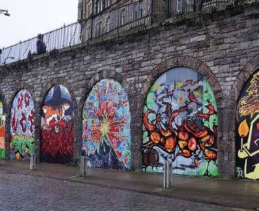
12 Landmark Opportunity Strategy Slateford Bridge - Slateford Snake Slateford Aqueduct is a major pinch point dividing the towpath in two. The aqueduct is a Scheduled Monument, therefore any changes will have to be sensitively managed with HES. Relaying the cobblestones to make the surface more even would be a relatively straight forward mitigation. These constraints at Slateford Aqueduct, present an opportunity to create a significant landmark of national importance to provide a Union Canal talking point. The aspirational idea is therefore to build a standalone structure parallel to the towpath between the aqueduct and the railway bridge. This structure creates a levelled alternative route across with extended ramped accessible connection and access to the Water of Leith Walkway perpendicular to the towpath underneath the aqueduct. The structure will be a landmark, an attraction, like other structures along the Scottish canal network, such as the Falkirk Wheel or Kelpies. Furthermore, the arches of the aqueduct and railway structures have an opportunity to be shops/ cafes/studios, incubator units and accessible workshops to create an urban destination. A place to be seen and a lively and linking space between east and west canal corridor. Water of Leith Walkway Slateford Aqueduct Union Canal Visualisation of alternative route at the Slateford Aqueduct Site between Slateford Aqueduct and Slateford Railway Bridge Union Canal Study


13 705 Union Canal Study 67


14 Elevated cycle path / Green route Another and more intrusive landmark opportunity is to create a elevated offroad cycle path following the Union Canal from Scott Russel Aqueduct to Lochrin Basin. The cycle path will be above the canal and meander through the city where it will duck down and connect to each or selected bridges along the canal. The overall idea is to create an attractive green route for cyclists and making travelling by bike the preferred option for commuters. Elevated cycle path Union Canal Study


15 Social improvement strategies The number of users of the canal and the towpath has increased over the years as the towpath offers space for a series of good outdoor activities. Unfortunately, many of the users are not aware of the current Towpath Code of Conduct by Scottish Canal and/or not aware of how to approach and show respect for other users while using a shared non-segregated path. The issues occur especially at access points to the towpath, at situations where different user groups want to pass each other and at bridge holes where sightlines are restricted. A Towpath Code of Conduct should educate and advise on how to react, behave and respect other towpath users. It should focus on the hierarchy of users and general use of shared paths and not just one user group. The strategy should be positive and focus on information and the right thing to do in certain situations. The Code of Conduct should be expressed Positive in its message Directed at those who behave responsibly not those who don t Targeted at all users, not only those cycling Provide information, not instruction A Code of Conduct for the use of shared paths could be combined with the Towpath Wayfinding and Signage Strategy and a wider strategy for shared nonsegregated space. The project team, therefore, advise that a code of conduct is to be developed and implemented wider than just concerning the Union Canal Towpath. There is a great opportunity to work with Sustrans on this for consultancy support around cultural/social change, and the towpath could offer a great opportunity as a test area for social improvement strategies. The revised Towpath Code of Conduct for the shared path could advise for: Keeping left User hierarchy Speeding cyclists Use of bells Dog walkers Joggers/Runners Boat/Rowing/Kayak clubs Visibility Thank you for using your bell Share with care Towpath Code of Conduct (current) 705 Union Canal Study 69
 Access Improvements (AI) Alternative Routes (AR) Placemaking (PM) Wayfinding & Signage Strategy Towpath Width Strategy Code of Conduct Strategy The study has identified such an")
16 Test Area The Project Team have recommended a Test Area, which can incorporate many of the proposed improvement strategies. Bridge holes (BH) Access Improvements (AI) Alternative Routes (AR) Placemaking (PM) Wayfinding & Signage Strategy Towpath Width Strategy Code of Conduct Strategy The study has identified such an opportunity from Harrison Park to Meggetland, and the aerial map on the opposite page gives an example of how the test area could be designed. The test area is a way to pilot the improvement strategies and an opportunity to get further feedback and input from users to make the proposals for the towpath most efficient and effective for the users. The elements suggested within the Test Area are relatively simple improvements, e.g. temporary street furniture for placemaking, colouring the surface to indicate the cycle path and mirrors at bridge holes. These can be seen a quick fixes which mean improvement which can be implemented at along the towpath quickly and easily as a starter on the general improvement of the towpath. The Project Team recognise that there is an urgent need to improve the towpath and the experience travelling along the canal, which is not fully met by the quick fixes. However at the same time, it is important to get started on some of the physical improvements to continue the constructive dialogue about the improvement strategies and to give the users the opportunity to be continually involved. The details of the test area, what it will include for physical elements, how long it will be live and how it is going to be evaluated are to be decided, and the Project Team sees it as a good opportunity for testing the strategies live before the are implemented throughout the length of the study area. Visualisation of how the test area could look like at Craiglockhart Primary School with temporary closing of Ashley Drive for Placemaking and a 3.0m wide coloured surface indicating the Alternative Route for bikes Union Canal Study

 & Towpath Widening Mirrors on the opposite wall of the bridge hole testing visual widening of the towpath.")
17 WS Sign guiding people to use the Alternative Route and info about the Alternative Route connecting back to the towpath at Ashley Terrace. AR Colouring the path blue to indicate the Alternative Route option for bikes. AI Removing the chicanes to create better access between existing path and the towpath WS Sign with welcome to the Test Area and introducing the strategy and where to find more information. BH (/2) & Towpath Widening Mirrors on the opposite wall of the bridge hole testing visual widening of the towpath. PM Testing closing the roads Ogilvie Terrace and Ashley Drive temporary for Placemaking with seating and planting elements. PM Testing Ogilvie Terrace temporary for Placemaking with seating and planting elements. AR Coloured surfaces at crossing point to make drivers aware of bikes and pedestrians crossing. AR 3.0m coloured blue cycle path on Ogilvie Terrace to indicate the Alternative Route option for bikes. BH (2/2) & Towpath Widening No mirrors on the opposite wall of the bridge hole to compare results of visual widening of the towpath. WS Sign with welcome to the Test Area and introducing the strategy and where to find more information. AR 3.0m coloured blue cycle path on Ogilvie Terrace to indicate the Alternative Route option for bikes. PM Testing Ashley Drive temporary for Placemaking with seating and planting elements. AR 3.0m coloured blue cycle path to indicate the Alternative Route option for bikes. 705 Union Canal Study 7
18 Union Canal Study
03 Opportunities and Strategies Union Canal Study 17
 03 Opportunities and Strategies 17015 Union Canal Study 17 Introduction This chapter summarises the issues, opportunities for improvement and proposed strategy outcomes of the study of the towpath. The
Survey Summary. 1. Overview. Pilot Implementation Survey Toronto Parks & Trails Wayfinding Strategy (Phase II) September 30 November 6, 2017
 September 30 November 6, 2017") Survey Summary Pilot Implementation Survey Toronto Parks & Trails Wayfinding Strategy (Phase II) September 30 November 6, 2017 1. Overview Between September 30 and November 6, 2017, the City of Toronto
Survey Summary Pilot Implementation Survey Toronto Parks & Trails Wayfinding Strategy (Phase II) September 30 November 6, 2017 1. Overview Between September 30 and November 6, 2017, the City of Toronto
YOU! Kensal Town Towpath Public Consultation WE WANT TO HEAR FROM YOU COULD WIN. Friday 21st December 2012 & Friday 8th February 2013
 London s greatest park, the historic canals and rivers, provide a cherished haven for people and wildlife. They are free for everyone to use and provide a welcome relief from busy city streets. We d like
Abbey Chesterton bridge Questions & Answers
 Abbey Chesterton bridge Questions & Answers Please click on links below to go to individual subjects: Bridge location and access routes Timescales Bridge details and accessibility Construction compound
Appendix 6 Fulbourn Greenway Review
 Appendix 6 Fulbourn Greenway Review Nigel Brigham & Associates A report for 1 Introduction This report is based on fieldwork carried out in 2016 to review the Greenway network around Cambridge as shown
Better Towpaths for Everyone. A national policy for sharing towpaths
 Better Towpaths for Everyone A national policy for sharing towpaths Contents Foreword 2 Introduction 3 Consultation 3 Principles of towpath use 4 Better infrastructure 5 Towpath Design Guide 5 Better signs
Next Generation Cycleway Design. Improving connectivity and cycling behaviours through design
 Next Generation Cycleway Design Improving connectivity and cycling behaviours through design Safe segregation between Place Users to offer improved safety and a defined space for each user group Elevated
Centurion Way Chichester
 Centurion Way Chichester Work book of plans to show details of the Centurion Way, its links, and potential developments and enhancements from linking to the South Downs National Park all the way to the
Regional Wayfinding Sign Strategy Thurston County Trails 2017
 Regional Wayfinding Sign Strategy Thurston County Trails 2017 Partners: Members and partnering organizations of the Thurston Thrives Community Design Action Team City of Lacey, City of Olympia, City of
Wimpole Estate Multi-use Trail 2017 Frequently asked questions
 Wimpole Estate Multi-use Trail 2017 Frequently asked questions Why does the National Trust want to create new trails? We want to play our part in helping to reconnect the nation with the outdoors. At the
Stainforth & Keadby Canal Installation of Multiuser Path
 Stainforth & Keadby Canal Installation of Multiuser Path Introduction North Lincolnshire Council has entered into an agreement with Canal & River Trust to develop proposals to introduce a multiuser path
Appendix L Technical Memorandum Aesthetics
 Technical Memorandum Aesthetics 1.0 AESTHETICS This section provides a discussion of the aesthetic resources in the vicinity of ARTIC. Aesthetics pertain to the elements that make a certain view pleasing
Access Statement for The Roald Dahl Museum and Story Centre
 Access Statement for The Roald Dahl Museum and Story Centre Introduction The Roald Dahl Museum and Story Centre is a small family-friendly Museum that welcomes all visitors. The Museum is situated in Great
Longmont to Boulder Regional Trail Jay Road Connection DRAFT FINAL REPORT
 Longmont to Boulder Regional Trail Jay Road Connection DRAFT FINAL REPORT December 2018 Project Summary Boulder County, Colorado, in partnership with the City of Boulder, is evaluating options for multi-use
Schedule of Planning Applications Committee Date: 23 May Reference: 06/18/0064/F Great Yarmouth Officer: Mr J Beck Expiry Date:
 Schedule of Planning Applications Committee Date: 23 May 2018 Reference: 06/18/0064/F Great Yarmouth Officer: Mr J Beck Expiry Date: 24-04-2018 Applicant: Proposal: Site: Mr Mavroudis Clear weather hoardings
promotion of the line-up and
 promotion of the line-up and communications 5 Promotion of the line-up Communications 5. 5. et communications general 5. To communicate better right from the approaches to the site The and of new products
TOWPATH MOWING GUIDELINES
 TOWPATH MOWING GUIDELINES 24 September 2007 CONTENTS Introduction Scope and Status of Guidelines Influences on the Guidelines Health and Safety Biodiversity INTRODUCTION Towpath management is a key issue
Prince Albert Road Towpath Ramp, Camden Feasibility Report
 Prince Albert Road Towpath Ramp, Camden Feasibility Report Function Location: RE-004 Date: 25 October 2012 Report No: 5016-UA003174-UT31R-03 Prince Albert Road Towpath Ramp, Camden Feasibility Report
DAVA WAY. Notes on multi-use access
 DAVA WAY Notes on multi-use access The Dava Way is a 24 mile (38km) waymarked long distance route based largely on the dismantled Highland Railway Line between Forres, near the Moray Coast in north-east
BHS ADVICE ON Dimensions of Width, Area and Height
 BHS ADVICE ON Dimensions of Width, Area and Height 2 In providing specifications for equestrian ways and facilities, The British Horse Society considers all equestrian users, which may result in a high
MORAY COAST TRAIL - Notes on multi-use access
 MORAY COAST TRAIL - Notes on multi-use access The Moray Coast Trail in the north-east of Scotland is one of Scotland s Great Trails. Approximately 50 miles long, the route links settlements between Findhorn
Flatford (including Bridge Cottage) Access Statement A small thatched cottage set in the countryside of the Dedham Vale.
 Access Statement A small thatched cottage set in the countryside of the Dedham Vale.") Flatford (including Bridge Cottage) Access Statement A small thatched cottage set in the countryside of the Dedham Vale. Contact details Bridge Cottage, Flatford, East Bergholt, Suffolk, CO7 6UL T: 01206
Flatford (including Bridge Cottage) Access Statement A small thatched cottage set in the countryside of the Dedham Vale. Contact details Bridge Cottage, Flatford, East Bergholt, Suffolk, CO7 6UL T: 01206
MPRB: Southwest LRT Community Advisory Committee Issues and Outcomes by Location Current to: 12 November 2010
 MPRB: Southwest LRT Community Advisory Committee Issues and Outcomes by Location Current to: 12 November 2010 This is a compilation of issues and outcomes identified by the CAC. It is a work in progress,
Appendix 3. Greenway Design Standards. The Whitemarsh Township Greenway Plan
 Appendix 3 Greenway Design Standards This chapter discusses two design standards for the greenway types discussed above. First, trail design standards are presented together with trailhead facilities and
NEWBORO AND PORTLAND HARBOUR REDVELOPMENT PLANS
 INTRODUCTION The Municipal docks in both Newboro and Portland were transferred to the Township of Rideau Lakes by Parks Canada in 2002. Little has been done to improve the docks physical condition or role
Access Statement for Marsham Court Hotel
 This access statement does not contain personal opinions as to our suitability for those with access needs, but aims to accurately describe the facilities and services that we offer all our guests/visitors.
ISOM & ISSOM forbidden symbol comparison
 & forbidden symbol comparison Forbidden symbols and their relatives Symbol 2000 (Long, Middle) 2007 (Sprint) 201 Impassable cliff An impassable cliff, quarry or earth bank (see 106) is shown with a 0.35
2. STAKEHOLDER FEEDBACK // What We Heard
 1. QUARRY ROAD TRAIL // Welcome to the Information Session PROJECT DESCRIPTION WHY WE ARE HERE Quarry Road Trail is a popular commuter trail and recreational area for Calgarians. 1. To report citizen feedback
FEASIBILITY CRITERIA
 This chapter describes the methodology and criteria used to evaluate the feasibility of developing trails throughout the study areas. Land availability, habitat sensitivity, roadway crossings and on-street
Welcome to the Cross County Trail Public Input Session!
 Welcome to the Cross County Trail Public Input Session! Please sign in on the table below! What are we doing here? Camden County has proposed a bicycle and pedestrian trail spanning across the entire county.
CITY OF EDINBURGH COUNCIL WRITTEN SUBMISSION
 CITY OF EDINBURGH COUNCIL Summary WRITTEN SUBMISSION Waverley and Haymarket are significant stations for Scotland as well as Edinburgh. The number of passengers using them has grown substantially in recent
Uniclass L534+L212. August home zones. paving PRECAST CONCRETE PAVING SOLUTIONS FOR TODAY S RESIDENTIAL STREET ENVIRONMENTS.
 August 2005 Uniclass L534+L212 paving home zones PRECAST CONCRETE PAVING SOLUTIONS FOR TODAY S RESIDENTIAL STREET ENVIRONMENTS www.paving.org.uk Home Zone Principles Home Zones are residential streets
Appendix 8 Sawston Greenway Review
 Appendix 8 Sawston Greenway Review Nigel Brigham & Associates A report for 1 Introduction This report is based on fieldwork carried out in 2016 to review the Greenway network around Cambridge as shown
COWAL WAY MULTI-USE ACCESS NOTES
 COWAL WAY MULTI-USE ACCESS NOTES The Cowal Way is a 57 mile long distance path. Starting at Portavadie, it winds its way up through the Cowal peninsula via Tighnabruich, Glendaruel, Strachur, Lochgoilhead
Hazardous Cattle Crossing: Use of Flashing Amber Lamps
 THE HIGHWAYS AGENCY THE SCOTTISH OFFICE DEVELOPMENT DEPARTMENT THE WELSH OFFICE Y SWYDDFA GYMREIG THE DEPARTMENT OF THE ENVIRONMENT FOR NORTHERN IRELAND Hazardous Cattle Crossing: Use of Flashing Amber
EASTNOR CASTLE Access Statement Issue date
 1. Introduction 1.1 Eastnor Castle is located in the Malvern Hills and surrounded by a large deer park, arboretum and lake. It is privately owned by the Hervey-Bathurst family. 1.2 Besides being a visitor
Consultation on the draft Traffic Signs Regulations and General Directions 2015 English Heritage response, 12/06/2014
 Consultation on the draft Traffic Signs Regulations and General Directions 2015 English Heritage response, 12/06/2014 Please find below the English Heritage response to the DfT Consultation on the draft
Greenbelt Route Signage Guidelines
 Greenbelt Route Signage Guidelines Revised March 31, 2015 Waterfront Regeneration Trust (416) 943-8080 info@wrtrust.com Greenbelt Foundation (416) 960-0001 info@greenbelt.ca www.greenbeltcycles.com Greenbelt
Berg-en-Dal Rest Camp, Kruger National Park Access for Guests with Mobility challenges
 Berg-en-Dal Rest Camp, Kruger National Park Access for Guests with Mobility challenges Berg-en-Dal is in the scenically attractive south-western hills of the park. It is best accessed through the Malelane
Trail # NW Tuesday, June DESIGN. Provide an Review the Provide an. Project Goals: System system. wayfinding
 I. Welcome / Introductions Bethany Creek Trail #2 Segment 3 Neighborhood Meeting #1 Bethany Presbyterian Church 15505 NW Springville Road, Portland, OR 97229 Tuesday, June 26, 2018 @ 6:00PM Meeting Minutes
Traffic Calming Measures
 REPUBLIC OF GHANA MINISTRY OF TRANSPORTATION Ghana Highway Authority Road Safety and Environment Division Traffic Calming Measures Design Guideline Version 1 / July 2007 Traffic Calming Measures Page 2
Appendix 9 Melbourn Greenway Review
 Appendix 9 Melbourn Greenway Review Nigel Brigham & Associates A report for 1 Introduction This report is based on fieldwork carried out in 2016 to review the Greenway network around Cambridge as shown
FLIGHT OPERATIONS PANEL (FLTOPSP)
") International Civil Aviation Organization FLTOPSP/1-WP/3 7/10/14 WORKING PAPER FLIGHT OPERATIONS PANEL (FLTOPSP) FIRST MEETING Montréal, 27 to 31 October 2014 Agenda Item 4: Active work programme items
International Civil Aviation Organization FLTOPSP/1-WP/3 7/10/14 WORKING PAPER FLIGHT OPERATIONS PANEL (FLTOPSP) FIRST MEETING Montréal, 27 to 31 October 2014 Agenda Item 4: Active work programme items
Provincial Railway Technical Standards
 GENERAL: INDEX: The standards and requirements listed in this document are intended for use on provincially regulated railway public grade crossings. These standards are considered the minimum requirements
ICAO Standards. Airfield Information Signs. ICAO Annex 14, 4th Edition Aerodrome Design and Operations
 ICAO Standards Airfield Information Signs ICAO Annex 14, 4th Edition Aerodrome Design and Operations Federal Aviation Administration U.S. Department of Transportation February 2004 ICAO Standards This
Trans Canada Trail Signage Guidelines MADE BY CANADA
 Trans Canada Trail Signage Guidelines MADE BY CANADA Mission: We will promote and assist in the development and use of the Trans Canada Trail by supporting success at the local level in the creation of
Gold Coast. Rapid Transit. Chapter twelve Social impact. Chapter content
 Gold Coast Rapid Transit Chapter twelve Social impact Chapter content Social impact assessment process...235 Existing community profile...237 Consultation...238 Social impacts and mitigation strategies...239
Location Hazard Description Our Controls What you and your party need to do Outside
 The following information is provided to assist visiting teachers and group leaders in completing their own risk assessment prior to their visit. It is not intended to be a replacement for a group leader-conducted
There are no planned or apparent developments near the crossing which may lead to a change or increase in use or risk.
 1.3 ENVIRONMENT Up side crossing approach Down side crossing approach It is a domestic level crossing which is located at the station. At CROWLE STATION level crossing the orientation of the road/path
Felixstowe Branch Line FAQ
 Felixstowe Branch Line FAQ How was the location of the track doubling work decided? We undertook a study to identify how to meet the freight demand along the Felixstowe Branch Line by modelling the route.
Those with Interest in the City of Cambridge Trail System
 Community Services Department City Hall 50 Dickson Street, P.O. Box 669 Cambridge ON N1R 5W8 Tel: 519-740-4681 July 20, 2010 To: Re: Those with Interest in the City of Cambridge Trail System City of Cambridge
A63 Castle Street, Hull HullBID Network Lunch 24 August 2017
 A63 Castle Street, Hull HullBID Network Lunch 24 August 2017 James D Leeming Senior Project Manager What we will cover today? Introduction to Highways England and the Road Investment Strategy A63 Scheme
5 MAP SPECIFICATION FOR SKI-ORIENTEERING
 5 MAP SPECIFICATION FOR SKI-ORIENTEERING 5.1 General Maps for ski orienteering are based on the specifications for foot-orienteering maps. However in order to meet the specific requirements put on the
Sir Craig Reedie Badminton Scotland Centre
 Sir Craig Reedie Badminton Scotland Centre A Guide to Access - Public Areas Written by Access Alba on behalf of Badminton Scotland October 2018 If you require this document in an alternative format, please
Access Statement for the Roman Baths
 Access Statement for the Roman Baths This access statement does not contain personal opinions as to our suitability for those with access needs, but aims to describe accurately the facilities and services
visits4u Case Studies: Historical Centre of Athens Athens, Greece
 visits4u Case Studies: Historical Centre of Athens Athens, Greece Historical Centre of Athens Athens, Greece Title: The Historical Centre of Athens as an Accessible Destination Description Tourism in Greece
1. Case Study Area and Character Sections
 ARAGO STREET 1. Case Study Area and Character Sections Case Study Area Calle Aragó is an important streets in the centre of Barcelona. The street belongs to the Eixample district. The origins of Barcelona
A Seagull Trust Union Canal Cruise East from Ratho Part 1, Bridge 15 to Bridge 13
 A Seagull Trust Union Canal Cruise East from Ratho Part 1, Bridge 15 to Bridge 13 Our cruise starts from the Seagull Trust Cruises Centre on the Union Canal at Ratho. Because our barges usually berth pointing
A TRANSPORT SYSTEM CONNECTING PEOPLE TO PLACES
 THE MAYOR'S VISION FOR TRANSPORT A TRANSPORT SYSTEM CONNECTING PEOPLE TO PLACES VISION We will build a transport system that works for everyone, connecting people to the places they want to go within the
Access Statement for RSPB Lochwinnoch
 Introduction This access statement does not contain personal opinions as to our suitability for those with access needs, but aims to accurately describe the facilities and services that we offer all our
APPENDIX D: SUSTAINABLE TRAIL DESIGN. APPENDICES Town of Chili Parks and Recreation Master Plan Update
 APPENDIX D: SUSTAINABLE TRAIL DESIGN APPENDICES Town of Chili Parks and Recreation Master Plan Update Sustainable Trail Construction Sustainable trails are defined by the US Forest Service as trails having
Hay Wood, Rowington and Baddesley Clinton - Warwickshire
 Hay Wood, Rowington and Baddesley Clinton - Warwickshire Starts at Lay-by alongside Hay Wood 2 hours 30 minutes 5.5miles 8.8km Leisurely ID: 0.683 Developed by: John Clift Checked by: Andy Page www.ramblersroutes.org
IEC BOARDWALK CYCLEWAY FEASIBILITY STUDY
 1 IEC BOARDWALK CYCLEWAY FEASIBILITY STUDY The aim of this study is to review the role and value of including a cycleway in the proposed boardwalk under the Island Eastern Corridor, and then to consider
Chapter The All-new, World-class Denver International Airport Identify Describe Know Describe Describe
 Chapter 10 The aerospace subject is very large and diverse. As seen in previous chapters, there are many subject areas. So far you have learned about history, weather, space and aerodynamics. Now you will
A travel description of the Brisbane Airport Domestic Terminal Precinct. Author: Mr Terry Boyle of the Tactual Mapping Committee (September 2013)
") A travel description of the Brisbane Airport Domestic Terminal Precinct Author: Mr Terry Boyle of the Tactual Mapping Committee (September 2013) Brisbane Airport is located approximately 18 kilometres
A travel description of the Brisbane Airport Domestic Terminal Precinct Author: Mr Terry Boyle of the Tactual Mapping Committee (September 2013) Brisbane Airport is located approximately 18 kilometres
Proposals for the Harrogate Road / New Line Junction Improvement Scheme. August / September Supported by:
 Proposals for the Harrogate / New Line Junction Improvement Scheme August / September 2016 Supported by: Introduction Key Benefits Proposals are currently being developed for changes to the junction of
DATE: 23 March, 2011 TO: Communities FROM: BlazeSports America. RE: Accessible Trails Checklist 1
 M E M O R A N D U M DATE: 23 March, 2011 TO: Communities FROM: BlazeSports America RE: Accessible Trails Checklist 1 The purpose of the Accessible Trails Checklist (below) is to help the community review
Sir Craig Reedie Badminton Scotland Centre A Guide to Access - Public Areas
 Sir Craig Reedie Badminton Scotland Centre A Guide to Access - Public Areas Photograph: Main Hall; Borders Badminton Group Written by Access Alba on behalf of BADMINTONscotland October 2018 1 If you require
Consideration will be given to other methods of compliance which may be presented to the Authority.
 Advisory Circular AC 139-10 Revision 1 Control of Obstacles 27 April 2007 General Civil Aviation Authority advisory circulars (AC) contain information about standards, practices and procedures that the
Chapter 6. Trail Design. Trail Design
 Chapter 6 Trail Design Trail Design The trail winds through a region rich in scenic beauty, cultural, and natural history. Volunteer landscape architects working with the Core and Planning Teams, have
Tallahassee-St. Marks Historic Railroad Trail
 Revitalizing a Historic Trail Designated as a National Recreation Trail, the 16-mile Tallahassee-St. Marks Historic Railroad Trail has been enjoyed by countless bicyclists, runners, and outdoor enthusiasts
Access Statement for Leighton Hall
 Access Statement for Leighton Hall Introduction Leighton Hall is located 3 miles from J35 of the M6. Brown tourism signs are in situate to bring you right to the door. There is plenty of parking, with
Hotel Accessibility Pack
 Hotel Accessibility Pack Hilton Imperial Dubrovnik is committed to providing equality of service for all our guests. Hotel accessibility pack is designed to answer your questions regarding accessibility
20mph Speed Limit Zones
 Traffic Advisory Leaflet 7/91 May 1991 20mph Speed Limit Zones Summary This leaflet illustrates the main steps in the procedures for the implementation of 20mph zones. It provides brief details on: the
Snowmobile GUIDELINES FOR TRAIL SIGNING
 STATE OF NEW HAMPSHIRE BUREAU OF TRAILS Snowmobile GUIDELINES FOR TRAIL SIGNING TRAIL FUNDED BY REGISTRATION FEES Table of Contents Introduction... Some Things to Take Into Consideration... BOT Provided
TOWPATH AND ACCESS IMPROVEMENTS BIRMINGHAM AND BLACK COUNTRY CANALS
 TOWPATH AND ACCESS IMPROVEMENTS BIRMINGHAM AND BLACK COUNTRY CANALS BACKGROUND Department for Transport grants Early 2013, the Parliamentary Under-Secretary for Transport, Norman Baker MP, announced 62m
Canal & River Trust Towpath Design
 Canal & River Trust Towpath Design Guidance for Towpath Design version 2 - January 2013 Contents: 1.0 Introduction 1.1 Introduction 1.2 Users 1.3 Purpose of the guidelines 1.4 A criteria-based approach
Port Macquarie-Hastings Pedestrian Access and Mobility Plan. Working Paper COMMUNITY ENGAGEMENT
 Port Macquarie-Hastings Pedestrian Access and Mobility Plan Working Paper COMMUNITY ENGAGEMENT December 2014 Table of Contents Table of Contents... 2 1 Introduction... 3 2 Submissions... 3 2.1 Stakeholder
YHA Malham Access Statement
 YHA (England & Wales) Trevelyan House, Dimple Road, Matlock, Derbyshire, DE4 3YH Tel. +44(0)1629 592 700 www.yha.org.uk YHA Malham Access Statement Introduction walking the Pennine Way, or just looking
Advisory Circular AC Laser Illumination Of Aircraft 21 May Revision 0
 Advisory Circular AC91-17 Revision 0 Laser Illumination Of Aircraft 21 May 2009 General Civil Aviation Authority Advisory Circulars contain information about standards, practices, and procedures that the
K SIGNAGE & TRAFFIC CONTROL. Table of Contents
 Table of Contents K1. ACCOMMODATION OF TRAFFIC... 1 K2. MINIMUM CONSTRUCTION SIGNING... 1 K3. SUBDIVISION SIGNS... 2 K4. TRAFFIC CONTROL DEVICES... 2 K4.1 Traffic Signs Regulations... 2 K4.2 Materials...
Chapter 14 Route Window C12 Mile End Park and Eleanor Street shafts. Transport for London
 Chapter 14 Route Window C12 Mile End Park and Eleanor Street shafts MILE END PARK AND ELEANOR STREET SHAFTS 14 Route Window C12 Mile End Park and Eleanor Street shafts Introduction 14.1 Crossrail s twin
PART VIII APPLICATION FOR REVISED SOUTH SIDE TRAFFIC MANAGEMENT WORKS TO FACILITATE LUAS BXD PLANNING REPORT ROADS & TRAFFIC DEPARTMENT
 PART VIII APPLICATION FOR REVISED SOUTH SIDE TRAFFIC MANAGEMENT WORKS TO FACILITATE LUAS BXD PLANNING REPORT ROADS & TRAFFIC DEPARTMENT NOVEMBER 2012 1.0 INTRODUCTION This report has been prepared in support
Dufferin Jog Elimination Project
 Project Project Status Update November 14 2007 Project History Planning Alternatives Criteria Measured Project Benefits Structural Configurations Considered Structural Design Considerations The Preferred
Walk 1. Cotswold Water Park. Gateway Centre to Cerney Wick, railway track to Lake 6, Gateway Centre.
 Cotswold Water ark Walk way A Swindon/ Cirencester Thomas and Severn Canal way to Cerney Wick, railway track to Lake, way. Spine Road East Hotel Time: hours (short walk km) Distance: km A level walk along
The National Path Demonstration Site
 The National Path Demonstration Site at Battleby an introductory guide Good paths are essential if people are to enjoy the outdoors. Thoughtful path design really opens up access but there s more to building
NOTICE OF REQUIREMENT: NZ TRANSPORT AGENCY: SH6 TARAMAKAU BRIDGE PROJECT
 1 July 2016 Planning Manager Westland District Council 36 Weld Street HOKITIKA Attn Alex Dunn Dear Alex NOTICE OF REQUIREMENT: NZ TRANSPORT AGENCY: SH6 TARAMAKAU BRIDGE PROJECT On 15 June 2016 you issued
EDEN PARK REDEVELOPMENT COMPLETED STADIUM DESIGN
 1 INTRODUCTION New Zealand was awarded the Rugby World Cup 2011 hosting rights in November 2005. A condition of the winning bid was the provision of a 60,000 seat stadium for the finals. New Zealand s
Glasgow to Edinburgh Trek map
 Glasgow to Edinburgh Trek map Route Stats: 62 miles (100km) with 700 metres of climbing Start time: 08:00 09:00 (registration open from 07:00) (Night trek start time 20:45 21:30) Checkpoints Distance Leave
SCHOOL ACCESS AUDIT CHECKLIST
 SCHOOL ACCESS AUDIT CHECKLIST School Access Audit Checklist The Echelford Primary School Question / Details Checklist 1 - Approach Routes & Street Furniture 1.1 - Is the school within convenient walking
Member-led Review of Cycling Infrastructure
 Member-led Review of Cycling Infrastructure Survey Results: A1 Cambridge to Royston June 17 cambridgeshire.gov.uk Contents 1. Introduction... 3. About you... 3.1 Age... 3. What is your gender?... 3.3 Do
Aerodrome Standards and Requirements Aeroplanes at or below 5700 kg MCTOW Non Air Transport Operations
 Advisory Circular AC139-7 & AC91-15 Aerodrome Standards and Requirements Aeroplanes at or below 5700 kg MCTOW Non Air Transport Operations Revision 4 18 December 2009 General Civil Aviation Authority Advisory
The Network Rail (Suffolk Level Crossing Reduction) Order
 Order") Aidan Dunn Interim Director of Resource Management Suffolk County Council Endeavour House 8 Russell Road Ipswich IP1 2BX Network Rail James Forbes House 27 Great Suffolk St London SE1 0NS 27 July 2017
Aidan Dunn Interim Director of Resource Management Suffolk County Council Endeavour House 8 Russell Road Ipswich IP1 2BX Network Rail James Forbes House 27 Great Suffolk St London SE1 0NS 27 July 2017
HMS Unicorn. Unique Ship / Remarkable History. Access Guide for HMS Unicorn HMS Unicorn Victoria Dock Dundee DD1 3BP
 HMS Unicorn Unique Ship / Remarkable History Access Guide for HMS Unicorn 2018 HMS Unicorn Victoria Dock Dundee DD1 3BP www.frigateunicorn.org For SAT NAV directions please use our postcode 01382 200900
TRAILS INTERSECTION SIGNS
 TRAILS INTERSECTION SIGNS Intersection signs shall be placed at all trail intersections and located a minimum of 3 from the edge of trail. The top of the post shall pitch away from the sign and trail.
Littlehaven Infant School
 Littlehaven Infant School Hawkesbourne Road Horsham, RH2 4EH School Travel Plan 208 Date reviewed: March 208 Completed By: Mrs Smailes Position: Deputy Headteacher Introduction Littlehaven Infant School
Route 29 Solutions Projects
 Your guide to the Route 29 Solutions Projects For full details & continued engagement please visit www.route29solutions.org The Route 29 Solutions Package is a $230 million investment into the improvement
3. COLTA / HUGA CONNECTIONS - PRELIMINARY
 9 3. COLTA / HUGA CONNECTIONS - PRELIMINARY 3.1 COLTA The Chain of Lakes Trail Association (COLTA) trail, formerly identified as the Chester Spur Line, was completed and opened for use in June 2011. The
Hudson Highlands Fjord Trail Draft Master Plan. April 29, 2015
 Hudson Highlands Fjord Trail Draft Master Plan April 29, 2015 Agenda Route Overview Proposed Segment Results of Community Survey on that Segment Next Steps Municipal Endorsement Environmental Review Implementation
URBAN DESIGN REPORT. Proposed Residential Development, Old Church Road, Caledon East
 Proposed Residential Development, Old Church Road, Caledon East TABLE CONTENTS: 1.0 DEVELOPMENT 1.1 Introduction-Analysis of Guiding Principles and Documents 1.2 Community Design and Architectural Design