Table of Contents. Appendices. List of Figures. Regional Naugatuck River Greenway Routing Study
|
|
|
- Matilda Melton
- 5 years ago
- Views:
Transcription
1
2
3
4 Table of Contents 1. Overview Mission and Goals Study Methodology Study Area Potential Greenway Routing Analysis Obstacles to Access and Connectivity (Gap Analysis) Affected Property Data General Construction Feasibility and Cost Brownfields and Environmental Constraints Safety and Security Permitting Issues Coordination with Other Studies Community Input Opportunities and Challenges Recommended Greenway Routing a. Recommended Greenway Routing Thomaston b. Recommended Greenway Routing Watertown c. Recommended Greenway Routing Waterbury d. Recommended Greenway Routing Naugatuck e. Recommended Greenway Routing Beacon Falls Use of the Rail Corridor Recommended Trail Section Limits Trail Section Prioritization Cost Estimate Community Phasing Plans Greenway Zoning Funding Sources Next Steps Appendices Appendix A Community Input Detailed Appendix B Land Parcel Inventory and Maps Appendix C Detailed Cost Estimate Tables Appendix C1 Thomaston Detailed Cost Estimate Tables Appendix C2 Watertown Detailed Cost Estimate Tables Appendix C3 Naugatuck Detailed Cost Estimate Tables Appendix C4 Beacon Falls Detailed Cost Estimate Tables List of Figures Figure 1: Map showing the five municipalities affected by this Study, though the alignment through Waterbury was determined separately Figure 2: Greenway Routing Analysis Thomaston Figure 3: Greenway Routing Analysis Watertown Final Regional Overview Report 1
5 Figure 4: Greenway Routing Analysis Naugatuck Figure 5: Greenway Routing Analysis Beacon Falls Figure 6: Opportunities and Challenges in Thomaston Figure 7: Opportunities and Challenges in Watertown Figure 8: Opportunities and Challenges in Naugatuck Figure 9: Opportunities and Challenges in Beacon Falls Figure 10: Recommended Greenway Routing Concept in Thomaston Figure 11: Existing (top) and proposed view looking southwest to the new at-grade crossing of Hill Road Figure 12: Site cross-section showing the recommended greenway alignment adjacent to the commercial properties between the river and South Main Street at far left Figure 13: View looking west to the Pine Hill/Waterbury Road intersection from below Route 8 (top) with proposed trail runs within the shoulder of the on ramp to Route 8 northbound Figure 14: Recommended Greenway Routing Concept in Watertown Figure 15: Trail cross-section north of Frost Bridge Road (Route 262) showing the greenway trail s relationship to the Naugatuck River, the Naugatuck Railroad and Route Figure 16: Greenway trail intersection with Frost Bridge Road (Route 262) and the Naugatuck Railroad. Improvements include: a greenway-user activated traffic signal and railroad crossing warning lights, signage and gates Figure 17: Trail cross-section south of Frost Bridge Road (Route 262) and potential new park space along the west bank of the Naugatuck River Figure 18: Potential greenway bridge between Watertown and Waterbury utilizing a rocky outcropping at the bend in the river adjacent to the intersection of Thomaston Avenue and Spruce Brook Road (not seen at right) Figure 19: Adopted Greenway Routing Concept in Waterbury Figure 20: Narrowing the wide travel lanes along Chase River Road provides the necessary space to accommodate the Waterbury NRG trail at the top of the river bank Figure 21: Unique lighting is recommended at key locations along the Waterbury NRG such as at the Jackson Street underpass where vehicles and bikes will share the street space Figure 22: The trail from Washington Avenue will run adjacent to Railroad Hill Avenue before crossing the river over the Eagle Street bridge Figure 23: Low traffic volumes along South Main Street provides an opportunity to reconfigure the roadway with three travel lanes to provide space for the trail Figure 24: Recommended Greenway Routing Concept in Naugatuck Figure 25: Cross-section showing the greenway trail at the edge of the Metro-North rail corridor Final Regional Overview Report
6 Figure 26: Proposed photographic simulation of the NRG trail alongside the Waterbury Branch rail line north of the Prospect Street Bridge, potentially as far north as the Bristol Street bridge in Waterbury Figure 27: New street trees, bike lanes and other sidewalk improvements will enhance the connection from the greenway trail to the train station along Water Street Figure 28: Site cross-section of the Naugatuck River showing the NRG on the left, adjacent to the Borough s proposed recreational fields Figure 29: Trail alignment at the south end of Naugatuck illustrating the proposed location for a new bridge across the Naugatuck River. (Note: Downtown Naugatuck is to the right, the State Forest to the left.) Figure 30: Recommended Greenway Routing Concept in Beacon Falls Figure 31: Cross-sectional view of the Naugatuck River Valley illustrating the large span bridge featured in the West Option Figure 32: Existing and photo-simulation view of the west end of the long-span bridge over Route 8, the river and the railroad line. The structural piers are configured to accommodate a second track in the future Figure 33: Existing and photo-simulation view of the rail corridor adjacent to Lopus Road (at left) between the O&G wash plant (background) and Toby s Pond and Recreational Park Figure 34: Rail with Trail Alignment Diagram for Watertown Figure 35: Rail with Trail Alignment Diagram for Naugatuck Figure 36: Rail with Trail Alignment Diagram for Beacon Falls Figure 37: Regional NRG Trail Priority Sections Figure 38: Land Parcel Inventory Map 1 for Thomaston Figure 39: Land Parcel Inventory Map 2 for Thomaston Figure 40: Land Parcel Inventory Map 3 for Thomaston/Watertown Figure 41: Land Parcel Inventory Map 4 for Thomaston/Watertown Figure 42: Land Parcel Inventory Map 5 for Naugatuck Figure 43: Land Parcel Inventory Map 6 for Naugatuck/Beacon Falls Figure 44: Land Parcel Inventory Map 7 for Naugatuck/Beacon Falls Figure 45: Land Parcel Inventory Map 8 for Beacon Falls Figure 46: Thomaston Trail Segment Cost Estimate Location Diagram Figure 47: Watertown Trail Segment Cost Estimate Location Diagram Figure 48: Naugatuck Trail Segment Cost Estimate Location Diagram Figure 49: Beacon Falls Trail Segment Cost Estimate Location Diagram List of Tables Table 1: Trail Section Prioritization Matrix Final Regional Overview Report 3
7 This page intentionally blank 4 Final Regional Overview Report
8 1. Overview Regional Naugatuck River Greenway Routing Study The Regional Naugatuck River Greenway Routing Study report recommends routing for the Naugatuck River Greenway trail through the Central Naugatuck Valley Region (CNVR) in West-Central Connecticut. The routing is the product of a year-long effort to study, analyze and develop routing recommendations for a Naugatuck River Greenway trail in Thomaston, Watertown, Naugatuck and Beacon Falls. The regional routing report also includes the recommended greenway in Waterbury, which was completed in a separate process. The overall goal of this report is to identify a route for a 22-mile long regional greenway trail in the CNVR. It is envisioned that this greenway will ultimately extend 44 miles from Torrington in the north to Derby in the south. The two primary goals of the Naugatuck River Greenway (NRG) are: 1) To develop a non-motorized transportation facility for walkers and cyclists. 2) To provide public access to the Naugatuck River. The NRG will provide residents throughout the region with a safe pedestrian and bicycle path that will connect to neighboring municipalities. The NRG will facilitate river access for fishing and small boat launches. The recommended alignment in Thomaston, Watertown, Naugatuck and Beacon Falls remains within viewing distance of the river for almost the entire proposed route. This allows users to appreciate the beauty of the Naugatuck River, even when being directly alongside of it is not possible or practical. In most areas along the length of the alignment, the preferred greenway route was apparent due to the relative ease of developing a trail along one side of the river versus the opposite bank. In a handful of locations, however, routing options were presented and narrowed down after input Figure 1: Map showing the five municipalities affected by this Study, though the alignment through Waterbury was determined separately. from the general public, the Regional Naugatuck River Greenway Committee, town officials and Council of Governments of the Central Naugatuck Valley (COGCNV) staff. For the Study, a greenway is defined as a corridor of land that connects people and nature together, and a trail is defined as a linear facility for non-motorized transportation and recreation. The future trail s design will be context sensitive; in some sections it may be a paved, shared-use path for pedestrians and bicyclists, while in others, the trail may be a rustic, natural-surface path amenable to equestrians. The Study also makes recommendations for the trail and related improvements such as trailheads, parking areas, canoe/kayak landings, on-street bike improvements and other spur connections. Final Regional Overview Report 5


9 The scenic quality of some sections of the Naugatuck River rivals that of rivers nearly anywhere in New England. less developed areas, such as northern New England or the Berkshires. Throughout the planning process, care was taken to ensure that recommendations coming from this Study fully considered recommendations from the Waterbury Naugatuck River Greenway Routing/ Feasibility Study as well as the various greenway-planning efforts occurring separately in the four study municipalities. The Regional Naugatuck River Greenway Routing Study also recommends connections to nearby parks, schools, state forests and town centers along the route. The Naugatuck River is the Central Naugatuck Valley Region's primary natural resource. While in many stretches the river has an industrial nature, in others it takes on the traits of a wild river running through far Today, there is a new appreciation of the value of this resource in the heart of Western Connecticut. COGCNV recognizes this portion of the Naugatuck River Greenway as the core of an inter-connected greenway system that will eventually connect to Oxford, Middlebury and Southbury via the Larkin State Park Trail and to Connecticut Forest and Park s Blue-Blazed hiking trail network. When complete, the Naugatuck River Greenway will: Serve as alternative green transportation facility. Provide recreation opportunities for residents and visitors. Improve the quality of life in local communities. Increase property values adjoining the greenway. Help retain and attract new businesses and residents. Raise awareness and help build appreciation of the value of the Naugatuck River. Greenway-oriented economic development adjacent to the Sue Grossman Still River Greenway in Torrington. (photo: Peter Kisselburgh) 6 Final Regional Overview Report
10 2. Mission and Goals The following Mission and Goals provide a measurable set of guidelines for the development of the Naugatuck River Greenway. Mission: Goal 1: Goal 2: Goal 3: Goal 4: Goal 5: Develop an interconnected greenway trail along the Naugatuck River corridor from Thomaston to Beacon Falls that incorporates existing and planned trails and open spaces, and connects to nearby parks, schools, downtowns, public transportation and other destinations in order to create opportunities for non-motorized transportation and for communities to reconnect with the natural environment along the river. Connect Thomaston, Watertown, Waterbury, Naugatuck and Beacon Falls with a contiguous multiuse greenway trail. Furthermore, access points and connectivity to commuter and tourist train stations and bus routes are necessary for the proposed trail to be a successful transportation and recreational facility. Increase the number of people walking and bicycling for transportation and recreation and the number of children walking and bicycling to school in the Central Naugatuck Valley Region, helping to reduce traffic congestion, greenhouse-gas emissions and sedentary lifestyles. Support each community s economic development efforts by routing the greenway to serve their downtown areas. Incorporate context-sensitive design in the planning and development of the greenway trail. The trail will be sensitive to local conditions. Individual sections of the trail may be designed as a rustic, natural-surface trail or as a paved, shared-use path based on local conditions. Some stretches could be designed to encourage equestrians, depending on local conditions. Interpretive elements will reflect each community s unique heritage and culture, while a consistent greenway logo will establish a consistent identity along the entire greenway trail. Reconnect the communities of the Central Naugatuck Valley Region to the Naugatuck River. Provide access to the river for recreational, educational and public safety purposes. Encourage municipalities and residents to better protect the river corridor. Final Regional Overview Report 7

11 3. Study Methodology The Regional Naugatuck River Greenway Routing Study followed a methodology that included community workshops, site walks, stakeholder meetings, reviews of relevant planning documents and field observations to identify short-term and long-term alternatives for development of the regional greenway. Planning tools such as GIS-based data analysis and review of aerial photography were employed as well. The mission and goals outlined in the previous section guided the planning process. A series of site walks and meetings with stakeholders in each of the communities occurred in the fall of 2009 and continued on an as-needed basis through the summer of Public workshops for the datagathering stage were held on November 17 and 18, 2009 in Naugatuck and Thomaston, respectively and on March 23 and 24, 2010 in Beacon Falls and Watertown, respectively. Additionally, the project website ( was maintained throughout the duration of the Study. A core element of the Routing Study was to identify gaps in the current greenway system and propose short- and long-term alternatives for closing the gaps and connecting existing or planned sections of the greenway. Gaps were evaluated for: Land ownership issues User accessibility Environmental concerns Physical barriers such as topography, major roads and rail lines, etc. Permitability, constructability and cost Adjacent planned development Community support or opposition Overall character, including view opportunities Adjacency to points of interest Potential or lack of access points After the Gap Evaluation, an analysis of opportunities and challenges within the project corridor was conducted to refine the routing alternatives. Working with COGCNV planners and the Naugatuck River Greenway Committee, the alternatives were narrowed down to a recommended greenway alignment that had the community s support. In conjunction with the routing recommendations, a phasing plan for implementation, along with cost estimates for each phase were developed. The phasing recommendations take into account that greenway planning, design and development often occurs over extended periods of time and early successes can help to maintain overall project support, funding and momentum. The planning and conceptual design of the trail follows appropriate trail-related design guidelines. For example, the typical cross-section for the NRG is based on the AASHTO 1999 Guide for the Development of 8 Final Regional Overview Report One of the break-out group tables at the community meeting held in Thomaston on November 18, 2009.


12 Bicycle Facilities, which recommends a ten foot-wide shared-use path with two-foot soft shoulders (14 feet total) with a minimum dimension of eight feet to clear pinch points. This does not preclude, however, the possibility that some sections of the trail may include stretches that are narrower and made of permeable surfaces due to local conditions and other constraints. 4. Study Area The study area is a 22-mile corridor along the Naugatuck River within the municipalities of Thomaston, Watertown, Waterbury, Naugatuck and Beacon Falls. The corridor is approximately one-half to one mile in width but can vary to allow for a full range of opportunities for consideration, including the potential for trails on both sides of the river or along roads, highways and rail corridors. Recommendations for the greenway alignment begin in the north at the Thomaston Dam in Thomaston and extend south to Toby s Pond and Recreational Park in Beacon Falls. Connections further north to Torrington and south to Derby are being coordinated by the Litchfield Hills Council of Elected Officials and the Valley Council of Governments, respectively. Within the nearly four-mile long river corridor in Thomaston, the study area focused on an approximately half-mile wide corridor between North/South Main Street on the west bank and the rail line on the east bank and the Route 222 / Hill Road corridor to the Thomaston Dam. Within the corridor, the study area is varied from an environmental and land-use point of view. At the northern-most end, the river corridor runs through federal lands that are undeveloped except for the dam structure. Running downriver (south), the character of the river s edges becomes more industrial as it passes through downtown Thomaston, where factories and mills were built in the 19 th century. Just north of downtown, Route 8 passes over the river and turns to the south, running along the east bank for nearly two miles until it crossing again to the west side of the river. South of downtown, on the west bank, there are a collection of commercial and industrial uses along the river, most fronting either South Main or River streets. Downriver from the Reynolds Bridge, the Naugatuck River corridor then proceeds into Watertown as it cuts a channel into the hills of the Mattatuck State Forest. Within the river corridor in Watertown, the study area for a potential greenway trail was limited to an approximately half-mile wide corridor between Route 8 on the west to Waterbury Road (in Thomaston) on the east. Additionally, on-road bicycle improvements were studied along Industrial uses along the river in downtown Thomaston. View of the rail line through the wooded area north of Frost Bridge Road in Watertown. roadways perpendicular to the river corridor, extending west to the center of Watertown. The more-thanthree mile length of this corridor is relatively consistent and comprised primarily of wooded areas cut by the rail line, the Route 8 corridor and a dirt access road. Downriver from the Thomaston-Watertown Town Line along Branch Brook, the Naugatuck cuts a channel into the hills of the Mattatuck State Forest. In this section, with Watertown fronting the west bank and Thomaston the east, there is very Final Regional Overview Report 9


13 limited development because of the steep slopes and the presence of the rail line and Route 8. The state highway is at a much higher grade than the river in most places and its visual and auditory impact is relatively minimal. The beautiful scenery continues until the Waterbury line, where the Waterbury Industrial Commons flood wall dominates the riverscape. Within the 3.3-mile long river corridor in Naugatuck, the study area includes a variety of settings and contexts. At the very north end, both river banks are lined with a relatively-dense canopy trees as neither the rail line nor any busy roadways sit immediately adjacent to the river. On the west bank, the rail line is separated from the river by an abandoned rail right-of-way and a stand of mature trees until it reaches downtown. At the south end of Platts Mill Road, however, Route 8 runs very close to the river and dominates the east riverbank for approximately a mile until Linden Park. From north to south, Linden Park is the first of a trio of existing and future park spaces along the river. This includes Breen Field and the proposed recreation fields at the former Uniroyal/Naugatuck Chemical plant site. In between the riverside park spaces, there is a mix of commercial and industrial land uses fronting the river with downtown and residential neighborhoods sitting beyond. Along Maple Street there are a few large parcel slated for redevelopment, including those slated for the mixed-use Renaissance Center Development project. South of General Datacom and Breen Field, the river corridor includes the former Uniroyal site and sewage treatment plant on the west bank and Route 8 with the Grove and St. James cemeteries beyond on the east bank. At the far southern end of the Borough the corridor includes a commuter park-and-ride lot and Cotton Hollow Field along Cross Street. Also located there is the old Route 8 right-of-way that provides access to the eastern half of the Naugatuck State Forest. Within the 4.5-mile long river corridor in Beacon Falls, the northern half of the study area for a potential greenway trail was limited to an approximately half-mile wide river corridor between the steeply-sloping hills of the Naugatuck State Forest. Beyond the river corridor, however, on-road bicycle improvements and hiking trail enhancements were studied within the State Forest. On the eastern side of the river valley, lies the current Route 8 Expressway and an abandoned portion of Old River corridor looking north from the Whittemore Bridge in Naugatuck with southbound Route 8 exit ramp at right. Where Route 8 runs away from the Naugatuck River, the river retains its natural setting through much of Beacon Falls. Route 8. To the west lies the Metro-North Railroad Waterbury Branch and a single land, unpaved access road (Cold Spring Road). There are also a number of Blue-Blazed hiking trails in the Naugatuck State 10 Final Regional Overview Report
14 Forest, including the popular High Rock trail on the west side. Limited parking and poor access keep the number of hikers and mountain bikers to a relative minimum on the eastern portion of the State Forest. South of the State Forest boundary, the study area flattens out considerably and the adjacent land uses become more varied. Flanking the river in this area are residential neighborhoods and small-scale commercial sites on the east bank while industrial users are more prevalent on the west. Despite this, there is still a verdant quality to the river landscape as most buildings are set back from the river and the riverbank retains its natural look. While Route 8 hugs the river through the State Forest, through downtown Route 8 sits away from the edge of the river and does not dominate the river landscape. Route 8 crosses back to the east and the Naugatuck River turns sharply at Riverbend Park. The corridor ends at Toby s Pond and Recreational Park, the southern terminus of the study area. Final Regional Overview Report 11

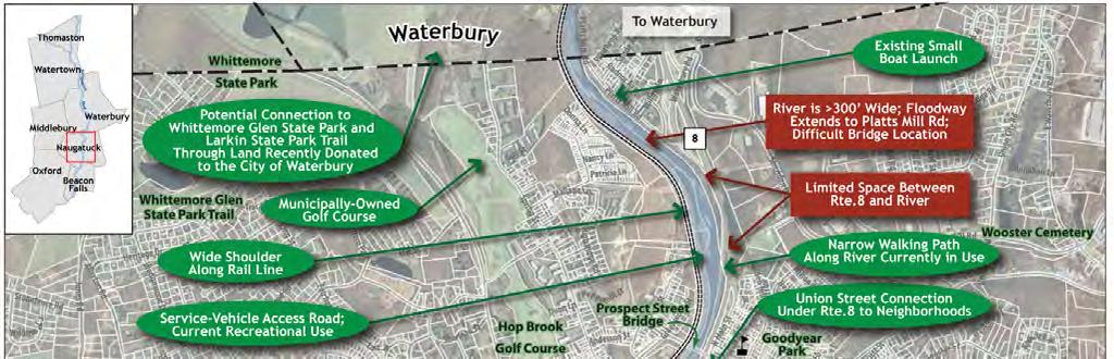
15 5. Potential Greenway Routing Analysis The analysis of Potential Greenway Routes is based on meetings and walking tours with stakeholders, field observations and the examinations of aerial photos and GIS-based maps. This analysis is based on the long-term desire to incorporate a 8-12 wide stone dust or paved trail in close proximity to the Naugatuck River, but a narrower dirt hiking trail or on-street bike lanes in the short term are not precluded. These may be necessary to avoid difficult stretches where property ownership issues, engineering challenges or environmental constraints exist. The four Greenway Routing Analysis Maps (Figures 2-5, pages 14 to 17) include: Identification of cultural and historic destinations and scenic areas that should be connected to the greenway. Existing, planned or proposed local greenways. Portions of the corridor for which no apparent routing options currently exist, i.e. gaps. Identification of potential spurs and loops that connect to other greenways, amenities and destinations. For the latter two bullets points, the maps feature elements along the river that present existing and potential conditions along the Naugatuck River. Potential conditions and example situations from the region are presented below: No apparent routing option along the river typically due to the placement of Route 8 along the edge of the river or very steep slopes that may present significant challenges (note that this does not preclude the possibility of a narrow, short-term path as mentioned above). Example: North of the Prospect Street Bridge in Naugatuck where Route 8 runs very close to the river s edge. Potential rail with trail along active rail line an active rail line with an adjacent level shelf, unutilized spur or maintenance way that is potentially wide enough to accommodate the greenway trail with an appropriate setback (ideally but potentially as low as 10 ) from the rail line. Example: The rail corridor through parts of Naugatuck may offer an opportunity for a rail-with-trail greenway section. 12 Final Regional Overview Report


16 Potential trail adjacent to the river portions of the riverbank where spatial and topographical constraints do not prevent the routing of the trail close to the river s edge. Example: Portions of the greenway trail within Toby s Pond and Recreational Park are likely to run adjacent to the river. Potential connection along existing access road or street rights of way (ROW) areas where the greenway may be able to use an adjacent access road or the portion of an adjacent road ROW with sufficient width to accommodate a trail. Example: A dirt maintenance roadway that runs between the rail line and Route 8 in Watertown is an opportunity for the trail. Potential spur trail/street improvements these are on-road improvements that may involve creating bicycle lanes and improved pedestrian facilities such as sidewalks. These on-road improvements can help to connect the greenway to other trails, schools, cultural destinations and downtown areas. Example: Streetscape enhancements along Elm Street in Thomaston will improve connections between the future Naugatuck River Greenway and the Clock Walk. Final Regional Overview Report 13

17 Figure 2: Greenway Routing Analysis Thomaston. 14 Final Regional Overview Report


18 Figure 3: Greenway Routing Analysis Watertown. Final Regional Overview Report 15

19 Figure 4: Greenway Routing Analysis Naugatuck. 16 Final Regional Overview Report

20 Figure 5: Greenway Routing Analysis Beacon Falls. Final Regional Overview Report 17

21 6. Obstacles to Access and Connectivity (Gap Analysis) Throughout the 22-mile NRG corridor, there are a number of obstacles to establishing a contiguous trail along the Naugatuck River. Thomaston Beginning at the north end of the corridor, it is possible to walk along a series of informal trails along the east bank of the river, below the Thomaston Dam, between the Vista Picnic Area and the Hill Road (Route 222) bridge over the Naugatuck River. However, access downriver (south) from this area is difficult on foot or bike on either riverbank because of private property, the Route 8 interchange (exit 40) and the rail line. There is only one river access point between Route 222 and the East Main Street Bridge via Railroad Street Annex. An unused access road through the Plume & Atwood site provides some opportunity for access in the future. South of the East Main Street Bridge, steep slopes and private property create obstacles to access immediately adjacent to the river. Following the Clock Walk along Elm Street is recommended for the greenway as an alternative to the steep riverfront corridor. The east bank of the river from here to the Reynolds Bridge is constrained by the close proximity of the rail line, Route 8 and the Naugatuck River. The west bank does offer some opportunities for connectivity, but some obstacles are present including private property along the river, South Main Street s narrow right of way and the on/off ramps for Route 8 (exit 38). Watertown Throughout the more-than-three mile corridor in Watertown, there are a handful of obstacles including Branch Brook at the Town Line, busy traffic along Frost Bridge Road (Rte. 262), and the need to cross the river to connect to the recommended alignment of the greenway in Waterbury. The future trail will also run for nearly a two mile stretch from Reynolds Bridge Road to Frost Bridge Road without access to an adjacent or intersecting public street. This may create a safety perception problem as potential greenway users could feel anxious about the lack of access points in and out of the trail in the case of an emergency. Additional obstacles exist for those wishing to access the NRG corridor by car or transit, since no parking or trail head currently exist in Watertown. Only one access point is recommended in Watertown proper, a primary trailhead and parking area to be incorporated into the planned CT Transit Waterbury Bus Maintenance Garage along Frost Bridge Road. The new bus garage will also provide transit access from Waterbury to this portion of the greenway route. Trailheads located just north of Branch Brook (at the Thomaston Sewer Plant) and adjacent to the railroad bridge over the Naugatuck River in Thomaston, will also provide access to the trail. The recommended NRG trail route will follow an existing unpaved access road that runs between Route 8 and the Naugatuck River for over two miles. Currently, the access road is used occasionally by dirt bikes and all-terrain vehicles, so decisions will need to be made in the future with regards to which users motorized, non-motorized or both have the 18 Final Regional Overview Report Site of the future CT Transit Waterbury Bus Maintenance Garage off of Frost Bridge Road.
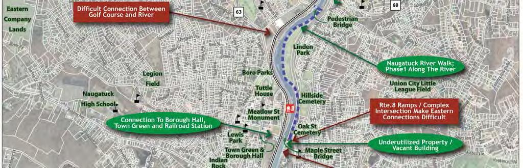
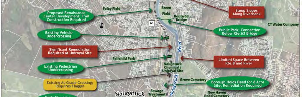
22 right to use the greenway trail. This dirt access road terminates at Frost Bridge Road and the rail line continues south to Waterbury in a right of way with an adjacent shoulder that could potentially accommodate a trail. While this corridor works well for a linear greenway trail, the presence of Route 8 to the west and the topographical conditions makes connections to adjacent neighborhoods difficult, except along Route 262. At the south end of this section, a pedestrian-bike bridge will be needed to connect to the future NRG trail in Waterbury. On the east side of the river from Reynolds Bridge to Frost Bridge (Town of Thomaston property), potential access for non-motorized users is also significantly constrained. For much of this stretch, either Waterbury Road or the rail line (or both) lie very close to the river s east bank. In some spots, the road pulls away from the river and provides access for those on foot, particularly the blue blazed Whitestone Cliff Trail as it passes over Frost Bridge and turns north before passing under Waterbury Road. South of Frost Bridge, Waterbury Road runs in a relatively narrow corridor with some pinch points, but nothing so extreme as to completely preclude a trail route along Waterbury Road. Waterbury An analysis of obstacles in Waterbury s 7-mile greenway corridor was conducted separately as part of the Waterbury Naugatuck River Greenway Routing/Feasibility Study. The greenway routing recommendations from that study are presented in chapter 15c of this report. Naugatuck Throughout the 3.3-mile corridor in Naugatuck, there are a handful of obstacles to access and connectivity for a seamless Naugatuck River Greenway trail. The primary obstacles are the line along the west bank of the river and the Route 8 expressway on the east bank. Starting from the Waterbury line, few constraints to NRG access exist along Platts Mill Road until it meets Route 8. Portions of Route 8 pass very close to the river s east bank, providing only space for a narrow hiking trail from Platt s Mill Road until the north end of Linden Park. On the west side, the active rail line runs along the river from the Waterbury/Naugatuck boundary to Maple Street, where it passes overhead on a trestle. Long stretches of the rail line include a wide shoulder or a separated dirt access road for service vehicles. This offers some potential for trail connectivity in the future such as connecting north to Waterbury via the Bristol Street Bridge. Immediately south of downtown Naugatuck, private property along the river or the rail line creates obstacles to river access on both banks. However, the South Main Street right of way is a simple way to avoid the private properties on the east side and to access Breen Field. Access through the park works well for cars, walkers and bikes. At the southern end of Breen Field, Route 8 rejoins the river and runs immediately adjacent to it, in some places cantilevering out over it. Route 8 remains an obstacle to riverside access on the east bank for the remaining stretch of the river in Naugatuck. On the west bank, the obstacles created by the rail line continue to the Naugatuck State Forest, but access for vehicles, bikes and pedestrians is limited but physically possible on a pair of underpasses below the rail line on the former Uniroyal/Naugatuck Chemical site. Final Regional Overview Report 19

23 Beacon Falls Obstacles to river access and connectivity continue within Beacon Falls proper, though some portions of the Naugatuck River are accessible to the community. Old Route 8/North Main Street on the east bank provides access along the sidewalk from Volunteer Park to Veteran s Park. South of the Depot Street Bridge, a relatively narrow shoulder of the four-lane road will soon be transformed into a greenway link within the right of way from the bridge to South Main Street s intersection with Route 42. South of this spot, traffic increases and South Main becomes a more significant obstacle for nonmotorized movement along the river or from the adjacent neighborhood to the northeast. From Riverbend Park on the east bank south to the town line, a collection of homes and other private property, as well as the Route 8, present obstacles to river access. On the west bank of the river across from the center of Beacon Falls, numerous privately-owned parcels limit connectivity along the river. Railroad Avenue runs parallel to the uses along the west bank of the river. This street brings motorist and hikers to the small parking area that serves the existing hiking trail behind the Murtha Industrial Park and bring hikers back to Railroad Avenue and the Route 8 overpass. South of this point Railroad Avenue becomes a private road that accesses O&G Industries wash plant property. This private road runs parallel to the Metro-North Railroad. The private road ends at Toby s Pond and Recreational Park. 7. Affected Property Data The parcels falling within or adjacent to the study area boundary have been identified and shown in Figures provided in Appendix B. A table with parcel size and property-owner information within each municipality is also provided. The parcel inventory is intended to facilitate future correspondence between the municipality and affected property owners. The parcel tables were developed from the COGCNV GIS parcel database. In some instances the information may be incomplete. In Thomaston, a total of 16 parcels have been identified within the study corridor, not including public rights of way. Key parcels of public land within the corridor include: U.S. Army Corps of Engineer s land surrounding the Thomaston Dam Town of Thomaston Fire Station CTDOT s Route 8 right of way CTDOT / Naugatuck Railroad s rail corridor CTDOT District IV facility (on South Main Street) and salt shed area Mattatuck State Forest In Watertown, a total of four parcels have been identified within the study corridor, not including public rights of way. The Town Assessor assisted with parcel identification. Key parcels of public land within the corridor include: 20 Final Regional Overview Report The railroad tracks that run along the river for the length of the State Forest complicate the ability to place the NRG on the west bank.
24 Former drive-in theater site, home to the proposed CT Transit Waterbury Bus Maintenance Garage along Frost Bridge Road. The Connecticut Department of Transportation s (CTDOT) Route 8 and rail corridor property from the Thomaston-Watertown Town Line to Frost Bridge Road. South of Frost Bridge Road, the Route 8 right of way diverts to the west and is not relevant to the NRG alignment but the rail corridor continues to run alongside the river is owned by the state. The rail line is leased by the Naugatuck Railroad from the CTDOT. In Naugatuck, a total of 13 parcels have been identified within the study corridor, not including public rights of way. Key parcels of public land within the corridor include: Rail corridor between Bristol Street (Waterbury) and the General Pulaski foot bridge Linden Park Breen Field Portions of the former Uniroyal site (in negotiation) Naugatuck State Forest In Beacon Falls, a total of ten parcels have been identified within the study corridor, not including public rights of way. Key parcels of public land within the corridor include: CTDOT s Route 8 right of way CTDOT-owned property (various segments within town limits) Riverbend Park (maintained by Trout Unlimited) Volunteer Park Veteran s Park O&G Industries hiking trail around the Murtha Industrial Park (privately owned with easement) Toby s Pond and Recreational Park 8. General Construction Feasibility and Cost Experience on other greenway projects can be used to infer a planning level estimate of expected construction cost for the Naugatuck River Greenway. For a typical greenway with conventional structure types in a rural setting, expected greenway construction costs for either a paved or stone dust path range from $0.75 to $1.25 million per mile. Many factors will affect final cost including construction materials, commodity prices, property impacts of the selected alignment and other undetermined issues. Costs for a greenway trail along the Naugatuck River corridor, as with most greenway projects, will be largely driven by the requirements of structural components (e.g., bridges, pile-supported walkways, etc.). Within Thomaston town limits, no expensive new bridges over the Naugatuck River are required. However, a handful of other design elements will require engineered solution that will increase the cost of some individual segments of the NRG. For instance, to provide a route for the trail across the East Main Bridge, the narrow south sidewalk is recommended for widening to 10-12, a significant cost. Also, while far less expensive than Naugatuck River crossings, two or three new brook bridges are recommended in Thomaston. Also, a possible trail section on piles will be needed to bypass the wetland area behind the auto dealership between the Route 8 on and off ramps at South Main Street. The option to avoid these wetlands could be expensive as well as, requiring multiple retaining walls to keep the NRG along the river and below Route 8. Completing the entire corridor within Watertown town limits will require one new crossing of the Naugatuck River and one short crossing of Branch Brook. Off-setting the costs of this bridge are long Final Regional Overview Report 21
25 stretches of comparatively inexpensive trail that can be constructed at the existing grade of the dirt access road between Branch Brook and Frost Bridge Road. Another expensive component in Watertown is anticipated to be a potential elevated rail crossing at the northern end of the former drive-in movie site. Here, construction of a trail as part of the CT Transit bus maintenance facility and the approved, but yet un-built, material processing facility is expected, but current plans have the trail dead end at the northern end of the site. Combined with the primary greenway trail along the unpaved access road, a bridge over the tracks could create a short walking/biking loop and eliminate the need for pedestrians and bicyclists to use the existing at-grade railroad crossing on Frost Bridge Road for those wishing to walk or bike closer to the river. The NRG through the Borough of Naugatuck is expected to capitalize on several linear assets including the scheduled and funded Naugatuck Riverwalk project, existing rail bed, Linden Park, Breen Field and the former Uniroyal site. These relatively low-cost segments will offset the three, more-expensive river crossings that will be required for a continuous trail from one end of the Borough to the other. Completing the entire corridor within Beacon Falls town limits will require an expensive solution to pass through the Naugatuck State Forest, utilizing either bracketed, cantilevered sections or a large-scale river/route 8/railroad track bridge crossing. Another expensive component will be a new trail bridge over the Naugatuck River either adjacent to the Pines Bridge or near the Route 42 intersection of South Main Street and Bethany Road. The rest of the NRG in Beacon Falls will rely on the relativelystraightforward development of a trail through existing parks and along road or rail rights-of-way. 9. Brownfields and Environmental Constraints Land use within the 22-mile greenway corridor varies from industrial and mixed commercial/residential sites to sparsely developed rural areas to undeveloped forestland. Each of the various land uses brings its own set of environmental challenges. In urbanized environments with a history of industry like the Central Naugatuck Valley Region, it is common to find sites contaminated with oils or hazardous materials. Older development frequently included use of urban fill materials (e.g., brick, block and asphalt within a soil and ash matrix). Due to the presence of ash and asphalt within the urban fill, it is common to find pollutants such as heavy metals and polycyclic aromatic hydrocarbons (compounds commonly found in petroleum and combustion byproducts) within urban fill materials. These concerns will likely complicate the acquisition of parcels for greenway development. As definitive designs for the various greenway segments are developed, the designer should identify parcels with known or potential historic releases of contaminants. This will allow trail designs to incorporate appropriate mitigation measures. A first order assessment of potential contamination can be made by reviewing the Connecticut Department of Environmental Protection s (CTDEP) List of Contaminated or Potentially Contaminated Sites in Connecticut and List of Significant Environmental Hazards Reported to the DEP. As of September 2009 and February 2010, respectively, no sites along the greenway corridor were listed as contaminated by the CTDEP. However, these lists are not exhaustive and only provide information about sites that CTDEP is aware of. If warranted, a more detailed evaluation in the form of a Phase I/II Environmental Site Assessment may need to be undertaken. Constructing portions of the greenway may require disturbing polluted soil. Special consideration should be given to the following: 22 Final Regional Overview Report
26 o Soil disposal: If excess soil is generated during the construction of the trail, it may require special handling and disposal due to the presence of pollutants. We recommend that the trail be designed in a manner to reduce the amount of excess soil generated during the project to mitigate the potential for excessive costs associated with polluted soil disposal. o Potential for exposure: Although the greenway may be paved, thereby mitigating the potential for users to come into contact with pollutants directly beneath the trail, soil located along the shoulders of the trail could provide a potential exposure pathway. Surficial soil quality testing may reveal these conditions and permit the designer to incorporate mitigating measures (e.g., separation fabrics, clean fill, etc.). In less developed areas, environmental constraints relate less to mitigating man-made contamination and more to protecting and managing natural resources. Sensitive resources include: wetlands, flood plains, endangered or threatened species habitat, steep slopes or erosive soils and archeological resources. In these resource areas, a special effort should be made to maintain and/or re-establish riparian buffers adjacent to the river or wetlands. These buffers help protect water quality, lower water temperatures and provide wildlife corridors. Where the greenway is proposed to cross an area identified as a potential endangered or threatened species habitat, a review by the CTDEP should be sought early in the design process. The CTDEP will advise the municipality on appropriate measures to protect the critical habitat. If the CTDEP determines that the proposed project is likely to impact a listed threatened or endangered species, or significant natural communities, department staff will provide recommendations to avoid or minimize impacts to these species and habitats. CTDEP permit analysts reviewing the project environmental permit applications will consider these recommendations during their review and typically incorporate appropriate conditions as part of the permit. Where appropriate, municipalities are encouraged to work with their design professionals to incorporate low-impact design (LID) principles into the greenway. LID allows for more natural stormwater drainage patterns and promotes groundwater recharge. It helps to decrease the adverse effects of development upon our water resources. Common LID measures include permeable pavements, rain gardens, biofiltration swales, etc. These measures may not be appropriate, however, in areas where underlying soils are polluted. 10. Safety and Security Trail safety is a major concern of both trail users and those whose property is adjacent to a greenway trail. Emergency vehicles access to the NRG is paramount and the alignment and access point locations were planned with this in mind. All of the municipalities along the corridor should plan for regular security patrols for the sections of the trail within their jurisdictions and develop an emergency response plan for police, fire and ambulance service. Creating a safe trail environment goes beyond design and law enforcement, however and should involve the entire community. The most effective and most visible deterrent to illegal activity on the NRG will be the presence of legitimate trail users. Getting as many eyes on the trail as possible is the most effective deterrent to undesirable activity. There are several components to accomplish this: Provide good access to the trail Access ranges from providing conveniently-located trailheads along the greenway, to encouraging the development of sidewalks and bike facilities along public roadways that connect to, or intersect, the NRG. Access points should be inviting and signed to welcome the public onto the trail. The proposed greenway route includes multiple access points in all of the municipalities with the exception of Final Regional Overview Report 23
27 Watertown. There, direct access to the NRG will be intermittent with parking areas or trailheads located at the Thomaston Town Line and at Frost Bridge Road, a gap of approximately two miles. Because of this, the Town will need to place additional emphasis on some of the other Safety and Security components listed below. Good visibility from adjacent neighbors Neighbors adjacent to the trail can potentially provide 24-hour surveillance of the trail and can become an ally to local police departments. Though some screening and setback of the trail may be needed for privacy of adjacent neighbors, complete blocking out of the trail from view of adjacent businesses should be discouraged. This eliminates the potential of neighbors eyes on the trail, and could result in a tunnel effect along the trail. High level of maintenance A well maintained trail sends a message that the community cares about the public space. This message alone will discourage undesirable activity along the trail. Programmed events Community events along the NRG will help increase public awareness and thereby attract more people to use the trail. Various civic organizations can help organize public events along the trail which will increase support. Events might include a day-long trail cleanup or a series of short interpretive walks led by knowledgeable residents or a naturalist. These events could be coordinated with the Connecticut Forest and Park Trail or other environmental organizations in the region. Community projects The support generated for the NRG could be further capitalized by involving neighbors and friends of the trail in a community project. Ideas for community projects include volunteer planting events, art projects and interpretive research projects. These community projects create a sense of ownership along the greenway and serve as a deterrent to undesirable activity along the trail. Adopt-a-Trail Program Nearby businesses, community institutions and residential neighbors often see the benefit of their involvement in trail development and maintenance. Businesses and developers may view the trail as an integral piece of their site planning and may be willing to take on some level of responsibility for the trail as well. Creation of an adopt-a-trail program should be explored to capitalize on this opportunity and build civic pride in the greenway. 11. Permitting Issues The construction of the greenway along the Naugatuck River will require permits from various agencies. A brief description of each anticipated permit is provided below. It should be noted that each permit may not be required for each individual section of the greenway trail. Municipal Inland Wetlands and Watercourses Permit for Regulated Activities Basis: Threshold: Delegated authority from the State based on Connecticut General Statutes. Any regulated activity within a State regulated wetland or upland review area. Can also be required if the activity is in an upland area, drains to a regulated wetland area and/or is deemed to have a potential impact on the wetland. 24 Final Regional Overview Report
28 Process: Time Line: Application must be made to the Municipality and most include a Connecticut Department of Environmental Protection Reporting Form. At the first meeting after application is received, it is formally accepted by the Commission. This begins the time periods as defined in the State Statutes. If the proposed activity is deemed to be a potentially significant activity, then a public hearing must be held before a decision can be made by the Commission. If the activity is found to have no significant impact, then the Commission may hold a public hearing, if it is found to be in the public good, or may render a decision without holding a hearing. Following the formal publication of the decision, there is a 15-day appeal period. Normally takes three to six months, depending on whether a public hearing is required. Application must be submitted prior to or concurrent with the Planning and Zoning Permit, if required. Municipal Planning and Zoning or Municipal Zoning Department Permit (Site Plan Approval) Basis: Threshold: Process: Time Line: Local authority granted under Connecticut General Statutes, but based on local bylaws and regulations. Any significant earthwork or work requiring a building permit. A Zoning permit may not be required for basic greenway trail projects. This should be discussed with each municipality s Planning and Zoning staff once the corridor and proposed construction methods are sufficiently defined. Application is made to the Municipality. At the first meeting after the application is received, it is formally accepted by the Commission. This begins the time periods as defined in the State Statues and local bylaws. Certain activities require a special permit which requires a public hearing and must be held before a decision can be made by the Commission. Also, the Commission cannot make a decision until the Inland Wetlands Commission has made a decision. Following the formal publication of the decision, there is a 15-day appeal period. Plans must normally be approximately 70% construction document level in order to contain sufficient information to gain approvals. Normally takes three to six months, following submission, depending on whether a public hearing is required. The permit application cannot be submitted prior to the application for Inland Wetlands, although they can be submitted on the same day. FEMA Floodplain Development and Conditional Letter of Map Revision Basis: Threshold: Process: Federal law with some review authority delegated to the municipality. Any earthwork or construction within a designated flood plain; work over, or in a designated floodway. A floodplain permit is required before construction begins within any Special Flood Hazard Area (SFHA), or any flood-prone areas if no SFHA has been defined. Permits are required to ensure that the proposed development project meets the requirements of the National Flood Insurance Program and the community's floodplain management ordinance. In Connecticut, this review is usually performed by the Planning and Zoning or Wetlands Commissions. Generally, passive recreation, such as bicycle and pedestrian trails, are allowed as permitted use in flood-prone areas. However, if the proposed construction affects the elevation or horizontal spread of flood waters, the applicant may need to apply for a Conditional Letter of Map Change (CLOMR). Application is made to FEMA with the concurrence of the municipality. The application must demonstrate that Final Regional Overview Report 25
29 Time Line: the water surface elevation will not increase by more than one foot (cumulatively with other developments) in the flood plain or by any amount in the regulatory floodway through use of hydraulic modeling software. It should be noted that some municipalities have floodplain-management regulation more restrictive than these requirements. Following construction, an application must be made for a Letter of Map Revision (LOMR) depicting actual as-built conditions and modeling demonstrating that the data presented in the application is valid. Normally takes twelve to eighteen months for CLOMR. Connecticut Flood Management Certification (FMC) Basis: Threshold: Process: Time Line: Connecticut General Statutes and CTDEP Regulations. All State of Connecticut actions in or affecting floodplains or natural or man-made storm drainage facilities, including projects undertaken by municipalities with funding provided by the State. Application is made to the Connecticut Department of Environmental Protection (CTDEP). Upon receipt of a request for CTDEP approval of a state agency's flood management certification, the application is assigned to a project manager and is reviewed for sufficiency. If the application is sufficient, a detailed technical review is initiated. These reviews consist of an evaluation of the technical documentation provided in the application as well as an independent assessment of the site and of the project's consistency with the flood management standards and criteria. Normally processed within three months. If other CTDEP approvals are required, the FMC will be processed concurrently with the other applications. Stream Channel Encroachment Permit Basis: Threshold: Process: Time Line: State regulation of specific stream channels as defined by Connecticut General Statutes and CTDEP Regulations. Any earthwork within the stream channel encroachment line. Application is made to the CTDEP. Application must include hydrologic analysis proving that activity does not negatively impact flood water or impede flow within the channel. Normally takes six to twelve months depending upon the nature of the proposed construction. Connecticut Department of Environmental Protection General Permit for the Discharge of Stormwater and Dewatering Wastewater from Construction Activities Basis: Threshold: Process: Time Line: Connecticut General Statutes and CTDEP Regulations. Compliance with the General Permit is required for all projects that disturb one or more acres of total land area. Projects with five or more total acres of disturbance, regardless of phase must also file a registration with the CTDEP. Projects exceeding ten acres of total disturbance must obtain an approval of registration, including a detailed review of the required Stormwater Pollution Control Plan. Application is made to the CTDEP. Must be submitted at least sixty days prior to the start of construction. 26 Final Regional Overview Report
30 Army Corps of Engineers (ACOE) Permit Basis: Threshold: Category I Category II Category III Process: Time Line: Section 404 of the Clean Water Act There are three categories of ACOE permits based on the total area of disturbance of federally regulated wetlands. The federal definition of wetland is different from the Connecticut definition. Although the limits of both federal and state wetland tend to be the same, there are sometimes differences. ACOE jurisdiction is triggered by any fill-in, or secondary impact to, a federally regulated wetland. If the ACOE has jurisdiction, then the category of permit is decided based on the total direct and secondary impacts to wetlands. Direct impacts include earthwork operations. Secondary impacts can include changes in drainage patterns or groundwater hydrology, clearing/cutting of vegetation, or alteration of shade patterns. General Permit (less than 5,000 square feet of disturbance) Programmatic General Permit (PGP) (5,000 square feet to 1 acre of disturbance) Individual Permit (one acre, or more, of disturbance) For Category I, there is no application required. For Category II and III permits, application is made to the ACOE. Review is conducted jointly by the ACOE and the Connecticut DEP (see CT 401 Water Quality Permit). Additional review by the U.S. Fish and Wildlife and other federal agencies is conducted for Category II and III permits. Category II permits can be changed to Category III if requested by reviewing agencies based on potential impacts of the wetlands or wildlife habitat. Category II permits normally take six to nine months depending on complexity, quality/function of wetlands, and surrounding habitats. Category III can take one year or more. Category II and III permits cannot be granted until the CT DEP issues a 401 Water Quality Permit. Connecticut Section 401 Water Quality Certification Basis: Threshold: Process: Time Line: Federal authority, under the Clean Waters Act, delegated to the State of Connecticut. Category II or III ACOE Permit, or any State of Connecticut Project. Application to the ACOE is jointly reviewed by the Connecticut Department of Environmental Protection (CTDEP). The CTDEP often requires additional information to be submitted which is not required by the ACOE. Normally takes four to six months. This certification must be granted before the ACOE can issue a Category II or III permit. 12. Coordination with Other Studies Along with the Regional Naugatuck River Greenway Routing Study, other relevant studies have recently been completed or are occurring concurrently. In some cases, some of these studies have had an impact on the routing decisions for the NRG and recommendations from this Study have led to proposal alterations to the other studies. The other studies include: The I-84/Route 8 Interchange Study will guide CTDOT in the long-term multi-billion-dollar project to completely rebuild the Mix Master I-84/Rte. 8 interchange near downtown Waterbury. Options that were studied and recommended may have an impact on the Final Regional Overview Report 27
31 recommended routing of the Greenway trail through the core of Waterbury but are unlikely to effect the alignment in the four municipalities which are the focus of this Study. The Route 8 Study is a planning effort that looked at ways to improve traffic flow and motorist safety at exits along Route 8 in Seymour, Beacon Falls and Naugatuck. All design recommendations are being classified as near-, medium- or long-term improvements. From north to south, potential projects that are most relevant for the Regional Naugatuck River Greenway Routing Study include: o Elimination of the Route 8 south-bound on-ramp from Platts Mill Road and the adjacent south-bound off ramp to create a frontage road-like connection from South Main Street in Waterbury and North Main Street in Naugatuck. Within this section, depending on traffic speeds and lane width, the new frontage road could be used by bicyclists for local connections. o Widening the west side of Route 8 just north of the Prospect Street Bridge will bring the edge of the highway closer to the Naugatuck River, creating a tighter pinch point than the one that exists today. o Widening the North Main/Union City/City Hill intersection in Naugatuck to improve traffic flow but could make any potential pedestrian or bike connection to the neighborhoods to the east more difficult. o Adding a shared-use path adjacent to Route 8 along the east bank of the river, just south of Linden Park in Naugatuck (overlaps with the Borough s existing greenway plans). o Removal of the Route 8 south-bound access ramp from South Main Street, via Route 63, potentially opening up the opportunity for the greenway trail to use this de-commissioned stretch of road bed adjacent to Breen Field. o Adding a roundabout at exit 25 in Naugatuck to better accommodate on and off-ramp traffic intermingling with Cross Street traffic (will need to be coordinated with the NRG alignment that will cross the southern leg of the roundabout). o Adding a left-turn pocket to the Depot Street bridge within the existing median along Old Route 8 in Beacon Falls. o Suggesting decommissioning traffic lanes along Route 42 in Beacon Falls, making the existing three- and four-lane state highway a two-lane road (with landscaped divider). This potential road diet recommendation provides space for a greenway connection along the east bank of the river from Pines Bridge up to South Main Street. The Waterbury and New Canaan Branch Lines Feasibility Study was a CTDOT managed study to investigate and recommended improvements for two branch lines of Metro-North commuter rail network. The draft study s recommendations may impact the routing of the greenway in two ways: o Passing sidings are recommended for Beacon Falls in the Naugatuck State Forest and adjacent to Toby s Pond Recreational Park. A passing siding adjacent to Toby s Pond may make it more difficult for connecting the greenway trail to the portion of the greenway proposed as part of the Rte 42- Rte 67 Connector Road. o Full signalization of the branch line to Waterbury is recommended. Signalization may require installation of cables, control boxers, and signal lights along the rail corridor, which could create obstacles for the rails with trails sections of the greenway trail. 28 Final Regional Overview Report
32 o A new Naugatuck Train Station is proposed on top of the Maple Street railroad overpass. This new station would have direct access to the greenway trail via the recommended pedestrian and bicycle improvements for the Whittemore Bridge. The Waterbury Naugatuck River Greenway Routing and Feasibility Study recommends a hybrid greenway alignment through the city that utilizes public and private property along the east and west banks of the river, numerous bridges, and a handful of roadway corridors to link difficult-to-bridge gaps along the river. The Study includes numerous loops and spur connections to important nearby destinations, as well as nature trails that run adjacent to the wider, paved greenway trail. At the north end, the Waterbury Greenway is proposed to terminate at the City Line adjacent to Thomaston Avenue with a long-term recommendation for a new bridge to span the river at this location, connecting with the trail running north to Watertown. At the south end, the Waterbury Greenway runs along the Platts Mill Road right of way and terminates at the existing small boat launch at the Naugatuck/Waterbury line. The Connecticut Bicycle and Pedestrian Transportation Plan was updated by the Connecticut Department of Transportation in The effort includes a state-wide plan and detailed map that illustrates the state s policies, existing facilities and future needs for safe and efficient travel by bike or by foot. The official bike map includes two cross-state routes that cross the Naugatuck River Valley within the Regional Greenway study area. These include a route through Thomaston from the west along Route 109, along South Main and out of Thomaston via Hill Road. In Naugatuck, the cross-state route follows Route 63 through the Borough. The Route 42/67 Connector Road Study is a current study managed by the Valley Council of Governments in cooperation with COGCNV, Beacon Falls, Seymour and CTDOT. The Study investigates the feasibility of constructing a connector road between Route 42 in Beacon Falls to Route 67 in Seymour, west of the Naugatuck River. The connector road will provide access to land for development in both towns and will be paralleled by the Naugatuck River Greenway. This section of the NRG trail will be an important part of the mixed-used development envisioned for this corridor. The greenway would be designed as part of this connector road, if the project moves into a design phase. Final Regional Overview Report 29


33 13. Community Input The Council of Governments of the Central Naugatuck Valley (COGCNV) hosted two pairs of public workshops for the Naugatuck River Greenway Routing Study. A workshop was held in each of the four greenway study municipalities. The first public workshops were held on November 17 and 18, 2009 in Naugatuck and Thomaston, respectively. The purpose of the first set of workshops was to gather input from all four communities to assist in determining opportunities and challenges along the corridor and potential routing options for the greenway trail. The meeting on the 17th was focused on the issues and routing in both Naugatuck and Beacon Falls, while the next night, discussion focused on the issues and routing in Watertown and Thomaston Community members discuss greenway planning issues at the March 23, 2010 meeting at Woodland Regional High School in Beacon Falls. The second of the two pairs of public workshops were held on March 23 and 24, 2010 in Beacon Falls and Watertown, respectively. The purpose of these meetings was to gather input from the four communities on the proposed preliminary routing as well as areas where they would like to see additional amenities along the Naugatuck River Greenway. Overall, the four community meetings, combined with other stakeholder meetings and site walks, provided the COGCNV and the consultant team with valuable input on routing recommendations, design options and property-ownership issues. The team also learned of the important local connections to adjacent neighborhoods and commercial areas outside of the corridor. Additional trail spurs and other connections were added to the recommendations as a result. One attendee even suggested the clever idea of using the 22-mile greenway, plus some spurs, as the route for the Naugatuck River Marathon in the future. Draft routing maps were also posted on the project website. Comments on the greenway routing maps were received at the workshops, via and by U.S. Mail. Press releases were published for both sets of workshops in the Republican American and other town newspapers. Articles were written and published on the workshops, including references to the project website. Video of the Thomaston workshop was posted to the Republican American website. Elected officials from Naugatuck and Beacon Falls pose next to NRG analysis maps displayed at the November 2010 public meetings. 30 Final Regional Overview Report
34 Subsequent to the community meetings, members of the Connecticut Horse Council and the Connecticut Equine Advisory Council investigated key trail connections that currently exist in the Naugatuck River corridor area. They provided a detailed memo to the COGCNV and mapped the connections in a GIS database, some of which helped the consultant team recommend spur-trail links important to equestrians. A final public meeting was held on September 14, 2010 at the COGCNV s offices in Waterbury. The completed draft study was presented to the Regional Planning Commission and members of the public in attendance. Members of the public and RPC commissions voiced support for the greenway study. One member of the public emphasized the importance of designing the greenway to not take away from the beauty of the Naugatuck River. 14. Opportunities and Challenges Part of the community and stakeholder meetings, field work and analysis during the easy stages of this Study included the documentation and analysis of existing opportunities and challenges to the development of a greenway trail within the four municipalities along the Central Naugatuck River Valley. This analysis is shown in the series of diagrammatic maps, Figures 6-9, on the following pages. Final Regional Overview Report 31

35 Figure 6: Opportunities and Challenges in Thomaston. 32 Final Regional Overview Report

36 Figure 7: Opportunities and Challenges in Watertown. Final Regional Overview Report 33

37 Figure 8: Opportunities and Challenges in Naugatuck. 34 Final Regional Overview Report

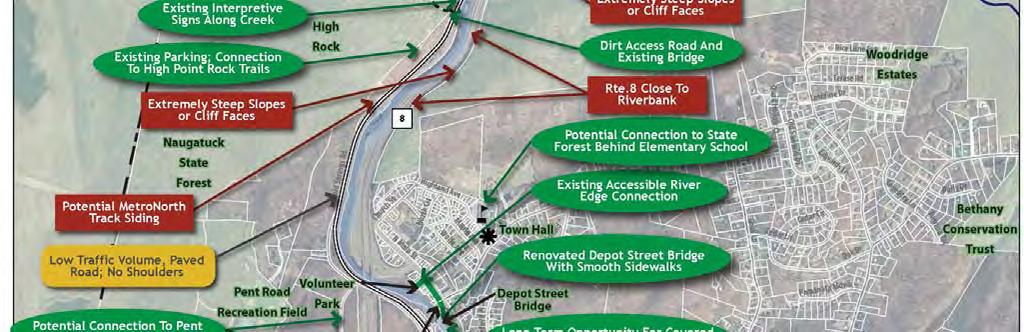
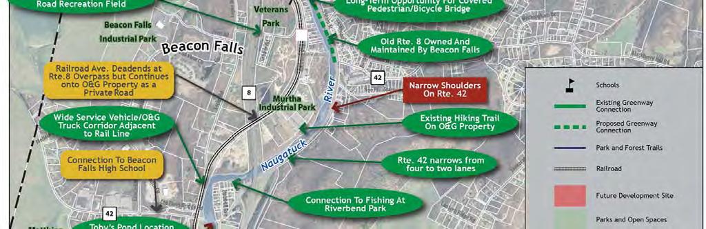
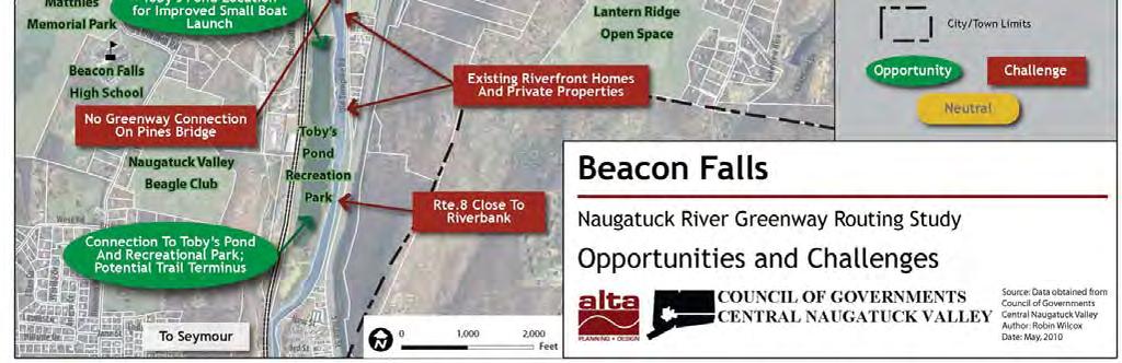
38 Figure 9: Opportunities and Challenges in Beacon Falls. Final Regional Overview Report 35
39 15. Recommended Greenway Routing 36 Final Regional Overview Report

40 15a. Recommended Greenway Routing Thomaston See inset map on following page Final Regional Overview Report 37

41 Figure 10: Recommended Greenway Routing Concept in Thomaston. 38 Final Regional Overview Report


42 The Naugatuck River Greenway (NRG) within the Town of Thomaston will provide a diverse experience for walkers, runners and cyclists. The 4.5 mile trail includes portions set adjacent to existing roadways, soft-surface pathways close to the river and streets shared with low-speed traffic. The route will provide connections to many attractions in town: the Thomaston Dam, the Railroad Museum of New England, the Clock Walk, the Thomaston Opera House and the Blue-Blazed Mattatuck Trail at the Watertown line. Trail-side amenities will be provided along the route, including: small parking lots, picnic areas, small boat launches (for canoes and kayaks), rest stops, seating, water fountains, public art, and interpretive signage and kiosks. Future greenway connections south to Watertown and Waterbury and north to Litchfield and Harwinton will also provide safe corridors for walking and biking and encourage additional nonmotorized trips in town. A. Recommended Greenway Trail Alignment Until a future greenway connection is developed to the north, the northern terminus of the recommended Naugatuck River Greenway alignment is the Vista Picnic Area at the U.S. Army Corps of Engineers Thomaston Dam. To discourage trail use by ATVs and other motorized vehicles, signs and bollards will be needed here and at all other trailheads. Neither are a panacea however and enforcement will be needed as well to ensure that only non-motorized uses occur on the NRG. Existing Hill Road dry bridge over the railroad line just south of the Thomaston Dam The greenway trail will offer improved connections from the river to downtown Thomaston. From the picnic area, the greenway runs along the west side of Hill Road (Route 222), separated from motorized traffic by a crash barrier. To accommodate the 8-10 trail and 1-2 buffers on each side (10-14 total), the travel lanes on Hill Road are narrowed to 11 with 1-2 shoulders and the trail utilizes the unpaved shoulder area along the west edge of the pavement. Because some areas feature a slope immediately adjacent to the road, a small retaining wall will help to create a flat enough grade for the paved pathway. At the bridge location over the railroad line, a new trail bridge will span the tracks using the sloping abutments as structural supports. West of the rail line, the path will continue another and then cross Hill Road where sight lines are adequate, between the two relatively sharp turns to the east and west. This roadway crossing features a high-visibility crosswalk and a median island in the center of the roadway to slow traffic and create a refuge for pedestrians and cyclists between the two travel lanes (see Figure 11 on the following page). To the north, a recommended walking trail loop along an undeveloped section of the Naugatuck will showcase the natural beauty of the river. Final Regional Overview Report 39

43 From the east side of Hill Road, the greenway will travel directly south along an easement through a wedge of private property set between Hill Road, the rail line and the river. The south end of this property borders two residential properties, and care must be taken to ensure the privacy of those living in both houses. The trail will either loop to the east of the houses at the base of the railroad embankment within the state rail corridor or to the west, as close to the river as practicable. In either case, a security fence, low wall and/or dense landscaping should be considered to ensure the maximum physical and visual separation between the residences and trail users. In the years leading up to the development of the NRG, the Town of Thomaston should consider purchase of this residential property in the event it is for sale. (At the very least, the Town should purchase rights of first refusal from the current owner.) If and when this occurs, the Town could then resell the property with an easement legally attached as a pre-existing Figure 11: Existing (top) and proposed view looking southwest to the new at-grade crossing of Hill Road. condition to the subsequent owner of the property. This short stretch of trail within either the stateowned rail corridor or adjacent to the river will bring the trail to Railroad Annex, a public right of way that passes below Route 8. Here, trail users will share the roadway as the route continues to the south and connects to the access road that leads to the former Plume & Atwood industrial site. Currently, this private roadway is closed by a locked gate but is in good condition and runs close to the river. The most likely connection to the East Main Bridge will occur on a trail that runs relatively close to the river through the historic Plume & Atwood parcel when the site is redeveloped in the future (presumably as a commercial, institutional or residential project). Because this is likely a long term scenario, on-road improvements for cyclists wider shoulders, signage, etc. are recommended along North Main Street from Hill Road to East Main Street. A connection for the trail was studied along the rail corridor adjacent to Plume & Atwood but was determined to be infeasible due to the difficulty of relocating the existing siding, the challenges or using an at-grade crossing for the NRG and the Railroad Museum of New England s desire to incorporate another rail siding in the future. 40 Final Regional Overview Report

 behind the former Seth Thomas")
44 From the Plume & Atwood site, the greenway alignment continues under the East Main Bridge to the Railroad Museum and then up onto the Bridge via the existing off ramp. Improvements are needed on both the off ramp and the East Main Street Bridge over the Naugatuck River. A wider sidewalk and improved railings will provide an improved pedestrian and bike connection to downtown Thomaston and the Town s historic Clock Walk. The Elm Street portion of the Clock Walk will receive dual designation as the NRG to provide a connection through downtown and back to the river (via Maple Street) behind the former Seth Thomas Factory building. Elm Street will be enhanced with an on-street bikeway (striped shoulders and signage), sidewalk improvements and traffic calming features such as speed humps or curb bump-outs, where appropriate, to help slow traffic. A wider south sidewalk and other enhancements to the East Main Bridge over the river will improve connections from downtown to the Railroad Museum. The NRG will run downriver (south) along the west bank of the Naugatuck from the Seth Thomas Factory parking lot for at least a half mile. The trail will utilize easements at the far east end of a handful of properties that front the river: the former Seth Thomas Factory building, the Thomaston Fire Station (Town-owned property), a self-storage building, CTDOT s district headquarters (State-owned property), and a handful of privately-owned commercial and retail properties. Nearly all of the commercial properties front South Main and are set back a good distance from the river, providing space to accommodate the greenway trail with 2 shoulders. Within this stretch there are opportunities for a small boat launch behind the CTDOT building, a trailhead adjacent to the fire station and picnic areas in multiple locations. At least one new trail bridge will connect the greenway across a small ravine and brook adjacent to the former Seth Thomas Factory and over wetland areas. Figure 12: Site cross-section showing the recommended greenway alignment adjacent to the commercial properties between the river and South Main Street at far left. Final Regional Overview Report 41


45 Where the NRG approaches the south-bound Route 8 exit 38 off ramp, two options for the trail alignment are recommended for further study. One follows along the edge of the curving off ramp to the signalized intersection at South Main Street and Route 6. After crossing the off-ramp (where cars stop for a red light), the trail will wind behind the auto dealership on either the edge of the dealership s parking area or along the edge of the Route 8 embankment, in order to avoid the existing wetland. It will then cross at the signalized intersection that provides access to the north-bound Route 8 on-ramp. Narrowing the wide travel lane and shoulder of the on-ramp will provide the space for the trail to pass under Route 8 and connect back again to the west bank of the Naugatuck. The second option in this area will maintain the trail along the west river bank below the two decks of Route 8 and connect to the CTDOT salt shed area after running within the shoulder of the exit 38 north-bound on ramp for a short distance. From the CTDOT maintenance yard and salt shed, the NRG will continue south through the CTDOT-owned property and connect below Reynolds Bridge. The spacing of the structural arches below the bridge requires the use of two bays for the trail, creating a split in the trail with two narrower segments running side-by-side. Reynolds Bridge, with its vaulted concrete arches, will be a landmark of engineering and architectural interest along the NRG and should be interpreted with a sign or plaque. Heading south from the bridge, the trail will cross Old Waterbury Road at its intersection with Reynolds Bridge Road, a low-volume road that could provide a comfortable shared environment for vehicles and bicycles. A new sidewalk will line the east side of the road to provide access for walkers. Where Reynolds Bridge Road intersects York Road, the greenway route will divert from the right-of-way and enter the wooded area to the south. Here, the Mattatuck Trail will be utilized as the NRG, requiring a widened and improved surface to accommodate walkers and bicycles (whether this stretch of the greenway can be ADA accessible needs further exploration in subsequent design work for the greenway). The improved Mattatuck Trail will link with the Watertown portion of the greenway via an new trail bridge over Branch Brook, the boundary between Watertown and Thomaston. From this location, a soft-surface spur trail will connect along the former trolley bed that runs west to Route 6 and Black Rock State Park. Drivers wishing to enter the NRG at this location will have the opportunity to park at a recommended parking lot for up to 25 cars at the Thomaston Sewer Plant. From The Mattatuck Trail may someday look more similar to this stone dust trail in Keene, New Hampshire. The structural arches below the Reynolds Bridge. there, walkers and cyclists will access the greenway using the historic trolley line bridge at the south end of the Sewer Plant. The York Road/Old Trolley Bridge connection can also serve as the main greenway route in the event that the proposed new bridge over Branch Brook along the Mattatuck Trail is not able to be funded or permitted. 42 Final Regional Overview Report


46 B. Greenway Trail Alignment Options There is one location along the NRG in Thomaston where more than one routing option has been developed. This occurs between South Main Street and the river at the Route 8 exit 38 on/off ramps near the Reynolds Bridge. West Option In this option, the NRG trail will continue alongside the north edge of the southbound Route 8 off-ramp to Watertown Road. At the signalized intersection, the trail will cross the off ramp and continue alongside a car dealership. The commercial uses of the site are very close to the edge of the roadway so it may not be possible to run the trail within the public right-of-way unless the centerline of South Main Street in this area is shifted to the west to provide space for the 10 trail. The alignment could instead go around the dealership to the east (closer to Route 8) but this wetland area will create permitting issues and other complications. The trail then will cross the Route 8 on-ramp at a signalized intersection and cross below Route 8 along the shoulder of the on-ramp itself. After passing the overpass, the trail will continue on to CTDOT-owned property currently occupied by a salt shed. East Option An alternative to crossing the two signalized intersections, the East Option will follow the river more closely and pass under Route 8 twice. There are steep slopes and limited space below Route 8 (see photo at right), so a highly-engineered trail section is likely in this area. Beyond the overpasses, the trail will run along the top of the river bank to a narrower spot immediately adjacent to the on ramp. For a long stretch, the actual path will use a portion of the north-bound on ramp shoulder. South of this pinch point, the trail connects to CTDOT-owned property occupied by the salt shed. Regional Naugatuck River Greenway Routing Study Figure 13: View looking west to the Pine Hill/Waterbury Road intersection from below Route 8 (top) with proposed trail runs within the shoulder of the on ramp to Route 8 northbound. View of the west riverbank below Route 8. Final Regional Overview Report 43
47 C. Greenway Trail Characteristics The primary goal of the NRG is to provide a continuous pathway through Thomaston that is accessible to pedestrians, cyclists and, where possible, people using wheelchairs or other accessibility devices. The dawn-to-dusk pathway will be designed for use as both a transportation corridor (commuting, errands, etc.) and for recreational purposes. Ideally, the trail will be separated from nearby roadways by a 5-10 landscaped buffer or, at a minimum, a crash barrier set within a 3 -wide grassy shoulder. This Study recommends the accommodation of all of these users for the maximum length of the trail as practicable. Some discrete locations may not accommodate ADA requirements and bicycles, at least for the short term. Ultimately, these narrow pinch points and other spots requiring significant engineering solutions should be designed to accommodate all users in a safe and comfortable environment. In some sections, single track natural trail surfaces for hiking, mountain biking and/or equestrian use may be the best available options. Water trail or blueway options are also an important consideration so the Naugatuck River can be accessed by canoe or kayak. In Thomaston, two areas are recommended for paddlecraft boat launches and take-out areas. One is within the Federally-owned, riverfront land managed by the U.S. Army Corps of Engineers to the north of Hill Road. The proposed small parking area along Hill Road (Route 222) will provide convenient access for canoeists and kayakers to park their vehicles. The second proposed boat launch/take-out area could be accessed behind the parking lot at the CTDOT District IV facility along South Main Street, where a gradual slope leads down to the Naugatuck River. Within Thomaston, most of the greenway is intended to be a 10 wide, shared-use asphalt path, with 8 widths in constrained areas. Two-foot-wide soft-surface shoulders will be included with a white shoulder line set 8-12 from the edge of the asphalt. This trail configuration is appropriate for the vast majority of the greenway through Thomaston. Locations close to the river or wetland areas can be a permeable or semi-permeable surface (stone dust or packed aggregate with a binding agent) to reduce storm-water runoff and make for a more natural appearance within environmentally sensitive areas. In Thomaston, this condition occurs in some locations south of Hill Road, the section of trail south of the Fire Station and where the NRG trail overlaps with the Mattatuck Trail. Along East Main Street, Maple Street and Reynolds Bridge Road, the trail alignment will utilize existing (in some cases widened) sidewalks for pedestrians, wheelchairs, and young cyclists, and roadway improvements such as bike lanes, shoulders and signage will improve conditions for most cyclists. D. Access Points and Amenities The NRG trail includes a number of parking areas and trailheads to provide access to the transportation and recreational corridor. Some will formalize de-facto parking areas (such as the shoulder along Hill Road), while others are new parking lots, (such as the area adjacent to the Thomaston Sewer Plant). The potential use of the CL&P property adjacent to the Fire Station for new surface parking for the NRG should be considered, as well as non-business-hour use of the former Seth Thomas Factory building lot (with owner s permission). In the long-term, if emergency-vehicle access issues can be addressed, some parking could be incorporated near the Fire Station. All parking lots include trailheads and/or kiosks that feature maps, dog-waste bag dispensers, safety information and environmental and historical interpretive materials. To discourage trail use by ATVs and other motorized vehicles, signs and bollards will be needed at all trailheads as well. Some parking areas are located near small boat launches so people can park and carry their canoes and kayaks a short distance to the river. These locations will also work well for fishing access. 44 Final Regional Overview Report
48 Other trail-related amenities will be determined on a case-by-case basis and could include: Rest Stations Rest stations that include bathrooms and water fountains are important amenities that provide a more comfortable environment for greenway users, especially those with young children. There is a rest station adjacent to the Vista Picnic Area at the Thomaston Dam, but it is open only seasonally. The Town of Thomaston should consider discussions with the Army Corps about the possibility of keeping it (and the adjacent parking area) open for longer periods during the year. Interpretive Installations Interpretive installations and signs will enhance the trail experience by providing information about the history of the community. Installations can also discuss local ecology, environmental concerns and other educational information. Public health can be integrated with calorie counter maps that encourage physical activity along the trail. Pedestrian-scale Lighting Pedestrian-scale lighting improves safety along public streets that double as the NRG route, at key intersections and at trailheads. In Thomaston, locations for proposed lighting improvements include the trail crossing at Hill Road, the East Main Street Bridge over the river, Maple Street, and the West Option for the trail that crosses the Route 8 on/off ramp intersections. Lighting fixtures should be consistent with other design elements, possibly emulating a historic or cultural theme. Seating Providing benches and seating at key rest areas and viewpoints encourages people of all ages to use the trail by ensuring that they have a place to rest along the way. Benches can be simple (e.g., wood timbers) or more ornate (e.g., stone, wrought iron, concrete, or Adirondack chairs). Maps and Signage A comprehensive signing system that is consistent along the entire length of the Naugatuck River Greenway will make the trail network much easier to use. Informational kiosks with maps at trailheads and other key destinations will provide enough information for someone to use the trail system with little introduction perfect for bike commuters, tourists and local residents alike. Public Art Local artists can be commissioned to provide art for the trail system, making the trail unique to its community. Many trail art installations are functional as well as aesthetic, as they may serve as mile markers and places to sit and play. Public art installations along the greenway should be consistent with a design theme, based on the surrounding context. In Thomaston, public art should be considered at key locations along the NRG, such as where the trail enters/exits the downtown area next to the former Seth Thomas factory building or at the East Main bridge. Final Regional Overview Report 45
49 15b. Recommended Greenway Routing Watertown See inset map on following page 46 Final Regional Overview Report

50 Figure 14: Recommended Greenway Routing Concept in Watertown. Final Regional Overview Report 47

51 The recommended Naugatuck River Greenway (NRG) trail within the Town of Watertown will run for 2.9 miles and consist primarily of a multi-use path that runs in between Route 8 and the rail line adjacent to the west bank of the Naugatuck River. In some locations, the trail alignment is relatively close to the tracks separated by a buffer of 25 whereas in others locations, it is separated from the rail line by a wider vegetated buffer. The stretch of greenway between the Thomaston Town Line at Branch Brook and Frost Bridge Road is a two-mile stretch of pathway unbroken by cross streets or roads and runs through a very scenic section of the Naugatuck River Valley. This stretch will be isolated and there may be a need for emergency vehicle access, which could serve both the trail and Route 8 northbound. From Frost Bridge Road to the Waterbury line, the trail will run alongside the rail line with occasional sections affording closer access and views to the river. A new pedestrian/bike bridge will connect the trail on the west bank to the northern terminus of Waterbury s portion of the Naugatuck River Greenway just south of the intersection of Thomaston Avenue and Spruce Brook Road. A less desirable, but possible, alternative is to cross Frost Bridge and to run the trail along the west edge of Waterbury Road to the Town Line. A. Recommended Greenway Trail Alignment The NRG alignment will connect from Thomaston over a new trail bridge over Branch Brook, the official Town Line. At this location, a trailhead kiosk will orient visitors with maps and other local historical and cultural information. A composting toilet or port-o-potty should be considered at this location as well. This portion of trail is likely to be somewhat narrow as it passes through a relatively dense forested area that is part of the Mattatuck trail, Blue-Blazed hiking trail managed by Connecticut Forest and Park Association volunteers. Drivers wishing to enter the NRG at the north end of Watertown will have the opportunity to park at a recommended parking lot for up to 25 cars at the Thomaston Sewer Plant. From there, walkers and cyclists will access the greenway using the historic Figure 15: Trail cross-section north of Frost Bridge Road (Route 262) showing the greenway trail s relationship to the Naugatuck River, the Naugatuck Railroad and Route Final Regional Overview Report


52 trolley line bridge at the south end of the Sewer Plant. The York Road/Old Trolley Bridge connection can also serve as the main greenway route in the event that the proposed new bridge over Branch Brook along the Mattatuck Trail is not able to be funded or permitted. Continuing south from Branch Brook, the alignment will connect with an existing, unpaved access road that runs for nearly two miles to Frost Bridge Road, in between Route 8 and the river. Along one short stretch, the access road/greenway trail will run within the grassy shoulder area of the state highway to avoid pinch points and steep slopes between the right-of-way and the river. In this area, a security fence will keep trail users from wandering too close to the highway. Regional Naugatuck River Greenway Routing Study The new bridge over Branch Brook could look similar to some of the rustic examples in Central Park. Formalizing a trail in these areas will displace illegal ATV use of the existing unpaved access road. To discourage trail use by ATVs and other motorized vehicles, signs and bollards will be needed at all trailheads. Neither are a panacea however and enforcement will be needed as well to ensure that only non-motorized users will enjoy the NRG. Approximately a mile south of the Town Line, the active rail line that runs on the east bank of the Naugatuck crosses to the west and remains in Watertown until it crosses back to the east bank near the Waterbury Industrial Commons site in Waterbury. The existing rail trestle bridge between Watertown and Thomaston has been used illegally as a pedestrian crossing of the river. While rail traffic is quite low, crossing on the rail trestle is extremely dangerous and should be discouraged. In the long term, however, the plan recommends a companion bridge adjacent or attached to the existing trestle. This will eventually provide access to the NRG trail from a small parking area on the east bank off Waterbury Road in Thomaston. At this location, there is a bend in the river, creating a beautiful spot that could provide fishing and river access on both riverbanks. On the west bank, a narrower nature trail is planned to split off from the main greenway route, pass under the existing trestle and run along the west river bank for a few hundred feet. The spur will dead-end at a spit of land at the south end of a large dredging hole, downriver from the rail trestle. A picnic area and access to a fishing hole could be located here. Figure 16: Greenway trail intersection with Frost Bridge Road (Route 262) and the Naugatuck Railroad. Improvements include: a greenway-user activated traffic signal and railroad crossing warning lights, signage and gates. Final Regional Overview Report 49

53 South of the rail trestle, the NRG trail will run between the rail line and Route 8 at a grade that is 8-12 higher than the rail line, but considerably lower than Route 8. Along with the natural buffer of trees, this creates a significant separation between the trail and the railroad tracks. As it approaches the former drive-in movie theater site on Frost Bridge Road, the access road/future trail returns to the same grade as the railroad tracks and rows of trees and mature shrubs no longer separate the two. Although rail traffic is light along the corridor primarily Naugatuck Railroad trains operated by the Railroad Museum of New England in locations such as this, a security fence is recommended to discourage access on to the tracks. The Waterbury Greenway Routing Concept map on page 47 (Figure 14) includes the proposed trail segment that is anticipated to come in conjunction with the redevelopment of the old drive-in site. A new trail will run immediately adjacent to the river along the edge of a future processing facility and CT Transit Waterbury Division s bus maintenance garage. To form a walking and biking loop in this area, a new bridge over the tracks at the north end of the redevelopment parcel is recommended in the long term. Parking for trail users and other amenities (restrooms and water fountain) could be provided at the CT Transit garage. At Frost Bridge Road, the trail crosses both the road and the existing rail line. To facilitate safe crossing of the busy roadway, a new push-button traffic signal is recommended (in conjunction with CTDOT). In addition, the railroad crossing gate arm (along with signs warning trail users that the rail line remains active) should include an extension that prohibits trail users from crossing into the rail right-of-way when in use. At this location, a highly-visible crosswalk will also be striped and removable bollards will keep automobiles off of the trail, but allow access for emergency vehicles. As shown in the photo-simulation on the previous page (Figure 16), a small new embankment is needed to provide space for the trail adjacent to an existing culvert below the tracks. Figure 17: Trail cross-section south of Frost Bridge Road (Route 262) and potential new park space along the west bank of the Naugatuck River. Heading south, the NRG trail runs for a few hundred feet alongside the east edge of the rail line and is separated by a 25 buffer and a security fence. To accommodate the 25 spatial buffer, an easement through the adjacent industrial property to the east will be needed. Where possible, the trail splits off 50 Final Regional Overview Report

54 from the rail corridor and will run through the lower-lying area east of the tracks, a potential new Watertown park. This section of trail will need to be designed to accommodate occasional flooding, preferably a porous material such as stone dust or stabilized aggregate. Where the river curves west and comes close to the tracks, the trail will again need to utilize the state-owned railroad corridor. Opposite Spruce Brook Road on the east bank, the trail will turn to the east and cross the river on a new bridge. The bridge takes advantage of a rocky outcropping on the east bank used for abutments that juts out into the water enough to make for a modest pinch point in the river, requiring a shorter span for the new bridge. The new bridge will connect the Watertown portion of the trail to the planned northern endpoint for the Waterbury Greenway, a location anticipated to include a trailhead and a small number of parking stalls. On the opposite side of Waterbury Road/Thomaston Avenue, a soft-surface trail will connect to the U.S. Army Corps of Engineer s Hancock Brook Lake area in Plymouth. Figure 18: Potential greenway bridge between Watertown and Waterbury utilizing a rocky outcropping at the bend in the river adjacent to the intersection of Thomaston Avenue and Spruce Brook Road (not seen at right). Final Regional Overview Report 51


55 B. Greenway Trail Alignment Options South of Frost Bridge Road, an alignment along the east bank is possible as an alternative to using the west bank. This stretch of Waterbury Road in Thomaston has a significant shoulder on the river side that could be utilized for the greenway trail. In most places, a flat shelf of land adjacent to the shoulder could incorporate a portion of a 10 trail segment. A crash barrier will be needed to separate the trail from the roadway. Along an approximate 200 stretch, significant regrading of the river bank or a trestle section of trail may be required because of a narrower shoulder and steep slope down to the river. The primary benefit of the east-bank option along Waterbury Road is that it avoids the need for a new bridge. Despite this, the trail is recommended to remain on the Watertown side of the river south of Frost Bridge Road. This alignment affords a more aesthetically-pleasing experience for trail users because of the greater distance from a busy roadway and the opportunity to include significant stretches within a park-like setting. A new three-to-four acre park could be established along the trail and would likely be passive in character include riparian areas, meadows, secondary walking paths and seating. C. Greenway Trail Characteristics The ultimate goal of the NRG is to provide a continuous pathway that is accessible to pedestrians, cyclists and, where possible, people using wheelchairs or other devices. In limited areas, access to equestrians is anticipated as well. The dawn-to-dusk pathway will be designed for use as both a transportation corridor (commuting, errands, etc.) and for recreational purposes. Ideally, the trail will be separated from nearby roadways by a 5-10 landscaped buffer or, at a minimum, a crash barrier set within a 3 -wide grassy shoulder. This Study recommends the accommodation of all of these users for the maximum length of the trail as practicable. Some discrete locations may not accommodate ADA requirements and bicycles, at least for the short term. Ultimately, these narrow pinch points and other spots requiring significant engineering solutions should be designed to accommodate all users in a safe and comfortable environment. In some sections, single track natural trail surfaces for hiking, mountain biking and/or equestrian use may be the best available options. Water trail or blueway options are also an important consideration so the Naugatuck River can be accessed by canoe or kayak. A paddlecraft boat launch and take-out area is Portions of the NRG in Watertown may look like the Farmington Canal Trail in Cheshire, Connecticut. recommended for a location along the greenway trail spur that runs along the edge of the CT Transit bus maintenance facility site. The recommended parking lot nearby will provide 52 Final Regional Overview Report View north along Waterbury Road toward Frost Bridge Road.
56 convenient access to the boat launch. In addition, a planned boat launch in Waterbury at the Watertown line will provide convenient access for some Watertown residents. Within Watertown, most of the greenway is intended to be a 10 wide, shared-use path made of either asphalt or a semi-permeable surface such as stone dust or stabilized aggregate (aggregate material with a resin binder). A semi-permeable surface will reduce storm-water runoff and may be more appropriate where the trail runs close to the edge of the Naugatuck River. In some constrained areas such as the section within the Mattatuck State Forest an 8 wide, semi-permeable trail may be more appropriate. Two-foot-wide soft-surface shoulders of dirt or grass will flank the trail in the typical paved condition. If conditions permit, a four-to-six foot shoulder should be considered on one side of the trail to facilitate equestrians and runners looking for a more comfortable surface. D. Access Points and Amenities Within the Watertown portion of the NRG trail, one greenway parking area for up to 25 cars is planned along Frost Bridge Road and should be incorporated into the CT Transit bus maintenance garage facility at the old drive-in theater site. Easily accessible from Route 8 and Route 262, the parking area and trailhead will also include a small boat launch for canoes and kayaks. The riverfront trail loop will also provide fishing access to a deep dredge hole just north of the former drive-in site. This will be the primary trailhead for Watertown residents accessing the greenway by car. To encourage non-motorized access to this trailhead, on-street bike improvements wider shoulder, bike lanes and/or signage are recommended along Route 262 and further west on Echo Lake Road to encourage bicycling to the trailhead. Additionally, a long-term trail connection is recommended along the powerline easement that runs through portions of the Mattatuck State Forest from Frost Bridge Road to Veteran s Memorial Park (see Figure 14, Recommended Watertown Greenway Routing Concept Map). The other planned parking areas and trailheads are immediately adjacent but just outside Watertown. These include tail heads and parking at the Thomaston Sewer Plant in Thomaston, near the City Limits Café at the Spruce Brook Road and Thomaston Avenue in Waterbury, and at the small pull-off from Waterbury Road near the rail trestle that crosses the river in Thomaston. This latter parking area at the north end of the rail trestle will be relevant only after the long-term bridge connection adjacent to the old trestle is built and provides safe greenway access across the river from the parking area/trailhead to the greenway on the west bank. Until this occurs, signs warning people of the dangers of attempting to cross the trestle should be prominently displayed. All parking lots and trailheads will include kiosks that feature maps, safety information, dog waste bag dispensers and environmental and historical interpretive materials. Other trail-related amenities in Watertown will be determined on a case-by-case basis and could include: Rest Stations Rest stations that include bathrooms and water fountains are important amenities that provide a more comfortable environment for greenway users, especially those with young children. A rest station is proposed adjacent to the parking area at the redevelopment site along Frost Bridge Road, adjacent to the river. It could be incorporated as part of the CT Transit bus maintenance garage. Interpretive Installations Interpretive installations and signs enhance the trail experience by providing information about the history of the community. Installations can also discuss local ecology, environmental concerns and other educational information. Public health can be integrated with calorie counter maps that encourage physical activity along the trail. Final Regional Overview Report 53
57 Pedestrian-scale Lighting Pedestrian-scale lighting improves safety at key intersections along the NRG route and at trailheads. In Watertown, the trail crossing at Frost Bridge Road and the adjacent parking area, rest station and trailhead should have a modest level of lighting for safety reasons. Lighting fixtures should be consistent with other design elements, possibly emulating a historic or cultural theme. Seating Providing benches and seating at key rest areas and viewpoints encourages people of all ages to use the trail by ensuring that they have a place to rest along the way. Benches can be simple (e.g., wood timbers) or more ornate (e.g., stone, wrought iron, concrete, or Adirondack chairs). Maps and Signage A comprehensive signing system that is consistent along the entire length of the Naugatuck River Greenway will make the trail network much easier to use. Informational kiosks with maps at trailheads and other key destinations will provide enough information for someone to use the trail system with little introduction perfect for bike commuters, tourists and local residents alike. Public Art Local artists should be commissioned to provide art for the trail system, making the trail unique to the community. Many trail art installations are functional as well as aesthetic, as they may serve as mile markers and places to sit and play. In Watertown, public art should be considered at the primary parking lot/trailhead/boat launch area along Frost Bridge Road. 54 Final Regional Overview Report

58 15c. Recommended Greenway Routing Waterbury See inset map on following page Final Regional Overview Report 55

59 Figure 19: Adopted Greenway Routing Concept in Waterbury. 56 Final Regional Overview Report

60 Adopted in 2010, the Waterbury Naugatuck River Greenway Routing and Feasibility Study developed a series of recommendations to complete a seven-mile greenway trail within city limits. The proposed trail will include ten trailheads, six small parking areas, four new paddlecraft put-ins, four new river bridges, the rehabilitation of three existing rail trestle bridges and two bridge underpasses. It also included recommendations for trail spurs and on-street connections to link the Waterbury NRG to the Steele Brook path, downtown Waterbury and the train station. The estimated cost of the greenway through Waterbury is $19 to $24 million dollars, some of which has already been raised by the City. The major elements of the proposed greenway route are shown in Figure 19 on the previous page and described from north to south in the sections below. North End Beginning at the City line with Thomaston on the east bank of the river, a trailhead along Thomaston Avenue provides river access for the water trail (a put-in for canoes and kayaks) and a small parking area. At a rocky outcropping along the river, a future bridge will connect to an extension of the Waterbury NRG north into Watertown. From the new bridge, the trail will proceed south parallel to the road, then follow the river adjacent to the floodwall at the Waterbury Industrial Commons (WIC) site, the future home of the City s Department of Public Works. A trailhead and rest area will be located at the west end of the existing steel truss bridge at the WIC site, which provides access for fishing and mountain biking. The City of Waterbury has recently received grant funding and this money Funding for enhancements to the existing steel truss bridge at the WIC site has been secured. will be used to provide pedestrian and bike improvements on the bridge. Public access to the abandoned utility station in this area must be prohibited. A small river rapids viewing area and whitewater course can be created along the river behind the WIC. Parking for these amenities will be accommodated curbside along Commons Court. Security will be an important design consideration to prevent encroachment onto the future DPW facility from the trail and to provide physical separation along the length of the WIC property. At the same time, access to the trail will be an important benefit to employees at the WIC who want to walk or bike to work or enjoy some lunchtime physical activity. In addition to the trail s alignment near the top of the flood wall, fencing, warning signs, and security cameras can protect the fleet of vehicles and equipment that will be stored on the site. Fencing and signage will also create a clear distinction between the parking and driveways specifically dedicated for DPW use and areas available for public access. The clear separation will keep trail users away from DPW operations. The existing 23-foot-wide Army Corps maintenance easement along the wall will be preserved. The Army Corps has indicated that the Greenway trail does not present a conflict with the easement as long as maintenance-vehicle access is maintained, subsurface features such as footings and drains remain undisturbed, and that no trees or permanent structures are planted or placed within the easement. Final Regional Overview Report 57


61 Thomaston Avenue Section South of the WIC, the trail will run along the west side of the Chase River Road right-of-way and will continue south towards Huntingdon Avenue. At the Huntingdon Avenue Bridge, a new pedestrian/bike bridge will carry the trail across the river to the west bank, utilizing the existing bridge abutments to support the new structure. The main trail can be routed below the existing bridge using switchbacks to avoid the at-grade crossing of this busy road. Safety enhancements should also be provided at street level to improve access for pedestrians and bicyclists who prefer to cross at grade. A key right-of-way in this section will need to be negotiated at the Hychko property, which is currently a scrap yard for motor vehicles. Ideally, this negotiation will include public access to create a loop trail on both sides of the river in this section. A new pedestrian-bike span across the river at the southern end of the existing scrap yard can serve as a signature design element for the Waterbury NRG. The trail will continue south between Route 8 and the river as an elevated section, built on piers where necessary, to preserve the natural setting and avoid flood waters. At the mouth of Figure 20: Narrowing the wide travel lanes along Chase River Road provides the necessary space to accommodate the Waterbury NRG trail at the top of the river bank. the Steele Brook, a potential connection exists to a proposed spur trail heading west under Route 8 towards Municipal Stadium and Watertown. The main Greenway trail will cross the river using a new bridge adjacent to an existing railroad trestle and continue along the east bank of the river towards downtown. Due to challenges of topography, floodway conditions and proximity of existing buildings, the trail is proposed as an elevated trestle section behind the existing Colonial Plaza shopping center. Coordination with potential redevelopment can create new opportunities for trail-oriented business in this section. This site offers an existing retail zone with direct access from the trail for a bakery, bike shop, convenience store, restaurant or other related services. A trailhead at this location will capitalize on these opportunities. Due to the difficulty of making a connection to the Colonial Plaza in its current configuration, a short spur trail located just north of the shopping center will connect the trail eastward to Thomaston Avenue. 58 Final Regional Overview Report


62 Downtown Section The trail will then continue as a trestle section south to West Main Street, which will require improvements for both pedestrian and bicyclist crossings at the existing signal to the west, as well as an undercrossing below the West Main Street bridge. This will serve as the primary trail route. Heading south, careful coordination will be required to maintain security at the CL&P transformer substation. Key access easements from CL&P and MacDermid Corporation will be needed. Because of the relatively low traffic volumes on Freight Street, the Greenway will cross at grade. This connection, just east of the Freight Street bridge, could include either a high visibility crosswalk and median refuge island or a pedestrian-actuated traffic signal (more detailed traffic analysis will be required before a final determination is made). From this point, on-street bikeway enhancements (bike lanes) and sidewalk improvements are recommended on Freight Street to link to the Green and the rest of downtown. This will ensure that Figure 21: Unique lighting is recommended at key locations along the Waterbury NRG such as at the Jackson Street underpass where vehicles and bikes will share the street space. important downtown destinations are connected to the trail, including the YMCA, the Mattatuck Museum, City Hall, Palace Theater, UConn, St. Mary s Hospital and downtown businesses. At the southern end of downtown, the long-term development of a spur connection to the train station is recommended using either a new pedestrian/bike bridge or the I-84 elevated structure to carry the trail over the multiple railroad tracks (at a minimum clearance of 22.5 feet). This is a key transportation connection, providing access to Metro-North commuter trains. This spur trail will also provide improved access from the trail to Library Park and the area surrounding City Hall. Additionally, a rail-with-trail spur along the east side of the tracks has strong potential to link the train station with the Waterbury NRG underpass at Jackson Street. The trail will continue at-grade under the I-84 structure and along a proposed new Jackson Street shareduse (vehicles and bikes) corridor with a crossing under the existing railroad trestle bridge. The area between I-84 and the trestle has significant potential as a new urban environmental park and sculpture Final Regional Overview Report 59


63 garden. This would create a connection between downtown and the river. The underutilized property immediately to the southeast of the Bank/Liberty street intersection is an opportunity for new trailoriented development project such as a restaurant, kayak rental or bake shop. South of downtown, the trail will cross the river on a new bridge using the existing abutments from a former railroad trestle and continue south along an abandoned railroad corridor, past the FirstLight power plant to Washington Avenue. After a jog to the east, the Greenway will continue south along an at-grade section utilizing the wide the wide portion of riverfront land on the west bank of the river parallel to Railroad Hill Street. From here, a long-term loop connection is proposed to use the east bank of the river, through the Anamet property. The trail will continue south along Railroad Hill Street for a short stretch and then along an easement adjacent to the river, eventually leading to a redevelopment parcel at Eagle Street that could be an ideal location for a brew pub or cafe. A cantilevered section will be required at this point to bypass an existing building very close to the river s edge and connect to the Eagle Street bridge. Because of the very narrow existing sidewalks, the trail will cross the Eagle Street bridge on a widened north sidewalk to connect to South Main Street. North of the Eagle Street bridge, there is an abandoned rail line and trestle sitting high above the grade of the river s east bank and connecting to a berm on the west bank. Called the Poughkeepsie Rail Spur, its right-of-way connects to the Waterbury train station to the northwest and runs along a tributary of the Naugatuck River northeast to the Brooklyn neighborhood. This corridor has potential to serve as a spur trail from the core greenway route along the river. As such, efforts should be taken to preserve the Figure 22: The trail from Washington Avenue will run adjacent to Railroad Hill Avenue before crossing the river over the Eagle Street bridge. right-of-way and the existing trestles over the tributary near Washington Avenue, the Naugatuck River, over Railroad Hill Avenue and the adjacent Main Line that carries Metro-North commuter trains. This corridor could eventually connect with the proposed spur from the train station south to the Jackson Street greenway underpass. 60 Final Regional Overview Report

64 South Main Street Section Since it was superseded by Route 8, South Main Street has carried very little traffic for a roadway that contains four lanes in most areas south of Eagle Street. Because of this, the NRG trail can likely be created within the existing right-of-way if the roadway is reconfigured with two or three travel lanes rather than four. Intersection improvements at Washington, South Leonard and Piedmont streets will enhance pedestrian and bike connections from nearby neighborhoods. Currently, this project is moving forward as the Yankee Gas gas-line project is now under way. This offers the opportunity to potentially rebuild a narrower roadway, leaving space within the right-of-way for the trail. Figure 23: Low traffic volumes along South Main Street provides an opportunity to reconfigure the roadway with three travel lanes to provide space for the trail. South Main offers a prime opportunity to develop a mile-long section of the Greenway along a single parcel of land currently in public ownership. Traffic volumes are far lower than the four-lane capacity of the roadway. Based on preliminary analysis, there is a strong possibility that South Main may not need more than one travel lane in each direction from Platts Mill Road to Eagle Street, provided that left turn lanes are incorporated where necessary to enable access to side streets and frontage properties. Road Diet schemes such as this are becoming more common as cities throughout the country aim to provide complete streets with new facilities for pedestrians and cyclists. While the preferred design will require future study and negotiations with CTDOT, the South Main Street corridor can accommodate a wide multi-use path whether a travel lane is removed from the roadway or not. If four lanes must remain, options to retain the trail on the east side of the river include the narrowing of the desired landscape buffer, the use of easements through the narrow parcels adjacent to the South Main right of way and possible use of trestle sections of the trail over wetland areas close to the river. Vehicle access and parking for the existing businesses on South Main will need to be carefully considered during subsequent design work for the trail. Consolidation of the long curb cuts along the west side of South Main near South Leonard will ensure safety at NRG crossing points. In this area, space for a treelined buffer adjacent to the trail won t be possible in order to preserve parking for the existing businesses. Most of the commercial buildings in this area lie close to the river s edge, making it unlikely for the trail to pass behind them along this thousand-foot stretch of South Main. As the trail is developed, these properties will have new opportunities to create trail-oriented businesses that capitalize on the NRG. The trail will continue within the South Main Street right-of-way to the intersection with Platts Mill Road. At this point, a seven-acre nature park will be enhanced with a small parking area, a trailhead and water trail launching site. Important environmental educational opportunities exist at this site, as well as at the City s water treatment facility across the river from this location. The trail will continue at-grade along the west side of Platts Mill Road and connect to the existing trailhead and small boat launch just beyond the southern city limit. From the small boat launch, the NRG trail will cross the river and continue to Naugatuck, utilizing the existing rail corridor for access. Final Regional Overview Report 61

65 15d. Recommended Greenway Routing Naugatuck See inset map on following page 62 Final Regional Overview Report

66 Figure 24: Recommended Greenway Routing Concept in Naugatuck. Final Regional Overview Report 63
, rail-with-trail portions adjacent to Metro-North, and a multi-use path running through Borough parks adjacent to the river.")
67 The Naugatuck River Greenway in the Borough of Naugatuck will take various forms including portions set immediately adjacent to, but separated from, existing roadways, soft-surface pathways adjacent to the river (in the short term), rail-with-trail portions adjacent to Metro-North, and a multi-use path running through Borough parks adjacent to the river. The route will provide connections to many destinations and attractions in town: the Borough Green, railroad station, the Historical Society Museum and a number of open spaces including Linden Park, Breen Field, Naugatuck State Forest and a future recreation area on the former Uniroyal site. Trail-side amenities will be provided along the route including small parking lots, picnic areas, small boat launches (canoes and kayaks), rest stops, water fountains, public art, seating, interpretive signage and kiosks. The 3.3 miles of trail will increase non-motorized transportation options and enhance the quality of life of Naugatuck s residents and attract new visitors. Greenway connections north to Waterbury and south to Beacon Falls will also provide safe corridors for walking and biking and encourage more non-motorized trips in and out of the borough. A. Recommended Greenway Trail Alignment The formal beginning of the Naugatuck River Greenway (NRG) alignment in Naugatuck is the existing canoe/kayak launch along Platts Mill Road, near the Waterbury line. The 2010 Waterbury Naugatuck River Greenway Routing and Feasibility Study identifies this as the end point of the Waterbury section of the NRG. From this spot, a short-term connection to the downtown area will be provided along the east bank with an improvement to the existing dirt walking/hiking path that now runs south adjacent to Platts Mill Road and along the river s eastern edge to the Pulaski pedestrian bridge. This path may only be passable seasonally, due to flooding by the Naugatuck River. The path also does not accommodate cyclists and is not ADA accessible, so the long-term recommendation is for a 10 paved, multi-use path along the edge of the rail corridor on the west bank of the river. Accessing the west bank will occur with the development of a new trail bridge from the canoe/kayak launch at Platts Mill Road to the other side of the river. In lieu of a new bridge, a greenway connection north along Platts Mill Road and using an improved south sidewalk on the Bristol Street Bridge in Waterbury to cross the river is an additional sub-option. In either case, a soft-surface trail connection between the Bristol Street bridge and Whittemore Glen State Park should be explored to help link the Larkin State Park Trail and the Middlebury Greenway (via Route 63 and Hop Brook Lake) with the NRG. The trail s placement will be as far from the active railroad tracks as possible, 25 from the centerline of the tracks to the edge of the trail surface is intended. This will provide the necessary space to accommodate Metro-North and CTDOT s needs for double tracking, electrification, signals and maintenance vehicle access within the rail corridor. With or without a second track, the trail will be separated from the rail corridor by a security fence with intermittent gates for maintenance access to the tracks. The trail will be engineered to accommodate the loads of Metro-North service vehicles which will have access to the greenway for routine maintenance runs or in the case of emergencies. To minimize use of the state-owned rail corridor, the NRG in this area should incorporate a shelf of land along the river bank that was used until the mid-20 th century as a trolley bed. This will allow the trail to split off from the rail corridor along some stretches and bring walkers, cyclists and other trail users closer to the edge of the Naugatuck river. 64 Final Regional Overview Report Figure 25: Cross-section showing the greenway trail at the edge of the Metro-North rail corridor.


68 Figure 26: Proposed photographic simulation of the NRG trail alongside the Waterbury Branch rail line north of the Prospect Street Bridge, potentially as far north as the Bristol Street bridge in Waterbury. As the trail approaches the Prospect Street bridge from the north, it splits off and follows an existing unpaved access road that passes under the Route 68 bridge and connects to the Polish-American Community Center at the east end of Bridge Street. This beautiful stretch of trail passes through a mature stand of trees away from the rail line and closer to the river. From the Community Center, the trail follows the alignment of the planned and funded Borough of Naugatuck Riverwalk project. This alignment crosses the river on the existing Pulaski pedestrian bridge and turns south to follow the east bank of the Naugatuck River to the Whittemore Bridge (Maple Street bridge). Along the way, the trail proceeds along a new sidewalk/path on the edge of the Route 8 on ramp, runs through Linden Park on the existing wide paved path, past the parking lot and along a nearly ¼ mile-long sidewalk adjacent to the Route 8 off-ramp to Maple Street. This six-foot-wide sidewalk is quite narrow for a multi-use greenway Final Regional Overview Report 65


69 trail but to widen it to a more comfortable ten feet would be prohibitively expensive for such a long distance. Depending on the popularity of the greenway, this should be considered in any redesign or reconstruction of the Route 8 interchange. At the Whittemore Bridge, a greenway spur will split off from the primary trail across the river along Maple and Water Streets. These spurs will create pedestrian and bike connections into downtown Naugatuck and the proposed Renaissance Place mixed-use development. Streetscape improvements such as corner bump outs, improved sidewalks, ADA sidewalk ramps, street trees and lighting is incorporated into Maple and Water streets to encourage connections to the Borough Green, Borough Hall, shops and restaurants, the train station and the Historical Society Museum in the old train station building. To improve bicycle access Existing sidewalk along the Route 8 southbound off-ramp that will be incorporated into the Borough s planned Riverwalk project. from the greenway, bike lanes, shoulder striping and/or share-the-road signs are incorporated along Water Street and portions of Maple Street from the bridge to the Borough Green. Similar improvements are recommended along a series of streets within the Borough to improve the cycling experience from the river corridor up to and through the Naugatuck State Forest. Until structures are built within the state forest to enhance connectivity through this challenging section of the river valley, this on-street bike connection may be the only way to connect the greenway in Naugatuck to Beacon Falls. Figure 27: New street trees, bike lanes and other sidewalk improvements will enhance the connection from the greenway trail to the train station along Water Street. 66 Final Regional Overview Report


70 From the Whittemore Bridge, the recommended greenway alignment runs along South Main Street to connect to Breen Field. Currently, the street contains one lane in each direction and parking lanes on both sides of the street. The parking along the Route 8 embankment drops on the approach to Maple Street to accommodate a left-turn lane to Maple westbound. To accommodate the greenway, the parking along the embankment should be removed entirely, the travel lanes narrowed to 11 and the existing 6 sidewalk incorporated into the trail alignment. This portion of the NRG will function like a wide sidewalk with bicycle traffic, so care will need to be taken to discourage cyclists from riding much more than walking speed. To control speeds, strategically placed bollards should be incorporated along with signage. Additionally, some level of enforcement of reckless riding by Borough police will be needed to ensure a comfortable environment for all sidewalk/path users. This path segment begins at a potential park space planned for the corner of Maple and South Main, an underutilized building that the Borough has considered for demolition and transformation into a pocket park. This future park space could become the gateway into Naugatuck from the NRG trail and include benches, public art, a map kiosk, water fountain and possibly restrooms. From South Main, the greenway route becomes a shared roadway with adjacent sidewalk along Hotchkiss Street and connects to Breen Field through the far end of the parking lot at the north end of the park. Access to this area may instead be along a section of path closer to the river. At the South Main/Hotchkiss intersection, a new school bus depot has located at the former Cam Motors site. The depot could create conflicts between trail users and buses. The Study recommends that the Borough explore the possibility of establishing a 20 -wide easement along the north and west edge Figure 28: Site cross-section of the Naugatuck River showing the NRG on the left, adjacent to the Borough s proposed recreational fields. of this property to accommodate a trail. This could provide a more seamless connection from South Main to the Breen Field parking area and driveway and avoid conflicts with buses. Former Uniroyal site, home to a future Recreational Park for the Borough of Naugatuck. The route through Breen Field will utilize a shared roadway as cyclists and walkers mix with slow-moving motor vehicles driving to the baseball diamonds in the park. While the intent is to minimize the removal of parking, some loss may be necessary to improve sight lines and other safety improvements for those looking to pass through the park space on foot or bike. Near the south end of the park, opposite the dividing line between the two baseball diamonds, a new bridge across the river will connect to the north end of the former Uniroyal site. This bridge could be either for trail use only or possibly for vehicle traffic as well. The Borough of Naugatuck has proposed the remediation and eventual redevelopment of this site into a Recreational Park with fields for soccer, football and baseball. Parking, rest rooms and other Final Regional Overview Report 67

71 amenities are planned for the site as well. The NRG trail runs along the eastern edge of the future park, at the top of the west river bank (see Figure 28 on previous page for cross-sectional view). The NRG trail will pass through the new recreational park and run downriver to the Borough s Water Treatment Plant. As the trail approaches this spot, the rail line and the river bank converge to create a pinch point that precludes the continuation of the trail on the west bank without significant structural solutions. Such solutions could include cantilevering the path out from the river bank or elevating the trail to run over the railroad tracks. To avoid these costly solutions, the alignment will shift to the east bank of the river, incorporating a new pedestrian/bike bridge over the Naugatuck River. The trail will proceed south using the shoulder of the Route 8 exit 25 off-ramp and then pass beneath Route 8 within the existing underpass that connects to Cross Street (see Figure 29 below). Along Cross Street, the tenfoot-wide multi-use trail will be separated from the roadway by a landscaped buffer and include an enhanced crossing at the north end of the north bound exit 25 off-ramp. (At this location, a roundabout is proposed in the 2010 Route 8 Study. The Route 8 Study and the Regional NRG Routing Study has been coordinated to ensure that the south leg of this roundabout is designed to accommodate the crossing of the trail.) The NRG will then turn south and run along the east edge of the off-ramp and terminate at the end of the Old Route 8 roadbed, off-limits to traffic and part of the Connecticut Forest & Park Association s Blue-Blazed trail system. (To accommodate the trail on the off-ramp, the paved surface of the off ramp may need to be widened to accommodate the trail and a crash barrier.) Improvements in this area include a small kiosk with trail information and potentially a port-o-potty or composting toilet. From this trailhead, the NRG will continue along the Old Route 8 Trail through the Naugatuck State Forest into Beacon Falls, requiring a number of innovative engineering solutions to link the trail across the handful of existing cliffs, large retaining walls and steep scree fields. Figure 29: Trail alignment at the south end of Naugatuck illustrating the proposed location for a new bridge across the Naugatuck River. (Note: Downtown Naugatuck is to the right, the State Forest to the left.) 68 Final Regional Overview Report
72 A. Greenway Trail Alignment Options Within this Study s recommendations, there are two locations in Naugatuck where the proposed NRG alignment includes two potential corridors for the trail. In both instances, the alternatives are intended to indicate a short- and long-term connection for the greenway. At the north end, a short-term connection is recommended along the east bank of the river where currently, an informal dirt walking path exists near the edge of the river. Improving this trail to become an ADA-accessible, multi-use path will be difficult however, primarily due to its closeness to Route 8 and seasonal flooding of the Naugatuck River. In the long term, a fully-accessible trail is recommended to run along the existing rail corridor on the west bank of the river from the Prospect Street bridge north to a proposed bridge that will connect it to the existing canoe/kayak launch along Platts Mill Road. Additionally, roadway and sidewalk improvements are recommended along a series of streets that lead from downtown to the Naugatuck State Forest, via Lewis Street and Hunter s Mountain Road. This is intended to be a short-term connection to Beacon Falls, over the hill and through the state forest, primarily for intrepid cyclists due to the distance and the steep topography. In the long term, options to connect through the state forest to Beacon Falls, are recommended but will require further study due to their complexity and probable high cost. B. Greenway Trail Characteristics The primary goal of the NRG is to provide a continuous greenway trail through Naugatuck connecting to Waterbury and Beacon Falls for use by pedestrians, cyclists and, where possible, people using wheelchairs or other accessibility devices. In limited areas, access to equestrians is anticipated as well. Ideally, the trail will be separated from nearby roadways by a 5-10 landscaped buffer or, at a minimum, a crash barrier set within a 3 -wide grassy shoulder. This Study recommends the accommodation of all of these users for the maximum length of the trail as practicable. Some discrete locations may not accommodate ADA requirements and bicycles, at least for the short term. Ultimately, these narrow pinch points and other spots requiring significant engineering solutions should be designed to accommodate all users in a safe and comfortable environment. In some sections, single track natural trail surfaces for hiking, mountain biking and/or equestrian use may be the best available options. Water trail or blueway options are also an important consideration so the Naugatuck River can be accessed by canoe and kayak. In Naugatuck, there are two proposed paddlecraft put-ins/take-outs in addition to the existing one along Platts Mill Road. Proposed locations include a stretch of river adjacent to the parking area at Linden Park and at the south end of Breen Field. Within Naugatuck, most of the greenway is intended to be a 10 wide, shared-use asphalt path, with 8 widths in constrained areas. Two-foot-wide soft-surface shoulders will be included with a white shoulder line set 8-12 from the edge of the asphalt. This trail configuration is appropriate for the majority of the greenway through the Borough. If conditions permit, a four-to-six foot, soft-surface shoulder should be considered on one side of the trail to facilitate equestrians and runners looking for a more comfortable surface. Locations very close to the river or wetland areas can be a permeable or semi-permeable surface (stone dust or stabilized aggregate) to reduce storm-water runoff and make for a more natural appearance within environmentally sensitive areas. In Naugatuck, this condition may occur along the northern section of the alignment where the NRG trail splits off from the railroad corridor and runs along a shelf closer to the river. Along portions of South Main Street, Hotchkiss Street and the access road into Linden Park, the trail alignment will utilize existing (in some case widened) sidewalks for pedestrians, wheelchairs, and young cyclists and roadway improvements such as bike lanes, shoulders and signage for cyclists. Final Regional Overview Report 69
, while others will formalize de facto parking areas (such as the shoulder along Platts Mill Road")
73 C. Access Points and Amenities Access to the NRG trail will be provided at a number of parking areas and trailheads in Naugatuck. Some are existing publicly-accessible sites (such as the parking lots at Linden Park and Breen Field), while others will formalize de facto parking areas (such as the shoulder along Platts Mill Road near the small boat launch). All parking lots include trailheads and/or kiosks that feature maps, safety information and environmental and historical interpretive materials. To discourage trail use by ATVs and other motorized vehicles, signs and bollards will be needed at all trailheads as well. Some parking lots are located near proposed small boat launches so people can park and carry their canoes and kayaks a short distance to the river. These locations may also work well for fishing access. Locations for proposed paddlecraft boat launches include a spot adjacent to the parking lot in Linden Park and at the south end of Breen Field. Potential location for new boat launch along river s edge in Linden Park. Other trail-related amenities in Naugatuck will be determined on a case-by-case basis and could include: Rest Stations Rest stations that include bathrooms, water fountains and lighting are important amenities that provide a more comfortable environment for greenway users, especially those with young children. A rest station is proposed at Linden Park. Interpretive Installations Interpretive installations and signs enhance the trail experience by providing information about the history of the community. Installations can also discuss local ecology, environmental concerns, and other educational information. In 2006, COGCNV installed three interpretive signs in Linden Park along the Naugatuck River Greenway. Public health can be integrated with calorie counter maps that encourage physical activity along the trail. Pedestrian-scale Lighting Pedestrian-scale lighting improves safety along public streets that double as the NRG route, at key intersections and at trailheads. Locations for proposed lighting improvements include the section of trail from Linden Park to the Whittemore Bridge, the spur connection to Borough Hall and up Water Street, South Main Street and the shared driveway/path through Breen Field. Lighting fixtures should be consistent with other design elements, possibly emulating a historic or cultural theme. Seating Providing benches and seating at key rest areas and viewpoints encourages people of all ages to use the trail by ensuring that they have a place to rest along the way. Benches can be simple (e.g., wood timbers) or more ornate (e.g., stone, wrought iron, concrete, or Adirondack chairs). Maps and Signage A comprehensive signing system that is consistent along the entire length of the Naugatuck River Greenway will make the trail network much easier to use. Informational kiosks with maps at trailheads 70 Final Regional Overview Report
74 and other key destinations will provide enough information for someone to use the trail system with little introduction perfect for bike commuters, tourists and local residents alike. Public Art Local artists should be commissioned to provide art for the trail system, making the trail unique to its community. Many trail art installations are functional as well as aesthetic, as they may serve as mile markers and places to sit and play. In Naugatuck, public art should be considered at the primary parking lot/trailhead locations at Linden Park and Breen Field as well as at the future recreation area on the Uniroyal site. Final Regional Overview Report 71
75 15e. Recommended Greenway Routing Beacon Falls See inset map on following page 72 Final Regional Overview Report

76 Figure 30: Recommended Greenway Routing Concept in Beacon Falls. Final Regional Overview Report 73

, rest stops, water fountains, public art, seating and")
77 The Naugatuck River Greenway in the Town of Beacon Falls will take various forms including a trail set immediately adjacent to existing roadways, soft-surface pathways adjacent to the river, rail-with-trail portions, and the long-term possibility of a catwalk-like trail bracketed against rock faces in the Naugatuck State Forest. The route will provide important connections to public open spaces in Beacon Falls, including the State Forest, Veteran s Park, and to Toby s Pond and Recreational Park. Trail-side amenities will be provided along the route including small parking lots, picnic areas, small boat launches (canoes and kayaks), rest stops, water fountains, public art, seating and interpretive signage and kiosks. The 4.3 miles of trail will enhance the quality of life for residents of Beacon Falls and attract new visitors. A half-mile portion of greenway along South Main Street from the Depot Street bridge to Route 42 has been funded. Greenway connections north through the Naugatuck State Forest to the Borough of Naugatuck and south to Seymour will also provide safe corridors for walking and biking and encourage more non-motorized trips in town. A. Recommended Greenway Trail Alignment The Naugatuck River Greenway (NRG) trail within Beacon Falls begins at the northern endpoint of the Old Route 8 roadbed. This spot at the end of Borgnis Road will include an enhanced trailhead with a handful of parking spaces, a kiosk with trail maps, dog-waste bag dispensers and possibly a port-o-potty or composting toilet. From there, the trail will connect north to Naugatuck along a path that runs on the east side of the northbound exit 25 off-ramp from Route 8. The link south to Beacon Falls will incorporate the former roadbed for approximately ¾ mile until it terminates near the edge of a steep cliff where a large concrete retaining wall was built when Route 8 was expanded into an expressway in the 1970s. Along the route, a trailhead will provide connections to the system of Blue-Blazed hiking The steep river valley, Route 8 and the rail tracks (hidden at right) create a significant barrier for trail connectivity between Naugatuck and Beacon Falls. trails in the east side of the Naugatuck State Forest. In the short term, a steep hiking trail connecting to Barton Road or possibly to the rear of the Laurel Ledge Elementary School may be the only east-side link from Naugatuck to Beacon Falls. On the west side of the river, short-term access between the two municipalities is provided by an on-street bike route along Hunter s Mountain Road in Naugatuck, through the state forest via Black Forest Road and connecting to Beacon Falls along High Rock Road. There is also a trail connection used primarily by equestrians that links the Chestnut Tree Hill Road area of the State Forest to the Larking State Park Trail to the north, via the Oxford Greens community. Preservation of this connection should be maintained and improved. Ultimately, a more convenient and ADA-accessible route is recommended to pass through the state forest within the river corridor. Creating an ADA-accessible, multi-use trail through the Naugatuck State Forest will require careful planning and significant funds to complete. This mile and a half stretch Section of the Blue-Blazed trail system within the Naugatuck State Forest. 74 Final Regional Overview Report


78 of the NRG trail is likely to be the most complicated and expensive along the entire 22-mile corridor from Thomaston to Beacon Falls. This is due to the steep topography on both sides of the river, rocky slopes prone to landslides, and the presence of both Route 8 and the rail line along the narrow stretch of flat land adjacent to the river. The preferred trail alignment along the east side of the river will include catwalk-like sections, cantilevered paths and the cutting of shelves into steep slopes. A secondary option is to develop a dramatic and potentially very expensive bridge that spans Route 8, the river and the rail line. These two options are described in more detail in section B below. In the short-term, improvements to the existing trail system through the state forests (signage, benches, minor regrading, etc.) could accommodate hiking and mountain bike connections. Both NRG trail options through the State Forest are intended to bring the trail to the downtown area of Beacon Falls. Currently, there is a short stretch of greenway that runs along the west sidewalk of North Main Street, connecting Volunteer Park behind the fire station with Veteran s Park at the Depot Street corner. The unit pavers that comprise this special sidewalk work well for walkers and for ADA access but the overall dimension of this sidewalk is too narrow to accommodate adult cyclists. In the future, this section of sidewalk should either be widened or bike lanes added to the adjacent section of North Main Street. In either scenario, the center median of North Main may need to be narrowed or a travel lane removed to avoid the removal of on-street parking along the west edge of the road. The trail will continue south along the west edge of South Main Street within a corridor currently designed and funded and ready for construction in This stretch will feature a trail along what is currently two south-bound lanes of South Main. In this plan, one lane of south-bound and north-bound traffic will share the eastern half of the right of way. This funded portion of the trail exists only to the Route 42 intersection with South Main Street. Route 42 south of Beacon Falls could feature the trail on either the east or west bank of the river. From the Route 42/South Main intersection to Toby s Pond and Recreational Park, there are multiple options to connect downriver to the large open space recently donated to the Town by O&G Industries. Each option maintains a continuous trail but does so within a very different context. The east option will run the trail within the Route 42 right of way from the endpoint of the funded greenway segment to the Pines Bridge. The west option (and sub-option) will incorporate the existing hiking trail on O&G property and extend it downriver to Toby s Pond. In either option described in more detail in section B below a seamless connection to Toby s Pond is anticipated. At Toby s Pond, the NRG will be routed along the west side of the pond to the south end of the park. A narrower, non-ada accessible spur trail will loop Autumn view of Toby s Pond Final Regional Overview Report 75

 from Toby s Pond to access an existing corridor that is")
79 around the pond and connect back to the main entry area of the park where parking, a rest station (or port-o-potties) and boat launch will be located. Additionally, from this location, on-street bike improvements and miscellaneous sidewalk enhancements will help to connect the greenway to the Woodland Regional High School. In the long term, the trail is anticipated to continue south to Seymour. To do so, a new bridge or tunnel will be needed to cross over or under the railroad tracks (used by the Metro-North Waterbury branch line) from Toby s Pond to access an existing corridor that is being considered for a connector road between Routes 42 and 67. In lieu of crossing the tracks with a potentially expensive bridge, another option to make the connection to Seymour is to use on-street improvements along Pines Bridge, Breault Road and the unpaved access road that continues south. B. Greenway Trail Alignment Options There are two challenging locations along the NRG alignment through Beacon Falls where multiple routing options have been studied. The first pair of options (the North Options ) were developed to bridge the difficult gap within the heart of the Naugatuck State Forest. This section is complex due to the steep slopes along both sides of the river (including cliffs and man-made retaining walls), the presence of Route 8 on the east bank of the river and the active rail line on the west bank. The short term solution to bypass this gap is to improve walking/hiking access through the Blue-Blazed trail system on the east side and to develop an on-street route for cyclists on the west side via Lewis Street, Hunters Mountain Road and Black Forest Road. It is recommended that a longer-term and more expensive connection be pursued for this nearly one-mile gap in order to create a continuous and fully accessible, multi-use trail from Thomaston to Beacon Falls. Of the two options studied, the east option is more favorable, but a western connection via a long-span bridge has significant merit as well (see Figure 30: Recommended Greenway Routing Concept map on page 73 for North East and North West option locations). In addition, a third option was considered but ultimately eliminated because of technical problems and the likely high cost. Called the tunnel option, it studied the potential widening of the existing culvert tunnel below Route 8, provided during the construction of the highway to provide fisherman access to the river from the Naugatuck State Forest. From the west edge of the tunnel, a bridge was then proposed to cross the river and the railroad tracks. North East Option Two of the major obstacles on the east side of the river: the large retaining wall and the scree field immediately adjacent. The preferred North East Option will maintain a fully accessible, multi-use trail connection on the east side of the river, connecting directly into the downtown area that fronts North and South Main Streets. It will not require crossing Route 8 or the river because it will utilize portions of the Old Route 8 road bed. Accommodation of the NRG trail along this alignment will require crossing at least three sections of rock face, concrete retaining wall or loose rock. An engineered solution at relatively significant expense and required permitting will be necessary to bridge over these sections safely. Between these three Catwalk Trail in New Mexico s Gila National Forest. 76 Final Regional Overview Report

80 sections, however, portions of the Old Route 8 road bed are extant and are likely in usable condition. From the north, the first difficult section is the large concrete retaining wall adjacent to the northbound lanes of Route 8, just south of the termination of the Old Route 8 road bed. The wall is approximately 200 long and cannot be crossed from above because of its height. The most appropriate method to get around the wall will be to build a catwalk-like trail section that is 8-10 wide, running approximately 60 above the grade of Route 8. Bracketed against the retaining wall, the trail is likely to look similar to the Catwalk Trail through a canyon in New Mexico s Gila National Forest. A few hundred feet south of the wall, the trail will cross a sloping scree field of loose rocks that will require a differently-engineered solution likely to involve deep pilings and tie backs. Between and adjacent to these two barriers are steep, but manageable, slopes that will require the development of a shelf to accommodate the trail. A few hundred feet south, another cliff sits adjacent to Route 8 and it will be crossed with a catwalk-like trail bracketed to the rockface. Immediately past this cliff, the Old Route 8 road bed currently continues towards Beacon Falls and discontinues a few hundred feet short of the end of North Main Street. This trail connection will be made by incorporating the NRG (and accompanying security fence) within the Route 8 right of way, allowing the bypass of a residential property along Beacon Street. Along North Main Street, the sidewalk is relatively narrow and space will need to be made for the trail. This could include the removal of a lane of traffic in either or both directions, striped on-street bikes lanes or the narrowing of the existing median that separates traffic on the two-way road. North West Option In lieu of the east-side connection, the Naugatuck State Forest gap will be closed in this option by the development of a long-span bridge that springs from the end of the existing Old Route 8 road bed, across Route 8, the Naugatuck River, and rail line and will connect to a small landing on the west bank sitting approximately 30 above the grade of the rail line below (see Figure 31 and 32 at right and on the following page). The bridge has the potential to be a spectacular gateway into the Central Naugatuck River Valley and feature spectacular views. It could provide not just a continuous Figure 31: Cross-sectional view of the Naugatuck River Valley illustrating the large span bridge featured in the West Option. greenway link but help create access from one side of the state forest to the other, linking the Blue-Blazed hiking trail system. From the landing on the west side, a shelf will be carved into the steeply-sloped area (including some cliff sections) gradually ramp down to the east end of Black Forest Road, a public right of way in the state forest. (This shelf would be built adjacent to an active rail corridor so careful planning will be needed to minimize disruption to rail service and provide a safe environment for construction workers and future NRG trail users.) At this spot, existing interpretive signs and a parking area will serve the trail. Within this vicinity, a port-o-potty or composting toilet should be considered as well. Final Regional Overview Report 77

81 A new bridge over the brook and a series of public roads (High Rock Road on state forest land, Cold Spring Road, Lopus Road and the Depot Street bridge) will make the connection back into downtown Beacon Falls. This route will use roadways in limited rights-of-way and opportunities for greenway trail enhancements such as a new sidewalk or bike lanes is limited. Traffic is light however, and the sharing of the roadway is certainly possible, but will not accommodate ADA requirements. Figure 32: Existing and photo-simulation view of the west end of the long-span bridge over Route 8, the river and the railroad line. The structural piers are configured to accommodate a second track in the future. Near the south end of the alignment through Beacon Falls, there are two options for connectivity between the downtown area and Toby s Pond and Recreational Park (called South Options ). One runs along the east side of the river and the other on the west. The South West Option additionally includes a sub-option within the corridor (see Figure 30: Recommended Greenway Routing Concept map for South East and South West option locations). South East Option The South East Option maintains the NRG trail within CTDOT s Route 42 right of way. This stretch of Route 42 is a remnant of Old Route 8 and has no curb cuts or intersections making it an ideal location for a greenway trail. Currently, there are two south-bound travel lanes from the Bethany Road/South Main intersection that narrow to one travel lane upon the approach to the exit 23 off ramp from northbound Route 8. This option proposes that a single-lane configuration south-bound be considered for the entire stretch from Bethany Road to the Route 8 overpass to accommodate the trail. (This will, of course, 78 Final Regional Overview Report
 From the overpass to Pines Bridge, the trail will use the shoulder potentially accompanied by a narrowed median of the north/west side of Route 42 passing a small residential neighborhood between")
82 require further traffic analysis and discussion with CTDOT to explore its feasibility.) From the overpass to Pines Bridge, the trail will use the shoulder potentially accompanied by a narrowed median of the north/west side of Route 42 passing a small residential neighborhood between Route 8 and the river. Here, a short spur trail will connect the NRG trail to Riverbend Park, maintained by Trout Unlimited. To cross the river at Pines Bridge, a parallel trail bridge is recommended to sit adjacent to the existing span on the north side. There are old bridge abutments in this location and their feasibility for use in the new bridge will need to be explored. South West Option View of Pines Bridge from Toby s Pond with a new parallel trail bridge likely to cross to the north of the existing span (at far left). The South West Option takes advantage of an existing, publicly-accessible trail network on O&G property behind the Murtha Industrial Park on the west bank of the Naugatuck River. The trail will need to be regraded with a stone-dust surface and widened to 8 to accommodate cyclists and ADA access but maintains its wooded, natural character. To reach the trailhead on the north end, a new bridge will span the river and connect the O&G trail to the end of the previously approved and funded section of greenway along South Main Street. At the south end of the O&G trail, there are two options to link it with the north end of Toby s Pond and Recreational Park, both of which run through O&G s wash plant. South West Option A will maintain a multi-use trail along the river, passing under the Route 8 overpass and along the south side of the wash plant. Option B will continue the NRG trail under Route 8 via the private extension of Railroad Avenue that parallels the Metro-North railroad along the west side of the wash plant. This route is still used occasionally by O&G trucks and space is limited due to the nearby active rail line, so sharing of the corridor will be required. At the southern edge of the wash plant facility, the two sub-options will come together and continue south to Toby s Pond. This quarter-mile segment is within the rail corridor but is a broad dirt road that is used by O&G to access Toby s Pond. The existing dirt road can accommodate a greenway trail/o&g vehicle corridor along with the 25 buffer from the tracks required by CTDOT (see Figure 33 on following page). Final Regional Overview Report 79

83 Figure 33: Existing and photo-simulation view of the rail corridor adjacent to Lopus Road (at left) between the O&G wash plant (background) and Toby s Pond and Recreational Park. C. Greenway Trail Characteristics The primary goal of the NRG is to provide a continuous pathway through Beacon Falls that is accessible to pedestrians, cyclists and, where possible, people using wheelchairs or other accessibility devices. In limited area, access to equestrians is anticipated as well. The dawn-to-dusk pathway will be designed for use as both a transportation corridor (commuting, errands, etc.) and for recreational purposes. Ideally, the trail will be separated from nearby roadways by a 5-10 landscaped buffer or, at a minimum, a crash barrier set within a 3 -wide grassy shoulder. This Study recommends the accommodation of all of these 80 Final Regional Overview Report

84 uses for the maximum length of the trail as practicable. Some discrete locations may not accommodate ADA requirements and bicycles, at least for the short term. Ultimately, these narrow pinch points and other spots requiring significant engineering solutions should be designed to accommodate all users safely and comfortably. Through the Naugatuck State Forest, a single track hiking trail (part of the Blue- Blazed system) for hiking, mountain biking and/or equestrian use is the best available option in the short term. Water trail or blueway options are also an important consideration so the Naugatuck River can be accessed by canoe and kayak. Currently, there are two existing paddlecraft boat launches and take-out areas in town, one at Riverbed Park and the other at Toby s Pond and Recreational Park. Within Beacon Falls, most of the greenway is intended to be a 10 wide, shared-use asphalt path, with 8 widths in constrained areas. Two-foot wide soft-surface shoulders (stone dust or packed gravel) will be included with a white shoulder line set 8-12 from the edge of the asphalt. This trail configuration is appropriate for the majority of the greenway through the Town. If conditions permit, a four-to-six foot, soft-surface shoulder should be considered on one side of the trail to facilitate equestrians and runners looking for a more comfortable surface. Locations very close to the river or wetland areas can be a permeable or semi-permeable surface (stone dust or packed aggregate with a binding agent) to reduce storm-water runoff and make for a more natural appearance. In Beacon Falls, this condition may occur in portions of the trail on O&G property south of the downtown area. Along portions of North Main Street, the NRG will incorporate the unit-paver sidewalk along the west side of the street. The design of the trail through sections adjacent to the unit-paver sidewalk should incorporate this design detail so that it s a consistent feature through the entire downtown area. An option is to replace the unit pavers with a surface that is more consistent with other stretches of the NRG trail. An 8 -wide permeable portion of the NRG in Beacon Falls could look like the Airline Rail Trail in Eastern Connecticut. (photo: Clare Haney via flickr) D. Access Points and Amenities The NRG trail includes a number of parking areas and trailheads to provide access to the transportation and recreational corridor. Some existing public parking areas will serve as access points for the NRG, including the commuter park-and-ride lot on Cross Street in Naugatuck, the parking area at High Rock Grove in the Naugatuck State Forest, and at Volunteer Park. Other parking areas are not paved and/or ADA accessible and will need to be improved such as the O&G trailhead off Railroad Avenue and Toby s Pond and Recreational Park, whose parking lot experiences flooding during the spring months. Because of this, rebuilding the latter parking lot at a slightly higher grade and with a fully permeable surface should be considered. All parking lots include trailheads and/or kiosks that feature maps, dogwaste bag dispensers, safety information and environmental and historical interpretive materials. To discourage trail use by ATVs and other motorized vehicles, signs and bollards will be needed at all trailheads as well. Some parking lots are located near existing small boat launches so people can park and carry their canoes and kayaks a short distance to the river. These locations may also work well for fishing access. Final Regional Overview Report 81
85 Other trail-related amenities in Beacon Falls will be determined on a case-by-case basis and could include: Rest Stations Rest stations that include bathrooms, water fountains and lighting are important amenities that provide a more comfortable environment for greenway users, especially those with young children. A rest station is proposed at Toby s Pond and a composting toilet is recommended at the High Rock parking area in the Naugatuck State Forest. Interpretive Installations Interpretive installations and signs enhance the trail experience by providing information about the history of the community. Installations can also discuss local ecology, environmental concerns, and other educational information. Public health can be integrated with calorie counter maps that encourage physical activity along the trail. Recently, interpretive signs have been installed with COGCNV s assistance at High Rock Grove in the Naugatuck State Forest, and at Volunteer and Veteran s Parks downtown. Pedestrian-scale Lighting. Pedestrian-scale lighting improves safety at key locations along the NRG route and at trailheads. In Beacon Falls, the stretch of trail along North and South Main should be well lit, especially the Depot Street intersection. Additionally, designated parking areas, rest stations and trailheads should have a modest level of lighting for safety reasons. Lighting fixtures should be consistent with other design elements, possibly emulating a historic or cultural theme. Seating Providing benches and seating at key rest areas and viewpoints encourages people of all ages to use the trail by ensuring that they have a place to rest along the way. Benches can be simple (e.g., wood timbers) or more ornate (e.g., stone, wrought iron, concrete, or Adirondack chairs). Maps and Signage A comprehensive signing system that is consistent along the entire length of the Naugatuck River Greenway will make the trail network much easier to use. Informational kiosks with maps at trailheads and other key destinations will provide enough information for someone to use the trail system with little introduction perfect for bike commuters, tourists and local residents alike. Public Art Local artists can be commissioned to provide art for the trail system, making the trail unique to its community. Many trail art installations are functional as well as aesthetic, as they may serve as mile markers and places to sit and play. Public art installations along the greenway should be consistent with a design theme, based on the surrounding context. In Beacon Falls, public art should be considered at key locations along the NRG, such as where the trail enters/exits the downtown area along North and South Main Streets and the entrance to Toby s Pond and Recreational Park. 82 Final Regional Overview Report
86 16. Use of the Rail Corridor Throughout discrete portions of the 22-mile Naugatuck River Greenway (NRG) corridor, the recommended trail route runs within the state-owned, active rail corridor. The portion of the corridor south of the Waterbury train station carries the Waterbury branch of the Metro-North Commuter Railroad. North of the train station, the tracks are primarily used by the Naugatuck Railroad, providing scenic tours of the river valley from Torrington to Waterbury. This service is run by volunteers from the Railroad Museum of New England which owns the Naugatuck Railroad. Freight trains also occasionally run along the tracks both north and south of Waterbury. Because of the use patterns of the rail line adjacent to the river, the NRG s alignment will need to be carefully designed so as not to disrupt train service. Early on in the planning process, members of the project team met with rail operations officials from the Connecticut Department of Transportation (CTDOT) in New Haven to better understand their needs for the corridor. According to CTDOT, the agency is open to considering having a greenway trail as long as operations are not disrupted and the following conditions are met: A 25 setback/buffer from the centerline of the tracks to the edge of the trail to accommodate future double tracking, rail spurs and/or electrification towers (it is important to note, however, that CTDOT s Waterbury/New Canaan Branch Lines Study does not recommend double tracking or electrification because of high costs and limited benefits) Unencumbered access for service and emergency vehicles A security fence with intermittent gates for maintenance access A future greenway trail construction schedule that is coordinated with Metro-North s summer maintenance schedule when Waterbury Branch rail service is suspended and replaced with buses. Any maintenance of the railroad corridor should be coordinated with future greenway construction for maximum efficiency of time and funding The project team also met with members of the Railroad Museum of New England (RMNE) and written comments from the Executive Director were subsequently received as well. The RMNE is a strong supporter of the NRG Greenway and endorses the planning efforts. They understand that there is a potential synergy between the trail and the museum and that some visitors to the RMNE may arrive by foot or bike after the NRG is built. Additionally, it is hoped that some greenway users may use the Naugatuck Railroad as a shuttle service and take the train one way and walk or bike back to their original destination. Along the NRG adjacent to the rail line used by the Naugatuck Railroad, the trail will need to be designed for accessibility by railroad personnel needing to clear obstructions that may result from a storm or other damage. Many of these conditions are consistent with research conducted for the U.S. DOT s Rail-with-Trails: Lessons Learned document by Alta Planning + Design (see: rectrails/rwt/toc.htm). This document showed that well-designed rail-with-trail projects typically meet the operational needs of railroads. In some locations, the setback/buffer can be as low as 10 in constrained areas within rail corridors that have a low frequency and low-speed train service. (If double tracking or rail sidings were to occur in the future along the Waterbury branch line, this would be the condition of the NRG through portions of Naugatuck and Beacon Falls.) Regardless of setback distance, some recommended NRG rail-with-trail portions may not fit neatly on to the existing rail bed used by maintenance vehicles. In some cases, achieving the 25 setback may require the cutting of adjacent trees, re-grading of a portion of the bed and, in some cases, potentially building small retaining walls to accommodate the additional width. In extreme pinch points, the bare minimum setback will need to be at least 12 to accommodate maintenance vehicles and other machinery. Final Regional Overview Report 83
, and a reduction of illegal track crossings, trespassing and dumping.")
87 It is also important to recognize, according to the U.S. DOT s report, that the rail-with-trail portions of the greenway can provide benefits to the rail-corridor owner and operator. This includes providing them with a new, wellmaintained service corridor adjacent to the tracks (in the form of a greenway trail), and a reduction of illegal track crossings, trespassing and dumping. In addition, towns and cities have seen benefits with increased adjacent property values and enhanced access to the rail corridor by law enforcement and emergency vehicles. On the following pages, a series of maps are presented to illustrate areas in Watertown, Greenway trail in Portland, Oregon whose edge runs within Naugatuck and Beacon Falls in which the of the centerline of the adjacent active rail line. NRG trail runs within the state-owned rail corridor. In Thomaston and Waterbury, there are no rail with trail stretches of the greenway. 84 Final Regional Overview Report

88 Figure 34: Rail with Trail Alignment Diagram for Watertown. Final Regional Overview Report 85

89 Figure 35: Rail with Trail Alignment Diagram for Naugatuck. 86 Final Regional Overview Report

90 Figure 36: Rail with Trail Alignment Diagram for Beacon Falls. Final Regional Overview Report 87
91 17. Recommended Trail Section Limits Two separate, but related, questions must be answered in order to develop a recommended sequence of greenway construction. What are the limits of each individual construction phase? What is the best sequence in which to complete these sections? Section limits were determined with an eye toward the following characteristics: Connectivity Individual phases should be useful as stand-alone projects and connect to existing public rights-of-way adjacent to residential neighborhoods or an employment area. Funding Availability The complete greenway program should be broken into reasonably-sized projects likely to attract funding. Logical Termini Since several years may pass between the completion of one section and the beginning of the next, each section should have a logical terminus, such as at an existing public road or park. Momentum Building Greenway sections likely to generate the greatest excitement and enthusiasm in the community should be built first. Consistency of Character Areas in which the character remains consistent from end to end. Using these criteria as a guide, recommended section limits were established for the four municipalities along the Naugatuck River Greenway. These sections were then evaluated using criteria that were developed in conjunction with the Naugatuck River Greenway Committee. The results of this evaluation lead to the prioritization of the 11 trail sections throughout the corridor. Because the Waterbury Greenway planning process was developed separately, priority recommendations for the city are not included here. 18. Trail Section Prioritization Whenever possible, greenway facilities should be developed as single construction projects or using as few phases as possible. This allows project proponents elected officials, business interests, community groups, etc. to realize significant cost savings by performing the design, permitting and construction administration more efficiently. However, it is quite likely that financial constraints will require the various sections of the Naugatuck River Greenway to be completed in several phases. For each of the four municipalities, a recommended phasing plan was created by weighing seven criteria (relative weighting of each criterion shown in parentheses) with the prioritization matrix, Table 1, shown on the following page: 1. Connectivity (25%) Does the phase connect to existing portions of the greenway, destinations, or amenities? 2. Permitting Requirements (15%) - Will the phase be easy to permit? 3. Construction Cost (10%) Will the phase be economical to construct? 4. Ease of Construction (10%) Will the phase create fewer disturbances to the community? 5. Private Property Impacts (15%) Does the phase avoid private property or adversely impacting adjacent property owners? 6. Momentum Building (15%) Will the phase generate excitement and enthusiasm within the community for the overall greenway? 7. Cultural Benefits (10%) Are there natural, historical, environmental, recreational, or educational resources that will be accessed or protected by the phase? 88 Final Regional Overview Report
92 The results of the evaluation have shown that one of the two or three NRG trail sections per municipality stands out as the clear priority project. The quartet should help to chart a course for a regional strategy that looks at funding portions of the greenway in an effective manner; one that will ultimately introduce portions of the greenway to Thomaston, Watertown, Naugatuck and Beacon Falls at approximately the same time period. It also highlights the great potential of the Downtown Thomaston to Frost Bridge Road segment of the NRG as a transportation and recreational amenity that should be designed, funded and implemented at approximately the same time (see Regional NRG Trail Priority Sections map on following page). Additionally, the priority projects south of Waterbury are those projects that extend the linear length of the previously-funded NRG projects in downtown Naugatuck and Beacon Falls, respectively. Finally, the evaluation matrix acknowledges that connecting all four towns to each other and to Waterbury s portion of the NRG will be a long-term endeavor but one that will bring tremendous rewards for the tens of thousands of people that live in the region. Connectivity Prioritize phases that will build the greatest connectivity Permitting Requirements Favor phases that involve fewer regulatory hurdles Construction Cost Prefer phases with a lower cost per linear foot of completed trail Ease of Construction Select phases with less disturbance to local community over more invasive projects Property Impacts Favor projects that require fewer Rights-of-Way on private property Momentum Building Prioritize phases that will generate the greatest excitement and enthusiasm within the community Cultural Benefits Criteria Select phases that provide greater access to natural, historical, recreational, archeological or educational resources % of Evaluation 25% 15% 10% 10% 15% 15% 10% Scoring Connects to at least one existing/funded and two planned greenway facilities: 25 Connects to one existing/funded greenway facility or downtown area and one planned greenway facility: Long-term link needed to build regional network: 0 Can be constructed with only Local Approval: 15 Requires only "General Permits" at the state or federal level: 5-10 Extensive individual state and federal permits required: 0 Per Linear Foot cost less than $150: 10 Per Linear Foot cost is between $150 and $250: 5 Per Linear Foot cost exceeds $250: 0 Can be built with little or no inconvenience to the community: 10 Construction will create only minor inconvenience: 5 Construction will entail significant inconvenience or temporary closure of road/rails: 0 Phase entails no impacts to private landowners: 15 Phase requires easements or acquisition across 1-3 private properties: 5-10 Phase requires easements or acquisition across >3 private properties: 0 Completion is likely to create significant enthusiasm within the community: 15 Completion is likely to create some enthusiasm within the community: 5-10 Phase serves will serve most users only after adjacent connections are made: 0 This section contains significant cultural resources: 10 This section contains some cultural resources: 5 This section contains few cultural resources: 0 Thomaston Watertown Naugatuck Beacon Falls T-1 T-2 T-3 W-1 W-2 N-1 N-2 N-3 BF-1 BF-2 BF Total Score 100% Table 1: Trail Section Prioritization Matrix. Final Regional Overview Report 89

93 Figure 37: Regional NRG Trail Priority Sections 90 Final Regional Overview Report
94 19. Cost Estimate Right-of-Way Acquisition Costs Payments to owners for the easements and parcels required to construct the greenway vary widely depending up existing land use, size and utility of the portion of a parcel acquired, development potential of the area, and a host of other factors. Based upon recent greenway projects within Connecticut, these costs may range between $40,000 and $100,000 per parcel. In addition to the payments to property owners, the services of a licensed surveyor will be needed during the ROW process. The survey firm will perform boundary surveys and prepare easement maps that must be recorded in the municipalities land records. These services typically cost $3,000 to $5,000 per easement. Note: this range assumes that easement maps are prepared after survey base maps of the proposed corridor are developed. Finally, legal services will be needed to perform the property transactions. A relatively simple easement transaction will typically cost on the order of $1,500 per transaction if performed by outside counsel. Engineering Costs Engineering costs cover a variety of professional services, including: Survey (including preparation of easement maps as described above) Preliminary, Semi-Final and Final Design Public Participation Permitting (Local, State and Federal as required) Preparation of Construction Documents Bid Assistance Construction Observation and Contract Administration Based upon similar project experience and the proposed greenway features, the engineering costs for the greenway are expected to be in the range of 8-12% of the estimated construction cost. However, the actual cost of these services will vary widely depending on project phasing. To a large extent, the costs of permitting, preparing bid documents and administering the construction for a single phase is the same as the cost for the entire project. Similarly, survey and design are more cost effective if done at one time. For this reason, significant cost savings can be realized by developing the greenway as a single project. Construction Costs Preliminary estimates of construction costs based upon the recommended greenway sections are described in this report. Important assumptions used to arrive at these estimates include: All costs are in 2010 dollars (no adjustments for inflation) Costs do not include property acquisition Peripheral roadway intersection improvements are not included (e.g. replacing a poorly functioning intersection with a round-about) Standard construction methods and materials are used These estimates were prepared using the latest revisions to the CTDOT s Preliminary Cost Estimating Guidelines, dated January In keeping with CTDOT s cost estimating guidelines, the costs include a number of miscellaneous items that are based on a percentage of construction costs (e.g., maintenance Final Regional Overview Report 91
95 and protection of traffic [4%], minor items [25%] and incidentals [21%]). These percentages tend to be conservative estimates of actual cost. Cost estimates can also be impacted when a local public works department carries out the work. In these cases, some of CTDOT s estimated add-ons would not apply. Where appropriate, adjustments to the typical unit prices were made to reflect current market conditions and the consultant team s experience with other greenway construction projects. The guidelines were supplemented where necessary for atypical items (e.g., pre-fabricated pedestrian bridges, boat launches, etc.). Since these preliminary estimates are based on a planning-level understanding of trail components, rather than a detailed design, they should be considered order of magnitude estimates. ASTM Standard E2620 defines order of magnitude as being accurate to within plus 50% or minus 30% of actual cost. This broad range of potential costs is appropriate given the level of uncertainty in the design at this point in the process. Many factors can affect final construction costs, including: Revisions to the design as required by local, state and federal permitting agencies Additional requirements imposed by property owners as a condition of granting property rights (e.g., fencing, vegetated buffers, etc.) Fluctuations in commodity prices during the design and permitting processes Selected construction materials Type and quantity of amenities (e.g., benches, lighting, bike racks, etc.) Extent of landscaping desired As the project progresses through preliminary, semi-final, and final design phases, these uncertainties will begin to diminish. With each round of refinement, the range of expected construction costs will become more accurately known. 92 Final Regional Overview Report
96 20. Community Phasing Plans The following tables provide a description of phase limits, phase lengths, recommended construction priority, and estimated cost for the five municipalities in the corridor. (The detailed cost estimation tables and location maps are provided in Appendix C.) The tables and appendix are also broken down into Primary and Secondary portions, i.e. trail elements that are necessary for the completion of the primary portion of the NRG trail vs. secondary elements such as spurs, loops and streetscape improvements that are not integral to the full completion of the trail within the town limits. Thomaston Section Description Length (miles) Phase Total Cost T 1 Thomaston Dam to Railroad Museum $1,716,000 T 2 East Main Street Bridge and Elm Street $1,913,000 T 3 Seth Thomas Factory to Watertown Line $1,900,000 Watertown Total Construction Cost Primary 3.9 $5,529,000 Total Construction Cost Secondary* $372,000 Section Description Length (miles) Phase Total Cost W 1 Thomaston Line to Frost Bridge Road $1,847,000 W 2 Frost Bridge Road to Waterbury Line $917,000 Waterbury Section Description Length (miles) Phase Total Cost WB 1 Thomaston Town Line to Huntingdon Avenue Section Not Determined $4,192,000 WB 2 Huntingdon Avenue to Steele Brook Section Not Determined $3,576,000 WB 3 Steele Brook to West Main Street Section Not Determined $4,127,000 WB 4 Downtown Section Not Determined $2,174,000 WB 5 Liberty Street to Eagle Street Bridge Section Not Determined $2,279,000 WB 6 South Main Street and Platts Mills Road Section Not Determined $3,037,000 Naugatuck Total Construction Cost Primary 3.4 $2,764,000 Total Construction Cost Secondary* $1,970,000 Total Construction Cost Primary $19,385,000 Total Construction Cost Secondary* $3,996,000 Section Description Length (miles) Phase Total Cost N 1 Waterbury Line to Pulaski Bridge $1,140,000 N 2 Maple Street Bridge to Breen Field $1,192,000 N 2 Breen Field to Beacon Falls Line $2,044,000 Total Construction Cost Primary 3.3 $4,376,000 Total Construction Cost Secondary* $888,000 Final Regional Overview Report 93
97 Beacon Falls Section Description Length (miles) Phase Total Cost BF 1 Naugatuck Line to Main Street $2,744,000 BF 2 Main Street to Toby's Pond $1,357,000 BF 3 Toby's Pond to Seymour Line $681,000 Total Construction Cost Primary 4.3 $4,782,000 Total Construction Cost Secondary* $910,000 *- These secondary items are highlighted on the trail segment cost estimate tables in Appendix C. 21. Greenway Zoning Greenway/River Overlay Zoning A greenway/river overlay zone is a land use regulation established by a municipality for the purpose of protecting a linear corridor for recreational and conservation purposes. These zones have also demonstrated ancillary benefits such as spurring economic development, facilitating redevelopment of underutilized parcels, improving flood management and water quality and preserving critical habitats. When incorporated into municipal zoning regulations, overlay zones modify the underlying zone s bulk standards and uses. This tool can be used to encourage or dissuade various development scenarios. Relevant to greenway development, overlay zones may be used to: Alter setback requirements. Provide incentives in the form of higher development density in exchange for public access to a greenway or river corridor. Provide incentives for granting easements or providing related amenities for the greenway. Stipulate landscaping requirements. Require construction of greenway segments as a condition of site development. Excellent examples of the greenway overlay zoning that have served as model ordinances for communities across the nation include: Portland, OR - (Chapter of the Portland Zoning Regulations) Davidson, NC - (Section 11 of the Town of Davidson Planning Ordinance) Riparian Habitat Zones A riparian habitat ordinance is narrowly focused on protecting the unique habitat present along stream channels and wetland areas. Unlike the Greenway and River Overlay zones described above, a riparian habitat zone does not contain specific requirements for public access or accommodation of a greenway and can be used in areas adjacent to the NRG or along tributaries of the Naugatuck River. Elements of effective riparian habitat ordinances include: 94 Final Regional Overview Report
98 Defines a protected buffer. Requires a written plan for the protection of the resource. Requires approval of mitigation measures as a condition of project approval. An example riparian habitat ordinance from Napa, California can be found at the National Center for Appropriate Technology s (NCAT) Smart Communities Network website: This site is a clearinghouse for sustainable development and energy conservation ideas. Complete Streets Complete streets are designed and operated to enable safe access for all users. 1 The State of Connecticut enacted Public Act in June of 2009, An Act Improving Bicycle and Pedestrian Access. This law requires transportation planners to accommodate all users as a routine part of the planning, design construction and operating activities of all highways This change in focus from car-centric to usercentric planning helps create safer, healthier, greener and more livable communities. The law also mandates that at least 1% of highway funding be spent on pedestrian and bicycle facilitates. Many municipalities are choosing to formalize their commitment to An ideal complete streets policy include all users in the Includes a vision for the community s complete streets. transportation planning process Defines all users. by adopting Complete Streets ordinances. Whereas the overlay Encourages street connectivity for all modes. Is adoptable by all agencies to cover all roads. zoning regulations described Applies to both new and retrofit projects. above focus on protecting Directs the use of the latest and best design standards. undeveloped or underdeveloped Complements the context of the community. corridors, Complete Streets ordinances focus on improving facilities within public rights-ofway. Several excellent examples Adopted from National Complete Streets Coalition of successful municipal ordinances can be found at Makes exceptions specific and requires approval of exceptions. Establishes performance standards with measurable outcomes. Includes specific next steps for implementation of the policy. 22. Funding Sources Generally, greenways are funded through a combination of local, state, and federal sources. Many funding programs require a minimum local match (e.g., 80% federal funds, 20% local). In some instances, communities have successfully leveraged grant money from private foundations or state programs as a match for other funding sources. Land donations or town public works crew s labor may be counted as local match under some funding programs. Community leaders and elected officials from all four communities should pursue a variety of funding sources for land acquisition and greenway construction. Reliance on a single funding source can lead to a 1 National Complete Streets Coalition, "Complete Streets FAQ." (accessed May 19, 2010). Final Regional Overview Report 95
99 boom/bust cycle of construction as funding levels shift with the political winds. The following list gives overview of the major funding programs: Municipal Bonds Municipalities have access to the commercial financial markets via bonds. Use of this funding mechanism is dependent upon strong community support in order to pass the required bond referendum. This is frequently used to obtain the required local match for state and federal funding program. Greenway Trust Fund A strategy used by some communities is the creation of a trust fund for land acquisition and facility operation. These are typically administered by a non-profit group or by a local greenway commission. These trusts can perform a variety of functions such as property acquisition, fund raising, volunteer organization, community outreach and advocacy. Money may be contributed to the trust fund from a variety of sources, including the municipal general funds, private grants and gifts. Adopt-A-Trail Programs These programs are often administered by a local greenway commission and used to fund new construction, renovation, trail brochures, informational kiosks, and other amenities. These programs can also be extended to include sponsorship of trail segments for housekeeping needs. Federal Transportation Bill The Congress appropriates funding for federal transportation projects every five years. The federal transportation bill has been the primary source for greenways construction money in recent years. Various funding programs within the legislation relate to greenway development, including the High Priority Projects (commonly referred to as earmarks ), Recreational Trails, and Safe Routes to Schools programs. These funds are administered through the Connecticut DOT and the Connecticut DEP. The current iteration of the federal Transportation Bill, the 2005 Safe, Accountable, Flexible, Efficient Transportation Equity Act: A Legacy for Users (SAFETEA-LU) expired on September 30, Funding has been continued by continuing resolutions until the next federal transportation bill is approved. The next transportation bill is currently being developed by Congress. This presents an opportunity for municipalities to discuss greenway funding under the High Priority Projects program with their representatives in Congress. Recreational Trails Program. These annual grants are available to government and non-profit agencies, for amounts ranging from $5,000 to $50,000 or more, for the building of trails. It is a reimbursement grant program (sponsor must fund 100% of the project up front) and requires a 20% local match. These grants are authorized by the SAFETEA-LU (reauthorization in progress, see above), and in Connecticut they are administered by the Department of Environmental Protection. Design Arts Program The National Endowment for the Arts provides grants to states and local agencies, individuals and nonprofit organizations for projects that incorporate urban design, historic preservation, planning, 96 Final Regional Overview Report
100 architecture, landscape architecture and other community improvement activities, including greenway development. Grants to organizations and agencies must be matched by a 50-percent local contribution. Agencies can receive up to $50,000. U.S. Army Corps of Engineers The U.S. Army Corps of Engineers (USACOE) provides grants as part of their USACOE Handshake Program. The link to find out more information can be found at: Final Regional Overview Report 97
101 23. Next Steps The Regional Naugatuck River Greenway Routing Study is just the first step in the development of the Naugatuck River Greenway (NRG). The NRG will be a long-term, multi-phase project led by the municipalities along the corridor, in cooperation with state and federal agencies. It will require the continued involvement of members of the public, elected officials at all levels of government and community groups in order to support and guide the implementation effort. The following next steps are recommended in order to move the effort forward in a sustainable fashion: Adopt the Study: The City of Waterbury has recently adopted its plan for the portion of the NRG that runs through the city. The four other municipalities within the corridor could do the same within a timely manner. Thomaston, Watertown, Naugatuck and Beacon Falls could amend their Plans of Conservation and Development to incorporate the greenway alignment. The municipalities should also pursue endorsement of the Study by their most relevant commissions, such as the Planning and Zoning Commission(s), Recreation Commission, Economic Development Commission and Conservation Commission. Create the Right-of-Way: This will ensure that the proposed alignment for the trail is gradually assembled and made available for public access. This can be accomplished by using: o New zoning regulations to ensure that the greenway is accommodated into redevelopment proposals along the alignment (see Greenway Zoning section of the report for more detail). A greenway overlay district, in particular, can be an effective tool for a municipality to require that trail facilities are integrated into redevelopment projects. A greenway district could also shape the quality of the development by ensuring that only uses compatible to the greenway can be located along side of it. o Solicitations of easement or outright ownership should also be considered when key privately-owned parcels are on the market. o Begin negotiations with public agencies to ensure that all necessary approvals and permits are completed in order to create an easement across public lands. This can be a lengthy process, especially in areas of environmental sensitivity or at brownfield sites. Stretches of the NRG that permit access to equestrians will need to be considered on a case-by-case basis by each of the municipalities as well. Find Project Champions to Raise Awareness and Money: Each municipality should identify an individual, commission or committee to oversee subsequent steps in the design, funding and implementation process for the greenway. (The involvement of the local business community and/or Chamber of Commerce will be critical as well.) This will ensure continuity of effort even as elected officials, First Selectmen and Mayoral administrations change. Fundraising, in particular, is an important component that should begin immediately. Available funding opportunities including: federal transportation funds, regional TIP funding (via COGCNV), economic stimulus/tiger grants, national recreational trails grants, and state open space grants should be pursued on an annual basis to ensure success (see Funding Sources section of the report for more detail). Establish a Public-Private-Non-Profit Partnership: Establishment of a Friends of the NRG non-profit organization can be an effective advocate for the project. In conjunction with the project Champion, this non-profit organization can coordinate volunteers, develop an adopt-a-mile program and raise funds through the sale of trail elements including benches, bridges, trailheads, public art, bike racks and trees. 98 Final Regional Overview Report
102 Find Early Win Projects: Support for continued action at the local level will grow out of small successes that move the project or individual pieces of the project forward. Neighborhood cleanups and adoption of future trail sections can help build long-term support. Frequent ribbon cuttings, festivals and events create long-term visibility for the project. Development of maps and other NRG promotional material will help to publicize the future trail and build excitement. Celebrating every opportunity, no matter how small, can be just as important as a major ribbon cutting for the finished project. Negotiate with CTDOT: Town/Borough planners and future design consultants will need to work closely with the Connecticut Department of Transportation to: o Ensure that the needs of the railroad corridor and commuter-rail service are met. In particular, coordination with CTDOT on the federally-mandated Positive Train Control (PTC) Plan will be necessary to ensure that the PTC Plan does not preclude the greenway s routing and incorporates the trail s recommended alignment. o Coordinate with the Highway Division on the use of state highway rights of way. The NRG alignment utilizes the shoulders of a number of signed state highways and on/off-ramps, and recommends the use of some state-owned bridges for greenway access. Additionally, bicycle improvements such as shoulder striping and signage are recommended on a number of state routes outside of the immediate river corridor. Negotiate with US Army Corps of Engineers: Town of Thomaston planners and future design consultants will also need to work closely with the US Army Corps of Engineers to ensure the continuity of the NRG into the Federal lands that surround the Thomaston Dam. The alignment will need to be incorporated into the Corps of Engineer s master plan for the Thomaston Dam. According to the Corps, their master planning process will include land surveys, National Environmental Policy Act (NEPA) analyses, cost sharing and alternative analyses as well as real estate out-granting of a lease of license for the trail. All of this will be subject to public input and a hearing. With these actions moving forward, the Naugatuck River Greenway will be a significant asset for the region s residents, businesses and visitors. The trail will enhance non-motorized transportation opportunities and bring a recreational amenity that rivals any within the State of Connecticut. Final Regional Overview Report 99
103 This page intentionally blank 100 Final Regional Overview Report
104 Appendices Final Regional Overview Report 101
105 Appendix A Community Input Detailed A key component of the Council of Governments of the Central Naugatuck Valley (COGCNV) and the consultant team s efforts was community involvement and seeking input on the identification of a feasible greenway routing. After a number of years of inactivity, the Regional Naugatuck River Greenway Committee (RNRGC) was reconvened to help steer the routing study. Representatives on the RNRGC included officials from Thomaston, Watertown, Waterbury, Naugatuck and Beacon Falls as well as representatives from state and federal agencies, such as Connecticut DOT and DEP, National Parks Service and the Army Corps of Engineers. Staff members of the two U.S. Representatives that represent the Naugatuck River Valley were also on the committee. The committee met every six to eight weeks and all meetings were open to the public. The RNRGC played an important role in guiding the direction of the routing study and in keeping municipalities, government agencies and U.S. Representatives informed about the study s progress. Supplementing the RNRGC input was a series of public workshops. One workshop was held in each of the four study communities. The first two public workshops were held on November 17 and 18, 2009 in Naugatuck and Thomaston, respectively. The purpose of the first set of workshops was to gather input from all four communities to assist in determining opportunities and challenges along the corridor and potential routing options for the greenway trail. The meeting on the 17th was focused on the issues and routing in both Naugatuck and Beacon Falls, while the next night, discussion focused on the issues and routing in Watertown and Thomaston. The second two public workshops were held on March 23 and 24, 2010 in Beacon Falls and Watertown, respectively. The purpose of the meeting was to gather input from the four communities on the proposed preliminary routing as well as areas where they would like to see additional amenities along the Naugatuck River Greenway. Overall, these four community workshops, combined with other stakeholder meetings and site walks, provided COGCNV and the consultant team with valuable input on routing recommendations, design options and property-ownership issues. The team also learned of the important local connections to adjacent neighborhoods and commercial areas outside of the corridor. Additional trail spurs and other connections were added to the recommendations as a result. One attendee even suggested the clever idea of using the 22-mile greenway, plus some spurs, as the route for the Naugatuck River Marathon in the future. Draft routing maps and study reports were also posted on the project website which was established at the beginning of the process and maintained until the very end of the process. Comments on the greenway routing maps were received at the workshops, via , and by U.S. Mail. Press releases were published for both sets of workshops in the Republican American and weekly town newspapers. Articles were written and published on the workshops, including references to the project website. Video of the Thomaston workshop was posted to the Republican American website. The second half of each workshop featured a small-group exercise. Using large maps as references, community members were asked to discuss the following questions and mark up the maps with their suggestions, ideas and concerns. 102 Final Regional Overview Report
106 1. What are the key places/destinations that the Greenway trail should connect to? 2. Where are the critical gaps between these places and the Naugatuck River? 3. Where along the river are the best places for amenities besides a trail, such as a small boat launch, a picnic area, parking, rest station, etc.? 4. What are your comments on the draft recommended routing? 5. Where along the proposed greenway are the best places for amenities besides a trail, such as a small boat launch, a picnic area, parking, rest station, etc.? Each meeting wrapped up after the smaller groups reported back to the entire group with their comments on local conditions as well as recommendations for potential routing options and the placement and nature of greenway amenities. Subsequent to the four community workshops, members of the Connecticut Horse Council and the Connecticut Equine Advisory Council investigated key trail connections that currently exist in the Naugatuck River corridor area. They provided a detailed memo to COGCNV and mapped the connections in a GIS database, some of which helped the consultant team recommend spur-trail links important to equestrians. A meeting was also held with representatives of the Railroad Museum of New England, the operator of the Naugatuck Railroad. They explained their future plans for the museum and support for the greenway project. The museum representatives also explained their safety concerns and maintenance requirements for the rail with trails sections of the greenway route. After comments were gathered from the workshops and other key stakeholders, draft reports for the four municipalities and the overall region were written and made available for public comment. Printed copies were available at public libraries and town clerks offices in Thomaston, Watertown, Naugatuck and Beacon Falls. The project website included links to electronic copies of the draft reports. A fifth and final public meeting was held in Waterbury on September 14, 2010, in conjunction with the monthly meeting of the Regional Planning Commission. This provided a final opportunity for the public to weigh-in on the final draft recommendations of the Greenway Routing Study. During the month of October, public presentations of the final recommendations were made in Thomaston, Watertown, Naugatuck and Beacon Falls. (The alignment for the Naugatuck River Greenway in Waterbury had been determined in an earlier study and adopted in early 2010.) These gave their respective communities and elected officials the opportunity to see the final recommendations in a Powerpoint slideshow format. Simultaneously, electronic copies of the final reports for the individual municipalities as well as the Regional Report and Executive Summary were made available on the project website. Final Regional Overview Report 103


107 Appendix B Land Parcel Inventory and Maps Thomaston Watertown 104 Final Regional Overview Report


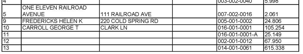
108 Naugatuck Beacon Falls Final Regional Overview Report 105

109 106 Final Regional Overview Report Figure 38: Land Parcel Inventory Map 1 for Thomaston
110 Figure 39: Land Parcel Inventory Map 2 for Thomaston Final Regional Overview Report 107
111 108 Final Regional Overview Report Figure 40: Land Parcel Inventory Map 3 for Thomaston/Watertown

112 Figure 41: Land Parcel Inventory Map 4 for Thomaston/Watertown Final Regional Overview Report 109
113 110 Final Regional Overview Report Figure 42: Land Parcel Inventory Map 5 for Naugatuck
114 Figure 43: Land Parcel Inventory Map 6 for Naugatuck/Beacon Falls Final Regional Overview Report 111

115 112 Final Regional Overview Report Figure 44: Land Parcel Inventory Map 7 for Naugatuck/Beacon Falls

116 Figure 45: Land Parcel Inventory Map 8 for Beacon Falls Final Regional Overview Report 113
117 This page intentionally blank 114 Final Regional Overview Report
118 Appendix C Detailed Cost Estimate Tables Regional Naugatuck River Greenway Routing Study Preliminary estimates of construction costs based upon the recommended greenway sections are described in this appendix. Important assumptions used to arrive at these estimates include: All costs are in 2010 dollars (no adjustments for inflation) Costs do not include property acquisition Peripheral roadway intersection improvements are not included (e.g. replacing a poorly functioning intersection with a round-about) Standard construction methods and materials are used These estimates were prepared using the latest revisions to the CTDOT s Preliminary Cost Estimating Guidelines, dated January In keeping with CTDOT s cost estimating guidelines, the costs include a number of miscellaneous items that are based on a percentage of construction costs (e.g., maintenance and protection of traffic [4%], minor items [25%] and incidentals [21%]). These percentages tend to be conservative estimates of actual cost. Cost estimates can also be impacted when a local public works department carries out the work. In these cases, some of CTDOT s estimated add-ons would not apply. Where appropriate, adjustments to the typical unit prices were made to reflect current market conditions and the consultant team s experience with other greenway construction projects. The guidelines were supplemented where necessary for atypical items (e.g., pre-fabricated pedestrian bridges, boat launches, etc.). Final Regional Overview Report 115


119 Appendix C1 Thomaston Detailed Cost Estimate Tables 116 Final Regional Overview Report

120 Figure 46: Thomaston Trail Segment Cost Estimate Location Diagram. Final Regional Overview Report 117
121 118 Final Regional Overview Report
122 Final Regional Overview Report 119
123 120 Final Regional Overview Report
124 Final Regional Overview Report 121
125 122 Final Regional Overview Report
126 Final Regional Overview Report 123
127 124 Final Regional Overview Report
128 Final Regional Overview Report 125
129 126 Final Regional Overview Report
130 Final Regional Overview Report 127
131 128 Final Regional Overview Report
132 Final Regional Overview Report 129
133 130 Final Regional Overview Report
134 Final Regional Overview Report 131
135 132 Final Regional Overview Report
136 Final Regional Overview Report 133
137 134 Final Regional Overview Report
138 Final Regional Overview Report 135
139 136 Final Regional Overview Report
140 Final Regional Overview Report 137
141 138 Final Regional Overview Report
142 Final Regional Overview Report 139


143 Appendix C2 Watertown Detailed Cost Estimate Tables 140 Final Regional Overview Report

144 Figure 47: Watertown Trail Segment Cost Estimate Location Diagram. 141 Final Regional Overview Report
145 142 Final Regional Overview Report
146 Final Regional Overview Report 143
147 144 Final Regional Overview Report
148 Final Regional Overview Report 145
149 146 Final Regional Overview Report
150 Final Regional Overview Report 147
151 148 Final Regional Overview Report
152 Final Regional Overview Report 149
153 150 Final Regional Overview Report
154 Final Regional Overview Report 151
155 152 Final Regional Overview Report
156 Final Regional Overview Report 153
157 154 Final Regional Overview Report
158 Final Regional Overview Report 155
159 156 Final Regional Overview Report
160 Final Regional Overview Report 157
161 158 Final Regional Overview Report
162 Final Regional Overview Report 159
163 160 Final Regional Overview Report
164 Final Regional Overview Report 161
165 162 Final Regional Overview Report
166 Final Regional Overview Report 163
167 164 Final Regional Overview Report
168 Final Regional Overview Report 165
169 166 Final Regional Overview Report
170 This page intentionally blank Final Regional Overview Report 167


171 Appendix C3 Naugatuck Detailed Cost Estimate Tables 168 Final Regional Overview Report

172 Figure 48: Naugatuck Trail Segment Cost Estimate Location Diagram. Final Regional Overview Report 169
173 170 Final Regional Overview Report
174 Final Regional Overview Report 171
175 172 Final Regional Overview Report
176 Final Regional Overview Report 173
177 174 Final Regional Overview Report
178 Final Regional Overview Report 175
179 176 Final Regional Overview Report
180 Final Regional Overview Report 177
181 178 Final Regional Overview Report
182 Final Regional Overview Report 179
183 180 Final Regional Overview Report
184 Final Regional Overview Report 181
185 182 Final Regional Overview Report
186 Final Regional Overview Report 183

187 184 Final Regional Overview Report
188 Final Regional Overview Report 185
189 186 Final Regional Overview Report
190 Final Regional Overview Report 187
191 188 Final Regional Overview Report
192 Final Regional Overview Report 189
193 190 Final Regional Overview Report
194 Final Regional Overview Report 191
195 192 Final Regional Overview Report
196 This page intentionally blank Final Regional Overview Report 193


197 Appendix C4 Beacon Falls Detailed Cost Estimate Tables 194 Final Regional Overview Report

198 Figure 49: Beacon Falls Trail Segment Cost Estimate Location Diagram. Final Regional Overview Report 195
199 196 Final Regional Overview Report
200 Final Regional Overview Report 197
201 198 Final Regional Overview Report
202 Final Regional Overview Report 199
203 200 Final Regional Overview Report
204 Final Regional Overview Report 201
205 202 Final Regional Overview Report
206 Final Regional Overview Report 203
207 204 Final Regional Overview Report
208 Final Regional Overview Report 205
209 206 Final Regional Overview Report
210 Final Regional Overview Report 207
211 208 Final Regional Overview Report
212 Final Regional Overview Report 209
213 210 Final Regional Overview Report
214 Final Regional Overview Report 211
215 212 Final Regional Overview Report
216 Final Regional Overview Report 213
217 214 Final Regional Overview Report
218 Final Regional Overview Report 215
219 216 Final Regional Overview Report
220 Final Regional Overview Report 217
221 218 Final Regional Overview Report
222 Final Regional Overview Report 219
223 220 Final Regional Overview Report
224 Final Regional Overview Report 221
225 222 Final Regional Overview Report
226 Final Regional Overview Report 223
227 224 Final Regional Overview Report
228 Final Regional Overview Report 225
229 This page intentionally blank 226 Final Regional Overview Report
230


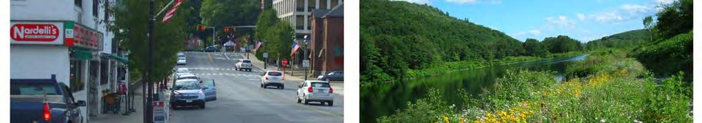


231
232

233
FEASIBILITY CRITERIA
 This chapter describes the methodology and criteria used to evaluate the feasibility of developing trails throughout the study areas. Land availability, habitat sensitivity, roadway crossings and on-street
AGENDA ITEM 5 D WAKULLA ENVIRONMENTAL INSTITUTE (WEI) TRAIL FEASIBILITY STUDY
 TRAIL FEASIBILITY STUDY") March 19, 2018 AGENDA ITEM 5 D WAKULLA ENVIRONMENTAL INSTITUTE (WEI) TRAIL FEASIBILITY STUDY TYPE OF ITEM: Action STATEMENT OF ISSUE The Wakulla Environmental Institute (WEI) Trail is one of several trails
March 19, 2018 AGENDA ITEM 5 D WAKULLA ENVIRONMENTAL INSTITUTE (WEI) TRAIL FEASIBILITY STUDY TYPE OF ITEM: Action STATEMENT OF ISSUE The Wakulla Environmental Institute (WEI) Trail is one of several trails
Naugatuck River Greenway Steering Committee
 This letter is being submitted in strong support of the City of Ansonia s application to the Department of Energy and Environmental Protection Recreational Trails Program for the funding to conduct a routing
Blueways: Rivers, lakes, or streams with public access for recreation that includes fishing, nature observation, and opportunities for boating.
 Parks, Open Space and Trails PRINCE WILLIAM COUNTY 2008 COMPREHENSIVE PLAN TRAILS PLAN CONTENTS The components of the trails plan are: Intent Definitions Goals, Policies, and Action Strategies Trails Map
At the time, the portion of the line through Eagle County remains wholly under the ownership of Union Pacific Railroad (UP).
.") Chapter 5 The Railroad Corridor as a Trail Corridor The intent of this chapter is to identify how the rail corridor, if available for lease or purchase in all or part, could be incorporated into the core
Chapter 5 The Railroad Corridor as a Trail Corridor The intent of this chapter is to identify how the rail corridor, if available for lease or purchase in all or part, could be incorporated into the core
4. Safety Concerns Potential Short and Medium-Term Improvements
 NH Route 104 Access Management Study Page 19 4. Safety Concerns Potential Short and Medium-Term Improvements Potential safety improvement strategies are listed by priority based on field observations by
Longmont to Boulder Regional Trail Jay Road Connection DRAFT FINAL REPORT
 Longmont to Boulder Regional Trail Jay Road Connection DRAFT FINAL REPORT December 2018 Project Summary Boulder County, Colorado, in partnership with the City of Boulder, is evaluating options for multi-use
CHAPTER III: TRAIL DESIGN STANDARDS, SPECIFICATIONS & PERMITS
 CHAPTER III Trail Design Standards, Specifications & Permits This chapter discusses trail standards, preferred surface types for different activities, permits, and other requirements one must consider
City of Durango 5.8 FUNDING TRAILS DEVELOPMENT
 5.8 FUNDING TRAILS DEVELOPMENT The City has been successful in establishing dedicated local funding sources as well as applying for grants to develop the City s trail system, having received nearly $2.4
Georgetown-Lewes Rail/Trail Study. Rail/Trail Study: Cool Spring to Cape Henlopen State Park New Road Extension (House Resolution No.
 Georgetown-Lewes Rail/Trail Study Rail/Trail Study: Cool Spring to Cape Henlopen State Park New Road Extension (House Resolution No. 47) August 22, 2011 Presentation Outline Background Benefits Statewide
3. COLTA / HUGA CONNECTIONS - PRELIMINARY
 9 3. COLTA / HUGA CONNECTIONS - PRELIMINARY 3.1 COLTA The Chain of Lakes Trail Association (COLTA) trail, formerly identified as the Chester Spur Line, was completed and opened for use in June 2011. The
Blue River Trail Master Plan JSA to Town Hall June 2004
 Blue River Trail Master Plan JSA to Town Hall June 2004 Prepared for: Silverthorne Town Council Silverthorne SPORT Committee Department of Recreation and Culture Silverthorne Public Works Silverthorne
A CASE FOR COMPLETING THE JORDAN RIVER PARKWAY: A
 A CASE FOR COMPLETING THE JORDAN RIVER PARKWAY: A safe crossing at 9000 South and 850 West Proposed 9000 South Underpass Parkway Timeline Parkway, Trail, and Tourism Facts Blueprint Jordan River 1971 1973
chapter - Hex Highway Touring Route Hamburg to Strausstown Overview
 chapter - 2 Hex Highway Touring Route Hamburg to Strausstown Overview The on-road Hex Highway automobile and bicycle touring route begins on State Street in downtown Hamburg. The route continues west on
2. Goals and Policies. The following are the adopted Parks and Trails Goals for Stillwater Township:
 D. PARKS AND TRAILS 1. Introduction Stillwater Township s population is relatively low, with most residents living on rural residences on large lots. The need for active park space has been minimal in
The Baker/Carver Regional Trail is intended to
 Section V Design Guidance The Baker/Carver Regional Trail is intended to safely accommodate 183,000 annual visits, an array of non-motorized uses, a variety of skill levels, and persons with special needs.
NEWBORO AND PORTLAND HARBOUR REDVELOPMENT PLANS
 INTRODUCTION The Municipal docks in both Newboro and Portland were transferred to the Township of Rideau Lakes by Parks Canada in 2002. Little has been done to improve the docks physical condition or role
Trail Feasibility Study
 VOLUSIA COUNTY MPO CITY OF NEW SMYRNA BEACH FINAL REPORT JUNE 30, 2009 Trail Feasibility Study What s inside? 1 Introduction 2 Project Purpose & Scope 3 Physical Inventory & Assessment of Right-of- Way
Understanding user expectations And planning for long term sustainability 1
 Understanding user expectations And planning for long term sustainability 1 What is a natural surface trail? It can be as simple has a mineral soil, mulched or graveled pathway, or as developed as elevated
DRAFT - APRIL 13, 2007 ROUTING STUDY FOR TRAIL CONNECTIONS BETWEEN CALAIS AND AYERS JUNCTION
 DRAFT - APRIL 13, 2007 ROUTING STUDY FOR TRAIL CONNECTIONS BETWEEN CALAIS AND AYERS JUNCTION Abstract The vision for the East Coast Greenway is an off-road urban trail system running from Calais, Maine
Business Item No
 Metropolitan Parks and Open Space Commission Meeting date: February 6, 2018 For the Community Development Committee meeting of February 20, 2018 For the Metropolitan Council meeting of February 28, 2018
Macleod Trail Corridor Study. Welcome. Macleod Trail Corridor Study Open House. Presentation of Proposed Design Concepts
 Macleod Trail Corridor Study Welcome Macleod Trail Corridor Study Open House Presentation of Proposed Design Concepts Study Purpose Develop a corridor plan for Macleod Trail that aligns with The City s:
Non-Motorized Transportation
 Non-Motorized Transportation Non-motorized facilities are important components to the transportation system. They provide an environmentally-friendly, low-cost mode of travel. Some of the facilities can
MORGAN CREEK GREENWAY Final Report APPENDICES
 APPENDICES MORGAN CREEK GREENWAY Appendix A Photos of Existing Conditions in Trail Corridor Photos of existing conditions Main trail corridor - February 2009 Photos of existing conditions south bank Morgan
APPENDIX OFFICIAL MAP ORDINANCE OF HAMILTONBAN TOWNSHIP OFFICIAL MAP NARRATIVE
 APPENDIX A OFFICIAL MAP ORDINANCE OF HAMILTONBAN TOWNSHIP OFFICIAL MAP NARRATIVE INTRODUCTION: The Official Map of Hamiltonban Township has been prepared to identify those lands and features that Hamiltonban
Regional Wayfinding Sign Strategy Thurston County Trails 2017
 Regional Wayfinding Sign Strategy Thurston County Trails 2017 Partners: Members and partnering organizations of the Thurston Thrives Community Design Action Team City of Lacey, City of Olympia, City of
Gardner: overview. Santa Fe, Oregon, and California National Historic Trails UNINCORPORATED JOHNSON COUNTY OLATHE UNINCORPORATED JOHNSON COUNTY
 Santa Fe, Oregon, and California ational Historic Trails : overview 99: p.134 100: p.135 GARDER JUCTIO 102: p.137 56: p.126 EDGERTO Burlington orthern Intermodal and Logistics 98: p.133 101: p.136 S Waverly
Auburn Trail / Ontario Pathways Trail Connector Feasibility Study Public Information Meeting Wednesday, August 22, 2012
 Auburn Trail / Ontario Pathways Trail Connector Feasibility Study Public Information Meeting Wednesday, August 22, 2012 Purpose of Feasibility Study Purpose Evaluate the feasibility of constructing a multiuse
2016 Regional Transportation Alternatives Program (TAP) Grant Application
 Grant Application") 2016 Regional Transportation Alternatives Program (TAP) Grant Application PROJECT TITLE: Yelm-Tenino Trail Extension Feasibility Study TRPC use only GENERAL PROJECT INFORMATION Agency or Organization City
2016 Regional Transportation Alternatives Program (TAP) Grant Application PROJECT TITLE: Yelm-Tenino Trail Extension Feasibility Study TRPC use only GENERAL PROJECT INFORMATION Agency or Organization City
ROAD AND TRAIL PROJECT APPROVAL
 ROAD AND TRAIL PROJECT APPROVAL www.marincountyparks.org Marin County Parks, 3501 Civic Center Dr, Suite 260, San Rafael, CA 94903 DATE: July 12, 2017 PRESERVE: Gary Giacomini Open Space Preserve PROJECT:
Other Principle Arterials Minor Arterial Major Collector Minor Collector Local
 CHAPTER 10 TRANSPORTATION Introduction The system of public roads in East Pikeland Township is decidedly rural in character. Since the 1984, the road network has remained much the same, with the addition
University Region Non-Motorized Plan 2015
 Non-Motorized Transportation Non-motorized facilities are important components to the transportation system. They provide an environmentally-friendly, low-cost mode of travel. Some of the facilities can
URBAN DESIGN REPORT. Proposed Residential Development, Old Church Road, Caledon East
 Proposed Residential Development, Old Church Road, Caledon East TABLE CONTENTS: 1.0 DEVELOPMENT 1.1 Introduction-Analysis of Guiding Principles and Documents 1.2 Community Design and Architectural Design
Segment 2: La Crescent to Miller s Corner
 goal of the USFWS refuges is to conserve, protect and enhance fish, wildlife and plants and their habitats for the continuing benefit of the American people. Refuge lands are used largely for fishing,
Section II. Planning & Public Process Planning for the Baker/Carver Regional Trail began in 2010 as a City of Minnetrista initiative.
 Section II Planning & Public Process Planning for the began in 2010 as a City of initiative. city staff began discussions with the Park District on the possibility of a north/south regional trail connection
C. APPROACH FOR IDENTIFYING THE BEST ROUTES FOR THE NEEDED TRANSMISSION SYSTEM IMPROVEMENTS
 C. APPROACH FOR IDENTIFYING THE BEST ROUTES FOR THE NEEDED TRANSMISSION SYSTEM IMPROVEMENTS CL&P s approach for identifying the best routes for the needed transmission system improvements included a determination
Chapter 6: POLICY AND PROCEDURE RECOMMENDATIONS
 Chapter 6 POLICY AND PROCEDURE RECOMMENDATIONS FOR SRRA Below are seven policy elements that should be considered for adoption by the Southwest Regional Recreation Authority of Virginia: 1. Develop strategies
A. CONCLUSIONS OF THE FGEIS
 Chapter 11: Traffic and Parking A. CONCLUSIONS OF THE FGEIS The FGEIS found that the Approved Plan will generate a substantial volume of vehicular and pedestrian activity, including an estimated 1,300
Little River Trail Feasibility Study
 Final April, 2014 Prepared for the State Coastal Conservancy By the Natural Resources Services Division of Redwood Community Action Agency Table of Contents Executive Summary... 1 1. Project Purpose and
Chapter 4.0 Alternatives Analysis
 Chapter 4.0 Alternatives Analysis Chapter 1 accumulated the baseline of existing airport data, Chapter 2 presented the outlook for the future in terms of operational activity, Chapter 3 defined the facilities
Port Gamble Shoreline Area Conceptual Trail Proposal
 The North Kitsap Trails Association is pleased to be a partner to the Kitsap Forest and Bay Project and assist Kitsap County, Forterra, Olympic Property Group, Great Peninsula Conservancy and the Port
Logo Department Name Agency Organization Organization Address Information 5700 North Sabino Canyon Road
 Logo Department Name Agency Organization Organization Address Information United States Forest Coronado National Forest 5700 North Sabino Canyon Road Department of Service Santa Catalina Ranger District
Appendix 3. Greenway Design Standards. The Whitemarsh Township Greenway Plan
 Appendix 3 Greenway Design Standards This chapter discusses two design standards for the greenway types discussed above. First, trail design standards are presented together with trailhead facilities and
ANCLOTE COASTAL TRAIL ALTERNATIVES ANALYSIS STUDY
 ANCLOTE COASTAL TRAIL ALTERNATIVES ANALYSIS STUDY PASCO COUNTY MPO JULY 2015 PROJECT OVERVIEW... INTRODUCTION EXECUTIVE SUMMARY CONTEXT... TAMPA BAY AREA, PINELLAS, & PASCO COUNTY S MULTI-USE TRAIL PLANS
PURPOSE AND NEED (CONCURRENCE POINT 1) NEW CANADA ROAD PROJECT FROM STATE ROUTE 1 (U.S. HIGHWAY 70) TO U.S. INTERSTATE 40
 NEW CANADA ROAD PROJECT FROM STATE ROUTE 1 (U.S. HIGHWAY 70) TO U.S. INTERSTATE 40") PURPOSE AND NEED (CONCURRENCE POINT 1) NEW CANADA ROAD PROJECT FROM STATE ROUTE 1 (U.S. HIGHWAY 70) TO U.S. INTERSTATE 40 Project Description The primary purpose of this project is to improve the major
PURPOSE AND NEED (CONCURRENCE POINT 1) NEW CANADA ROAD PROJECT FROM STATE ROUTE 1 (U.S. HIGHWAY 70) TO U.S. INTERSTATE 40 Project Description The primary purpose of this project is to improve the major
Lake Erie Commerce Center Traffic Analysis
 LOCATION: East of NYS Route 5 at Bayview Road Town of Hamburg Erie County, New York PREPARED BY: Wendel Companies 140 John James Audubon Parkway Suite 200 Amherst, New York 14228 January 2012 i ii Table
Welcome to the Cross County Trail Public Input Session!
 Welcome to the Cross County Trail Public Input Session! Please sign in on the table below! What are we doing here? Camden County has proposed a bicycle and pedestrian trail spanning across the entire county.
Classifications, Inventory and Level of Service
 Classifications, Inventory and Level of Service Section 3 Kenmore Park, Recreation and Open Space Plan 1 P a g e Classifications and Inventory Park Classifications Kenmore classifies its parks based upon
ALBANY-HUDSON ELECTRIC TRAIL FEASIBILITY STUDY. Final Report OCTOBER 2011
 ALBANY-HUDSON ELECTRIC TRAIL FEASIBILITY STUDY Final Report OCTOBER 2011 ALBANY-HUDSON ELECTRIC TRAIL FEASIBILITY STUDY Prepared for: Town of East Greenbush 225 Columbia Turnpike Rensselaer, New York 12144
I. INTRODUCTION EAST COAST GREENWAY STUDY PURPOSE
 I. INTRODUCTION STUDY PURPOSE The purpose of this study is to determine the engineering feasibility of developing the Eastern Trail. It was initiated at the request of the and funded by the Maine Department
Mohawk Hudson Bike Hike Trail Crossroad Connection Study
 Summary Report - April 21, 2003 Mohawk Hudson Bike Hike Trail Crossroad Connection Study Summary Report Introduction The Capital District Transportation Committee (CDTC), in partnership with Albany County,
Trail # NW Tuesday, June DESIGN. Provide an Review the Provide an. Project Goals: System system. wayfinding
 I. Welcome / Introductions Bethany Creek Trail #2 Segment 3 Neighborhood Meeting #1 Bethany Presbyterian Church 15505 NW Springville Road, Portland, OR 97229 Tuesday, June 26, 2018 @ 6:00PM Meeting Minutes
SOUTH INTERCHANGE AREA
 Santaquin City General Plan 1 Location and Characteristics The South Interchange Area of Santaquin is located west of Interstate 15 and south of 500 South (Figure 1). It includes properties already annexed
Business Item No XXX. Proposed Action That the Metropolitan Council approve the Coon Creek Regional Trail Master Plan.
 Business Item No. 2015-XXX Metropolitan Parks and Open Space Commission Meeting date: July 7, 2015 For the Community Development Committee meeting of July 20, 2015 For the Metropolitan Council meeting
Parkland County Municipal Development Plan Amendment Acheson Industrial Area Structure Plan
 Parkland County Municipal Development Plan Amendment Acheson Industrial Area Structure Plan New Plan Acheson Industrial Area Structure Plan Amendment Parkland County Municipal Development Plan Board Reference
Addendum - Airport Development Alternatives (Chapter 6)
") Bowers Field Addendum - Airport Development Alternatives (Chapter 6) This addendum to the Airport Development Alternatives chapter includes the preferred airside development alternative and the preliminary
Bowers Field Addendum - Airport Development Alternatives (Chapter 6) This addendum to the Airport Development Alternatives chapter includes the preferred airside development alternative and the preliminary
EXECUTIVE SUMMARY FALL Introduction. Findings
 EXECUTIVE SUMMARY FALL 2004 Introduction Trails are one of the most popular and highly desirable recreational resources in communities of all sizes throughout the country. In addition to providing a safe
Committee Report. Community Development Committee For the Metropolitan Council meeting of April 13, Business Item No.
 Committee Report Business Item No. 2016-48 Community Development Committee For the Metropolitan Council meeting of April 13, 2016 Subject: Harriet Island-South St. Paul Regional Trail Master Plan, Saint
EXECUTIVE SUMMARY PROGRAM DEVELOPMENT REPORT PURPOSE EXISTING SETTING EXPANDING PARKLAND
 EXECUTIVE SUMMARY PROGRAM DEVELOPMENT REPORT PURPOSE As the culmination of the first phase of the master planning process, this Program Development Report creates the framework to develop the Calero County
Appendix L Technical Memorandum Aesthetics
 Technical Memorandum Aesthetics 1.0 AESTHETICS This section provides a discussion of the aesthetic resources in the vicinity of ARTIC. Aesthetics pertain to the elements that make a certain view pleasing
Lafourche Parish Government REQUEST FOR QUALIFICATIONS. Landscape Architectural Services
 Lafourche Parish Government REQUEST FOR QUALIFICATIONS Landscape Architectural Services Bayou Lafourche Parish Multi-Use Path Feasibility Study Phase 1 And Bayou Lafourche Parish Multi-Use Path Feasibility
The Recreational Trail along Cushing Park road has been a successful addition to the city
 The Recreational Trail along Cushing Park road has been a successful addition to the city Trails TRAILS, PATHS, ROUTES AND CONNECTORS Citizen input pointed to trails, paths, bike routes, and other non-motorized
Stage 2 ION: Light Rail Transit (LRT) from Kitchener to Cambridge
 from Kitchener to Cambridge") Stage 2 ION: Light Rail Transit (LRT) from Kitchener to Cambridge Public Consultation Centre (PCC) No. 3 Please Sign-in Cambridge City Hall November 21, 2017 2:00 to 8:00pm Preston Memorial Auditorium
Stage 2 ION: Light Rail Transit (LRT) from Kitchener to Cambridge Public Consultation Centre (PCC) No. 3 Please Sign-in Cambridge City Hall November 21, 2017 2:00 to 8:00pm Preston Memorial Auditorium
4.19 Parks, Recreation, and Conservation Lands
 interchange would have on the Reed Paige Clark Homestead located on the north side of Stonehenge Road. Alternative D would also affect Palmer Homestead, E.F. Adams House, and Knapp Brothers Shoe Manufacturing
user s guide to Transportation Improvements in Astoria Planning Efforts outside Astoria for more information, contact:
 The Miles Crossing/ Jeffers Garden transportation plan (underway), will identify needed improvements to the Warrenton Astoria Highway and local street improvements to serve expected growth in the Miles
Rogue River Access and Management Plan Draft Alternatives
 Rogue River Access and Management Plan Draft Alternatives The Rogue River Access and Management Plan was initiated in December, 2011 and is being led by Jackson County Parks (JCP) and Oregon Department
Section 3.6 Recreation
 3.6 RECREATION This section evaluates the potential impacts of the proposed project on recreation within MTRP. The evaluation is based on field observations, a review of maps of MTRP and the MTRP Master
Welcome to the future of Terwillegar Park a Unique Natural Park
 Welcome to the future of Terwillegar Park a Unique Natural Park 1 Introduction The Terwillegar Park Concept Plan study will develop an overall concept plan, management objectives and development guidelines
Railroad Safety Trail
 2.1 INTRODUCTION AND PROJECT SETTING 2.1 Introduction & Project Setting Introduction This study is the result of a directed effort on the part of the City of San Luis Obispo to carry out previously established
CHAPTER 4 -- THE LAND USE PLAN: DESCRIPTIONS AND POLICIES FOR THIRTEEN PLANNING AREAS
 CHAPTER 4 -- THE LAND USE PLAN: DESCRIPTIONS AND POLICIES FOR THIRTEEN PLANNING AREAS NORTH CENTRAL CAC AREA LITTLE VALLEY ROAD TO JUG HANDLE CREEK PLANNING AREA This planning area includes Cleone, Noyo,
Citrus Heights Creek Corridor Trail Project Trail Advisory Group Field Trip #2 September 11, :00 11:00 am Trellis Hall, Citrus Heights
 September 11, 2013 9:00 11:00 am Trellis Hall, Citrus Heights Project Overview The City of Citrus Heights is studying the feasibility of establishing a multi use trail system within the City s 26 miles
Electric System Serving Pierce County Current system and future investments
 Electric System Serving Pierce County Current system and future investments Janet Olsen Project Manager Steve Botts Real Estate / Rights-of-Way April 13, 2011 Presentation overview Information requested
FINAL. Bicycle/Pedestrian Feasibility Study City of DeBary Dirksen Drive Trail. Prepared For: Volusia County MPO
 City of DeBary Dirksen Drive Trail FINAL Prepared By: Reynolds, Smith and Hills, Inc. Prepared For: Volusia County MPO September 2007 Table of Contents INTRODUCTION...1 PROJECT PURPOSE AND SCOPE...2 PHYSICAL
Bloor Street West Rezoning Application for a Temporary Use By-law Final Report
 STAFF REPORT ACTION REQUIRED 3741 3751 Bloor Street West Rezoning Application for a Temporary Use By-law Final Report Date: June 12, 2007 To: From: Wards: Reference Number: Etobicoke York Community Council
Recreation Opportunity Spectrum for River Management v
 Recreation Opportunity Spectrum for Management v. 120803 Introduction The following Recreation Opportunity Spectrum (ROS) characterizations and matrices mirror the presentation in the ROS Primer and Field
Rule Governing the Designation and Establishment of All-Terrain Vehicle Use Trails on State Land
 Rule Governing the Designation and Establishment of All-Terrain Vehicle Use Trails on State Land 1.0 Authority 1.1 This rule is promulgated pursuant to 23 V.S.A. 3506. Section 3506 (b)(4) states that an
Frequently Asked Questions on the Route 29 Solutions Improvements Projects
 Frequently Asked Questions on the Route 29 Solutions Improvements Projects Background What are the Route 29 Solutions improvement projects? These projects include the Route 29/250 Interchange ( Best Buy
MPRB: Southwest LRT Community Advisory Committee Issues and Outcomes by Location Current to: 12 November 2010
 MPRB: Southwest LRT Community Advisory Committee Issues and Outcomes by Location Current to: 12 November 2010 This is a compilation of issues and outcomes identified by the CAC. It is a work in progress,
A number of goals were identified during the initial work on this Big Lake Transportation Plan.
 C. Transportation General Background Information Big Lake s transportation system includes all the roads, paths and facilities that allow the movement of private vehicles, trains and planes, as well as
EAST DON TRAIL ENVIRONMENTAL ASSESSMENT. Community Liaison Committee Meeting #3 July 15, :30 to 8:30 pm Flemingdon Park Library
 EAST DON TRAIL ENVIRONMENTAL ASSESSMENT Community Liaison Committee Meeting #3 July 15, 2013 6:30 to 8:30 pm Flemingdon Park Library Agenda 1. Welcome 2. Housekeeping and Updates a) Housekeeping b) CLC
Assessing Your Trails, Keeping Them Safe and Enjoyable
 Jon Wood, PLA, ASLA Associate Vice President Stewart Bert Lynn, PLA, ASLA, LEED AP Project Manager Mecklenburg County Asset and Facility Management Assessing Your Trails, Keeping Them Safe and Enjoyable
Airport Planning Area
 PLANNING AREA POLICIES l AIRPORT Airport Planning Area LOCATION AND CONTEXT The Airport Planning Area ( Airport area ) is a key part of Boise s economy and transportation network; it features a multi-purpose
THRESHOLD GUIDELINES FOR AVALANCHE SAFETY MEASURES
 BRITISH COLUMBIA MINISTRY OF TRANSPORTATION & INFRASTRUCTURE AVALANCHE & WEATHER PROGRAMS THRESHOLD GUIDELINES FOR AVALANCHE SAFETY MEASURES British Columbia Ministry of Transportation & Infrastructure
VI. ALTERNATIVES TO THE MASTER PLAN C. RENOVATED EAST BUILDING ALTERNATIVE
 VI. ALTERNATIVES TO THE MASTER PLAN C. RENOVATED EAST BUILDING ALTERNATIVE INTRODUCTION The Renovated East Building Alternative would include the continued use of the renovated West Building and the renovation
Electric System Serving Pierce County Current system and future investments. Janet Olsen Steve Botts
 Electric System Serving Pierce County Current system and future investments Janet Olsen Steve Botts Project Manager Real Estate t / Rights-of-Way April 13, 2011 Presentation overview Information requested
NORTHEAST CARLTON COUNTY BICYCLE ROUTE PLAN
 NORTHEAST CARLTON COUNTY BICYCLE ROUTE PLAN 5/31/2014 and St. Louis River Trail Plan Update Produced by the Arrowhead Regional Development Commission (ARDC) in Partnership with the State Health Improvement
Northeast Quadrant Distinctive Features
 NORTHEAST QUADRANT Northeast Quadrant Distinctive Features LAND USE The Northeast Quadrant includes all the area within the planning area that is east of Interstate 5 and to the north of State Route 44.
Citrus Heights Creek Corridor Trail Project. Trail Advisory Group Meeting #3 July 8, 2013
 Citrus Heights Creek Corridor Trail Project Trail Advisory Group Meeting #3 July 8, 2013 Agenda Introductions Recap: Community Workshop, Survey Findings, and TAG Field Trip Community Concern Discussion:
Preferred Recreation Recommendations Stemilt-Squilchuck Recreation Plan March 2018
 Preferred Recreation Recommendations Stemilt-Squilchuck Recreation Plan March 2018 Below are the recommended recreation ideas and strategies that package together the various recreation concepts compiled
CHAPTER ONE LITERATURE REVIEW
 CHAPTER ONE LITERATURE REVIEW LITERATURE REVIEW This chapter summarizes the most recently published community impact studies and articles that relate to multiuse trails. The review focuses on publications
Chapter 6. Trail Design. Trail Design
 Chapter 6 Trail Design Trail Design The trail winds through a region rich in scenic beauty, cultural, and natural history. Volunteer landscape architects working with the Core and Planning Teams, have
Thank you for the opportunity to comment on the proposed action to add trails and trailheads to the Red Rock District trail system.
 July 14, 2010 Jennifer Burns Red Rock Ranger District PO Box 20429 Sedona, AZ 86341 Flagstaff Biking Organization PO Box 23851 Flagstaff, AZ 86002 Dear Jennifer- Thank you for the opportunity to comment
SUMMER VILLAGE OF SILVER SANDS. Municipal Development Plan
 SUMMER VILLAGE OF SILVER SANDS Municipal Development Plan Bylaw 253-2014 Adopted August 22, 2014 Summer Village of Silver Sands Municipal Development Plan Bylaw No. 253-2014 Page 2 1 INTRODUCTION 1.1 SETTING
Coast to Coast Connector Summit
 Project Partners Welcome to the Coast to Coast Connector Summit Winter Garden, Florida City Hall October 1, 2014 1 Why are we here? Objectives 1. Inform key stakeholders on the current state of the C2C
FHWA P/N Guidelines. Corridor Relationship. Highway 22 Segment 1 - US 169 to CSAH 2 Relevance / Documentation of Need
 Highway 22 Segment 1 - US 169 to CSAH 2 Vehicle Mobility Congestion Intersection Congestion Existing Conditions - Based on Highway Capacity Manual methodology, corridor level of service is currently LOS
Committee Report. Community Development Committee For the Metropolitan Council meeting of August 12, Business Item No.
 Committee Report Business Item No. 2015-168 Community Development Committee For the Metropolitan Council meeting of August 12, 2015 Subject: Coon Creek Regional Trail Master Plan, Anoka County Proposed
BRACEVILLE NATURE PRESERVE Introductions History Present Conditions Future Development Plans Implementation Strategies Statistics
 BRACEVILLE NATURE PRESERVE Introductions History Present Conditions Future Development Plans Implementation Strategies Statistics Introduction Braceville Nature Preserve is one of MetroParks largest preserves.
Public Notice ISSUED: December 10, 2018 EXPIRES: January 9, 2019
 APPLICANT: REFER TO: St. Louis and Lake Counties Regional Rail Authority 2018-01942-ARC Public Notice ISSUED: December 10, 2018 EXPIRES: January 9, 2019 SECTION:404 - Clean Water Act 1. APPLICATION FOR
Flow Stand Up Paddle Board Parkway Plan Analysis
 Regional Parks Department Jeffrey R. Leatherman, Director County of Sacramento Divisions Administration Golf Leisure Services Maintenance Rangers Therapeutic Recreation Services Flow Stand Up Paddle Board
Proposal to Redevelop Lower Kananaskis River-Barrier Lake. Bow Valley Provincial Park. Frequently Asked Questions
 Proposal to Redevelop Lower Kananaskis River-Barrier Lake Bow Valley Provincial Park Frequently Asked Questions What is being proposed? What are the details of the proposal? Where is the project area located?