Comanche THE TRAIL. Oklahoma and Texas
|
|
|
- Dwayne Patrick
- 5 years ago
- Views:
Transcription

1 Oklahoma and Texas Comanche THE TRAIL
2


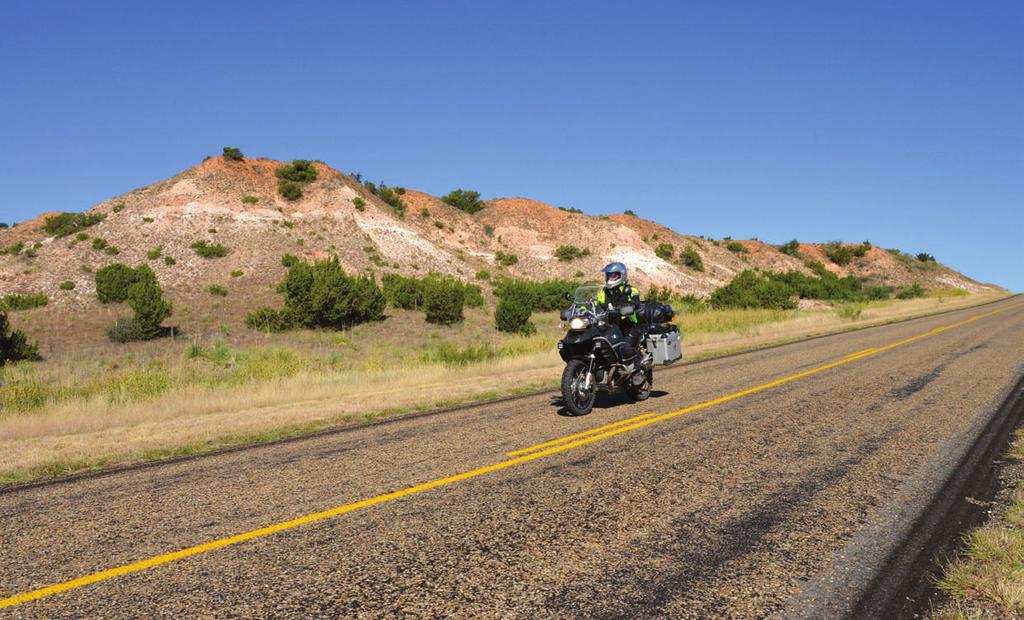
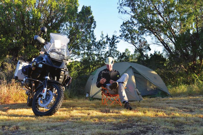
3 TOURS A single dust plume trails behind us like an earthbound jet stream. Narrow leaving the rear tire, it eventually fills our mirrors as I glance back at Susan, riding pillion on our BMW R 1200 GS Adventure. We ve covered hundreds of miles of dirt here in this vast emptiness, seeking the spirits of the Lords of the South Plains in the remote reaches of the Llano Estacado. Text and Photography: Susan and Bill Dragoo They called themselves Numunu, or The People. Their presence is among us as we follow the trail of the Comanche. - Bill Dragoo 60


4 Many of the backroads on this route are groomed and accessible to a wide range of vehicles. This fading sign in Cache, OK, marks the entry to the derelict amusement park where Quanah Parker s Star House is located. We stop and hike to the flat summit of a butte, taking shelter from the stiff south wind in the lee of a stand of cedars, and look west into Texas. Time rewinds 150 years and we are hunters, sentinels of the Antelope Hills. Then, the moving mass of a bison herd would have darkened the horizon, dust obscuring the sky as the animals thundered across the ancient plain. The day when this land was ruled by the Comanches seems close at hand as we look out upon its open prairie and fiery sunsets. In 16, the Comanches were a small tribe of hunter-gatherers living on the northern frontier of New Mexico. They launched an explosive expansion, plundering horses and reinventing themselves as ferocious mounted warriors. Forcing their way onto the southern plains, they carved out a vast territory larger than the entire European-controlled area north of the Rio Grande at the time. Although they successfully forestalled white settlement there for many years, the Comanche empire would ultimately diminish, culminating in surrender at Fort Sill in June Their transition into a new way of life was led by Chief Quanah Parker. Canyons, Creeks, and Grasslands With thunderheads 10 miles high and canyons appearing from nowhere, this is Comancheria, a place of visual infinity centered on the Texas Panhandle and extending into several adjoining states. We are here to experience those canyons, creeks, and grasslands. From our home in Norman, OK, we re heading west to string together a trail through the Comancheria of western Oklahoma and Texas. That trail begins in the Wichita Mountains, an ancient range sculpted through the ages by climatic forces into the knobs and domes of today. The Wichitas offered the tribe hiding places, hunting grounds, and encampment. On their eastern edge, within Fort Sill, jut the Medicine Bluffs, a site sacred to the Comanches and an appropriate starting point for our journey. We stop in the shade along JULY/AUGUST 16 61

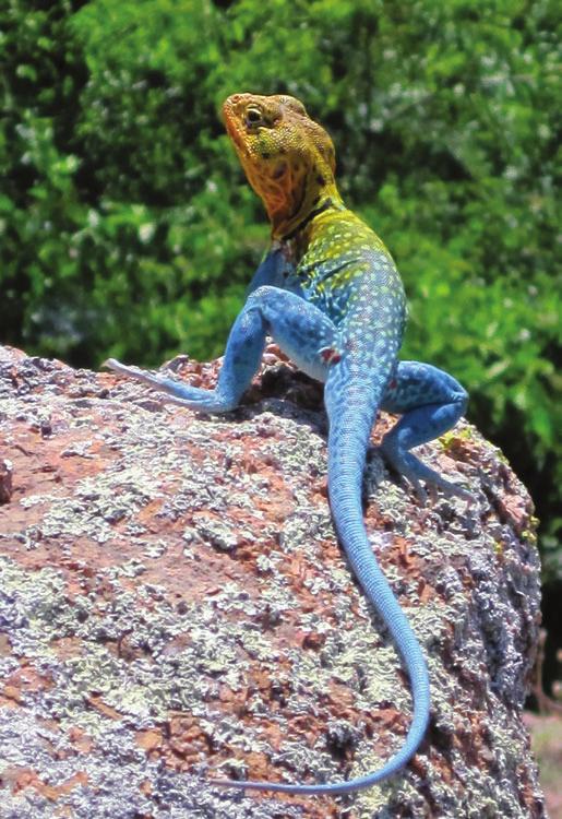
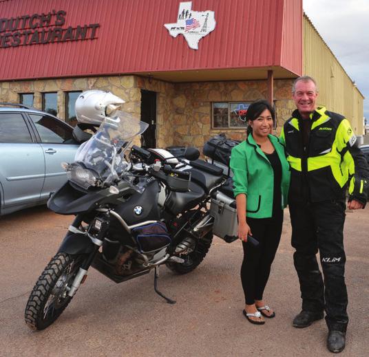
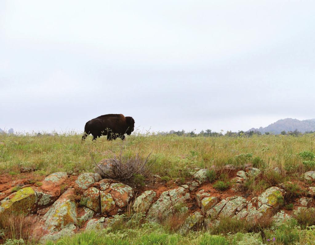
5 Bryce at the long dining room table still present in the deteriorating structure. The Lighthouse formation prominently marks the end of the trail by the same name in Palo Duro Canyon. Bill and Avantika Tamrakar of Kathmandu, Nepal. Tamrakar is one of the owners of Dutch s Restaurant in Quanah, TX. The colorful collared lizard is common to the Wichita Mountains Wildlife Refuge. The scenery is ever-changing along these old asphalt ribbons. the cool, clear waters of Medicine Creek, flowing beneath the 320-foot bluff. Large Comanche encampments once filled this valley full of legends. From Fort Sill we ride west through the Wichita Mountains Wildlife Refuge, where bison and longhorns graze on the open range. The park s roads offer a smooth, twisting ride with mountain views and multiple stopping points for hiking and picnicking. The foot trail to the summit of Elk Mountain is one of the refuge s most popular and yields access to caves and rock rooms perfect for a day of exploring. A motorized ride up the winding road to the top of Mount Scott to watch the sunset over the Oklahoma Plains is a bonus. South of the refuge is the Star House, final home of Quanah Parker. It was built around 1890 for the Comanche leader with the help of Texas cattlemen, and is a testament to the respect he commanded. Quanah was the son of Cynthia Ann Parker, who was captured by Comanches in the 1830s, and Comanche leader Peta Nocona. He balanced his role as leader of his people with his function as an emissary to white culture. Quanah entertained notables as diverse as Geronimo and British Ambassador Lord A tour of the house requires an appointment and a visit to a trading post on a lonesome highway intersection, where we are led into the ghost town of Eagle Park, an abandoned amusement park where the Star House was moved in the mid-20th century. We walk through and photograph the parlor, dining room, and bedrooms on the first floor, but the upper story is inaccessible, and likely dangerous because of the building s poor condition. The roof and walls are sagging, but the building retains a haunting beauty, crouched in the deep green grass canopied by cottonwoods. Crossing the Old Red River Heading west on Highway, we turn south into Texas, crossing the Red River and the state border just north of Quanah, a community established in the 1880s as a railroad stop and named for the Indian chief. We visit the Quanah, Acme and Pacific Railway Depot Museum, built in 1908, before making a side trip on Farm Road 1167 east of town to see the Medicine Mounds, four rounded hills that were camps and ceremonial sites of the Comanches. Our attempt to take a closer look at the mounds leads to a close encounter with some deep, nasty mud. Once we extract the motorcycle, we decide it s best to view the elevations (on private property) from afar. Back in Quanah, we stop for dinner at Dutch s Restaurant. The curator of the local museum had mentioned the cafe is owned by someone from Nepal, and that is what draws us there, having recently visited that region of the Himalayas. When we meet the owner, it s almost like a reunion as we reminisce about our experiences in her homeland. We find a strange irony in our interactions with one another; she, a foreigner in west Texas, welcoming us, virtually natives, and our common bond is a place halfway around the world. Not so long ago the white man was the foreigner here and the Comanches were not quite so welcoming.
6 TOURS JULY/AUGUST 16 63
7
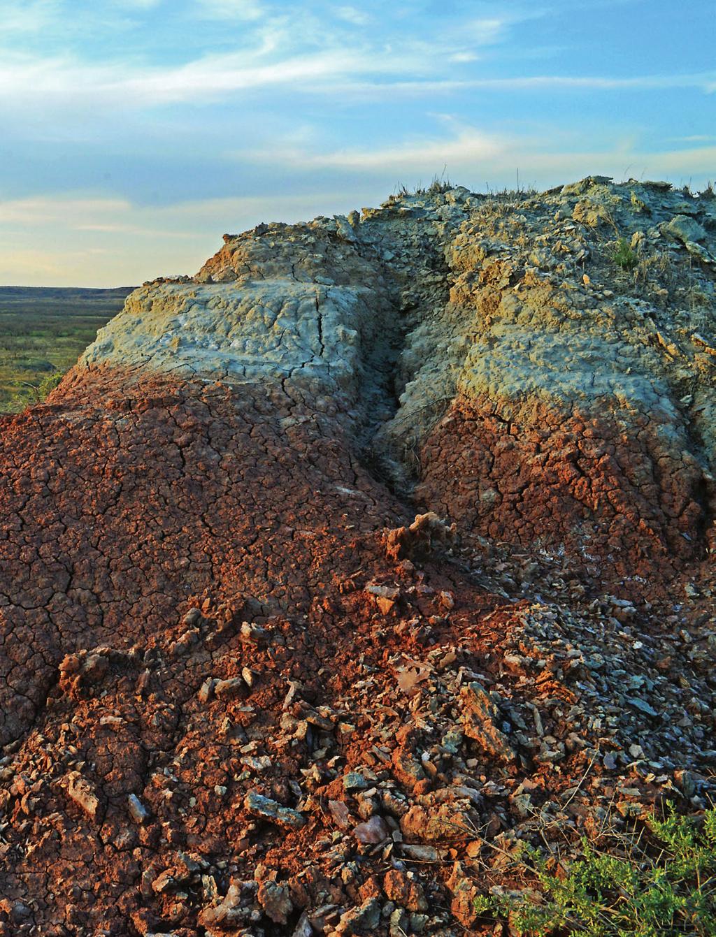
8 TOURS A canyonside campsite in Copper Breaks State Park near Quanah, TX. Bison roam the open range in the Wichita Mountains Wildlife Refuge. Twelve miles south of Quanah is Copper Breaks State Park and our home for the evening. Copper Breaks takes its name from the gray-green streaks of raw copper that band its many rust-colored canyons and arroyos. Near the park is the Pease River Battle Site where Quanah s mother was recaptured from her Comanche band in We camp near one of the breaks in this remote spot notable for its dark skies, perfect for star gazing. We take advantage with an evening walk along the canyon s edge, illuminated by our headlamps, of course. A Desert Oasis in Texas In the morning we continue south and west, looking for a place called Roaring Springs, a lush oasis in the west Texas desert. The site served as a Comanche camp in 1860 and was named for the sound of its rushing waters. Stopping in the town of Roaring Springs for information, we are welcomed by the local coffee club at the Travelers Inn Bed and Breakfast and ultimately escorted by the sheriff to the springs, now within the private Roaring Springs Ranch Club. Locals enjoy the swimming hole created by the springs, which rush from the ground, spilling over a small waterfall into a pool lined with greenery decidedly not what you expect to see in these parts. A highlight of our tour is a large and deeply worn grinding stone on the hillside overlooking the springs. It was used by the Comanches during their encampments. Soon we turn north and west toward Caprock Canyons State Park. During the Comanche reign, New Mexican bison hunters and traders were frequent visitors to this area. The park is home to the Official Bison Herd of the State of Texas and offers hiking and camping in its scenic red canyons. El Llano Estacado Winding dirt roads take us farther northwest through ranch lands and over cattle guards. We now ride atop the Llano Estacado, or Staked Plains, a high mesa sloping toward the southeast and one of the largest tablelands on the continent. Larger than New England, the Llano is bounded on the north by the southern escarpment of the Canadian River valley and on the east by the deeply incised Caprock escarpment. The Llano was first described by Francisco Vázquez de Coronado in a letter to the king of Spain in 1541: I reached some plains so vast, that I did not find their limit anywhere I went, although I traveled over them for more than 300 leagues with no more landmarks than if we had been swallowed up by the sea there was not a stone, nor bit of rising ground, nor a tree, nor a shrub, nor anything to go by. The Other Grand Canyon On the Llano s eastern escarpment just south of Amarillo, Palo Duro Canyon is one of the most spectacular landscapes in Texas. Here we see the intense oranges, reds, and yellows of the Caprock ridge carved into pinnacles, buttes, and mesas by the headwaters of the Prairie Dog Town Fork of the Red River. We camp in Palo Duro and hike early the next morning to the Lighthouse, a 310-foot pedestal rock, before continuing our journey. North of Amarillo is Lake Meredith and the Alibates Flint Quarries National Monument, where Plains Indians dug flint by hand for tools and weapons from 13,000 years ago to about 18. Tools made from Alibates flint have been found in far-flung places across the Great Plains and the Southwest, and National Park Service rangers lead hikes into the ancient quarries. Leaving Alibates we head east on long, dusty roads that sometimes become nothing but ruts along fence lines. Vestiges of abandoned homesteads appear in the form of rock foundations, rusted iron farm implements, and rickety windmills. Battlefields of the Plains Indian Wars We make our way to Adobe Walls, TX, once a trading post near the Canadian River, and the site of two significant battles. The first, in 1864, saw Colonel Christopher Kit Carson leading 335 soldiers and 72 Indian scouts against a force of more than 1,000 Comanches, Kiowas, and Plains Apaches. Ten years later, the Second Battle of Adobe Walls was fought between Comanche forces led by Quanah Parker and medicine man Isa-tai, and a group of 28 U.S. bison hunters who successfully defended the settlement. JULY/AUGUST 16 65


9 TOURS The colorful scenery in Palo Duro Canyon from a perch near the Lighthouse formation is the perfect spot for a photo op. Easy dirt roads can become impassable after a rain. 66


10 The history of this place is rich and the stories fascinating, but all that remains are two granite markers honoring the opposing forces who fought and died here. The River Road takes us on dirt along the Canadian River, crossing the stream on a historic bridge near the town of Canadian, TX. To the east, just inside the Oklahoma border, lie the Antelope Hills. These buttes marked the hundredth meridian and were landmarks for early travelers. They are perhaps best known as the site of an 1858 battle in which Texas Rangers attacked a Comanche village on nearby Little Robe Creek, inflicting a decisive defeat. The Antelope Hills are accessible by vehicle on an unpaved county road. South of the Antelope Hills, we approach the Black Kettle National Grassland, near Cheyenne, OK. Here is the site of the Battle of the Washita, where, in 1868, Lieutenant Colonel George A. Custer led the Seventh U.S. Cavalry on a surprise early morning attack against the Southern Cheyenne village of Peace Chief Black Kettle. Custer was in a hurry to execute the attack and get away because Comanches and Kiowas were also camped in the area and were coming to reinforce the Cheyennes. In Custer s haste he left behind some of his soldiers, who were massacred. It is said that the hatred for Custer harbored by his subordinates over this incident was a major factor in their failure to go to his aid at Little Bighorn. The excellent visitor center at the Washita Battlefield National Historic Site should not be missed. The Grassland also preserves a significant remnant of the mixed-grass prairie so important to the Comanches, providing food for the bison herds. An unpaved road leads us through the area. We stop to explore a ruin of red stone and climb atop a nearby outcropping for a view across the plain, northwesterly toward the Antelope Hills we just left behind. Our last stop is Sandy Sanders Wildlife Management Area, southwest of Sayre. It s another example of pristine prairie and copper breaks. The approach from the north presents a broad valley punctuated with pyramidal formations of red shale and gypsum, best viewed at sunset. The preserve is a stunning contrast to the seemingly featureless landscape seen from Interstate 40, which we eventually use for our three-hour ride home. Comancheria is more than a place. It is an era when fierce men and strong women wove their lives into nature. It was a brief time, really, when the Comanche took their turn as Lords of the South Plains and carved their heritage forever into the pages of history. Today s traveler can still go there and commune with their spirits, in the heart of Comancheria. RR GPS files are available for download in each digital issue purchased or included in your subscription. Log in at Cattle guards and the occasional ranch gate may be encountered on some of the two-track sections of the route. How many generations have come and gone in the abandoned houses found along the trail through Comancheria? JULY/AUGUST 16 67
11 Facts & Information Oklahoma and Texas Total Mileage Approximately 600 miles In General This ride is centered on western Oklahoma and the Texas Panhandle, a mostly rural area best traveled in spring or fall, though mild winters Alibates Flint can also offer pleasant Quarries riding in this region. The tour can be done in three to four days or, for a more leisurely trip, several days more. Factor in side trips to points of interest and distances from your starting point. We recommend approaching it with gazetteers in hand for both Oklahoma and Texas, finding the best dirt roads Dimmitt where possible. How to Get There Starting in Oklahoma s Wichita Mountains, the ride ends at Sandy Sanders Wildlife Management Area near the Texas border. The Wichitas are easily accessed from I-44 in southwestern Oklahoma near Lawton. Airports served by major airlines are also available in Oklahoma City (OKC) and Amarillo, TX (AMA). 15 Lipscomb Arnett 207 A 60 Seiling Morse Brainard Rd 83 Hennessey F O K L A H O M A 8 Pringle 2 81 B Canadian Black Kettle Durham Kingfisher Battle of Adobe Walls 60 Nat l Grassland Roll Watonga 3 Stinnett N1750 Rd E0860 Rd 1913 Fritch Borger Miami N1780 Rd 33 Hammon 33 2 Lake 83 Meredith RM Ew 87.5 E0880 Rd Pampa 30 Clinton Bridgeport El Reno Nat'l Monument Wheeler Sweetwater Oklahoma City 293 Panhandle Elk City New Cordell Binger Sayre Amarillo Shamrock Blanchard 287 Claude 283 Sandy Sanders 6 State Wildlife Anadarko Mgmt Area Hobart 58 8 Chickasha Palo Duro Canyon Clarendon 9 Roosevelt 19 S.P. Wellington Mangum Wichita Meers Mountains Blair 19 Elgin T E X A S 83 Hollis Wildlife Synder 49 Refuge Altus Lawton Eldorado 183 Duncan 5 Caprock Canyons S.P Silverton Frederick Turkey Childress Quanah Comanche 287 Plainview Copper 6 Randlett Breaks S.P. Vernon Matador Floydada Paducah 287 Crowell Roaring Springs Wichita Falls 83 Truscott 27 Ralls Mabelle Dickens Lubbock 207 River Rd Always consult more-detailed maps for touring purposes. Food & Lodging Those looking to camp will have ample opportunity, including Copper Breaks State Park, Caprock Canyons State Park, and Palo Duro Canyon State Park, all in Texas. Plenty of lodging is also available in Lawton, OK, Canyon TX, and Amarillo. Be sure to stop at Meers General Store on the edge of the Wichita Mountains Wildlife Refuge. It s an experience everyone should have at least once, and one of their huge Meers Burgers is big enough for two. Roads & Biking Most roads are secondary pavement or graded dirt and gravel. There are a few instances where unimproved two-track connects the route or leads into more remote regions. A dual-sport motorcycle and some dirt experience are helpful here. Books & Maps El Llano Estacado: Exploration and Imagination on the High Plains of Texas and New Mexico, by John Miller Morris, Texas State Historical Association, ISBN , available new and used online Oklahoma Atlas & Gazetteer, DeLorme, ISBN , available new and used online Texas Atlas & Gazetteer, DeLorme, ISBN , available new and used online Resources AdMo Motorcycle Rentals, Carrollton, TX, Wichita Mountains Wildlife Refuge Washita Battlefield National Historic Site Medicine Mounds, Farm Rd 1167, Medicine Mound, TX, com/history/medicinemounds.htm Texas State Parks, tpwd.texas.gov/ state-parks Black Kettle National Grassland Cheyenne, OK, (580) Sandy Sanders Wildlife Management Area, Erick, OK, Travelers Inn Bed and Breakfast Roaring Springs, TX, (806) Krehbielhaus Wichita Mountains, Roosevelt, OK, rooms/ Motorcycle & Gear: 2011 BMW R 1200 GS Adventure Helmets: Shoei Hornet, Arai XD-4 Jackets: KLIM Badlands Pro, Spidi Venture H2OUT Pants: KLIM Badlands Pro, Spidi Glance Gloves: KLIM Mojave Pro, Tour Master Boots: SIDI Adventure GORE-TEX, BMW Santiago Luggage: Touratech Zega Pro Panniers, Enduristan Typhoon waterproof duffel 68
OKLAHOMA HISTORY OKLAHOMA S GEOGRAPHY
 OKLAHOMA HISTORY OKLAHOMA S GEOGRAPHY BOARD QUESTIONS 1) HOW BIG IS OKLAHOMA? 2) HOW MANY COUNTIES ARE IN OKLAHOMA? 3) HOW FAR IS IT FROM OKC TO LAS ANGLES, CALIFORNIA? 4) HOW MANY STATE BORDER OKLAHOMA?
Flying W Guest Ranch. Oklahoma - Beckham County - Elk City
 Flying W Guest Ranch Oklahoma - Beckham County - Elk City 2 Flying W Guest Ranch is a well-known guest ranch in a historic location about 90 miles west of Oklahoma City near Elk City, Oklahoma. Situated
OKLAHOMA (Route 66 Mother Road s Glory Days)
") OKLAHOMA (Route 66 Mother Road s Glory Days) Little Rock to Fort Smith 159 mi. / 2 hr. 30 min. / I-40 Fort Smith to Oklahoma City - 182 miles / 2 hr. 53 min. / I-40 Oklahoma City to Erick (last city before
OKLAHOMA (Route 66 Mother Road s Glory Days) Little Rock to Fort Smith 159 mi. / 2 hr. 30 min. / I-40 Fort Smith to Oklahoma City - 182 miles / 2 hr. 53 min. / I-40 Oklahoma City to Erick (last city before
Bryce Canyon Country.
 Bryce Canyon Country Backways Itinerary - Grand Staircase, Capitol Reef Region Grand Staircase/Capitol Reef/Henry Mountains Adventure off the beaten path and revel in the beauty of Utah s scenic backways.
Matthiessen State Park Dells Area Hike
 90 Easy Hikes Close to Home At the south end of the hike, you ll climb on top of a mound left over from a former coal-mining operation in the park. Not far from Goose Lake Prairie, the town of Morris hosts
Saturday, June 17 to Sunday June 25, Stampede to Cody
 Saturday, June 17 to Sunday June 25, 2017 Stampede to Cody Wind River Canyon Wind River Canyon is a scenic Wyoming canyon carved out by the Wind River. It is located between the cities of Shoshoni and
ANGEL PEAK SCENIC AREA
 Activities: Facilities: ANGEL PEAK SCENIC AREA Hiking, photography, watchable wildlife, camping, picnicking. Note: While formal hiking trails in the area are limited, dispersed hiking opportunities abound
Sunrise Ranch 6890 acres, Jeff Davis County, Texas On the Fort Davis Scenic Loop
 Sunrise Ranch 6890 acres, Jeff Davis County, Texas On the Fort Davis Scenic Loop 432-386-2821 Cell 432-426-2024 Office james@kinglandwater.com King Land & Water LLC P.O. Box 109, 600 State Street, Fort
BRYCE CANYON COUNTRY Boulder Mountain Scenic backways itinerary
 BRYCE CANYON COUNTRY Boulder Mountain Scenic backways itinerary Boulder Mountain Area The high plateaus of the Aquarius Plateau (Boulder Mountain), are heavily forested and covered in countless winding
Dreamscapes of the American Southwest. Las Vegas to Salt Lake City
 Dreamscapes of the American Southwest Las Vegas to Salt Lake City Day 1: Grand Canyon National Park and Lake Powell Premium Lodging: Lake Powell Resort: Page, AZ Departing from Las Vegas, our journey will
Camp Geronimo Rainbow Trails
 Camp Geronimo Rainbow Trails With over 5,000 acres of surrounding national forest, the possibilities of getting out and seeing the wilderness are almost limitless. Camp Geronimo offers some of the greatest
National Parks Called America s Best Idea
 National Parks Called America s Best Idea Welcome to This Is America in VOA Learning English. I'm Jim Tedder. And I'm Kelly Jean Kelly. This week on our program, we talk about national parks in the United
Dreamscapes of the American Southwest Salt Lake City to Las Vegas
 Dreamscapes of the American Southwest Salt Lake City to Las Vegas Day 1: Arches National Park Premium Lodging: The Sorrel River Resort and Spa: Moab, UT We will depart from Salt Lake City at 10 AM for
FOR SALE. Log Home on 2.27+/- Acres Custer County, South Dakota Offered at $647,000.
 FOR SALE Highlight Features: 5,134 square foot, four bedroom, three and a half bath Cypress Log Home City water and sewer Easy access to endless recreational opportunities Only five minutes to Custer State
Death Valley Is a Beautiful but Dangerous Place
 Death Valley Is a Beautiful but Dangerous Place Welcome to This Is America with VOA Learning English. Today we visit one of America s great national parks. It is a place of strange and silent beauty. As
Kwahadi Museum of the American Indian And Sybil B. Harrington Activity Center Amarillo, TX 2016 Group Lodging and Services Information
 1 Kwahadi Museum of the American Indian And Sybil B. Harrington Activity Center Amarillo, TX 2016 Group Lodging and Services Information Registration Form page 5 Please share with Scouting Friends, Church
A BGES Historic Commemorative Program: Destiny at the Little Big Horn: The 140th Anniversary Study
 A BGES Historic Commemorative Program: Destiny at the Little Big Horn: The 140th Anniversary Study They died with their boots on! For as long as I can remember Custer was that mythical man whose image
Internet TripTik. From : Zion National Park, Ut Stop At Stop At Stop At Stop At Stop At. : Bryce Canyon National Park, Ut : Arches National Park, Ut
 MAP: Overview Internet TripTik From : Zion National Stop At Stop At Stop At Stop At Stop At To : Bryce Canyon National Park, Ut : Arches National : Canyonlands National : Monument Valley, Utah : Kayenta,
Bureau of Land Management Public Lands Guide Northwest District
 Bureau of Land Management Public Lands Guide Northwest District NORTHWEST Fee Site Restrooms Picnic Sites Developed Campgrounds Farmington Field Office (505) 564-7600 Alien Run Mountain Bike Trail Angel
Driving Time: 3 hours (allow extra time for stops)
") Scenic Byways loop This journey takes visitors through the eastern edge of Mt. Rainier National Park and along two of Washington s most beloved scenic byways, the Chinook Byway and the White Pass Scenic
Scenic Byways loop This journey takes visitors through the eastern edge of Mt. Rainier National Park and along two of Washington s most beloved scenic byways, the Chinook Byway and the White Pass Scenic
Spanish Missions History and Purpose
 Spanish Missions History and Purpose Columbus's voyage of discovery opened a new world of possibilities for the Spanish. In the Americas, Spain soon began to use its soldiers to increase the size of its
Photographing Upper Peninsula Waterfalls
 Photographing Upper Peninsula Waterfalls Tod Poirier Freelance Photographer Photography is one of my passions. The following spread showcases several Upper Peninsula waterfalls. At times a single drop
Brinker Creek Ranch. Colorado - Routt County - Yampa
 Located at the base of the Flattops Range in the Steamboat/Vail corridor, Brinker Creek Ranch consists of 1,451 acres ideally suited for high country grazing and native grass hay production. Traditionally
HEADQUARTERS WEST LTD. CATTLE RANCHES HORSE PROPERTIES RURAL REAL ESTATE
 Pastures and Historic Barn Offered for sale exclusively by: Sandy Ruppel Headquarters West, Ltd. PO BOX 542 Sonoita, AZ 85637 Phone (520) 444-1745 sandy@headquarterswest.com www.headquarterswest.com Location
Important Sites to Visit
 Important Sites to Visit Pompey s Pillar Rates & Fees $3.00 per vehicle (Day - until May 1, 2007) $100.00 per bus or group Admission is free with Golden Age, Golden Access, and Golden Eagle Passports.
Climbing Oak and Brushy Top Mountains
 Climbing Oak and Brushy Top Mountains Story and photographs by Vann Helms www.blueridgeimpressions.org Brushy Top Mountain- February 2, 2014 Brushy top summit After a January of record breaking cold weather,
PAUL S PLACE ELK, DEER AND VIEWS FISHTAIL, MONTANA
 McCaslin Land 2010 PAUL S PLACE ELK, DEER AND VIEWS FISHTAIL, MONTANA LOCATION Paul s Place is ideally located in the foothills of the Beartooth Mountains, approximately 5 to 5-1/2 miles west of Fishtail,
Glacier National Park, MT
 Glacier National Park, MT July 28 Aug. 1, 2010 We decided to go to Glacier National Park for our family vacation this year. We had a great time seeing beautiful scenery and a variety of wildlife which
City or County. Enough for State Fair 2018?
 Texas Plains Trail Region PROMOTIONAL AND PARTNER LITERATURE Inventory Updated 1/1/2018 Send info updates to: info@texasplainstrail.com Barbara Brannon 806.747.1997 Ship materials to TPTR, 226 W. Harris
BUCK POINT RANCH. Aspen Associates Realty
 BUCK POINT RANCH Aspen Associates Realty www.aspenassociatesrealty.com 970.544.5800 WELCOME TO Buck Point Ranch is a 960± acre property located in one of the last pristine valleys in close proximity to
University of Oklahoma Libraries Western History Collections. Earl C. Russell Collection
 University of Oklahoma Libraries Western History Collections Earl C. Russell Collection Russell, Earl C. Records, 1939 1953. 4 feet. Collector. Correspondence (1949 1953); membership reports and rosters
Yellowstone & Grand Teton: Walking America s First National Park
 Yellowstone & Grand Teton: Walking America s First National Park Yellowstone & Grand Teton: Walking America s First National Park A massive canyon carved by an ancient volcano plumes of water leaping into
Enough for State Fair 2016?
 Texas Plains Trail Region PROMOTIONAL AND PARTNER LITERATURE Inventory Updated 9/15/16 Send updates to: info@texasplainstr Literature Type Size Qty on Hand Enough for State Fair 2016? City or County Produced
Washakie Wilderness Ranch
 Washakie Wilderness Ranch Dubois, Wyoming Fly Fishing Hunting Ranching Conservation Washakie Wilderness Ranch Dubois, Wyoming Introduction: A stunning 160-acre parcel located at the base of the Ramshorn
Cornucopia Ranch. the
 Cornucopia Ranch the Majestic mountains... Rolling hills... Vast meadows... are all part of the beautiful landscape of the Cornucopia Ranch. Located just 40 miles from Cloudcroft, New Mexico, the Cornucopia
SAN MIGUEL CREEK RANCH. q Trinidad, Las Animas County, Colorado q
 SAN MIGUEL CREEK RANCH q Trinidad, Las Animas County, Colorado q 2 s San Miguel Creek Ranch is a scenic well-balanced cattle and trophy hunting ranch that showcases the very best of Southern Colorado.
Trail Beginning Elevation: 7553 ft The Poison Creek Trailhead is located at the end of National Forest Road 646E (NF-646E).
.") West Mountain Trails Poison Creek Trail #134 Length: 2.9 miles (4.7 km) Difficulty Horseback: A good trail for the first time west mountain rider, some steep sections Hiking: Most Difficult USGS Maps:
West Mountain Trails Poison Creek Trail #134 Length: 2.9 miles (4.7 km) Difficulty Horseback: A good trail for the first time west mountain rider, some steep sections Hiking: Most Difficult USGS Maps:
Best of the Southwest - National Geographic Sweepstakes
 SAMPLE ITINERARY Friday June 15th, 2018 - Friday June 22nd, 2018 Best of the Southwest - National Geographic Sweepstakes Program Meals Friday June 15th Saturday June 16th Sunday June 17th Day 1: Arrive
Subject to sale, withdrawal, or error.
 CANYON DEVELOPMENT PROPERTY RANDALL COUNTY, TEXAS 381.38± ACRES *Drawing For Illustration Only We are pleased to offer the exclusive listing on the. Located in the Texas Panhandle near Canyon and Amarillo,
Fort Ticonderoga Carillon Battlefield Walking Trail Guide
 Fort Ticonderoga Carillon Battlefield Walking Trail Guide Copyright Fort Ticonderoga. Photo Credit Carl Heilman II Length: Approximately 1¾ mile Welcome to Fort Ticonderoga s Walking Trail Blue markers
CLASSIC LODGES AND PARKS OF THE WEST SEPTEMBER 13 23, Escorted by Ms. Christine Friedt
 CLASSIC LODGES AND PARKS OF THE WEST SEPTEMBER 13 23, 2018 Escorted by Ms. Christine Friedt Vacation Highlights: 11 Days / 10 Nights from Rapid City, SD to Salt Lake City, UT Breakfast daily, 1 lunch,
Central Overland Trail Utah & Nevada Driving Guide, First Edition, 2016
 Central Overland Trail Utah & Nevada Driving Guide, First Edition, 2016 Page 51 In the third paragraph, second sentence, change 0.4 miles to 0.1 miles. In the fourth paragraph, second sentence, change
GIFFORD PINCHOT NATIONAL FOREST
 GIFFORD PINCHOT NATIONAL FOREST 9341 Wright Meadow 93 Spencer Meadow Spencer Butte 4247' 30 30A 19 24 80 31C Lewis River Lower Falls 5 Quartz Creek 90 Taidnapam Falls Upper Falls 31 Spencer Peak 3861'
MP : The Big Chief Overlook and the Glen
 MP 253 254: The Big Chief Overlook and the Glen The mile between MP 253 and 254 has lots of history in it. It includes the only recorded remains of the Victory Highway on the Clear Creek County side of
TENNESSEE MOUNTAIN LIVING
 NOVEMBER 2016 Featuring Jasper Highlands TNLand.com END of the YEAR December 26th to Land Sale December 31st See back cover for more info... TENNESSEE MOUNTAIN LIVING JASPER HIGHLANDS - TENNESSEE'S MOST
Crystal Lake Area Trails
 Lake Area Trails Welcome to the Lake area of the Big Snowy Mountains! This island mountain range in central Montana features peaks reaching to 8,600 feet and long, high ridges from which vistas of the
AOTA ArtTrek Locations
 AOTA ArtTrek Locations ArtTrek is a summer-long Grand County, CO art adventure. Highlighted by snow-covered mountain vistas and rolling meadows threaded with sparkling streams and rivers, numerous sites
the Cornucopia Canyon Ranch
 the Cornucopia Canyon Ranch Majestic mountains... Rolling hills... Vast meadows... are all part of the beautiful landscape of the Cornucopia Canyon Ranch. Located just 40 miles from Cloudcroft, New Mexico,
Region: Western High Plains North
 Region: Western High Plains North Note: Attractions marked with an asterisk (*) were recognized as part of the 8 Wonders of Kansas contests, sponsored by the Kansas Sampler Foundation. Don t miss them!
Chapter 7 Geography and the Early Settlement of Egypt, Kush, and Canaan
 Chapter 7 Geography and the Early Settlement of Egypt, Kush, and Canaan How did geography affect early settlement in Egypt, Kush, and Canaan? Section 7.1 - Introduction RF/NASA//Corbis This satellite photograph
U.S. National Forest Campground Guide
 U.S. National Forest Campground Guide Southwestern Region Arizona, New Mexico, Oklahoma and Texas National Forests and Grasslands in the Southwestern Region NF = National Forest NG = National Grassland
Native American Heritage in GRAND CENTRAL USA!
 Native American Heritage in GRAND CENTRAL USA! Day 1 Lawton OK Sulphur OK - Oklahoma City OK We begin our day with a tour of Fort Sill National Historic Landmark & Museum, a 19 th century frontier army
Mt Rushmore, Grand Tetons & Yellowstone 8 Days from $1295
 1 800 422 3727 Mt Rushmore, Grand Tetons & Yellowstone 8 Days from $1295 Itinerary Day 1 Rapid City, South Dakota See some of America s grandest sights Your western adventure begins in Rapid City, South
Adventures in the Rockies. 6 Days
 Adventures in the Rockies 6 Days Adventures in the Rockies On this action-filled adventure, experience two different sides to the Rockies on the western side, discover hidden gems that few visitors get
Eagle Pinon Ranch. 2,963 +/- acres, Hudspeth County
 Eagle Pinon Ranch 2,963 +/- acres, Hudspeth County Eagle Piñon Ranch 2963 acres Hudspeth County, Texas Location The Eagles are part of a chain of sky island mountains that stretch from New Mexico through
4th Grade Third 9 Weeks Test
 4th Grade Third 9 Weeks Test Multiple Choice Identify the choice that best completes the statement or answers the question. 1 A waterway for ships that is dug across land is called a. A port C river B
BRYCE CANYON COUNTRY. A twisted tree endures rugged life on the rim of the Paunsaugunt Plateau.
 BRYCE CANYON COUNTRY Grand Staircase - Paunsaugunt Plateau Scenic backways itinerary A twisted tree endures rugged life on the rim of the Paunsaugunt Plateau. Travel to Bryce Canyon Country. Lodging check-in,
HEADQUARTERS WEST LTD. PHOENIX - TUCSON - SONOITA - COTTONWOOD - ST. JOHNS
 Offered for sale exclusively by: Walter Lane Headquarters West, Ltd. PO BOX 37018 Tucson, AZ 85740 Phone (520) 792-2652 info@headquarterswest.com www.headquarterswest.com General Area Description The Crown
Little Grand Canyon near Pomona, Illinois
 Little Grand Canyon near Pomona, Illinois Below: View of the trail and the terrain created using the Map My Hike app Below: Summary of the hike created using the Map My Hike app Presented by: Jennifer
Spanish Land Grant History of Santa Teresa and Sunland Park Abridged by Dr. Paul Maxwell Taken from the NM Office of the State Historian
 Spanish Land Grant History of Santa Teresa and Sunland Park Abridged by Dr. Paul Maxwell Taken from the NM Office of the State Historian Introduction: Ownership of what now encompasses the Sunland Park
Great Basin Drive, Yosemite to Las Vegas (C18A-3)
") Great Basin Drive, Yosemite to Las Vegas (C18A-3) After finishing up with the California parks, I left Yosemite and entered the Great Basin, which spans a large area east of the Sierra Nevada mountains
Great Basin Drive, Yosemite to Las Vegas (C18A-3) After finishing up with the California parks, I left Yosemite and entered the Great Basin, which spans a large area east of the Sierra Nevada mountains
HUNTING/CATTLE RANCH
 HUNTING/CATTLE RANCH 6,400 DEEDED ACRES IN CATRON COUNTY, NEW MEXICO OFFERED EXCLUSIVELY BY HITCHING POST LAND CO. & SOUTHWEST PROPERTIES, INC. DAVID WOLFSWINKEL, BROKER Office 480-969-8000 Cell 602-377-2368
TOWERBUTTE. Lewis and Clark s. >> By Jerry Penry, LS
 4.95 Lewis and Clark s TOWERBUTTE >> By Jerry Penry, LS Have you ever felt like you are standing on hallowed ground, knowing that some very important surveyors had previously occupied that same location?
Delaware Wildlife Area
 Delaware Wildlife Area 8 miles away from Delaware 4,670 acre Wildlife Area 1) Take Rt. 36/East Williams Street eastward 2) Take left onto Rt. 42/Lake Street 3) Slight left onto Horseshoe Rd./CR. 220 4)
the Webb Ranch Resort
 the Webb Ranch Resort Recreation... Privacy... Comfort... The Webb Ranch Resort is located approximately 6 miles northwest of Pinon, New Mexico. Featuring a beautifully designed, custom log home, the 212
Other Agencies and Organizations
 Daniel Boone National Forest 1700 Bypass Road WInchester, KY 40391 859-745-3100 Location Northern terminus is near Morehead, Kentucky. Southern terminus is located in the Big South Fork NRRA in Tennessee.
Non-motorized Trail Plan & Proposal. August 8, 2014
 Town of Star Valley Ranch, Wyoming and the Star Valley Ranch Association in partnership with the USDA Forest Service, Bridger-Teton National Forest, Greys River Ranger District Non-motorized Trail Plan
THE LOWER L-BAR RANCH
 Wild West Properties, LLC 7400 Gila Road, NE Albuquerque, NM 87109 505-980-8019 http://www.wildwestproperties.com/ Randy J. Wood Qualifying Broker E-mail: rjwood5@comcast.net THE LOWER L-BAR RANCH Widely
Subject to Sale, Withdrawal or Error
 We are proud to offer an exclusive listing on a ranch in a very highly desired part of Northeast New Mexico. This ranch truly expresses the long understood real estate requirements of location, location,
A Publication of Friends of Sleeping Bear Dunes
 A Publication of Friends of Sleeping Bear Dunes 2014, Friends of Sleeping Bear Dunes, P.O. Box 545, Empire, MI 49630 www.friendsofsleepingbear.org info@friendsofsleepingbear.org Learn more about the Friends
Building a Tipi. Essential Questions: Who lived in tipis in Kansas? Why did Indians choose to make their house out of bison hide and wood?
 Building a Tipi Overview: This lesson uses photographs, objects, and a small tipi to introduce students to the tipi as one type of housing used long ago by Indians living on the Kansas plains. Sentence
ADVENTURE. Activities Offerings ADVENTURE
 Activities Offerings ADVENTURE ADVENTURE Situated on 4,200 acres with 5,000 additional acres of private wilderness, Blackberry Farm is its own unique piece of private wilderness, but surrounding the farm
ARCHIVES MONTH in Washington!
 ARCHIVES MONTH in Washington! We received an invitation in September from The State Archives to participate in Archives Month : 2014 is the 125th anniversary of Washington reaching statehood. It is a momentous
Difficult Run Stream Valley Park
 Difficult Run Stream Valley Park The more intense mountain bikers have known about for Difficult Run for some time. Equestrians have known it longer. Eight miles of unpaved trail, the Rails to River Trail
Kwahadi Indian Museum Outpost on the Trail to Mountain Camps! Over 4000 Scouts stayed at the Kiva in 2012! Home of the World Famous Kwahadi Dancers
 2013 Group Summer and Winter Show, Meal, Museum, and Lodging Information Services, prices, and reservation information below. Registration Info pp 4 & 5 Please share with Scouting Friends as needed. 1
Get Your Kicks on Route 66
 Get Your Kicks on Route 66 This week, we go for a ride through the colorful history of Route 66, a road that has been called "The Main Street of America. The idea for Route 66 started in Oklahoma. Citizens
Actions with Indians 1874
 Actions with Indians 1874 4 January 1874 - Wild Rye Creek, Arizona (Lt J B Babcock) B Troop 5th Cavalry 4 Indians killed 8 January 1874 - Pleasant Valley, Arizona (Lt J B Babcock) B Troop 5th Cavalry 2
Region 1 Piney Woods
 Region 1 Piney Woods Piney Woods 1. This ecoregion is found in East Texas. 2. Climate: average annual rainfall of 36 to 50 inches is fairly uniformly distributed throughout the year, and humidity and temperatures
Introduction to Africa
 Introduction to Africa Did you know? Africa has more countries than any other continent. The Sahara is a desert that is the size of the U.S. It s the world's largest desert. Most of the world s gold and
INTRODUCTION 250,000
 INTRODUCTION The United States of America has over 250,000 rivers, with a total of about 3,500,000 miles of rivers. The main stems of 38 rivers in the United States are at least 500 miles (800 km) long.
ETV ENDOWMENT SOUTH DAKOTA GREAT FACES AND GREAT PLACES PATRICK
 SOUTH DAKOTA WITH THE ETV ENDOWMENT AND PATRICK MCMILLAN ETV ENDOWMENT SOUTH DAKOTA with PATRICK McMILLAN Day One: Wednesday-June 7, 2017: Arrivals in Rapid City, South Dakota. Arrive in your gateway city
(Short Listing) DUPUYER ACREAGE, ROCKY MOUNTAN FRONT
 DUPUYER ACREAGE, ROCKY MOUNTAN FRONT") (Short Listing) DUPUYER ACREAGE, ROCKY MOUNTAN FRONT This unique property is located 8½ miles northwest of Dupuyer, Montana and approximately thirty 30 miles northwest of Choteau, Montana. Great Falls
(Short Listing) DUPUYER ACREAGE, ROCKY MOUNTAN FRONT This unique property is located 8½ miles northwest of Dupuyer, Montana and approximately thirty 30 miles northwest of Choteau, Montana. Great Falls
The VERY BEST of ALASKA
 The VERY BEST of ALASKA Cruise/Land Combination: August 1-11, 2018 Beautiful Auke Bay and Mendenhall Glacier in Juneau! This brochure contains information about our Alaska Cruise or Cruise/Tour. There
Bradshaw Trails Series
 Bradshaw Trails Series Curtis James Troop 7014 Curtis.James@erau.edu My Motto: Never get lost! Hiking Rules Bradshaw Hiking Patch Series Hiking Tools Hiking Rules Hiking Merit Badge* Take five 10-mile
BUTCHER CREEK RANCH. Butcher Creek Ranch. Roscoe, Montana. Reduced to $1,650,000.
 BUTCHER CREEK RANCH Butcher Creek Ranch Roscoe, Montana Reduced to $1,650,000. Offered Exclusively By: Sonny Todd Real Estate 301 West First Avenue, PO Box 788 Big Timber, Montana 59011 Office: (406) 932-1031
Discover. Ashhurst Domain. Nature s Playground
 Discover Ashhurst Domain Nature s Playground Discover Step back into New Zealand, Aotearoa, of generations long gone. Discover lush natural surrounds echoing with rich birdsong in one of the Manawatu s
PASTIMES. Newsletter of the Panhandle Archaeology Society February 2016 Volume 36 Number Two. PRESIDENT Scott Brosowske. VICE PRESIDENT Veronica Arias
 PASTIMES PRESIDENT Scott Brosowske Newsletter of the Panhandle Archaeology Society February 2016 Volume 36 Number Two VICE PRESIDENT Veronica Arias SECRETARY Mary Ruthe Carter TREASURER Pam Allison PUBLICATIONS
America s National Parks
 State Farm Employee Activities/Goldtimers presents America s National Parks June 23 July 2, 2012 Join us for an informational meeting! State Farm Beach House November 3, 2011 6:00 pm 10 days 13 Meals:
Grand Canyon, Sedona, Lake Powell, Bryce & Zion 8 Days from $1395
 1 800 422 3727 Grand Canyon, Sedona, Lake Powell, Bryce & Zion 8 Days from $1395 Itinerary Day 1 Phoenix, Arizona See the greatest national parks of America's Southwest! Spend four nights in national park
B HALL RANCH FISHTAIL, MONTANA
 Brochure Courtesy of: B HALL RANCH FISHTAIL, MONTANA w w w. m c c a s l i n l a n d. c o m Page 1 LOCATION The Hall Ranch is ideally located in the foothills of the Beartooth Mountains, approximately 5
President Roosevelt and Naturalist John Burroughs at Fort Yellowstone. Ruined Castles of Yellowstone. East Entrance Station
 President Roosevelt and Naturalist John Burroughs at Fort Yellowstone Ruined Castles of Yellowstone East Entrance Station President Roosevelt at Liberty Cap Yellowstone Lake, Mary s Bay Fire Hole River
Arches of the. Sandflats Area. By Virginia Allen
 Arches of the Sandflats Area By Virginia Allen TABLE OF CONTENTS Introduction Dedication Road Log Arches 1. Perforated View Arch 2. Fee Booth Arch 3. Windsong Arch 4. Weird Arch 5. Resting Arch 6. Bike
Follow our Travels. through
 Follow our Travels through On a regular workday, many people don t get to look forward to a day of travel, tourism, and good food, but here in Freedom s Frontier National Heritage Area (FFNHA), monthly
Children's Discovery Trail Guide - Lost Creek
 Children's Discovery Trail Guide - Lost Creek Thank you for spending time learning and observing some of the secrets of Red Rock Canyon Conservation Area has to offer. Feel free to talk to a ranger if
Southwest Family Adventure. 7 Days
 Southwest Family Adventure 7 Days Southwest Family Adventure See three amazing National Parks Grand Canyon, Bryce, and Zion on this epic camping trip designed with families in mind. Every day offers magnificent
NORTH GEORGIA MOUNTAINS, USA. Pristine Natural Wonder
 NORTH GEORGIA MOUNTAINS, USA Pristine Natural Wonder Pristine Natural Wonder NORTH GEORGIA MOUNTAINS, USA Introduction: This pristine natural wonder is a true geological phenomenon and the Crown Jewel
To Wellness. To Wellness PASSPORT PASSPORT. Partners. Partners. Ashland County Health & Human Services 630 Sanborn Avenue, Ashland, WI
 Partners Ashland County Health & Human Services 630 Sanborn Avenue, Ashland, WI Ashland Bretting Center 320 4th Avenue W., Ashland, WI PASSPORT Bayfield County Health Department 117 E. 6th Street, Washburn,
Bear Butte State Park Trail System NORTH
 Trail System 4426 4250 4000 3750 3500 3250 NORTH SCALE IN FEET 0 1000 2000 Summit Trail Type of trail: Hiking Length of trail: 1.85 miles Trail surface: Dirt and rock Rated: Moderate, somewhat hilly, even
The Battle of Quebec: 1759
 The Battle of Quebec: 1759 In the spring of 1759, the inhabitants of Quebec watched the river with worried eyes. They waited anxiously to see whether the ships of the French, or those of the British fleet,
Expedition: Black Hills
 Medicine Mountain Scout Ranch 24201 Bobcat Road Custer, South Dakota 57730 Expedition: Black Hills Option B1-3 Day Program Destinations Include: Mammoth Site Wind Cave National Park Mount Rushmore 1880