ARCHIVES MONTH in Washington!
|
|
|
- Dustin Taylor
- 5 years ago
- Views:
Transcription
1 ARCHIVES MONTH in Washington! We received an invitation in September from The State Archives to participate in Archives Month : 2014 is the 125th anniversary of Washington reaching statehood. It is a momentous occasion to highlight the documents, artifacts, and photographs that have documented Washington s history and legacy. Construction of the large public works projects such as the Grand Coulee Dam, the North Cascades Highway, and the Tacoma Narrows Bridge are well documented in the collections, but so is apple harvesting, coffee making, politicians and lawmaking, and artists creating public art for all Washingtonians. Please share the items you have come across in your collections that tell an interesting story of MAKING HISTORY over the past 125 years We are asking you to send high-resolution digital copies of historical documents, photographs, or artifacts to Benjamin Helle at the Washington State Archives, benjamin.helle@sos.wa.gov, by Tuesday, September 30th. We plan to make these items part of our special Washington Archives Month online exhibit and Washington Archives Month on Facebook. Planning an Archives Month event? Share that with us, too Knowing that we have many pictures that even local folks have never seen, we chose to highlight five developments from the early days that would feature photographs outside the norm of mining, railroading, logging, etc. The Granite Falls Historical Society would like to contribute some photos for "Archives Month", but as you can imagine, it's difficult to choose from among the thousands we have. Our most popular pictures often involve the long-gone gold mines of Monte Cristo, on the now defunct logging railroads that ran through the woods. To limit our selection, we have chosen to highlight a few extraordinary efforts of past generations to create things that have lasted to the present time. With that constraint, we've chosen to provide several pictures of each of the following: 1) CONSERVATION: the first US Forest Service nursery in the Pacific Northwest, built in Silverton ca 1910, to provide trees for replanting after several huge forest fires. The nursery itself is now gone, but their reclamation results have lasted for generations. 2) ECONOMIC DEVELOPMENT: the construction of Bridge #102 in Snohomish County in 1934, which spans the South Fork of the Stillaguamish River close to the waterfall after which the town of Granite Falls is named. Funded in Feb 1934, the grand opening parade was held only five months later, and the bridge carries hundreds of vehicles per day today, including large numbers of heavy gravel trucks. 3) FOREST MANAGEMENT: the construction of the Verlot Ranger Station in 1938, a beautiful facility that is still in full operation with a great museum for tourists to enjoy. The well-maintained buildings are outstanding examples of architectural details from the period and provide a focal point for tourism and outdoor activities around the Mountain Loop. 4) TOURISM: the construction of the Mountain Loop Highway, taking multiple years, but finally opening in The Civilian Conservation Corps played a major role in creating what is today a significant tourist attraction. The highway provides access to camping, fishing, hiking, and history for 300,000+ people each year. 5) ENVIRONMENTALISM: the construction in of the fish ladder and tunnel allowing spawning salmon for the first time to surmount Granite Falls. It still serves its conservationist role today, and it's a great tourist attraction, as well. With that selection, we hope you enjoy the historic views captured as our predecessors built our community!

.")

2 Silverton Nursery The USFS established a nursery near Silverton, to raise seedlings needed for repairing the ravages of several forest fires. The nursery photos were taken in 1910, and the replanting photos were taken in 1912 at the site of the Buck Creek fire (a few miles east of Silverton). One photo shows Ranger George Sawyer, who was a veteran of the deadly forest fires on the Washington/Idaho border where many lives were lost. The area around the nursery was named "Sawyer" in his honor, and appeared as such on the railroad schedules of the day. Seedling were transported by horse-drawn rail cars to the re-planting headquarters, after which robust manpower was used to replant the steep slopes. C.E. Hinton is shown next to one of the rail cars used.


3 From high on the Buck Creek burn, you can barely make out the railbed of the E&MC far below snaking through the valley at lower right. It was grueling work to replant thousands of seedlings, but the beauty of the region today is in part due to the dedication of these hardy workers.


4 Bridge #102 (The Falls Bridge ) In Feb 1934, funding was approved to build a new bridge across the South Folk of the Stillaguamish River, near Granite Falls. The existing bridge was rated at only 7 tons, far too low a rating to truck heavy logs across the river. Rails from the defunct Everett & Monte Cristo Railway (later owned by the NP, then the Rucker Brothers) were being picked up and sold as scrap, so timber wouldn't be available from the far side - that would be an economic disaster. With added pressure for opening the area to tourism, a new bridge was built and opened in five months! The old bridge was relocated onto a Pilchuck River crossing. The Falls Bridge is a 340 feet long, two-lane structure, with 10-foot wide travel lanes and a sidewalk on each side. It provides access to a vast area with permanent homes, vacation properties, sand and gravel quarries, logging operations, and an unlimited amount of hiking, camping, and other outdoor activities.

5 Eighty years old, the bridge is still sound (although narrower than desired), and is scheduled for replacement in coming years. It took about 5 months and $40,000 to build this bridge in Around 2012, it took fifteen months and $1.08M to repaint just the metalwork! Hopefully, we can find some way to preserve this beautiful span after the replacement bridge is installed (just on the far side of the current bridge in this picture).


6 Verlot Ranger Station Built by the CCC in the late 1930s, the Verlot Ranger Station is maintained by the USFS as a beautiful example of depression-era architecture and construction. It's owned and operated by the US Forest Service and is a major public information center serving the Mountain Loop. The attached pictures were taken in from the same vantage point, to show progress on the complex. The main Ranger Station is the center building, the Ranger residence on the left, and the maintenance shop in the distance on the right. The Verlot Ranger Station is a must stop on the Mountain Loop, since they not only provide vast amounts of useful information in the form of maps and directions, but they also maintain an excellent museum on-site for visitors.


, CCC, and Forest Service uniforms are visible in the picture taken at the opening ceremony at the end of 1941.")
7 Mountain Loop Highway Building a continuous roadway from Granite Falls to Darrington was a decade-long goal, and finally completed in From Granite Falls to Robe, the road had continued to improve over the years, even while the railroad was operating. Once the railroad went out of business, the railroad right-of-way from the Everett & Monte Cristo Railway served as the foundation for much of the roadway between Robe Valley and Barlow Pass. The CCC played a large part in the construction, particularly on the segment from Barlow Pass north to Darrington. Finally, the last bridge (Mowich Bridge), was opened just north of Barlow Pass and the Mountain Loop Highway was a reality! Naval (perhaps Coast Guard), CCC, and Forest Service uniforms are visible in the picture taken at the opening ceremony at the end of The largest CCC camp in the area was in Darrington, although smaller camps existed at times on the South Fork of the Stillaguamish River (Robe Valley).


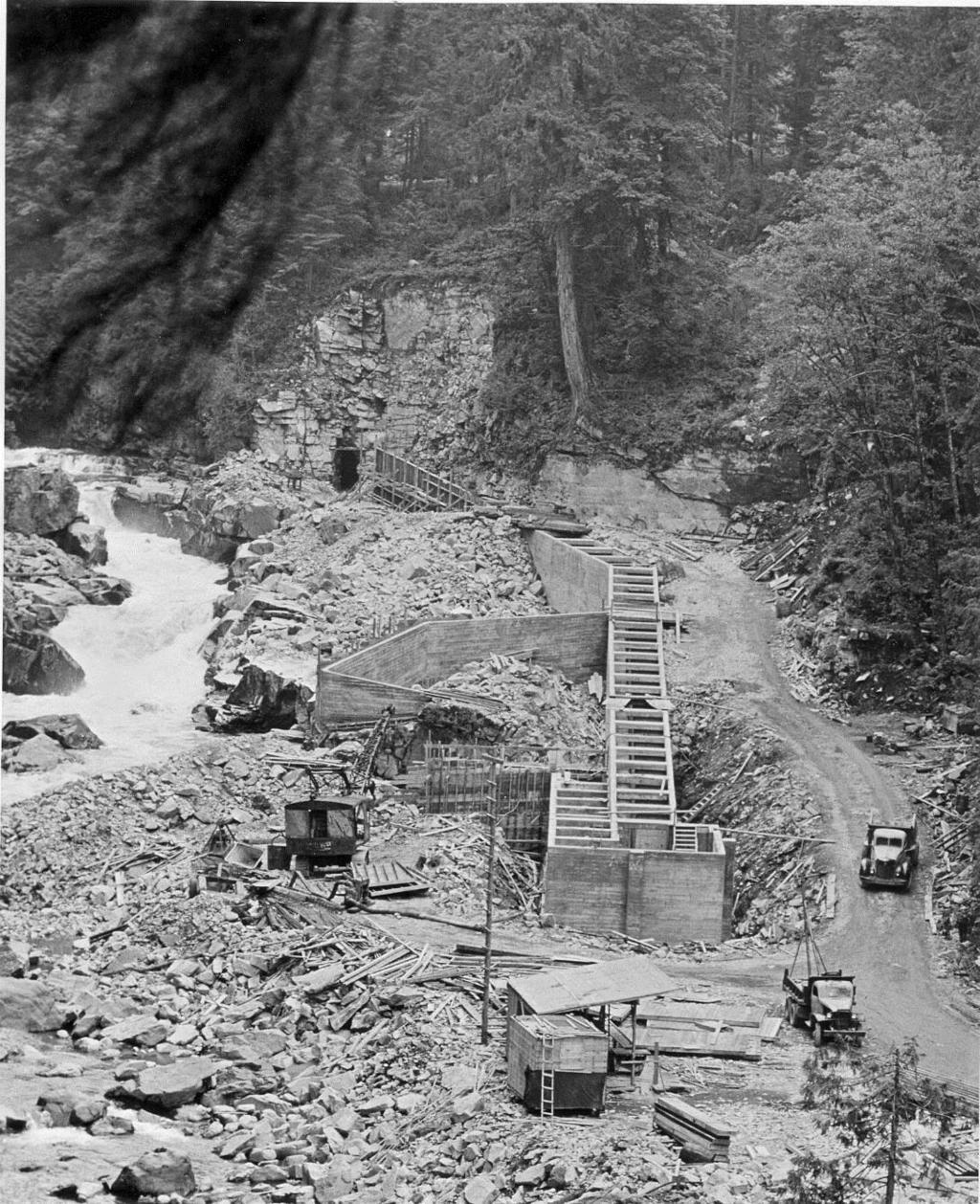
8 Granite Falls Fish Ladder The Granite Falls fish ladder opened in 1954, as the longest of its type in the world. The ladder itself is 580 feet long, and is followed by a 240 footlong tunnel through the granite outcropping. When it was completed, salmon could for the first time reach upstream grounds ideal for spawning. Visitors can now enjoy the falls without scaling the slippery rocks our early residents had to negotiate, now following stairs and concrete ramps. The 1934 Falls bridge is barely visible through the cut in the trees in the background of the construction photo, but is just behind the Granite Falls Fishway sign in the picture showing all the tourist visitors.
9
MCPA Newsletter - March 2014
 MCPA Newsletter - March 2014 www.mcpa.us Board Members President... Kal Klass klasstwin@gmail.com Vice President... Doug Hammond Treasurer... Bill Rawlins Secretary... Ruth Danielson Corresponding Secretary...
Durango. Durango Whitewater Park
 High Adventure Along Colorado s Million Dollar Highway Durango If you re looking for a multi-day trip of Jaw-dropping adventure in the Colorado mountains look no further! This guide outlays 4 days through
Pulaski Tunnel Trail. 15th Annual Carl Anderson Conservation Project Engineering Awards. June 16, 2008
 15th Annual Carl Anderson Conservation Project Engineering Awards U S DEPARTMENT OF AGRICULTURE Pulaski Tunnel Trail June 16, 2008 Project Category C Special Projects - Historical Preservation ENGINEERS
American Conservation Experience
 ACE Project Report For Tonto National Forest, Arizona Trail Association and Arizona State Parks Title of Project: 4 Peaks Trail Maintenance Award Contract Number: ASP NM11021 Project Partner: Paul Burghard
Historic Highway Advisory Committee To Meet in The Dalles
 In This Issue Get Involved Highway Gets Major Endorsement New Life for the Old Road Bike Pods and Hubs Time Travel on the Historic Highway Gorge Ride 2014 The Historic Columbia River Highway News is your
HISTORIC AMERICAN ENGINEERING RECORD COVE CREEK SPILLWAY BRIDGE. HAER No. AR-83
 HISTORIC AMERICAN ENGINEERING RECORD COVE CREEK SPILLWAY BRIDGE LOCATION: Spanning Cove Creek Spillway at State Highway 309 (formerly Paris-Mt. Magazine Road), Corley vicinity, Logan County, Arkansas UTM:
SOL VS.2a, 2b, 2c, 10b
 What are the characteristics of the Coastal Plain? 1. Also known as Tidewater 2. Located near the Atlantic Ocean and the Chesapeake Bay 3. Includes the Eastern Shore, a peninsula between the Atlantic Ocean
Attachment G STREAM IMPACTS. Ridge Road Extension Alternatives Analysis
 Attachment G STREAM IMPACTS for: Ridge Road Extension Alternatives Analysis PREPARED FOR: Pasco County Engineering Services Department PREPARED BY: NV5, INC. 6989 E. FOWLER AVENUE TAMPA, FLORIDA 33617
SPARTA Finding treasures off the beaten path just got a lot easier.
 FIND TREASURES OFF THE BEATEN PATH IN WHITE CO., TN By Amy Davis, Herald Citizen Staff Herald Citizen, Cookeville, TN Thursday, 23 February 2012, pg. A 9 SPARTA Finding treasures off the beaten path just
482 :fi6 D34 --' v.i9 ~
 '- SB 482 :fi6 D34 --' v.i9 ~ This document is made available electronically by the Minnesota Legislative Reference Library as part of an ongoing digital archiving project. http://www.leg.state.mn.us/lrl/lrl.asp
Guide to the L. F. Manis Photographs
 This finding aid was created by Lindsay Oden on February 27, 2018. Persistent URL for this finding aid: http://n2t.net/ark:/62930/f1vk60 2018 The Regents of the University of Nevada. All rights reserved.
Androscoggin River Trail Access Sites. North Woods. 168 miles from its source at Lake Umbagog to Merrymeeting Bay
 Androscoggin River Trail Access Sites North Woods 168 miles from its source at Lake Umbagog to Merrymeeting Bay Trail Under Construction More than 40 Public Access Sites Available Androscoggin River Watershed
RW Bruhn Bridge and Approaches Project
 RW Bruhn Bridge and Approaches Project The Trans-Canada Highway 1 RW Bruhn Bridge and Approaches Project involves four-laning approximately 1.9 km of Highway 1 in Sicamous, including replacement of the
United States Department of the Interior National Park Service. Boundary Expansion Listed in National Register January 11, 2017
 NPS Form 10900-a (Rev. 8/2002) OMB No. 10240018 United States Department of the Interior National Park Service Boundary Expansion Listed in National Register January 11, 2017 National Register of Historic
In Northwest Town, A Local Fight Against Global Coal
 In Northwest Town, A Local Fight Against Global Coal by RICHARD HARRIS October 26, 2011 text size A A A This is the first of two reports on plans to export U.S. coal to China. Plans are afoot to build
Auto-Walking Tour of Osage Hills State Park s Historic Structures
 Auto-Walking Tour of Osage Hills State Park s Historic Structures A guide to some of Osage Hills State Park s distinctive and important historic structures. Introduction President Franklin Roosevelt s
UNITED STATES DEPARTMENT OF THE INTERIOR BUREAU OF RECLAMATION REGION 4 SALT LAKE CITY, UTAH. May 29, 1958
 UNITED STATES DEPARTMENT OF THE INTERIOR BUREAU OF RECLAMATION REGION 4 SALT LAKE CITY, UTAH May 29, 1958 FACT SHEET ON PRIME CONTRACT FOR CONSTRUCTION OF FLAMING GORGE DAM GENERAL INFORMATION Bids will
Guide to the Virginia "Teddy" Fenton Photograph Collection on the Hoover Dam and Boulder City, Nevada
 Guide to the Virginia "Teddy" Fenton Photograph Collection on the Hoover Dam and Boulder City, Nevada This finding aid was created by Lindsay Oden on April 27, 2018. Persistent URL for this finding aid:
WALTON MARSH RAILROAD TIES
 WALTON MARSH RAILROAD TIES A PROJECT SURVEY BY COLIN FRYE Supervisor: Dr. Mark Holley The Walton Marsh Railroad Tie project involved the survey and study of six railroad ties discovered in and on the shoreline
April 10, Mark Stiles San Juan Public Lands Center Manager 15 Burnett Court Durango, CO Dear Mark,
 Mark Stiles San Juan Public Lands Center Manager 15 Burnett Court Durango, CO 81301 Dear Mark, We are pleased to offer the following comments on the draft San Juan Public Lands Center management plans
Segment 2: La Crescent to Miller s Corner
 goal of the USFWS refuges is to conserve, protect and enhance fish, wildlife and plants and their habitats for the continuing benefit of the American people. Refuge lands are used largely for fishing,
Seven mountain peaks you must admire in Washington state
 Seven mountain peaks you must admire in Washington state heraldnet.com /life/seven-mountain-peaks-you-must-admire-in-washington-state/ From a distance, the mountains of the Cascade and the Olympic ranges
Aira Force & Ullswater Access Statement
 Aira Force & Ullswater Access Statement Aira Force, Watermillock, Penrith, CA11 0JS T: 017684 82067 E: ullswater@nationaltrust.org.uk Section 1: Aira Force Section 2: Ullswater Countryside Section 1: Aira
Whiteside Mountain Land Owned by: Location: Trails:
 Whiteside Mountain Latitude: 35 05.123 N Longitude: 083 07.933 W Elevation: 1,503m Land Owned by: US Forest Service Nantahala Ranger District 828-524-6441 Location: Jackson County, NC Turn off of US Highway
Below is the section of the Byway discussed in the Wise/Russell County meeting. Primary coal sites are noted on the map.
 APPENDIX H: PUBLIC PARTICIPATION SERIES OF TOWN MEETINGS Virginia Coal Heritage Trail Corridor Management Plan Meeting in St. Paul on the Wise and Russell County portions of the St. Paul Loop September
Monte Cristo Mining Area CERCLA Removal Action Update
 Monte Cristo Mining Area CERCLA Removal Action Update Bernard Kronschnabel Cascade Earth Sciences October 28, 2014 Background Abandoned gold mine district/ghost town Mining activity 1890s 1900s 1 Project
River to Co. East Boundary Original All Twp 27 between Puget Sound & Snohomish-Snoqualmie Rivers
 DISTRICT NUMBER NAME AND DATE ORIGINATED COMPONENTS HISTORY 1 Snohomish (1868) Original All of Snohomish Co. 300 (1912) - 326 (1929) 327 (1930) 329 (1931) 1 new ((1938) 1 New Snohomish (1938) Consol. #12
Brief Highlights of Mission La Purisima Concepcion
 From the City of Lompoc Web Site Created and Maintained by City of Lompoc Information Services Division A very special thanks to the Lompoc Valley Historical Society and all the good folks for sharing
Guide to the L. F. Manis Photographs
 This finding aid was produced using ArchivesSpace on February 29, 2016. English 2016 The Regents of the University of Nevada. All rights reserved. University of Nevada, Las Vegas. University Libraries.
The Cleo s Bath North Side Hike
 The Cleo s Bath North Side Hike This hike is a cross-country hike from Pinecrest Lake to the north side of Cleo s Bath. It is quieter and much less crowded than the normal route, which goes up the south
Pennsylvania State Parks and the Declining Budget
 Pennsylvania State Parks and the Declining Budget By Andrew Wurst English 202A Section 001 Dr. Tammie Fleeger April 27, 2011 Pennsylvania currently has some of the best state parks and recreation areas
Mankato s Transportation Heritage
 Mankato s Transportation Heritage City of Mankato Mankato Heritage Preservation Commission May 11, 2017 1. Union Depot, 112 S. Riverfront Drive, c. 1896. The railroads were Mankato s dominant transportation
RECREATION ACCESS AND COMMUNITY ENRICHMENT PLAN
 Template for facilitating Siskiyou County, the City of Yreka and the State of Jefferson in a RECREATION ACCESS AND COMMUNITY ENRICHMENT PLAN Access to the Mountains CREATING ACCESS TO PUBLIC AND PRIVATE
THE SETTING REGION COMMUNITY ANALYSIS
 THE SETTING REGION COMMUNITY ANALYSIS REGION Historical Setting The Crane Lake waterway pre-dates the American Indians who traveled its waters for generations before it became a fur-trading route for the
March 14, SUBJECT: Public input to the Bureau of Land Management, Gunnison Field Office, Travel Management Plan
 March 14, 2019 Delivered via email to ewaters@blm.gov Elijah Waters Field Manager BLM Gunnison Field Office Gunnison, CO 81230 SUBJECT: Public input to the Bureau of Land Management, Gunnison Field Office,
Finally it was unloaded from the power carrier and moved into place using rock bars and brute strength.
 The Longest Mile It has been many years since work first began on this rugged and remote one-mile segment of the MCCT between Patti s Point and the Lower Log Boom on Pardee Watershed. EBMUD mounted patrolmen
December 2013 Volume 8, Issue 9
 Stan Nowak, Editor www.giantsrib.ca December 2013 Volume 8, Issue 9 The Bruce Duncan Memorial Lecture Series Rib Happenings The Literal Rib Teachers Corner will all return in January 2014 better than ever!
Driving Time: 3 hours (allow extra time for stops)
") Scenic Byways loop This journey takes visitors through the eastern edge of Mt. Rainier National Park and along two of Washington s most beloved scenic byways, the Chinook Byway and the White Pass Scenic
Scenic Byways loop This journey takes visitors through the eastern edge of Mt. Rainier National Park and along two of Washington s most beloved scenic byways, the Chinook Byway and the White Pass Scenic
Welcome to the Cross County Trail Public Input Session!
 Welcome to the Cross County Trail Public Input Session! Please sign in on the table below! What are we doing here? Camden County has proposed a bicycle and pedestrian trail spanning across the entire county.
Auto Walking Tour of Beavers Bend State Park s Historic Structures
 Auto Walking Tour of Beavers Bend State Park s Historic Structures A guide to some of Beavers Bend State Park s distinctive and important historic structures. Introduction President Franklin Roosevelt
MORAY COAST TRAIL - Notes on multi-use access
 MORAY COAST TRAIL - Notes on multi-use access The Moray Coast Trail in the north-east of Scotland is one of Scotland s Great Trails. Approximately 50 miles long, the route links settlements between Findhorn
Photographing Upper Peninsula Waterfalls
 Photographing Upper Peninsula Waterfalls Tod Poirier Freelance Photographer Photography is one of my passions. The following spread showcases several Upper Peninsula waterfalls. At times a single drop
Wild Pacific Trail Society
 Wild Pacific Trail Society Section H Completion Report January 24, 2014 Project Manager: Tel: Email: Jim Martin 250-726-7565 oysterjim@hotmail.com Project Report: Tel: Email: Heather Grimshire 250-266-2053
Kit Carson-Challenger Ridge Trail Project Annual Performance Report-2014 October 22, 2014
 1 Kit Carson-Challenger Ridge Trail Project Annual Performance Report-2014 October 22, 2014 Willow Lake and Kit Carson Peak 2 SUMMARY The Rocky Mountain Field Institute began Phase 1 of a multi-phase,
You are about to enter route 389. While the splendour of the scenery and the outsized hydroelectric facilities along the route may take
 2 Be prepared for unforeseen events and do not rely on your cell phone. You will not have service for a significant stretch of the road between Baie-Comeau and Fermont. You are about to enter route 389.
Difficult Run Stream Valley Park
 Difficult Run Stream Valley Park The more intense mountain bikers have known about for Difficult Run for some time. Equestrians have known it longer. Eight miles of unpaved trail, the Rails to River Trail
SOUTH INTERCHANGE AREA
 Santaquin City General Plan 1 Location and Characteristics The South Interchange Area of Santaquin is located west of Interstate 15 and south of 500 South (Figure 1). It includes properties already annexed
MP : Blue Hill and the Disney Avalanche Path
 MP 252-253: Blue Hill and the Disney Avalanche Path This section of the Auto Tour includes a portion of the wagon road, one of Colorado s most famous avalanches and the remains of an old dam. Route Mile
Hole in the Rock Scenic Backway
 Hole in the Rock Scenic Backway The Hole in the Rock Scenic Backway leads one along the pioneer path created by a Mormon Expedition. Approximately 55 miles one-way from Highway 12 to the Hole-inthe-Rock,
Swan Valley Farms. 523 acres for sale in Bonneville County, ID JIMMY ROUMANIS. JOHN STARR
 Swan Valley Farms JOHN STARR 208 472 2838 john.starr@colliers.com 523 acres for sale in Bonneville County, ID JIMMY ROUMANIS 208 472 2840 jimmy.roumanis@colliers.com Swan Valley Farms- 523 acres for sale
ISOM & ISSOM forbidden symbol comparison
 & forbidden symbol comparison Forbidden symbols and their relatives Symbol 2000 (Long, Middle) 2007 (Sprint) 201 Impassable cliff An impassable cliff, quarry or earth bank (see 106) is shown with a 0.35
Trail Beginning Elevation: 7553 ft The Poison Creek Trailhead is located at the end of National Forest Road 646E (NF-646E).
.") West Mountain Trails Poison Creek Trail #134 Length: 2.9 miles (4.7 km) Difficulty Horseback: A good trail for the first time west mountain rider, some steep sections Hiking: Most Difficult USGS Maps:
West Mountain Trails Poison Creek Trail #134 Length: 2.9 miles (4.7 km) Difficulty Horseback: A good trail for the first time west mountain rider, some steep sections Hiking: Most Difficult USGS Maps:
MP : Snowy Range Road and the Hoop Creek Bridge
 MP 246 247: Snowy Range Road and the Hoop Creek Bridge This section of U. S. Highway 40 contains a Colorado treasure, a great photo op, and a historical landmark all at one stop. It s the Hoop Creek Stone
GOLDEN EARS PROVINCIAL PARK
 GOLDEN EARS PROVINCIAL PARK Trail Information as of October 10 th 2015 Do not underestimate the mountainous wilderness of Golden Ears Provincial Park. The combination of rugged terrain and rapidly changing
Chasing Bay Area artifacts of the New Deal
 Chasing Bay Area artifacts of the New Deal John King, Chronicle Urban Design Writer Monday, September 1, 2008 (08-31) 18:41 PDT -- A stream tumbles down a rocky outcrop behind Lake Temescal's logcabin-like
San Luis Obispo. Bishop Peak Felsman Loop Eagle Rock Maino Open Space Poly Canyon Poly P Other Areas
 San Luis Obispo Bishop Peak Felsman Loop Eagle Rock Maino Open Space Poly Canyon Poly P Other Areas 1 JCT. ELEV. 72 400 00 0 FELSMAN LOOP GATE LOOP RIDGE 600 FENCE JCT. ELEV. 860 1000 1200 BISHOP PEAK
PAUL S PLACE ELK, DEER AND VIEWS FISHTAIL, MONTANA
 McCaslin Land 2010 PAUL S PLACE ELK, DEER AND VIEWS FISHTAIL, MONTANA LOCATION Paul s Place is ideally located in the foothills of the Beartooth Mountains, approximately 5 to 5-1/2 miles west of Fishtail,
IDAHO CHAPTER. Idaho Chapter meeting, Saturday, April 10, 2010 Event Center, Clearwater Casino and Resort WASHINGTON CHAPTER NEWS
 IDAHO CHAPTER p LEWIS CLARK TRAIL HERITAGE FOUNDATION CONTACT INFORMATION CHUCK RADDON idahoclarkie@gmail.com OR 208-476-3123 Idaho Chapter meeting, Saturday, April 10, 2010 Event Center, Clearwater Casino
Stairway to Heaven by Tom Layton
 Smith-Layton Archive Stairway to Heaven by Tom Layton Charlene Duval, Executive Secretary cduval@sourisseauacademy.org Leilani Marshall, Archivist lmarshall@sourisseauacademy.org Phone: 408 808-2064 Sponsored
MT. H O O D & T H E G O R G E T O U R I S M L I S T E N I N G S E S S I O N O V E R V I E W
 Oregon Tourism Listening Session Summary June 2018 T O U R I S M L I S T E N I N G S E S S I O N O V E R V I E W Travel Oregon, in partnership with the Mt. Hood Territory, hosted an Oregon Tourism Listening
SWINGING OVER SCHUYLKILL THE HISTORY OF THE PW&B AND BRIDGE NO. 31
 THE SWINGING OVER SCHUYLKILL THE HISTORY OF THE PW&B AND BRIDGE NO. 31 The Philadelphia, Wilmington & Baltimore Railroad Company (PW&B) was formed in 1836. In 1838, the railroad was enlarged by the joining
OFFERING MEMORANDUM. Legends Books & Antiques 131 S. WASHINGTON ST., SONORA, CA 95370
 OFFERING MEMORANDUM Legends Books & Antiques 131 S. WASHINGTON ST., SONORA, CA 95370 02 CONTENTS PROPERTY HIGHLIGHTS PROPERTY OVERVIEW AND HISTORY PROPERTY PHOTOS RANKINGS LOCATION OVERVIEW DEMOGRAPHICS
A Day Trip to Silver Falls State Park and Silverton
 A Day Trip to Silver Falls State Park and Silverton One of my favorite Portland day trips is Salem area s Silver Falls State Park. Quite simply, this is a park I make a point to visit at least once a year.
(Short Listing) SOUTH FORK LOG CABIN, UTICA, MONTANA
 SOUTH FORK LOG CABIN, UTICA, MONTANA") (Short Listing) SOUTH FORK LOG CABIN, UTICA, MONTANA The South Fork Log Cabin is in the heart of thousands of acres of public land of the Lewis & Clark National Forest Service. This Cabin offers unlimited
(Short Listing) SOUTH FORK LOG CABIN, UTICA, MONTANA The South Fork Log Cabin is in the heart of thousands of acres of public land of the Lewis & Clark National Forest Service. This Cabin offers unlimited
To: Cam Hooley From: Trails 2000 Date: September 30, 2016 Re: Hermosa Comments. Dear Cam:
 ! To: Cam Hooley From: Trails 2000 Date: September 30, 2016 Re: Hermosa Comments Dear Cam: Trails 2000 is commenting on the Forest Service Management Plan for the Hermosa Creek Watershed Management Plan
NFTA Access Enhancement Study for Canalside and Cobblestone Alternatives Discussion. Alternative A South Park Avenue
 Alternative A South Park Avenue Alternative A Summary Alternative A extends Metro Rail service around the foot of Main Street east along South Park Avenue to serve a new station platform located along
COLORADO TRAIN ADVENTURE
 COLORADO TRAIN ADVENTURE by Melody Hagerman at Travel the Horizon Summary Traveling by rail in Colorado is the most spectacular way to take in its unique scenery. From high above the tracks, you'll enjoy
LANGLADE COUNTY ICE AGE NATIONAL SCENIC TRAIL CONDITIONS (As of May 18, 2017)
") LANGLADE COUNTY ICE AGE NATIONAL SCENIC TRAIL CONDITIONS (As of May 18, 2017) Due to situations beyond the control of the Langlade County Chapter of the Ice Age Trail Alliance, conditions are constantly
LANGLADE COUNTY ICE AGE NATIONAL SCENIC TRAIL CONDITIONS (As of May 18, 2017) Due to situations beyond the control of the Langlade County Chapter of the Ice Age Trail Alliance, conditions are constantly
POSTCARDS AND OLD PHOTOS OF THE PARK ERA, The Midway
 POSTCARDS AND OLD PHOTOS OF THE PARK ERA, 1885-1911 The majority of these photographs appear to have been taken during the latter period of the park, circa 1905 to 1911. The Midway A lovely afternoon at
 Augusta 287 200 287 Ovando 200 Lincoln Wolf Creek Craig Garnet 90 GARNET RANGE Drummond 141 Marysville 15 BIG BELT TAINS Granite Philipsburg 1 NGE CREEK Deer Lodge Elliston 12 Helena Rimini Comet 15 287
Hiking California's Trinity Alps Wilderness: A Guide To The Area's Greatest Hiking Adventures (Regional Hiking Series) By Dennis Lewon READ ONLINE
 By Dennis Lewon READ ONLINE") Hiking California's Trinity Alps Wilderness: A Guide To The Area's Greatest Hiking Adventures (Regional Hiking Series) By Dennis Lewon READ ONLINE With over 600 miles of trails and 500000 acres of wilderness
Hiking California's Trinity Alps Wilderness: A Guide To The Area's Greatest Hiking Adventures (Regional Hiking Series) By Dennis Lewon READ ONLINE With over 600 miles of trails and 500000 acres of wilderness
Calgary River Access Strategy Priority Sites and Proposed Funding
 Calgary River Access Strategy Priority Sites and Proposed Funding CPS2017-0103 ATTACHMENT 2 A total of $7,660,000 (Class 5 estimate) is required to implement all sites within the Calgary River Access Strategy;
San Diego Electric Railway Sacramento Northern Railway
 The Western Railway Museum has one Birney Safety Car. Today, it is 96 years old. This is its story. 1920-1923 San Diego Electric Railway Our Birney Car, Sacramento Northern #62, was built by the American
ABOUT THE PARKS NANTAHALA NATIONAL FOREST MOUNTAINS NATIONAL PARK CHEROKEE NATIONAL FOREST PISGAH NATIONAL FOREST GREAT SMOKY HIKING TRAILS
 ABOUT THE PARKS GREAT SMOKY MOUNTAINS NATIONAL PARK NANTAHALA NATIONAL FOREST CHEROKEE NATIONAL FOREST PISGAH NATIONAL FOREST GREAT SMOKY MOUNTAINS NATIONAL PARK Straddling the border between North Carolina
Monthly. The Railroad Museum at Ardenwood is located at Ardenwood Historic Farm, in Fremont, California. Barbara Culp
 Monthly February, 2014 Edition. Hotbox is a monthly publication of The Railroad Museum at Ardenwood, designed to update members and the general public about activities, work events, and volunteer opportunities
At the time, the portion of the line through Eagle County remains wholly under the ownership of Union Pacific Railroad (UP).
.") Chapter 5 The Railroad Corridor as a Trail Corridor The intent of this chapter is to identify how the rail corridor, if available for lease or purchase in all or part, could be incorporated into the core
Chapter 5 The Railroad Corridor as a Trail Corridor The intent of this chapter is to identify how the rail corridor, if available for lease or purchase in all or part, could be incorporated into the core
Maggie s Weekly Activity Pack!
 Maggie s Weekly Activity Pack! Name Date Remembering A Great Adventure The Journey of Lewis and Clark It has been two hundred years since Lewis and Clark started their journey across America. In February
The gorges of Mohican Park in Ohio create a hiker's paradise Sunday, May 22, 2011 By Bob Downing, Akron Beacon Journal
 Pittsburgh Post-Gazette The gorges of Mohican Park in Ohio create a hiker's paradise Sunday, May 22, 2011 By Bob Downing, Akron Beacon Journal Bob Downing Big Lyons Falls drops 80 feet into a shady U-shaped
Non-motorized Trail Plan & Proposal. August 8, 2014
 Town of Star Valley Ranch, Wyoming and the Star Valley Ranch Association in partnership with the USDA Forest Service, Bridger-Teton National Forest, Greys River Ranger District Non-motorized Trail Plan
Public Comment. Comment To consider extending State Park lands above River Mile 7.0
 Public To consider extending Park lands above River Mile 7.0 on the Little Spokane River for the conservation and limited recreation qualities they contain is this request. Could this be included in your
Bear Creek Habitat Improvement Project
 06/10/10 Bear Creek Habitat Improvement Project El Paso County, Colorado Pike National Forest and Colorado Springs Utilities Owned Land Report prepared by: Eric Billmeyer Executive Director Rocky Mountain
17: Good Design - Tombs Site
 Rural Design Workbook: 17: Good Design - Tombs Site Site Introduction: The Tombs/Sullivan/Horton site is located within the Town of Campbell and is a combination of three properties totaling 356 acres:
Date Name Trail Segment Conditions, Hazards and General Notes on Trails
 Trail Reports for Sawtooth NRA ***Unless otherwise reported-expect high creeks, snow levels at 7900 ft. and trees on trails. Due to high winds in the area, if trees were previously reported removed there
Railroad Maps Of North America: The First Hundred Years By Andrew M. Modelski READ ONLINE
 Railroad Maps Of North America: The First Hundred Years By Andrew M. Modelski READ ONLINE If you are looking for the ebook by Andrew M. Modelski Railroad Maps of North America: The First Hundred Years
The Role of Sustainability in Travel & Tourism 2016 Visit California Proprietary Questions
 The Role of Sustainability in Travel & Tourism 2016 Visit California Proprietary Questions Sponsors 3 LEAD RESEARCH SPONSOR Visit California Visit California (also known as the California Travel and Tourism
Cataract s Historical Falls BY ANDREW HIND n PHOTOS BY MIKE DAVIS
 20 Niagara Escarpment Views summer 2015 Cataract s Historical Falls BY ANDREW HIND n PHOTOS BY MIKE DAVIS Ontario s most dramatic waterfall is, quite obviously, located at Niagara. It s a world wonder
MOUNTAIN BIKING THE CASCADE LOOP
 MOUNTAIN BIKING THE CASCADE LOOP By Henry Freimuth All photographs by Henry Freimuth The Cascades are on the Spanish Creek, which is a tributary of the Feather River. The Feather River was named by Spanish
GO TOURISM is a Cape Town based, inbound travel company that holds the keys to the most beautiful destinations imaginable in Southern Africa.
 GO TOURISM is a Cape Town based, inbound travel company that holds the keys to the most beautiful destinations imaginable in Southern Africa. Whether you speak French, English, Italian, Dutch, or German,
Texas Department of Transportation Corpus Christi District. Corpus Christi Harbor Bridge
 Texas Department of Transportation Corpus Christi District Corpus Christi Harbor Bridge Presented by Russel W. Lenz, P.E. Corpus Christi District Engineer For 2009 Texas Ports and Waterways Conference
The Holes Creek Bridge Replacement By Bradley McClelland
 The Holes Creek Bridge Replacement By Bradley McClelland Each time there is a heavy rainstorm, the folks along Sheffield Road in the Dayton, Ohio suburb of West Carrollton have cause to be concerned. Holes
Redesigning The Waterfront
 San Francisco Maritime National Park Service U.S. Department of the Interior National Historical Park California Redesigning The Waterfront A Self-Guided Walking Tour Then & Black Point Cove, ca. 1910.
THE TRACK CAR The Official Newsletter of West Coast Railroaders Group Copyright 2019 West Coast Railroaders Group All rights reserved.
 THE TRACK CAR The Official Newsletter of West Coast Railroaders Group Upcoming WCRG Events Vintage Track Car Rides: Roaring Camp Railroad Felton, California. Track Car Rides fundraiser benefiting Make-A-Wish
The Florida Wildlife Corridor: Archbold Biological Station important partner in science and conservation
 To: Highlands News-Sun From: Archbold Biological Station Published: May 4, 2018 Author: Archbold Biological Station The Florida Wildlife Corridor: Archbold Biological Station important partner in science
Best Hikes on Orcas Island
 Published on San Juan Islands Washington Visitors Bureau Orcas Island Lopez Island Friday Harbor San Juan Island (https://www.visitsanjuans.com) Best Hikes on Orcas Island The Emerald Isle offers big trees,
APPENDIX F: Trail Maps Available on the Internet
 APPENDIX F: Trail Maps Available on the Internet There are over 25 trail maps highlighting more than 150 trails within the NCHA region featured on the internet. A list of these websites are provided below:
NEWSLETTER SEASON S GREETINGS
 SEASON S GREETINGS As 2016 comes to an end I want to take this opportunity to express my sincere gratitude to all of you. For us at Solmar Group it is an honor and a privilege to count with the continued
Guide to the Boulder City 31ers Photograph Collection
 Guide to the Boulder City 31ers Photograph Collection This finding aid was created by Lindsay Oden on April 27, 2018. Persistent URL for this finding aid: http://n2t.net/ark:/62930/f1fk7n 2018 The Regents
FOOTPATH MANAGEMENT IN ICELAND A VISUAL REFLECTION ON QUALITY CONCERNS AND FOOTPATH POLICY CONSIDERATIONS
 FOOTPATH MANAGEMENT IN ICELAND A VISUAL REFLECTION ON QUALITY CONCERNS AND FOOTPATH POLICY CONSIDERATIONS ANDRÉS ARNALDS DECEMBER 2016 INTRODUCTION It is evident that Iceland is facing tremendous work
Lena Beach Recreation Area Renovation. Dear National Forest User:
 United States Department of Agriculture Forest Service Alaska Region Tongass National Forest Juneau Ranger District 8510 Mendenhall Loop Juneau, AK 99801 Phone: (907) 586-8800 Fax: (907) 586-8808 File
Havelock Station. Atlantic & East Carolina
 Havelock Station Atlantic & East Carolina Edward Ellis Havelock City Historian January 22, 2008 Atlantic & East Carolina Railway Freight Depot, Havelock, N.C., circa 1998, view facing south. A Little History