Desert Wildflower Superbloom and Southwest Arizona Sites (A17A)
|
|
|
- Bethany Morrison
- 5 years ago
- Views:
Transcription


1 Desert Wildflower Superbloom and Southwest Arizona Sites (A17A) In Fall 2016 I traveled to Anza-Borrego Desert State Park in southern California for a couple days of hiking and exploration. I originally planned to follow that with some exploration of sites in southwest Arizona. But when I tacked some sightseeing in the Palm Springs area onto that trip, most of the Arizona sites were cut. For my first trip of 2017 I planned to hit those Arizona sites. But as the trip approached I heard that the Anza-Borrego Desert area was experiencing a wildflower superbloom thanks to California s rainy winter. I had to see that, so I tacked a bit of California time on the trip. I kept the Arizona sites, though. I started the trip with a drive down to Indio, California to position myself for the next morning s visit to Anza-Borrego. I made a couple stops along the way to check out some geoglyphs. The Topock Maze features these windrows across about ten acres. There were originally about fifty acres of these, but stagecoach trails, train tracks, Route 66 and finally Interstate 40 cut across the area, also obliterating a nearby large geoglyph of a human figure holding a snake. Geoglyphs are fairly rare. In the US they re mostly found in this area of the southwest. Down the road to the south are the Blythe Intaglios, a set of six geoglyphs.


2 A human figure at the Blythe Intaglios site, 102 feet from head to toe. The head and arms of a second human figure. This one is 105 feet from head to toe, and its arm span is 92 feet.


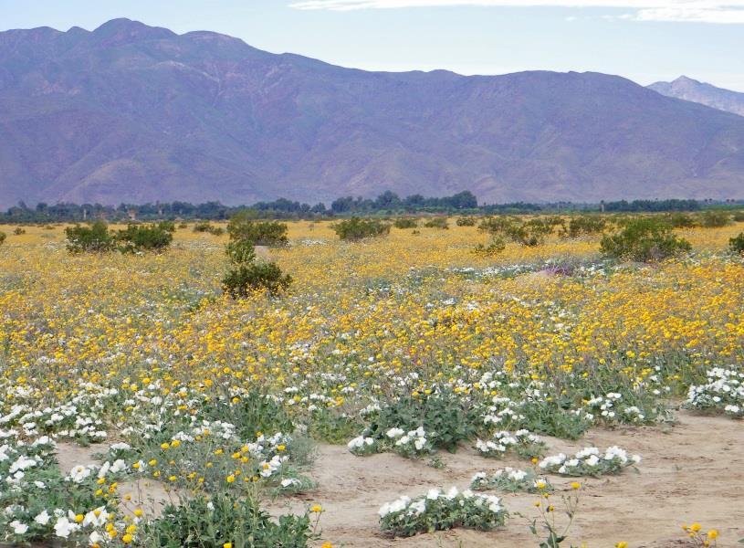
3 In spite of its long legs, this animal geoglyph is believed to represent a mountain lion. It is 54 feet from head to tail. Superbloom or not, brittlebush were in bloom across the southwest. The small one to the right is about twice the size of the brittlebush I planted in my backyard last month. The mature brittlebush on the left is what I hope to end up with in a few years. I spent the following morning checking out wildflowers at Anza-Borrego Desert State Park, although I didn t have the sunny skies I had hoped for.

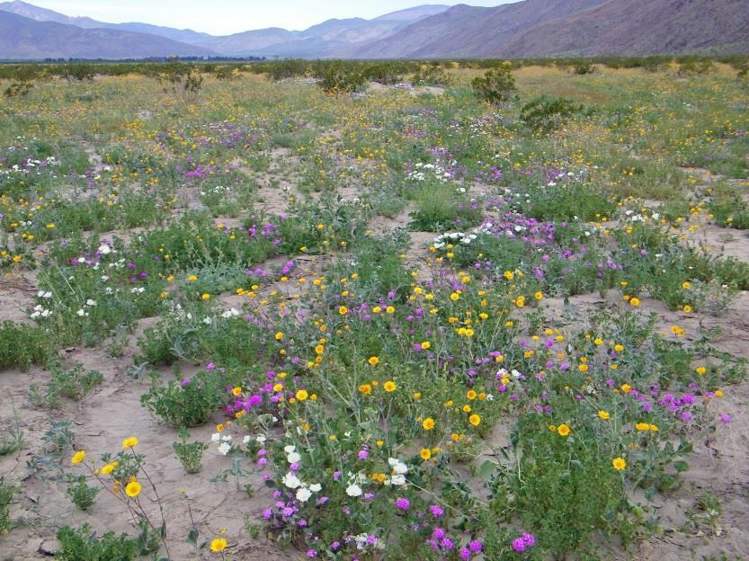
4


5 Smoke Trees were also in bloom. A visiting family is about to be devoured by a Borrego sand serpent. This creature is one of about 130 metal sculptures created by Ricardo Breceda for the Galleta Meadows Estate near the town of Borrego Springs, which is surrounded by the state park.


6 So how long does a superbloom last? Depends on the weather. And it depends on the local caterpillar population, which thrives when the wildflowers do. Uh-oh. I think the caterpillars are turning on me.


7 As long as I was at Anza-Borrego, I decided to hike the stretch of Fish Creek Wash through Split Mountain, a planned stop in the park that I ended up skipping last fall. I passed through the Imperial Sand Dunes on my drive to Yuma.
 Most of the Chocolate Mountains are closed to the public as the military")

8 Fringe of the Chocolate Mountains. (Mmmmm, chocolate!) Most of the Chocolate Mountains are closed to the public as the military uses them as a bombing range. Not a geoglyph, but rather the trace of a pre-columbian Native American trail that connected the Colorado River to today s Imperial Valley.
.")
9 My last stop before Yuma was the Tumco Ghost Town, once the site of a productive gold mine and home to as many as 3000 people. A 1.5 mile trail passes building ruins, a cemetery, and remnants of the mining operation, including these cyanide tanks (a weak cyanide solution was used to separate gold from ore). I spent the next two nights in Yuma, Arizona so that I could spend a full day visiting sites and taking some hikes in the surrounding area.


10 I started my Yuma-area day with a hike along the short trail at Betty s Kitchen, named for a café in a settlement that was once here. Mittry Lake Wildlife Area


11 An example of desert pavement at Imperial National Wildlife Refuge. Over thousands of years, gravel and sand create this interlocking surface common in the region, blackened with desert varnish. Scrape off a layer of this, and you can create geoglyphs that last for centuries. Drive across it, and you ll create tire track patterns on the desert pavement that will also last for centuries. View from Imperial National Wildlife Reserve across the Colorado to some California mountains just to the south of my last stop of the day.


12 While at Imperial National Wildlife Reserve I hiked the Painted Desert Trail through a colorful volcanic landscape.


13 My last stop of the day was Picacho State Recreation Area at the end of a 22-mile gravel and dirt road on the California side of the Colorado River. There I hiked a trail to the old Picacho Townsite and gold mining stamping mill ruins along the Colorado River. Along the trail Upper mill ruins

14 Lower Mill ruins, the Colorado River and view towards Imperial National Wildlife Refuge. As remote as it is, little more than a century ago the town of Picacho had about 3000 people, one of a handful of mining towns served by riverboats that headed up and down the Colorado River. I started heading north the next day, but only as far as Quartzsite, as I planned to spend much of the day exploring the Kofa National Wildlife Refuge. The forecast was for thunderstorms, though, which can pose problems when exploring the gravel and dirt back country roads in the desert. I ended up with mostly overcast skies with a few periods of sunshine and the rain held off until I was finishing up at my last stop of the day. My first stop was at the private Castle Dome Museum home to the Castle Dome City ghost town and mining district, primarily silver galena mining. The ghost town is a collection of a mix of authentic and reconstructed buildings from the area relocated together to an area adjacent to the mining district. There are a number of mines in the area, some up to 700 feet deep.


15 The heart of the recreated town. The 1871 Flora Temple Mine, the second patented mine in Arizona.


16 Brothels were common in mining towns, but most of the displays I ve seen focus on the madams and the women who worked there. I think this Castle Dome display is a first for me, depicting one of their customers instead of one or more of the women. It does note that Madam Toole Handley brought this bathtub with her as she set up business from one mining camp to the next. A couple windows in one of the mine buildings were made with glass bottles cemented together.


17 I then drove several miles along King Road into the heart of Kofa, primarily to check out the scenery. View of Castle Dome in the Castle Dome Mountains south of King Road. View of the Kofa Mountains to the north of King Road.

18 Start at Yuma, Arizona in the heart of the Sonoran Desert. Drive north towards the middle of nowhere. Once you get there, turn right onto a gravel/dirt road. When you reach the end of that road, get out of your vehicle and find the trailhead. It shouldn t be hard to find as it s the only marked trail in more than 1000 square miles. Hike the trail up into the mountains until you reach its end. Look to the left. There s a grove of California fan palms growing here. These are believed to be the only native palms growing in Arizona, leftovers from an era when the climate was cooler and wetter. There are of course a lot of palm trees in Arizona, but those are transplants or descendants of transplants. This is Kofa s Palm Canyon, and the trail is indeed the only trail in the refuge. Basically you can hike almost anywhere in the refuge, although don t touch any unexploded ordnance you may come across the military used to practice here.


19 Some are too small to identify in this picture, but in this small area near the Palm Canyon trailhead I found 10 different types of wildflowers in bloom. The grave of Hadji Ali Hi Jolly in Quartzsite. He was hired to manage camels as part of a failed US Army effort to use camels in its southwest operations (the camels spooked horses, burros and mules).


20 A 38-mile paved road leads to Alamo Lake from the south. This very remote lake was created by the Alamo Dam. My originally planned route leaving the park headed north along remote gravel and dirt roads, but weather radar the night before showed that area getting lots of rain. So I took a longer, but paved route north to Kingman, the only change to my plans due to weather. Leave Interstate 40 west of Kingman, Arizona to drive the Route 66 National Back Country Byway, an original segment of Route 66 that passes through the Black Mountains and Mount Nutt Wilderness. Along original Route 66 in the Black Mountains.

21 Route 66 passes through Oatman, Arizona. The Oatman brochure I have refers to it as an authentic western ghost town and mining camp. It was a gold mining town, and eventually was all but abandoned, but it underwent a tourism renewal. Too over the top and crassly commercial for my tastes, though. I spent the night in Laughlin, Nevada. I was close enough to Vegas that I could have headed home for the night, but I wanted to explore some of the sites in the southern part of Lake Mead Recreation Area the next morning. Lake Mojave s Nevada Telephone Cove. Lake Mojave is created by Davis Dam along the Colorado River below Hoover Dam (which creates Lake Mead).


22 Petroglyphs at Grapevine Canyon, the oldest of which are believed to be almost 1000 years old. I made a couple minor photo stops after visiting Grapevine Canyon and then headed home.
Great Basin Drive, Yosemite to Las Vegas (C18A-3)
") Great Basin Drive, Yosemite to Las Vegas (C18A-3) After finishing up with the California parks, I left Yosemite and entered the Great Basin, which spans a large area east of the Sierra Nevada mountains
Great Basin Drive, Yosemite to Las Vegas (C18A-3) After finishing up with the California parks, I left Yosemite and entered the Great Basin, which spans a large area east of the Sierra Nevada mountains
Dumont Dunes Special Recreation Management Area (SRMA)
") Dumont Dunes Special Recreation Management Area (SRMA) RMA/RECREATION MANAGEMENT ZONE (RMZ) OBJECTIVE(S) DECISIONS Objective Statement: Designate this area as a Special Recreation Management Area. To manage
Dumont Dunes Special Recreation Management Area (SRMA) RMA/RECREATION MANAGEMENT ZONE (RMZ) OBJECTIVE(S) DECISIONS Objective Statement: Designate this area as a Special Recreation Management Area. To manage
BORREGO EXPLORER PHOTO WORKSHOP 2019 Friday, March 22 nd Sunday, March 24 th. With workshop co-leaders Sandy Zelasko & Barbara Swanson
 BORREGO EXPLORER PHOTO WORKSHOP 2019 Friday, March 22 nd Sunday, March 24 th With workshop co-leaders Sandy Zelasko & Barbara Swanson Workshop Itinerary BORREGO EXPLORER PHOTO WORKSHOP 2019 Friday, March
Creating a User-Driven Long-Distance OHV Trail Through Partnering
 Joseph Raffaele Outdoor Recreation Planner U.S. Bureau of Land Management Yuma, Arizona Creating a User-Driven Long-Distance OHV Trail Through Partnering BLM is a multiple-use land management agency within
Big Sandy Ranch Mohave County, Arizona
 Big Sandy Ranch Mohave County, Arizona Photo [9] Deeded land on hillside within the River Ranch parcel Listed for sale exclusively by: Traegen Knight Headquarters West Ltd. PO BOX 1980 St. Johns, AZ 85936
Northern Nevada Road Trip Various Locations, Nevada (N16C)
") Northern Nevada Road Trip Various Locations, Nevada (N16C) I moved to Nevada in January 2016. I had been to the state a number of times, often using Las Vegas as a starting point for road trips around
Northern Nevada Road Trip Various Locations, Nevada (N16C) I moved to Nevada in January 2016. I had been to the state a number of times, often using Las Vegas as a starting point for road trips around
Dusty Boots Unit II. Available Parcels and Informational Summary
 Dusty Boots Unit II Available Parcels and Informational Summary January 2008 Notice to Recipients Other Properties May be available upon Request. Please feel free to contact us with other requests as this
Around Page, Arizona and Southeastern Utah (U17A Part 1)
") Around Page, Arizona and Southeastern Utah (U17A Part 1) For a two-week hiking and sightseeing trip centered on Utah and the Colorado Plateau area, I began with repeat stays in Page, Arizona and Monticello,
Around Page, Arizona and Southeastern Utah (U17A Part 1) For a two-week hiking and sightseeing trip centered on Utah and the Colorado Plateau area, I began with repeat stays in Page, Arizona and Monticello,
Southwest Family Adventure. 7 Days
 Southwest Family Adventure 7 Days Southwest Family Adventure See three amazing National Parks Grand Canyon, Bryce, and Zion on this epic camping trip designed with families in mind. Every day offers magnificent
Ak-Chin Indian Community. Est. 1912
 Ak-Chin Indian Community Population: 575 (related to Tohono O odham and Akimel O'odham people) Size: 22,000 acres (34 sq miles) Industry: Agriculture, industrial park, ranching Attractions: Harrah s Ak-Chin
Guide to the L. F. Manis Photographs
 This finding aid was produced using ArchivesSpace on February 29, 2016. English 2016 The Regents of the University of Nevada. All rights reserved. University of Nevada, Las Vegas. University Libraries.
Guide to the L. F. Manis Photographs
 This finding aid was created by Lindsay Oden on February 27, 2018. Persistent URL for this finding aid: http://n2t.net/ark:/62930/f1vk60 2018 The Regents of the University of Nevada. All rights reserved.
BRYCE CANYON COUNTRY Boulder Mountain Scenic backways itinerary
 BRYCE CANYON COUNTRY Boulder Mountain Scenic backways itinerary Boulder Mountain Area The high plateaus of the Aquarius Plateau (Boulder Mountain), are heavily forested and covered in countless winding
Overland Stagecoach Service through Tucson If it weren t for stagecoaches, Tucson wouldn t have developed to be the town we see today!
 Ring s Reflections by Bob Ring Overland Stagecoach Service through Tucson 1857-1880 If it weren t for stagecoaches, Tucson wouldn t have developed to be the town we see today! Let s set the stage (sorry).
BRYCE CANYON COUNTRY. A twisted tree endures rugged life on the rim of the Paunsaugunt Plateau.
 BRYCE CANYON COUNTRY Grand Staircase - Paunsaugunt Plateau Scenic backways itinerary A twisted tree endures rugged life on the rim of the Paunsaugunt Plateau. Travel to Bryce Canyon Country. Lodging check-in,
Grand Canyon to Las Vegas Bike Conquer over 560km through unforgettable landmarks
 Grand Canyon to Las Vegas Bike Conquer over 560km through unforgettable landmarks Seeing the iconic majesty of the Grand Canyon National Park first hand allows you to experience why it is one of the World
Mazatzal Wilderness Trail Maintenance and Exploration
 Mazatzal Wilderness Trail Maintenance and Exploration March 15-19 (Wednesday - Sunday) Difficulty: Beginner Camping: Car Camping Mileage: Wednesday ~4 miles Thursday ~4-6 miles Friday ~4-6 miles Saturday
Vacation Travel Club 2655 M-63 N. - Benton Harbor, MI (800)
") Vacation Travel Club 2655 M-63 N. - Benton Harbor, MI 49022 1-(800)-524-6240 travel@vacationtravelclub.com Visit the Wonders of the West Starting at $1229.00 per person Area/Region: Western United States
Vacation Travel Club 2655 M-63 N. - Benton Harbor, MI 49022 1-(800)-524-6240 travel@vacationtravelclub.com Visit the Wonders of the West Starting at $1229.00 per person Area/Region: Western United States
One Source, Multiple Challenges: The Future Evolution of Water Policy and the Case of the Colorado River
 One Source, Multiple Challenges: The Future Evolution of Water Policy and the Case of the Colorado River David H. Getches Dean and Raphael J. Moses Professor of Natural Resources Law University of Colorado
Sunrise Ranch 6890 acres, Jeff Davis County, Texas On the Fort Davis Scenic Loop
 Sunrise Ranch 6890 acres, Jeff Davis County, Texas On the Fort Davis Scenic Loop 432-386-2821 Cell 432-426-2024 Office james@kinglandwater.com King Land & Water LLC P.O. Box 109, 600 State Street, Fort
Holiday Home Get away from it all
 Kingman Arizona USA Holiday Home Get away from it all This Dream House has it all! 3 spacious rooms, 1 bathroom remarkable open and convenient floor plan, total 1,296 sq.ft living space, fully solar powered,
Mojave National Preserve Visitor Study
 Mojave National Preserve Visitor Study The Visitor Services Project 2 OMB Approval 1024-0202 Expiration Date: 4-30-98 3 DIRECTIONS One adult in your group should complete the questionnaire. It should only
YELLOWSTONE S I G H T S E E I N G I T I N E R A R Y. follow me on
 T H E 4 - D A Y YELLOWSTONE S I G H T S E E I N G I T I N E R A R Y DAY 1 DAY SITE NAME TIME LENGTH OF HIKE/SIGHTSEEING SITE TYPE TIPS/RESOURCES Heart of The Caldera 5 Min. Pull-In Sight Tower Falls 30
Canyonlands Trip, September Blog 3
 Canyonlands Trip, September 2017. Blog 3 Yesterday (Saturday September 23) we said goodbye to our friends Keith and Zena as they left San Francisco for England after our three week trip in the Western
Frizzell Creek Ranch Summerville, OR $1,400, ± Acres
 Frizzell Creek Ranch Summerville, OR $1,400,000 165± Acres 1 Introduction The Frizzell Creek Ranch is a beautiful 165± acre ranch located in northeast Oregon at the base of the Wallowa Whitman National
Three Sisters Wilderness Oct. 2009
 Three Sisters Wilderness Oct. 2009 I was in Bend, OR and had the whole day to travel back to Boise so I decided to take a hike to the popular Green Lakes and summit the South Sister in Three Sisters Wilderness.
HEADQUARTERS WEST LTD. PHOENIX - TUCSON - SONOITA - COTTONWOOD - ST. JOHNS
 Offered for sale exclusively by: Walter Lane Headquarters West, Ltd. PO BOX 37018 Tucson, AZ 85740 Phone (520) 792-2652 info@headquarterswest.com www.headquarterswest.com General Area Description The Crown
Area Point Man. James Kim
 Trail Lif fe USA Southern Ca alifornia Area Tea am Area Point Man James Kim Program Support Chair John Slagboom So. Cal. Area Spring Family Adventure April 11 th thru 15 th Images from the Mighty Mojave
Colorado s forests are slated to lose thousands of miles of roads through the new OHV Route Designation process. DON T LET IT HAPPEN!
 Colorado s forests are slated to lose thousands of miles of roads through the new OHV Route Designation process. DON T LET IT HAPPEN! This packet identifies many roads that you may lose if you don t act.
National Parks and Beyond
 National Parks and Beyond Canyons, Mesas and Hoodoos Nevada Utah Arizona Red Rock Canyon National Conservation Area Las Vegas, Nevada Begin your adventure under the neon lights of Las Vegas, an oasis in
Presidential Proclamation -- Establishment of the Castle Mountains National Monument
 Presidential Proclamation -- Establishment of the Castle Mountains National Monument ESTABLISHMENT OF THE CASTLE MOUNTAINS NATIONAL MONUMENT - - - - - - - BY THE PRESIDENT OF THE UNITED STATES OF AMERICA
COLORADO TRAIN ADVENTURE
 COLORADO TRAIN ADVENTURE by Melody Hagerman at Travel the Horizon Summary Traveling by rail in Colorado is the most spectacular way to take in its unique scenery. From high above the tracks, you'll enjoy
Southwestern Ag Services, LLC
 Klondyke Country Store & Horse Head Lodge Klondyke, Arizona ±19.5 Acres Offered Exclusively By: Danielle Bechtel Southwestern Ag Services, LLC 480 539 2671 Danielle@swaservices.com www.swaservices.com
Searchlight NV. Est Road is about 35 trail miles south of Searchlight. OLD CORRAL
 EAST LANFAIR VALLEY TRAIL NORTH The East Lanfair Valley Trail runs north/ south from Searchlight, NV to Goffs, CA, a distance of about 48 trail miles. The northern por on is also considered to be part
Bryce Canyon Country.
 Bryce Canyon Country Backways Itinerary - Grand Staircase, Capitol Reef Region Grand Staircase/Capitol Reef/Henry Mountains Adventure off the beaten path and revel in the beauty of Utah s scenic backways.
LIST OF LOCAL SIGHTS AND RECREATION
 LIST OF LOCAL SIGHTS AND RECREATION Pictures of Klamath Falls - http://members.spree.com/sip/sunnidaze/me/kfalls.html One of the local members of Kingsley Field took some pictures of the local area in
CAMP ROCK RANCH JACK KAVANAUGH RMABROKERS.COM
 CAMP ROCK RANCH JACK KAVANAUGH 303.909.1706 JACK@RMABROKERS.COM RMABROKERS.COM CAMP ROCK RANCH COLORADO - CLEAR CREEK COUNTY - UPPER BEAR CREEK ROAD, EVERGREEN The 162±-acre Camp Rock Ranch is surprisingly
Asheville & WNC Hikes
 Asheville & WNC Hikes Amazingly, we have 3,000+ miles of free public hiking trails near Asheville, including 1,600 miles in the Pisgah and Nantahala National Forests, 850 miles in Great Smokey Mountains
Lake Mead Learning Guide
 Lake Mead Learning Guide Author: Mary Beth Goff Editor: Karyn Travaglino Publisher: Road Trip Teacher, LLC by Mary Beth Goff Copyright 2015 Road Trip Teacher, LLC Pages may be copied for same household
The temperature is nice at this time of year, but water is already starting to be scarce.
 In March of 2003, Scott Morrison and I went backpacking in the Grand Canyon. The temperature is nice at this time of year, but water is already starting to be scarce. Another issue with this time of year
The Loneliest Road in America Highway 50, Nevada (N16C)
") The Loneliest Road in America Highway 50, Nevada (N16C) U.S. Highway 50 crosses Nevada s mid-section, entering the state from Utah near Baker and Great Basin National Park, and leaving Nevada in the west
The Loneliest Road in America Highway 50, Nevada (N16C) U.S. Highway 50 crosses Nevada s mid-section, entering the state from Utah near Baker and Great Basin National Park, and leaving Nevada in the west
Beaver Creek State Park
 GENERAL INFORMATION Name of Park/Forest/Facility: Beaver Creek State Park County: Columbiana (St. Clair Township) Address: 12816 Sprucevale Road (ie County Rd 428) (street #, city) East Liverpool, Ohio
Level 1 Geography, 2018
 1 91010R Level 1 Geography, 2018 91010 Apply concepts and basic geographic skills to demonstrate understanding of a given environment 2.00 p.m. Friday 9 November 2018 Credits: Four RESOURCE BOOKLET Refer
SIMON CANYON AREA OF CRITICAL ENVIRONMENTAL CONCERN (ACEC)
") SIMON CANYON AREA OF CRITICAL ENVIRONMENTAL CONCERN (ACEC) Activities: Facilities: Season / Hours: Description: Hiking, backpacking, fishing, picnicking, watchable wildlife. A graveled parking area, picnic
SIMON CANYON AREA OF CRITICAL ENVIRONMENTAL CONCERN (ACEC) Activities: Facilities: Season / Hours: Description: Hiking, backpacking, fishing, picnicking, watchable wildlife. A graveled parking area, picnic
Brinker Creek Ranch. Colorado - Routt County - Yampa
 Located at the base of the Flattops Range in the Steamboat/Vail corridor, Brinker Creek Ranch consists of 1,451 acres ideally suited for high country grazing and native grass hay production. Traditionally
Dreamscapes of the American Southwest Salt Lake City to Las Vegas
 Dreamscapes of the American Southwest Salt Lake City to Las Vegas Day 1: Arches National Park Premium Lodging: The Sorrel River Resort and Spa: Moab, UT We will depart from Salt Lake City at 10 AM for
Posted November 15, :00am Dam bypass completion raises hopes of Arizona landowners, businesses
 Posted November 15, 2010-12:00am Dam bypass completion raises hopes of Arizona landowners, businesses Bypass bridge business to the area KINGMAN, Ariz. -- A busted economy and a tough mortgage market
Cambridge International Examinations Cambridge International Advanced Subsidiary and Advanced Level
 Cambridge International Examinations Cambridge International Advanced Subsidiary and Advanced Level TRAVEL AND TOURISM Paper 1 Core 9395/13 May/June 2015 INSERT 2 hours 30 minutes *3319049881-I* READ THESE
Jemez Mountain Trail Scenic Byway
 Jemez Mountain Trail Scenic Byway The Jemez Mounttaiin Trraiill Sceniic Byway ttwiistts and tturrns tthrrough a vastt tterrrraiin off rriiverr valllleys,, mounttaiins,, and vollcaniic callderras.. Allong
CALIFORNIA S EAST COAST
 John Morrissey (909)821-6356 jlmorrissey@yahoo.com BRE 01400469 CALIFORNIA S EAST COAST River front development opportunity Needles CA Project Area comprises 270 acres of fee simple land with 2,944 lf
1. Waterfall Gully Mt Lofty. 5 Of the Best Hikes in Adelaide
 Adelaide is a beautiful city, and one of the most incredible things about Adelaide is the quality of bushwalking available on the suburban fringe. It is surrounded by the Mt Lofty Ranges, and much of the
Coyote Gulch, Glen Canyon National Recreation Area, Utah, Spring Break 2009
 Coyote Gulch, Glen Canyon National Recreation Area, Utah, Spring Break 2009 This year, Jen and I decided to revive a tradition begun in our early years together: a yearly Spring Break trip to southern
Telluride-to-Moab Alternative Singletrack Options
 Telluride-to-Moab Alternative Singletrack Options Day 1 Day 1 Alternate 1: Galloping Goose to Deep Creek. 18.4 miles, ascent 3,530ft, descent 1,388ft. This is fun, flowey, moderate to intermediate singletrack
Central Overland Trail Utah & Nevada Driving Guide, First Edition, 2016
 Central Overland Trail Utah & Nevada Driving Guide, First Edition, 2016 Page 51 In the third paragraph, second sentence, change 0.4 miles to 0.1 miles. In the fourth paragraph, second sentence, change
Dreamscapes of the American Southwest. Las Vegas to Salt Lake City
 Dreamscapes of the American Southwest Las Vegas to Salt Lake City Day 1: Grand Canyon National Park and Lake Powell Premium Lodging: Lake Powell Resort: Page, AZ Departing from Las Vegas, our journey will
Greenbush Town Hall / Fire Station
 Page 1 of 18 Course Description Greenbush Town Hall / Fire Station Both races start in front of the Greenbush Town Hall / Fire Station, just south of Highway 23 on Sugarbush Road. Parking will be in the
 Augusta 287 200 287 Ovando 200 Lincoln Wolf Creek Craig Garnet 90 GARNET RANGE Drummond 141 Marysville 15 BIG BELT TAINS Granite Philipsburg 1 NGE CREEK Deer Lodge Elliston 12 Helena Rimini Comet 15 287
Non-motorized Trail Plan & Proposal. August 8, 2014
 Town of Star Valley Ranch, Wyoming and the Star Valley Ranch Association in partnership with the USDA Forest Service, Bridger-Teton National Forest, Greys River Ranger District Non-motorized Trail Plan
Difficult Run Stream Valley Park
 Difficult Run Stream Valley Park The more intense mountain bikers have known about for Difficult Run for some time. Equestrians have known it longer. Eight miles of unpaved trail, the Rails to River Trail
Jackson Miles Abbott Wetlands Refuge/Fort Belvoir
 Jackson Miles Abbott Wetlands efuge/fort Belvoir Over the course of millions of years the Potomac iver has gradually shifted its course and sediments have filled-in its old river bed. The main river once
Cataloochee. Fishing Species Rainbow Trout and Brook Trout. Recreation
 Cataloochee River Information The Cataloochee River is located in the historic Cataloochee Valley--a relatively remote part of Smoky Mountain National Park. The campground is a secluded setting and offers
ECUADOR: A Case Study. How have humans changed their environment?
 ECUADOR: A Case Study How have humans changed their environment? How have humans changed their environment? Human beings over the course of history have changed their physical surroundings to meet their
BROCHURE. APPLE HILL WOODS 118 +/- Acres Camino, California. Presented by Jim Copeland
 BROCHURE APPLE HILL WOODS 118 +/- Acres Camino, California Presented by Jim Copeland 1 The Property This 118 acre is a rare gem in the Sierra Nevada foothills. Covered with lush forestland and scattered
Please consider this as page 1 to the attached draft document as described below.
 To: California Energy Commission Dockets Office, MS-4 Docket No. 09-RENEW EO-01 1516 Ninth Street Sacramento, CA 95814-5512 docket@energy.state.ca.us DOCKET 09-RENEW EO-1 DATE MAY 10 2012 RECD. MAY 10
The Mountains Of California By John Muir READ ONLINE
 The Mountains Of California By John Muir READ ONLINE Facts. Over half of the land in the state is covered with mountains. There are two major ranges of mountains in California: The Sierra Nevada and the
PROTECTING ARIZONA S NATURAL AND CULTURAL LEGACY FOR FUTURE GENERATIONS
 PROTECTING ARIZONA S NATURAL AND CULTURAL LEGACY FOR FUTURE GENERATIONS From prehistoric times to the present, this region has always been a signifi cant travel corridor a cultural crossroads. - Andy Laurenzi,
Grand Canyon River Trip Lower Section July 5 th 14 th, 2012
 Grand Canyon River Trip Lower Section July 5 th 14 th, 2012 The Colorado River is an iconic symbol of the American West. It has shaped the human history of this southwestern region from the earliest Native
A Hiking Guide to Trails in the Yuma Area
 A Hiking Guide to Trails in the Yuma Area 1 A Hiking Guide to Trails in the Yuma Area By Geo Montopoli Professor, Arizona Western College (Edition 6 April 8, 2017) Author Contact: gmontopoli@gmail.com
Mines Of Death Valley (Traveler Guidebooks) READ ONLINE
 READ ONLINE") Mines Of Death Valley (Traveler Guidebooks) READ ONLINE If you are looking for the ebook Mines of Death Valley (Traveler Guidebooks) in pdf format, in that case you come on to loyal site. We furnish the
Mines Of Death Valley (Traveler Guidebooks) READ ONLINE If you are looking for the ebook Mines of Death Valley (Traveler Guidebooks) in pdf format, in that case you come on to loyal site. We furnish the
World. Drive Holidays. Roadtrip Los Angeles to Orlando 17 Days / 16 Nights
 Coast 2 Coast - The Ultimate American Road Trip Roadtrip Los Angeles to Orlando 17 Days / 16 Nights Available Summer, Autumn, Spring For most of us, the term Road Trip takes us back to a simpler time in
LOWER SPRING CANYON - CAPITOL REEF
 LOWER SPRING CANYON - CAPITOL REEF Rating: Moderate Hike Length: 5-7 hours (10-11 miles) Gear: Standard Hiking Gear Maps: Fruita, UT; Twin Rocks, UT; Water: A filterable spring a bit over 1/2 way. Recommend
Double Bar Z Ranch 8,690 ± California. Mariposa County Exclusive Agents Allen Alsobrook Jim Watson. Sierra Foothills. La Grange
 Double Bar Z Ranch 8,690 ± California. Mariposa County Exclusive Agents Allen Alsobrook Jim Watson Sierra Foothills. La Grange The Double Bar Z Ranch is a spectacular working cattle ranch. It has been
Photography Guide U.P. of Michigan
 Photography Guide U.P. of Michigan Porcupine Mountains Pictured Rocks National Seashore & Tahquamenon Falls By Bill Welch The U.P. of Michigan Michigan s Upper Peninsula (the U.P.) is a forest covered
NATIONAL ATV / UTV JAMBOREE RIDES
 NATIONAL ATV / UTV JAMBOREE RIDES Note: Rides range from Beginner to Advanced and will last from 2 to 3 hours or an entire day of riding. 1. DESERT RIDE (CLEAR LAKE BIRD REFUGE & LACE CURTAINS/LAVA TUBES)
Mt. Elbert East Ridge
 Mt. Elbert East Ridge Difficulty: Class 1 Exposure: None Summit Elev.: 14,440 feet Trailhead Elev.: 10,400 feet Elevation Gain: 4,100 feet Roundtrip Length: 8.5 miles Trailhead: South Elbert (near Twin
Where, when, and how to discover the best nature photography in America
 Number 129 - January 2014 Where, when, and how to discover the best nature photography in America Twenty-five years of publication Windstone Arch - N 36 24 44.8 W 114 33 14.3 Since I photographed the Valley
Great Basin (B17A) Great Basin 2017-A MarkHitsTheRoad.com - Mark Wasson All Rights Reserved
 Great Basin 2017-A MarkHitsTheRoad.com - Mark Wasson All Rights Reserved") Great Basin (B17A) I took a 9-day road trip to visit sites around the Great Basin. But this could just as easily been called my Leftovers trip. I first headed for the Eastern Sierras area of California
Great Basin (B17A) I took a 9-day road trip to visit sites around the Great Basin. But this could just as easily been called my Leftovers trip. I first headed for the Eastern Sierras area of California
Hiking Las Vegas.com
 Hike: Mt. Wilson via First Creek Canyon route Trailhead: First Creek marked Distance: 10 miles up and back Elevation gain: 3,400 feet Elevation of Peak: 7,070 feet Time: 7 to 9 hours (up and back) Difficulty:
Friday, November 10, 2017
 Friday, November 10, 2017 Andes and Midlatitude Countries Objective: Summarize the main physical features and regions of the Southern Cone. Identify and locate the urban centers and understand the pattern
TAYLOR CANYON RANCH COLORADO - ROUTT COUNTY - STEAMBOAT SPRINGS
 TAYLOR CANYON RANCH COLORADO - ROUTT COUNTY - STEAMBOAT SPRINGS Tucked up against the steep valley shaped by Mt. Pau and rising to the Routt National Forest, Taylor Canyon Ranch is an easily accessible,
January 12-13, 1989 Green Valley RV Park, AZ Tubac & Tumacocori, Southern Trail
 January 12-13, 1989 Green Valley RV Park, AZ Tubac & Tumacocori, Southern Trail 1989 Trip led by Jack Root of Tucson, AZ. Local arrangements made by Harry and Mary Reber of Green Valley, AZ. This outing
White Mountain Wilderness Trails
 The area in which these hikes are located is rugged high mountain country along the Mogollon Rim. This famous eastwest escarpment separates Arizona's high plateau from the basin and range below. These
Dan s Safety Tool Box
 May - Aug 2015 Volume 3, Issue 2 DIRECTOR S Corner Another fun spring season! We started with Pre-Laughlin with 48 PSHOG members. Saturday evening was interesting with a power failure. However, that didn
Cyprus and Greece. We spent time enjoying the views over the sea and slowly strolled back to the hotel to complete our introductory day.
 Cyprus and Greece We are traveling again, this time spending two weeks in the Eastern Mediterranean, first in Cyprus and then in Greece. We have visited both countries before but it has been about 20 years
Matthiessen State Park Dells Area Hike
 90 Easy Hikes Close to Home At the south end of the hike, you ll climb on top of a mound left over from a former coal-mining operation in the park. Not far from Goose Lake Prairie, the town of Morris hosts
This Passport: Revised October 20, 2017, EAM # Discovering the Trails of Webster, NY
 This Passport: Revised October 20, 2017, EAM #161923 Discovering the Trails of Webster, NY The Town of Webster invites you to explore and experience our diverse outdoor adventures! Here s your opportunity
Project Overview. Step 2: Quantifying the Economic Impact of Visitors to Gold Butte. Step 1: Estimating the Stabilized Visitor Count to Gold Butte
 Project Overview Objective: To estimate the economic impacts of designating Gold Butte as a National Conservation Area Approach: Applied Analysis (AA) employed a two-step analytical approach to quantify
ITINERARY OUTLINE FOR BESPOKE TRIPS
 TREK GRAND CANYON 1 ITINERARY OUTLINE FOR BESPOKE TRIPS DAY 1 DEPART / ARRIVE LAS VEGAS We arrive into Las Vegas and transfer 30 minutes directly to our Boulder City hotel with our local team. This evening
PARKS CONNECTING PEOPLE WITH NATURE R.J. CARDIN, DIRECTOR MARICOPA COUNTY PARKS AND RECREATION DEPT.
 PARKS CONNECTING PEOPLE WITH NATURE R.J. CARDIN, DIRECTOR MARICOPA COUNTY PARKS AND RECREATION DEPT. BUCKEYE HILLS PARK AGREEMENTS: Department enters into Special Use Permit to allow Arizona State Rifle
Ghost Towns Of California: Your Guide To The Hidden History And Old West Haunts Of California By Philip Varney
 Ghost Towns Of California: Your Guide To The Hidden History And Old West Haunts Of California By Philip Varney Bodie, Calif. - Ghost towns of America - Pictures - Other ghost towns have been turned into
Sierra Nevada Wildflowers: A Field Guide To Common Wildflowers And Shrubs Of The Sierra Nevada, Including Yosemite, Sequoia, And Kings Canyon
 Sierra Nevada Wildflowers: A Field Guide To Common Wildflowers And Shrubs Of The Sierra Nevada, Including Yosemite, Sequoia, And Kings Canyon National Parks (Wildflower Series) By Karen Wiese These published
DOWNLOAD OR READ : ZION NATIONAL PARK TOUR GUIDE BOOK YOUR PERSONAL TOUR GUIDE FOR ZION TRAVEL ADVENTURE PDF EBOOK EPUB MOBI
 DOWNLOAD OR READ : ZION NATIONAL PARK TOUR GUIDE BOOK YOUR PERSONAL TOUR GUIDE FOR ZION TRAVEL ADVENTURE PDF EBOOK EPUB MOBI Page 1 Page 2 zion national park tour pdf ESCAPE TO ZION NATIONAL PARK. Welcome
Route #2) Mt. Massive - Southwest Slopes
 Mt. Massive - Southwest Slopes") Route #2) Mt. Massive - Southwest Slopes Difficulty: Class 2 Ski: Advanced, D6 / R2 / III Exposure: Summit Elevation: Trailhead Elevation: Elevation Gain: Round-trip Length: Trailhead: County Sheriff:
Route #2) Mt. Massive - Southwest Slopes Difficulty: Class 2 Ski: Advanced, D6 / R2 / III Exposure: Summit Elevation: Trailhead Elevation: Elevation Gain: Round-trip Length: Trailhead: County Sheriff:
San Ignacio Whale Watching
 San Ignacio Whale Watching Day: 1 Welcome to Loreto in Baja! Arrive in Loreto, headquarters for ROW Sea Kayak Adventures operations in Baja! We have been based in this lovely town since 1993 and consider
Drive and Stop Routes
 Drive and Stop Routes Limantour Road 1 - easy and likely productive. From Bear Valley Visitor Center drive back out and turn left onto Bear Valley Rd. Turn left at Limantour Road (the first road). Drive
The Arc of San Diego Leisure Express Trip and Travel Calendar 2015
 The Arc of San Diego Leisure Express Trip and Travel Calendar 2015 Personal and Leisure Services Department 3030 Market Street San Diego, CA 92102 Phone: 619-685-1175, ext. 254 Email: cjenkins@arc-sd.com
Southern Police Institute Alumni Association 64th Annual Conference
 Southern Police Institute Alumni Association 64th Annual Conference Predictive Policing: New Innovations for Policing July 20 th through July 24 th, 2015 Reno, Nevada 2015 SPIAA Conference Event Information
Deep Inside. Copper Mine LEVELED READER P. Visit for thousands of books and materials.
 Deep Inside a Copper Mine A Reading A Z Level P Leveled Reader Word Count: 927 LEVELED READER P Deep Inside a Copper Mine copper ore malachite Written by Tony Francisco Visit www.readinga-z.com for thousands
Vision for national parks highway has Grand County hole
 Vision for national parks highway has Grand County hole BY LEE DAVIDSON THE SALT LAKE TRIBUNE PUBLISHED: DECEMBER 15, 2014 10:37AM UPDATED: DECEMBER 15, 2014 11:20AM For fellow legislators touring the
HIGHLIGHTS: TOUR INCLUDES: +44 (0)
") +44 (0)20 8741 7390 One of the most remote settings on earth, Egypt s Western desert stretches from the eastern banks of the Nile to the Libyan border, encompassing a vast landscape of shifting dunes,
+44 (0)20 8741 7390 One of the most remote settings on earth, Egypt s Western desert stretches from the eastern banks of the Nile to the Libyan border, encompassing a vast landscape of shifting dunes,