AN ARCHAEOLOGICAL SURVEY FOR THE RIVERSIDE WATER SUPPLY CORPORATION WARREN PLANT IMPROVEMENTS PROJECT IN WALKER AND SAN JACINTO COUNTIES TEXAS
|
|
|
- Homer Hancock
- 5 years ago
- Views:
Transcription

1
2 AN ARCHAEOLOGICAL SURVEY FOR THE RIVERSIDE WATER SUPPLY CORPORATION WARREN PLANT IMPROVEMENTS PROJECT IN WALKER AND SAN JACINTO COUNTIES TEXAS BVRA Project Prepared by Brazos Valley Research Associates 813 Beck Street Bryan, Texas Prepared for Riverside Water Supply Corporation Post Office Box 194 Riverside, Texas 77367
3 ABSTRACT Brazos Valley Research Associates (BVRA) conducted a Phase I archaeological survey for the Riverside Water Supply Corporation (WSC) Warren Plant Improvements Project (12.5 acres) under Antiquities Permit William E. Moore was the Principal Investigator, and Edward P. Baxter was the Project Archaeologist. No new sites were found as a result of this investigation. Six previously recorded sites are within or near the Area of Potential Effect (APE), and shovel tests were excavated in the APE on or near these sites in four cases. The six sites in or near the project area are 41SJ42 and 41SJ43 in San Jacinto County and 41WA73, 41WA89, 41WA187, and 41WA283 in Walker County. These sites consist of five unknown prehistoric sites and Camp Huntsville (41WA283), a World War II camp for prisoners of war. No evidence was found that indicates undisturbed portions of any of these sites are within the APE as indicated on the maps provided by the client. The authors recommend that construction be allowed to proceed as planned. Copies of the final report are on file at the Texas Historical Commission (THC), Texas Archeological Research Laboratory (TARL), the Texas Water Development Board (TWDB), BVRA, the engineering firm Stolz Engineering & Associates, Inc. and the Riverside WSC. No artifacts were collected, and no records were curated. ii
4 ACKNOWLEDGMENTS The authors are grateful to the following individuals for their participation in this project. Wayne Stolz of Stoltz Engineering & Associates, Inc. provided maps and visited the project area with the Principal Investigator. Larry Dorman, General Manager at the Riverside WSC, assisted the Project Archeologist by answering questions about changes in the route of the water line. Ray Agostinetti, an employee of the Riverside WSC, also assisted the Project Archeologist. The file search and general records check were performed by Jean Hughes, Curator of Records at TARL. Information regarding site 41WA283 was obtained from talking with local informants James Patton; Barbara Mason; and Sandra E. Rogers, the recorder of the site. The figures that appear in this report were prepared by Lili G. Lyddon of LL Technical Services and Mr. Baxter. Ms. Lyddon also served as editor. iii
5 CONTENTS ABSTRACT...ii ACKNOWLEDGMENTS...iii INTRODUCTION... 1 ENVIRONMENTAL SETTING... 3 ARCHAEOLOGICAL BACKGROUND... 5 METHODS PREVIOUSLY RECORDED SITES IN OR NEAR THE PROJECT AREA RESULTS AND CONCLUSIONS RECOMMENDATIONS REFERENCES CITED Appendix I: Project Area Maps Appendix II: Shovel Test Log iv
6 Figures Figure 1. General Location... 2 Figure 2. The Southeastern Region of Texas... 6 Figure 3. Previous Archaeological Surveys... 9 Figure 4. 41SJ Figure 5. 41WA Figure 6. 41WA Figure 7. 41WA Figure 8. 41WA v
7 INTRODUCTION The Riverside WSC plans to install 98,000 feet (18.5 miles) of water distribution line in northeast Walker County and western San Jacinto County (Figure 1). The water distribution line will be placed on private land, on land owned by the Texas Department of Criminal Justice (TDCJ), and within the rights-of-way of Farm-to-Market Road 980 and State Highway 19. There are three sizes of pipe that will be installed. The diameter of the pipe is six inches, eight inches, and twelve inches. The pipe will be placed in a trench beneath four feet of cover, and the width of the trench will be thirty inches or less. The construction easement will be twenty feet, and the permanent easement will be fifteen feet. Other proposed improvements include four water treatment plants. They are the Warren Plant with a footprint of 100 feet by 100 feet, the Cedar Hill Plant with a footprint of 150 feet by 200 feet, and the Acorn Hill and Huntwood plants with footprints of 150 feet by 150 feet. In addition, the Gospel Hill Stand Pipe is proposed, and it will have a footprint of 125 feet by 125 feet. Funding will be provided by the TWDB. The TWDB representative for the project is Darrell Nichols, and the Environmental Coordinator is Chris Jurgens. The project area is covered by two 7.5' USGS topographic maps. They are Riverside ( ) and Staley ( ). They appear as six maps in Appendix I. The proposed construction is in an area where significant prehistoric and historic sites have been recorded, and six sites are within or near the APE. Therefore, an investigation by a professional archaeologist was requested by the THC. In order to satisfy this requirement, the Riverside WSC retained BVRA to perform this service that was conducted under Antiquities Permit
8 Figure 1. General Location 2
9 ENVIRONMENTAL SETTING General The project area is located within the Austroriparian biotic province as defined by Blair (1950) and includes the Gulf coastal plain from the Atlantic Ocean to eastern Texas. The western boundary of this province in Texas is approximated by a line running north from western Harris County to western Red River County. The western boundary of the Austroriparian is also the western boundary of the main body of the pine and hardwood forests of the eastern Gulf coastal plain (Blair 1950:99). According to Thornthwaite (1948), these forests are limited on the west by available moisture. Flora The Project Area is located within the loblolly pine, shortleaf pine, and upland hardwood plant community as defined by the United States Forest Service for the four National Forests in East Texas. According to Ippolito (1983:6-7), the major forest cover types in this community include loblolly pine, shortleaf pine, slash pine, post oak, southern red oak, white oak, black oak, blackjack oak, black gum, sweet gum, American elm, red maple, hickories, and beech. Approximately 70 percent of East Texas is currently occupied by the Piney Woods with Post Oak Savannah and Blackland Prairie in the rest of the region (Boyd and Howard 1988:4). Keller (1974: ) believes that deciduous trees may have been more numerous during most of the Holocene and were probably more important resources to prehistoric populations than the modern flora would suggest. Fauna The vertebrate fauna of the Austroriparian is considered typical of that to the east. Blair (1950:99) states that at least 47 species of mammals occur or have occurred there in recent times. Known types include at least 29 species of snakes, 10 lizards, 2 land turtles, 17 anurans, and 18 urodeles. Ippolito (1983:11) states that there is an inadequate sample of faunal material for the area in an archaeological context. Therefore, assumptions concerning prehistoric exploitation of animals must be based on historical accounts and current populations. 3
10 A study by Keller (1974:78-81) of the paleoecology of the middle Neches region lists those mammals most likely to have been hunted in the area. They are Whitetail deer, Cottontail rabbit, Swamp rabbit, Grey squirrel, Fox squirrel, Flying squirrel, Raccoon, Opossum, Red fox, Grey fox, Woodchuck, Bobcat, Spotted skunk, Striped skunk, Mink, Otter, Long-tailed weasel, and Muskrat. According to Ippolito (1983:11), this list excludes many species of birds, especially migratory fowl, and fish that can still be found in the area. Species not found in the area today include black bear, beaver, and wild turkey. These were once numerous but were eradicated by uncontrolled hunting and timber harvesting that irreparably altered their habitats. Climate The following climatic information was taken from the Texas Almanac: published by the Dallas Morning News (2004). The weather in the two counties consists of hot summers and cool winters. An occasional cold front may cause temperatures to drop below freezing, sometimes quite suddenly. The January mean minimum temperature for San Jacinto County is 36 degrees Fahrenheit, while the July mean maximum temperature is 93 degrees Fahrenheit. The January mean minimum temperature for Walker County is 38 degrees Fahrenheit, while the July mean maximum temperature is 94 degrees Fahrenheit. An annual growing season of 234 days above freezing is typical. Prevailing winds are from the south-southeast. Rainfall is uniformly distributed throughout the year, and snowfall is rare. Soils According to the General Soil Map in the published soil survey for Walker County (McClintock et al. 1979), the Walker County portion of the project area is located within the Falba-Almina-Arriola association. Soils in this association consist of moderately deep and deep, sandy and loamy, nearly level to sloping soils on uplands. According to the General Soil Map in the published soil survey for San Jacinto County (McEwen et al. n.d.), the San Jacinto County portion of the project area is located within the Laska-Colita-Oakhurst Association. Soils in this association consist of nearly level to strongly sloping, moderately well drained and somewhat poorly drained, moderately rapidly permeable, moderately permeable, and very slowly permeable loamy soils. 4
11 ARCHAEOLOGICAL BACKGROUND According to a bibliography prepared by William E. Moore and published by the THC (Moore 1989), the project area is located in the Southeastern Region of Texas (Figure 2). Most of the early information for San Jacinto and Walker Counties is based on projects in neighboring counties such as the Lake Livingston reservoir study in Polk and San Jacinto counties (Nunley 1963, McClurkan 1967, 1968; Ensor and Carlson 1988), Lake Conroe in Montgomery County (McNatt 1978; Shafer 1968; Shafer and Stearns 1975), Lake Creek Reservoir in Montgomery County (Bement et al. 1987), and the Gibbons Creek Mine in Grimes County (Rogers 1993, 1994). Most of the archaeological work in San Jacinto and Walker counties revealed the presence of sites associated with the Late Prehistoric period of Texas prehistory based on the presence of arrow points and ceramics. Sites dating to the Paleo-Indian period are rare and are usually identified by isolated finds of early projectile points found on the surface without a direct association of subsurface cultural materials. Sites dating to the Early Archaic or pre-ceramic period are also rare, although examples are known. In 1985, a statistical overview of prehistoric sites in Texas was published by the Office of the state Archeologist (Biesaart et al. 1985). At the time of this publication, San Jacinto County contained 1 Paleo-Indian site, 24 Archaic sites (one dating to the Early Archaic), and 114 Late Prehistoric sites. Walker County contained no Paleo-Indian sites, 3 Archaic sites, and 15 Late Prehistoric sites. This source provides statewide, regional, and county statistics. Although it is outdated, being published twentyfour years ago, it provides valuable comparative data for what was known at that time and the current status of Texas archeology. Unfortunately, this document does not provide site numbers. No attempt was made by the authors to identify the number of Paleo-Indian, Archaic, and Late Prehistoric recorded in San Jacinto and Walker counties at this time. It is known, however, that the number of known sites in San Jacinto County and Walker County at the time of this study has increased from 139 sites in San Jacinto County and 18 sites in Walker County to 217 and 297 sites, respectively, due to archaeological surveys by professional archaeologists and continued work by amateur archaeologists and the Houston Archeological Society. As stated above, sites with Paleo-Indian components are rare in Southeast Texas. The authors are not aware of any sites that can be identified as pure Paleo-Indian. One of the more significant pre-ceramic sites in the area is 41MQ41 in Montgomery County, a site found at Lake Conroe by archaeologists from Texas A&M University (Shafer and Stearns 1975). At the time this site was investigated, it represented the oldest cultural remains recovered from the Lake Conroe Area. The findings were significant in that they confirm an earlier hypothesis that prehistoric sites having considerable antiquity are present on older landforms in the area. Earlier work in the area tended to sample sites situated on more recent landforms; therefore, the materials from these sites are relatively late. 5
12 Figure 2. The Southeastern Region of Texas (After Moore 1989) 6
13 Formal tools found at 41MQ41 include a San Patrice point (viewed by some archaeologists as a transitional point between the Paleo-Indian period and the Early Archaic period) and other stemmed biface forms not present in the Late Lithic and subsequent periods. Shafer and Stearns (1975:39) describe 41MQ41 as a "lightly occupied, probably intermittent campsite used during the Early and Middle Lithic periods." This dates the site to sometime between 8000 B.C. and 1000 B.C. Another probable preceramic site (41WA99) in the area is in Walker County. It was discovered during a survey by Moore Archeological Consulting (Moore et al. 1999). Shovel testing revealed a large dart point, flakes, and no ceramics on a sandy hill high above the nearest creek. Additional evidence of Paleo-Indian era sites in the area is known from a surface-collected Angostura point at 41WA116 (Moore 2001), and a possible Angostura point found on the surface by the landowners of site 41WA100 (Moore 1990), and a San Patrice point found on the surface by the landowner of site 41WA83 (Moore 1983). A Scottsbluff point was reported by Keller and Weir (1979) at site 41SJ160 in San Jacinto County. The primary author of this report viewed this specimen at the curation facility at Stephen F. Austin State University and concluded that it is a large stemmed point and not a Scottsbluff point. Sites attributed to the Caddo are not known in the area; however, a single ceramic sherd identified by Dee Ann Story as Holly Fine Engraved (Moore 1986) was found on the surface at 41WA55, a site on the border of Walker and San Jacinto counties and its presence suggests Caddoan interaction in the area. Sites containing artifacts that date to the time of contact between Europeans and native Indians are also rare in the area. The project area was part of the area inhabited by the historic Akokisa (Newcomb 1986), but no direct evidence of sites associated with this group has been documented in either county. One of the largest surveys in Southeast Texas (3570 acres) was conducted at Lake Creek Reservoir in adjacent Montgomery County by archeologists from the Texas Archeological Survey (Bement et al. 1987). Their study area is also in the area occupied by the Akokisa, but they found no evidence of sites dating to the contact period. In the late eighteenth century and early nineteenth century, many tribes living in the Southeast part of the United States were being forced westward into Texas because of Anglo-American expansion into their traditional territories. Two sites containing artifacts associated with one of these tribes, the Alabama-Coushatta, have been documented in San Jacinto County. These are 41SJ136 in the Sam Houston National Forest and 41SJ67 located east of the forest near the town of Shepherd. Site 41SJ67 is the best documented evidence of a site associated with this tribe. This site was excavated by members of the Houston Archeological Society in 1969 under the supervision of Dick Ping Hsu (1969). European-made artifacts associated with burials included glass trade beads, clothing decorated with glass beads and other burial items. The site is believed to have been occupied during the 1840s or 1850s. 7
14 Historic sites dating to the early settlement of the two counties are too numerous to mention here. Examples include log cabins such as the early 19 th century structure in San Jacinto County (41SJ217) that dates to the 1840s, farmsteads dating to the 19 th and 20 th centuries, and early towns and settlements such as Cincinnati on the Trinity River (41WA95). Cemeteries are sometimes associated with early settlements such as the one at Cincinnati (41WA95) and also churches. Isolated graves and private family cemeteries are also known in the area. The only community that is within the project area is Riverside, which is located on Farm-to-Market Road 405 east of State Highway 19 and thirteen miles northeast of the town of Huntsville. Riverside was founded in 1872 by the Houston and Great Northern Railroad on the west bank of the Trinity River in order to provide easy access for freight that was being shipped by rail and on the river. The early economy of the area was cotton, but this changed to lumber and livestock as they became important. By the middle of the 1880s, the population of Riverside was 200, and the town boasted two hotels, two general stores, and a gristmill. Ten years later, there were three churches, two schools, two sawmills, a cotton gin, a saloon, and a restaurant. The population was reduced to only fifty by In 1920, fuller s earth was discovered and, this caused a boom to the economy as two refining plants were established near the town. In 1933, there were seven businesses, three churches, two schools, and a population of 300. In 1968, Riverside incorporated, and a community fire department was organized in The population consisted of 451 residents in 1990 and 425 residents in The information cited above was compiled by James L. Hailey (2009) who posted it on The Handbook of Texas Online. Additional information about Walker County can be found in two sources by Crews (1976) and Kathleen and Clifton St. Clair (1982). According to the Atlas, there have been 186 formal surveys by professional archaeologists that involve portions of the current project area and vicinity. Of this number, 60 were linear surveys dating from 1975 to 2004, and 123 were area surveys dating from 1963 to 2008 (Figure 3). Information regarding the sites not depicted in Figure 3 can be found on the Atlas. Six sites have been recorded in or near the project area. They are 41SJ42, 41SJ43, 41WA73, 41WA89, 41WA187, and 41WA283. Five of these are unknown prehistoric sites with no diagnostic artifacts, and one (41WA283) is a former World War II prisoner of war camp known as Camp Huntsville. The first investigation in the area by professional archaeologists was associated with the proposed Livingston Reservoir in Polk, San Jacinto, Trinity, and Walker counties in 1961 and This study was performed by the Texas Archeological Salvage Project (TASP) with assistance from members of the Houston Archeological Survey. This study recorded the first known sites in San Jacinto County and the first known sites in Walker County. A report of this investigation was authored by Nunley (1963). 8
15 Figure 3. Previous Archaeological Surveys The earliest investigation involving the project area was an informal survey by William E. (Bill) Moore in the 1970s (Moore 1976). At the time, Moore was a student at Sam Houston State University with an interest in archaeology. He obtained a county highway map for Walker County and drove many of the roads looking for evidence of sites based on artifacts in road cuts. He also identified sites based on conversations with landowners and local collectors. This survey identified 34 previously unrecorded sites. Two of these sites (41WA73 and 41WA89) are within the current project area. During this time, Moore also recorded sites in San Jacinto County, but not one of these sites are in the current project area. 9
16 In 1990, James E. Corbin conducted an archaeological survey for a proposed water line expansion project in San Jacinto and Walker counties for the Riverside WSC (Corbin 1990). Two sites (41SJ42 and 41SJ43) were recorded. Site 41SJ42 is on the opposite side of the APE, and site 41SJ43 is within the current project area. In 1996, an archaeological survey of a proposed water line project was performed by Moore Archeological Consulting (Moore et al. 1999). The study area consisted of miles on land owned by the Texas Department of Corrections. Five new sites (41WA184-41WA188) were recorded, and one previously recorded site (41WA65) was visited and assessed. Only one site (41WA187) recorded during this survey is within the current project area. In 2005, the Texas Historical Commission asked stewards to identify and record all World War II sites in their respective counties to commemorate the 60 th anniversary of this conflict. Archeological Steward Sandra E. Rogers took time from her busy schedule to visit and document Camp Huntsville (41WA283), the World II camp that housed prisoners of war from Germany and Japan. This effort resulted in a very thorough study of this site. In 2008, a survey for the proposed Arbuckle Pipeline was conducted by Bo Nelson working with Archeological & Environmental Consultants, LLC. This study recorded one prehistoric site (41WA290), but it is outside the current project area. Several overviews of the area provide valuable data for Walker County and vicinity. Some of the major works are discussed below. In 1978, a file and literature search was conducted by TARL in an effort to prepare an overview of the cultural resources within the Davy Crockett, Sam Houston, Angelina, and Sabine National Forests of Texas. Information in the TARL files was compiled by Ross Fields and Rosario Casarez. This report (Fields 1979) provides a good synthesis of central East Texas prehistory and assesses 17 sites in Walker County. John Ippolito (1983), Forest Service Archeologist for the National Forest, Southern Region, compiled an overview of cultural resources present in the National Forests of Texas that includes Walker County. This volume presents a short history of Texas forests and discusses such topics as environment and ecosystems, culture history, past archaeological activities relevant to the National Forests in Texas, and direction for future cultural resource investigations. A map depicting areas surveyed within the forest and a list of compliance projects with acreage, date conducted, and sites found are included. 10
17 More recently, five studies have been published which are worthy of mention. These are Archeology in the Eastern Planning Region, Texas: A Planning Document compiled by the Department of Antiquities Protection (Kenmotsu and Perttula (1993); Roger G. Moore's (1995) Ph.D. dissertation entitled The Mossy Grove Model of Long-Term Forager-Collector Adaptations in Inland Southeast Texas; Volume 66 of the Bulletin of the Texas Archeological Society which reviews the current state of Archeology in Texas and contains a chapter devoted to Southeast Texas (Patterson 1995); an archaeological study by the Texas Parks and Wildlife Department at the Huntsville Fish Hatchery in Walker County (Davis et al. 1994:20-33); and a database by Moore Archeological Consulting (Moore et al. 1999). The database was created from encoding site data for all known sites in Walker County at the time of this project. This database was an attempt to define settlement rules specific to Walker County through the application of an empirical analysis cross-tabulating site data with environmental variables and was based, as stated above, on the computerization of data from all of the existing TARL site records for the county. Moore used data from 181 sites for this study; however the analyses utilized only those sites with prehistoric components since the sample size for historic sites is inadequate and the settlement criteria for historic sites location are much different and currently more ambiguous than for prehistoric sites. This study revealed that prehistoric sites seem to be found throughout the county where suitable landforms (sandy ridges and knolls) exist in close proximity to dependable water sources. The only large concentrations of prehistoric sites are the result of large area surveys. Single sites along major drainages should not be interpreted as sparse use of an area; rather, these sites were most likely recorded by individuals with restricted access to larger areas. 11
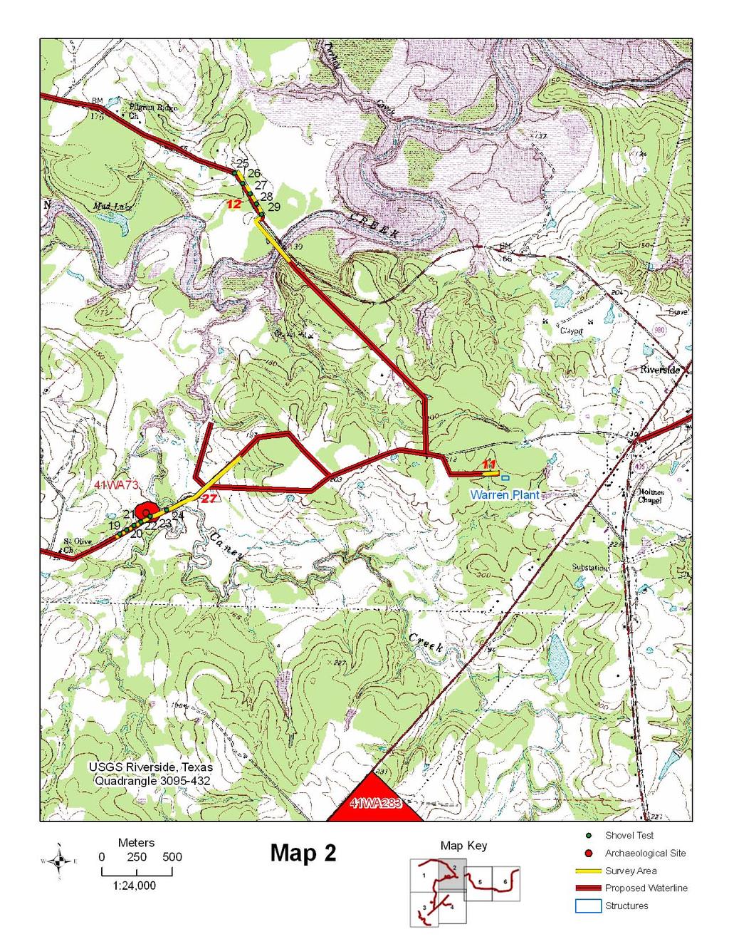
18 METHODS Prior to entering the field, the Texas Archeological Site Atlas and the files at TARL were checked for previously recorded sites and past surveys in the project area and vicinity. Several documents were reviewed during the planning stages of this project. These are a planning document by the THC (Biesaart et al. 1985), an Archeological bibliography for the Southeastern Region of Texas published by the THC (Moore 1989), and all volumes of the Abstracts in Texas Contract Archeology published by the THC. The interested reader is referred to these sources for additional information regarding the prehistory of this area. The soil surveys for San Jacinto County (McEwen et al. n.d.) and Walker County (McClintock, Jr., et al. 1979) were reviewed in order to identify the general soil types present in the APE. The survey was documented through the utilization of Microsoft Word and Excel documents. Location data was collected and documented with a Garmin GPS-aided computer topographic program, National Geographic Topo and ESRI ArcMap. A Kodak digital camera was used to document the project, and all photographs were enhanced using Adobe Photoshop software. The field survey was conducted on July 28-31, The majority of the project area was visually inspected during a windshield survey designed to look for historic buildings and cemeteries that might be affected by the proposed water line. A portion of the project area was on private property away from roads where permission to access the APE was not obtained was not included in the windshield survey. Portions of the pipeline segment of the project area near creeks and previously recorded sites were chosen prior to the survey to be subjected to an intensive survey if needed. A total of 27 areas were surveyed. The areas surveyed were subjected to a visual inspection, shovel probes, and shovel tests where warranted. All shovel tests were screened through quarter-inch mesh hardware cloth. The 27 areas are discussed in detail below. Area 1 This area is 900 meters long and is on the south side of Farm-to-Market Road 980. It crosses Burge Branch and a tributary of Burge Branch, both dry intermittent streams. A visual inspection revealed clay and bedrock at the surface. At the time of this investigation, the area had been disturbed by construction associated with a previous water line. Corbin had surveyed the area in 1990 for a water line in the same easement (see Archaeological Background above). No shovel tests were excavated. 12
19 Area 2 This area is 150 meters long and is on the east side of Farm-to-Market Road 980. It crosses an unnamed intermittent tributary of Carolina Creek. A visual inspection revealed clay and bedrock at the surface. At the time of this investigation, the area had been disturbed by construction associated with a previous water line. Corbin surveyed the area in 1990 for a water line in the same easement (see Archaeological Background above). No shovel tests were excavated. Area 3 This area is 1025 meters long and is on the west side of Farm-to-Market Road 980 where it crosses East Carolina Creek. Site 41SJ42 is on the west side of the road and the north bank of the creek. Corbin recorded this site in 1990 during a survey for a water line in the same easement as this project (see Archaeological Background above). On the north side of the creek, the area loops eastward away from the highway to circumnavigate a swamp. Surface visibility in this area was 90 percent due to exposed earth from a buried gas line and a recently installed water line. The area in the vicinity of the site was inspected through a surface inspection of the highway cut bank and two shovel tests. Six shovel tests were excavated between the site area and the creek. The south side of the creek was subjected to a visual inspection and five shovel tests. At the time of this investigation, this area was in mowed grass, and the surface visibility was 40 percent. It consisted of a flat plateau running from the creek to a hill slope and a hill. There was shallow sand on the hill and slope. In the flat area clay was present with no sand observed. The road cut through the hill in the right-of-way, and this area was also inspected. All of Area 3 had been disturbed by construction of a previous water line. Area 4 This area is 180 meters long and is on the east side of Farm-to-Market Road 980. It parallels East Carolina Creek to the east, which flows from north to south. Previously recorded site 41SJ43 (Figure 4) is plotted on the maps at TARL as being on both sides of the road (including the center of the road). Corbin recorded this site in 1990 during a survey for a water line in the same easement (See Archaeological Background above). This area was investigated through a surface inspection of both sides of the road and two shovel tests in the proposed water line easement. Surface visibility in portions of Area 4 was estimated at 75 percent. Based on the two shovel tests, the sandy mantle in this area was only cm over clay. This area had been disturbed by construction of a previous water line. 13
20 Figure 4. 41SJ43 Area 5 This area is 450 meters long and is on the south side of Farm-to-Market Road 980 where it crosses West Carolina Creek. On the east side of the creek is a hill with bedrock at the surface. On the west side of the creek is a low area with clay at the surface. This area has been disturbed by construction of a previous water line. Visual inspections and shovel probes were conducted. Corbin surveyed this area in 1990 for a proposed water line in the same easement (See Archaeological Background above). No shovel tests were excavated. 14
21 Area 6 This area is 200 meters long and is on the south side of Farm-to-Market Road 980 where it crosses an intermittent tributary of Bethea Creek. Area 6 had been disturbed by construction of a previous waterline. Clay and bedrock was observed at the surface. Corbin surveyed the area in 1990 for a water line in the same easement (See Archaeological Background below). No shovel tests were excavated. Area 7 This area is 400 meters long and is on the south side of Farm-to-Market Road 980 where it crosses an intermittent tributary of Bethea Creek. Area 7 had been disturbed by construction of a previous water line. Clay was observed at the surface. Corbin surveyed the area in 1990 for a water line in the same easement (See Archaeological Background above). No shovel tests were excavated. Area 8 This area is 280 meters long and is on the south side of Farm-to-Market Road 980 where it crosses an intermittent tributary of Bethea Creek. Area 8 had been disturbed by an old roadbed and mining activities. Corbin surveyed the area in 1990 for a water line in the same easement (See Archaeological Background above). No shovel tests were excavated. Area 9 This area is 120 meters long and is on the south side of Farm-to-Market Road 980 where it crosses an intermittent tributary of Bethea Creek. The area was inspected through a visual inspection, and clay and bedrock were observed at the surface. Area 9 has been disturbed by construction of a previous water line. Corbin surveyed this area in 1990 for a water line in the same easement (See Archaeological Background above). No shovel tests were excavated. 15
22 Area 10 This area is 300 meters long and is on the southwest side of Farm-to-Market Road 980 where it crosses Bethea Creek. At the time of this study, the area was wooded with a section that had been recently mowed. The route on the northwest bank of Bethea Creek had been cut and graded in the past by construction of a previous water line that removed about 2.5 feet of the ground surface. The area was visually inspected, and clay was observed on the surface on the southeast bank of the creek. Corbin surveyed the area in 1990 for a water line in the same easement (see Archaeological Background below). No shovel tests were excavated. Area 11 This area is 100 meters long and is in the woods parallel to a small, unnamed road near the site of the proposed Warren water treatment plant where it crosses an intermittent unnamed tributary of Caney Creek. The creek in this area was observed to be a slight depression with no water present. No shovel tests were excavated. Area 12 This area is 800 meters long and crosses Harmon Creek. It begins on the southwest side of the road and, after crossing the creek it moves to the northeast side of the road. The area on the southwest side follows the disturbed old roadbed of Farmto-Market Road 980, now on private land. This area was visually inspected, and no shovel tests were excavated. Five shovel tests were excavated in that portion of the area on the northeast side of the road within the right-of-way since landowner permission to work on private property had not been obtained. Later, permission was obtained from the landowner to walk on his property and visually inspect the surface. The area had been disked along the proposed easement, and this resulted in excellent visibility of the ground surface. The landowner stated that he had never found any artifacts at that location in many years of plowing. The shovel tests revealed sand over clay on the slope and clay in the bottomland. 16
23 Area 13 This area is 150 meters long and is on the north side of side of Farm-to-Market Road 980 near the location of site 41WA187 (Figure 5). The proposed route is on a rocky hilltop that has been cut through by road construction. The proposed route has been disturbed by the construction of another pipeline at that location. The site, which was recommended to be ineligible, lies just to the north of the proposed route. A surface inspection revealed no artifacts or soil depth. No shovel tests were excavated. Figure 5. 41WA187 17
24 Area 14 This area is 900 meters long and is on the southeast side of State Highway 19 just inside the plotted boundary of site 41WA283, a World War II prisoner of war camp (Figure 6). At the time of this study, the area was in pasture and being used as a cattle ranching operation. The area was visually inspected, and no features associated with this site were observed. Clay was observed at the surface. No shovel tests were excavated. Area 15 This area is 370 meters long and is on the north side of Obannon Drive where it crosses an intermittent unnamed tributary of Caney Creek. The area was visually inspected, and clay was observed on the surface on both sides of the creek. No shovel tests were excavated. Area 16 This area is 140 meters long and is on the north side of Obannon Drive where it crosses an intermittent unnamed tributary of Caney Creek. The area was visually inspected, and clay was observed on the surface on both sides of the creek. No shovel tests were excavated. Area 17 This area is 200 meters long and is on the southeast side of State Highway 19 where it crosses an unnamed intermittent tributary of Rocky Creek. The area was visually inspected, and clay was observed on the surface on both sides of the creek. No shovel tests were excavated. Area 18 This area is 200 meters long and is on the southeast side of State Highway 19 where it crosses an unnamed intermittent tributary of Harmon Creek. The area was visually inspected, and clay was observed on the surface on both sides of the creek. No shovel tests were excavated. 18
25 Figure 6. 41WA283 Area 19 This area is 260 meters long and is on the north side of Acorn Drive where it crosses an unnamed intermittent tributary of Harmon Creek. The area was visually inspected, and clay was observed on the surface on both sides of the creek. No shovel tests were excavated. Area 20 This area is 200 meters long and is on the east side of Acorn Drive where it crosses an unnamed intermittent tributary of Harmon Creek. The area was visually inspected, and clay was observed on the surface on both sides of the creek. No shovel tests were excavated. 19
26 Area 21 This area is 120 meters long and is on the west side of an old, unnamed subdivision road at the western boundary of site 41WA89 (Figure 7). At the time of this study, the sandy mantle in this portion of the site had been removed by activities associated with road construction, leaving clay at the surface. The remaining portion of the site is on the hill to the east of the road. Due to recent pipeline construction in the area, the surface visibility was estimated at 90 percent. This area was investigated by a surface inspection; shovel probes, and two shovel tests. Area 22 This area is 200 meters long and parallels an old unnamed subdivision road on the north and west sides. Part of the route is on a rise above an unnamed tributary of Harmon Creek. Recent pipeline activity has resulted in 90 percent surface visibility. The area was inspected visually, and no shovel tests were excavated. Area 23 This area is 300 meters long and is on the east side of Wood Farm Road where it crosses an unnamed intermittent tributary of Rocky Creek. The area was visually inspected, and clay was observed on the surface on both sides of the dry creek. No shovel tests were excavated. Area 24 This area is 200 meters long and is on the east side of Wood Farm Road where it crosses an unnamed intermittent tributary of Caney Creek. The area was visually inspected, and shallow sand over clay was observed on the surface. The area had been disturbed by erosion. No shovel tests were excavated. Area 25 This area is 115 meters long and is on the east side of Wood Farm Road. Previously recorded site 41WA290 is on the east side of the road, but it is outside the project area. Area 25 was visually inspected, and no shovel tests were excavated. The area had been previously surveyed in 2008 by Bo Nelson who recorded this site. 20
27 Figure 7. 41WA89 21
28 Area 26 This area is 150 meters long and is on the south side of Wood Farm Road where it crosses a small, unnamed intermittent tributary of Harmon Creek, which is only a small swale at this location. This area was visually inspected, and no shovel tests were excavated. Area 27 This area is 890 meters long and is on the southeast side of Wood Farm Road where it crosses Caney Creek. The area was visually inspected and found to be disturbed by agricultural practices. A visual inspection revealed clay at the surface over much of the area. The proposed water line passes through the plotted location of site 41WA73 (Figure 8). Six shovel tests were excavated on the hill overlooking the floodplain and in the area where the site is plotted on the maps at TARL. These tests revealed shallow sand over clay on the hill and upper slope, deep sand on the toe slope, and clay in the bottomland. The site was recorded as two flakes found in sand along the road cut. They were probably found on the toe slope where sandy soil is present. No artifacts were observed or collected. The entire road cut area and the site area in the proposed easement was visually inspected. 22
29 Figure 8. 41WA73 23
30 PREVIOUSLY RECORDED SITES IN OR NEAR THE PROJECT AREA 41SJ42 James E. Corbin recorded this site in 1990 during an archaeological survey for a proposed water line expansion project (Archaeological Background above). It was identified by the presence of a few flint flakes eroding out of the upper portions of a buried soil that was exposed in the road cut on the west side of State Highway 980 approximately 2.0 meters below the existing ground surface at the edge of the uplands adjacent to East Carolina Creek. Artifacts present included debitage made from local materials and burned rock. Due to an absence of diagnostic artifacts, the age of this site is not known. Although that portion of this site in Corbin s project area has been disturbed through road construction activities, Corbin (1990:10) states in his report that that significant undisturbed portions of this site may be present on the west side of the highway out of his project area. Corbin recommended that construction be allowed to proceed since the APE did not reach the level of the buried soil at the site. There is no site form on file at TARL for this site. The location of this site is depicted on the Staley topographic quadrangle in Appendix I. 41SJ43 James E. Corbin recorded this in 1990 during an archaeological survey for a proposed water line expansion project (see Archaeological Background above). It was identified by the presence of cultural materials that he describes as primarily flakes eroding from a buried soil identical to that of 41SJ42 at a depth of 2.5 meters below the existing ground surface at the edge of the uplands adjacent to East Carolina Creek on the east side of State Highway 980. Artifacts present include debitage made from silicified wood and a core made from coarse-grained quartzite. Due to an absence of diagnostic artifacts, the age of this site is not known. Although that portion of this site in Corbin s project area has been disturbed through road construction activities, Corbin (1990:10) states it is probable that the largest portion of the remainder of the site is on the east side of the road in the immediate construction area. Corbin recommended that construction be allowed to proceed since the APE did not reach the level of the buried soil at the site. There is no site form on file at TARL for this site. The location of this site is depicted on the Staley topographic quadrangle in Appendix I. 24
31 41WA73 Bill Moore recorded this site in 1974 during his informal survey of Walker County (see Archaeological Background above). It was identified on the basis of two flakes observed in a road cut on the north side of Wood Farm Road and on the west side of Caney Creek. No shovel testing was conducted, and the only documentation of this site is the original site form on file at TARL, the report authored by Moore (1976:16) that describes it as disturbed, and the artifacts that are in his possession. Due to an absence of diagnostic artifacts, the age of this site is not known. According to the site form, Moore did not recommend future work at the site. The site boundary as depicted on the Atlas is not correct. Moore only examined the exposed cut bank at the toe slope where sandy soil was present. The Atlas shows the site to be much larger, and it includes part of the floodplain adjacent to the creek. When identifying and recording sites during his informal survey of Walker County, Moore often drew site boundaries to encompass the entire hill where artifacts were observed because he believed the site probably occupied the entire landform. The location of this site is depicted on the Riverside topographic quadrangle in Appendix I. 41WA89 Bill Moore recorded this site in 1975 during his informal survey of Walker County (see Archaeological Background above). It was identified when debitage consisting of chert, quartzite, silicified wood, and manning fused glass; ceramics; and one projectile point fragment were observed in a dirt road on the north side of Harmon Creek in an area of a proposed subdivision. No shovel testing was conducted, and the only documentation of this site is the original site form on file at TARL, the report authored by Moore (1976:19), and the artifacts that are in his possession. Due to an absence of diagnostic artifacts, the age of this site is not known. Moore recommended that additional surface collecting be conducted in order to learn more about the age and function of this site. The location of this site is depicted on the Riverside topographic quadrangle in Appendix I. 25
32 41WA187 This site was recorded by Moore Archeological Consulting in 1996 (Moore et al. 1999) during an archaeological survey of a proposed water line project (see Archaeological Background above). This site is located on the north side of Farm-to-Market Road 980 and was identified based on the recovery of one chert flake and one silicified wood flake found in shovel tests. The sandy mantle was very shallow with clay and sandstone bedrock between 30 and 40 cm. The nearest source of water is Turkey Creek 100 meters to the north. This site was not considered to be worthy of additional work. Therefore, it was not viewed as eligible for listing in the National Register of Historic Places or as a State Archeological Landmark. The location of this site is depicted on the Riverside topographic quadrangle in Appendix I. 41WA283 Sandra E. Rogers recorded this site, known as Camp Huntsville, in 2005 (see Archaeological Background above). Ms. Rogers is a member of the Texas Archeological Stewards Network. This site consists of an 837-acre tract that was built in 1942 and used as a Prisoner of War camp for German prisoners in World War II. When the site was visited by Ms. Rogers, it consisted of dirt roads, wooden buildings, segments of the original chain link (concertina) wire fence, an earthen levy built by the prisoners along the creek to prevent flooding in the fields, remains of the concrete sewage system, and several fire hydrants. Structures remaining at the time of her visit included the army headquarters building, hospital, mess hall, and water plant. The camp had a cemetery, but the graves were moved following the war. In 1945, Japanese prisoners of war were brought to the camp and contracted out to farmers and ranchers as laborers. In 1946, the camp was given to Sam Houston State Teachers College, and it became an annex to house the overflow of students after the war. Existing buildings were used as dormitories and classrooms, and the area was referred to as the Country Campus. A post office was established in The Sam Dominey family of Trinity, Texas is the current owner of this site. The western boundary of Camp Huntsville is State Highway 19. Therefore, the water line will be installed within a portion of the original footprint of the camp. When the camp was constructed in 1942, this road was in use as the main artery from Huntsville to Trinity and beyond. According to a map of the camp (circa ) on file at TARL, there are no features along the highway and within the APE as depicted on the maps provided by the client. The only feature in this area is the entrance to the camp that was on this highway. Sandra E. Rogers, who researched this site for the centennial project, stated to the primary author that it is her opinion that the installation of the water line as currently proposed should have no effect on any undisturbed portions of this site. 26
33 Documents, photographs, blueprints, legal papers, newspaper articles, and a history of the Country Campus by Francis Bowers (1950) are on file at the University Archives at Sam Houston State University. The location of this site is depicted on the Riverside topographic quadrangle in Appendix I. 27
34 RESULTS AND CONCLUSIONS This study investigated 27 potential high to medium probability areas to be affected by construction of the water distribution line as depicted on the maps supplied by the client. This survey did not identify any archaeological sites that had not been previously recorded. It is our opinion that some of these high to medium probability areas were not selected by prehistoric groups due to a lack of sandy soil and distance to a dependable water source. No evidence of a historic site was observed. Although historic sites can be found in a variety of settings and they are not always tied to water, they are not commonly found close to the road. This is one possible explanation for the lack of historic materials within the narrow APE. The six previously recorded sites within the APE were visited and assessed, but no evidence of undisturbed deposits was found during the surface inspection or through the medium of shovel testing. Our findings at these sites or discussed below. 41SJ42 Since this site is on the west side of the road and outside the APE, no shovel tests were excavated in the site area. The area was visited on July 29, 2009, and two shovel tests were excavated in the APE on the east side of the road (Appendix I). In addition, the cut bank on the west side of the road was visually inspected. No evidence of this site in the APE was found as a result of investigation. This is consistent with Corbin s (1990:i) statement that most of this site had been destroyed by highway construction. 41SJ43 This site area was visited on July 29, 2009, and three shovel tests were excavated in the APE (Appendix I) on the east side of the road. In addition, a visual inspection of the road cut bank and pasture was conducted. No evidence of this site in the APE was found as a result of investigation. This is consistent with Corbin s (1990:i) statement that most of this site had been destroyed by highway construction. 28
35 41WA73 This site area was visited on July 31, 2009, and six shovel tests were excavated (Appendix I). In addition, a visual inspection of the road cut bank and pasture was conducted. No evidence of this site in the APE was found as a result of investigation. Moore only observed two flakes that were eroding from the cut bank along the road. Since additional cultural materials were not found in the six shovel tests excavated during this survey, it is possible that this is a very low density site in terms of numbers of artifacts, or the two flakes found by Moore might better be referred to as isolated finds. 41WA89 This site area was visited on July 30, 2009, and two shovel tests were excavated (Appendix I). In addition, a visual inspection of the road cut was conducted. No evidence of this site in the APE was found as a result of investigation. Although Moore found a variety of artifact types at this site, no additional cultural materials were observed during this study. This suggests that this site has been disturbed to the extent that intact deposits are not present within the APE as currently planned. 41WA187 This site area was visited on July 28, 2009, and the area was examined through a visual inspection of the road cut bank and pasture. No shovel tests were excavated. No evidence of this site in the APE was found as a result of investigation. When this site was recorded by Moore Archeological Consulting in 1996, the only cultural materials recovered consisted of one chert flake and one silicified wood flake in shallow soils over clay and bedrock. It is possible that the chert flake is the only artifact since silicified wood is difficult to positively identify as cultural unless it is found in the form of a formal tool. Therefore, what was recorded by Moore Archeological Consulting as a prehistoric site might be regarded by others as an isolated find. 29
36 41WA283 This site area was visited on July 30, 2009, and the area was examined through a visual inspection of the pasture. No shovel tests were excavated. No evidence of this site in the APE was found as a result of investigation. Based on a map of the site area and statements by the recorder and others who are knowledgeable of this site, it is unlikely that any features associated with Camp Huntsville are within the APE. Those portions of the site where the standing structures and other features are located are well away from State Highway 19 and the route of the proposed easement. At the time of the study a pipeline had recently been installed across the southern portion of the site. 30
37 RECOMMENDATIONS Since no previously unrecorded archaeological sites were found in the project area as currently proposed and no intact deposits or features of previously recorded sites were identified in the APE, it is recommended that construction be allowed to proceed as planned. Should cultural materials be exposed during any phase of the construction phase of this project, all work must cease until the situation at the locus of the find (or finds) can be assessed by the THC. Also, should the route of the water line or the location of any auxiliary facilities such as water treatment plants be changed, the THC must be notified in case additional survey by a professional archaeologist is necessary. 31
38 REFERENCES CITED Bement, Leland C., Rolfe D. Mandel, Jesus F. de la Teja, Dan K. Utley, and Solveig A. Turpin 1987 Buried in the Bottoms: The Archeology of Lake Creek Reservoir, Montgomery County, Texas. Texas Archeological Survey, Research Report 97, The University of Texas at Austin. Biesaart, Lynne A., Wayne R. Roberson, and Lisa Clinton Spotts 1985 Prehistoric Archeological Sites in Texas: A Statistical Overview. Office of the State Archeologist, Special Report 28, Texas Historical Commission. Blair, W. Frank 1950 The Biotic Provinces of Texas. The Texas Journal of Science 11(1): Bowers, Francis H History of the Country Campus. Privately printed by the author. Boyd, Douglas K., and Margaret A. Howard 1988 Archeological Testing at 41WA97, Sam Houston National Forest, Walker County, Texas. Prewitt and Associates, Inc., Technical Reports, Number 3. Corbin, James E Archaeological Survey of the Riverside Water Supply Corporation Proposed Water Line Expansion Project, Walker and San Jacinto Counties, Texas. Archaeological Survey Report Number Crews, D Anne McAdams (editors) 1976 Huntsville and Walker County, Texas: A Bicentennial History. Published by Sam Houston State University Press. Dallas Morning News 2004 Texas Almanac: Distributed by Texas A&M University Press Consortium in College Station, Texas. 32
39 Davis, Michael W., Jan Guy, Marybeth S. F. Tomka, and Daniel J. Crouch 1994 Archeological Investigations at Huntsville Fish Hatchery, Walker County, Texas. Texas Parks and Wildlife Department, Cultural Resources Program. Austin. Ensor, H. Blaine, and David L. Carlson 1988 The Crawford Site, 41PK69, Central Trinity River Uplands, Polk County, Texas. Texas State Department of Highways and Public Transportation, Highway Design Division, Contract Reports in Archeology Number 4. Fields, Ross C Cultural Resources of the Davy Crockett, Sam Houston, Angelina, and Sabine National Forests of Texas. Report submitted under Contract No P to the United States Department of Agriculture, United States Forest Service, by the Texas Archeological Research Laboratory, The University of Texas at Austin. Hailey, James L Handbook of Texas Online, s.v. (accessed August 9, 2009) Hsu, Dick Ping 1969 The Arthur Patterson Site: A Mid-Nineteenth Century Site, San Jacinto County, Texas. Office of the State Archeologist, Survey Report 5. Ippolito, John E A Cultural Resource Overview of the National Forests in Texas. United States Department of Agriculture, Forest Service, Lufkin, Texas. Keller, John Esten 1974 The Subsistence Paleoecology of the Middle Neches Region of East Texas. Unpublished Ph.D. Dissertation, The University of Texas at Austin. 33
40 Keller, John Esten, and Frank A. Weir 1979 The Strawberry Hill Site. Texas State Department of Highways and Public Transportation, Publications in Archaeology, Report Number 13. Kenmotsu, Nancy Adele, and Timothy K. Perttula (editors) 1993 Archeology in the Eastern Planning Region, Texas: A Planning Document. Department of Antiquities Protection, Cultural Resource Management Report 3. Texas Historical Commission. McClintock, William R., Jr., Joseph J. Castille, Michael Stewart, and L. E. Andrew 1979 Soil Survey of Walker County, Texas. United States Department of Agriculture, Soil Conservation Service and Forest Service in cooperation with the Texas Agricultural Experiment Station. McClurkan, Burney B Excavations at Livingston Reservoir 1965 Season. Report submitted to the National Park Service by the Texas Archeological Salvage Project, The University of Texas at Austin Livingston Reservoir, : Late Archaic and Neo-American Occupations. Papers of the Texas Archeological Salvage Project, Number 12. McEwen, Harry, Kirby Griffith, and Jesse D. Deshotels n.d. Soil Survey of Polk and San Jacinto Counties, Texas. United States Department of Agriculture, Soil Conservation Service in cooperation with United States Department of Agriculture Forest Service, and the Texas Agricultural Experiment Station. McNatt, Logan D Archeological Investigations at the Kaygal Recreation Area Site (41WA82), Walker County, Texas. Texas A&M University, Anthropology Laboratory, Report 44. Moore, Bill 1976 Archeological Survey of Walker County, Texas. Unpublished manuscript prepared by the author and on file at the Texas Archeological Research Laboratory in Austin, Texas. 34
41 Moore, Roger G The Mossy Grove Model of Long-Term Forager-Collector Adaptation in Inland Southeast Texas. Unpublished Ph.D. dissertation, Department of Anthropology, Rice University, Houston, Texas An Empirical Analysis of Elements of Prehistoric Site Location and Formation in Harris County, Texas. Moore Archeological Consulting, Reports of Investigations 149. Moore, William E A San Patrice Point from the Gourd Creek Site (41WA83) in Walker County, Texas. Texas Archeology 27(1): A Holly Fine Engraved Sherd from the Reese Site (41WA55) in Walker County, Texas. Journal of the Houston Archeological Society 85: Archeological Bibliography for the Southeastern Region of Texas. Office of the State Archeologist, Special Report 31, Texas Historical Commission A Paleo-Indian Point from the Derrick Adams Site (41WA100), A Late Prehistoric Site in Walker County, Texas. Journal of the Houston Archeological Society 95: An Angostura Point from Walker County, Texas. Journal of the Houston Archeological Society 127:6. Moore, William E., Roger G. Moore, and Lee Nordt 1999 An Archeological Survey of a Proposed Trinity River Authority Water Line Project, Walker County, Texas. Moore Archeological Consulting, Report of Investigations Number 171. Newcomb, W. W., Jr The Indians of Texas: From Prehistoric to Modern Times. The University of Texas Press (seventh paperback printing). 35
42 Nunley, John P Appraisal of the Archeological Resources of Livingston Reservoir, Polk, San Jacinto, Trinity, and Walker Counties, Texas. Report submitted to the National Park Service by the Texas Archeological Salvage Project. Patterson, Leland W The Archeology of Southeast Texas. Bulletin of the Texas Archeological Society 66: Rogers, Robert 1993 Data Recovery of Three Prehistoric Sites at the Gibbons Creek Third Five-Year Mine Permit Area, Grimes County, Texas. Espey, Huston & Associates, Inc. Document Number Excavations at Site 41GM224 in the Gibbons Creek Lignite Mine Permit 38A Area, Grimes County, Texas. Espey, Huston & Associates, Inc. Document Number St. Clair, Kathleen E., and Clifton R. (editors) 1982 Little Towns of Texas. Published by Jayroe Graphic Arts in Jacksonville, Texas. Shafer, Harry J Archeological Investigations in the San Jacinto River Basin, Montgomery County, Texas. Papers of the Texas Archeological Salvage Project, Number 13. Shafer, Harry J., and Thomas B. Stearns 1975 Archeological Investigations at the Scott's Ridge Site (41MQ41) Montgomery County, Texas. Archeology Laboratory, Report Number 17. Texas A&M University. Thornthwaite, C. W An Approach Toward a Rational Classification of Climate. Geography Review 38:
43 APPENDIX I PROJECT AREA MAPS

44
45

46

47

48
AN ARCHAEOLOGICAL ASSESSMENT OF BOERNE CITY PARK, KENDALL COUNTY, TEXAS. Thomas C. Kelly and Thomas R. Hester
 AN ARCHAEOLOGICAL ASSESSMENT OF BOERNE CITY PARK, KENDALL COUNTY, TEXAS Thomas C. Kelly and Thomas R. Hester Center for Archaeological Research The University of Texas at San Antonio Archaeological Survey
Blanco Creek Ranch Acres, Uvalde County, Texas
 Blanco Creek Ranch 1208.30 Acres, Uvalde County, Texas James King, Agent Office 432 426.2024 Cell 432 386.2821 James@KingLandWater.com Blanco Creek Ranch 1208.30 acres Uvalde County, Texas James King,
National Forests and Grasslands in Texas
 United States Department of Agriculture Forest Service National Forests and Grasslands in Texas Sam Houston NF 394 FM 1375 West New Waverly, Texas 77358 Phone 936-344-6205 Dear Friends, File Code: 1950
2.0 Physical Characteristics
 _ 2.0 Physical Characteristics 2.1 Existing Land Use for the Project The site is comprised of approximately 114 acres bounded by Highway 101 to the north, the existing town of Los Alamos to the east, State
What Is An Ecoregion?
 Ecoregions of Texas What Is An Ecoregion? Ecoregion a major ecosystem with distinctive geography, characteristic plants and animals, and ecosystems that receives uniform solar radiation and moisture Sometimes
Archaeology Internship in the Great Smoky Mountains National Park Summer 2010, Leila Donn
 Archaeology Internship in the Great Smoky Mountains National Park Summer 2010, Leila Donn This past summer I spent three months working as an archaeology intern in the Great Smoky Mountains National Park
Region 1 Piney Woods
 Region 1 Piney Woods Piney Woods 1. This ecoregion is found in East Texas. 2. Climate: average annual rainfall of 36 to 50 inches is fairly uniformly distributed throughout the year, and humidity and temperatures
AN ARCHAEOLOGICAL SURVEY OF PROPOSED AREAS FOR ALTERNATE ROADWAYS AT OLMOS DAM, SAN ANTONIO, TEXAS
 AN ARCHAEOLOGICAL SURVEY OF PROPOSED AREAS FOR ALTERNATE ROADWAYS AT OLMOS DAM, SAN ANTONIO, TEXAS Dalli! Brown Center for Archaeological Research The Unh'ersity of Texas at San Antonio Archaeological
RESEARCH BULLETIN. Parks Canada. Parcs Canada. Cette publication est disponible en français.
 RESEARCH BULLETIN No. 201 August 1983 Scratching the Surface-Three Years of Archaeological Investigation in Wood Buffalo National Park, Alberta/N.W.T.-Preliminary Summary Report Marc G. Stevenson Archaeology,
United States Department of the Interior National Park Service. Boundary Expansion Listed in National Register January 11, 2017
 NPS Form 10900-a (Rev. 8/2002) OMB No. 10240018 United States Department of the Interior National Park Service Boundary Expansion Listed in National Register January 11, 2017 National Register of Historic
Recent Research on Four Sites Spanning 13,000 years from Southwestern New Brunswick, Canada.
 Recent Research on Four Sites Spanning 13,000 years from Southwestern New Brunswick, Canada. Brent D. Suttie¹, Michael A. Nicholas¹, Jason S. Jeandron², Grant R. Aylesworth³, Ashley B. Brzezicki¹, and
South Texas Plains. Texas, Our Texas
 South Texas Plains This is a region characterized by considerable variety. Climatically, the South Texas Plains region is sub-humid to dry. The in the north part of the South Texas, erosion of the Edwards
Pinellas County Environmental Lands
 Pinellas County Environmental Lands In addition to traditional parks and recreation facilities, Pinellas County owns and manages a system of environmental lands that provides specialized resource-based
ARCHAEOLOGICAL MONITORING OF THE ASHBY STREET DRAINAGE PROJECT, SAN ANTONIO, BEXAR COUNTY, TEXAS
 ARCHAEOLOGICAL MONITORING OF THE ASHBY STREET DRAINAGE PROJECT, SAN ANTONIO, BEXAR COUNTY, TEXAS Anne A. Fox and I. Waynne Cox / Center for Archaeological Research The University of Texas at San Antonio
Original Report F WIN , F WIN Prepared for Northland Power and Ministry of Tourism and Culture
 STAGE 2 ARCHAEOLOGICAL ASSESSMENT McLEAN S MOUNTAIN WIND FARM Part Lots 12-15, Concession 3 Geographic Township of Howland Part Lot 24, Concession 12 Geographic Township of Bidwell and Goat Island (formerly
Settlement Patterns West of Ma ax Na, Belize
 SETTLEMENT PATTERNS WEST OF MA AX NA, BELIZE 1 Settlement Patterns West of Ma ax Na, Belize Minda J. Hernke Faculty Sponsor: Kathryn Reese-Taylor, Department of Sociology/Archaeology ABSTRACT The focus
FOUNDATIONS OF ARCHAEOLOGY A WALK IN VERNDITCH CHASE
 FOUNDATIONS OF ARCHAEOLOGY A WALK IN VERNDITCH CHASE 1. A Tale of two Long Barrows Long barrows were constructed as earthen or drystone mounds with flanking ditches and acted as funerary monuments during
Treaty Oaks Ranch 323+/- Acres Hood County, Texas $1,776,500
 Bret Polk Mobile: (254) 965-0349 Office: (214) 361-9191 Treaty Oaks Ranch 323+/- Acres Hood County, Texas $1,776,500 LOCATION: The ranch is located in a desirable area 10+/- miles south of Granbury, Texas,
SECTION 3 GENERAL DESCRIPTION OF THE RIVER BASIN
 SECTION 3 GENERAL DESCRIPTION OF THE RIVER BASIN SECTION 3 GENERAL DESCRIPTION OF THE RIVER BASIN River basin description. A general description of the river basin or subbasin, as appropriate, in which
Decision Memo Broken Wheel Ranch Equestrian Outfitter Special-Use Permit Proposed Action
 Decision Memo Broken Wheel Ranch Equestrian Outfitter Special-Use Permit USDA Forest Service Mississippi Bluffs Ranger District, Shawnee National Forest Jackson and Union Counties, Illinois Proposed Action
Cultural Resource Management Report Deer Valley 4wd Restoration and Blue Lakes Road Maintenance Project R
 Cultural Resource Management Report R2015-05-03-10005 Undertaking Description: The proposes to perform road maintenance and meadow restoration on the Deer Valley 4wd trail and road maintenance on the Blue
 6-18 8SE80 This site (unnamed) is located in the northeast quarter of Section 20 in Township 19 South, Range 30 East (USGS Sanford, Fla. 1965, PR 1988) (Figure 6.1). The site occurs on Adamsville-Sparr
IIBANNING: A MINNESOTA STATE PARK DEVELOPMENT PROJECT RECONNAISSANCE SURVEY II E. STREIFF
 This document is made available electronically by the Minnesota Legislative Reference Library as part of an ongoing digital archiving project. http:www.leg.state.mn.uslrllrl.asp BANNNG: A MNNESOTA STATE
Rappahannock River Crossing Project; Ms. J. V. Langan; May 28, 2015 Page 2 of 6
 Page 2 of 6 VDOT engaged the consultant firm McCormick Taylor to conduct the historical research and Phase I and Phase II field investigations necessary to identify and assess the significance of archaeological
Numaykoos Lake Provincial Park. Management Plan
 Numaykoos Lake Provincial Park Management Plan 2 Numaykoos Lake Provincial Park Table of Contents 1. Introduction... 3 2. Background... 3 3. Park Purpose... 5 4. Park Management Guidelines... 6 Appendix...
Segment 2: La Crescent to Miller s Corner
 goal of the USFWS refuges is to conserve, protect and enhance fish, wildlife and plants and their habitats for the continuing benefit of the American people. Refuge lands are used largely for fishing,
(Short Listing) DUPUYER ACREAGE, ROCKY MOUNTAN FRONT
 DUPUYER ACREAGE, ROCKY MOUNTAN FRONT") (Short Listing) DUPUYER ACREAGE, ROCKY MOUNTAN FRONT This unique property is located 8½ miles northwest of Dupuyer, Montana and approximately thirty 30 miles northwest of Choteau, Montana. Great Falls
(Short Listing) DUPUYER ACREAGE, ROCKY MOUNTAN FRONT This unique property is located 8½ miles northwest of Dupuyer, Montana and approximately thirty 30 miles northwest of Choteau, Montana. Great Falls
There are actually six geographic sub-regions, three in both the uplands and the lowlands.
 6 Regions of AR Although Arkansas is most easily divided into two distinct geographical regions, the northwestern uplands and the southeastern lowlands, this description does not accurately portray the
HAROLD E. ALEXANDER SPRING RIVER WILDLIFE MANAGEMENT AREA
 HAROLD E. ALEXANDER SPRING RIVER WILDLIFE MANAGEMENT AREA HAROLD E. ALEXANDER SPRING RIVER WILDLIFE MANAGEMENT AREA Prepared by: Randy Brents Jr (Fire Management Officer) Dallas Harrell (Area Biologist)
IOWA ORNITHOLOGISTS' UNION - Birding Sites in Dallas County
 IOWA ORNITHOLOGISTS' UNION - Birding Sites in Dallas County Printed on 7/19/2018 Beaver Bottoms Wetland (restricted) (Important Bird Area) GPS Coordinates:, Ownership: Private (see directions for access)
SAN MIGUEL CREEK RANCH. q Trinidad, Las Animas County, Colorado q
 SAN MIGUEL CREEK RANCH q Trinidad, Las Animas County, Colorado q 2 s San Miguel Creek Ranch is a scenic well-balanced cattle and trophy hunting ranch that showcases the very best of Southern Colorado.
Tracy Ranch 403+/- Acres Comanche County, Texas $965,185 ($2,395/acre)
") Office: (214) 361-9191 Tracy Ranch 403+/- Acres Comanche County, Texas $965,185 ($2,395/acre) LOCATION: The ranch is located in the northwestern portion of Comanche County near the Eastland County line,
Office: (214) 361-9191 Tracy Ranch 403+/- Acres Comanche County, Texas $965,185 ($2,395/acre) LOCATION: The ranch is located in the northwestern portion of Comanche County near the Eastland County line,
Brinker Creek Ranch. Colorado - Routt County - Yampa
 Located at the base of the Flattops Range in the Steamboat/Vail corridor, Brinker Creek Ranch consists of 1,451 acres ideally suited for high country grazing and native grass hay production. Traditionally
ROUKEN GLEN: BANDSTAND 2015 DATA STRUCTURE REPORT
 ROUKEN GLEN: BANDSTAND 2015 DATA STRUCTURE REPORT Author (s) Ian Hill Editors Report Date June 2015 Working Partners Funders Phil Richardson East Renfrewshire Council East Renfrewshire Council, Heritage
Birch Point Provincial Park. Management Plan
 Birch Point Provincial Park Management Plan 2 Birch Point Provincial Park Table of Contents 1. Introduction... 3 2. Park History... 3 3. Park Attributes... 4 3.1 Natural... 4 3.2 Recreational... 4 4. Park
Bratt ") 4. % F l o r i d a D e s i g n a t e d P a d d l i n g T r a i l s ") 164 «97 ") 99. Barrineau Park. M a p 1. M a p 2.
 4. % F l o r i d a D e s i g n a t e d P a d d l i n g T r a i l s ) 164 «97 ) 99. Barrineau Park. M a p 1. M a p 2.") F l o r i d a D e s i g n a t e d P a d d l i n g T r a i l s Bratt ") 4 Bluff Springs «4 Jay ") P e r d i d o R i v e r P e r d i d o CR R99A i v Walnut e r Hill ") 164 ") 97A «89 «97 ") 197 Barrineau
F l o r i d a D e s i g n a t e d P a d d l i n g T r a i l s Bratt ") 4 Bluff Springs «4 Jay ") P e r d i d o R i v e r P e r d i d o CR R99A i v Walnut e r Hill ") 164 ") 97A «89 «97 ") 197 Barrineau
White Mountain National Forest
 White Mountain National Forest United States Department of Agriculture Forest Service Eastern Region Boles Brook Snowmobile Bridge Decision Memo Boles Brook Snowmobile Bridge Project Town of Woodstock
Following the initial soil strip archaeology is sprayed up prior to planning and excavation
 Barton Quarry & Archaeology Over the past half century quarries have been increasingly highlighted as important sources of information for geologists, palaeontologists and archaeologists, both through
HIGH COUNTRY L-BAR RANCH
 HIGH COUNTRY L-BAR RANCH Sandoval and mckinley counties N e w m e x i c o Jim Haworth, Ranch Team Lead Broker ~ 505-235-5236 3613 NMSR 528 NW, Ste. H, Albuquerque, NM 87114 505-792-3713 www.wwrealty.com
THE ALBERTA GAZETTE, SEPTEMBER
 VILLAGE OF CEREAL Order No. 16915 IN THE MATTER OF THE "Municipal Government Act": File No. 241(A)3 AND IN THE MATTER OF an application by the Council of the Village of Cereal, in the Province of Alberta,
Dogwood Lane Trail Guide
 Dogwood Lane Trail Guide Activity Book & www.arkansasstateparks.com Lake Frierson State Park Trail Station Answers 1. urushiol oil 2. gray and fox squirrels 3. black dye 4. chewing gum, tobacco, root bear,
Marilla Reservoir to Chestnut Ridge via Marilla Trails and Bullis Hollow Trail east to west
 USGS topographic maps useful to this hike are the Bradford and Stickney 7.5 minute sectionals. These notes are designed to assist in identifying distance and location using geophysical and man-made characteristics
The Year in Review 2014, Beothuk Institute Inc. We have had several highlights this year. At the AGM in May there were two guest speakers, Dale
 The Year in Review 2014, Beothuk Institute Inc. We have had several highlights this year. At the AGM in May there were two guest speakers, Dale Jarvis set the stage for the story gathering that the Beothuk
Pembina Valley Provincial Park. Draft Management Plan
 Pembina Valley Provincial Park Draft Management Plan 2 Pembina Valley Provincial Park Table of Contents 1. Introduction... 3 2. Park History... 3 3. Park Attributes... 3 3.1 Natural... 3 3.2 Recreational...
Society Member to Supervise the Building of James Monroe s Birthplace House Charles Belfield, a councilor of the War of 1812 Society in the
 Society Member to Supervise the Building of James Monroe s Birthplace House Charles Belfield, a councilor of the War of 1812 Society in the Commonwealth of Virginia has been designated as the supervisor
4988 +/- ACRES JEFFERSON AND LEON COUNTY, FLORIDA
 4988 +/- ACRES JEFFERSON AND LEON COUNTY, FLORIDA Located in the famed Red Hills of north Florida, El Destino Plantation consists of 4988+/- acres and represents an incredible opportunity to own one of
Subject to sale, withdrawal, or error.
 The Crawford L Bar Ranch is located approximately 40 air miles west of Albuquerque, New Mexico. This ranch truly epitomizes the description of New Mexico being the Land of Enchantment. The topography and
Physical Regions of the U.S.
 Physical Regions of the U.S. Quickly use this map to label the map on your paper Pacific Coast The coast from southern California to Alaska The region of the Pacific Northwest has a long history that was
STATE OF WASHINGTON ARCHAEOLOGICAL SITE INVENTORY FORM
 STATE OF WASHINGTON ARCHAEOLOGICAL SITE INVENTORY FORM Smithsonian Number: 45 County: Chelan Date: 6/12/2018 Human Remains? DAHP Case No.: Archaeological Sites are exempt from public disclosure per RCW
Peace Project Water Use Plan
 Peace Project Water Use Plan Williston Reservoir Trial Tributaries Implementation Year 5 Reference: GMSWORKS-19 6 Mile 2016 Engineering Inspection Report Study Period: 2016 KERR WOOD LEIDAL Site Inspection
PARADISE PARK, JAMAICA
 PARADISE PARK, JAMAICA Aerial view of Paradise Park. (Photo Tony Clarke) Deep in a Royal Palm grove in one of the West Indies last remaining coastal tropical forests, Dr. William Keegan and his assistants
Skyland Ranch. At a Glance: Property Features
 Property Features Ideally positioned in an ox box of the mighty Apalachicola River, Skyland Ranch s 2 ½ miles of river frontage form the foundation of this distinctive property. Coveted by recreational
OKLAHOMA HISTORY OKLAHOMA S GEOGRAPHY
 OKLAHOMA HISTORY OKLAHOMA S GEOGRAPHY BOARD QUESTIONS 1) HOW BIG IS OKLAHOMA? 2) HOW MANY COUNTIES ARE IN OKLAHOMA? 3) HOW FAR IS IT FROM OKC TO LAS ANGLES, CALIFORNIA? 4) HOW MANY STATE BORDER OKLAHOMA?
2015 Brain Wrinkles. SS8G1b
 SS8G1b Standards SS8G1 The student will describe Georgia with regard to physical features and location. b. Describe the five geographic regions of Georgia; include the Blue Ridge Mountains, Valley and
ANNUAL REPORT: ANCIENT METHONE ARCHAEOLOGICAL PROJECT 2014 FIELD SCHOOL
 ANNUAL REPORT: ANCIENT METHONE ARCHAEOLOGICAL PROJECT 2014 FIELD SCHOOL Director(s): Co- Director(s): Professor Sarah Morris, Cotsen Institute of Archaeology, UCLA John K. Papadopoulos, Cotsen Institute
KP Lasnaya 1 River
 KP 370.2 Lasnaya 1 River The Lasnaya 1 River crossing is protected by Reno mattings and a gabion wall on the north bank (Photo 1). The south bank consists of natural river gravel deposits on top of Reno
An Initial Archaeological Assessment of John James Park, City of San Antonio, Texas
 Index of Texas Archaeology: Open Access Gray Literature from the Lone Star State Volume 1977 Article 1 1977 An Initial Archaeological Assessment of John James Park, City of San Antonio, Texas Elizabeth
Provincial Archaeology Office Annual Review
 2017 Provincial Archaeology Office Annual Review Provincial Archaeology Office Department of Tourism, Culture, Industry and Innovation Government of Newfoundland and Labrador March 2018 Volume 16 A brief
Long Cairn Divis County Antrim
 Survey Report No. 66 Harry Welsh Long Cairn Divis County Antrim 2 Ulster Archaeological Society 2018 Ulster Archaeological Society c/o School of Natural and Built Environment Queen s University Belfast
Watchorn Provincial Park. Management Plan
 Watchorn Provincial Park Management Plan 2 Watchorn Provincial Park Table of Contents 1. Introduction... 3 2. Park History... 3 3. Park Attributes... 3 3.1 Natural... 4 3.2 Recreational... 4 3.3 Additional
Gorse Stacks, Bus Interchange Excavations Interim Note-01
 Gorse Stacks, Bus Interchange Excavations 2015 Prepared for: Cheshire West & Chester Council Interim Note-01 1 Introduction & Summary Background Since c. 2000 investigations associated with redevelopment
566± acres total - WILL DIVIDE Volusia County, FL
 L IC E N S E D HUNTING P RESERVE ts Q u a i l ahi ul anb l e are av r info! fo CALL TODAY LAKEFRONT PROPERTY PERFECTION This ranch lies on a natural sand ridge in North Volusia County, Florida and has
Lake Trout Population Assessment Wellesley Lake 1997, 2002, 2007
 Lake Trout Population Assessment Wellesley Lake Prepared by: Lars Jessup Fish and Wildlife Branch November 2009 Lake Trout Population Assessment Wellesley Lake Yukon Fish and Wildlife Branch TR-09-01 Acknowledgements
Hatchet and Weogufka Creeks Treasures of Coosa County. Roger Vines County Extension Coordinator
 Hatchet and Weogufka Creeks Treasures of Coosa County Roger Vines County Extension Coordinator Overview Coosa County The Heart of Alabama Very rural county with an abundance of natural resources forestland,
Attachment G STREAM IMPACTS. Ridge Road Extension Alternatives Analysis
 Attachment G STREAM IMPACTS for: Ridge Road Extension Alternatives Analysis PREPARED FOR: Pasco County Engineering Services Department PREPARED BY: NV5, INC. 6989 E. FOWLER AVENUE TAMPA, FLORIDA 33617
DAMAGE ASSESSMENT OF SAND FENCING GARDEN CITY, NORTH LITCHFIELD AND LITCHFIELD BEACH GEORGETOWN COUNTY, SC
 OF SAND FENCING GARDEN CITY, NORTH LITCHFIELD AND LITCHFIELD BEACH GEORGETOWN COUNTY, SC June 07, 2017 PREPARED FOR: GEORGETOWN COUNTY DEPARTMENT OF PUBLIC SERVICES PREPARED BY: The EARTHWORKS Group 11655
THE HEUGH LINDISFARNE
 LINDISFARNE COMMUNITY ARCHAEOLOGY THE HEUGH LINDISFARNE Archaeological excavations in June 2017 Invitation to volunteers THE HEUGH, LINDISFARNE, NORTHUMBERLAND: ARCHAEOLOGICAL EXCAVATIONS 2017 INTRODUCTION
Wessex Archaeology. Little Stubbings, West Amesbury, Salisbury, Wiltshire. Archaeological Watching Brief. Ref:
 Wessex Archaeology Little Stubbings, West Amesbury, Salisbury, Wiltshire Ref: 63280.02 March 2007 LITTLE STUBBINGS, WEST AMESBURY, NR SALISBURY, WILTSHIRE ARCHAEOLOGICAL WATCHING BRIEF Prepared for: P
Piedra River Protection Workgroup Meeting #5 Feb. 21, 2012 Ross Aragon Community Center, Pagosa Springs
 Piedra River Protection Workgroup Meeting #5 Feb. 21, 2012 Ross Aragon Community Center, Pagosa Springs What happened at this meeting? - Identified conservation easements - Discussed In-stream Flows -
WALTON MARSH RAILROAD TIES
 WALTON MARSH RAILROAD TIES A PROJECT SURVEY BY COLIN FRYE Supervisor: Dr. Mark Holley The Walton Marsh Railroad Tie project involved the survey and study of six railroad ties discovered in and on the shoreline
David Magney Environmental Consulting
 David Magney Environmental Consulting DELINEATION OF JURISDICTIONAL WATERS AND RIPARIAN HABITATS FOR LYONS CANYON RANCH, NEWHALL, CALIFORNIA Prepared for: UNITED STATES ARMY CORPS OF ENGINEERS and CALIFORNIA
VERP Assignment for Ft. Fisher State Recreation Area
 Case Background VERP Assignment for Ft. Fisher State Recreation Area Fort Fisher State Recreation Area is a jewel of the southeastern coast of North Carolina. Comprised of a wide variety of maritime ecosystems,
CRAZY HORSE TRAIL GUIDE
 CRAZY HORSE TRAIL GUIDE Abridged Version: July 2016 This is a short form of our interpretive trail guide for the Crazy Horse Trail. The full version of the guide has a more detailed description of the
Theme: Predominately natural/natural appearing; rustic improvements to protect resources. Size*: 2,500 + acres Infrastructure**:
 Recreation Opportunity Spectrum (ROS) Classes The Recreation Opportunity Spectrum (ROS) provides a way to describe the variations in the degree of isolation from the sounds and influences of people, and
DECISION MEMO. Rawhide Trail #7073 Maintenance and Reconstruction
 Page 1 of 6 Background DECISION MEMO USDA Forest Service Jefferson Ranger District Jefferson County, Montana Rawhide Trail #7073 is located in the Elkhorn Mountain Range approximately 10 miles east of
Environmental Development of River Road Ranch
 Environmental Development of River Road Ranch New Braunfels, Texas Alix Scarborough GEO 3426 April 2012 Introduction The 2,400-acre Word-Borcher ranch has been owned by the Word family since 1941. Located
MANAGEMENT DIRECTION STATEMENT June, 1999
 Thompson River District MANAGEMENT DIRECTION STATEMENT June, 1999 for Clearwater River Corridor (Addition to Wells Gray Park) Ministry of Environment Lands and Parks BC Parks Division ii Table of Contents
Remote Sensing into the Study of Ancient Beiting City in North-Western China
 Dingwall, L., S. Exon, V. Gaffney, S. Laflin and M. van Leusen (eds.) 1999. Archaeology in the Age of the Internet. CAA97. Computer Applications and Quantitative Methods in Archaeology. Proceedings of
Cuyahoga Valley National Park Ohio
 Cuyahoga Valley National Park Ohio Brandywine Falls The Ledges The Beaver Marsh Temperate Deciduous Forest How To Get There... Located between Cleveland & Akron, Ohio Cuyahoga Valley National Park can
HEADQUARTERS WEST LTD. PHOENIX - TUCSON - SONOITA - COTTONWOOD - ST. JOHNS
 Offered for sale exclusively by: Walter Lane Headquarters West, Ltd. PO BOX 37018 Tucson, AZ 85740 Phone (520) 792-2652 info@headquarterswest.com www.headquarterswest.com General Area Description The Crown
SWAN CREEK VILLAGE HOMEOWNERS ASSOCIATION. P.O. Box Bountiful, UT
 RV PARK REQUIREMENTS SWAN CREEK VILLAGE HOMEOWNERS ASSOCIATION P.O. Box 1188 Bountiful, UT 84011-118 The following RV Park requirements were voted on and approved by the Swan Creek Village HOA Board of
TH E FIRST SEASON of investigations at the
 QUSEIR AL-QADIM Janet H. Johnson & Donald Whitcomb TH E FIRST SEASON of investigations at the ancient port of Quseir al-qadim on the Red Sea in Egypt took place in winter, 1978; the investigations were
DEEP CREEK RANCH 566± acres total - WILL DIVIDE Volusia County, FL
 LICESED HUTIG PRESERVE Quail hunts are available CALL TODAY for info! LAKEFROT PROPERTY PERFECTIO This ranch lies on a natural sand ridge in orth Volusia County, Florida and has a gentle roll and boasts
Kelly Motorized Trails Project Proposed Action
 Kelly Motorized Trails Project Proposed Action November 28, 2011 The Flagstaff Ranger District of the Coconino National Forest is seeking public input on the proposed Kelly Motorized Trails Project (formerly
ARCHAEOLOGY IN TUCSON
 ARCHAEOLOGY IN TUCSON Vol.1, No.4 Newsletter of the Institute for American Research Summer 1987 TRULY THE ORIGINAL TUCSON! In our last AIT newsletter, we presented some of the background about the San
Department of Tourism, Culture and Recreation Provincial Archaeology Office 2012 Archaeology Review February 2013 Volume 11
 Department of Tourism, Culture and Recreation Provincial Archaeology Office 2012 Archaeology Review February 2013 Volume 11 Area 14 of FjCa-14 in Sheshatshiu, portion of feature in southeast corner of
Lidar Imagery Reveals Maine's Land Surface in Unprecedented Detail
 Maine Geologic Facts and Localities December, 2011 Lidar Imagery Reveals Maine's Land Surface in Unprecedented Detail Text by Woodrow Thompson, Department of Agriculture, Conservation & Forestry 1 Introduction
SS8G1 The student will describe Georgia with regard to physical features and location.
 SS8G1ab Standards SS8G1 The student will describe Georgia with regard to physical features and location. a. Locate Georgia in relation to the region, nation, continent, and hemispheres. b. Describe the
Observing Subtleties: Traditional Knowledge and Optimal Water Management of Lake St. Martin
 Observing Subtleties: Traditional Knowledge and Optimal Water Management of Lake St. Martin Myrle Traverse and Richard Baydack Abstract Lake St. Martin First Nation is an Anishinaabe community situated
Town of Oakfield Agricultural and Farmland Protection Plan
 SECTION III COMMUNITY OVERVIEW A. Regional Setting / Location The Town of Oakfield is located in the northwestern portion of Genesee County. Located west of New York's Finger Lakes, the Town is uniquely
ROBERTS CREEK PROVINCIAL PARK MASTER PLAN. November, 1981
 Ministry of Lands, Parks and Housing Parks and Outdoor Recreation Division Park Operations Branch North Vancouver, B. C. ROBERTS CREEK PROVINCIAL PARK MASTER PLAN November, 1981 Mr. G. Trachuk Director
Flying W Guest Ranch. Oklahoma - Beckham County - Elk City
 Flying W Guest Ranch Oklahoma - Beckham County - Elk City 2 Flying W Guest Ranch is a well-known guest ranch in a historic location about 90 miles west of Oklahoma City near Elk City, Oklahoma. Situated
Final Drainage Letter Pikes Peak Community College Downtown Parking Lot Colorado Springs, Colorado
 Final Drainage Letter Pikes Peak Community College Downtown Parking Lot Colorado Springs, Colorado Prepared for: Pikes Peak Community College 5775 South Academy Boulevard Colorado Springs, CO 80906-5422
Rule Governing the Designation and Establishment of All-Terrain Vehicle Use Trails on State Land
 Rule Governing the Designation and Establishment of All-Terrain Vehicle Use Trails on State Land 1.0 Authority 1.1 This rule is promulgated pursuant to 23 V.S.A. 3506. Section 3506 (b)(4) states that an
ARCHAEOLOGICAL SURVEY PROPOSED SYCOLIN ROAD OVERPASS OF ROUTE 7/15 BYPASS LEESBURG, LOUDOUN COUNTY, VIRGINIA
 ARCHAEOLOGICAL SURVEY PROPOSED SYCOLIN ROAD OVERPASS OF ROUTE 7/15 BYPASS LEESBURG, LOUDOUN COUNTY, VIRGINIA VDOT PROJECT 6007-053-S96, B666, C501, D656, P101, R201 (UPC 99256) VDHR PROJECT: 2012-0251
3.0 EXISTING PARK & RECREATION SPACE
 3.0 EXISTING PARK & RECREATION SPACE TOWN PARK & RECREATION SPACE An inventory of current parks and recreation area in the Town of Cedarburg is shown in Table 3. These areas total roughly 381.89 acres.
Appendix 4.8 A. Agency Correspondence and Final APE Statement
 Appendix 4.8 A Agency Correspondence and Final APE Statement Area of Potential Effect for Cultural Resources Introduction The South Coast Rail project requires review by the Army Corps of Engineers (Corps),
Archaeological Monitoring at Ham Farm, Ham Road, Faversham, Kent
 Archaeological Monitoring at Ham Farm, Ham Road, Faversham, Kent NGR: 601750.0mE 162695.0mN Site Code HAM/WB/12 Report for A.J. Bray SWAT ARCHAEOLOGY Swale and Thames Archaeological Survey Company The
THE BARNACLE 3485 MAIN HIGHWAY
 THE BARNACLE 3485 MAIN HIGHWAY Designation Report City of Miami REPORT OF THE CITY OF MIAMI PLANNING AND ZONING DEPARTMENT TO THE HISTORIC AND ENVIRONMENTAL PRESERVATION BOARD ON THE POTENTIAL DESIGNATION
Maya s Creek Crossing Hwy 17 N acres $185,000 Fort Davis, Texas
 Maya s Creek Crossing Hwy 17 N 14.98 acres $185,000 Fort Davis, Texas James King, Agent Office 432-426-2024 Cell 432-386-2821 James@KingLandWater.com King Land & Water LLC P.O. Box 109, 600 State Street,