VERP Assignment for Ft. Fisher State Recreation Area
|
|
|
- Osborne James
- 5 years ago
- Views:
Transcription


1 Case Background VERP Assignment for Ft. Fisher State Recreation Area Fort Fisher State Recreation Area is a jewel of the southeastern coast of North Carolina. Comprised of a wide variety of maritime ecosystems, it is a refuge for many species. Mud flats, sandbars, intertidal pools, dune systems and maritime forests provide a wealth of habitat for an incredible diversity of life. Such undeveloped stretches of the Atlantic coastal plain are becoming ever more difficult to find, given the pace of coastal development. However, for these same reasons, Fort Fisher State Recreation Area is an attractive resource to humans as well. Hosting over one million visits per year, it provides opportunities for fishing, crabbing, sunbathing, swimming, beach combing, nature study and, most notably, off-road vehicle use. This is where the crux of the case lies; how can we balance the quality of the resource while at the same time providing visitor use? In response to ongoing public concerns regarding the potential impact of four-wheeldrive access on the biotic domain, the FY 2005 North Carolina budget bill committed $25,000 to fund a study of vehicular beach use and associated effects at the Fort Fisher State Recreation Area. Faculty members at the University of North Carolina Wilmington were contracted by the North Carolina Department of Environment and Natural Resources (DENR) to investigate the demand for vehicle access to the Fort Fisher State Recreation Area beach, biological impacts of ocean beach vehicular use and the potential economic impact of restricting vehicle access. The Department of Environment and Natural Resources then utilized these data to develop a management plan for the area. Biological Species of Concern Fort Fisher State Recreation Area hosts approximately 16 species of concern. Several of these are listed as Threatened and Endangered Species under the Endangered Species Act, which requires protection of both habitat and parent stock. Impeding and/or taking of such species is illegal, and doing so can result in significant fines and/or prison sentences. For the purposes of this project, we will focus upon two specific species of concern: the loggerhead sea turtle and the piping plover. Perhaps the most commonly known species of concern to be found at Fort Fisher State Recreation Area is the loggerhead sea turtle, listed as Threatened under the Endangered Species Act. The loggerhead uses the beach as nesting habitat, typically beginning to come ashore in May and concluding nesting in late August. The eggs incubate for approximately 66 days before the hatchlings emerge and race 1


2 to the sea. Success of both laying and hatching of the eggs requires relatively undisturbed sections of beachfront, an increasingly rare commodity. Another species of concern is the piping plover, also listed under the Endangered Species Act as Threatened. Depending upon the group, the piping plover utilizes Fort Fisher State Recreation area year round: breeding pairs from late April until late July; fall migrants from July through November; winter residents from December to February; and spring migrants in March and April. Piping plovers, like the loggerhead sea turtle, require relatively undisturbed stretches of beach, particularly to successfully lay and hatch their eggs. Currently, documented nesting areas for both the loggerhead sea turtle and the piping plover are roped-off by staff to minimize animal/human conflict. Prohibitory and interpretive signage typically accompanies the segregated area. Four-wheel-drive Access Although many traditional uses of Fort Fisher State Recreation Area are currently allowed, perhaps the most contentious is off-road vehicle use. Currently, approximately four miles of beachfront is open to visitors using four-wheel-drive vehicles. There are, however, restrictions regarding both times of use and areas open to use. Four-wheel-drive vehicles are allowed to operate within a limited corridor along the beach, at certain times of the day. Typically, four-wheel-drive access is permitted 24 hours per day between September 15 and December 1. Dusk-to-dawn access is permitted during the rest of the year. Additionally, all vehicles are required to posses a valid permit ($10 per day or $40 for an annual permit). Drivers must follow designated routes and are required to avoid dunes, vegetation and marked nesting areas. Restrictions on four-wheel-drive use are in place to protect both resource and visitor. As the beach is relatively isolated, prohibitions make best use of opportunities for staff and emergency vehicles to respond to incidents. Additionally, current restrictions are an attempt to protect species of concern through both location and time of restriction. Economic Impacts of Four-wheel-drive Access Fort Fisher State Recreation Area also plays a vital role in the economy of the region. Although no figures exist for the total economic impact that it has, four-wheel-drive access to the beachfront supports an estimated $21.6 million in annual regional sales, 382 regional jobs, and $3.7 million in annual combined federal, state and local tax revenue. Although four-wheel-drive access is highly contentious, complete discontinuation of vehicular access to FOFI would result in the estimated loss of $11.0 million per year in regional sales, 191 regional jobs, and $1.9 million per year in tax revenues. 2
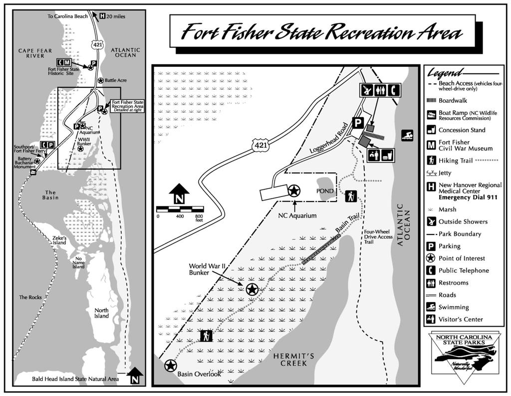
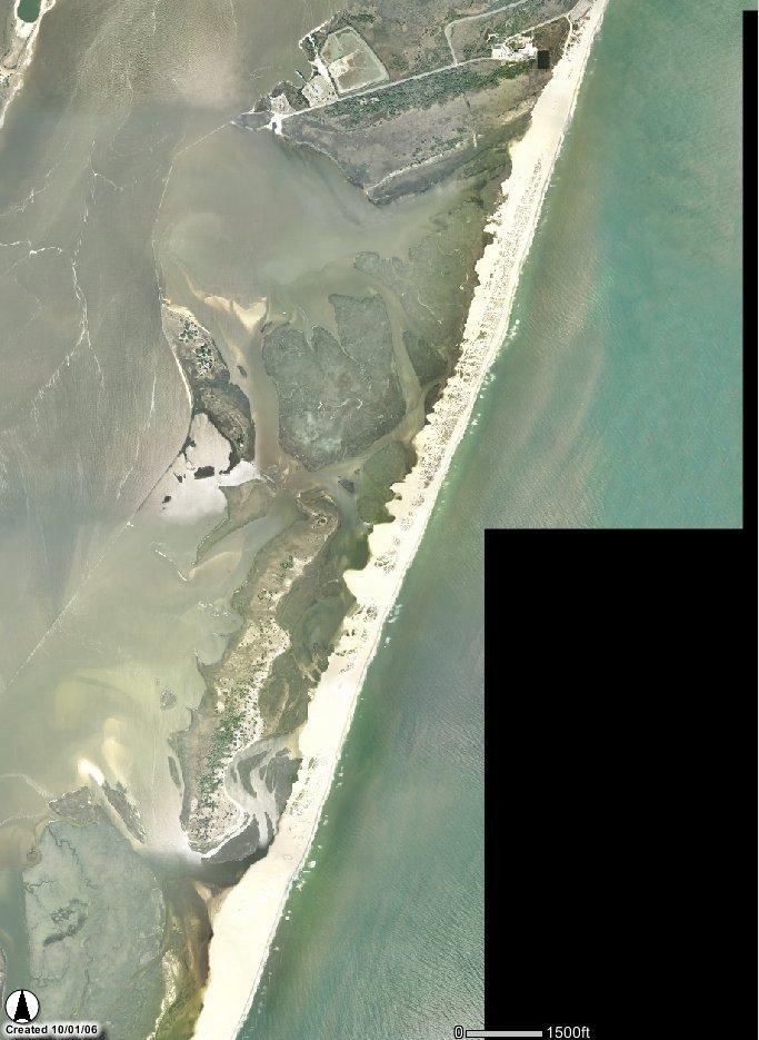
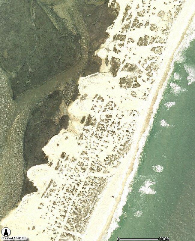
3 Your Assignment: A Limited VERP Plan for Fort Fisher State Recreation Area Despite the optimism surrounding the legislature s interest in resolving the conflict revolving around four-wheel-drive access and the Department of Environment and Natural Resources subsequent management policy, a defined, long-term management plan is needed. The public, elected officials and environmental agency staff have repeatedly called for progress in its development. Your assignment, therefore, is to develop a limited management plan for this area using VERP as the foundation. You are not restricted to developing this plan based upon the Department of Environment and Natural Resources recommendation. As a matter of fact, in examination of the literature, you may decide upon another course of action. Preparatory Research Examine the literature concerning the issues surrounding four-wheel-drive access at Fort Fisher State Recreation Area. Your plan should take into account the social, environmental, economic, institutional and legislative factors concerning the issue. Several important resources will be posted on my web site, however, you will probably need to secure additional material to complete your study. These can be found through a web and/or library search. And a visit to Fort Fisher State Recreation Area couldn t hurt either. The Written Document 1) Based upon your analysis of the Assessment of Ocean Beach Vehicular Use at Fort Fisher State Recreation Area explain and justify whether you agree with the Department of Environment and Natural Resource s recommendations for management of the area. Ensure that your analysis addresses the ecosystemic, political, economic and legislative aspects of the conflict and resultant recommendations. 2) Given the relevant information concerning four-wheel-drive access to Fort Fisher State Recreation Area: a) Define and describe an appropriate management zone for each of two areas: Zone 1- Oceanfront beach where four-wheel-access is allowed (east of the fourwheel-drive access trail, north to where the four-wheel-drive access trail turns to the beachfront and south to the border with Bald Head Island State Natural Area (see Fort Fisher State Recreation Area map) Zone 2- Vegetated dune areas scattered throughout the area west of oceanfront beach north to the pedestrian beachfront access trail and south to the border with Bald Head Island State Natural Area (see Fort Fisher State Recreation Area aerial photograph with zoomed example of scattered vegetated dunes) b) Develop a map delineating these zones (you may use either the supplied aerial photographs and maps or develop your own) c) Provide a written justification for each of these two zones based upon: purposes and significance range of desired visitor experiences intended resource conditions 3
4 resource constraints and sensitivities existing infrastructure 3) For each of the two zones you have identified: a) Develop an appropriate resource indicator based upon the following characteristics: Zone 1- turtle nesting Zone 2- dune vegetation b) Develop an appropriate standard (as a true VERP standard, not standard of quality ) for the resource indicator you have developed c) Develop an appropriate monitoring process for the above indicator/standard d) Develop appropriate management actions for the above indicator/standard e) Develop an appropriate social indicator based upon the following characteristics: Zone 1- vehicles Zone 2- dogs f) Develop an appropriate standard (as a true VERP standard, not standard of quality ) for the social indicator you have developed g) Develop an appropriate monitoring process for the above indicator/standard h) Develop appropriate management actions for the above indicator/standard Note that you will need to be creative and analytical in developing your plan. In creating your standards, use your best judgment in determining what an appropriate level might be (e.g. more than 10% loss of vegetation measured 5 feet from the edge of the fence line). It is important that you understand the concept, but not the specifics at this point. In developing your own VERP management plan for this area, examining the on-line sample VERP plan and Arches National Park VERP plan can give you some guidance. Due: Your written plan is due on November 25, Your grade will be based upon both the quality of your VERP plan and the professionalism of its written presentation (including formatting, spelling and grammar). 4
5 5
6
Order of the Minister of Environment #39, August 22, 2011 Tbilisi
 Registration Code 360050000.22.023.016080 Order of the Minister of Environment #39, August 22, 2011 Tbilisi On preparatory stages and procedure of the methodology for Elaborating structure, content and
DIRECTOR S ORDER #41: Wilderness Preservation and Management
 These are relevant sections about Wilderness Management Plans from National Park Service 2006 Management Policies, Director s Orders #41 and Reference Manual 41. National Park Service U.S. Department of
National Wilderness Steering Committee
 National Wilderness Steering Committee Guidance White Paper Number 1 Issue: Cultural Resources and Wilderness Date: November 30, 2002 Introduction to the Issue Two of the purposes of the National Wilderness
MARINE PROTECTED AREAS LESSON PLAN Water Parks
 Marine Protected Areas U. S. Marine Protected Areas Lesson Plan MARINE PROTECTED AREAS LESSON PLAN Water Parks Theme U.S. Marine Protected Areas Links to Overview Essays and Resources Needed for Student
Watchorn Provincial Park. Management Plan
 Watchorn Provincial Park Management Plan 2 Watchorn Provincial Park Table of Contents 1. Introduction... 3 2. Park History... 3 3. Park Attributes... 3 3.1 Natural... 4 3.2 Recreational... 4 3.3 Additional
Terrestrial Protected Area Nomination: Central Mangrove Wetland South-West, Grand Cayman
 Terrestrial Protected Area Nomination: Central Mangrove Wetland South-West, Grand Cayman The attached nomination, proposing that a parcel of land in the Central Mangrove Wetland be made a Protected Area
Access: The rocky shoreline is only accessible via private property.
 10. Whale Cove Site description: Whale Cove is a small cove fringed by private homes and condominiums with diverse and relatively undisturbed rocky intertidal and subtidal habitat located approximately
Decision Memo for Desolation Trail: Mill D to Desolation Lake Trail Relocation
 for Salt Lake County, Utah Uinta-Wasatch-Cache National Forest Salt Lake Ranger District 1. Background The present location of the Desolation Trail (#1159) between Mill D and Desolation Lake follows old
Procedure for the Use of Power-Driven Mobility Devices on Mass Audubon Sanctuaries 1 September 17, 2012
 Procedure for the Use of Power-Driven Mobility Devices on Mass Audubon Sanctuaries 1 September 17, 2012 Background As part of Mass Audubon s mission to preserve the nature of Massachusetts for people and
Thank you for this third opportunity to comment on the proposed revisions to the Coconino National Forest Management plan.
 March 19, 2014 Flagstaff Biking Organization PO Box 23851 Flagstaff, AZ 86002 Vern Keller Coconino National Forest Attn: Plan Revision 1824 South Thompson Street Flagstaff, Arizona 86001 coconino_national_forest_plan_revision_team@fs.fed.us
Tracy Ridge Shared Use Trails and Plan Amendment Project
 Tracy Ridge Shared Use Trails and Plan Amendment Project Scoping Document Forest Service Allegheny National Forest Bradford Ranger District McKean, County, Pennsylvania In accordance with Federal civil
REAUTHORISATION OF THE ALLIANCE BETWEEN AIR NEW ZEALAND AND CATHAY PACIFIC
 Chair Cabinet Economic Growth and Infrastructure Committee Office of the Minister of Transport REAUTHORISATION OF THE ALLIANCE BETWEEN AIR NEW ZEALAND AND CATHAY PACIFIC Proposal 1. I propose that the
FEASIBILITY CRITERIA
 This chapter describes the methodology and criteria used to evaluate the feasibility of developing trails throughout the study areas. Land availability, habitat sensitivity, roadway crossings and on-street
Department of Environment and Natural Resources
 Department of Environment and Natural Resources Brad Ives Assistant Secretary for Natural Resources brad.ives@ncdenr.gov 919-707-8620 Mitch Gillespie Assistant Secretary for Environment mitch.gillespie@ncdenr.gov
PROPOSED PARK ALTERNATIVES
 8 Chimne y Rock State Park M a ster Pl an 2011 PROPOSED PARK ALTERNATIVES Introduction Three different park development concepts were prepared and presented to the citizens of North Carolina through a
TRAILS WHERE TO FIND TRAILS IN NOVA SCOTIA
 TRAILs SIGNAGE Know the Signs............................ 44 WHERE YOU CAN RIDE Roads and Highways........................ 46 Designated Trails........................... 47 Established Trails...........................
Virginian Atlantic (Ecoregion 8)
") Virginian Atlantic (Ecoregion 8) Background The Virginian Atlantic Ecoregion extends from the south side of Cape Cod to Cape Hatteras in North Carolina. The waters of the ecoregion are a mix of cold and
Virginian Atlantic (Ecoregion 8) Background The Virginian Atlantic Ecoregion extends from the south side of Cape Cod to Cape Hatteras in North Carolina. The waters of the ecoregion are a mix of cold and
Comanche National Grassland, Timpas Unit
 Comanche National Grassland, Timpas Unit Heritage Resources More than 540 sites are eligible for listing on the National Register of Historic Places (NRHP) by Forest Service staff and/or the Colorado State
St. Christopher Camp and Conference Center s Outdoor education program for elementary and middle school students
 St. Christopher Camp and Conference Center s Outdoor education program for elementary and middle school students Since 1980, The Barrier Island Environmental Education Program has provided thousands of
Theme: Predominately natural/natural appearing; rustic improvements to protect resources. Size*: 2,500 + acres Infrastructure**:
 Recreation Opportunity Spectrum (ROS) Classes The Recreation Opportunity Spectrum (ROS) provides a way to describe the variations in the degree of isolation from the sounds and influences of people, and
Dungeness Recreation Area County Park Master Plan
 Dungeness Recreation Area County Park Public Outreach Meeting October 10, 2007 Project Overview USFWS Site Dungeness Recreation Area County Park Meeting Objectives: Re-Introduce project; provide status
National Park Service Wilderness Action Plan
 National Park Service U.S. Department of the Interior National Park Service Wilderness Action Plan National Wilderness Steering Committee National Park Service "The mountains can be reached in all seasons.
Worksheet: Resolving Trail Use(r) Conflict March 27, 2010
 Conflict March 27, 2010") RI Land & Water Summit Worksheet: Resolving Trail Use(r) Conflict March 27, 2010 John Monroe National Park Service, Rivers & Trails Program 617 223 5049 John_Monroe@nps.gov www.nps.gov/rtca In one sentence,
RI Land & Water Summit Worksheet: Resolving Trail Use(r) Conflict March 27, 2010 John Monroe National Park Service, Rivers & Trails Program 617 223 5049 John_Monroe@nps.gov www.nps.gov/rtca In one sentence,
Seek the Board s approval for the Donald Place kerb and channel renewal to progress to final design, tender and construction; and
 3. DONALD PLACE - KERB AND CHANNEL RENEWAL General Manager responsible: General Manager City Environment Officer responsible: Transport and City Streets Manager Author: Michelle Flanagan, Streets Capital
Labrador - Island Transmission Link Target Rare Plant Survey Locations
 27-28- Figure: 36 of 55 29-28- Figure: 37 of 55 29- Figure: 38 of 55 #* Figure: 39 of 55 30- - east side Figure: 40 of 55 31- Figure: 41 of 55 31- Figure: 42 of 55 32- - secondary Figure: 43 of 55 32-
Ecological Integrity and the Law
 FACULTY OF LAW Ecological Integrity and the Law Shaun Fluker Associate Professor of Law October 6, 2016 Ecological integrity issues are understood more as a matter of politics than ethics or law The judiciary
Site description: 2.7 miles of intertidal habitat located about 2 miles north of Depoe Bay in Lincoln County, Oregon (Figure 16).
.") 8 Boiler Bay Site description: 27 miles of intertidal habitat located about 2 miles north of Depoe Bay in Lincoln County, Oregon (Figure 16) Designation: Boiler Bay was a research reserve before TSP publication,
8 Boiler Bay Site description: 27 miles of intertidal habitat located about 2 miles north of Depoe Bay in Lincoln County, Oregon (Figure 16) Designation: Boiler Bay was a research reserve before TSP publication,
Proposed Action. Payette National Forest Over-Snow Grooming in Valley, Adams and Idaho Counties. United States Department of Agriculture
 United States Department of Agriculture Forest Service January 2012 Proposed Action Payette National Forest Over-Snow Grooming in Valley, Adams and Idaho Counties Payette National Forest Valley, Adams
Airports and UAS: Managing UAS Operations in the Airport Vicinity
 ACRP Problem Statement 17-10-09 Recommended Allocation: $350,000 Airports and UAS: Managing UAS Operations in the Airport Vicinity ACRP Staff Comments This is one of four UAS-themed problem statements
Terrestrial Protected Area Nomination: Hemmington Forest, Cayman Brac Central
 Terrestrial Protected Area Nomination: Hemmington Forest, Cayman Brac Central Initial discussions with major landowners in the Hemmington Forest area have indicated that a nomination to protect some or
Countries Of The World: Mexico
 Countries Of The World: Mexico By National Geographic Kids, adapted by Newsela staff on 06.07.18 Word Count 638 Level 800L Image 1: The pyramids of Guachimontones in Jalisco, Mexico. Mexico is a country
Marchand Provincial Park. Management Plan
 Marchand Provincial Park Management Plan 2 Marchand Provincial Park Table of Contents 1. Introduction... 3 2. Park History... 3 3. Park Attributes... 4 3.1 Natural... 4 3.2 Recreational... 4 3.3 Additional
Wilderness Research. in Alaska s National Parks. Scientists: Heading to the Alaska Wilderness? Introduction
 Wilderness Research in Alaska s National Parks National Park Service U.S. Department of Interior Scientists: Heading to the Alaska Wilderness? Archeologist conducts fieldwork in Gates of the Arctic National
PROUDLY BRINGING YOU CANADA AT ITS BEST. Management Planning Program NEWSLETTER #1 OCTOBER, 2000
 PROUDLY BRINGING YOU CANADA AT ITS BEST VUNTUT NATIONAL PARK Management Planning Program NEWSLETTER #1 OCTOBER, 2000 INTRODUCTION This newsletter launches the development of the first management plan for
DOWNLOAD OR READ : SOUTH AMERICA ENDANGERED ANIMALS PDF EBOOK EPUB MOBI
 DOWNLOAD OR READ : SOUTH AMERICA ENDANGERED ANIMALS PDF EBOOK EPUB MOBI Page 1 Page 2 south america endangered animals south america endangered animals pdf south america endangered animals South America
Sawtooth National Forest Fairfield Ranger District
 United States Department of Agriculture Forest Service Sawtooth National Forest Fairfield Ranger District P.O. Box 189 Fairfield, ID. 83327 208-764-3202 Fax: 208-764-3211 File Code: 1950/7700 Date: December
Cooperation Agreements for SAR Service and COSPAS-SARSAT SEARCH AND RESCUE AGREEMENTS: OVERVIEW. (Presented by United States)
") SAR/NAM/CAR/SAM IP/16 International Civil Aviation Organization 12/05/09 Search and Rescue (SAR) Meeting for the North American, Caribbean and South American Regions (SAR/NAM/CAR/SAM) (Puntarenas, Costa
SAR/NAM/CAR/SAM IP/16 International Civil Aviation Organization 12/05/09 Search and Rescue (SAR) Meeting for the North American, Caribbean and South American Regions (SAR/NAM/CAR/SAM) (Puntarenas, Costa
LINCOLNSHIRE PARKING POLICY DRAFT
 LINCOLNSHIRE PARKING POLICY DRAFT Draft 23/05/11 1 of 7 1. Introduction This document sets out and explains the County Councils Parking Policy. The County Council is planning to apply for powers to take
Continental Divide National Scenic Trail Legislative History and Planning Guidance
 Continental Divide National Scenic Trail Legislative History and Planning Guidance Legislation, Policy, and Direction Regarding National Scenic Trails The National Trails System Act, P.L. 90-543, was passed
Decision Memo Ice Age Trail Improvement (CRAC 37)
") Decision Memo Ice Age Trail Improvement (CRAC 37) U.S. Forest Service Chequamegon-Nicolet National Forest, Medford-Park Falls Ranger District Taylor County, Wisconsin T32N, R2W, Town of Grover, Section
Decision Memo Ice Age Trail Improvement (CRAC 37) U.S. Forest Service Chequamegon-Nicolet National Forest, Medford-Park Falls Ranger District Taylor County, Wisconsin T32N, R2W, Town of Grover, Section
Birch Point Provincial Park. Management Plan
 Birch Point Provincial Park Management Plan 2 Birch Point Provincial Park Table of Contents 1. Introduction... 3 2. Park History... 3 3. Park Attributes... 4 3.1 Natural... 4 3.2 Recreational... 4 4. Park
Daisy Dean Trail 628/619 ATV Trail Construction
 Background and Purpose and Need The Daisy Dean ATV Trail Construction Project is located in the Little Belt Mountains, Musselshell Ranger District, Lewis and Clark National Forest approximately 32 miles
Twelve Apostles Marine National Park Australia
 EVALUATION REPORT Twelve Apostles Marine National Park Australia Location: Victoria, Australia coastal waters Global Ocean Refuge Status: Nominated (2017), Evaluated (2017) MPAtlas.org ID: 7703885 Manager(s):
Sand Lakes Provincial Park. Draft Management Plan
 Sand Lakes Provincial Park Draft Management Plan 2 Sand Lakes Provincial Park Table of Contents 1. Introduction... 3 2. Background... 3 3. Park Purpose... 5 4. Park Management Guidelines... 6 Appendix...
MAIN LAKE PROVINCIAL PARK
 MAIN LAKE PROVINCIAL PARK PURPOSE STATEMENT AND ZONING PLAN March 2003 MAIN LAKE PROVINCIAL PARK Purpose Statement and Zoning Plan Primary Role The primary role of Main Lake Park is to protect a biologically
GENERAL ADVISORY CIRCULAR
 GENERAL CIVIL AVIATION AUTHORITY OF BOTSWANA ADVISORY CIRCULAR CAAB Document GAC-002 ACCEPTABLE FLIGHT SAFETY DOCUMENTS SYSTEM GAC-002 Revision: Original August 2012 PAGE 1 Intentionally left blank GAC-002
Title/Name of the area: Chwaka Bay, Zanzibar
 Title/Name of the area: Chwaka Bay, Zanzibar Presented by: Dr. Charles Lugomela, Ag. Head, Department of Aquatic Sciences and Fisheries, University of Dar es Salaam, P.O. Box 35064 Dar es Salaam, Tanzania
ECOTOURISM. Hill & Mountain Ecosystems
 ECOTOURISM Hill & Mountain Ecosystems Importance of Hill & Mountain Areas Home to most indigenous populations Provider of essential resources Major source of water supply Centres of culture and indigenous
KOALA BEACH ESTATE TWEED SHIRE. 20 Years On
 KOALA BEACH ESTATE TWEED SHIRE 20 Years On In the early 1990 s the Australian Koala Foundation (AKF) agreed to work with the Ray Group to create a model for koala-sensitive residential development at Koala
We, Ministers, assembled in Berlin for the International Conference on Biodiversity and Tourism from 6 to 8 March 1997
 March 8th, 1997 Berlin Declaration BIOLOGICAL DIVERSITY AND SUSTAINABLE TOURISM We, Ministers, assembled in Berlin for the International Conference on Biodiversity and Tourism from 6 to 8 March 1997 -
Countries Of The World: Mexico
 Countries Of The World: Mexico By National Geographic Kids, adapted by Newsela staff on 06.07.18 Word Count 659 Level MAX Image 1: The pyramids of Guachimontones in Jalisco, Mexico. Mexico is a country
Saadani National Park, Tanzania: Fostering Long Term Sustainability of Community Based Conservation and Development
 Saadani National Park, Tanzania: Fostering Long Term Sustainability of Community Based Conservation and Development Bruce Downie Kesho Trust, Tanzania; bdownie@thekeshotrust.org Key Messages Activities
South Colony Basin Recreation Fee Proposal
 South Colony Basin Recreation Fee Proposal Purpose and Need for Collecting Fees in South Colony Basin: Forest Service appropriated funds have not been sufficient to maintain current recreational services
D R O N E T R A C K E R. making your world possible
 D R O N E T R A C K E R 2 0 1 8 1 C O N T E N T S Background 3 Number of responses recreational vs commercial operators Profile of a recreational operator 5 Profile of a commercial operator 9 Business
That Council endorses the attached submission on the Reef 2050 Long-term Sustainability Plan.
 4 ORDINARY MEETING 22 OCTOBER 2014 1 REEF 2050 LONG-TERM SUSTAINABILITY PLAN D Walton 8/24/18-01 #4506842v2 RECOMMENDATION: That Council endorses the attached submission on the Reef 2050 Long-term Sustainability
LINCOLNSHIRE PARKING POLICY DRAFT
 LINCOLNSHIRE PARKING POLICY DRAFT Draft 17/11/11 1 of 7 1. Introduction This document sets out and explains the County Councils Parking Policy. The County Council is planning to apply for powers to take
Engineering With Nature Geographic Project Mapping Tool (EWN ProMap)
") Engineering With Nature Geographic Project Mapping Tool (EWN ProMap) Cynthia Banks Program Manager Burton Suedel, PhD Research Biologist Michelle Bourne Research Biologist U.S. Army ERDC 23 June 2015 Dredging
Engineering With Nature Geographic Project Mapping Tool (EWN ProMap) Cynthia Banks Program Manager Burton Suedel, PhD Research Biologist Michelle Bourne Research Biologist U.S. Army ERDC 23 June 2015 Dredging
NETWORK MANAGER - SISG SAFETY STUDY
 NETWORK MANAGER - SISG SAFETY STUDY "Runway Incursion Serious Incidents & Accidents - SAFMAP analysis of - data sample" Edition Number Edition Validity Date :. : APRIL 7 Runway Incursion Serious Incidents
VARGAS ISLAND PROVINCIAL PARK
 VARGAS ISLAND PROVINCIAL PARK PURPOSE STATEMENT AND ZONING PLAN February 2003 VARGAS ISLAND PROVINCIAL PARK Purpose Statement and Zoning Plan Primary Role The primary role of Vargas Island Park is to protect
WASHINGTON STATE PARKS AND RECREATION COMMISSION POLICY/PROCEDURE
 WASHINGTON STATE PARKS AND RECREATION COMMISSION POLICY/PROCEDURE 65-13-1 Use of Other Power-Driven Mobility Devices by Persons with Mobility Disabilities at State Park Facilities See Also: 28 CFR 35 Title
Ouimet Canyon Provincial Nature Reserve. Management Plan
 Ouimet Canyon Provincial Nature Reserve Management Plan NOTE: This document has been scanned and formatted, and therefore is slightly different from the original version. -March 2002 Additional copies
White Mountain National Forest Saco Ranger District
 United States Department of Agriculture Forest Service White Mountain National Forest Saco Ranger District 33 Kancamagus Highway Conway, NH 03818 Comm: (603) 447-5448 TTY: (603) 447-3121 File Code: 1950
Recreation Opportunity Spectrum for River Management v
 Recreation Opportunity Spectrum for Management v. 120803 Introduction The following Recreation Opportunity Spectrum (ROS) characterizations and matrices mirror the presentation in the ROS Primer and Field
Conservation Lands. Conservation Lands Advisory Committee October 19, 2005
 Conservation Lands Advisory Committee October 19, 2005 Roland DeBlois Chief of Environmental Planning & Code Enforcement Community Development Department Beth Powell Conservation Lands Manager Parks Division
REPORT 2014/111 INTERNAL AUDIT DIVISION. Audit of air operations in the United Nations Operation in Côte d Ivoire
 INTERNAL AUDIT DIVISION REPORT 2014/111 Audit of air operations in the United Nations Operation in Côte d Ivoire Overall results relating to the effective management of air operations in the United Nations
A GIS Analysis of Probable High Recreation Use Areas in Three Sisters Wilderness Deschutes and Willamette National Forests
 Lindsey Kiesz Geo 565 Term Project 3/15/2010 A GIS Analysis of Probable High Recreation Use Areas in Three Sisters Wilderness Deschutes and Willamette National Forests Introduction The Three Sisters Wilderness
LATIN AMERICA / CARIBBEAN COIBA NATIONAL PARK PANAMA
 LATIN AMERICA / CARIBBEAN COIBA NATIONAL PARK PANAMA WORLD HERITAGE NOMINATION IUCN TECHNICAL EVALUATION COIBA NATIONAL PARK (PANAMA) ID Nº 1138 Bis Background note: Coiba National Park was nominated for
JOB ANNOUNCEMENT P/T CAMP COUNSELOR PARKS AND RECREATION
 JOB ANNOUNCEMENT P/T CAMP COUNSELOR PARKS AND RECREATION Posting Date: January 12, 2017 Job Code: 033PT-CC-6100.00 Closing Date: Open Until Filled Grade: 0001 Non-Exempt Pay Range : Hourly: $9.00 Work
WORKING TOGETHER TO ENHANCE AIRPORT OPERATIONAL SAFETY. Ermenando Silva APEX, in Safety Manager ACI, World
 WORKING TOGETHER TO ENHANCE AIRPORT OPERATIONAL SAFETY Ermenando Silva APEX, in Safety Manager ACI, World Aerodrome Manual The aim and objectives of the aerodrome manual and how it is to be used by operating
STANDARDS MAP Basic Programs 1 and 2 English Language Arts Content Standards Grade Five
 : Pearson Program Title: Pearson California and Pearson California Components: : Teacher s Edition (TE), Student Edition (SE), Practice Book (PB); : Teacher s Edition (TE), Student Edition (SE), Transparencies
FINAL PROJECT COMPLETION REPORT
 FINAL PROJECT COMPLETION REPORT I. BASIC DATA Organization Name: Wildaid Project Title: Assessment and Strategy for Protecting Wildlife and Timber Resources in the Gunung Leuser Ecosystem II. OPENING REMARKS
DECISION MEMO. Rawhide Trail #7073 Maintenance and Reconstruction
 Page 1 of 6 Background DECISION MEMO USDA Forest Service Jefferson Ranger District Jefferson County, Montana Rawhide Trail #7073 is located in the Elkhorn Mountain Range approximately 10 miles east of
FLORIDA DEPARTMENT OF ENVIRONMENTAL PROTECTION DIVISION OF RECREATION AND PARKS RECREATIONAL CARRYING CAPACITY GUIDELINES
 FLORIDA DEPARTMENT OF ENVIRONMENTAL PROTECTION DIVISION OF RECREATION AND PARKS RECREATIONAL CARRYING CAPACITY GUIDELINES THE SELECTION AND CAPACITY DETERMINATION OF USE SITES Introduction The Division
What is an Marine Protected Area?
 Policies, Issues, and Implications of Marine Protected Areas Kara Anlauf University of Idaho Before the House Subcommittee on Fisheries Conservation, Wildlife and Oceans April 29, 2003 What is an Marine
Lake Myra County Park. Wake County, North Carolina Community Forum #2 June 12, 2008
 Lake Myra County Park Wake County, North Carolina Community Forum #2 June 12, 2008 Welcome and Introduction Meeting Agenda Welcome Introductions of Project Team Master Plan Process Community Forum #1 Updates
STUDY OVERVIEW MASTER PLAN GOALS AND OBJECTIVES
 INTRODUCTION An Airport Master Plan provides an evalua on of the airport s avia on demand and an overview of the systema c airport development that will best meet those demands. The Master Plan establishes
The Partnership Wild & Scenic Rivers Program
 BUDGET REQUEST FISCAL YEAR 2017 Proven, cost-effective protection for 770 miles of rivers and thousands of acres of riparian land Westfield River, MA (L) and Farmington River, CT (R) Partnership Wild &
MONTEREY REGIONAL AIRPORT MASTER PLAN TOPICAL QUESTIONS FROM THE PLANNING ADVISORY COMMITTEE AND TOPICAL RESPONSES
 MONTEREY REGIONAL AIRPORT MASTER PLAN TOPICAL QUESTIONS FROM THE PLANNING ADVISORY COMMITTEE AND TOPICAL RESPONSES Recurring topics emerged in some of the comments and questions raised by members of the
As outlined in the Tatshenshini-Alsek Park Management Agreement, park management will:
 Management Strategy General Strategy The priority management focus for the park is to ensure that its internationally significant natural, cultural heritage and recreational values are protected and that
Little River Trail Feasibility Study
 Final April, 2014 Prepared for the State Coastal Conservancy By the Natural Resources Services Division of Redwood Community Action Agency Table of Contents Executive Summary... 1 1. Project Purpose and
REVIEW OF THE STATE EXECUTIVE AIRCRAFT POOL
 STATE OF FLORIDA Report No. 95-05 James L. Carpenter Interim Director Office of Program Policy Analysis And Government Accountability September 14, 1995 REVIEW OF THE STATE EXECUTIVE AIRCRAFT POOL PURPOSE
COASTAL CONSERVANCY. Staff Recommendation June 5, 2008 GUALALA BLUFF TRAIL OPERATIONS AND MAINTENANCE
 COASTAL CONSERVANCY Staff Recommendation June 5, 2008 GUALALA BLUFF TRAIL OPERATIONS AND MAINTENANCE File No. 08-047-01 Project Manager: Deborah Hirst RECOMMENDED ACTION: Consideration and possible Conservancy
Kelly Motorized Trails Project Proposed Action
 Kelly Motorized Trails Project Proposed Action November 28, 2011 The Flagstaff Ranger District of the Coconino National Forest is seeking public input on the proposed Kelly Motorized Trails Project (formerly
TOWARDS SUSTAINABLE MANAGEMENT OF MARINE AND COASTAL HABITATS ASIA- PACIFIC DAY FOR THE OCEAN
 TOWARDS SUSTAINABLE MANAGEMENT OF MARINE AND COASTAL HABITATS WANNAKIAT THUBTHIMSANG PHUKET MARINE BIOLOGICAL CENTER, DMCR, THAILAND ASIA- PACIFIC DAY FOR THE OCEAN 20 NOVEMBER 2018, CONFERENCE ROOM 4,
THAT the Board approve the final proposed concept plan for the Jericho Marginal Wharf site as shown in Figure C-4 of Appendix C.
 Date: January 17, 2012 TO: Board Members Vancouver Park Board FROM: General Manager Parks and Recreation SUBJECT: Jericho Marginal Wharf Phase 2 Concept Plan RECOMMENDATION THAT the Board approve the final
Beaver Creek Provincial Park. Management Plan
 Beaver Creek Provincial Park Management Plan 2 Beaver Creek Provincial Park Table of Contents 1. Introduction... 3 2. Park History... 3 3. Park Attributes... 4 3.1 Natural... 4 3.2 Recreational... 4 4.
Biodiversity is life Biodiversity is our life
 Biodiversity is life Biodiversity is our life Chapter 10 Section 2 Biodiversity at Risk Objectives Define and give examples of endangered and threatened species. Describe several ways that species are
PUBLIC OPINION RESEARCH SURVEY RESULTS
 PUBLIC OPINION RESEARCH SURVEY RESULTS www.floridaopinionresearch.com All Materials and Intellectual Property 2015 Florida Opinion Research @FlaOpinResearch 1 Telephone interviews performed by specially-trained
BSc (Hons) Food Science and Technology (Minor: Food Microbiology) (Full-Time)
 Food Science and Technology (Minor: Food Microbiology) (Full-Time)") BSc (Hons) Food Science and Technology (Minor: Food Microbiology) (Full-Time) 1. Objectives The programme is designed to develop the necessary attitude and competence for the application of scientific
BSc (Hons) Food Science and Technology (Minor: Food Microbiology) (Full-Time) 1. Objectives The programme is designed to develop the necessary attitude and competence for the application of scientific
Norman Y. Mineta San José International Airport 2017 Annual Noise Report
 Norman Y. Mineta San José International Airport 2017 Annual Noise Report Annual Noise Report for Norman Y. Mineta San José International Airport Introduction and Purpose The purpose of this annual report
Land Management Summary
 photo credit: ANGAIR Anglesea Heath Land Management Summary The Anglesea Heath (6,501 ha) was incorporated into the Great Otway National Park in January 2018. This provides an opportunity to consider the
Exemplar for Internal Achievement Standard Geography Level 1. Conduct geographic research, with direction
 Exemplar for internal assessment resource Geography for Achievement Standard 91011 Exemplar for Internal Achievement Standard Geography Level 1 This exemplar supports assessment against: Achievement Standard
A summary of Draft Makara Peak Mountain Bike Park Master Plan
 A summary of Draft Makara Peak Mountain Bike Park Master Plan OVEMBER 216 Image: Peter Marshall 2 3 Introduction Since it was established in 1998, the Makara Peak Mountain Bike Park (Makara Peak) has grown
WORLDWIDE AIR TRANSPORT CONFERENCE: CHALLENGES AND OPPORTUNITIES OF LIBERALIZATION. Montreal, 24 to 29 March 2003
 26/2/03 English only WORLDWIDE AIR TRANSPORT CONFERENCE: CHALLENGES AND OPPORTUNITIES OF LIBERALIZATION Montreal, 24 to 29 March 2003 Agenda Item 1: Preview 1.1: Background to and experience of liberalization
BURGES JAMES GADSDEN PROVINCIAL PARK PURPOSE STATEMENT AND ZONING PLAN
 BURGES JAMES GADSDEN PROVINCIAL PARK PURPOSE STATEMENT AND ZONING PLAN February 2003 BURGES JAMES GADSDEN PROVINCIAL PARK Purpose Statement and Zoning Plan Primary Role The primary role of Burges James
STREAKED HORNED LARK. Conservation of a threatened species in an industrial landscape. Cat Brown US Fish and Wildlife Service
 STREAKED HORNED LARK Conservation of a threatened species in an industrial landscape Cat Brown US Fish and Wildlife Service HISTORICAL & CURRENT RANGE Streaked Horned Lark Distribution Historical Range:
Committee. Presentation Outline
 CW-33-15 11/9/2015 Community and Corporate Services Committee November 10, 2015 1 Presentation Outline Background Vision and Objectives Study Process and Timeline Public and Stakeholder Engagement Organization
Thank you for this second opportunity to comment on the proposed revisions to the Coconino National Forest Management plan.
 March 8, 2011 Flagstaff Biking Organization PO Box 23851 Flagstaff, AZ 86002 Yewah Lau Coconino National Forest Attn: Plan Revision 1824 South Thompson Street Flagstaff, Arizona 86001 Sent via electronic
NATIONAL AIRSPACE POLICY OF NEW ZEALAND
 NATIONAL AIRSPACE POLICY OF NEW ZEALAND APRIL 2012 FOREWORD TO NATIONAL AIRSPACE POLICY STATEMENT When the government issued Connecting New Zealand, its policy direction for transport in August 2011, one
Malua Biobank Operations Report. Submitted by the Sabah Forestry Department May June 2009
 Malua Biobank Operations Report Submitted by the Sabah Forestry Department May 2009 - June 2009 Protection Boundary monitoring and patrol, gate installations, signage installation and maintenance, night