2015 Brain Wrinkles. SS8G1b
|
|
|
- Jane Cain
- 6 years ago
- Views:
Transcription


1 SS8G1b
2 Standards SS8G1 The student will describe Georgia with regard to physical features and location. b. Describe the five geographic regions of Georgia; include the Blue Ridge Mountains, Valley and Ridge, Appalachian Plateau, Piedmont, and Coastal Plain.
3 Teacher Directions CLOZE Notes The next pages are handouts for the students to use for note-taking during the presentation. (Print front to back to save paper and ink.) Check the answers as a class after the presentation.
4 Five Regions Georgia is a geographically diverse state that is divided into. The first three regions (Appalachian Plateau, Valley and Ridge, and Blue Ridge) are in the of the state and form part of the Appalachian Mountain range. The other two (Piedmont and Coastal Plain) include, as well as some of the in the middle of the state. Appalachian Plateau The Appalachian Plateau is the state s. It s located in the very of Georgia and encompasses Dade County. The region features a with Sand Mountain on one side and Lookout Mountain on the other. The region contains two waterfalls, many underground caves, and it is. The average summer temperature is 70 degrees, and the average winter temperature is just above. It is not a good area for farming because of the sandy soil; however, it was once a profitable area for. Blue Ridge The Blue Ridge region is in the of Georgia, and it is made up of the Blue Ridge Mountains. This area contains the southern point of the (which run up to Maine). The region is also home to Georgia s highest peak, (4,784 feet). The tallest waterfall east of the Mississippi River,, is in this region. Also,, which is two miles long and 1,000 feet deep, is located here. The area attracts each year due to its beautiful scenery and outdoor activities. Aside from apples, grapes, and some vegetables, is grown here. The Blue Ridge region receives the in Georgia. The average summer temperature is, while the average winter temperature is 45 degrees Brain Wrinkles

5 Valley & Ridge The Valley and Ridge region is located in, east of the Appalachian Plateau. The region consists of several and the valleys between them. The elevation of the region ranges from. The region s region, with slightly less rainfall. are the region s main industries. The and agricultural products include corn, soybeans, wheat, cotton, and apples. are raised on pastures in the valleys. Piedmont The Piedmont region is in the of Georgia, and makes up roughly 30% of the state s land area. The name means foot of the mountains, as it is made up of that slope towards the south. The elevation ranges from 500 feet at its southern border ( ) to 1700 feet at its northern border. The Piedmont region has large amounts of, enabling Georgia to be the nation s leading producer of both. It is also known for its, which is rich in iron minerals. The region is, with large amounts of corn, peaches, wheat, soybeans, cattle, and poultry being produced. Nearly lives in this region, thanks to cities like Atlanta, Athens, Macon, Columbus, Augusta, and Milledgeville. There are in this region, and it features the bulk of Georgia s industry. Coastal Plain The Coastal Plain is the largest region, covering roughly. It begins at the Fall Line and extends to Georgia s. It stretches from the off of Georgia s eastern coast to Alabama. The Coastal Plain has and produces the majority of the state s crops., and other agricultural products are grown here. The region has, which attracts large numbers of tourists each year. The Coastal Plain and Piedmont regions are more than the other regions because they are between the warm waters of the Gulf of Mexico and the Atlantic Ocean. Summer tends to be, while the winter is mild compared to the rest of the country Brain Wrinkles
6 Five Regions Georgia is a geographically diverse state that is divided into five regions. The first three regions (Appalachian Plateau, Valley and Ridge, and Blue Ridge) are in the mountains and foothills of the state and form part of the Appalachian Mountain range. The other two (Piedmont and Coastal Plain) include coastal and farming areas, as well as some of the large cities in the middle of the state. Appalachian Plateau The Appalachian Plateau is the state s smallest region. It s located in the very northwest corner of Georgia and encompasses Dade County. The region features a long, narrow valley with Sand Mountain on one side and Lookout Mountain on the other. The region contains two waterfalls, many underground caves, and it is covered in forests. The average summer temperature is 70 degrees, and the average winter temperature is just above 40 degrees. It is not a good area for farming because of the sandy soil; however, it was once a profitable area for mining coal and iron ore. Blue Ridge The Blue Ridge region is in the northeast corner of Georgia, and it is made up of the Blue Ridge Mountains. This area contains the southern point of the Appalachian Mountains (which run up to Maine). The region is also home to Georgia s highest peak, Brasstown Bald (4,784 feet). The tallest waterfall east of the Mississippi River, Amicalola Falls, is in this region. Also, Tallulah Gorge, which is two miles long and 1,000 feet deep, is located here. The area attracts thousands of tourists each year due to its beautiful scenery and outdoor activities. Aside from apples, grapes, and some vegetables, not much agriculture is grown here. The Blue Ridge region receives the most rainfall in Georgia. The average summer temperature is 69 degrees, while the average winter temperature is 45 degrees Brain Wrinkles
7 Valley & Ridge The Valley and Ridge region is located in northwest Georgia, east of the Appalachian Plateau. The region consists of several high, narrow mountain ridges and the valleys between them. The elevation of the region ranges from 700 to 1,600 feet. The region s climate is similar to the Blue Ridge region, with slightly less rainfall. Mining and farming are the region s main industries. The soil is rich and agricultural products include corn, soybeans, wheat, cotton, and apples. Beef cattle are raised on pastures in the valleys. Piedmont The Piedmont region is in the central area of Georgia, and makes up roughly 30% of the state s land area. The name means foot of the mountains, as it is made up of low rolling hills that slope towards the south. The elevation ranges from 500 feet at its southern border (called the Fall Line) to 1700 feet at its northern border. The Piedmont region has large amounts of granite and marble, enabling Georgia to be the nation s leading producer of both. It is also known for its red clay, which is rich in iron minerals. The region is important for agriculture, with large amounts of corn, peaches, wheat, soybeans, cattle, and poultry being produced. Nearly 50% of Georgia s population lives in this region, thanks to cities like Atlanta, Athens, Macon, Columbus, Augusta, and Milledgeville. There are a lot of businesses in this region, and it features the bulk of Georgia s industry. Coastal Plain The Coastal Plain is the largest region, covering roughly 60% of the state. It begins at the Fall Line and extends to Georgia s southern border with Florida. It stretches from the barrier islands off of Georgia s eastern coast to Alabama. The Coastal Plain has good farmland and produces the majority of the state s crops. Peanuts, onions, pecans, corn, and other agricultural products are grown here. The region has 100 miles of coast, which attracts large numbers of tourists each year. The Coastal Plain and Piedmont regions are more humid and tropical than the other regions because they are between the warm waters of the Gulf of Mexico and the Atlantic Ocean. Summer tends to be long and hot, while the winter is mild compared to the rest of the country Brain Wrinkles
8 2014 Brain Wrinkles Teacher Directions - Chart Print the Georgia s Regions graphic organizer for each student. Students will complete the graphic organizer while discussing the presentation. Check answers as a class at the end of the presentation to be sure that all charts are completed correctly.
9 Directions: Complete the chart below while discussing the presentation. Appalachian Plateau Location Climate Resources Features & Facts Blue Ridge Valley & Ridge Piedmont Coastal Plain
 Summer 70 degrees Winter 40 degrees Not good for farming; past = coal and iron ore Smallest")
10 Directions: Complete the chart below while discussing the presentation. Location Climate Resources Features & Facts Appalachian Plateau Northwest corner of GA (Dade County) Summer 70 degrees Winter 40 degrees Not good for farming; past = coal and iron ore Smallest region; Sand Mountain & Lookout Mountain are here; Blue Ridge Northeast corner of GA; southern part of Appalachian Mountains Receives most rainfall; summer 69 degrees; winter 45 degrees Scenery and outdoor activities attract tourists ; not much agriculture other than apples, grapes, & some veggies Contains Blue Ridge Mountains; Brasstown Bald GA s highest point; Amicalola Falls (highest waterfall east of Mississippi); Tallulah Gorge Valley & Ridge Northwest Georgia; east of Appalachian Plateau Same as Blue Ridge less rainfall Mining, farming (corn, soybeans, wheat, cotton, apples, etc.), and beef cattle High, narrow mountain ridges with valleys between; elevation between 700 to 1600 feet Piedmont Central region of GA; 30% of land area Similar to Coastal Plain Granite, marble, red clay Important region for agriculture (corn, peaches, wheat, soybeans, cattle, poultry) Low rolling hills; 50% of population lives here; lots of industry Coastal Plain Largest region (60% of state); begins at Fall Line to Florida, and from east coast to Alabama More humid and tropical; long, hot summers and mild winters Good farmland = majority of state s crops (peanuts, onions, pecans, onions, etc.); tourism 100 miles of coast; barrier islands are here

11 SS8G1b
 are in the")
 include coastal and farming areas, as well as some of")
12 Georgia is a geographically diverse state that is divided into five regions. The first three regions (Appalachian Plateau, Valley and Ridge, and Blue Ridge) are in the mountains and foothills of the state and form part of the Appalachian Mountain range. The other two (Piedmont and Coastal Plain) include coastal and farming areas, as well as some of the large cities in the middle of the state.
13 Appalachian Plateau Valley & Ridge Blue Ridge Piedmont Coastal Plain
14 The Appalachian Plateau is the state s smallest region. It s located in the very northwest corner of Georgia and encompasses Dade County. The region features a long, narrow valley with Sand Mountain on one side and Lookout Mountain on the other.
15 Appalachian Plateau

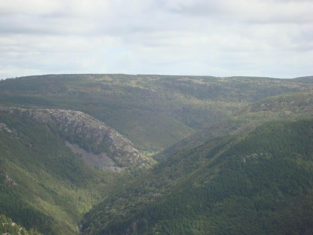
16 View from Lookout Mountain
17 The region contains two waterfalls, many underground caves, and it is covered in forests. The average summer temperature is 70 degrees, and the average winter temperature is just above 40 degrees. It is not a good area for farming because of the sandy soil; however, it was once a profitable area for mining coal and iron ore.
18
19 The Blue Ridge region is in the northeast corner of Georgia, and it is made up of the Blue Ridge Mountains. This area contains the southern point of the Appalachian Mountains (which run up to Maine). The region is also home to Georgia s highest peak, Brasstown Bald (4,784 feet).
20 Blue Ridge

21 Brasstown Bald
22 The tallest waterfall east of the Mississippi River, Amicalola Falls, is in this region. Also, Tallulah Gorge, which is two miles long and 1,000 feet deep, is located here. The area attracts thousands of tourists each year due to its beautiful scenery and outdoor activities. Aside from apples, grapes, and some vegetables, not much agriculture is grown here.


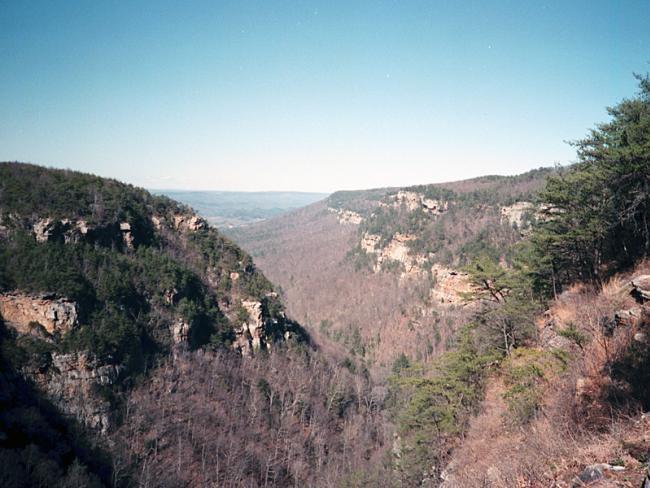
23 Amicalola Falls Tallulah Gorge

24 The Blue Ridge region receives the most rainfall in Georgia. The average summer temperature is 69 degrees, while the average winter temperature is 45 degrees.

25
26 The Valley and Ridge region is located in northwest Georgia, east of the Appalachian Plateau. The region consists of several high, narrow mountain ridges and the valleys between them. The elevation of the region ranges from 700 to 1,600 feet. The region s climate is similar to the Blue Ridge region, with slightly less rainfall.
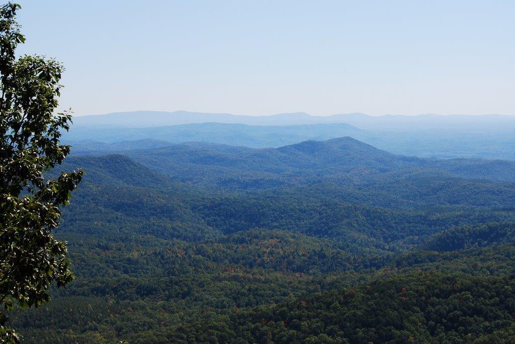
27 Valley & Ridge
28

29 Mining and farming are the region s main industries. The soil is rich and agricultural products include corn, soybeans, wheat, cotton, and apples. Beef cattle are raised on pastures in the valleys.


30
31 The Piedmont region is in the central area of Georgia, and makes up roughly 30% of the state s land area. The name means foot of the mountains, as it is made up of low rolling hills that slope towards the south. The elevation ranges from 500 feet at its southern border (called the Fall Line) to 1700 feet at its northern border.
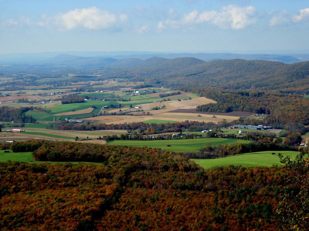
32 Piedmont


33 Athens, GA
34 The Piedmont region has large amounts of granite and marble, enabling Georgia to be the nation s leading producer of both. It is also known for its red clay, which is rich in iron minerals. The region is important for agriculture, with large amounts of corn, peaches, wheat, soybeans, cattle, and poultry being produced.


35 Georgia s Red Clay Granite Quarry in Georgia

36 Nearly 50% of Georgia s population lives in this region, thanks to cities like Atlanta, Athens, Macon, Columbus, Augusta, and Milledgeville. There are a lot of businesses in this region, and it features the bulk of Georgia s industry.


37 Atlanta
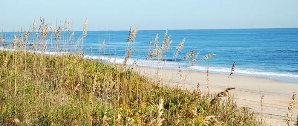
38 The Coastal Plain is the largest region, covering roughly 60% of the state. It begins at the Fall Line and extends to Georgia s southern border with Florida. It stretches from the barrier islands off of Georgia s eastern coast to Alabama.

39 Coastal Plain

40 Vidalia Onions
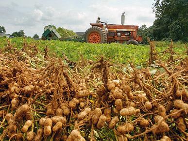
41 The Coastal Plain has good farmland and produces the majority of the state s crops. Peanuts, onions, pecans, corn, and other agricultural products are grown here. The region has 100 miles of coast, which attracts large numbers of tourists each year.
42

43 The Coastal Plain and Piedmont regions are more humid and tropical than the other regions because they are between the warm waters of the Gulf of Mexico and the Atlantic Ocean. Summer tends to be long and hot, while the winter is mild compared to the rest of the country.

44 Teacher Info Georgia s Regions Map Print off the Georgia s Regions map for each student. The students will label and color the 5 regions on the map.
45 Georgia s 5 Regions Directions: Label the following regions on the map. Please use different colors for each region Brain Wrinkles
46 Teacher Info Real Estate Ad Have the students choose one of the five regions and create an advertisement for land that is available to settle within that region. They will write a testimonial statement that promotes the land, as well as brief descriptions of climate, land features, and resources in the region. They will also need to include illustrations for each section.

47 Testimonial: Climate Land _ Resources _
48 Teacher Info Billboard Have the students choose one of the five regions and create a welcome sign that visitors will see as they enter the region. The sign should include key facts about the region, as well as illustrations.
49 Directions: Choose one of Georgia s five regions and create a welcome sign that visitors will see as they enter the region. The sign should include key facts about the region, as well as significant illustrations Brain Wrinkles
50 2014 Brain Wrinkles Teacher Info Pass the Paper Put the students into small groups (you will need 5 groups total). Print off the white Regions slides and give one paper to each group. Give each group about 30 seconds to write down everything the know about the region but they can t write something that is already written. (They can also draw pictures or symbols.) When time is up, they must pass the paper to the next group. This continues until every group has worked with each of the 5 papers. Have each group share the paper & discuss the information.

51 With your group, you will have 30 seconds to write or draw everything that you know about the region on your paper. Every group member must participate angle yourselves so that you can all write at the same time. The catch is that you cannot write or draw something that is already written! When I say that time is up, you must pass the paper on to the next group. We will continue to Pass the Paper until each group has seen all of papers.

52 Appalachian Plateau
53 Blue Ridge
54 Valley & Ridge
55 Piedmont
56 Coastal Plain
57 Brain Wrinkles Teacher Info Ticket Out the Door Snapchat Have the students create a snapchat message for one of the geographic regions from the lesson. The message should include an illustration that represents the region, as well as text to describe it. *There are two-per-page.


58 Name: Name: Create a snapchat about one of Georgia s five regions. Include a visual and text to describe the region. Create a snapchat about one of Georgia s five regions. Include a visual and text to describe the region. To: From: To: From: Text: Text: Brain Wrinkles Brain Wrinkles


59 Thank you so much for downloading this file. I sincerely hope you find it helpful and that your students learn a lot from it! I look forward to reading your feedback in my store. If you like this file, you might want to check out some of my other products that teach social studies topics in creative, engaging, and hands-on ways. Best of luck to you this school year, Ansley at Brain Wrinkles 2015 Brain Wrinkles


60 2015 Brain Wrinkles. Your download includes a limited use license from Brain Wrinkles. The purchaser may use the resource for personal classroom use only. The license is not transferable to another person. Other teachers should purchase their own license through my store. This resource is not to be used: By an entire grade level, school, or district without purchasing the proper number of licenses. For school/district licenses at a discount, please contact me. As part of a product listed for sale or for free by another individual. On shared databases. Online in any way other than on password-protected website for student use only. Copyright Brain Wrinkles. All rights reserved. Permission is granted to copy pages specifically designed for student or teacher use by the original purchaser or licensee. The reproduction of any other part of this product is strictly prohibited. Copying any part of this product and placing it on the Internet in any form (even a personal/classroom website) is strictly forbidden. Doing so makes it possible for an Internet search to make the document available on the Internet, free of charge, and is a violation of the Digital Millennium Copyright Act (DMCA). Thank you, Ansley at Brain Wrinkles Clipart, fonts, & digital papers for this product were purchased from:
SS8G1 The student will describe Georgia with regard to physical features and location.
 SS8G1ab Standards SS8G1 The student will describe Georgia with regard to physical features and location. a. Locate Georgia in relation to the region, nation, continent, and hemispheres. b. Describe the
2015 Brain Wrinkles. SS8G1b
 SS8G1b Georgia is a geographically diverse state that is divided into five regions. The first three regions (Appalachian Plateau, Valley and Ridge, and Blue Ridge) are in the mountains and foothills of
2014 Brain Wrinkles. SS8H2a. Creating a
 SS8H2a Creating a in Standards SS8H2 The student will analyze the colonial period of Georgia s history. a. Explain the importance of James Oglethorpe, the Charter of 1732, reasons for settlement (charity,
Africa s. Presentation, Graphic Organizers, & Activities
 Africa s Presentation, Graphic Organizers, & Activities STANDARDS: SS7G1 Locate selected features of Africa. a. Locate on a world and regional political-physical map: Sahara, Sahel, savanna, tropical rain
Location, Climate, & Natural Resources. Where People Live & How They Trade
 Location, Climate, & Natural Resources Where People Live & How They Trade Standards SS6G13 The student will explain the impact of location, climate, distribution of natural resources, and population distribution
Georgia s Brain Wrinkles. SS8G1c
 Georgia s 2015 Brain Wrinkles SS8G1c There are many different physical features in the state of Georgia. Physical features include bodies of water, deserts, mountain ranges, and other landforms. They are
student. They should complete the
 Standards SS6H3 The student will analyze important 20th century issues in Latin America and the Caribbean. a. Explain the impact of the Cuban Revolution. Teachers Print off the following page for each
4th Grade Social Studies 2nd Nine Weeks Test
 4th Grade Social Studies 2nd Nine Weeks Test Multiple Choice Identify the choice that best completes the statement or answers the question. 1 Which is the largest city in the United States? A Philadelphia,
Student Reading 13.10: The Regions of Ohio
 Student Reading 13.10: The Regions of Ohio Ohio has five natural regions which formed more than 10,000 years ago. A natural region is an area that shares the same natural features. These places have similar
Location, Climate, & Natural Resources Brain Wrinkles
 Location, Climate, & Natural Resources Standards SS6G10 The student will explain the impact of location, climate, natural resources, and population distribution on Europe. a. Compare how the location,
LOCATION, CLIMATE, AND NATURAL RESOURCES OF MEXICO
 SS6G3 The student will explain the impact of location, climate, distribution of natural resources, and population distribution on Latin America and the Caribbean. a. Compare how the location, climate,
SS6H3 The student will analyze important 20th century issues in Latin America and the Caribbean.
 Standards SS6H3 The student will analyze important 20th century issues in Latin America and the Caribbean. a. Explain the impact of the Cuban Revolution. Where is Cuba? Cuba gained its independence from
STANDARDS: Brain Wrinkles
 STANDARDS: SS6G3 The student will explain the impact of location, climate, distribution of natural resources, and population distribution on Latin America and the Caribbean. a. Compare how the location,
LOCATION, LOCATION, LOCATION! Mexico, Venezuela, Cuba, and Brazil
 LOCATION, LOCATION, LOCATION! Mexico, Venezuela, Cuba, and Brazil GPS and E.Q. GPS: SS6G3 The student will explain the impact of location, climate, distribution of natural resources, and population distribution
Brain Wrinkles. Location, Climate, & Natural Resources of. Where People Live & How They Trade
 Location, Climate, & Natural Resources of Where People Live & How They Trade It s south of the US, east of the Pacific Ocean, and west of the Gulf of Mexico & Caribbean Sea. It s great that it s located
Brain Wrinkles. Africa: The impact of location, climate, & physical characteristics on where people live, the type of work they do, & how they travel
 Africa: The impact of location, climate, & physical characteristics on where people live, the type of work they do, & how they travel STANDARDS: SS7G3 The student will explain the impact of location, climate,
Geography: Unit 2. Map. Rivers. Major Physical Features. Slide 1. Slide 2. Slide 3. Slide 4. North America United States and Canada.
 Mississippi River Slide 1 Slide 2 Slide 3 Slide 4 Geography: Unit 2 North America United States Map Major Physical Features Mountain Ranges Brooks Range Mackenzie Mountains Coast Mountains Cascades Sierra
What Is An Ecoregion?
 Ecoregions of Texas What Is An Ecoregion? Ecoregion a major ecosystem with distinctive geography, characteristic plants and animals, and ecosystems that receives uniform solar radiation and moisture Sometimes
The Land Photo Source: The Atlas of Canada, The Red River, Manatoba, Canada land/physio_red_ri
 The Land The United States and Canada An Overview of the Region The United States and Canada are the two largest countries in North America. The Rio Grande is part of the southwest border of the United
There are actually six geographic sub-regions, three in both the uplands and the lowlands.
 6 Regions of AR Although Arkansas is most easily divided into two distinct geographical regions, the northwestern uplands and the southeastern lowlands, this description does not accurately portray the
OKLAHOMA HISTORY OKLAHOMA S GEOGRAPHY
 OKLAHOMA HISTORY OKLAHOMA S GEOGRAPHY BOARD QUESTIONS 1) HOW BIG IS OKLAHOMA? 2) HOW MANY COUNTIES ARE IN OKLAHOMA? 3) HOW FAR IS IT FROM OKC TO LAS ANGLES, CALIFORNIA? 4) HOW MANY STATE BORDER OKLAHOMA?
Location, Climate, & Natural Resources
 Location, Climate, & Natural Resources UK is a country of islands off the coast of mainland Europe. It consists of England, Northern Ireland, Scotland, & Wales. UK s location makes it a HUB for trade.
Chapter 20. The Physical Geography of Africa South of the Sahara
 Chapter 20 The Physical Geography of Africa South of the Sahara Chapter Objectives Identify the major landforms, water systems, and natural resources of Africa south of the Sahara. Describe the relationship
Geography: Unit 2. Map. Major Physical Features. Rivers. Mississippi River Missouri River Ohio River Rio Grande. Mackenzie. Colorado River Green River
 1 2 3 4 Geography: Unit 2 North America United States and Canada Map Major Physical Features Mountain Ranges Brooks Range Mackenzie Mountains Coast Mountains Cascades Sierra Nevada Rocky Mountains Appalachian
Region 1 Piney Woods
 Region 1 Piney Woods Piney Woods 1. This ecoregion is found in East Texas. 2. Climate: average annual rainfall of 36 to 50 inches is fairly uniformly distributed throughout the year, and humidity and temperatures
Latin America and The Caribbean. A Closer Look.
 Latin America and The Caribbean A Closer Look. Mexico Capital: Mexico City The Location of Mexico Mexico is the second-largest country by size and population in Latin America.but the Largest Spanish -
Essential Questions. 1. How have historical figures and events affected South America today?
 South America Essential Questions 1. How have historical figures and events affected South America today? 2. How has location affected the development of countries in South America? 3. How has the role
Economy 3. This region s economy was based on agriculture. 4. This region produced items such as textiles, iron, and ships in great quantities. For th
 Geography 1. This region has a climate of warm summers and snowy cold winters. 2. This region has a climate that is generally warm and sunny, with long, hot, humid summers, and mild winters, and heavy
SOL VS.2a, 2b, 2c, 10b
 What are the characteristics of the Coastal Plain? 1. Also known as Tidewater 2. Located near the Atlantic Ocean and the Chesapeake Bay 3. Includes the Eastern Shore, a peninsula between the Atlantic Ocean
Hungry 4 History Trivia VA Studies 2010 and beyond
 Hungry 4 History Trivia VA Studies 2010 and beyond Level 1 1 What may be described using terms that show connections between two places such as: next to, near, or bordering? 2 3 What two large bodies of
STUDY GUIDE. The Land. Physical Features of Latin America. Chapter 8, Section 1. Terms to Know DRAWING FROM EXPERIENCE ORGANIZING YOUR THOUGHTS
 For use with textbook pages 193 198. The Land Terms to Know cordillera A mountain range that runs parallel to another mountain range (page 194) altiplano A high plain (page 194) escarpment A steep cliff
Introduction to Africa
 Introduction to Africa Did you know? Africa has more countries than any other continent. The Sahara is a desert that is the size of the U.S. It s the world's largest desert. Most of the world s gold and
Latin America. Chapter 9 Physical Geography
 Latin America Chapter 9 Physical Geography Latin American Regions Middle America includes Mexico and the Central American countries The Caribbean Islands South America Mexico Landforms Sierra Madre Oriental
The Geological Pacific Northwest. Wednesday February 6, 2012 Pacific Northwest History Mr. Rice
 The Geological Pacific Northwest Wednesday February 6, 2012 Pacific Northwest History Mr. Rice 1 Free Response #2 Please do not simply list the items for this response. Full sentences!!! Minimum of 3-5
Friday, November 10, 2017
 Friday, November 10, 2017 Andes and Midlatitude Countries Objective: Summarize the main physical features and regions of the Southern Cone. Identify and locate the urban centers and understand the pattern
Mexico. Chapter 10. Chapter 10, Section
 Chapter 10, Section World Geography Chapter 10 Mexico Copyright 2003 by Pearson Education, Inc., publishing as Prentice Hall, Upper Saddle River, NJ. All rights reserved. Chapter 10, Section World Geography
Chapter 10 Test on Australia
 Name Score Chapter 10 Test on Australia Part 1 - True/False Read each statement carefully. If it is true, clearly mark T in the blank space. If it is false, clearly mark F in the blank space. For false
Virginia Geography and Five Regions Unit
 Virginia Geography and Five Regions Unit VS.2 a-c The student will demonstrate knowledge of the physical geography and native peoples, past and present, early inhabitants of Virginia by: a) locating Virginia
CH. 1 Europe and Russia: Physical Geography. Section 1 Land and Water p Europe and Russia are part of the world s largest landmass called.
 CH. 1 Europe and Russia: Physical Geography Section 1 Land and Water p.10-16 Europe and Russia are part of the world s largest landmass called. The country of Russia stretches over both continents. About
Australia. Geography
 Australia Geography Label the Map!!! New South Wales New South Wales Location: State on the east coast of Australia. Australian Capital Territory - Sydney! (5th largest, 1st most populous) Climate Types:
Curriculum Pacing Guide Grade/Course 5 Th Grade Geography Grading Period 1 st Nine Weeks
 2013-2014 Curriculum Pacing Guide Grade/Course 5 Th Grade Grading Period 1 st Nine Weeks Time Frame Unit/ photographs, pictures, and tables to Locate and identify: Continents and Oceans -North America
Exam Review. Part 3- Deserts, Glaciers, and maps
 Exam Review Part 3- Deserts, Glaciers, and maps What causes a desert? Lots of sand Vegetation holds the arms Star Dunes- Star dunes form only in places where wind blows from varied directions over the
Warm ups *What was the most valuable natural resource in the development of the Northeast? Why? *What does a megalopolis refer to?
 Warm ups 9.22.2016 *What was the most valuable natural resource in the development of the Northeast? Why? *What does a megalopolis refer to? Lesson Objective: *identify the key natural resources that influenced
Chapter 7 Geography and the Early Settlement of Egypt, Kush, and Canaan
 Chapter 7 Geography and the Early Settlement of Egypt, Kush, and Canaan How did geography affect early settlement in Egypt, Kush, and Canaan? Section 7.1 - Introduction RF/NASA//Corbis This satellite photograph
Latin America s Physical Geography. EQ: What are characteristics of Latin America s physical features?
 Latin America s Physical Geography EQ: What are characteristics of Latin America s physical features? Your Task: We are going to participate in a Museum Walk! You will travel around the room with a partner
Objective. Students will familiarize themselves with the physical features and climates of Latin America.
 Journal Write KWL What do you KNOW about Latin America? What do you WANT TO KNOW about Latin America? What did you LEARN today that you didn t know before? Latin America Objective Students will familiarize
4th Grade Third 9 Weeks Test
 4th Grade Third 9 Weeks Test Multiple Choice Identify the choice that best completes the statement or answers the question. 1 A waterway for ships that is dug across land is called a. A port C river B
Geography Challenge Questions for Key Parts of the World Map
 S T U E N T H N O U T Geography hallenge Questions for Key Parts of the World Map 1. Label the largest continent. 6. Label the ocean that touches the shores of both Europe and South merica. 2. Label the
Exam Review. Part 3- Deserts, Glaciers, and maps
 Exam Review Part 3- Deserts, Glaciers, and maps What causes a desert? Lots of sand Vegetation holds the arms Star Dunes- Star dunes form only in places where wind blows from varied directions over the
GS /08/09 Engineering Technician Chattooga River Ranger District Chattahoochee-Oconee National Forests
 GS-0802-07/08/09 Engineering Technician Chattooga River Ranger District Chattahoochee-Oconee National Forests Introduction: The Chattahoochee-Oconee National Forests, USDA Forest Service Region 8, will
Chapter 7. Geography and the Early Settlement of Egypt, Kush, and Canaan
 Chapter 7 Geography and the Early Settlement of Egypt, Kush, and Canaan Chapter 7 Geography and the Early Settlement of Egypt, Kush, and Canaan How did geography affect early in Egypt Kush, and Canaan?
Terms to Know. artesian well coral atoll krill lagoon
 Chapter Objectives Describe the diverse landforms and natural resources of Australia, Oceania, and Antarctica. Discuss the wide range of climates and vegetation throughout the region. The Land Section
Chapter 1 Test A (1 of 5)
") Chapter 1 Test A (1 of 5) Vocabulary Match the descriptions with the correct terms. (8 points) Column I 1. a natural feature of Earth s surface 2. something in the environment that people use 3. the pattern
Chapter 1 Test A (1 of 5) Vocabulary Match the descriptions with the correct terms. (8 points) Column I 1. a natural feature of Earth s surface 2. something in the environment that people use 3. the pattern
Geography Unit: North America Section: Physical Characteristics and Systems of North America. Tutorial: Regions of North America
 Geography Unit: North America Section: Physical Characteristics and Systems of North America Tutorial: Regions of North America Regions of North America Welcome to the tutorial about the regions of North
Varied Lands and Varied Resources Chapter 9 Lesson 1
 Varied Lands and Varied Resources Chapter 9 Lesson 1 16 independent countries make up region of Europe From in north to Balkan Peninsula in south Eastern Europe four separate sub regions Western Balkans
Oceania. Australia, New Zealand, and the Pacific Islands. Physical Geography. Where is Australia located?
 Oceania Australia, New Zealand, and the Pacific Islands Physical Geography Australia New Zealand Oceania Where is Australia located? Australia & Oceania are a group of islands located between Asia, Antarctica,
EXPLORING EARTH S SURFACE. Lesson 4
 EXPLORING EARTH S SURFACE Lesson 4 Introduction Lewis and Clark In 1804, an expedition set out from near Saint Louis to explore the land between the Mississippi River and the Pacific Ocean, The United
3rd GRADE MINIMUM CONTENTS UDI 1: LANDSCAPES (5)
") 3rd GRADE MINIMUM CONTENTS UDI 1: LANDSCAPES (5) DIFFERENT LANDSCAPES A landscape is all the things that we see in a place. There are different types of landscapes. Mountain landscapes have mountains and
3rd GRADE MINIMUM CONTENTS UDI 1: LANDSCAPES (5) DIFFERENT LANDSCAPES A landscape is all the things that we see in a place. There are different types of landscapes. Mountain landscapes have mountains and
Parent Reminders: 1. UNRAAVEL Text 2. Cite Text Evidence for part A questions 3. Write Spelling Words 5x each! Tuesday:
 Name Lifework Mr.Hawkins s Class ELA Homework Week of Dec.4 th - Dec. 8th Weekly Spelling Words 1. Passage 2. Supports 3. Expresses 4. Connection 5. Describes 6. Detail 7. Statement 8. Main idea 9. Author
Chapter 19 Test on South America
 Name Part 1 - Labeling (27 pts.) Chapter 19 Test on South America Score A. Locate the countries and territory contained in the word box below on the map of South America on the next page. Write the name
CHAPTER Latin America. Regional Atlas Study Guide. 2 Chapter A. As You Read. B. Reviewing Vocabulary
 CHAPTER 28 9 Many Th ew inventions new Regional Atlas Study Guide Latin America Directions: As you work through the Regional Atlas, complete the chart below by writing two details about each Latin American
Australian Geography. Standards:
 Australian Geography Standards: SS6G12 The student will be able to locate selected features of Australia. a. Locate on a world and regional political-physical map: the Great Barrier Reef, Coral Sea, Ayers
Latin America. Introduction
 Latin America Introduction What are the 5 Themes of Geography? Draw lines to connect the theme to the definition: Location How humans and the environment impact each other Physical and human characteristics
A funny sounding lake. South American Landforms, Climate, and Vegetation
 A funny sounding lake South American Landforms, Climate, and Vegetation 3 4 Essential Question: How have physical features and climate affected the population distribution of Latin America? 5 I. Landforms
World Geography Ch. 7.2 Climate Regions of Latin America
 World Geography Ch. 7.2 Climate Regions of Latin America BR: D10 When you think of Latin America, what types of climates do you think are down there? Write down which of the following you believe are there:
Physical Regions of the U.S.
 Physical Regions of the U.S. Quickly use this map to label the map on your paper Pacific Coast The coast from southern California to Alaska The region of the Pacific Northwest has a long history that was
Lesson 1: Land and Climate of the West Land and Water of the West 1. There are 13 states in the West, divided into 3 regions a. Southwest: Nevada,
 Lesson 1: Land and Climate of the West Land and Water of the West 1. There are 13 states in the West, divided into 3 regions a. Southwest: Nevada, Utah, Arizona, New Mexico b. Mountain States: Wyoming,
MCGRAW-HILL EUROPE. Chapter 11 Physical Geography Pages 332 to 341
 MCGRAW-HILL EUROPE Chapter 11 Physical Geography Pages 332 to 341 Countries of Western Europe Benelux Countries UK, France, Luxembourg, Germany, Netherlands, Belgium, Austria, Switzerland, Belgium, Monaco,
GEOGRAPHY AND HISTORY
 GEOGRAPHY AND HISTORY YEAR 1, PART 1 www.vicensvives.es Contents 01 Our planet Earth 02 The representation of the Earth: maps 03 The Earth s relief 04 Rivers and seas 05 Weather and climate 06 Climates
The Lost Colony of Roanoke
 The Lost Colony of Roanoke Interactive Notebook Lesson Made with Love by: Jenifer Bazzit Thank you for respecting my work! 2016 Jenifer Bazzit. All rights reserved. Before I became a teacher-author, I
2016 Crop Acreage for Arkansas Counties
 2016 Crop Acreage for Arkansas Counties 2016 Crop Acreage for Arkansas Counties Breana Watkins Program Associate, Economics Northeast Research and Extension Center University of Arkansas Keiser, AR For
2010 Teacher Created Resources, Inc.
 Editor Heather Douglas Illustrator Kevin McCarthy Cover Artist Kevin Barnes Editor in Chief Ina Massler Levin, M.A. Creative Director Karen J. Goldfluss, M.S. Ed. Art Coordinator Renée Christine Yates
Canada: Its Land, Resources & Economy
 Canada: Its Land, Resources & Economy from Our North American Neighbors Series Produced by Colman Communications Teacher s Guide written by Barri Golbus This video is the exclusive property of the copyright
OUR COUNTRY INDIA L OCATIONAL SETTING
 7 India is a country of vast geographical expanse. In the north, it is bound by the lofty Himalayas. The Arabian Sea in the west, the Bay of Bengal in the east and the Indian Ocean in the south, wash the
STUDY GUIDE. The Land. Chapter 29, Section 1. Both. Terms to Know DRAWING FROM EXPERIENCE ORGANIZING YOUR THOUGHTS
 Chapter 29, Section 1 For use with textbook pages 719 724. The Land Terms to Know cordilleras Parallel mountain ranges and plateaus (page 719) archipelago A group of islands (page 720) insular Relating
Chapter 7: The Geography and Settlement of Egypt, Kush, and Canaan
 Chapter 7: The Geography and Settlement of Egypt, Kush, and Canaan Learning Target: I can explain how geography affected early settlement in Egypt, Kush, and Canaan. Ancient Egypt and the Middle East Can
2. The most important crop in Mexico. 3. The Priest who spoke against Spain. 5. Ancient Aztec city, now Mexico City
 Name: Date: Did you hear about what happened at the laundromat last night? Three clothespins held up two shirts! Clues are listed below. Print the word that matches the clue on the blank line by the clue.
Chapter 3. The English Colonies
 Chapter 3 The English Colonies Terms 1. Indentured servants 2. Cash crops 3. Assembly 4. Puritans 5. Mayflower Compact 6. Slave trade 7. Fundamental orders Massachusetts- 1630 Founders- William Bradford
Chapter 17. North Africa, Southwest Asia and Central Asia
 Chapter 17 North Africa, Southwest Asia and Central Asia Chapter Objectives Describe the major landforms and natural resources of North Africa, Southwest Asia, and Central Asia. Discuss the climate and
Label your Map with Russia. Map Activity
 Bell Activity How many time zones does the U.S. have? How do these time zones affect life in the U.S.? Russia is so large it has 11 time zones. What difficulties might this create? Objectives Know landforms,
TENNESSEE MOUNTAIN LIVING
 NOVEMBER 2016 Featuring Jasper Highlands TNLand.com END of the YEAR December 26th to Land Sale December 31st See back cover for more info... TENNESSEE MOUNTAIN LIVING JASPER HIGHLANDS - TENNESSEE'S MOST
Social Studies: The World
 Social Studies: The World What is the name of the continent that is labeled #1 on the map? North America What is the name of the continent that is labeled #2 on the map? South America What is the name
6th Grade Social Studies Chapter 7: The Geography and Early Settlement of Egypt, Kush and Canaan
 I. Introduction (7.1) A. Egyptians settled along the Nile River, in the NE corner of Africa B. civilization lasted from around 3100 B.C. to 350 C. E. C. Kushites settled to the south of Egypt, along the
2.0 Physical Characteristics
 _ 2.0 Physical Characteristics 2.1 Existing Land Use for the Project The site is comprised of approximately 114 acres bounded by Highway 101 to the north, the existing town of Los Alamos to the east, State
CANADA: ITS LAND, RESOURCES, & ECONOMY PRE-TEST
 PRE-TEST Name Directions: In the blank space, write a "T" if the statement is true and an "F" if the statement is false. 1. Canada has 11 geographic regions. 2. The cordillera is found in central Canada.
Ancient Egypt and the Near East
 *O*»f ' i ft Ancient Egypt and the Near East Chapter 7 Chapter 8 Chapter 9 Geography and the Early Settlement of Egypt, Kush, and Canaan The Ancient Egyptian P h a r a o h s Daily Life in Ancient Egypt
2.1 What is the climate like?
 José Medeiros This fact sheet allows you to see how varied the countryside is across Brazil. 2.1 What is the climate like? Most of Brazil is in the Southern Hemisphere, where the seasons are the opposite
The Black Mountains (Cassini Old Series Historical Map) READ ONLINE
 READ ONLINE") The Black Mountains (Cassini Old Series Historical Map) READ ONLINE If searching for the ebook The Black Mountains (Cassini Old Series Historical Map) in pdf form, in that case you come on to the correct
The Black Mountains (Cassini Old Series Historical Map) READ ONLINE If searching for the ebook The Black Mountains (Cassini Old Series Historical Map) in pdf form, in that case you come on to the correct
Chapter 14. The Physical Geography of Russia
 Chapter 14 The Physical Geography of Russia Chapter Objectives Identify the physical features and natural resources of Russia. Discuss the effects of Russia s climate and vegetation on life in the region.
Brazil Today The Amazon River and Basin
 Non-fiction: Brazil Today The Amazon River and Basin Brazil Today The Amazon River and Basin Deep within the Andes Mountains of northern Peru, two rivers flow together. Their junction forms one of the
Chapter 5 Test British Isles 1
 Name Score Chapter 5 Test British Isles Part 1 Labeling (28 pts.) A. (9pts.) Locate the countries and other major political features contained in the word box below on the map of the British Isles on the
6th Grade Third Nine Weeks Benchmark Assessment
 6th Grade Third Nine Weeks Benchmark Assessment Multiple Choice Identify the choice that best completes the statement or answers the question. Key Concepts 1 Latin America is located in the A Northern
World History: Patterns of Interaction
 The Americans: A Separate World, 40,000 B.C. A.D. 700 Although early American civilizations remain mysterious, we know that the earliest Americans most likely migrated from Asia and that complex cultures
8 mm ALTERNATE LOGO: 8MM FLAG / LOGO SMALLER. 2 : Small alternative logo with icon
 STYLE GUIDE 2 These guidelines give you the information you need to understand the LEGOLAND brand and how LEGOLAND identity should be used. All materials must be approved by the LEGOLAND Malaysia Advertising
If you have taken a world history class, you may remember reading
 Special Section Georgia s Seven Wonders Okefenokee Swamp (below) is the largest swamp in North America. Cypress trees (above) are known for their "knees," which help anchor them in unstable ground. I If
South American Countries. Capital Location Population Terrain Climate
 South American Countries Capital Location Population Terrain Climate Andes Mountains Four large areas that make up the Central Plains: Llanos, the Selva, the Gran Chaco, and the Pampas Brazilian Highlands
Seven Continents. Grade Level: 1 3
 Seven Continents Grade Level: 1 3 Teacher Guidelines pages 1 2 Instructional Pages pages 3 6 Activity Pages pages 8 14 Practice Page page 15 Homework Page page 16 Answer Key pages 17 18 Classroom Procedure:
CHAPTER IV OVERVIEW. Indonesia. The capital is Dompu. Dompu Regency has an area of 2, km².
 CHAPTER IV OVERVIEW A. General Description of the Research Sites Dompu Regency, is a district in West Nusa Tenggara Province, Indonesia. The capital is Dompu. Dompu Regency has an area of 2,321.55 km².
Geographic Qualities of South America
 Geographic Qualities of South America 1. South America is the fourth largest continent in area. It is located in the Western Hemisphere, lying southwest of North America. Most of South America lies in
GEOGRAPHY OF THE UNITED STATES & CANADA. By Brett Lucas
 GEOGRAPHY OF THE UNITED STATES & CANADA By Brett Lucas THE SOUTHEASTERN COAST Setting the Boundaries What states and provinces are part of the region? Southeastern TX, southern LA, southern MS, southern