Mosquito Coast Regional Working Group
|
|
|
- Beverley Hood
- 6 years ago
- Views:
Transcription
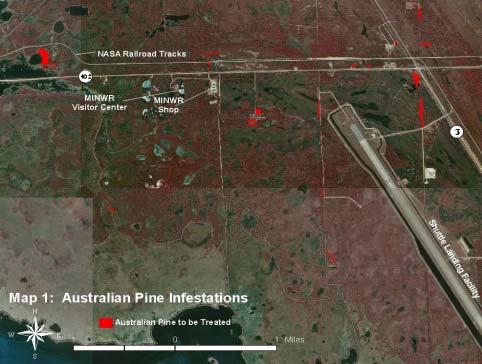
1 Mosquito Coast Regional Working Group Merritt Island Invasive Exotic Plant Control Projects PCL: Merritt Island National Wildlife Refuge Project Manager: U.S. Fish and Wildlife Service Ron Hight, Refuge Manager P.O. Box 6504, Titusville, Florida Phone: , Fax: Project ID: MC-025 County: Brevard PCL Size: 139,174 acres Project Size: 2,429 acres Fiscal Year 01/02 Project Cost: $28, In the early 1960s, NASA began to acquire the land east of Titusville that is now John F. Kennedy Space Center. In 1963, the acquisition was complete and NASA turned those lands not vital to the space program over to the U.S. Fish and Wildlife Service. Today, the 43-mile long barrier island is managed by the Department of the Interior as Merritt Island National Wildlife Refuge and Canaveral National Seashore. The refuge is adjacent to the Indian and Banana Rivers and Mosquito Lagoon. Approximately one-half of the refuge consists of brackish estuaries and marshes. The remaining land consists of coastal dunes, scrub oaks, pine forest, pine flatwoods, and palm and oak hammocks. Numerous rare plants and animals are found on the refuge. These include seventeen state-endangered plants, such as satinleaf (Chrysophyllum oliviforme), crested coralroot (Hexalectris spicata), Florida peperomia (Peperomia obtusifolia), beach star (Remirea maritima), bay cedar (Suriana maritima), coastal hoary pea (Tephrosia angustissima), and sea lavender (Tournefortia gnaphalodes). Three projects were conducted on the refuge in FY01/02. This first project was primarily directed at melaleuca control. Melaleuca was initially introduced to the refuge by early homesteaders that occupied the land before it became a refuge. Like other exotics, it was planted as an ornamental, for shade, or as a wind barrier, and it escaped into the natural wetlands of the area. Melaleuca trees were scattered throughout the project area, with the majority lightly infesting swales that run north and south through the marshes. Target Plants Common Name FLEPPC Rank Treatment Herbicide Melaleuca quinquenervia melaleuca Category I cut stump Arsenal Casuarina equisetifolia Australian pine Category I basal bark Garlon 4 Project ID: MC-016 Project Size: 100 acres Fiscal Year 01/02 Project Cost: $245, A second project was directed specifically at controlling Brazilian pepper. Early settlers brought it to Florida to cultivate as an ornamental plant. This project controlled Brazilian pepper along approximately 41 miles of dike roads in the Moore Creek and the Jack Davis Impoundments. Target Plants Common Name FLEPPC Rank Treatment Herbicide Schinus terebinthifolius Brazilian pepper Category I mechanical n/a Project ID: MC-017 Project Size: 109 acres Fiscal Year 01/02 Project Cost: $174, This third project primarily controlled Australian pine, with other species including bamboo, eucalyptus, and other exotics found north of the NASA security area on the refuge. Target Plants Common Name FLEPPC Rank Treatment Herbicide Casuarina equisetifolia Australian pine Category I basal/girdle/cut stump/foliar Garlon 4 hand pull n/a Schinus terebinthifolius Brazilian pepper Category I basal Garlon 4/Arsenal Albizia julibrissin mimosa Category I basal/girdle Garlon 4 Eucalyptus spp. eucalyptus n/a basal/cut stump/girdle Garlon 4 Bambusa spp. bamboo n/a cut stump Garlon 4/Roundup 16


2 17

3 18


4 Melaleuca lurking in the woods. Not fish bones toppled melaleuca trunks. 19


5 A dike road almost swallowed by Brazilian pepper. The heavy equipment rolls in... 20


6 Don t get carried away, Mr. Pepper-tree. Oops, too late! 21...and the way is clear!


7 An army of Australian pine advances on NASA! Fortunately, killing exotics is not rocket science. 22


8 Pine Island Phase II Invasive Exotic Plant Control County: Brevard PCL: Pine Island Conservation Area PCL Size: 879 acres Project Manager: Brevard County Parks & Recreation Scott Taylor, EEL Central Region Land Manager 2725 Judge Fran Jamieson Way, Bldg. B, Viera, Florida Phone: , Fax: Project ID: MC-019 Project Size: 65 acres Fiscal Year 01/02 Project Cost: $43, The 879± acre Pine Island Conservation Area (PICA) is located on North Merritt Island. The Merritt Island National Wildlife Refuge adjoins the north boundary of the PICA. The PICA was jointly purchased by the Brevard County and the St. Johns River Water Management District in The pine flatwoods island for which this conservation land is historically named is regionally unique in that large areas grade directly into the Indian River Lagoon and other areas exhibit rapid transitions to isolated freshwater marshes and impounded estuarine marsh and mangrove forest habitats that are fringing the Indian River Lagoon and embedded open water natural ponds and channels. Development activities on the PICA during the 1960s in support of sand mining and mosquito control operations significantly altered the hydrologic regime and structural integrity of the expansive estuarine marsh system historically characterizing this property. These land disturbances provided conditions that were exploited by invasive exotic pest plants, primarily Brazilian pepper, which is estimated to cover as much as 250 acres of the conservation area. This proposal targets removal of mainly Brazilian pepper and melaleuca from 65± acres of Indian River Lagoon shoreline, native mesic pine flatwoods, hydric hammock, fringing estuarine marsh, and mangrove forest natural community types located in the southwest quadrant of the conservation property. Brazilian pepper is found throughout most of the project area with the exception of the central core of the pine flatwoods. The densest concentrations of Brazilian pepper occur along the Indian River Lagoon shoreline and within the transitional and wet habitat types: hydric hammock, fringing estuarine marsh, and mangrove forest. Melaleuca is found primarily on a raised hammock embedded within the salt marsh community. A site assessment determined that approximately 35 acres of Brazilian pepper and 0.25 acre of melaleuca occur within the project area. Target Plants Common Name FLEPPC Rank Treatment Herbicide basal/cut stump Garlon 4 Schinus terebinthifolius Brazilian pepper Category I girdle/cut stump Arsenal hand pull n/a Melaleuca quinquenervia melaleuca Category I cut stump Arsenal 23 Brazilian pepper forms dense thickets (left). The fruits (above) are readily eaten by birds and widely dispersed.

9 24
10 Satellite Beach Invasive Exotic Plant Control County: Brevard PCL: Satellite Beach Oceanfront Wildlife and Habitat Preservation Site PCL Size: 18.3 acres Project Manager: City of Satellite Beach Recreation Department Tiffany Farrell, Environmental Education Coordinator 1089 South Patrick Drive, Satellite Beach, Florida Phone: , Fax: Project ID: MC-020 Project Size: 18.3 acres Fiscal Year 01/02 Project Cost: $12, The Satellite Beach site was acquired through the Florida Communities Trust. This site is composed of two tracts of undeveloped land separated by a 100-foot wide parking area comprising Hightower Beach Park. The two tracts encompass 18.3 acres with a total ocean frontage of 2,840 feet. The park is owned by Brevard County and is jointly managed by the County and the City. Natural communities consist of Beach Dune, Coastal Grassland, and Coastal Strand. The beach dune of the northern tract contains a significant patch of beach star (Cyperus maritima), shown in the Atlas of Florida Vascular Plants to be present in only five counties, with Brevard not being one of them. Smaller sections of coastal mock vervain (Glandularia maritima) exist in several locations. Both of these plant species are listed as endangered by the state. Additionally, the state threatened shell-mound pricklypear cactus (Opuntia stricta) is present in small patches. The beach along this site is an important sea turtle nesting site, and is the longest stretch of undisturbed beach between the Archie Carr Wildlife Refuge to the south and Canaveral National Seashore to the north. This project controlled Brazilian pepper and other exotic plants, which were scattered throughout the site. Target Plants Common Name FLEPPC Rank Treatment Herbicide Schinus terebinthifolius Brazilian pepper Category I basal, cut stump Garlon 4 Sansevieria trifasciata snake plant n/a cut stump Garlon 4 Carissa macrocarpa natal plum n/a cut stump Garlon 4 Kalanchoe daigremontiana life plant n/a foliar, hand pull Roundup 25

11 26
12 South Beaches Phase IV Invasive Exotic Plant Control County: Brevard PCL: Archie Carr National Wildlife Refuge PCL Size: acres Project Manager: Brevard County Parks & Recreation Ray Mojica, Land Manager 5560 North US Highway 1, Melbourne, Florida Phone: , Fax: Project ID: MC-022 Project Size: acres Fiscal Year 01/02 Project Cost: $48, The South Beaches project is a cooperative effort between several partners, including federal, state, and local agencies. The project includes several parcels of publicly owned conservation lands on the South Beaches of Brevard County. All of the property is located within the Archie Carr National Wildlife Refuge. The Refuge, designated by Congress in 1990, is recognized as one of the most important areas in the world for nesting loggerhead turtles and the most significant area in North America for nesting green turtles. Natural communities within the project area include Coastal Strand, Maritime Hammock, Beach Dune, and Mangrove Forest. This project is the fourth phase of an aggressive program to remove Brazilian pepper and Australian pine from publicly held lands on the south beaches of Brevard County. The Environmentally Endangered Lands Program, a department within the Parks and Recreation Department, submitted the previous three phases. This proposal called for the removal of Brazilian pepper with an average coverage of 43% on three parcels of land. Target Plants Common Name FLEPPC Rank Treatment Herbicide Schinus terebinthifolius Brazilian pepper Category I basal, cut stump, hand pull Garlon 4 Casuarina equisetifolia Australian pine Category I basal, girdle, cut stump Garlon 4 27

13 28
14 Sykes Creek Phase III Invasive Exotic Plant Control County: Brevard PCL: Sykes Creek Headwaters Mitigation Area PCL Size: 500 acres Project Manager: Brevard County Parks & Recreation Scott Taylor, EEL Central Region Land Manager 2725 Judge Fran Jamieson Way, Bldg. B, Viera, Florida Phone: , Fax: Project ID: MC-026 Project Size: 38.8 acres Fiscal Year 01/02 Project Cost: $45, This is the final step in the ongoing effort to remove invasive, exotic plants from the Sykes Creek Headwaters Mitigation Area. The area to be addressed in this project is the remaining 38.8 acres of the 188 acres of the SCHMA that require treatment. The entire Sykes Creek Headwaters Mitigation Area (SCHMA) includes two large land tracts (referred to as Phase I and II) on Merritt Island. Phase II (the southern tract) includes approximately 300 acres of salt marsh that are bordered by mosquito control impoundment dykes. The natural communities in Phase II include a mixture of bottomland forests, hydric hammocks, depression and tidal marshes and disturbed uplands. Both phases (I and II) are connected together through large culverts placed under Hall Road. Additionally, Phase II communicates with the Indian River Lagoon via culverts to the Barge Canal. Both Phase I and II comprise portions of what was once the original headwaters of Sykes Creek and are adjacent to the Merritt Island National Wildlife Refuge (MINWR) and included within the Indian River Blueway CARL project. Target Plants Common Name FLEPPC Rank Treatment Herbicide basal bark Garlon 4 Schinus terebinthifolius Brazilian pepper Category I girdle Arsenal hand pull n/a Casuarina equisetifolia Australian pine Category I girdle Garlon 4 29
15 Operation Pepper Sweep Invasive Exotic Plant Control County: Volusia PCL: see below PCL Size: various Project Manager: Volusia County Public Works David Farr 123 W. Indiana Avenue, Deland, Florida Phone: , Fax: Project ID: MC-024 Project Size: 3,681 acres Fiscal Year 01/02 Project Cost: $98, This project encompasses several federal, state, and county conservation lands: Canaveral National Seashore, Bulow Creek and North Peninsula State Parks, and Highbridge, Seabridge, Bicentennial, Riverbreeze, and Smyrna Dunes County Parks. The Mound Grove property was acquired for conservation purposes in 1985 and added to Bulow Creek State Park, which presently contains 5,117 acres. Bulow Creek State Park is managed as part of Tomoka Basin Geopark. After the citrus groves were abandoned in the mid-1900s, the uplands at Mound Grove reverted to Upland Mixed Forest. Brazilian pepper is locally common, particularly in the hammock-marsh transition area on the east side of Mound Grove and along the right-of-way on the north side of the Highbridge Road. Other natural communities include Estuarine Tidal Marsh and Shell Mound, which support populations of locally rare subtropical plants such as wild coffee (Psychotria nervosa), soapberry (Sapindus marginatus), and snowberry (Chiococca alba). The tidal marshes and wetland-upland transition zone at Mound Grove are important habitats for wetland dependent species. The natural communities of Canaveral National Seashore and other conservation lands in the project include Coastal Dune, Coastal Strand, Oak Scrub, Hardwood Hammock, Maritime Hammock, Mangrove Swamp, Salt Marsh, and Freshwater Marsh. Brazilian pepper totals about acres in sparse to dense stands throughout the project area. The County provided in-kind contributions of $48, for this project. Target Plants Common Name FLEPPC Rank Treatment Herbicide Schinus terebinthifolius Brazilian pepper Category I basal, cut stump Garlon 4 Dioscorea bulbifera air-potato Category I basal bark Garlon 4 Paederia foetida skunk vine Category I basal bark Garlon 4 30
16 31


 and")
17 Highbridge Park and surrounding conservation lands. Areas in red are exotic plant control areas. Seabridge Park and control area. Smyrna Dunes (left) and Riverbreeze Park (right) with control areas in red. 32
 with exotic")
18 Bicentennial Park with control areas in red. Canaveral National Seashore (outlined in green) with exotic control areas (in red). 33
19 Canaveral National Seashore Invasive Exotic Plant Control County: Volusia PCL: Canaveral National Seashore PCL Size: 57, acres Project Manager: Volusia County Public Works David Farr 123 W. Indiana Avenue, Deland, Florida Phone: , Fax: Project ID: MC-023 Project Size: 995 acres Fiscal Year 01/02 Project Cost: $37, Canaveral National Seashore (CNS) is located in southeast Volusia County and northeast Brevard County. The property is situated on a long barrier island adjacent to the Mosquito Lagoon, an Outstanding Florida Water. Natural communities within the project area include coastal dune, coastal strand, oak scrub, mangrove forest, salt marsh, and palm and oak hammocks. This project will control Brazilian pepper, Australian pine, and cogon grass found scattered across the project area. Brazilian pepper totals about 25 acres in stands ranging from 0.25 acres to 4 acres in size, as well as scattered single trees. Australian pine occurs in three stands totaling 1.1 acres. About 1.5 acres of cogon grass occurs along an access road. Target Plants Common Name FLEPPC Rank Treatment Herbicide Casuarina equisetifolia Australian pine Category I basal, cut stump Garlon 4 Imperata cylindrica cogon grass Category I foliar Rodeo Schinus terebinthifolius Brazilian pepper Category I basal, cut stump Garlon 4 Barrier I sl and-south Barrier I sl and-north Canaveral NS South Barrier Island South Mosquito Lagoon 34
Southwest Regional Working Group
 Southwest Regional Working Group The Southwest Regional Working Group liaison is Roger Clark, Lee County Parks and Recreation, 3410 Palm Beach Boulevard, Ft. Myers, Florida 33916, phone: 239-338-3343,
Southwest Regional Working Group
 Southwest Regional Working Group The Southwest Regional Working Group liaison is Roger Clark, Lee County Parks and Recreation, 3410 Palm Beach Boulevard, Ft. Myers, Florida 33916, phone: 941-338-3343,
Pinellas County Environmental Lands
 Pinellas County Environmental Lands In addition to traditional parks and recreation facilities, Pinellas County owns and manages a system of environmental lands that provides specialized resource-based
Conservation Lands. Conservation Lands Advisory Committee October 19, 2005
 Conservation Lands Advisory Committee October 19, 2005 Roland DeBlois Chief of Environmental Planning & Code Enforcement Community Development Department Beth Powell Conservation Lands Manager Parks Division
566± acres total - WILL DIVIDE Volusia County, FL
 L IC E N S E D HUNTING P RESERVE ts Q u a i l ahi ul anb l e are av r info! fo CALL TODAY LAKEFRONT PROPERTY PERFECTION This ranch lies on a natural sand ridge in North Volusia County, Florida and has
DEEP CREEK RANCH 566± acres total - WILL DIVIDE Volusia County, FL
 LICESED HUTIG PRESERVE Quail hunts are available CALL TODAY for info! LAKEFROT PROPERTY PERFECTIO This ranch lies on a natural sand ridge in orth Volusia County, Florida and has a gentle roll and boasts
Southeast Regional Working Group
 Southeast Regional Working Group The Southeast Regional Working Group liaison is Joe Maguire, Miami-Dade Parks and Recreation, 22200 S.W. 137 th Avenue, Miami, Florida 33170, phone: 305-257-0933, fax:
East Central Regional Working Group
 East Central Regional Working Group The East Central Regional Working Group liaison is Gregg Walker, 2849 Babylon Court, Oviedo, Florida 32765, phone: 407-359-0506, e-mail: asligregg@aol.com 13 Lake Tohopekaliga
STORNETTA BROTHERS COASTAL RANCH
 STORNETTA BROTHERS COASTAL RANCH Location: Surrounding Point Arena Lighthouse and immediately south of Manchester State Park Mendocino Co., CA Acres: 1,860 Resources: Over two miles of Pacific Ocean coastline
Wetlands Reservoirs of Biodiversity. Billy McCord, SCDNR
 Wetlands Reservoirs of Biodiversity Billy McCord, SCDNR Estuaries Tidal Deepwater Intertidal Salt Marsh Tidal Riverine Fresh & Brackish Deepwater Tidal Emergent Marsh Freshwater Riverine Seasonally Flooded
Florida Department of Environmental Protection Division of Recreation and Parks
 Florida Department of Environmental Protection Division of Recreation and Parks Land Honeymoon Island State Park Introduction Honeymoon Island State Park is a 2,810.16-acre public outdoor recreation and
Geographic Response Plan Map: EFL-40 ]^4011. ! Manatee [v NERR. National Park. Naval Facility. Piping Plover. Power Plant. Recreational Fishing
![Geographic Response Plan Map: EFL-40 ]^4011. ! Manatee [v NERR. National Park. Naval Facility. Piping Plover. Power Plant. Recreational Fishing](/thumbs/91/105050028.jpg "Geographic Response Plan Map: EFL-40 ]^4011. ! Manatee [v NERR. National Park. Naval Facility. Piping Plover. Power Plant. Recreational Fishing") 29 22'30"N 81 7'30"W!E(! EFL40-01 Basin Bulow Creek State Park Addison Blockhouse Historic State Park NRC - Ormond Beach Warehouse Equipment Site (ID JAX-E8) River Basin k k Marsh Aquatic Preserve!S( 200
29 22'30"N 81 7'30"W!E(! EFL40-01 Basin Bulow Creek State Park Addison Blockhouse Historic State Park NRC - Ormond Beach Warehouse Equipment Site (ID JAX-E8) River Basin k k Marsh Aquatic Preserve!S( 200
Brooker Creek Preserve Management Plan 2008 Update
 Brooker Creek Preserve Management Plan 2008 Update Plan approved by the Board of County Commissioners Pinellas County, Florida 19 August 2008 Pinellas County Department of Environmental Management Environmental
IMPACTS OF THE RECENT TSUNAMI ON THE BUNDALA NATIONAL PARK THE FIRST RAMSAR WETLAND IN SRI LANKA
 IMPACTS OF THE RECENT TSUNAMI ON THE BUNDALA NATIONAL PARK THE FIRST RAMSAR WETLAND IN SRI LANKA by C.N.B. Bambaradeniya, IUCN The World Conservation Union, Sri Lanka Country Office (Email: cnb@iucnsl.org)
FLORIDA DEPARTMENT OF ENVIRONMENTAL PROTECTION DIVISION OF RECREATION AND PARKS RECREATIONAL CARRYING CAPACITY GUIDELINES
 FLORIDA DEPARTMENT OF ENVIRONMENTAL PROTECTION DIVISION OF RECREATION AND PARKS RECREATIONAL CARRYING CAPACITY GUIDELINES THE SELECTION AND CAPACITY DETERMINATION OF USE SITES Introduction The Division
IOWA ORNITHOLOGISTS' UNION - Birding Sites in Dallas County
 IOWA ORNITHOLOGISTS' UNION - Birding Sites in Dallas County Printed on 7/19/2018 Beaver Bottoms Wetland (restricted) (Important Bird Area) GPS Coordinates:, Ownership: Private (see directions for access)
Segment 2: La Crescent to Miller s Corner
 goal of the USFWS refuges is to conserve, protect and enhance fish, wildlife and plants and their habitats for the continuing benefit of the American people. Refuge lands are used largely for fishing,
Niagara Natural Heritage Park
 A Future Proposal For the Niagara-on-the-Lake DND Lands....... Parks Canada Lakeshore Road Property 1 May, 2016 The Harmony Residents Group We are proposing a Natural Heritage Park be established on the
St. Christopher Camp and Conference Center s Outdoor education program for elementary and middle school students
 St. Christopher Camp and Conference Center s Outdoor education program for elementary and middle school students Since 1980, The Barrier Island Environmental Education Program has provided thousands of
Lecture 08, 22 Sep 2003 Role Playing. Conservation Biology ECOL 406R/506R University of Arizona Fall Kevin Bonine
 Lecture 08, 22 Sep 2003 Role Playing Conservation Biology ECOL 406R/506R University of Arizona Fall 2003 Kevin Bonine 1. Role Playing Exercise 2. Exam Wed -group portion outside - ~40 minutes individual,
14.0 NORTHERN CALIFORNIA COAST NORTHERN FOCUS AREA Description of Area The Land
 14.1 Description of Area 14.1.1 The Land The Northern California Coast - Northern Focus Area is composed of coastal Del Norte and Humboldt counties. The boundary extends eastward from the Pacific coast
Acquisition in fee simple of approximately one-half acre of property on the shore of Spring Lake to expand the Lakeside Beach Park.
 Lakeside Beach TF00-136 $122,550.00 in fee simple of approximately one-half acre of property on the shore of Spring Lake to exp the Lakeside Beach. 2000 River Ravines TF00-150 $910,000.00 in fee simple
Yuba Creek Natural Area Acquisition. Acme Township. Acme Township. TF Acquisition $1,576, Grand Traverse
 Yuba Creek Natural Area TF00-162 $1,576,021.00 in fee simple of 403 acres of critical wetls upl habitat with over 5,000 feet of frontage on Yuba Creek, a tributary to the east arm of Bay. 2000 Petobago
NEW YORK AVENUE TOWN HOME SITE
 NEW YOR AVENUE TOWN HOME SITE EXCLUSIVE LISTING DELAND, FLORIDA LOCATION The Property is located in DeLand, FL on the south side of New York Avenue (SR 44) between Frankfort Avenue on the east, Fairview
3.0 EXISTING PARK & RECREATION SPACE
 3.0 EXISTING PARK & RECREATION SPACE TOWN PARK & RECREATION SPACE An inventory of current parks and recreation area in the Town of Cedarburg is shown in Table 3. These areas total roughly 381.89 acres.
Figure 1 shows the evaluation area around Tailings Basin Cells 2E/1E. Two areas were evaluated for potential wetland impacts including:
 Barr Engineering Company 4700 West 77th Street Minneapolis, MN 55435-4803 Phone: 952-832-2600 Fax: 952-832-2601 www.barr.com An EEO Employer Minneapolis, MN Hibbing, MN Duluth, MN Ann Arbor, MI Jefferson
MANAGEMENT STATUS REPORT FOR CONSERVATION 20/20 PRESERVES QUARTER 3 REPORT (April-June 2016) August 11, 2016
 August 11, 2016") CAPE CORAL, PINE ISLAND, SANIBEL and MATLACHA PASS AREAS Charlotte Harbor Preserve 446 acres C20/20 Preserves adjacent to Charlotte Harbor Preserve State Park Nominations 58, 91, 95, 96, 99, 137, 262,
CAPE CORAL, PINE ISLAND, SANIBEL and MATLACHA PASS AREAS Charlotte Harbor Preserve 446 acres C20/20 Preserves adjacent to Charlotte Harbor Preserve State Park Nominations 58, 91, 95, 96, 99, 137, 262,
THOMAS A. SWIFT METROPARK Introductions History Present Conditions Future Development Plans Implementation Strategies Statistics
 THOMAS A. SWIFT METROPARK Introductions History Present Conditions Future Development Plans Implementation Strategies Statistics Introduction As an open meadow park positioned along the Mahoning River,
VERP Assignment for Ft. Fisher State Recreation Area
 Case Background VERP Assignment for Ft. Fisher State Recreation Area Fort Fisher State Recreation Area is a jewel of the southeastern coast of North Carolina. Comprised of a wide variety of maritime ecosystems,
Michipicoten Island Regional Plan
 Michipicoten Island Regional Plan This is one of twenty Regional Plans that support implementation of the Lake Superior Biodiversity Conservation Strategy (Strategy). The Strategy, prepared and overseen
The Sand Ridge - Tulare Lake Conservation Report proposes the following recommendations:
 Introduction Creighton Ranch. Pixley National Wildlife Refuge. Allensworth State Historic Park. Sand Ridge. Deer Creek. Located in the Tulare Lake Basin, the Sand-Ridge - Tulare Lake Planning Area features
Florida s Space Coast Fast Facts
 FOR IMMEDIATE RELEASE Contact: Bonnie.King@visitspacecoast.com Florida s Space Coast Fast Facts Description: Located: Nature/Wildlife: The Space Coast boasts 72 miles (110 km) of beaches, the longest stretch
2.0 Physical Characteristics
 _ 2.0 Physical Characteristics 2.1 Existing Land Use for the Project The site is comprised of approximately 114 acres bounded by Highway 101 to the north, the existing town of Los Alamos to the east, State
THE FLORIDA TRAIL ASSOCIATION. Congressional Report. Trail Operations Report
 THE FLORIDA TRAIL ASSOCIATION Congressional Report 2017 Trail Operations Report 1 Like on Facebook: facebook.com/floridatrailassociation Follow on Twitter: twitter.com/floridatrail See on Instagram: instagram.com/floridatrail
David Magney Environmental Consulting
 David Magney Environmental Consulting DELINEATION OF JURISDICTIONAL WATERS AND RIPARIAN HABITATS FOR LYONS CANYON RANCH, NEWHALL, CALIFORNIA Prepared for: UNITED STATES ARMY CORPS OF ENGINEERS and CALIFORNIA
What Is An Ecoregion?
 Ecoregions of Texas What Is An Ecoregion? Ecoregion a major ecosystem with distinctive geography, characteristic plants and animals, and ecosystems that receives uniform solar radiation and moisture Sometimes
Chapter 2: Summary of Existing Open Space System
 Chapter 2: Summary of Existing Open Space System In 1976, the Wake County Board of Commissioners established the Wake County Parks and Recreation Department in order to provide park facilities and programs
DATE: January 19, WCA Governing Board. Johnathan Perisho, Project Manager. Mark Stanley, Executive Officer
 Item 14 DATE: January 19, 2017 TO: FROM: THROUGH: SUBJECT: WCA Governing Board Johnathan Perisho, Project Manager Mark Stanley, Executive Officer Item 14: Consideration of a resolution to accept an acquisition
Figure 7. Dragline at Cape Coral, Figure 8. Cape Coral oblique aerial photograph, 1959.
 The dredge-and-fill method, which would later be criticized for its environmental impact, employed in the peak years of the early 1960s as many as four dredges and ten draglines, which at times operated
Te Manahuna Consulting
 Assessment of the natural values at the proposed centre pivot irrigation site and surrounds on Ben Ohau Station, Mackenzie Basin, New Zealand August 2016 Abstract The natural values of the area proposed
Coast to Coast Connector Summit
 Project Partners Welcome to the Coast to Coast Connector Summit Winter Garden, Florida City Hall October 1, 2014 1 Why are we here? Objectives 1. Inform key stakeholders on the current state of the C2C
On the Edge with Mangroves
 On the Edge with Mangroves (Author s Note: This is the twenty-second in a series of articles by members of the City of Sanibel Vegetation Committee dealing with vegetative matters of concern to island
STREAKED HORNED LARK. Conservation of a threatened species in an industrial landscape. Cat Brown US Fish and Wildlife Service
 STREAKED HORNED LARK Conservation of a threatened species in an industrial landscape Cat Brown US Fish and Wildlife Service HISTORICAL & CURRENT RANGE Streaked Horned Lark Distribution Historical Range:
Lewis and Clark National Historic Trail
 National Trails System Land and Water Conservation Fund FY2014 Lewis and Clark National Historic Trail Total LWCF Request: $ 3,130,000 Project Name Agency District # Tracts Acres Total Cost Columbia River
Treaty Oaks Ranch 323+/- Acres Hood County, Texas $1,776,500
 Bret Polk Mobile: (254) 965-0349 Office: (214) 361-9191 Treaty Oaks Ranch 323+/- Acres Hood County, Texas $1,776,500 LOCATION: The ranch is located in a desirable area 10+/- miles south of Granbury, Texas,
Northeast Quadrant Distinctive Features
 NORTHEAST QUADRANT Northeast Quadrant Distinctive Features LAND USE The Northeast Quadrant includes all the area within the planning area that is east of Interstate 5 and to the north of State Route 44.
Priority Species, Communities, Ecosystems, and Threats
 Priority Species, Communities, Ecosystems, and Threats East Gippsland Regional Catchment Strategy 2015/2016 1.0 Objective This document aims to assist in the preparation of project applications for 2015-2016
 MANAGEMENT STATUS REPORT FOR CONSERVATION 20/20 PRESERVES July 2012 (April 1 June 30) July 2012 CAPE CORAL, PINE ISLAND, and MATLACHA PASS AREAS Charlotte Harbor Preserve 400 acres C20/20 Preserves adjacent
Florida Department of Environmental Protection Division of Recreation and Parks
 Florida Department of Environmental Protection Division of Recreation and Parks Land Edward Ball Wakulla Springs State Park Introduction Edward Ball Wakulla Springs State Park is a 6,055.2-acre public
OPG, Nuclear 2
 B iodiversity Assessment Building a Biodiversity Management Plan November 24, 2011 OPG, Nuclear 2 Biodiversity Assessment What habitat, or your site? potential habitat, is available on What species of
proof Northwest District
 1 Northwest District The Northwest Florida Water Management District is the most rural of all five water management districts. From just east of Tallahassee west to the Florida/Alabama line, and from the
(apr l(x)irrnr. brttctx5~~ (H+H J )TVH~HTH. national Seaside. sjludu rora.
irrnr. brttctx5~~ (H+H J )TVH~HTH. national Seaside. sjludu rora.") r sjludu rora. national Seaside IU Inc/uatitq (H+H J )TVH~HTH brttctx5~~ (apr l(x)irrnr BRAnOfOFPLflnninG-nflTIOIlAL. PARK SERVICE D E PflRT m E n T OF TH E I n T E RIOK. NATIONAL SEASHORE PJSCriiATIOIIAL
r sjludu rora. national Seaside IU Inc/uatitq (H+H J )TVH~HTH brttctx5~~ (apr l(x)irrnr BRAnOfOFPLflnninG-nflTIOIlAL. PARK SERVICE D E PflRT m E n T OF TH E I n T E RIOK. NATIONAL SEASHORE PJSCriiATIOIIAL
TOWARDS SUSTAINABLE MANAGEMENT OF MARINE AND COASTAL HABITATS ASIA- PACIFIC DAY FOR THE OCEAN
 TOWARDS SUSTAINABLE MANAGEMENT OF MARINE AND COASTAL HABITATS WANNAKIAT THUBTHIMSANG PHUKET MARINE BIOLOGICAL CENTER, DMCR, THAILAND ASIA- PACIFIC DAY FOR THE OCEAN 20 NOVEMBER 2018, CONFERENCE ROOM 4,
Title/Name of the area: Chwaka Bay, Zanzibar
 Title/Name of the area: Chwaka Bay, Zanzibar Presented by: Dr. Charles Lugomela, Ag. Head, Department of Aquatic Sciences and Fisheries, University of Dar es Salaam, P.O. Box 35064 Dar es Salaam, Tanzania
5 proposed wetland sites
 PROPOSED WETLAND SITES OF VIETNAM Hoang Van Thang, PhD. 5 proposed wetland sites 1. Lak Lake 2. Lo Go Sa Mat 3. Tram Chim 4. UMi Minh hthuong 5. Mui Ca Mau Lak Lake Coordinates: 12o24 22 12o26 25 N 108o09
Finn Creek Park. Management Direction Statement Amendment
 Finn Creek Park Management Direction Statement Amendment November 2013 Management Direction Statement Amendment Approved by: Jeff Leahy Regional Director, Thompson Cariboo BC Parks November 12, 2013 Date
Virginian Atlantic (Ecoregion 8)
") Virginian Atlantic (Ecoregion 8) Background The Virginian Atlantic Ecoregion extends from the south side of Cape Cod to Cape Hatteras in North Carolina. The waters of the ecoregion are a mix of cold and
Virginian Atlantic (Ecoregion 8) Background The Virginian Atlantic Ecoregion extends from the south side of Cape Cod to Cape Hatteras in North Carolina. The waters of the ecoregion are a mix of cold and
April 10, Mark Stiles San Juan Public Lands Center Manager 15 Burnett Court Durango, CO Dear Mark,
 Mark Stiles San Juan Public Lands Center Manager 15 Burnett Court Durango, CO 81301 Dear Mark, We are pleased to offer the following comments on the draft San Juan Public Lands Center management plans
MANAGEMENT STATUS REPORT FOR CONSERVATION 20/20 PRESERVES FY QUARTER 1 REPORT (October-December 2018) January 10, 2018
 January 10, 2018") CAPE CORAL, PINE ISLAND, SANIBEL and MATLACHA PASS AREAS Charlotte Harbor Buffer Preserve 448.61 acres adjacent to Charlotte Harbor Preserve State Park Nominations 58, 91, 95, 96, 99, 137, 262, 280, 372,
CAPE CORAL, PINE ISLAND, SANIBEL and MATLACHA PASS AREAS Charlotte Harbor Buffer Preserve 448.61 acres adjacent to Charlotte Harbor Preserve State Park Nominations 58, 91, 95, 96, 99, 137, 262, 280, 372,
FY 2018/19 CENTRAL FLORIDA MPO ALLIANCE - LIST OF PRIORITY PROJECTS
 Priority FY 2018/19 CENTRAL FLORIDA ALLIANCE - LIST OF PRIORITY PROJECTS FY 2018-2019 SIS HIGHWAY PROJECTS FDOT Financial Management Number Project Name From To Work Description Latest Project Phase Funded
Green Legacy. Securing our. Greenlands Strategy
 Greenlands Strategy Securing our Green Legacy Together we can create an interconnected network of Greenlands for the health and well-being of the environment and future generations Caring for the Credit
Bayview Escarpment. Interim Management Statement
 Bayview Escarpment Interim Management Statement Bayview Escarpment Provincial Nature Reserve Interim Management Statement January 15, 1995 REGIONAL DIRECTOR'S APPROVAL STATEMENT This Interim Management
Sheffield Island Camden County, GA
 For Sale $3,150,000 Sheffield Island Camden County, GA 452.5 Total Acres 230 Estimated Upland Acres William Lattimore 912.596.7019 Overview A rare opportunity to own a portion of a pristine island off
NOTICE OF INTENT MAPS WITH DESCRIPTIONS
 NOTICE OF INTENT MAPS WITH DESCRIPTIONS Location Map(s) to Accompany Notice of Intent The small corner map embedded in the lower left corner of the large map above shows the location of the three national
PROPOSED QUARRY FOOTPRINT PHASE 2 PHASE 3. PHASE 5 West. PHASE 5 East. PHASE 6 West. PHASE 6 East PHASE 7 PHASE 4 PHASE 1
 PHASE 4 \\Cd1220-f02\01609\active\2001 Active Projects\1100-1199\G1188\graphics\GIS\MXD\_Final Draft Sept 2008\MXD\Section_5\62601188_Fig5-0_ProposedQuarryFootprint_01Dec08_NJB.mxd PHASE 7 PHASE 5 West
Bon Portage Island Conservation Campaign
 Bon Portage Island Conservation Campaign Protecting a Coastal Treasure Final Report to Nova Scotia Habitat Conservation Fund September 2012 Protection of Bon Portage Island Over the course of this two-year
Southwest Quadrant Distinctive Features
 SOUTHWEST QUADRANT Southwest Quadrant Distinctive Features LAND USE The 31.17 square mile Southwest Quadrant includes all the area within the planning area west of I-5 and south of the Sacramento River.
Conservation Area Management Statement
 Conservation Area Management Statement Miller Creek Wildlife Area Resolution #: Approval: Issue Date: Date of Last Revision: Table of Contents 1. Purpose....... 1 2. Property Description...... 1 2.1. Legal
The Partnership Wild & Scenic Rivers Program
 BUDGET REQUEST FISCAL YEAR 2017 Proven, cost-effective protection for 770 miles of rivers and thousands of acres of riparian land Westfield River, MA (L) and Farmington River, CT (R) Partnership Wild &
An NPS Wetland of International Significance!
 An NPS Wetland of International Significance! A World Class Tourism Destination Linda Friar Chief of Public Affairs 305-242-7714 Linda_Friar@nps.gov The Everglades - International Recognition as a special
Town of Oakfield Agricultural and Farmland Protection Plan
 SECTION III COMMUNITY OVERVIEW A. Regional Setting / Location The Town of Oakfield is located in the northwestern portion of Genesee County. Located west of New York's Finger Lakes, the Town is uniquely
$850,000 Awarded to 20 Organizations
 $850,000 Awarded to 20 Organizations The Conservation Alliance is pleased to fund the following organizations to support their efforts to protect wild lands and waterways for their habitat and recreation
photos Department of Environment and Conservation Biodiversity Conservation
 photos Department of Environment and Conservation Biodiversity Conservation EcoEducation - making the connections to biodiversity conservation Do you consider experiential learning of biodiversity in the
National Forests and Grasslands in Texas
 United States Department of Agriculture Forest Service National Forests and Grasslands in Texas Sam Houston NF 394 FM 1375 West New Waverly, Texas 77358 Phone 936-344-6205 Dear Friends, File Code: 1950
Hawke s Bay Regional Parks Network. Pekapeka Regional Park Individual Park Plan
 Hawke s Bay Regional Parks Network Pekapeka Regional Park Individual Park Plan 2015-2024 Hawke s Bay Regional Council 159 Dalton Street Private Bag 6006 Napier 4110 Hawke s Bay New Zealand Telephone: 0800
KOOTENAY LAKE PROVINCIAL PARK (MIDGE CREEK SITE)
") KOOTENAY LAKE PROVINCIAL PARK (MIDGE CREEK SITE) PURPOSE STATEMENT AND ZONING PLAN February 2003 Approved by: KOOTENAY LAKE PROVINCIAL PARK (Midge Creek Site) Purpose Statement and Zoning Plan Primary
KOOTENAY LAKE PROVINCIAL PARK (MIDGE CREEK SITE) PURPOSE STATEMENT AND ZONING PLAN February 2003 Approved by: KOOTENAY LAKE PROVINCIAL PARK (Midge Creek Site) Purpose Statement and Zoning Plan Primary
Annual maintenance figures include areas that were re-treated in previous years, so the cumulative acreage is greater than the estimated total area
 1 Annual maintenance figures include areas that were re-treated in previous years, so the cumulative acreage is greater than the estimated total area infested. MANAGER COST ACRES Cities $501,169 1,201
IOWA ORNITHOLOGISTS' UNION - Birding Sites in Cerro Gordo County
 IOWA ORNITHOLOGISTS' UNION - Birding Sites in Cerro Gordo County Printed on 11/17/2018 Blue-wing Marsh GPS Coordinates: 43.0834956379463,-93.4430980682373 Pure natural area primarily used for hunting.
MANAGEMENT STATUS REPORT FOR CONSERVATION 20/20 PRESERVES QUARTER 1 REPORT (October - December 2017) February 8, 2018
 February 8, 2018") CAPE CORAL, PINE ISLAND, SANIBEL and MATLACHA PASS AREAS Charlotte Harbor Buffer Preserve 446 acres adjacent to Charlotte Harbor Preserve State Park Nominations 58, 91, 95, 96, 99, 137, 262, 280, 372,
CAPE CORAL, PINE ISLAND, SANIBEL and MATLACHA PASS AREAS Charlotte Harbor Buffer Preserve 446 acres adjacent to Charlotte Harbor Preserve State Park Nominations 58, 91, 95, 96, 99, 137, 262, 280, 372,
HAROLD E. ALEXANDER SPRING RIVER WILDLIFE MANAGEMENT AREA
 HAROLD E. ALEXANDER SPRING RIVER WILDLIFE MANAGEMENT AREA HAROLD E. ALEXANDER SPRING RIVER WILDLIFE MANAGEMENT AREA Prepared by: Randy Brents Jr (Fire Management Officer) Dallas Harrell (Area Biologist)
(Short Listing) DUPUYER ACREAGE, ROCKY MOUNTAN FRONT
 DUPUYER ACREAGE, ROCKY MOUNTAN FRONT") (Short Listing) DUPUYER ACREAGE, ROCKY MOUNTAN FRONT This unique property is located 8½ miles northwest of Dupuyer, Montana and approximately thirty 30 miles northwest of Choteau, Montana. Great Falls
(Short Listing) DUPUYER ACREAGE, ROCKY MOUNTAN FRONT This unique property is located 8½ miles northwest of Dupuyer, Montana and approximately thirty 30 miles northwest of Choteau, Montana. Great Falls
Sand Lakes Provincial Park. Draft Management Plan
 Sand Lakes Provincial Park Draft Management Plan 2 Sand Lakes Provincial Park Table of Contents 1. Introduction... 3 2. Background... 3 3. Park Purpose... 5 4. Park Management Guidelines... 6 Appendix...
SECTION 3 GENERAL DESCRIPTION OF THE RIVER BASIN
 SECTION 3 GENERAL DESCRIPTION OF THE RIVER BASIN SECTION 3 GENERAL DESCRIPTION OF THE RIVER BASIN River basin description. A general description of the river basin or subbasin, as appropriate, in which
DOYLE SPRINGS PLANNING UNIT Kern-Tule River Watershed
 Existing Conditions & Uses Overview Consists of a mostly forested parcel with small hydropower developments and part of a private recreation cabin development, along with two small transmission line corridor
Bin Location Latitude Longitude Bin Address City
 Bin Location Latitude Longitude Bin Address City Lake Dias 29.167866-81.300083 5320 State Rd. 11 DeLeon Springs Cypress Lake 29.0586-81.2584 1700 First Ave. DeLand Ed Stone Fishing 29.009433-81.382316
BIRDING Lake Fayetteville
 BIRDING Lake Fayetteville Lake Fayetteville is an impoundment of Clear Creek, created as a water supply for Fayetteville in 1949. With development of other water supplies, especially Beaver Lake, Lake
Use of Wetlands for Sustainable Tourism Management
 Use of Wetlands for Sustainable Tourism Management Christine Lim a and Michael McAleer b a School of Tourism and Hotel Management, Griffith University (christine.lim@mailbox.gu.edu.au) b Department of
Region 1 Piney Woods
 Region 1 Piney Woods Piney Woods 1. This ecoregion is found in East Texas. 2. Climate: average annual rainfall of 36 to 50 inches is fairly uniformly distributed throughout the year, and humidity and temperatures
GUIDE TO SCOUTING. at Miami Dade County Park & Recreation NATURE CENTERS
 GUIDE TO SCOUTING at Miami Dade County Park & Recreation NATURE CENTERS GUIDE TO SCOUTING Dear Boy and Girl Scout Leaders, Scouting has long been known to be a rewarding and valuable part of many people
SOUTH SECTION TRAIL SITES as of Mon Oct
 SOUTH SECTION TRAIL SITES as of Mon Oct. 16 2017 Partial Site is open but some hiking trails/facilities may be closed Closed Site is closed until further notice Open Site is open Unknown We have no information
MARBLE RIVER PROVINCIAL PARK
 MARBLE RIVER PROVINCIAL PARK PURPOSE STATEMENT AND ZONING PLAN March 2003 MARBLE RIVER PROVINCIAL PARK Purpose Statement and Zoning Plan Primary Role The primary role of Marble River Park is to protect
 AGREEMENT Between Director of the Białowieża National Park, based in Białowieża (Poland) and Director of the National Park Bialowieża Forest, based in Kamieniuki (Belarus) and Head Forester of the Białowieża
MARINE PROTECTED AREAS LESSON PLAN Water Parks
 Marine Protected Areas U. S. Marine Protected Areas Lesson Plan MARINE PROTECTED AREAS LESSON PLAN Water Parks Theme U.S. Marine Protected Areas Links to Overview Essays and Resources Needed for Student
Case Study: 1. The Clarence River Catchment
 Case Study: 1. The Clarence River Catchment The NSW coastline is a great natural asset, making an enormous contribution to the economy. The resources of coastal catchments such as the Clarence River Catchment,
South Texas Plains. Texas, Our Texas
 South Texas Plains This is a region characterized by considerable variety. Climatically, the South Texas Plains region is sub-humid to dry. The in the north part of the South Texas, erosion of the Edwards
National Protected Area Systems Analysis Case Study: Gra Gra Lagoon National Park
 ational Protected Area ystems Analysis Case tudy: Gra Gra Lagoon ational Park Problem statement: How does Gra Gra Lagoon ational Park fit in the ational Protected Areas ystem and how does it relate to
X. WHATCOM CREEK SMA. X.1 Watershed Analysis. X.1.1 Landscape Setting
 X. WHATCOM CREEK SMA Summary: The entire length of Whatcom Creek is located within the City of Bellingham. SMA jurisdiction associated with this creek is approximately 300 acres. Land use is dominated
Terrestrial Protected Area Nomination: Central Mangrove Wetland South-West, Grand Cayman
 Terrestrial Protected Area Nomination: Central Mangrove Wetland South-West, Grand Cayman The attached nomination, proposing that a parcel of land in the Central Mangrove Wetland be made a Protected Area
Huge earthquake/tsunami disturbance, autonomous ecosystem recovery and the human impact of reconstruction in the Sendai Bay sand-dune coastal ecotone
 15 November 2013, Sendai International Center, Sendai, Japan The First Asia Parks Congress WG1: Natural disaster and protected areas Huge earthquake/tsunami disturbance, autonomous ecosystem recovery and
Appendix C. Past and Current Management of Selected Tidal Wetland Sites
 Appendix C. Past and Current Management of Selected Tidal Wetland Sites Maps and photographs of wetland sites can be found at http://www.elkhornslough.org/tidalwetlandproject. Site 1. Parsons Slough/South