PROPOSED QUARRY FOOTPRINT PHASE 2 PHASE 3. PHASE 5 West. PHASE 5 East. PHASE 6 West. PHASE 6 East PHASE 7 PHASE 4 PHASE 1
|
|
|
- Abel Bryan
- 5 years ago
- Views:
Transcription

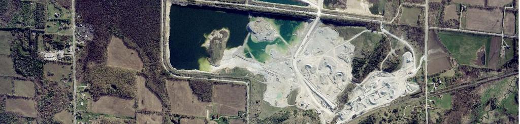
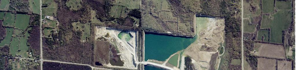
1 PHASE 4 \\Cd1220-f02\01609\active\2001 Active Projects\ \G1188\graphics\GIS\MXD\_Final Draft Sept 2008\MXD\Section_5\ _Fig5-0_ProposedQuarryFootprint_01Dec08_NJB.mxd PHASE 7 PHASE 5 West PHASE 6 West PHASE 5 East PHASE 6 East Sub-System Area Boundary Proposed Quarry Footprint FIGURE NO. 5.0 PROPOSED QUARRY FOOTPRINT Date Prepared: December 18, 2008

2 U26 U25 BCA-1 BCA-2 AREA B U1 U2 U3 U4 U5 W1 U28 U24 U23 W2-a W2-N W2-S U29 W:\active\2001 Active Projects\ \G1188\graphics\GIS\MXD\_Final Draft Sept 2008\MXD\Section_5\ _Fig5-1_WetlandCommunities_22Dec08_NJB.mxd U27 W4 W6 U21 U13 U22 W3 W5 W7 U12 U11 W8 U14 W2-b W9-a W9-b U8 U9 U10 W10-e U7 U30 U15 U6 U18 W9-S W10-d W11 W9-N W10-c W10-f U16 ESCARPMENT WETLANDS U19 U17 W10-b W10 W10-a U20 SEEPS Sub-System Area Boundaries Category 1 Provincially Significant Wetland 2008 Remnant and Low Function Wetland. No longer merits designation as PSW. Other Wetland, High Function Other Wetland, Low Function Other Wetland, Undetermined FIGURE NO. 5.1 Scotch Block Tributary WETLAND COMMUNITIES Date Prepared: December 22, 2008 ± * Boundary based on field investigations and air photo interpretation.
3 !. W:\active\2001 Active Projects\ \G1188\graphics\GIS\MXD\_Final Draft Sept 2008\MXD\Section_5\ _Fig5-2_EndangeredThreatenedSpecies_04Feb09_NJB.mxd H3 H4!(!>!(!>!(!(!(!(!(!(!(!( H15!. H43 H14 H10 ESCARPMENT WETLANDS H7 SEEPS Sub-System Area Boundary ± Scotch Block Tributary Category 1 Significant Habitat!. Hooded Warbler (generalized location) Jefferson Salamander Confirmed Breeding Habitat Suitable JESA Summer and Winter Habitat (mature deciduous and mixed forests within 250m of confirmed breeding pools excluding highly disturbed or narrow wooded areas e.g. hedgerows) No Category!> Not Retainable!( Butternut - Health Butternut - Unhealthy (Management to be determined in consultation with MNR) Where site access was available, field surveys were conducted. Where site access was not permitted, lands were characterized by agency data, air photo interpretation, and road side reconnaissance. Only station locations and individual species observations are depicted above. All habitat types were investigated during surveys for breeding birds, breeding pairs and sensitive species. Salamander habitat is assumed to extend onto adjacent lands. American Ginseng locations provided to MNR not shown on map. FIGURE NO. 5.2 ENDANGERED AND THREATENED SPECIES Date Prepared: February 4, 2009


4 WD - 1 WD - 2 WD - 3 W:\active\2001 Active Projects\ \G1188\graphics\GIS\MXD\_Final Draft Sept 2008\MXD\Section_5\ _Fig5-3_WoodlandCommunities_27Nov08_SSL.mxd ESCARPMENT WETLANDS SEEPS Existing Licenced Lands Sub-System Area Boundaries No Category Significant Woodlands (Forested Areas that meet the Woodland Boundary criteria as per section 5.2.3, and the criteria for significance in Regional Official Plan) Other Woodlands (Forested Areas that meet the Woodland Boundary criteria as per section 5.2.3, but do not meet the criteria for significance in Regional Official Plan) FIGURE NO. 5.3 WOODLAND COMMUNITIES Date Prepared: November 27, 2008 Refer to Figure 4.4 for ELC descriptions.


 Habitat for the West Virginia White Butterfly Habitat for Area Sensitive Birds, Rare Birds, Rare")


5 3rd LINE 22nd SIDE ROAD \\Cd1220-f02\01609\active\2001 Active Projects\ \G1188\graphics\GIS\MXD\_Final Draft Sept 2008\MXD\Section_5\ _Fig5-4_SignificantWildlifeHabitat_27Nov08_SSL.mxd 17th SIDE ROAD ESCARPMENT WETLANDS SEEPS 4th LINE Sub-System Area Boundaries Habitat for Species of Conservation Concern (Excludes Threatened/Endangered Fig 5.2) Habitat for the West Virginia White Butterfly Habitat for Area Sensitive Birds, Rare Birds, Rare Mammals (in large forest blocks) Significant Amphibian Woodland Breeding Ponds FIGURE NO. 5.4 Where site access was available, field surveys were conducted. Where site access was not permitted, lands were characterized by agency data, air photo interpretation, and road side reconnaissance. Only station locations and individual species observations are depicted above. All habitat types were investigated during surveys for breeding birds, breeding pairs and sensitive species. Salamander habitat is assumed to extend onto adjacent lands. SIGNIFICANT WILDLIFE HABITAT Date Prepared: December 18, 2008
6 H19 \\Cd1220-f02\01609\active\2001 Active Projects\ \G1188\graphics\GIS\MXD\_Final Draft Sept 2008\MXD\Section_5\ _Fig5-5_FisheriesResources_01Dec08_NJB.mxd H30 H5 H1 H16 H11 H42 ESCARPMENT WETLANDS SEEPS Existing Licenced Lands Sub-System Area Boundaries Ponds where fish have been observed Ephemeral Wetland Flow High Sensitivity Low Sensitivity FIGURE NO. 5.5 FISH AND AQUATIC RESOURCES Date Prepared: December 18, 2008 Fishery Resources are broadly and conservatively defined to encompass all of the effectively isolated ponds, tributaries, drainage features and encompassing wetland flow areas in the Local System, regardless of degree of connectivity or presence of fish.


 SPEYSIDE ESCARPMENT WOODS")
 Environmentally")

7 BLACK CREEK ACTON (ESA #47) AREA B ACTON SWAMP (ESA #28) Adjusted based on orthorectified photo Adjusted to reflect Phase 3 Adjusted to reflect Phase 2 W:\active\2001 Active Projects\ \G1188\graphics\GIS\MXD\_Final Draft Sept 2008\MXD\Section_5\ _Fig5-6_DesignatedAreas_27Nov08_SSL.mxd REGIONAL SPEYSIDE FOREST (ANSI) SPEYSIDE ESCARPMENT WOODS (ESA #29) ESCARPMENT WETLANDS SEEPS Sub-system Area Boundaries Life Science ANSI (MNR NRVIS Boundary) Environmentally Sensitive Area (MNR NRVIS Boundary) Adjusted Environmentally Sensitive Area Boundary FIGURE NO. 5.6 DESIGNATED AREAS Date Prepared: November 27, 2008
8 \\Cd1220-f02\01609\active\2001 Active Projects\ \G1188\graphics\GIS\MXD\_Final Draft Sept 2008\MXD\Section_5\ _Fig5-7_ConstraintsCategory1and2_27Nov08_SSL.mxd Sub-System Area Boundary Category 1 (See Figs 5.1 and 5.2) Provincially Significant Wetlands and Significant Habitat for Endangered and Threatened Species (See Figs 5.1, 5.3, 5.4, 5.5, and 5.6) Other Wetlands, Significant Wildlife Habitat, Significant Woodlands, Fish Habitat, ANSI and ESA FIGURE NO. 5.7 FEATURES: CATEGORY 1 and 2 Date Prepared: December 19, 2008


9 PHASE 4 \\Cd1220-f02\01609\active\2001 Active Projects\ \G1188\graphics\GIS\MXD\_Final Draft Sept 2008\MXD\Section_5\ _Fig5-8_ProposedQuarryFootprint_Constraints_27Nov08_SSL.mxd PHASE 7 PHASE 5 West PHASE 6 West PHASE 5 East PHASE 6 East Sub-System Area Boundary Proposed Quarry Footprint Category 1 (See Figs 5.1 and 5.2) Provincially Significant Wetlands and Significant Habitat for Endangered and Threatened Species (See Figs 5.1, 5.3, 5.4, 5.5, and 5.6) Other Wetlands, Significant Wildlife Habitat, Significant Woodlands, Fish Habitat, ANSI and ESA FIGURE NO. 5.8 PROPOSED QUARY FOOTPRINT WITH FEATURES: CATEGORY 1 and 2 Date Prepared: December 11, 2008
Rouge National Park. Opportunities and Challenges
 Rouge National Park Opportunities and Challenges January 2013 Rouge Park Finch Meander Rouge Beach at Lake Ontario Toronto GLWQA Area of Concern Rouge National Park Nationally Significant First Nation
Planning & Building Department
 Page 1 of Report Planning & Building Department To: Subject: Community Development Committee Protecting Escarpment Rural Land (PERL) Proposed Niagara Escarpment Plan Amendment Niagara Escarpment Commission
Niagara Natural Heritage Park
 A Future Proposal For the Niagara-on-the-Lake DND Lands....... Parks Canada Lakeshore Road Property 1 May, 2016 The Harmony Residents Group We are proposing a Natural Heritage Park be established on the
Conservation Area Management Statement
 Conservation Area Management Statement Miller Creek Wildlife Area Resolution #: Approval: Issue Date: Date of Last Revision: Table of Contents 1. Purpose....... 1 2. Property Description...... 1 2.1. Legal
HAROLD E. ALEXANDER SPRING RIVER WILDLIFE MANAGEMENT AREA
 HAROLD E. ALEXANDER SPRING RIVER WILDLIFE MANAGEMENT AREA HAROLD E. ALEXANDER SPRING RIVER WILDLIFE MANAGEMENT AREA Prepared by: Randy Brents Jr (Fire Management Officer) Dallas Harrell (Area Biologist)
OPG, Nuclear 2
 B iodiversity Assessment Building a Biodiversity Management Plan November 24, 2011 OPG, Nuclear 2 Biodiversity Assessment What habitat, or your site? potential habitat, is available on What species of
Wetlands Reservoirs of Biodiversity. Billy McCord, SCDNR
 Wetlands Reservoirs of Biodiversity Billy McCord, SCDNR Estuaries Tidal Deepwater Intertidal Salt Marsh Tidal Riverine Fresh & Brackish Deepwater Tidal Emergent Marsh Freshwater Riverine Seasonally Flooded
DIXIE HIGHWAY Region of Peel NAI Area # 1304, 1320, 2449, 2625, 3961
 DIXIE HIGHWAY 407 1 Region of Peel NAI Area # 1304, 1320, 2449, 2625, 3961 Toronto and Region Conservation Authority City of Brampton Size: 36 hectares Watershed: Etobicoke Creek Con 4 E, Lots 13, 14 Ownership:
Title/Name of the area: Chwaka Bay, Zanzibar
 Title/Name of the area: Chwaka Bay, Zanzibar Presented by: Dr. Charles Lugomela, Ag. Head, Department of Aquatic Sciences and Fisheries, University of Dar es Salaam, P.O. Box 35064 Dar es Salaam, Tanzania
Labrador - Island Transmission Link Target Rare Plant Survey Locations
 27-28- Figure: 36 of 55 29-28- Figure: 37 of 55 29- Figure: 38 of 55 #* Figure: 39 of 55 30- - east side Figure: 40 of 55 31- Figure: 41 of 55 31- Figure: 42 of 55 32- - secondary Figure: 43 of 55 32-
3.0 EXISTING PARK & RECREATION SPACE
 3.0 EXISTING PARK & RECREATION SPACE TOWN PARK & RECREATION SPACE An inventory of current parks and recreation area in the Town of Cedarburg is shown in Table 3. These areas total roughly 381.89 acres.
Proposed Official Plan Amendment 41 to the Region of York Official Plan
 COMMITTEE OF THE WHOLE NOVEMBER 18, 2002 REGION OF YORK OFFICIAL PLAN AMENDMENT 41 THE OAK RIDGES MORAINE CONSERVATION PLAN Recommendation The Commissioner of Planning recommends: 1. That the City of Vaughan
Watchorn Provincial Park. Management Plan
 Watchorn Provincial Park Management Plan 2 Watchorn Provincial Park Table of Contents 1. Introduction... 3 2. Park History... 3 3. Park Attributes... 3 3.1 Natural... 4 3.2 Recreational... 4 3.3 Additional
Green Legacy. Securing our. Greenlands Strategy
 Greenlands Strategy Securing our Green Legacy Together we can create an interconnected network of Greenlands for the health and well-being of the environment and future generations Caring for the Credit
Clam Harbour Provincial Park
 Clam Harbour Provincial Park Public Engagement Session Thursday, September 14 th, 2017 5:30pm 7:30pm Webbers Store 11470 Nova Scotia Trunk 7 Lake Charlotte, NS Agenda Overview of the Provincial Parks System
Environmental Geotechnical Planning Construction Testing & Inspection Building Science Duty To Consult
 About Me? 2 Member of the Chippewas of Georgina Island FN Worked in my Community for 17+ years in various capacities Childcare, Council, Housing, Bylaws, Waste Management, Environment, Climate Change 2011
State of Nature 2016
 State Nature 2016 State Nature 2016 Results look up tables This document presents tables the results referred to in the report in an easy to access format. All data presented here feature in the report
Geoscape Toronto The Oak Ridges Moraine Activity 2 - Page 1 of 10 Information Bulletin
 About 13,000 years ago as the Laurentide Ice Sheet melted, glacial meltwater accumulated between the ice sheet and the Niagara Escarpment. This formed a lake basin into which gravel and sand were deposited.
SIXTH LINE - HIGHWAY 7 1
 SIXTH LINE - HIGHWAY 7 1 Region of Halton NAI Area # 7409 Credit Valley Conservation Authority Town of Halton Hills Size: 202 hectares Watershed: Credit River Con 7, Lots 23-27 Ownership: 92% private,
Daisy Dean Trail 628/619 ATV Trail Construction
 Background and Purpose and Need The Daisy Dean ATV Trail Construction Project is located in the Little Belt Mountains, Musselshell Ranger District, Lewis and Clark National Forest approximately 32 miles
Pembina Valley Provincial Park. Draft Management Plan
 Pembina Valley Provincial Park Draft Management Plan 2 Pembina Valley Provincial Park Table of Contents 1. Introduction... 3 2. Park History... 3 3. Park Attributes... 3 3.1 Natural... 3 3.2 Recreational...
The Lower Prut Floodplain Natural Park (Romania)
") The Lower Prut Floodplain Natural Park (Romania) Gabriela Costea Natural Sciences Museum Complex Galati (Romania) & member of the Scientific Council of the Lower Prut Floodplain Natural Park The Prut The
The Lower Prut Floodplain Natural Park (Romania) Gabriela Costea Natural Sciences Museum Complex Galati (Romania) & member of the Scientific Council of the Lower Prut Floodplain Natural Park The Prut The
NARRABEEN LAGOON SUMMIT am Wednesday, 13 April 2005 Warringah Council Chambers, 725 Pittwater Road, Dee Why.
 NARRABEEN LAGOON SUMMIT 9.15 9.30am Wednesday, 13 April 2005 Warringah Council Chambers, 725 Pittwater Road, Dee Why. NSW Minister for the Environment, the Hon. Bob Debus I am very pleased to be here to
TRAILS WHERE TO FIND TRAILS IN NOVA SCOTIA
 TRAILs SIGNAGE Know the Signs............................ 44 WHERE YOU CAN RIDE Roads and Highways........................ 46 Designated Trails........................... 47 Established Trails...........................
DATE: January 19, WCA Governing Board. Johnathan Perisho, Project Manager. Mark Stanley, Executive Officer
 Item 14 DATE: January 19, 2017 TO: FROM: THROUGH: SUBJECT: WCA Governing Board Johnathan Perisho, Project Manager Mark Stanley, Executive Officer Item 14: Consideration of a resolution to accept an acquisition
Rule Governing the Designation and Establishment of All-Terrain Vehicle Use Trails on State Land
 Rule Governing the Designation and Establishment of All-Terrain Vehicle Use Trails on State Land 1.0 Authority 1.1 This rule is promulgated pursuant to 23 V.S.A. 3506. Section 3506 (b)(4) states that an
FEASIBILITY CRITERIA
 This chapter describes the methodology and criteria used to evaluate the feasibility of developing trails throughout the study areas. Land availability, habitat sensitivity, roadway crossings and on-street
Whitemouth Falls Provincial Park. Draft Management Plan
 Whitemouth Falls Provincial Park Draft Management Plan Whitemouth Falls Provincial Park Draft Management Plan Table of Contents 1. Introduction... 3 2. Park History... 3 3. Park Attributes... 4 3.1 Natural...
County of Riverside - PSEC Project General Habitat Assessment Appendix A
 County of Riverside - PSEC Project General Habitat Assessment Appendix A Lake Elsinore Lake Elsinore The Lake Elsinore study area is located in the hills directly adjacent to Lake Elsinore, in the City
Decision Memo Broken Wheel Ranch Equestrian Outfitter Special-Use Permit Proposed Action
 Decision Memo Broken Wheel Ranch Equestrian Outfitter Special-Use Permit USDA Forest Service Mississippi Bluffs Ranger District, Shawnee National Forest Jackson and Union Counties, Illinois Proposed Action
ABCG Presentation, Washington DC: Increasing Conservation Land, Wildlife Protection and Benefits to Landowners
 ABCG Presentation, Washington DC: Increasing Conservation Land, Wildlife Protection and Benefits to Landowners USAID/Uganda Tourism for Biodiversity Program Kaddu Kiwe Sebunya Chief of Party Ksebunya @awf.org
SANTA-BOCA PROVINCIAL PARK
 SANTA-BOCA PROVINCIAL PARK PURPOSE STATEMENT AND ZONING PLAN March 2003 SANTA-BOCA PROVINCIAL PARK Purpose Statement and Zoning Plan Primary Role The primary role of Santa-Boca Park is to provide marine-based
National Forests and Grasslands in Texas
 United States Department of Agriculture Forest Service National Forests and Grasslands in Texas Sam Houston NF 394 FM 1375 West New Waverly, Texas 77358 Phone 936-344-6205 Dear Friends, File Code: 1950
NATURAL ENVIRONMENT LEVEL 1 AND 2 TECHNICAL REPORT VIOLET HILL PIT TOWN OF MONO DUFFERIN COUNTY. June 2016
 NATURAL ENVIRONMENT LEVEL 1 AND 2 TECHNICAL REPORT VIOLET HILL PIT TOWN OF MONO DUFFERIN COUNTY June 2016 Prepared for: Greenwood Aggregates Company Limited Prepared by: Robin E. Craig, B.Sc., M.Sc. Certified
APPENDIX 3-I-B. Alternative Route Assessment Around Provincial Parks and Conservation Reserves
 EAST-WEST TIE TRANSMISSION PROJECT ENVIRONMENTAL ASSESSMENT REPORT APPENDIX 3-I-B Alternative Route Assessment Around Provincial Parks and Conservation Reserves Report No. 1536607/2000/2018 TABLE OF CONTENTS
B10. Agate Beach State Recreation Site
 B10. Agate Beach State Recreation Site Location Within the City of Newport, just south of the Yaquina Head Outstanding Natural Area. The park is located along the west side of Highway 101 at the mouth
EAST DON TRAIL ENVIRONMENTAL ASSESSMENT. Community Liaison Committee Meeting #3 July 15, :30 to 8:30 pm Flemingdon Park Library
 EAST DON TRAIL ENVIRONMENTAL ASSESSMENT Community Liaison Committee Meeting #3 July 15, 2013 6:30 to 8:30 pm Flemingdon Park Library Agenda 1. Welcome 2. Housekeeping and Updates a) Housekeeping b) CLC
Spatial Distribution and Characteristics of At-Risk Species in the Southeast U.S.
 Nicholas Institute for Environmental Policy Solutions Scoping Document Part 2 Exploratory Analysis of Characteristics and Trends of At-Risk Species in the Southeast U.S. Spatial Distribution and Characteristics
MANAGEMENT DIRECTION STATEMENT June, 1999
 Thompson River District MANAGEMENT DIRECTION STATEMENT June, 1999 for Clearwater River Corridor (Addition to Wells Gray Park) Ministry of Environment Lands and Parks BC Parks Division ii Table of Contents
Silver Lake Park An Environmental Jewel for the Citizens of Prince William County
 Silver Lake Park An Environmental Jewel for the Citizens of Prince William County The Prince William Park Authority Mission Statement states: The Prince William County Park Authority will create quality
SANBI PLANNING FORUM
 SANBI PLANNING FORUM SPATIAL PLANNING IN PROTECTED AREAS AND THEIR BUFFERS (South Africa) Ms Jayshree Govender, Dr Mike Knight and Mr Russell Smart 22 June 2017 OUTLINE 1) Introduction 2) Protected areas
BURGES JAMES GADSDEN PROVINCIAL PARK PURPOSE STATEMENT AND ZONING PLAN
 BURGES JAMES GADSDEN PROVINCIAL PARK PURPOSE STATEMENT AND ZONING PLAN February 2003 BURGES JAMES GADSDEN PROVINCIAL PARK Purpose Statement and Zoning Plan Primary Role The primary role of Burges James
Ontario s Approach to Wilderness: A Policy May 1997 (Version 1.0)
") Ontario s Approach to Wilderness: A Policy May 1997 (Version 1.0) 1.0. Introduction Wilderness is important to Ontarians, important to the sustained, healthy functioning of Ontario s ecosystems. The Ministry
Ontario s Approach to Wilderness: A Policy May 1997 (Version 1.0) 1.0. Introduction Wilderness is important to Ontarians, important to the sustained, healthy functioning of Ontario s ecosystems. The Ministry
Crystal Spring SNA. Washington County N W N W N W N W N W92 45.
 W92 45.899 W92 45.835 W92 45.826 W92 45.814 Z o av ral eek s C r N45 15.465 W92 45.972 N45 15.439 W92 46.102 W92 45.913 hidden cove N45 15.413 W92 45.857 W92 45.791 W92 45.899 W92 45.835 W92 45.826 W92
Protection of Ulcinj Saline
 Strasbourg, 25 March 2015 T-PVS/Files (2015) 21 [files21e_2015.docx] CONVENTION ON THE CONSERVATION OF EUROPEAN WILDLIFE AND NATURAL HABITATS Standing Committee 35 th meeting Strasbourg, 1-4 December 2015
Finn Creek Park. Management Direction Statement Amendment
 Finn Creek Park Management Direction Statement Amendment November 2013 Management Direction Statement Amendment Approved by: Jeff Leahy Regional Director, Thompson Cariboo BC Parks November 12, 2013 Date
STORNETTA BROTHERS COASTAL RANCH
 STORNETTA BROTHERS COASTAL RANCH Location: Surrounding Point Arena Lighthouse and immediately south of Manchester State Park Mendocino Co., CA Acres: 1,860 Resources: Over two miles of Pacific Ocean coastline
KETTLE CREEK CONSERVATION AUTHORITY TRAIL GUIDE.
 KETTLE CREEK CONSERVATION AUTHORITY TRAIL GUIDE www.kettlecreekconservation.on.ca EXPLORE OUR TRAILS HIKE OUR TRAILS Kettle Creek Conservation Authority (KCCA) proudly supports and promotes an active lifestyle
Alaskan/Fjordland Pacific (Ecoregion 22)
") Alaskan/Fjordland Pacific (Ecoregion 22) Background The Alaskan/Fjordland Pacific Ecoregion is an area of abundant marine resources. The ecoregion begins at Vancouver Island and moves up the Gulf of Alaska
Alaskan/Fjordland Pacific (Ecoregion 22) Background The Alaskan/Fjordland Pacific Ecoregion is an area of abundant marine resources. The ecoregion begins at Vancouver Island and moves up the Gulf of Alaska
 AGREEMENT Between Director of the Białowieża National Park, based in Białowieża (Poland) and Director of the National Park Bialowieża Forest, based in Kamieniuki (Belarus) and Head Forester of the Białowieża
Item 1 Ryhope Paper Subdivision
 Item 1 Ryhope Paper Subdivision Item 1 Ryhope Paper Subdivision Address (the site) 3, 5, 7,9 10-22, 24, 25, 28, 35-40, 42, 44, 46, 48 Charles Street, Ryhope 4, 6, 8, 10, 12, 14, 16, 18, 20, 22-28, 30,
Michipicoten Island Regional Plan
 Michipicoten Island Regional Plan This is one of twenty Regional Plans that support implementation of the Lake Superior Biodiversity Conservation Strategy (Strategy). The Strategy, prepared and overseen
Amendment 41 to the Official Plan for the Regional Municipality of York
 Attachment 3 Council Report Attachment Amendment 41 to the Official Plan for the Regional Municipality of York As approved by the Minister of Municipal Affairs and Housing October 21, 2004 Deferred policies
Bayview Escarpment. Interim Management Statement
 Bayview Escarpment Interim Management Statement Bayview Escarpment Provincial Nature Reserve Interim Management Statement January 15, 1995 REGIONAL DIRECTOR'S APPROVAL STATEMENT This Interim Management
The Chippewas of Georgina Island First Nation At A Glimpse
 Located in Lake Simcoe approximately100 km north of the Greater Toronto Area (GTA) in Ontario Canada. Consisting of 3 separate Islands, Georgina, Snake and Fox with 2 mainland access points.. Georgina
Chuckanut Ridge Fairhaven Highlands EIS Scoping Concerns
 Chuckanut Ridge Fairhaven Highlands EIS Scoping Concerns Coalition of Southside Neighborhoods CSN Comments for Fairhaven Highlands EIS Scope Hearing, Jan 16, 2008 1 Chuckanut Ridge Hilly Terrain: Potential
South March Highlands Carp River Conservation Inc. [All photos in this presentation were taken in or of the South March Highlands]
![South March Highlands Carp River Conservation Inc. [All photos in this presentation were taken in or of the South March Highlands]](/thumbs/86/94415673.jpg "South March Highlands Carp River Conservation Inc. [All photos in this presentation were taken in or of the South March Highlands]") South March Highlands Carp River Conservation Inc. [All photos in this presentation were taken in or of the South March Highlands] South of March Road East of Huntmar West of March Road North of Where
South March Highlands Carp River Conservation Inc. [All photos in this presentation were taken in or of the South March Highlands] South of March Road East of Huntmar West of March Road North of Where
THE MANAGEMENT OF SMALL BUSH AREAS IN THE PERTH METROPOLITAN REGION
 .. PROCEEDNGS OF A SEMNAR HELD ON 20 SEPTEMBER 1983 BY THE DEPARTMENT OF FSHERES AND WLDLFE THE MANAGEMENT OF SMALL BUSH AREAS N THE PERTH METROPOLTAN REGON EDTED BY SUSAN A. MOORE Western Australian Wildlife
2.0 Physical Characteristics
 _ 2.0 Physical Characteristics 2.1 Existing Land Use for the Project The site is comprised of approximately 114 acres bounded by Highway 101 to the north, the existing town of Los Alamos to the east, State
Yard Creek Provincial Park. Management Plan
 Yard Creek Provincial Park Management Plan Draft January 2010 Yard Creek Provincial Park Management Plan Approved by: telàlsemkin/siyam/chief Scott Benton Bill Williams Squamish Executive Director ation
Lake Tahoe Airport Master Plan
 Lake Tahoe Airport Master Plan City Council Briefing October 20, 2015 What is an Airport Master Plan? a comprehensive study of an airport [that] usually describes the short, medium, and long term development
Sasagiu Rapids Provincial Park. Draft Management Plan
 Sasagiu Rapids Provincial Park Draft Management Plan 2 Sasagiu Rapids Provincial Park Table of Contents 1. Introduction... 3 2. Background and Park Attributes... 3 2.1 Park History.... 3 2.2 Natural Features...
Classifications, Inventory and Level of Service
 Classifications, Inventory and Level of Service Section 3 Kenmore Park, Recreation and Open Space Plan 1 P a g e Classifications and Inventory Park Classifications Kenmore classifies its parks based upon
County of Riverside - PSEC Project General Habitat Assessment Appendix A
 County of Riverside - PSEC Project General Habitat Assessment Appendix A Paradise Paradise The Paradise study area is located in the mountains within the eastern portion of the City of Norco. Existing
EGA S 2016 RETREAT FIELD TRIPS & EXCURSIONS
 OVERNIGHTS: PRE-RETREAT FIELD TRIPS Start: Saturday, September 24, 6:00 pm (estimated departure) / End: Sunday, September 25, 4:00 pm Trip will depart from and return to Jackson Lake Lodge. A Window Into
Pinellas County Environmental Lands
 Pinellas County Environmental Lands In addition to traditional parks and recreation facilities, Pinellas County owns and manages a system of environmental lands that provides specialized resource-based
Meeting Minutes. Participants:
 Dufferin Aggregates Meeting Minutes Event: Date & Time: Place: Chair: Participants: Community Advisory Panel (CAP) Paris Pit CAP # 9 Operation and Ecology Update Tuesday September 17, 2013 7:00-9:00 PM
Description of the Proposed Action for the Big Creek / Yellow Pine Travel Plan (Snow-free Season) and Big Creek Ford Project
 and Big Creek Ford Project") Description of the Proposed Action for the Big Creek / Yellow Pine Travel Plan (Snow-free Season) and Big Creek Ford Project Payette National Forest Krassel Ranger District Valley and Idaho Counties, Idaho
Description of the Proposed Action for the Big Creek / Yellow Pine Travel Plan (Snow-free Season) and Big Creek Ford Project Payette National Forest Krassel Ranger District Valley and Idaho Counties, Idaho
Recreational Carrying Capacity
 9 th Annual Caribbean Sustainable Tourism Conference Recreational Carrying Capacity Graham C Barrow What is Recreational Carrying Capacity? It s not about fixing absolute numbers of visitors/tourists that
Virginian Atlantic (Ecoregion 8)
") Virginian Atlantic (Ecoregion 8) Background The Virginian Atlantic Ecoregion extends from the south side of Cape Cod to Cape Hatteras in North Carolina. The waters of the ecoregion are a mix of cold and
Virginian Atlantic (Ecoregion 8) Background The Virginian Atlantic Ecoregion extends from the south side of Cape Cod to Cape Hatteras in North Carolina. The waters of the ecoregion are a mix of cold and
Lake Tahoe Airport Master Plan Public Meeting March 16, 2015
 Lake Tahoe Airport Master Plan Public Meeting March 16, 2015 What is an Airport Master Plan? a comprehensive study of an airport [that] usually describes the short, medium, and long term development plans
WORKSHEET 1 Wilderness Qualities or Attributes Evaluating the Effects of Project Activities on Wilderness Attributes
 WORKSHEET 1 Wilderness Qualities or Attributes Evaluating the Effects of Project Activities on Wilderness Attributes Date: 3/7/2017 Roadless Area: Ruby South Description of Project Activity or Impact to
The Pearl of Africa: A Survey of Uganda's National Parks
 The Pearl of Africa: A Survey of Uganda's National Parks June 24, 2015 Uganda's natural beauty has hardly escaped notice. In 1909, Sir Winston Churchill famously called it the Pearl of Africa, a sentiment
Blue River Trail Master Plan JSA to Town Hall June 2004
 Blue River Trail Master Plan JSA to Town Hall June 2004 Prepared for: Silverthorne Town Council Silverthorne SPORT Committee Department of Recreation and Culture Silverthorne Public Works Silverthorne
The Estelle Mountain (A) study area is located on Bureau of Land Management land, approximately 4 miles south of Lake Mathews.
 study area is located on Bureau of Land Management land, approximately 4 miles south of Lake Mathews.") County of Riverside - PSEC Project General Habitat Assessment Appendix A Estelle Mountain (A) Estelle Mountain A The Estelle Mountain (A) study area is located on Bureau of Land Management land, approximately
County of Riverside - PSEC Project General Habitat Assessment Appendix A Estelle Mountain (A) Estelle Mountain A The Estelle Mountain (A) study area is located on Bureau of Land Management land, approximately
MARBLE RIVER PROVINCIAL PARK
 MARBLE RIVER PROVINCIAL PARK PURPOSE STATEMENT AND ZONING PLAN March 2003 MARBLE RIVER PROVINCIAL PARK Purpose Statement and Zoning Plan Primary Role The primary role of Marble River Park is to protect
Achieving Nature Conservation in Hong Kong s Protected Areas System
 Achieving Nature Conservation in Hong Kong s Protected Areas System Winnie PW KWOK Senior Wetland and Fauna Conservation Officer Agriculture, Fisheries and Conservation Department Government of HKSAR 4_001.html?pubdate=
Te Manahuna Consulting
 Assessment of the natural values at the proposed centre pivot irrigation site and surrounds on Ben Ohau Station, Mackenzie Basin, New Zealand August 2016 Abstract The natural values of the area proposed
Terrestrial Protected Area Nomination: Hemmington Forest, Cayman Brac Central
 Terrestrial Protected Area Nomination: Hemmington Forest, Cayman Brac Central Initial discussions with major landowners in the Hemmington Forest area have indicated that a nomination to protect some or
Gravel and Rock Extraction Highway Maintenance, Recapitalization and Twinning
 Gravel and Rock Extraction Highway Maintenance, Recapitalization and Twinning Backgrounder: Mountain National Parks A Need for Change Existing supplies of aggregate (sand and gravel) for highway maintenance,
STREAKED HORNED LARK. Conservation of a threatened species in an industrial landscape. Cat Brown US Fish and Wildlife Service
 STREAKED HORNED LARK Conservation of a threatened species in an industrial landscape Cat Brown US Fish and Wildlife Service HISTORICAL & CURRENT RANGE Streaked Horned Lark Distribution Historical Range:
Appendix 8.D Water Vole and Otter Survey Report
 Appendix 8.D Water Vole and Otter Survey Report Entec UK Limited Entec UK Limited Water Vole and Otter Survey Report June 2009 Final Client Job Name Report title File reference E.ON Renewables Ltd Water
ALBERTA S GRASSLANDS IN CONTEXT
 ALBERTA S GRASSLANDS IN CONTEXT GLOBAL GRASSLANDS 1 Temperate grasslands, located north of the Tropic of Cancer and south of the Tropic of Capricorn, are one of the world s great terrestrial biomes 2.
Garapuà beach. Eco-Tourism Project. Morro de San Paolo - Bahía Nord Est del Brasile
 Garapuà beach Eco-Tourism Project Morro de San Paolo - Bahía Nord Est del Brasile INDEX 1) MORRO SAO PAOLO - Introduction 2) TAMACA - Location 3) TAMACA Phases of the project of urban development 4) TAMACA
DOYLE SPRINGS PLANNING UNIT Kern-Tule River Watershed
 Existing Conditions & Uses Overview Consists of a mostly forested parcel with small hydropower developments and part of a private recreation cabin development, along with two small transmission line corridor
South Atikaki Provincial Park. Draft Management Plan
 South Atikaki Provincial Park Draft Management Plan South Atikaki Provincial Park Draft Management Plan Table of Contents 1. Introduction... 3 2. Park History... 3 3. Park Attributes... 3 3.1 Natural...
Birch Point Provincial Park. Management Plan
 Birch Point Provincial Park Management Plan 2 Birch Point Provincial Park Table of Contents 1. Introduction... 3 2. Park History... 3 3. Park Attributes... 4 3.1 Natural... 4 3.2 Recreational... 4 4. Park
ALBERTA WILDERNESS ASSOCIATION
 Release Date: August 2, 2017 Extensive New Gas Wells in Endangered Little Smoky Caribou Habitat Show Weakness of Alberta Caribou Plan New wells and roads by Jupiter Resources are being permitted by the
Changes in Land Use Following Natural Disasters and the Role of Protected Areas
 Changes in Land Use Following Natural Disasters and the Role of Protected Areas 1 ST ASIA PARKS CONGRESS November 13-17, 2013 Sendai International Center Graduate School of Life and Environmental Sciences,
CRAZY HORSE TRAIL GUIDE
 CRAZY HORSE TRAIL GUIDE Abridged Version: July 2016 This is a short form of our interpretive trail guide for the Crazy Horse Trail. The full version of the guide has a more detailed description of the
US 83 Relief Route. City of La Joya City of Peñitas Hidalgo County. November 15, 2012
 US 83 Relief Route City of La Joya City of Peñitas Hidalgo County November 15, 2012 TxDOT Mission: Work with others to provide safe and reliable transportation solutions for Texas. Public Meeting Agenda
Marchand Provincial Park. Management Plan
 Marchand Provincial Park Management Plan 2 Marchand Provincial Park Table of Contents 1. Introduction... 3 2. Park History... 3 3. Park Attributes... 4 3.1 Natural... 4 3.2 Recreational... 4 3.3 Additional
BILL S-210: A REASONABLE STATUTORY FRAMEWORK TO PROTECT GATINEAU PARK
 BILL S-210: A REASONABLE STATUTORY FRAMEWORK TO PROTECT GATINEAU PARK BRIEF SUBMITTED TO THE SENATE STANDING COMMITTEE ON ENERGY, THE ENVIRONMENT AND NATURAL RESOURCES MARCH 27, 2007 Stephen Hazell Executive
Habitat Assessment, Mt San Jacinto CCD/MSJC Southwest Campus
 I - 15 CORRIDOR CAMPUS MASTER PLAN DRAFT EIR MT. SAN JACINTO COMMUNITY COLLEGE DISTRICT Appendices Appendix D7 Habitat Assessment, Mt San Jacinto CCD/MSJC Southwest Campus August 2017 I - 15 CORRIDOR CAMPUS
MAIN LAKE PROVINCIAL PARK
 MAIN LAKE PROVINCIAL PARK PURPOSE STATEMENT AND ZONING PLAN March 2003 MAIN LAKE PROVINCIAL PARK Purpose Statement and Zoning Plan Primary Role The primary role of Main Lake Park is to protect a biologically
Chairman, Environmental Protection Authority,Government of Western Australia
 A/President: Tony Fowler Ph. 9293 2283 P.O. Box 656 Kalamunda W.A. 6926 V. President: Tony Fowler Ph 9293-2283 0415-441-171 Secretary: Katharine Outten 9257 2489 Nature Reserves Preservation Group, Inc.
2.1 Physical and Biological Description Matabitchuan River Watershed
 2.1 Physical and Biological Description Watershed 2.1.1 Physical Description The system watershed has a total area of about 933 km 2 and is a tributary system to Lake Temiskaming and the Ottawa River Drainage
COASTAL CONSERVANCY. Staff Recommendation December 2, 2004 COYOTE HELLYER COUNTY PARK BAY AREA RIDGE TRAIL
 COASTAL CONSERVANCY Staff Recommendation December 2, 2004 COYOTE HELLYER COUNTY PARK BAY AREA RIDGE TRAIL File No. 04-057 Project Manager: Amy Hutzel RECOMMENDED ACTION: Authorization to disburse up to
MCARTHUR SWAMP PLANNING UNIT Pit-McCloud River Watershed
 Existing Conditions & Uses Overview Spring-fed lake and rivers; valuable grazing lands and important waterfowl area Planning unit provides the only public access to Ahjumawi Lava Springs State Park 7,596
Priority Species, Communities, Ecosystems, and Threats
 Priority Species, Communities, Ecosystems, and Threats East Gippsland Regional Catchment Strategy 2015/2016 1.0 Objective This document aims to assist in the preparation of project applications for 2015-2016