East Central Regional Working Group
|
|
|
- Elvin Garrison
- 5 years ago
- Views:
Transcription


1 East Central Regional Working Group The East Central Regional Working Group liaison is Gregg Walker, 2849 Babylon Court, Oviedo, Florida 32765, phone: , 13

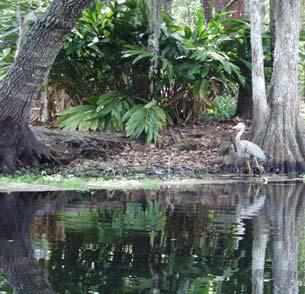
2 Lake Tohopekaliga Fish Management Area County: Osceola PCL Size: 18,810 acres Project ID: EC acres $171, Project Manager: Florida Fish & Wildlife Conservation Commission Bruce V. Jaggers 601 W. Woodward Avenue, Eustis, Florida Phone: , Fax: The Lake Toho project area comprised four work sites. The Shingle Creek floodplain site was dominated by mature stands of bald cypress (Taxodium distichum) and Chinese tallow; however, Chinese tallow was outcompeting native vegetation at this site. Shingle Creek drains the southwestern Orlando area and is one of the primary water inflows into Lake Toho. Approximately twelve acres of Chinese tallow occurred in the Shingle Creek Floodplain site as dense to moderately dense infestations. An estimated 0.5 acres of the trees were greater than 1.25 feet diameter breast height (DBH). Paradise Island had established Chinese tallow stands in both shoreline bald cypress/carolina willow (Salix caroliniana) stands as well as in one upland area. Makinson Island had scattered Chinese tallow and a small melaleuca hammock established primarily in shoreline bald cypress/carolina willow/red maple (Acer rubrum) stands. Chinaberry (Melia azedarach) grew primarily in upland habitats. Tropical soda apple (Solanum viarum) occurred in both shoreline and upland habitats. The southeast shoreline of Lake Toho had scattered Chinese tallow trees established in various native plant communities. Chinese tallow in the other work sites was scattered or in small groups of trees with each group being 0.25 acres or less. Chinaberry occurred as individuals or in small groves of trees 0.05 acres or less. Melaleuca consisted of one small hammock 0.01 acres in size. Tropical soda apple existed as individual plants in wetland areas and as clumps of dense plants 0.01 acres or less in upland habitats. Melaleuca quinquenervia melaleuca Category I girdle Garlon 4 Melia azedarach Chinaberry Category I basal Garlon 4 Solanum viarum tropical soda apple Category I foliar Garlon 4 Triadica sebifera Chinese tallow Category I basal Garlon 4 14 Wildlife also appreciate invasive plant control results.


3 From Chinese tallow seeds......to Chinese tallow seedlings... Lake Tohopekaliga green hatching on work sites...to a Chinese tallow thicket! 15
4 Lake Lizzie Nature Preserve County: Osceola PCL Size: 880 acres Project ID: EC acres $100,000 Project Manager: Osceola County Planning Department Rod Schultz, Public Lands Manager 1 Courthouse Square, Kissimmee, Florida Phone: , Fax: rsch@osceola.org Osceola County purchased the Lake Lizzie Nature Preserve (Preserve) with a Florida Communities Trust grant in July The Preserve consists of approximately 430 acres of uplands and 450 acres of wetlands. Natural communities include freshwater marsh, wet prairie, pine flatwoods, scrubby pine flatwoods, and xeric oak scrub. The wetlands were infested with primrose willow, Brazilian pepper, Caesar s weed, castor bean, and scattered camphor trees. Coverage approached sixty-five percent throughout the affected wetland areas. In the uplands, exotic species included downy rosemyrtle, bahiagrass (Paspalum notatum), bladderpod, Brazilian pepper, and dog fennel. Coverage was nearly twenty-five percent throughout the affected upland areas. Cinnamomum camphora camphor tree Category I basal/cut stump Garlon 4 Colocasia esculenta wild taro Category I basal Garlon 4 Dioscorea bulbifera air-potato Category I basal Garlon 4 Dioscorea bulbifera air-potato Category I foliar Glypro+Escort Eugenia uniflora Surinam cherry Category I basal/cut stump Garlon 4 Imperata cylindrica cogon grass Category I foliar Glypro+Chopper Lantana camara lantana Category I cut stump Garlon 4 Lantana camara lantana Category I foliar Glypro+Escort Lygodium japonicum Japanese climbing fern Category I basal/cut stump Garlon 4 Panicum repens torpedo grass Category I foliar Glypro+Escort Rhodomyrtus tomentosa downy rose-myrtle Category I basal/cut stump Garlon 4 Sapium sebiferum Chinese tallow Category I basal Garlon 4 Schinus terebinthifolius Brazilian pepper Category I basal/cut stump Garlon 4 Solanum viarum tropical soda apple Category I basal Garlon 4 Solanum viarum tropical soda apple Category I foliar Glypro+Escort Eppipremnum pinnatum pothos Category II cut stump Garlon 4 Ricinus communis castor bean Category II basal/cut stump Garlon 4 Sansevieria hyacinthoides bowstring hemp Category II cut stump Garlon 4 Syagrus romanzoffiana queen palm Category II basal/cut stump Garlon 4 Urena lobata Caesar s weed Category II basal Garlon 4 Urena lobata Caesar s weed Category II foliar Glypro+Escort Catharanthus roseus periwinkle n/a hand pull n/a 16


5 Dense downy rose-myrtle (left) and wild taro (right) terrorized land managers. 17

6 Shingle Creek Recreational Preserve County: Osceola PCL Size: 122 acres Project ID: EC acres $13, Project Manager: Osceola County Rod Schultz, Project Coordinator 1 Courthouse Square, Kissimmee, Florida Phone: , Fax: rsch@osceola.org Osceola County and the City of Kissimmee purchased a portion of the Shingle Creek Recreational Preserve with a Florida Communities Trust grant in April The Preserve, when fully purchased will be approximately 182 acres. The project area comprised approximately 88 acres of County/City land and approximately 34 acres of City land. The project area consisted of approximately 29 acres of upland pasture natural restoration and 93 acres of wetlands. The uplands are best characterized as abandoned pasture turned fallow. The wetlands are riverine bottomland swamp primarily dominated with bald cypress trees. Shingle Creek s shoreline banks and associated project area within the wetlands contained significant numbers of mature guava trees, Chinese tallow, Brazilian pepper, Caesar s weed, rattlebox, primrose willow, and scattered camphor tree. In the uplands, dominant plant species included bahiagrass, Chinese tallow, bladderpod, soda apple, Brazilian pepper, and dog fennel. This project consisted of maintenance control throughout the prior fiscal year s project area. Cinnamomum camphora camphor tree Category I basal Garlon 4 Colocasia esculenta wild taro Category I foliar Aquaneat Dioscorea bulbifera air-potato Category I foliar Aquaneat Psidium guajava guava Category I basal/cut stump Garlon 4 Sapium sebiferum Chinese tallow Category I basal/cut stump Garlon 4 Schinus terebinthifolius Brazilian pepper Category I basal Garlon 4 Sesbania punicea rattlebox Category II foliar Aquaneat Urena lobata Caesar s weed Category II foliar Aquaneat 18

7 19

8 Three Lakes Wildlife Management Area County: Osceola PCL Size: 61,845 acres Project ID: EC acres $25, Project Manager: Fish & Wildlife Conservation Commission Bryan Ames, Biological Scientist II 1231 Prairie Lakes Road, Kenansville, Florida Phone: , Fax: Three Lakes Wildlife Management Area is located in southern Osceola County along the eastern shore of Lake Kissimmee, and surrounding portions of Lakes Marian and Jackson. The WMA contains significant acreage of contiguous longleaf pine flatwoods, oak hammocks, cypress strands, and grassy wetlands, as well as over 12,000 acres of the globally imperiled dry prairie natural community. The property also supports one of peninsular Florida s largest red-cockaded woodpecker (Picoides borealis) populations, and a large population of Florida grasshopper sparrows (Ammodramus savannarum floridanus). Smaller numbers of Florida scrub jay (Aphelocoma coerulescens), Audubon s crested caracara (Caracara plancus audubonii), wood stork (Mycteria americana), and other species occur throughout the year. Several protected plants occur on the property, including the state threatened wild coco (Pteroglossapsis ecristata) and the state endangered manyflowered grasspink (Calopogon multiflorus). This project consisted of maintenance treatment on Brazilian pepper on two sites previously treated through BIPM funding. Brazilian pepper was mostly scattered in small discontinuous patches of low-density saplings and seedlings in marsh, upland, and shoreline areas of Lake Kissimmee. FWC contributed $4,700 of in-kind services to the project. Schinus terebinthifolius Brazilian pepper Category I basal/cut stump Garlon 4 20


9 21

10 Triple N Ranch Wildlife Management Area County: Osceola PCL Size: 16,673 acres Project ID: EC acres $5, Project Manager: Fish & Wildlife Conservation Commission Brandon Rutledge, Biological Scientist III 5600 Crabgrass Road, St. Cloud, Florida Phone: , Fax: brandon.rutledge@fwc.state.fl.us The Triple N Ranch WMA contains nearly 9,000 acres of mesic pine flatwoods and over 2,000 acres of contiguous cypress swamp, as well as nearly 700 acres of the globally imperiled dry prairie natural community. Other natural communities include wet prairie, depression marsh, xeric oak scrub, hardwood swamp, hardwood hammock, and hydric hammock. Fourteen rare plant species are known or suspected to occur on the WMA, including short-leaved rosemary (Conradina brevifolia) and wild coco (Pteroglossaspis ecristata). Cogon grass occurred inside an operational orange grove on the WMA and began to invade nearby mesic flatwoods. Cogon grass outside the grove was limited to small patches that totaled approximately five acres. BIPM provided the herbicide only for this project through its Herbicide Bank. Imperata cylindrica cogon grass Category I foliar Aquaneat+Arsenal Treatment areas (crosshatched) 22

 labor and funding built four trails through the park in the late 1930s. Until the early 1970s, a greenhouse containing Dr.")
11 Mead Garden County: Orange PCL Size: 55 acres Project ID: EC acres $10,820 Project Manager: City of Winter Park Public Works Department Tim Egan, Chief of Lakes 401 Park Avenue South, Winter Park, Florida Telephone: , Fax: Mead Garden was established in 1937 with the donation of several parcels of land that represented several different natural communities between Howell Creek and Denning Drive. Work Progress Administration (WPA) labor and funding built four trails through the park in the late 1930s. Until the early 1970s, a greenhouse containing Dr. Theodore Mead s collection of rare plants was located near the main entrance. Howell Creek, flowing from Lake Sue to Lake Virginia, forms the eastern border of the park. Natural communities represented in Mead Garden include hydric hammock, bay swamp, open meadow, and upland hardwood forest. Invasive exotic plants, especially air potato, skunk vine, and wild taro invaded the park about 15 years ago and occurred throughout the project area. The infestations were most extensive on the east side along the creek, with a sixty percent cover of invasive plants, and the north side including the bay swamp, with ninety percent coverage. The western and southern sides of the project area were lightly to moderately infested, with a thirty to sixty percent range of coverage primarily along borders of the site. BIPM funded control of the twelve most heavily infested acres. The City provided inkind services valued at $10,045 to control ten moderately invested acres adjacent to Howell Creek. Colocasia esculenta wild taro Category I foliar Roundup Dioscorea bulbifera air-potato Category I foliar Roundup Paederia foetida skunk vine Category I foliar Garlon 3A Exotic vines were overrunning the tree canopy at the Garden......while wild taro took over the understory. 23


12 Project Map for Mead Garden Time to weed the Garden! 24

13 Lake Lawne County: Orange PCL Size: 161 acres Project ID: EC acres $25,000 Project Manager: Florida Fish & Wildlife Conservation Commission Bruce V. Jaggers 601 W. Woodward Avenue, Eustis, Florida Phone: , Fax: Lake Lawne is a 156-acre water body located near the community of Pine Hills, an older Orlando suburb that was initially developed in the 1950s and 1960s. Barnett Park, an Orange County park adjacent to Lake Lawne, has a boat ramp that provides public access to the lake. Lake Lawne is unique for an urban lake in that a good portion of the shoreline (approximately 60%) is undeveloped or bordered by Orange County or City of Orlando park lands. The natural community in the project area was historically dominated by red maple (Acer rubrum), bald cypress (Taxodium distichum), swamp bay (Persea palustris), and wax myrtle (Myrica cerifera). Homeowners had planted Chinese tallow in their yards adjacent to the lake, so tallow was well established on all three sites in the project area. Brazilian pepper was established on one site only. All infestations were dense to moderately dense. Schinus terebinthifolius Brazilian pepper Category I basal Garlon 4 Triadica sebifera Chinese tallow Category I basal Garlon 4 Lake Lawne Work Sites 1-3 with green hatching delineating work areas. 25
14 Spring Hammock Preserve County: Seminole PCL Size: 1,500 acres Project ID: EC acres $41,250 Project Manager: Seminole County Natural Lands Program Gregg Walker, Senior Biologist 1101 East First Street, Sanford, Florida Phone: , Fax: Spring Hammock Preserve is located on the western shore of Lake Jesup. The Preserve encompasses much of the watershed for Soldier Creek, an important tributary to Lake Jesup. The Preserve possesses two threatened natural communities, sandhill and scrub. The Preserve also contains a variety of rare plants, including Florida willow, pygmy fringe tree, royal fern, cinnamon fern, and needle palm. Adjacent natural conservation lands include the Lake Jesup Wilderness Area and the Lake Jesup Conservation Area. Property acquisition on the Spring Hammock Preserve began in 1927 with the donation of Big Tree Park to Seminole County and acquisitions continued into the 1990s. Colocasia esculenta wild taro Category I foliar Roundup+Garlon 4 Dioscorea bulbifera air-potato Category I foliar Roundup+Garlon 4 Lygodium japonicum Japanese climbing fern Category I foliar Roundup+Garlon 4 Melia azedarach Chinaberry Category I basal Garlon 4 Nephrolepis cordifolia sword fern Category I foliar Roundup+Garlon 4 Paederia foetida skunk vine Category I foliar Roundup+Garlon 4 Solanum viarum tropical soda apple Category I foliar Roundup+Garlon 4 Syngonium podophyllum arrowhead vine Category I foliar Roundup+Garlon 4 Tradescantia fluminensis wandering Jew Category I foliar Roundup+Garlon 4 Sphagneticola trilobata wedelia Category II foliar Roundup+Garlon 4 Urena lobata Caesar s weed Category II foliar Roundup+Garlon 4 26

15 27

16 Lake Lotus Park County: Seminole PCL Size: 125 acres Project ID: EC acres $14, Project Manager: The City of Altamonte Springs Angie Woodall, Park Ranger 1153 Lake Lotus Park Road, Altamonte Springs, Florida Phone/Fax: Lake Lotus Park encompasses natural habitat ranging from pine scrub to floodplain wetlands. Three sites were targeted for invasive plant control, one each on the east and west bank of the Little Wekiva River, extending to a sandbar in Lake Lotus, and one site in a wetland area near the southwest region of the park. The east bank site included two acres with sixty-seven percent invasive plant coverage. The west bank site covered one acre with sixteen percent coverage. The wetland site comprised two acres with seven percent coverage. Colocasia esculenta wild taro Category I foliar Aquaneat Nephrolepis cordifolia sword fern Category I foliar Aquaneat Pennisetum purpureum elephant grass Category I foliar Aquaneat Urochloa mutica Pará grass Category I foliar Aquaneat Panicum maximum Guinea grass Category II foliar Aquaneat 28
17 Seminole County Natural Lands County: Seminole PCL Size: n/a (see below) Project ID: EC acres $4, Project Manager: Natural Lands Program Gregg Walker, Senior Biologist 1101 East First Street, Sanford, Florida Phone: , Fax: Approximately 7,000 acres have been purchased and are under management by the Seminole County Natural Lands Program (NLP). The NLP manages over a dozen different plant communities from open water and hydric hammock to threatened sandhill and scrub communities. County preserves also contain a variety of rare plants, including Florida willow, pygmy fringe tree, royal fern, cinnamon fern, needle palm, spikemoss, and many-flowered grasspink. With the exception of open water communities, exotics were treated in nearly all of the natural communities. Within land managed by the NLP, an estimated 550 acres (7.5%) were infested with invasive exotic plants. BIPM provided the herbicides only for this project through its Herbicide Bank. Ardisia crenata coral ardisia Category I basal Garlon 4 Cinnamomum camphora camphor tree Category I basal Garlon 4 Colocasia esculenta wild taro Category I basal Garlon 4 Dioscorea bulbifera air-potato Category I foliar Roundup Imperata cylindrica cogon grass Category I foliar Roundup Lantana camara lantana Category I basal Garlon 4 Lygodium japonicum Japanese climbing fern Category I foliar Roundup Melia azedarach Chinaberry Category I basal Garlon 4 Nephrolepis cordifolia sword fern Category I foliar Roundup Paederia foetida skunk vine Category I foliar Roundup Ruellia brittoniana Mexican petunia Category I foliar Roundup Schinus terebinthifolius Brazilian pepper Category I basal Garlon 4 Solanum viarum tropical soda apple Category I foliar Roundup Syngonium podophyllum arrowhead vine Category I foliar Roundup Tradescantia fluminensis wandering Jew Category I foliar Roundup Triadica sebifera Chinese tallow Category I basal Garlon 4 Broussonetia papyrifera paper mulberry Category II basal Garlon 4 Solanum diphyllum twinleaf nightshade Category II foliar Roundup Urena lobata Caesar s weed Category II foliar Roundup 29
Southwest Regional Working Group
 Southwest Regional Working Group The Southwest Regional Working Group liaison is Roger Clark, Lee County Parks and Recreation, 3410 Palm Beach Boulevard, Ft. Myers, Florida 33916, phone: 239-338-3343,
Mosquito Coast Regional Working Group
 Mosquito Coast Regional Working Group Merritt Island Invasive Exotic Plant Control Projects PCL: Merritt Island National Wildlife Refuge Project Manager: U.S. Fish and Wildlife Service Ron Hight, Refuge
Southwest Regional Working Group
 Southwest Regional Working Group The Southwest Regional Working Group liaison is Roger Clark, Lee County Parks and Recreation, 3410 Palm Beach Boulevard, Ft. Myers, Florida 33916, phone: 941-338-3343,
Southeast Regional Working Group
 Southeast Regional Working Group The Southeast Regional Working Group liaison is Joe Maguire, Miami-Dade Parks and Recreation, 22200 S.W. 137 th Avenue, Miami, Florida 33170, phone: 305-257-0933, fax:
Pinellas County Environmental Lands
 Pinellas County Environmental Lands In addition to traditional parks and recreation facilities, Pinellas County owns and manages a system of environmental lands that provides specialized resource-based
Frond Forum Florida Native Plant Society Cuplet Fern Chapter :: Seminole County
 Florida Native Plant Society Cuplet Fern Chapter :: Seminole County 2013 14 Board President: Beth Jackson Vice President: Sherry Williams Secretary: Christine Brown Treasurer: Susan Blount-Angermeier Chapter
MANAGEMENT STATUS REPORT FOR CONSERVATION 20/20 PRESERVES FY QUARTER 1 REPORT (October-December 2018) January 10, 2018
 January 10, 2018") CAPE CORAL, PINE ISLAND, SANIBEL and MATLACHA PASS AREAS Charlotte Harbor Buffer Preserve 448.61 acres adjacent to Charlotte Harbor Preserve State Park Nominations 58, 91, 95, 96, 99, 137, 262, 280, 372,
CAPE CORAL, PINE ISLAND, SANIBEL and MATLACHA PASS AREAS Charlotte Harbor Buffer Preserve 448.61 acres adjacent to Charlotte Harbor Preserve State Park Nominations 58, 91, 95, 96, 99, 137, 262, 280, 372,
Rock Creek State Park
 Rock Creek State Park Rock Creek State Park Rock Creek State Park, located five miles west of Grinnell, consists of a large man-made lake and a surrounding fringe of land. There are several access points
STORNETTA BROTHERS COASTAL RANCH
 STORNETTA BROTHERS COASTAL RANCH Location: Surrounding Point Arena Lighthouse and immediately south of Manchester State Park Mendocino Co., CA Acres: 1,860 Resources: Over two miles of Pacific Ocean coastline
SECTION 2. NATURAL RESOURCES. General
 SECTION 2. NATURAL RESOURCES General Brooker Creek Preserve is approximately 55% uplands and 45% wetlands. The upland areas are predominantly pine flatwoods with some areas of hammocks, sandhills, and
Conservation Lands. Conservation Lands Advisory Committee October 19, 2005
 Conservation Lands Advisory Committee October 19, 2005 Roland DeBlois Chief of Environmental Planning & Code Enforcement Community Development Department Beth Powell Conservation Lands Manager Parks Division
Brooker Creek Preserve Management Plan 2008 Update
 Brooker Creek Preserve Management Plan 2008 Update Plan approved by the Board of County Commissioners Pinellas County, Florida 19 August 2008 Pinellas County Department of Environmental Management Environmental
Wetlands Reservoirs of Biodiversity. Billy McCord, SCDNR
 Wetlands Reservoirs of Biodiversity Billy McCord, SCDNR Estuaries Tidal Deepwater Intertidal Salt Marsh Tidal Riverine Fresh & Brackish Deepwater Tidal Emergent Marsh Freshwater Riverine Seasonally Flooded
MANAGEMENT STATUS REPORT FOR CONSERVATION 20/20 PRESERVES QUARTER 1 REPORT (October - December 2017) February 8, 2018
 February 8, 2018") CAPE CORAL, PINE ISLAND, SANIBEL and MATLACHA PASS AREAS Charlotte Harbor Buffer Preserve 446 acres adjacent to Charlotte Harbor Preserve State Park Nominations 58, 91, 95, 96, 99, 137, 262, 280, 372,
CAPE CORAL, PINE ISLAND, SANIBEL and MATLACHA PASS AREAS Charlotte Harbor Buffer Preserve 446 acres adjacent to Charlotte Harbor Preserve State Park Nominations 58, 91, 95, 96, 99, 137, 262, 280, 372,
South Texas Plains. Texas, Our Texas
 South Texas Plains This is a region characterized by considerable variety. Climatically, the South Texas Plains region is sub-humid to dry. The in the north part of the South Texas, erosion of the Edwards
HAROLD E. ALEXANDER SPRING RIVER WILDLIFE MANAGEMENT AREA
 HAROLD E. ALEXANDER SPRING RIVER WILDLIFE MANAGEMENT AREA HAROLD E. ALEXANDER SPRING RIVER WILDLIFE MANAGEMENT AREA Prepared by: Randy Brents Jr (Fire Management Officer) Dallas Harrell (Area Biologist)
MANAGEMENT STATUS REPORT FOR CONSERVATION 20/20 PRESERVES QUARTER 3 REPORT (April-June 2016) August 11, 2016
 August 11, 2016") CAPE CORAL, PINE ISLAND, SANIBEL and MATLACHA PASS AREAS Charlotte Harbor Preserve 446 acres C20/20 Preserves adjacent to Charlotte Harbor Preserve State Park Nominations 58, 91, 95, 96, 99, 137, 262,
CAPE CORAL, PINE ISLAND, SANIBEL and MATLACHA PASS AREAS Charlotte Harbor Preserve 446 acres C20/20 Preserves adjacent to Charlotte Harbor Preserve State Park Nominations 58, 91, 95, 96, 99, 137, 262,
FLORIDA DEPARTMENT OF ENVIRONMENTAL PROTECTION DIVISION OF RECREATION AND PARKS RECREATIONAL CARRYING CAPACITY GUIDELINES
 FLORIDA DEPARTMENT OF ENVIRONMENTAL PROTECTION DIVISION OF RECREATION AND PARKS RECREATIONAL CARRYING CAPACITY GUIDELINES THE SELECTION AND CAPACITY DETERMINATION OF USE SITES Introduction The Division
Urban Weeds of The Coffs Harbour Local Government Area. By Aaron Hartley Bush Regeneration Officer Coffs Harbour City Council
 Urban Weeds of The Coffs Harbour Local Government Area By Aaron Hartley Bush Regeneration Officer Coffs Harbour City Council Introduction Coffs Harbour City Council Bush Regeneration Crew is funded by
Florida Department of Environmental Protection Division of Recreation and Parks
 Florida Department of Environmental Protection Division of Recreation and Parks Land Edward Ball Wakulla Springs State Park Introduction Edward Ball Wakulla Springs State Park is a 6,055.2-acre public
IOWA ORNITHOLOGISTS' UNION - Birding Sites in Dallas County
 IOWA ORNITHOLOGISTS' UNION - Birding Sites in Dallas County Printed on 7/19/2018 Beaver Bottoms Wetland (restricted) (Important Bird Area) GPS Coordinates:, Ownership: Private (see directions for access)
MANAGEMENT STATUS REPORT FOR CONSERVATION 20/20 PRESERVES QUARTER 3 REPORT (April - June 2018) July 12, 2018
 July 12, 2018") CAPE CORAL, PINE ISLAND, SANIBEL and MATLACHA PASS AREAS Charlotte Harbor Buffer Preserve 446 acres adjacent to Charlotte Harbor Preserve State Park Nominations 58, 91, 95, 96, 99, 137, 262, 280, 372,
CAPE CORAL, PINE ISLAND, SANIBEL and MATLACHA PASS AREAS Charlotte Harbor Buffer Preserve 446 acres adjacent to Charlotte Harbor Preserve State Park Nominations 58, 91, 95, 96, 99, 137, 262, 280, 372,
2.0 Physical Characteristics
 _ 2.0 Physical Characteristics 2.1 Existing Land Use for the Project The site is comprised of approximately 114 acres bounded by Highway 101 to the north, the existing town of Los Alamos to the east, State
CREW Cypress Dome Trails Self-Guided Tour
 CREW Cypress Dome Trails Self-Guided Tour The numbers in this guide correspond to numbers on the Cypress Dome Trail Map (included in this guide below) and to the brown number plates fastened to marker
Annual maintenance figures include areas that were re-treated in previous years, so the cumulative acreage is greater than the estimated total area
 1 Annual maintenance figures include areas that were re-treated in previous years, so the cumulative acreage is greater than the estimated total area infested. MANAGER COST ACRES Cities $501,169 1,201
Phoenix Habitat Restoration Projects
 Phoenix Habitat Restoration Projects Spur Cross Ranch Cave Creek (Estergard) Regional Tree and Shade Summit March 9, 2010 Desert Riparian Ecosystems Healthy riparian areas like this once existed along
IOWA ORNITHOLOGISTS' UNION - Birding Sites in Cerro Gordo County
 IOWA ORNITHOLOGISTS' UNION - Birding Sites in Cerro Gordo County Printed on 11/17/2018 Blue-wing Marsh GPS Coordinates: 43.0834956379463,-93.4430980682373 Pure natural area primarily used for hunting.
3.0 EXISTING PARK & RECREATION SPACE
 3.0 EXISTING PARK & RECREATION SPACE TOWN PARK & RECREATION SPACE An inventory of current parks and recreation area in the Town of Cedarburg is shown in Table 3. These areas total roughly 381.89 acres.
Bratt ") 4. % F l o r i d a D e s i g n a t e d P a d d l i n g T r a i l s ") 164 «97 ") 99. Barrineau Park. M a p 1. M a p 2.
 4. % F l o r i d a D e s i g n a t e d P a d d l i n g T r a i l s ) 164 «97 ) 99. Barrineau Park. M a p 1. M a p 2.") F l o r i d a D e s i g n a t e d P a d d l i n g T r a i l s Bratt ") 4 Bluff Springs «4 Jay ") P e r d i d o R i v e r P e r d i d o CR R99A i v Walnut e r Hill ") 164 ") 97A «89 «97 ") 197 Barrineau
F l o r i d a D e s i g n a t e d P a d d l i n g T r a i l s Bratt ") 4 Bluff Springs «4 Jay ") P e r d i d o R i v e r P e r d i d o CR R99A i v Walnut e r Hill ") 164 ") 97A «89 «97 ") 197 Barrineau
Our Mission. Discover the many states of California. Chino Hills State Park 1879 Jackson Street Riverside, Ca (951)
") Chino Hills State Park Our Mission The mission of the California Department of Parks and Recreation is to provide for the health, inspiration and education of the people of California by helping to preserve
Chino Hills State Park Our Mission The mission of the California Department of Parks and Recreation is to provide for the health, inspiration and education of the people of California by helping to preserve
March Hello everyone,
 Hello everyone, March 2015 Our first trip of 2015 found us at the Santee National Wildlife Refuge. It was sunny most of the day with highs in the low 50s and a steady breeze that made it feel much cooler.
Map 1.1 Wenatchee Watershed Land Ownership
 Map 1.1 Wenatchee Watershed Land Ownership Map 1.1 Wenatchee Watershed Land Ownership The Wenatchee watershed lies in the heart of Washington state in Chelan County. Just larger than the state of Rhode
This Passport: Revised October 20, 2017, EAM # Discovering the Trails of Webster, NY
 This Passport: Revised October 20, 2017, EAM #161923 Discovering the Trails of Webster, NY The Town of Webster invites you to explore and experience our diverse outdoor adventures! Here s your opportunity
Forever Wild Program Acquisitions CURRENT AS OF 1/4/2017
 Forever Wild Program Acquisitions CURRENT AS OF 1/4/2017 1. THE MONSANTO TRACT in Marshall County consists of 209 acres of donated mountainous, pine-hardwood covered peninsula on Lake Guntersville that
Forever Wild Program Acquisitions (Tract Values at Time of Purchase) CURRENT AS OF 1/28/2019
 CURRENT AS OF 1/28/2019") Forever Wild Program Acquisitions (Tract Values at Time of Purchase) CURRENT AS OF 1/28/2019 1. MONSANTO TRACT in Marshall County consists of 209 acres of donated mountainous, pine-hardwood covered peninsula
Forever Wild Program Acquisitions (Tract Values at Time of Purchase) CURRENT AS OF 1/28/2019 1. MONSANTO TRACT in Marshall County consists of 209 acres of donated mountainous, pine-hardwood covered peninsula
$850,000 Awarded to 20 Organizations
 $850,000 Awarded to 20 Organizations The Conservation Alliance is pleased to fund the following organizations to support their efforts to protect wild lands and waterways for their habitat and recreation
Acquisition in fee simple of approximately one-half acre of property on the shore of Spring Lake to expand the Lakeside Beach Park.
 Lakeside Beach TF00-136 $122,550.00 in fee simple of approximately one-half acre of property on the shore of Spring Lake to exp the Lakeside Beach. 2000 River Ravines TF00-150 $910,000.00 in fee simple
NOTICE OF INTENT MAPS WITH DESCRIPTIONS
 NOTICE OF INTENT MAPS WITH DESCRIPTIONS Location Map(s) to Accompany Notice of Intent The small corner map embedded in the lower left corner of the large map above shows the location of the three national
Florida Department of Environmental Protection Division of Recreation and Parks
 Florida Department of Environmental Protection Division of Recreation and Parks Land Honeymoon Island State Park Introduction Honeymoon Island State Park is a 2,810.16-acre public outdoor recreation and
Spatial Distribution and Characteristics of At-Risk Species in the Southeast U.S.
 Nicholas Institute for Environmental Policy Solutions Scoping Document Part 2 Exploratory Analysis of Characteristics and Trends of At-Risk Species in the Southeast U.S. Spatial Distribution and Characteristics
proof Northwest District
 1 Northwest District The Northwest Florida Water Management District is the most rural of all five water management districts. From just east of Tallahassee west to the Florida/Alabama line, and from the
Atchafalaya River and Bayous Chene, Boeuf, and Black, LA Disposal Area I Inspection. CEMVN-OD-T August 2011
 Atchafalaya River and Bayous Chene, Boeuf, and Black, LA Disposal Area I Inspection CEMVN-OD-T August 2011 Overview The CEMVN conducted an inspection of Disposal Area I on 4-August-2011 to investigate
Lynde Creek Watershed. Lynde Creek Watershed CLOCA LYNDE CREEK WATERSHED EXISTING CONDITIONS REPORT CHAPTER 1 STUDY AREA
 Lynde Creek Watershed CLOCA Lynde Creek Watershed CLOCA LYNDE CREEK WATERSHED EXISTING CONDITIONS REPORT CHAPTER 1 STUDY AREA June 2008 TABLE OF CONTENTS 1.0 STUDY AREA... 3 1.1 Lynde Main Subwatershed...6
DOYLE SPRINGS PLANNING UNIT Kern-Tule River Watershed
 Existing Conditions & Uses Overview Consists of a mostly forested parcel with small hydropower developments and part of a private recreation cabin development, along with two small transmission line corridor
David Magney Environmental Consulting
 David Magney Environmental Consulting DELINEATION OF JURISDICTIONAL WATERS AND RIPARIAN HABITATS FOR LYONS CANYON RANCH, NEWHALL, CALIFORNIA Prepared for: UNITED STATES ARMY CORPS OF ENGINEERS and CALIFORNIA
B10. Agate Beach State Recreation Site
 B10. Agate Beach State Recreation Site Location Within the City of Newport, just south of the Yaquina Head Outstanding Natural Area. The park is located along the west side of Highway 101 at the mouth
MCARTHUR SWAMP PLANNING UNIT Pit-McCloud River Watershed
 Existing Conditions & Uses Overview Spring-fed lake and rivers; valuable grazing lands and important waterfowl area Planning unit provides the only public access to Ahjumawi Lava Springs State Park 7,596
Prepared by Cathy Quinlan & Brad Hertner Upper Thames River Conservation Authority. For the City of Woodstock
 Prepared by Cathy Quinlan & Brad Hertner Upper Thames River Conservation Authority For the City of Woodstock Burgess Park and Standard Tube Parks in the west end of Woodstock Pittock Reservoir Along the
SOUTH WALTON TRAILWAYS
 SOUTH WALTON TRAILWAYS 13 14 15 10 1 2 11 12 3 5 6 4 3 7 9 8 Nestled throughout Walton County are 200 miles of hiking and biking trails winding through state forests, state parks and public-private greenways.
THE FLORIDA TRAIL ASSOCIATION. Congressional Report. Trail Operations Report
 THE FLORIDA TRAIL ASSOCIATION Congressional Report 2017 Trail Operations Report 1 Like on Facebook: facebook.com/floridatrailassociation Follow on Twitter: twitter.com/floridatrail See on Instagram: instagram.com/floridatrail
Classifications, Inventory and Level of Service
 Classifications, Inventory and Level of Service Section 3 Kenmore Park, Recreation and Open Space Plan 1 P a g e Classifications and Inventory Park Classifications Kenmore classifies its parks based upon
Daisy Dean Trail 628/619 ATV Trail Construction
 Background and Purpose and Need The Daisy Dean ATV Trail Construction Project is located in the Little Belt Mountains, Musselshell Ranger District, Lewis and Clark National Forest approximately 32 miles
DEVELOPMENT LAND FOR SALE
 centrally LOCATED! Minutes from WALT DISNEY WORLD! Lake Louisa INCREDIBLE LOCATION Located on east side of US 27 approx. 2 miles south of Clermont in Lake County, FL. SIZE 721± acres Seller will divide.
THOMAS A. SWIFT METROPARK Introductions History Present Conditions Future Development Plans Implementation Strategies Statistics
 THOMAS A. SWIFT METROPARK Introductions History Present Conditions Future Development Plans Implementation Strategies Statistics Introduction As an open meadow park positioned along the Mahoning River,
Chapter 2: Summary of Existing Open Space System
 Chapter 2: Summary of Existing Open Space System In 1976, the Wake County Board of Commissioners established the Wake County Parks and Recreation Department in order to provide park facilities and programs
Conservation Area Management Statement
 Conservation Area Management Statement Miller Creek Wildlife Area Resolution #: Approval: Issue Date: Date of Last Revision: Table of Contents 1. Purpose....... 1 2. Property Description...... 1 2.1. Legal
Ragged Mountain Natural Area. Public Planning Meeting #1 February 29 th, 2016
 Ragged Mountain Natural Area Public Planning Meeting #1 February 29 th, 2016 Planning During dam construction P&R approached by various groups asking if the rules would be changed once the dam was complete
 MANAGEMENT STATUS REPORT FOR CONSERVATION 20/20 PRESERVES July 2012 (April 1 June 30) July 2012 CAPE CORAL, PINE ISLAND, and MATLACHA PASS AREAS Charlotte Harbor Preserve 400 acres C20/20 Preserves adjacent
The Croatan MST Segment 16B
 1 Mountains-to-Sea Trail Last Updated 1/1/2017 A sandy road through longleaf pine savanna in the Croatan National Forest Photo by PJ Wetzel, www.pjwetzel.com The Croatan MST Segment 16B STELLA TO THE NEUSIOK
X. WHATCOM CREEK SMA. X.1 Watershed Analysis. X.1.1 Landscape Setting
 X. WHATCOM CREEK SMA Summary: The entire length of Whatcom Creek is located within the City of Bellingham. SMA jurisdiction associated with this creek is approximately 300 acres. Land use is dominated
PASSPORT. Discovering the Trails of Webster, NY
 PASSPORT to family wellness Discovering the Trails of Webster, NY Join the Friends of Webster Trails, Webster Health and Education Network, The Town of Webster and Wegmans to get moving more and enjoy
U.S. Army Corps of Engineers Fiscal Year 2013 Handshake Program Application
 U.S. Army Corps of Engineers Fiscal Year 2013 Handshake Program Application Please review instructions before completing application! Corps Lake/Project Name:Rathbun Lake/ North Shore Trail Handshake Proposal
BIRDING Lake Fayetteville
 BIRDING Lake Fayetteville Lake Fayetteville is an impoundment of Clear Creek, created as a water supply for Fayetteville in 1949. With development of other water supplies, especially Beaver Lake, Lake
Maya s Creek Crossing Hwy 17 N acres $185,000 Fort Davis, Texas
 Maya s Creek Crossing Hwy 17 N 14.98 acres $185,000 Fort Davis, Texas James King, Agent Office 432-426-2024 Cell 432-386-2821 James@KingLandWater.com King Land & Water LLC P.O. Box 109, 600 State Street,
KETTLE CREEK CONSERVATION AUTHORITY TRAIL GUIDE.
 KETTLE CREEK CONSERVATION AUTHORITY TRAIL GUIDE www.kettlecreekconservation.on.ca EXPLORE OUR TRAILS HIKE OUR TRAILS Kettle Creek Conservation Authority (KCCA) proudly supports and promotes an active lifestyle
DATE: January 19, WCA Governing Board. Johnathan Perisho, Project Manager. Mark Stanley, Executive Officer
 Item 14 DATE: January 19, 2017 TO: FROM: THROUGH: SUBJECT: WCA Governing Board Johnathan Perisho, Project Manager Mark Stanley, Executive Officer Item 14: Consideration of a resolution to accept an acquisition
SRC 2010: JUNGLE BINGO Words
 SRC 2010: JUNGLE BINGO Words B Adventure B Ape B Binoculars B Boa Constrictor B Camp B Canteen B Cougar B Danger B Ecosystem B Elephant B Forest B Guides B Habitat B Jeep B King B Knife B Madagascar B
Land Protection Accomplishments
 2017 Land Protection Accomplishments Conserving Open Space and Recreational Access On the Pacific Crest National Scenic Trail View from the Pacific Crest Trail of Donomore Meadows near the California/Oregon
Ex-Situ Conservation Site at Assam State Zoo cum Botanical Garden
 Ex-Situ Conservation Site at Assam State Zoo cum Botanical Garden The Government of India, in order to combat the adverse effects of climate change on the Himalayan states of India, introduced the National
PRIORITY HABITAT SURVEY 2017 SWALEDALE. Summary. July 2018
 PRIORITY HABITAT SURVEY 2017 SWALEDALE Summary July 2018 Conservation & Monitoring Report No: Lead Author(s): Tony Serjeant & Sue Thurley Incorporating comments from: Gary Smith & Gordon Haycock (16/07/18)
Southwest Quadrant Distinctive Features
 SOUTHWEST QUADRANT Southwest Quadrant Distinctive Features LAND USE The 31.17 square mile Southwest Quadrant includes all the area within the planning area west of I-5 and south of the Sacramento River.
Lewis and Clark National Historic Trail
 National Trails System Land and Water Conservation Fund FY2014 Lewis and Clark National Historic Trail Total LWCF Request: $ 3,130,000 Project Name Agency District # Tracts Acres Total Cost Columbia River
Conservation of Critical Environmental Resources in Chatham Park
 Conservation of Critical Environmental Resources in Chatham Park Elaine Chiosso, Haw Riverkeeper Haw River Assembly Haw River As Seen From Chatham Park "Spreading southwestward from the banks of the Haw
National Forests and Grasslands in Texas
 United States Department of Agriculture Forest Service National Forests and Grasslands in Texas Sam Houston NF 394 FM 1375 West New Waverly, Texas 77358 Phone 936-344-6205 Dear Friends, File Code: 1950
BA Collaborators. Driftless Area Initiative The Prairie Enthusiasts Trout Unlimited TNC TCF Natural Resources Foundation of Wisconsin
 BA Collaborators Driftless Area Initiative The Prairie Enthusiasts Trout Unlimited TNC TCF Natural Resources Foundation of Wisconsin The mission of the of the Blufflands Alliance is to actively conserve
DIXIE HIGHWAY Region of Peel NAI Area # 1304, 1320, 2449, 2625, 3961
 DIXIE HIGHWAY 407 1 Region of Peel NAI Area # 1304, 1320, 2449, 2625, 3961 Toronto and Region Conservation Authority City of Brampton Size: 36 hectares Watershed: Etobicoke Creek Con 4 E, Lots 13, 14 Ownership:
Town of Oakfield Agricultural and Farmland Protection Plan
 SECTION III COMMUNITY OVERVIEW A. Regional Setting / Location The Town of Oakfield is located in the northwestern portion of Genesee County. Located west of New York's Finger Lakes, the Town is uniquely
KOOTENAY LAKE PROVINCIAL PARK (MIDGE CREEK SITE)
") KOOTENAY LAKE PROVINCIAL PARK (MIDGE CREEK SITE) PURPOSE STATEMENT AND ZONING PLAN February 2003 Approved by: KOOTENAY LAKE PROVINCIAL PARK (Midge Creek Site) Purpose Statement and Zoning Plan Primary
KOOTENAY LAKE PROVINCIAL PARK (MIDGE CREEK SITE) PURPOSE STATEMENT AND ZONING PLAN February 2003 Approved by: KOOTENAY LAKE PROVINCIAL PARK (Midge Creek Site) Purpose Statement and Zoning Plan Primary
Biodiversity is life Biodiversity is our life
 Biodiversity is life Biodiversity is our life Chapter 10 Section 2 Biodiversity at Risk Objectives Define and give examples of endangered and threatened species. Describe several ways that species are
Blanco Creek Ranch Acres, Uvalde County, Texas
 Blanco Creek Ranch 1208.30 Acres, Uvalde County, Texas James King, Agent Office 432 426.2024 Cell 432 386.2821 James@KingLandWater.com Blanco Creek Ranch 1208.30 acres Uvalde County, Texas James King,
DEVELOPMENT LAND FOR SALE
 Lake Louisa 51± Planned Commercial 249± acres Proposed Wellness Center 152± acres Proposed 600 Single-Family Lots FOR SALE: 44± acres Planned Commercial/ Multi-Family FOR SALE: 231± gross acres (120± net
DREDGED MATERIAL DISPOSAL HISTORY AVOCA ISLAND LAKE
 DREDGED MATERIAL DISPOSAL HISTORY AVOCA ISLAND LAKE The Atchafalaya River & Bayous Chene, Boeuf, & Black, Louisiana, project was authorized by the Rivers and Harbors Act of 1968, House Document 155, 90
MINIMUM REQUIREMENTS DECISION GUIDE WORKSHEETS
 ARTHUR CARHART NATIONAL WILDERNESS TRAINING CENTER MINIMUM REQUIREMENTS DECISION GUIDE WORKSHEETS Fuel Maintenance Around Red-cockaded Woodpecker Trees on Islands within the Okefenokee Wilderness Area....
4988 +/- ACRES JEFFERSON AND LEON COUNTY, FLORIDA
 4988 +/- ACRES JEFFERSON AND LEON COUNTY, FLORIDA Located in the famed Red Hills of north Florida, El Destino Plantation consists of 4988+/- acres and represents an incredible opportunity to own one of
USDA Forest Service Deschutes National Forest DECISION MEMO. Round Lake Christian Camp Master Plan for Reconstruction and New Facilities
 USDA Forest Service Deschutes National Forest DECISION MEMO Round Lake Christian Camp Master Plan for Reconstruction and New Facilities Jefferson County, Oregon T. 13 S., R. 8 E., Section 16, W.M. Background:
Skyland Ranch. At a Glance: Property Features
 Property Features Ideally positioned in an ox box of the mighty Apalachicola River, Skyland Ranch s 2 ½ miles of river frontage form the foundation of this distinctive property. Coveted by recreational
Quintessential Rare Plant Site Protected, Forever Celebrating the New Wilsons Lake Conservation Lands
 Quintessential Rare Plant Site Protected, Forever Celebrating the New Wilsons Lake Conservation Lands A hotspot for Canadian endangered species conservation has been protected, forever, in Nova Scotia.
(Short Listing) DUPUYER ACREAGE, ROCKY MOUNTAN FRONT
 DUPUYER ACREAGE, ROCKY MOUNTAN FRONT") (Short Listing) DUPUYER ACREAGE, ROCKY MOUNTAN FRONT This unique property is located 8½ miles northwest of Dupuyer, Montana and approximately thirty 30 miles northwest of Choteau, Montana. Great Falls
(Short Listing) DUPUYER ACREAGE, ROCKY MOUNTAN FRONT This unique property is located 8½ miles northwest of Dupuyer, Montana and approximately thirty 30 miles northwest of Choteau, Montana. Great Falls
Segment 2: La Crescent to Miller s Corner
 goal of the USFWS refuges is to conserve, protect and enhance fish, wildlife and plants and their habitats for the continuing benefit of the American people. Refuge lands are used largely for fishing,
THE AIRPORT Situated on approximately 3,000 acres, Orlando Sanford International Airport (SFB) boasts the finest leisure passenger facilities in the
 boasts the finest leisure passenger facilities in the") THE AIRPORT Situated on approximately 3,000 acres, Orlando Sanford International Airport (SFB) boasts the finest leisure passenger facilities in the United States. The airport is conveniently located within
THE AIRPORT Situated on approximately 3,000 acres, Orlando Sanford International Airport (SFB) boasts the finest leisure passenger facilities in the United States. The airport is conveniently located within
Northeast Quadrant Distinctive Features
 NORTHEAST QUADRANT Northeast Quadrant Distinctive Features LAND USE The Northeast Quadrant includes all the area within the planning area that is east of Interstate 5 and to the north of State Route 44.
Appendix C. Tenderfoot Mountain Trail System. Road and Trail Rehabilitation Plan
 Appendix C Tenderfoot Mountain Trail System Road and Trail Rehabilitation Plan All rehabilitation work would be under the direction of the District Fisheries Biologist, the Forest Hydrologist, and/or the
II. GENERAL DESCRIPTION OF ENVIRONMENTAL SETTING
 II. GENERAL DESCRIPTION OF ENVIRONMENTAL SETTING A. LOCATION AND BOUNDARIES The proposed Canyon Hills project site is located at 8000 West La Tuna Canyon Road in the City of Los Angeles (the City ). The
F.O.K.O.S. Friends of Kingston Open Space A GUIDE TO KINGSTON OPEN SPACE
 F.O.K.O.S. Friends of Kingston Open Space A GUIDE TO KINGSTON OPEN SPACE Friends of Kingston Open Space (FOKOS) was formed when a handful of concerned citizens joined together to learn what could be done
Niagara Natural Heritage Park
 A Future Proposal For the Niagara-on-the-Lake DND Lands....... Parks Canada Lakeshore Road Property 1 May, 2016 The Harmony Residents Group We are proposing a Natural Heritage Park be established on the
Pine Swamp Wildlife Corridor
 AVALONIA LAND CONSERVANCY, Inc. P.O. Box 49, Old Mystic, CT 06372 Phone 860-884-3500 Send email to avalonialc@yahoo.com Website: http://www.avalonialandconservancy.org. Pine Swamp Wildlife Corridor Property
Region 1 Piney Woods
 Region 1 Piney Woods Piney Woods 1. This ecoregion is found in East Texas. 2. Climate: average annual rainfall of 36 to 50 inches is fairly uniformly distributed throughout the year, and humidity and temperatures
Wow! Have you seen our new website! Same address: gctrust.org, great new look!
 Wow! Have you seen our new website! Same address: gctrust.org, great new look! Your donation to the GCT helps us manage over 1500 acres of conservation lands, protecting valuable habitat and creating recreational
Decision Memo Ice Age Trail Improvement (CRAC 37)
") Decision Memo Ice Age Trail Improvement (CRAC 37) U.S. Forest Service Chequamegon-Nicolet National Forest, Medford-Park Falls Ranger District Taylor County, Wisconsin T32N, R2W, Town of Grover, Section
Decision Memo Ice Age Trail Improvement (CRAC 37) U.S. Forest Service Chequamegon-Nicolet National Forest, Medford-Park Falls Ranger District Taylor County, Wisconsin T32N, R2W, Town of Grover, Section
Hudson Bay Lowlands Proposed Protected Areas
 Hudson Bay Lowlands Proposed Protected Areas Hudson Bay Lowlands Proposed Protected Areas The Protected Areas Initiative has identified portions of the Hudson Bay Lowlands region that have significant