PROSPECCIÓN ARQUEOLÓGICA A TRAVÉS DE LIDAR Y ORTOFOTOGRAMETRIA EN EL TAJÍN, VERACRUZ
|
|
|
- Theodore Reeves
- 5 years ago
- Views:
Transcription
1 PLAN DE MANEJO INTEGRAL DE LA ZONA DE MONUMENTOS RQUEOLOGICOS EL TAJIN PROSPECCIÓN ARQUEOLÓGICA A TRAVÉS DE LIDAR Y ORTOFOTOGRAMETRIA EN EL TAJÍN, VERACRUZ Archaeological Survey through LiDAR and Orthophotogrammetry In Archaeological Zone of El Tajín, Veracruz; México cdra. Guadalupe Zetina Gutiérrez Responsable del SIG y la Investigación con Sensores Remotos Dra. Patricia Castillo Peña Directora Académica de El Tajín Responsable del Campo de Manejo Investigación Geospatial Latinamerican Forum Cd. de México 24 de Septiembre de 2014
2 BACKGROUND Part of Research based of Remote Sensing directed by Dr. Patricia Castillo Part of Plan of Management of this Archaeological Zone

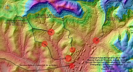
3 Location of El Tajín, Northern Veracruz; México
4 Oneof the most important zoneof exploration and exploitation of hydrocarbons


5 Oil/urbanization threatening sites on the Gulf Coast of Mexico Vulnerability by location Looting TRADITIONAL METHODOLOGIES ARE INSUFFICIENTLY FAST TO RECORD AND PROTECT


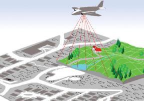
6 REMOTE SENSING Photogrammetry Satelite Imagery Laser Scann Remote sensing transforming the way cultural patrimony is being recorded

 of Archaeological Zone")
7 Location of El Tajín sprotected polygon of km 2 Last topographic map ( ) of Archaeological Zone of El Tajín, before of LiDAR
8 THE RESEARCH S PROJECT
9 Prospección Arqueológica Tradicional 1. Los Recursos Económicos y Humanos Disponibles 2. El Diseño de la Prospección (muestreo) 3. Definición de variables que afectan la prospección (accesos, condiciones sociales, ecológicas, etc.)


10 Photogrametry Remote Sensing in El Tajín (Castillo Peña, 2011) Termography LiDAR Cover a wide area quickly and identify, record, preserve and study all buildings inside protected area to better comprenhension of inner dynamics Determine if there are structural damage to main buildings due oil exploration and natural disasters like flooding and earthquakes
11 Objetives of Research 1. Identify and record all archaeological remains inside of polygon of protection of archaeological zone 2. Know parts and characteristics of ancient settlement of El Tajín 3. Design Long-term preservation and research strategies and study of Monuments within the Zone 4. Develop better oficialregulations to preserve and manage cultural proprieties in collaboration with municipalities and the government and people.
12 TAKING OF DATA
 GNSS")

13 Table 1. Comparative general of taking of LiDAR s data Equipment to previous terrestrial activities a) GNSS Leica GS09 receiver, b) GPS Leica ATX900 antenna, and c) Total Station Leica TS02 Comparative of set of data s LiDAR Area km km 2 (a) Beggining of labors End of labors 07-may jul de enero 2014 Total of control points (GNSS) Point density(m2)

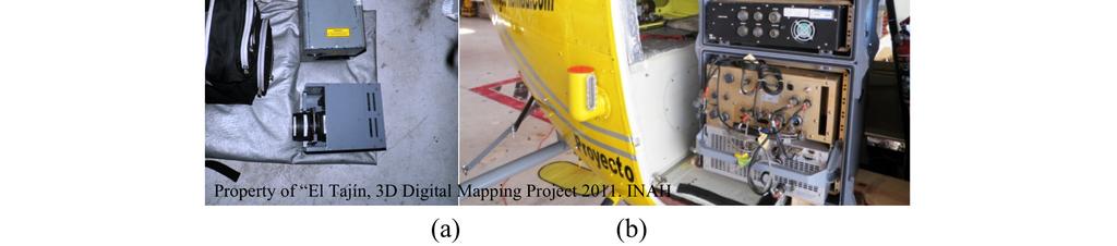

14 LiDAR Scanner and parameters
15 mera Contax to taking aerial photographs and become them in ortho-rectified Property of El Tajín, 3D Digital Mapping Project 2011 Photogrammetric Camera and parameters
16 PROCESSING OF DATA OF LiDAR AND PHOTOGRAMMETRY

17 Processing of LiDAR


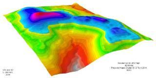
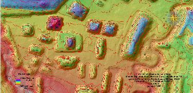
18 Filtering of cloud of points by heights, returns, and typesin Mars Software

19 Processing of composition of Maps
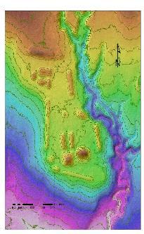
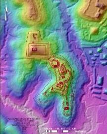
20 REMOTE ARCHAEOLOGICAL SURVEY
21 Process of Remote Archaeological Survey

22
23

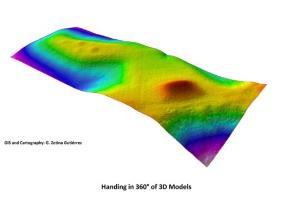
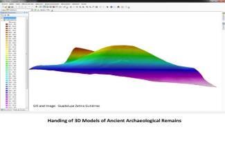
24 TIN 3D Model 3D Models
25 RESULTS AND CONCLUSIONS
26 Advantages of use in our research inside this ancient settlement are: 1. Represents a nondestructive technique and a precise, faster and efficient way to identify, record, research and preserve archaeological remains. 2. The velocity of identification and recording is at least ten times faster 3. Focus not on isolated sites or isolated architectural remains but instead entire landscapes 4. we can describe and understand better the distributions and parts of archaeological settlements 5. Allowed us to build an inventory so that we could monitor archaeological sites to facilitate public policies regarding archaeological conservation 6. We have better criteria to designate excavation areas in better way than the traditional methods. 7. Allow us create more effective strategies to protect sites with the data collected from digital mapping. Zetina Gutiérrez, Fisher and Castillo, On Press RemoteSensingJournal, Special Issue New Perspectives, of Remote Sensing for Archaeology
27 Specific results 1. Development of methodology to remote archaeological survey 2. Recorder of more of documented 91 new archaeological structures. 3. Topography in detail. 4. Hydrological model derived from LiDAR 5. We identify paths, roads and routes. Zetina Gutiérrez, Fisher and Castillo, On Press RemoteSensingJournal, Special Issue New Perspectives, of Remote Sensing for Archaeology
28
29 GRACIAS! THANK YOU!
KKC can provide the total solution from Data capturing to Consulting
 Crowdsource Mapping Response to the Great East Japan Earthquake Kunihiro ISHII kunihiro_ishii@kk-grp.jp Business Fields of KOKUSAI KOGYO(KKC) KKC can provide the total solution from Data capturing to Consulting
UAS to GIS Utilizing a low-cost Unmanned Aerial System (UAS) for Coastal Erosion Monitoring
 for Coastal Erosion Monitoring") UAS to GIS Utilizing a low-cost Unmanned Aerial System (UAS) for Coastal Erosion Monitoring Agenda Scope of today s presentation Demonstration Objectives Wrightsville Beach Test Area Masonboro Inlet Jetties
UAS to GIS Utilizing a low-cost Unmanned Aerial System (UAS) for Coastal Erosion Monitoring Agenda Scope of today s presentation Demonstration Objectives Wrightsville Beach Test Area Masonboro Inlet Jetties
Preparedness and Rapid Response based on Geospatial Information at Great East Japan Earthquake in 2011
 Preparedness and Rapid Response based on Geospatial Information at Great East Japan Earthquake in 2011 Akira Doi Executive Officer Kokusai Kogyo Co., Ltd. Taken by Kokusai Kogyo UNISDR UNISDR is the United
Using LiDAR for Precise Vegetation Management
 Using LiDAR for Precise Vegetation Management Quantum Spatial is a proven partner to airport planners, engineers, facility managers, and contractors whose objective is to build, expand, and make improvements
Ground Deformation Monitoring at Natural Gas Production Sites using Interferometric SAR
 Ground Deformation Monitoring at Natural Gas Production Sites using Interferometric SAR By: Kanika Goel, Robert Shau, Fernando Rodriguez Gonzalez, Nico Adam Remote Sensing Technology Institute (IMF), German
RISING PERFORMANCE. Civil aviation is an outlier. It s BY ERIK DAHLBERG
 RISING PERFORMANCE Compact mobile mapping systems can be installed on small passenger cars. Civil aviation is an outlier. It s among the few industries where tight government regulations are widely accepted
Applying Geospatial Tools to Produce Data for SDG Indicators in Mexico
 Applying Geospatial Tools to Produce Data for SDG Indicators in Mexico Inter-Agency and Expert Group On SDGs Indicators Enrique Ordaz Francisco J. Jimenez Stockholm November 2018 Background INEGI has produced
GEOMATIC ASSESSMENT Membership Directory & Buyers Guide 97th Annual Conference Recap WINTER 2017/18
 WINTER 2017/18 GEOMATIC NC AWWA-WEA 3725 National Drive, Suite 217 Raleigh, NC 27612 ADDRESS SERVICE REQUESTED 2018 Membership Directory & Buyers Guide 97th Annual Conference Recap The official publication
DRONING FOR INFORMATION
 DRONING FOR INFORMATION Opportunity of Drones for Surveying and Mapping Practices By: Adam Smith, CP Matt Aguirre, PLS Overview Introduction Background Problem and Opportunity Issues and Mitigations Implementation
AUGUST 2017 GNSS REVIEW. Survey Economics Chances of success. Mobile Mapping Airport scanning. Stag s Leap Winery Pre-construction plan
 AUGUST 2017 GNSS REVIEW Survey Economics Chances of success Stag s Leap Winery Pre-construction plan Mobile Mapping Airport scanning RISING PERFORMANCE» ERIK DAHLBERG Civil aviation is an outlier. It s
* Head of the UNESCO-ICOMOS Documentation Centre.
 UNESCO-ICOMOS Documentation Centre: A specialized bibliographic resource on built heritage Jose Garcia Vicente* 1. Introduction * ICOMOS, the International Council on Monuments and Sites, is an association
Environmental Development of River Road Ranch
 Environmental Development of River Road Ranch New Braunfels, Texas Alix Scarborough GEO 3426 April 2012 Introduction The 2,400-acre Word-Borcher ranch has been owned by the Word family since 1941. Located
Using Geospatial Data in the Oil & Gas Industry. Dr. Stacey D. Lyle, RPLS
 Using Geospatial Data in the Oil & Gas Industry Dr. Stacey D. Lyle, RPLS Outcomes A Geospatial Data Science Center is an advanced database of information organized and accessible using multiple software
TERMS OF REFERENCE (Revision 9) Special Committee (SC) 213 Enhanced Flight Vision Systems/Synthetic Vision Systems
 Special Committee (SC) 213 Enhanced Flight Vision Systems/Synthetic Vision Systems") REQUESTOR: RTCA Paper No. 349-16/PMC-1568 TERMS OF REFERENCE (Revision 9) Special Committee (SC) 213 Enhanced Flight Vision Systems/Synthetic Vision Systems Organization Federal Aviation Administration,
REQUESTOR: RTCA Paper No. 349-16/PMC-1568 TERMS OF REFERENCE (Revision 9) Special Committee (SC) 213 Enhanced Flight Vision Systems/Synthetic Vision Systems Organization Federal Aviation Administration,
Satellite Imagery Briefing: Monitoring Endangered Cultural Heritage Sites
 Satellite Imagery Briefing: Monitoring Endangered Cultural Heritage Sites Early Warning and Threat Monitoring System for Cultural Heritage Sites in the Developing World March 2011 Endangered Global Heritage
UNMANNED AIRCRAFT SYSTEMS (UAS) IN UTILITIES
 IN UTILITIES") UNMANNED AIRCRAFT SYSTEMS (UAS) IN UTILITIES Presented by: Dan Carbone Avion Unmanned Why Drones? Why Drones? Cost Effective Entire cost of a UAS program can be recouped in first-year man-hour savings
UNMANNED AIRCRAFT SYSTEMS (UAS) IN UTILITIES Presented by: Dan Carbone Avion Unmanned Why Drones? Why Drones? Cost Effective Entire cost of a UAS program can be recouped in first-year man-hour savings
Launching a New Surveying Perspective
 Launching a New Surveying Perspective >> By Mary Jo Wagner A 3 km2 orthomosaic shows the entire construction site and surroundings. On the upper part of the mosaic are the Bristol Channel; the existing
GEOSPATIAL ANALYSIS OF GLACIAL HAZARDS PRONE AREAS OF SHIGAR AND SHAYOK BASINS OF PAKISTAN. By Syed Naseem Abbas Gilany
 GEOSPATIAL ANALYSIS OF GLACIAL HAZARDS PRONE AREAS OF SHIGAR AND SHAYOK BASINS OF PAKISTAN By Syed Naseem Abbas Gilany PRESENTATION OUTLINE Introduction Problem Statement / Rationale Objectives Material
Drones in Construction: Beyond Pictures Capturing and Exploring Actionable Data
 Drones in Construction: Beyond Pictures Capturing and Exploring Actionable Data Hunter Cole & Jesse Creech Virtual Design + Construction Brasfield & Gorrie General Contractors Join the conversation #AU2016
LAUNCHING YOUR UNMANNED AIRCRAFT PROGRAM
 LAUNCHING YOUR UNMANNED AIRCRAFT PROGRAM THE DARTDRONES TEAM UNMANNED AIRCRAFT APPLICATIONS AERIAL INSPECTIONS AERIAL INSPECTIONS Safer and faster alternative to visual inspection by an individual Damage
along a transportation corridor in
 Rockfall hazard and risk assessment along a transportation corridor in the Nera Valley, Central Italy Presentation on the paper authored by F. Guzzetti and P. Reichenbach, 2004 Harikrishna Narasimhan Eidgenössische
Ohio UAS Center - Enabling Flight 2016 Ohio Planning Conference Fred Judson, GISP UAS Program Director
 Ohio UAS Center - Enabling Flight 2016 Ohio Planning Conference Fred Judson, GISP UAS Program Director Fred.Judson@dot.state.oh.us How It Began (For Me) Formalization of GIS in the district. Implementation
Digital twin for life predictions in civil aerospace
 Digital twin for life predictions in civil aerospace Author James Domone Senior Engineer June 2018 Digital Twin for Life Predictions in Civil Aerospace Introduction Advanced technology that blurs the lines
Partial Report. Project Leader: Nicolás Lagos. Executive Summary
 Partial Report Understanding the relationship between the Andean cat and its habitat in the high Andes plateau: Implications for its long term conservation Project Leader: Nicolás Lagos Executive Summary
USE OF 3D GIS IN ANALYSIS OF AIRSPACE OBSTRUCTIONS
 USE OF 3D GIS IN ANALYSIS OF AIRSPACE OBSTRUCTIONS A project by by Samuka D. W. F19/1461/2010 Supervisor; Dr D. N. Siriba 1 Background and Problem Statement The Airports in Kenya are the main link between
Budi Hadi Narendra Harris Herman Siringoringo Chairil Anwar Siregar. Research and Development Center for Forest
 Budi Hadi Narendra Harris Herman Siringoringo Chairil Anwar Siregar Research and Development Center for Forest Background Coastal management should be wisely done as a part of watershed management. Typologically,
CRYOSPHERE NEPAL. BIKRAM SHRESTHA ZOOWA Sr. Hydrologist Department of Hydrology and Meteorology NEPAL 2016
 CRYOSPHERE NEPAL BIKRAM SHRESTHA ZOOWA Sr. Hydrologist Department of Hydrology and Meteorology NEPAL 2016 ORGANISATIONAL STRUCTURE Ministry of Science, Technology and Environment DEPARTMENT OF HYDROLOGY
UAV systems for cultural heritage HERICT ERASMUS IP Technical lecture 2
 UAV systems for cultural heritage HERICT ERASMUS IP Technical lecture 2 Dr. Dimitrios Skarlatos Lecturer Cyprus university of Technology Photogrammetric Vision Lab Dept. of Civil Eng. & Geomatics Dipl.
The Potentially Dangerous Glacial Lakes
 Chapter 11 The Potentially Dangerous Glacial Lakes On the basis of actively retreating glaciers and other criteria, the potentially dangerous glacial lakes were identified using the spatial and attribute
Geospatial Data Collection for the FAA Airports GIS Program
 Geospatial Data Collection for the FAA Airports GIS Program A Change in Direction Dr. Michael T. McNerney, P.E. FAA Office of Airports Office of Airport Safety and Standards Assistant Manager, Airport
Lidar Imagery Reveals Maine's Land Surface in Unprecedented Detail
 Maine Geologic Facts and Localities December, 2011 Lidar Imagery Reveals Maine's Land Surface in Unprecedented Detail Text by Woodrow Thompson, Department of Agriculture, Conservation & Forestry 1 Introduction
New measurements techniques
 2 nd Asia CryoNetWorkshop New measurements techniques Xiao Cunde (SKLCS/CAS and CAMS/CMA) Feb.5, 2016, Salekhard, Russia Outline Definition of New Some relative newly-used techniques in China -- Eddy covariance
Tourism development in fast growing heritage cities: positive force, or threatening agent?
 Tourism development in fast growing heritage cities: positive force, or threatening agent? The case of Tatarstan in the Russian Federation 1 st IIPT European Conference. Leeuwarden, The Netherlands. October
Regional implementation of Electronic Terrain and Obstacle data (e-tod) (Presented by Jeppesen)
 (Presented by Jeppesen)") International Civil Aviation Organization SAM/IG/13-WP/39 South American Regional Office 5/04/14 Thirteenth Workshop/Meeting of the SAM Implementation Group English only (SAM/IG/13) - Regional Project
International Civil Aviation Organization SAM/IG/13-WP/39 South American Regional Office 5/04/14 Thirteenth Workshop/Meeting of the SAM Implementation Group English only (SAM/IG/13) - Regional Project
UNITED NATIONS EDUCATIONAL, SCIENTIFIC AND CULTURAL ORGANIZATION CONVENTION CONCERNING THE PROTECTION OF THE WORLD CULTURAL AND NATURAL HERITAGE
 World Heritage Distribution limited 27 COM WHC-03/27.COM/INF.13 Paris, 23 June 2003 Original : English/French UNITED NATIONS EDUCATIONAL, SCIENTIFIC AND CULTURAL ORGANIZATION CONVENTION CONCERNING THE
Recapturing the Spatial Dynamics of the Venetian Occupation Period
 Recapturing the Spatial Dynamics of the Venetian Occupation Period of Merabello in Eastern Crete through a GIS Approach MARIANNA KATIFORI'-^ ' University of Crete, Dept. of History & Archaeology and Dept.
Activity of Faculty of Technical Science in Realization GPS Permanent Stations Networks
 Activity of Faculty of Technical Science in Realization GPS Permanent Stations Networks Prof Miro Govedarica, PhD Faculty of Technical Science Novi Sad Center for Geoinformation Technologies and Systems
1. Universidad Nacional Autónoma de México 2. Centro de Investigación Científica y de Educación Superior de Ensenada
 SEA LEVEL MEASUREMENTS IN MEXICO Elaborated by: Jorge Zavala-Hidalgo 1 and Cuauhtémoc Nava 2 1. Universidad Nacional Autónoma de México 2. Centro de Investigación Científica y de Educación Superior de
How to Use Drones in Stormwater Management January 17, :30 a.m. 11:30 a.m. (Eastern)
") Webinar Training Series How to Use Drones in Stormwater Management January 17, 2019 10:30 a.m. 11:30 a.m. (Eastern) www.seswa.org Today s Presenters Robert Gecy Application Programmer Beaufort County,
Webinar Training Series How to Use Drones in Stormwater Management January 17, 2019 10:30 a.m. 11:30 a.m. (Eastern) www.seswa.org Today s Presenters Robert Gecy Application Programmer Beaufort County,
Observations of glacier dynamics with PALSAR DATA
 Observations of glacier dynamics with PALSAR DATA Tazio Strozzi, Urs Wegmüller and Charles Werner Gamma Remote Sensing, Gümligen, Switzerland Rhodes, Greece, 3 to 7 November 2008 Outline ESA GLOBGLACIER
Robson Valley Avalanche Tract Mapping Project
 Robson Valley Avalanche Tract Mapping Project Prepared for: Chris Ritchie Ministry of Water Land and Air Protection 325 1011 4th Avenue Prince George, BC. V2L3H9 and Dale Seip Ministry of Forests 1011
Unmanned Aerial Systems for Agriculture
 Unmanned Aerial Systems for Agriculture by Bob Schultheis Natural Resource Engineering Specialist for Greene County Soils & Crops Conference Springfield, MO March 18, 2014 Special thanks to Bill Wiebold,
What is a UAS (Drone)
") UAS KCSI Aerial Patrol KCSI is Based in Bakersfield CA Established in 1993 Operates in 15 States KCSI has over 20 fulltime pilots Currently fly: Over 40,000 miles of pipeline a month 700 hours of production
UAS KCSI Aerial Patrol KCSI is Based in Bakersfield CA Established in 1993 Operates in 15 States KCSI has over 20 fulltime pilots Currently fly: Over 40,000 miles of pipeline a month 700 hours of production
Integrated Applications Programme (IAP) & Space for UAS UAS for Applications
 & Space for UAS UAS for Applications") ESA s Integrated Applications Programme (IAP) & Space for UAS UAS for Applications M. Vaissiere ESA Director of Telecommunications and Integrated Applications Programme European High Level UAS Conference
ESA s Integrated Applications Programme (IAP) & Space for UAS UAS for Applications M. Vaissiere ESA Director of Telecommunications and Integrated Applications Programme European High Level UAS Conference
Summary of the study Marked paths and sustainable rural development
 1 Summary of the study Marked paths and sustainable rural development 2 Index Introduction 3 Who has made the study 4 Which are the trails studied 5 Conclusions 6 3 1. Introduction The paths keep alive
Ciudad Perdida, Colombia Project Progress Report
 Ciudad Perdida, Colombia 2012 Project Progress Report Executive Summary 2012 was another successful and exciting year of progress in and around the site of Ciudad Perdida in the Santa Marta Mountains of
Committee. Presentation Outline
 CW-33-15 11/9/2015 Community and Corporate Services Committee November 10, 2015 1 Presentation Outline Background Vision and Objectives Study Process and Timeline Public and Stakeholder Engagement Organization
Presentation: UAS Helicopter Waran -1-
 Presentation: UAS Helicopter Waran -1- The unique design features of the Waran provide a superior payload capacity, prolonged endurance, stable flight patterns and a high degree of safety features. Technical
COLOMBIAN SPACE COMMISSION: AN STRATEGY FOR THE SUSTAINABLE DEVELOPMENT OF COLOMBIA
 UN Committee on the Peaceful Uses of Outer Space: 2011 - Fifty-fourth fourth session COLOMBIAN SPACE COMMISSION: AN STRATEGY FOR THE SUSTAINABLE DEVELOPMENT OF COLOMBIA Iván n Darío o Gómez G Guzmán General
Platform and Products
 International Partnership Space Programme Earth Observation for the Preservation of Ecological Bacalar Corridor Platform and Products Terri Freemantle, Raffaella Guida, Paula Marti, Pasquale Iervolino
CASE STUDIES FROM ASIA
 AGRI-TOURISM Sustainable Tourism in GIAHS Landscapes CASE STUDIES FROM ASIA GIAHS Scientific and Steering Committee FAO Rome April 2014 Kazem Vafadari kazem@apu.ac.jp GIAHS-TOURISM Agritourism / Agrotourism
Opportunities arising for national economies from the valorisation of underwater cultural heritage though a sustainable development strategy
 Opportunities arising for national economies from the valorisation of underwater cultural heritage though a sustainable development strategy Lluís ABEJEZ Pere IZQUIERDO Jordi TRESSERRAS Facultat de Geografia
A Drone s Eye View on Public Works Applications
 A Drone s Eye View on Public Works Applications APWA Construction Inspection Conference Parker, CO Jason Caldwell, VP of Business Development and Sales 2013, The Sanborn Map Company, Inc. Agenda Sanborn
Remote Sensing into the Study of Ancient Beiting City in North-Western China
 Dingwall, L., S. Exon, V. Gaffney, S. Laflin and M. van Leusen (eds.) 1999. Archaeology in the Age of the Internet. CAA97. Computer Applications and Quantitative Methods in Archaeology. Proceedings of
The Exploration Foundation s 2011 Archaeological Field School in Honduras at the Formative Period Center of Yarumela
 The Exploration Foundation s 2011 Archaeological Field School in Honduras at the Formative Period Center of Yarumela July 9 th -Aug 12 2011 This field school offers students the opportunity to participate
Implementation of PBN in Armenian airspace
 Implementation of PBN in Armenian airspace PBN implementation plan, based on the specifications of the airspace of the Republic of Armenia, has been developed in accordance with Resolution A36-23, approved
Peak?» Rachel Schowe. Displayed with permission The American Surveyor April 2014 Copyright 2014 Cheves Media
 New Record for Southeast Asia s Highest Peak?» Rachel Schowe ince 1925, the people of Myanmar have been taught from an early age that the highest peak in all of Southeast Asia was the great Mount Hkakabo
OPERATIONAL EVALUATION OF UNMANNED AIRCRAFT SYSTEMS FOR CRASH SCENE RECONSTRUCTION
 AOS-17-0078 January 2017 OPERATIONAL EVALUATION OF UNMANNED AIRCRAFT SYSTEMS FOR CRASH SCENE RECONSTRUCTION Operational Evaluation Report Version 1.0 Prepared for: National Institute of Justice Prepared
Lake Chapala Dra. Raquel Gutiérrez Nájera Location 1
 Lake Chapala Dra. Raquel Gutiérrez Nájera Location Administrative Division The hydrological region formed by Lerma and Santiago rivers constitute a natural hydrologic river basin which covers an area of
The SESAR Airport Concept
 Peter Eriksen The SESAR Airport Concept Peter Eriksen EUROCONTROL 1 The Future Airport Operations Concept 1.1 Airports The aim of the future airport concept is to facilitate the safe and efficient movement
Mapping with Unmanned Airborne Systems (UAS)
") Mapping with Unmanned Airborne Systems (UAS) February 13, 2014 Engineering Architecture Design-Build Surveying GeoSpatial Solutions Today s Agenda Introductions / Objectives Current UAS Regulations (FAA)
Mapping with Unmanned Airborne Systems (UAS) February 13, 2014 Engineering Architecture Design-Build Surveying GeoSpatial Solutions Today s Agenda Introductions / Objectives Current UAS Regulations (FAA)
Towards a Swiss Rescue Robotics Team
 Davide Scaramuzza - University of Zurich rpg.ifi.uzh.ch Towards a Swiss Rescue Robotics Team Davide Scaramuzza University of Zurich Robotics and Perception Group rpg.ifi.uzh.ch My Research Background Davide
USGS Methods of Collecting High Water Marks (HWMs)
") USGS Methods of Collecting High Water Marks (HWMs) A. Thomas Ruby III Supervisory Hydrologist Indiana-Kentucky Water Science Center U.S. Department of the Interior U.S. Geological Survey Outline: Overview
USGS Methods of Collecting High Water Marks (HWMs) A. Thomas Ruby III Supervisory Hydrologist Indiana-Kentucky Water Science Center U.S. Department of the Interior U.S. Geological Survey Outline: Overview
International Conference on Economic Management and Trade Cooperation (EMTC 2014)
") International Conference on Economic Management and Trade Cooperation (EMTC 2014) A Study on the Changing Trends of Domestic Tourism Consumption Composition of Urban Residents Grouped by Travel Purpose
International Conference on Economic Management and Trade Cooperation (EMTC 2014) A Study on the Changing Trends of Domestic Tourism Consumption Composition of Urban Residents Grouped by Travel Purpose
Northern Mongolia Archaeology Project
 Northern Mongolia Archaeology Project A RIVER IN THE DARKHAD DEPRESSION NEAR THE SITE OF THE NORTHERN MONGOLIA ARCHAEOLOGY PROJECT Need a little adventure in your life? Interested in traveling to Mongolia?
Glasgow - a Collaborative Future
 Glasgow s Smart City Journey Glasgow - a Collaborative Future Iain Langlands - F.R.I.C.S. GIS Manager Land and Environmental Services, Glasgow City Council 30 January 2018 OFFICIAL Slide 1 Glasgow s Smart
Connecting Sava River. Tihomir L. Divjak
 Connecting Sava River Tihomir L. Divjak Baseline Sava River Basin is an unstable hydrological system Smart and sustainable development of Sava River Basin must be provided Definitions are given in the
UAS Unmanned Aircra: Systems in Forest Management
 UAS Unmanned Aircra: Systems in Forest Management UAS What are they? Unmanned Aircra: Systems (UAS) fill niche built upon military UAV technologies Most common plahorms Fixed Wing Rotorcra: Primary uses
ONE PLATFORM, MULTIPLE APPLICATIONS: SURVEYING CONSTRUCTION FORESTRY AGRICULTURE ENVIRONMENT POWER ENGINEERING BIRDIE YOUR TAILOR-MADE UAV
 UAV BIRDIE BIRDIE YOUR TAILOR-MADE UAV ONE PLATFORM, MULTIPLE APPLICATIONS: SURVEYING CONSTRUCTION FORESTRY AGRICULTURE ENVIRONMENT POWER ENGINEERING BIRDIE UAV is the complete mapping solution, made for
Degree in Business Administration and Management
 TYPES OF CLASSES : Theory class or lecture PA: Practical class PL: Practical class at the computer lab Each group can be divided in up to two PA groups (, PA2) Each group can be divided in up to four PL
Airport Systems: Planning, Design, and Management
 Airport Systems: Planning, Design, and Management Richard de Neufville AmedeoR. Odoni McGraw-Hill New York Chicago San Francisco Lisbon London Madrid Mexico City Milan New Delhi San Juan Seoul Singapore
Digitization of cultural landscape in Castile and Leon (Spain)
") Digitization of cultural landscape in Castile and Leon (Spain) Carlos Rodríguez Fernández Researcher architect LABPAP Architectural, Heritage and Cultural Landscape. University of ValladolidValencia I
Digitization of cultural landscape in Castile and Leon (Spain) Carlos Rodríguez Fernández Researcher architect LABPAP Architectural, Heritage and Cultural Landscape. University of ValladolidValencia I
KTRK Flight Tracking System, VNOMS, Altitudes and Positional Calculations
 KTRK Flight Tracking System, VNOMS, Altitudes and Positional Calculations Prepared by: Joseph A. LaMacchia August 17, 2015 Proprietary Information 1 Noise Complaint Details VNOMS Data and Flight Path Flight
High Precision Mapping From Long Endurance UAS. Gabe Ladd 4/10/14
 High Precision Mapping From Long Endurance UAS Gabe Ladd 4/10/14 Outline Test Missions Flown UAS Used For This Project Direct Mapping System Payload Data produced April 10, 2014 2014 American Aerospace
Benefits of CNS/ATM Implementation for the Region
 Benefits of CNS/ATM Implementation for the Region IATA today www.iata.org 227 Airline Members from 143 countries accounting for 94% of total international traffic 200 partners Representation in 90 countries
HILL-FORTS OF THE INNER TAY ESTUARY PERTH. Phase One PERTH AND KINROSS. Archaeological Survey Report. Oxford Archaeology North.
 HILL-FORTS OF THE INNER TAY ESTUARY PERTH PERTH AND KINROSS Phase One Archaeological Survey Report Oxford Archaeology North September 2012 Issue No: 2012-13/11322 OAN Job No: L10492a NGR: NO 182 153, NO
Coverage of Mangrove Ecosystem along Three Coastal Zones of Puerto Rico using IKONOS Sensor
 Coverage of Mangrove Ecosystem along Three Coastal Zones of Puerto Rico using IKONOS Sensor Jennifer Toledo Rivera Geology Department, University of Puerto Rico, Mayagüez Campus P.O. Box 9017 Mayagüez,
PBN/TF/7 DRAFT Appendix D to the Report D-1
 DRAFT STATUS OF IMPLEMENTATION TASKS LIST PBN Task Force C4/1 The APAC PBN TF encourages States to consider the GO Team visit. On-going. States are encouraged to consider the GO Team visit as required.
What is an Marine Protected Area?
 Policies, Issues, and Implications of Marine Protected Areas Kara Anlauf University of Idaho Before the House Subcommittee on Fisheries Conservation, Wildlife and Oceans April 29, 2003 What is an Marine
ICAO Big Data Project ADS-B Data as a source for analytical solutions for traffic behaviour in airspace
 ICAO Big Data Project ADS-B Data as a source for analytical solutions for traffic behaviour in airspace ICAO/IATA/CANSO PBN/2 San Jose December 8, 2016 Big Data process Quantitative Quantitative / Qualitative
Airspace Encounter Models for Conventional and Unconventional Aircraft
 Airspace Encounter Models for Conventional and Unconventional Aircraft Matthew W. Edwards, Mykel J. Kochenderfer, Leo P. Espindle, James K. Kuchar, and J. Daniel Griffith Eighth USA/Europe Air Traffic
THE SAN JUAN RIVER BASIN PROJECT
 Formulation of a Strategic Actions Program for the Integrated Management of the Hydrological Resources and Sustainable Development of the San Juan River Basin and its Coastal zone PROCUENCA SAN JUAN THE
ADAPT2DC PP5 Ústí Region
 ADAPT2DC PP5 Ústí Region Kick off meeting Erfurt, DE 19/1/2012 1 Ústí Region, Czech Republic 2 Border region Saxony, hardly affected by demographic changes after 2nd World War Mining region Energy producer
ANNUAL REPORT: ANCIENT METHONE ARCHAEOLOGICAL PROJECT 2014 FIELD SCHOOL
 ANNUAL REPORT: ANCIENT METHONE ARCHAEOLOGICAL PROJECT 2014 FIELD SCHOOL Director(s): Co- Director(s): Professor Sarah Morris, Cotsen Institute of Archaeology, UCLA John K. Papadopoulos, Cotsen Institute
THE REAPPEARANCE OF THE DANTON
 THE REAPPEARANCE OF THE DANTON MV Geo Prospector Operations In December 2007, the Fugro survey vessel Geo Prospector was performing part of the Detailed Marine Survey for routing the proposed Galsi gas
Members of the El Péñón Ecological Society monitoring birds, this helped with the scientific information.
 Using Strategic Alliances to Achieve International Designations of Priority Sites: Case of Laguna Cabral in Dominican Republic Yvonne Arias, Grupo Jaragua Rafael Lorenzo, Grupo Ecologista Tinglar José
Preliminary Results from the ATHENA-OAWL Venture Tech Airborne Mission
 Preliminary Results from the ATHENA-OAWL Venture Tech Airborne Mission Sunil Baidar (a, b), Sara Tucker (c), Mike Hardesty (a, b) (a) CIRES, University of Colorado Boulder, Boulder, CO (b) NOAA Earth System
Unmanned Aircraft System (UAS): regulatory framework and challenges. NAM/CAR/SAM Civil - Military Cooperation Havana, Cuba, April 2015
: regulatory framework and challenges. NAM/CAR/SAM Civil - Military Cooperation Havana, Cuba, April 2015") Unmanned Aircraft System (UAS): regulatory framework and challenges NAM/CAR/SAM Civil - Military Cooperation Havana, Cuba, 13 17 April 2015 Overview Background Objective UAV? Assumptions Challenges Regulatory
Unmanned Aircraft System (UAS): regulatory framework and challenges NAM/CAR/SAM Civil - Military Cooperation Havana, Cuba, 13 17 April 2015 Overview Background Objective UAV? Assumptions Challenges Regulatory
CRYOSPHERE ACTIVITIES IN SOUTH AMERICA. Bolivia. Summary
 WORLD METEOROLOGICAL ORGANIZATION GLOBAL CRYOSPHERE WATCH (GCW) CryoNet South America Workshop First Session Santiago de Chile, Chile 27-29 October 2014 GCW-CNSA-1 / Doc. 3.1.2 Date: 20 October 2014 AGENDA
Heritage Tourism { Benefits and Challenges for Municipalities
 Heritage Tourism { Benefits and Challenges for Municipalities Why Heritage Tourism? Sustainable Tourism Makes use of existing assets Beneficial to residents and visitors alike Attracts quality not quantity
3.6 Surveillance Data Exchange Activities. (Presented by the United States of America) SUMMARY
 SUMMARY") NACC/WG/2 - IP/08 International Civil Aviation Organization 22/04/08 North American, Central American and Caribbean Office Second North American, Central American and Caribbean Working Group Meeting (NACC/WG/2)
NACC/WG/2 - IP/08 International Civil Aviation Organization 22/04/08 North American, Central American and Caribbean Office Second North American, Central American and Caribbean Working Group Meeting (NACC/WG/2)
Sea Level Stations Operation in Nicaragua
 Sea Level Stations Operation in Nicaragua 1. Date of report: March 3, 2018 2. Title: Report of Sea Level Station Operations in NICARAGUA 3. Author of Report: Martha Herrera Jiménez INETER-Geophysics Direction
Planning and Policy Tourism Vice Ministry Sustainable Tourism Planning Direction General International Expert Workshop on Biodiversity Mainstreaming
 Planning and Policy Tourism Vice Ministry Sustainable Tourism Planning Direction General International Expert Workshop on Biodiversity Mainstreaming 17-19 November 2015 Mexico City 1 Planning and Policy
Formal verification of small and micro UAS
 Formal verification of small and micro UAS Prof Sandor M Veres University of Sheffield December 2, 2015 Introduction The purpose of my talk What to Verify? What are the models and requirements? Verification
Historic City of Ayutthaya
 Flood Risk Mitigation of Historic City of Ayutthaya ICOMOS-NL, PROTECTING DELTAS : HERITAGE HELPS! Rotterdam, the Netherlands, 24 September 2014 Hatthaya Siriphatthanakun Fine Arts Department, Ministry
Paper Reference. Paper Reference(s) 1312/4H Edexcel GCSE Geography A Higher Tier. Wednesday 15 June 2005 Afternoon Time: 1 hour 15 minutes
 1312/4H Edexcel GCSE Geography A Higher Tier. Wednesday 15 June 2005 Afternoon Time: 1 hour 15 minutes") Centre No. Candidate No. Paper Reference 1 3 1 2 4 H Surname Paper Reference(s) 1312/4H Edexcel GCSE Geography A Higher Tier Paper 4H Wednesday 15 June 2005 Afternoon Time: 1 hour 15 minutes Signature
Centre No. Candidate No. Paper Reference 1 3 1 2 4 H Surname Paper Reference(s) 1312/4H Edexcel GCSE Geography A Higher Tier Paper 4H Wednesday 15 June 2005 Afternoon Time: 1 hour 15 minutes Signature
AGAZINE DECEMBER 2015/JANUARY 2016
 M IDWEST FLYER AGAZINE DECEMBER 2015/JANUARY 2016 Published For & By The Midwest Aviation Community Since 1978 midwestflyer.com Unmanned Aircraft Systems Technology Creating New Perspectives That Will
Edgar Eduardo Sacayon Beyond the Evident Fine Art Infrared Photography Portafolio to be exhibited at Photokina, Germany.
 Edgar Eduardo Sacayon Beyond the Evident Fine Art y Portafolio to be exhibited at Photokina, Germany. FLAAR Foundation for Latin American Anthropological Research edsacayon@gmail.com Phone: (502) 5203-9132
MANUAL OF SUSTAINABILITY POLICIES. Hotel Lomas del Volcán 2018
 MANUAL OF SUSTAINABILITY POLICIES Hotel Lomas del Volcán 2018 Table of Contents Introduction.... 3 Objetive..... 4 Scope..... 4 4 Use..... 4 Validity.... 5 Hotel Lomas del Volcán.... 6 Mision.... 6 Vision.....
The most innovative knowledge platform for hoteliers
 The most innovative knowledge platform for hoteliers WHAT IS / Hotelier Academy Hotelier Academy is the new web platform created to spread knowledge and inspiration to global hoteliers. The platform provides