Custom House Quay. Produced by the South West Coast Path Team with support from:
|
|
|
- Richard Benson
- 5 years ago
- Views:
Transcription


1


2


.")
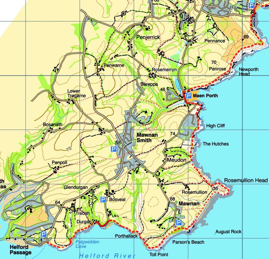
3 harbour. Shipbuilding began in 1878, and during the early to mid twentieth century further wharves were built, while Dry Dock Number Two was enlarged in 1958, being opened by HRH Prince Philip and renamed the Queen Elizabeth Dock. There is a viewpoint on the pavement above the docks, and a toposcope indicating the layout of the dry docks, wharves and workshops which are spread out below. 5 Carry on along Castle Drive, past the docks, until you come to the T-junction. 6 Turn right here, continuing across the roundabout and under the railway bridge. (There is no access to the seafront here, as the marina area is privately owned). Continue ahead on Bar Road as it curves inland and then sweeps to the right to continue in the original direction. Keep going forward as it becomes Avenue Road and heads past the National Maritime Museum (open daily throughout the year). Pendenni s Point Custom House Quay A Swanvale mouse Walks on and around the from Maenporth Estate Falmouth Docks Walk A tour of some of the historical features of the British Empire's second most important port, with its coastal artillery defences, the docks built after more than 16 thousand vessels visited in a nine-year period, and the Custom House Quay where the famous packet ships carried the post. A mostly level walk on pavements and good paths, with one steep hill to climb. Carry on past the Custom House and then St George's Arcade, Falmouth's first cinema, built in 1912 and one of Britain's largest at the time. Falmouth's famous packet ships arrived at and departed from Custom House Quay, which from the seventeenth century was the only place in Britain where the foreign post came in and out. Bullion was carried too on these small, fast two-masted brigs, as well as important passengers and some secret government intelligence. Other useful information Transport information: Western Greyhound Bus number 500 travels frequently from Truro via Falmouth to Helford Passage, stopping at Swanpool Beach. For details visit or phone Toilets: Swanpool and Gyllyngvase Beaches. 7 When you come to Killigrew Street, to your left at the end of Market Street, turn left onto it and follow it gently uphill, bearing left at the roundabout and continuing straight ahead past roads to left and right as the hill becomes steeper and finally meets the main A39 at the top. Car parks:pendennis Point, Gyllyngvase Seafront and Beach, Swanpool Beach. Refreshments:Swanpool and Gyllyngvase beach cafes and restaurants, seasonal. Falmouth all year round. Useful websites: ; National Maritime Museum Turn left here and walk about a hundred yards, to pick up the footpath opposite, along Marlborough Avenue, passing under the railway line to come out on Silverdale Road. Carry on along the footpath straight ahead. 9 Take the left fork through the trees for a short distance, forking left again to emerge again on Silverdale Road. 10 Turn right here, and then left onto Swanpool Hill,to pick up Madeira Walk on your right. Continue to the flight of steps towards the end, leading downhill to your right, and bear left at the bottom to return to the car park at Swanpool. Produced by the South West Coast Path Team with support from: Distance: Estimated time: Difficulty: Starting point: 5 miles/8 km from Swanpool Beach Car Park 2½ hours Moderate Swanpool Beach Car Park (Payment needed) SW Text and photos by Ruth Luckhurst The European Agricultural Fund for Rural Development: Europe Investing in rural areas This is one of the many walks that can be found at

4 Directions By car or on foot leave Maenporth Estate, turn left up Maenporth Road. After about ½ mile, turn right into Swanpool road. Follow this road all the way down to Swanpool Beach. The car park is on your left. The 500 bus stops at Maenporth and goes towards Falmouth, stopping at Swanpool Beach. 1 From the car park at Swanpool Beach pick up the South West Coast Path towards Falmouth, behind the cafe, and follow it as it travels around Swanpool Point and drops down to Gyllyngvase Beach. Swanpool is a Nature Reserve and a Site of Special Scientific Interest, which was created in 1825 when a culvert was built to allow water to flow from the freshwater lake into the sea. This led to a unique mix of freshwater and saltwater, providing a wonderful habitat for many species (see the Swanpool Nature Reserve Walk). Although there are now swans to be seen here, it is thought that the name actually derives from 'swamp-pool', after the rare wooded wetlands behind the lake. In the eighteenth century there was a lead-silver mine here, and an arsenic refinery. Gyllyngvase Beach is Falmouth's largest beach, a fine crescent of sand at low tide fringed by fingers of rock which provide great opportunities for rock-pooling. Along the seawall exotic plants with large lush leaves and blossom are a riot of colour in the summer and the tall palms of the dracaena in the gardens give it a tropical air. Looking across the bay, you can see Pendennis Castle looking out over the tops of the woodland on the point. 2 Follow the Coast Path along Cliff Road and then Castle Drive, which travels around the headland towards Pendennis Point. 3 To visit Pendennis Castle, take the lefthand fork on the headland; otherwise carry straight on along the road. The footpath into woodland on your left here is just a pleasant (but fairly steep) detour which drops you back on the pavement a little further on along the headland.there is an old lime kiln on the point, used in the nineteenth century to make lime by burning limestone and coal, which would have been brought here by ship. The Coastguard Station, just around the point, opened in 1981 and is the most southerly coastguard station in the UK. Its area extends from the Devon border on Cornwall's north coast to Dodman Point in the south, and includes the Lizard, Lands End and the Scilly Isles. With the area of sea covered reaching to 30 degrees west and 45 Clif f Road Start & Finish Cast le Drive Crab Quay Pendennis Point Base mapping HARVEY degrees north, this gives the station the biggest Search and Rescue region in western Europe, at around 660,000 square miles. The blockhouse on the south-eastern tip of Pendennis Point was built as part of Pendennis Castle, which was built between 1540 and 1545, along with St Mawes Castle, across the water. Henry VIII was at war with France and Spain during this time, and the two castles were regarded as a critical link in a chain of coastal artillery fortresses built to defend England from the foreign fleets. Gun ports can still be seen on the lower floor of the blockhouse, and the long flat area beside it was its long platform, also used as an artillery site. It is thought that there have been coastal defences here since the Iron Age, when a promontory fort was established, probably on the south-eastern tip of the headland where the blockhouse is now. There have been suggestions that the Romans and Vikings, too, mounted defensive operations at the mouth of this important port, and Pendennis Castle was strengthened and added to several times over the centuries (see the Pendennis Castle Walk). Crab Quay, just north of the blockhouse, was the best landing place on the headland, and there were guns here by The two concrete positions visible today were built in 1902 for quick-firing guns used against fast torpedo boats and modified during the Second World War, when they saw considerable action. 4 Once you have explored the features around Pendennis Point, return to the Coast Path, which now follows a path through woodland before coming out on the road above Falmouth Docks. In May 1858, a public meeting was held in Falmouth Town Hall, during which it was announced that it had become essential to provide increased accommodation at the port for the loading, unloading, building and repair of the ships visiting the port, the second most important in the British Empire. In the previous nine years, the townspeople were told, 16,078 vessels with a combined registered tonnage of over 4 million had arrived at the port, excluding coasting vessels, which in themselves were estimated at over a million tons. A committee was appointed to survey the harbour and prepare plans and estimates for dry docks, slips, wharfage and storage accommodation. In November of the same year another public meeting was held to report back on the findings, and in April 1859, an Act of Parliament was passed and royal assent received for the formation of the Falmouth Docks and Engineering Company, charged with the construction of Falmouth Docks. Between 1860 and 1867, the western wharf and the eastern breakwater were constructed, with the dry dock and gridiron wharf being opened in The Great Western Railway arrived this year, too, with a line running from Falmouth to Truro, which increased the flow of trade through the


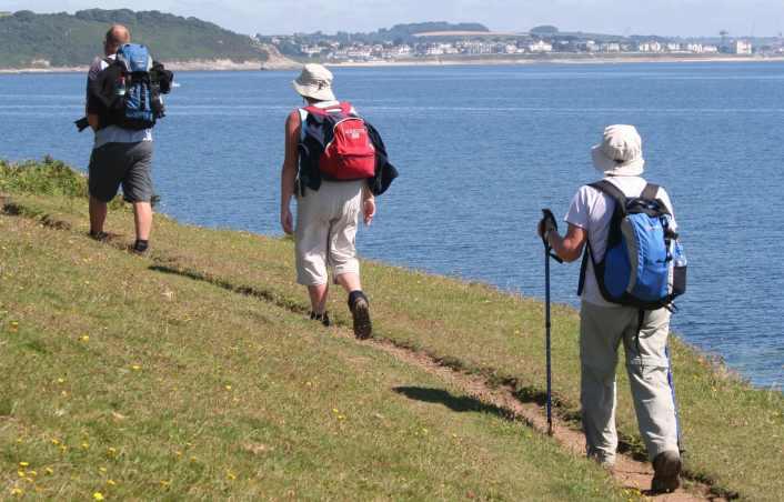
5 3 At Pennance Point turn the corner with the Coast Path and follow it past the Home Guard war memorial, to drop down to the road at Swanpool. Turn right on the road and walk down to the beach and the lake before returning to Maenporth by bus. Or simply turn around and follow the Coast Path back to Maenporth! A culvert built at Swanpool in 1825 to allow water from the freshwater lake to flow into the sea led to a unique mix of seawater and freshwater, creating one of Britain's most important brackish lagoons. The reduced water level in the lake left an area of marshland to the north west of it, fed by the six streams winding through on their way to the sea. This in turn produced a small, densely wooded wetland of mostly willow carr behind the lake: a rare and valuable environment where the willow acts as a filter, removing pollutants before they flow into the lake and providing food and shelter for many birds and small mammals. Willow trees will support as many as 450 different species of invertebrates, which in turn attracts a huge variety of birds. In all, over 100 different species of birds have been spotted at Swanpool, including mallard, moorhen, coot, little grebe and tufted duck, as well as siskin and kingfisher. Although the name is probably derived from 'swamp-pool' there are also swans nesting on the lake. Other useful information Transport information: The Western Greyhound 500 bus service travels frequently from Truro via Swanpool Beach to Maenporth Beach. For details visit or phone Toilets: Maenporth and Swanpool Beaches Car parks: Maenporth and Swanpool Beaches Refreshments: Maenporth and Swanpool Beaches, Falmouth Useful websites: ; More Walks: If you enjoyed this walk then there are other leaflets available from Reception. Walks on and around the from the Maenporth Estate Maenporth to Swanpool Walk With its sandy shoreline, clear shallow water and a treasure trove of rock pools, the beach at Maenporth is a brilliant place for a picnic. However, so is Swanpool beach, for all the same reasons, and it has the added advantage of a nature reserve behind with an abundance of wildlife. This short stroll links the two beaches: walk back the same way, or catch the bus. The species for which Swanpool is famous is invisible underwater, but it is the only one of its kind in Britain: the trembling sea mat. This exoticsounding creature consists of billions of primitive microscopic animals called bryozoa, which live in colonies attached to stones or the stems of plants. Each bryozoan is no more than two millimetres in size and is crowned by a ring of tentacles which is uses for filter feeding by catching particles in the water in the hairs on the tentacles. Produced by the South West Coast Path Team with support from: Distance: Estimated time: Difficulty: Starting point: 1½ miles/2.5 km (One way only!) ¾ hour (One way only!) Easy Maenporth Estate Text by Ruth Luckhurst The European Agricultural Fund for Rural Development: Europe Investing in rural areas This is one of the many walks that can be found at

6 Directions 1 Leave Maenporth Estate, turn left and pick up the South West Coast Path by the café and follow it up through a few trees to where it starts to pull out above the cove. There is a lane behind the cove at Maenporth called Fine and Brave Lane, named after the women of Mawnan who acted to protect the community, in the time-honoured tradition of women around the South West coast, when their men were at sea and there were threats of a French invasion. Wearing red petticoats they all marched up onto the cliffs, tricking the French into believing that there was a brigade of redcoats ready to defend the coast, so that the enemy turned tail and fled. Under the cliff, and visible at low tide from the opposite side of the cove, are the remains of the Scottish trawler the Ben Asdale, which went aground in a blizzard in There are several concrete pillboxes around the cove, sited here in the Second World War to provide cover for this part of the coast. The docks made Falmouth a prime target for enemy air raids, and at nearby Nare Head a decoy station was built to draw enemy fire away from the port. Finish Pennance Point Built by Ealing Studios, the decoy film set featured red and green stop and go lights placed in such a way as to mimic the docks and train depot from the viewpoint of a German bomber's cockpit. Remotely controlled from a hidden bunker a little further down the coast towards Porthallow, the set also simulated shafts of light streaming from an open door and a poorly shaded window. Explosions were also used to imitate trains being bombed. Start Base mapping HARVEY Helford Passage also played a key part in the Second World War, with a Secret Intelligence Service flotilla running missions between here and the Breton coast (see the Rosemullion Head Walk). In the last enemy air raid of the war, a large fuel depot behind Swanpool was blown up. The fuel, planned for use in the D-Day landings, swept through the valley in a massive torrent which threatened the houses below. The flow was diverted, thanks to the prompt actions of an American Navy officer with a bulldozer, and he was awarded the British Empire Medal. 2 At Newporth Head a path branches off to the left, inland. This cuts over the hill and drops back onto the Coast Path on the far side of Pennance Point; but carry straight on ahead along the Coast Path unless you want the diversion.


7 Estuary view Walks on and around the The Coastguard Station, just around the point, opened in 1981 and is the most southerly coastguard station in the UK. Its area extends from the Devon border on Cornwall's north coast to Dodman Point in the south, and includes the Lizard, Lands End and the Scilly Isles. With the area of sea covered reaching to 30 degrees west and 45 degrees north, this gives the station the biggest Search and Rescue region in western Europe, at around 660,000 square miles. There is also an old lime kiln on the point, once used to make lime by burning limestone and coal, which would have been brought here by ship. 4 Once you have explored the features around Pendennis Point (and the castle if you make the detour to visit it), return to the Coast Path, which now follows a footpath through woodland beside the road before coming out on the road above Falmouth Docks. 5 Carry on along the road past the docks until you come to the T-junction. 6 Turn right here, continuing across the roundabout and under the railway bridge. (There is no access to the seafront here, as the marina area is privately owned). Continue ahead on Bar Road as it curves inland and then sweeps to the right to continue in the original direction. 7 Reaching the car park on your right, turn left onto Avenue Road, passing under the railway bridge to continue ahead to the main A39 road. Crossing over, carry on in the same direction, along Gyllyngvase Road, to return to Cliff Road and retrace your steps along the Coast Path back to the car park at Swanpool. All text and photos by Ruth Luckhurst except:- Pendennis Castle by Roger Hollingsworth Other useful information Transport information: Western Greyhound Bus number 500 travels frequently from Truro via Falmouth to Helford Passage, stopping at Swanpool Beach. For details visit or phone Toilets: Swanpool and Gyllyngvase Beaches. Th e Blockhouse Car parks:pendennis Point, Gyllyngvase Seafront and Beach, Swanpool Beach. Refreshments:Swanpool and Gyllyngvase beach cafes and restaurants, seasonal. Falmouth all year round. Useful websites: ; The European Agricultural Fund for Rural Development: Europe Investing in rural areas A visit to Pendennis Point, where there have been fortifications defending Falmouth's waterways for over two millennia. Also taking in the sandy beach at Gyllyngvase and the exotic plants along the seafront. The walk is mostly flat and on easy paths and pavements. Distance: Estimated time: Difficulty: Starting point: from Maenporth Estate Pendennis Castle Walk 4 miles (6.35 km) from Swanpool Car Park 1¾ hours Easy Maenporth Estate OR Swanpool Car Park -Payment needed (Grid Reference-SW ) This is one of the many walks that can be found at


8 Directions By car leave Maenporth Estate, turn left up Maenporth Road. After about ½ mile, turn right into Swanpool Road. Follow this road all the way down to Swanpool Beach. The car park is on your left. The 500 bus stops at Maenporth and goes towards Falmouth, stopping at Swanpool Beach. If walking, please use the Maenporth to Swanpool Walk leaflet to reach Swanpool Beach. 1 From the car park at Swanpool Beach pick up the South West Coast Path towards Falmouth, behind the cafe, and follow it as it travels around Swanpool Point and drops down to Gyllyngvase Beach. Swanpool is a Nature Reserve and a Site of Special Scientific Interest, following the discovery in the 1990s that it is home to Britain's only Trembling Sea Mat, a microscopic animal which lives in colonies underwater. Its unique environment was created in 1825 when a culvert was built to allow water to flow from the freshwater lake into the sea. This led to a unique mix of freshwater and saltwater, providing a wonderful habitat for many species (see the Swanpool Nature Reserve Walk). Although there are now swans to be seen here, it is thought that the name actually derives from 'swamp-pool', after the rare wooded wetlands behind the lake. In the eighteenth century there was a lead-silver mine here, and an arsenic refinery. Gyllyngvase Road Gyllyngvase Beach is Falmouth's largest beach, a fine crescent of sand at low tide fringed by fingers of rock which provide great opportunities for rock-pooling. Along the seawall exotic plants with large lush leaves and blossom are a riot of colour in the summer and the tall palms of the dracaena in the gardens give it a tropical air. Looking across the bay, you can see Pendennis Castle looking out over the tops of the woodland on the point. 2 Follow the Coast Path along Cliff Road and then Castle Drive, which travels around the headland towards Pendennis Point. Avenue Road Swanpool 3 To visit Pendennis Castle, take the left-hand fork on the headland. Bar Road Cliff Road Castle D rive Pendennis Point Base mapping HARVEY The name Pendennis comes from the Cornish words 'pen', meaning 'head', 'end' or 'promontory', and 'dinas' (or 'dynas'), meaning 'fortress'. This suggests that there was probably a promontory fort here in the Iron Age, when many such defensive settlements were built on headlands around the coasts of Cornwall and North Devon. There has been speculation that the Romans, and later the Vikings, also used the site for defensive purposes, and there are the remains of artillery stations all around the point from later in its history (see the Falmouth Docks Walk). It is thought that the most likely place for the promontory fort would have been on the south-eastern tip of the headland, where the remains of the Tudor blockhouse of Little Dennis stand today. The blockhouse was built as a part of Pendennis Castle, constructed between 1540 and 1545, along with its partner castle across the water at St Mawes, when Henry VIII established a chain of artillery fortresses to defend the coastline from French and Spanish fleets. In 1598, during the reign of Elizabeth I, a new rampart was built around the castle, and it was strengthened again the following century, prior to the English Civil War. In 1646 the future Charles II hid out here before sailing onwards to the Scilly Islands. After this the castle was subjected to a further five months of siege before it became the penultimate Royalist garrison on the British mainland to surrender. Pendennis Point became a focus of resistance to the threat of foreign invasion once again during the nineteenth and twentieth centuries, and it saw significant action during the Second World War. Today the guardroom has been restored to the way it was during the First World War. The castle also houses the collected cartoons of George Butterworth, published daily throughout the Second World War and donated by Butterworth's widow, a near neighbour. It is said that Butterworth's cartoons of Hitler and Mussolini so infuriated the Nazi leader that he added the cartoonist's name to his hit-list. The footpath into woodland on your left here is just a pleasant (but fairly steep) detour which drops you back on the pavement a little further on along the headland.
9

10
Into the Modern Era Palmerston s Forts
 Into the Modern Era Palmerston s Forts The second half of the nineteenth century saw the emergence of a unified Germany and Italy, growing instability in Eastern Europe (the Austro-Hungarian and Turkish
Threat from the sea The Tudors: Henry VIII
 Threat from the sea The Tudors: Henry VIII From the Norman invasion of England until the fifteenth century, castles were sites from which a small number of militia could control the surrounding area. They
Sponsored by. statestreet.com
 /STATESTREETISLANDWALK #ISLANDWALKJSY Sponsored by statestreet.com Important Information If you forget everything else PLEASE remember the following.» Remember to check OUT of every checkpoint» If you
A Circular Walk from Chapel Carn Brea
 A Circular Walk from Chapel Carn Brea 4.3 Miles A Walk Visiting Five Historic Ancient Sites This circular walk offers the possibility of several alternatives, depending on the walker s available time and
Pendennis Castle HISTORY ENGLISH HERITAGE TEACHER S KIT ALSO AVAILABLE TO DOWNLOAD INFO ACTIVITIES IMAGES HIGHLIGHTS
 PAGE 1 7 HIGHLIGHTS Cornwall s greatest fortress, the most westerly of the series of artillery forts built by Henry VIII Over 400 years of defending Britain s coasts from the Tudor period through the English
Woodland Walk If you enjoyed this walk there are two others available in the same area.
 The Woodland Walk 11-12 kilometres (7-8 miles) 4-5 hours Terrain: some easy hills Can be slippery when wet 5 stiles Unsuitable for a pushchair/wheelchair Uses OS map 197 Parking: Pulborough Station and
RIVIERA LINE E X E T E R PAIGNTON
 RIVIERA LINE EXETER PAIGNTON Supported by Introduction The Riviera Line offers great scenic train journeys along the South Devon coast between Exeter and Paignton. The train is an ideal way to enjoy a
TEACHERS KIT. Pendennis Castle and St Mawes Castle
 KS1-2 KS1 2 TEACHERS KIT Pendennis Castle and St Mawes Castle KS3 KS4+ This kit has been designed to help teachers plan a visit to Pendennis Castle and St Mawes Castle which offer fascinating insight into
Reigate Hill and Gatton Park
 point your feet on a new path Reigate Hill and Gatton Park Distance: 11½ km=7 miles easy-to-moderate walking or 2 walks of 6½ km=4 miles and 5½ km=3½ miles Region: Surrey Author: Schwebefuss Refreshments:
The Northern Isles. Galapagos Island Discovery. 5 days / 4 nights exploration of the Northern Galapagos Islands on the M/V Santa Cruz
 The Northern Isles Galapagos Island Discovery 5 days / 4 nights exploration of the Northern Galapagos Islands on the M/V Santa Cruz Day 1 (Sunday): Arrive Quito You will be met on arrival at Quito airport
The Mendip Way. Route Directions and Maps Uphill to Wells
 The Mendip Way Route Directions and Maps Uphill to Wells Website: www.mendiphillsaonb.org.uk Email: mendip@mendiphillsaonb.org.uk Facebook & Twitter: @MendipHillsAONB Phone: 01761462338 1 Uphill to Loxton
The Battle of Quebec: 1759
 The Battle of Quebec: 1759 In the spring of 1759, the inhabitants of Quebec watched the river with worried eyes. They waited anxiously to see whether the ships of the French, or those of the British fleet,
Route planner Kvarner bay, Istria
 Route planner Kvarner bay, Istria base Veruda/Pula route 4 (1 week) Novigrad Opatija Porec Rovinj KRK Cres Punat NP Brijunj Veruda Medulin Pomer CRES RAB Osor UNJE LOSINJ Mali Losinj ILOVIK SILBA day:
Beautiful Walks from the Blue Ball Inn
 Walk No. 5 RIVER VALLEYS AND MOOR Countisbury, Watersmeet, Hillsford Bridge, Cheriton, Shilstone Hill, Rockford and Chiselcombe. 8.5 MILES APPROX. Walking time four and a half hours approx. OS 1;25,000
Fort Carillon/Ticonderoga
 Fort Carillon/Ticonderoga A P H O T O G R A P H I C H I S T O R Y B E H I N D T H E S T R A T E G I C K E Y T O B O T H B R I T I S H A N D A M E R I C A N V I C T O R I E S I N T H E N O R T H. S E V
The. History Walk. WWII Armaments factory
 The History Walk WWII Armaments factory 4.8-6.5 kilometres (3-4 miles) 2.5-3.5 hours Terrain: easy Can be slippery when wet No stiles Unsuitable for a pushchair/wheelchair Uses OS map 197 Parking: Pulborough
Beautiful Walks from the Blue Ball Inn
 Walk No. 2 WINSTONS WALK Countisbury, Wind Hill, Watersmeet, Ash Bridge and Winston s path. 5 Miles approx. Walking time- Two and a half hours approx. (Not including Breaks) OS 1:25,000 Sheet 64/74 Lynton
D-Day. June 6th, 1944
 D-Day June 6th, 1944 The Move on to France Because the Germans were being fought in Italy, the allies planned to move forward with their plan to open up the western front in Europe The Plan Winston Churchill
Hadleigh Castle and Chalkwell Oaze
 1 Hadleigh Castle and Chalkwell Oaze Benfleet station Hadleigh Park Hadleigh Castle Leigh-on-Sea Chalkwell station A short stroll through the lush woods of Hadleigh Park high above the Thames-side marshes,
Horden. A walk of nature...sea and history
 Horden A walk of nature......sea and history 182 283 A181 Wingate B1287 Peterlee Seaham Easington B1281 Newcastle Horden Blackhall A179 Newcastle International Airport Crimdon A1086 Location... Horden
A leisurely one mile stroll through the history of Aldershot s Manor park, considered by many as the most attractive and pleasant parts of our town.
 Figure 1 Entrance to Park from the Aldershot Green/Churchill road end A leisurely one mile stroll through the history of Aldershot s Manor park, considered by many as the most attractive and pleasant parts
Split Point Lighthouse Aires Inlet
 www.greatoceanroad.vc Great Ocean Road Three Day Tour 2 Night Stay This three day trip of approximately 730 kilometre starts from Melbourne and provides a good overview of features along the Great Ocean
Crimdon. A walk of nature...sea, sand and countryside
 Crimdon A walk of nature......sea, sand and countryside A182 B1283 A181 Wingate B1287 Peterlee Seaham Easington B1281 Newcastle Horden Blackhall A179 Newcastle International Airport Crimdon A1086 Location...
Hayle Harbour Trust, Ltd. Past, Present and Future
 Hayle Harbour Trust, Ltd. Past, Present and Future 2009, Peter Channon The History Since before De Savary, attempts have been made to gain local control of the harbour. When ING took control (through default,
Baggy Point, Croyde, North Devon
 Baggy Point, Croyde, North Devon A walk using the South West Coast Path that is likely to be suitable for people with impaired mobility or with a pushchair, wheelchair, or mobility scooter. The Coast Path
Britain s oldest surviving water-balanced cliff lift
 44 3.6 Saltburn by the Sea to Sandsend Map panels 3 and 4 Distance 17 miles (27½ km) Terrain mostly grass and field paths which can be muddy; some pavement, beach and shore Grade undulating route, with
Bewl Water & the High Weald
 1 Bewl Water & the High Weald Stonegate station - Stonegate - Wallcrouch - Newbarn - Cousley Wood - Wood's Green - Wadhurst station Length: 9 ½ miles (15.3km) Underfoot: Large portions of this path are
Eastbourne. Alfriston 3¾ 6 3¾ 6. Birling Gap. Exceat
 3.8a Alfriston to Eastbourne (footpath) Map panel 6 (page 64) Distance 10½ miles (17 km) Terrain valley walk initially, first along riverbank path then hillside paths above, including stretch through forest;
Canada s Contributions Abroad WWII
 Canada s Contributions Abroad WWII Battle of the Atlantic (1939-1945) Struggle between the Allied and German forces for control of the Atlantic Ocean. The Allies needed to keep the vital flow of men and
DAY 3: Huntleys Point Wharf to Balmain East Wharf
 DAY 3: Huntleys Point Wharf to Balmain East Wharf Total Distance: 14.5km Time: Approximately 5 hours Walk Notes in Five Sections Section Name Length Time 3:1 Huntleys Point Wharf to Iron Cove Bridge 4km
PASSIVE VOICE. Sightseeings of London
 PASSIVE VOICE. Sightseeings of London The project has been done by the students of the 9 th form: Akhmetvaleeva Julia Murzakhanov Ilgiz Tatar gymnasium 14 How often do we use Passive Voice? We use it everywhere,especially
Great Ocean Road Two Day Tour
 www.greatoceanroad.vc Great Ocean Road Two Day Tour This two day trip of approximately 530 kilometre starts from Melbourne and provides a good overview of features along the Great Ocean Road between Anglesea
TRESELLICK GARDENS, FALMOUTH
 TRESELLICK GARDENS, AN EXCITING, STYLISH DEVELOPMENT SITUATED ABOVE GREENBANK, WITHIN A FIVE MINUTE WALK INTO CENTRAL WITH WATER VIEWS TRESELLICK GARDENS, LOCATION AN EXCITING, STYLISH DEVELOPMENT OF EIGHT
Centurions Spring walk 22 nd March 2014
 Centurions Spring walk 22 nd March 2014 Where Romans once stood; a walk around Canvey Island When the Romans needed salt they came to Canvey Island. As Centurions we will walk upon the Islands soil and
Hindhead, Keffolds Copse and Gibbet Hill
 point your feet on a new path, Keffolds Copse and Gibbet Hill Distance: 6 km=4 miles Region: Surrey Author: Schwebefuss Refreshments: Punch Bowl Café moderate walking Date written: 14-apr-2015 Last update:
Bass Point The Lizard
 Bass Point The Lizard Lloyd s Signal Station Bass Point, The Lizard, TR12 7AP Iconic art deco former signal house set on England s most southerly point Housel Bay 600 metres Kynance Cove 3 Kennack Sands
DAY 1: Circular Quay to Greenwich Wharf
 DAY 1: Circular Quay to Greenwich Wharf Total Distance: 14km Time: Approximately 5 hours Walk Notes in Six Sections Section Name Length Time 1:1 Circular Quay to Milsons Point Station 2.5km 50mins 1:2
FOR SALE INDIAN OCEAN BEACHFRONT- HEADLAND PLOT
 June 2017 FOR SALE INDIAN OCEAN BEACHFRONT- HEADLAND PLOT Rasini, Kimbiji, Kizito Huonjwa, Temeke, Dar es Salaam, Tanzania A UNIQUE opportunity to acquire 9 hectares/22 acres of natural cliff and beachfront
DEVELOPMENT OPPORTUNITY. Former Rosslyn Hotel. Proposed student scheme. Kimberley Park Road
 DEVELOPMENT OPPORTUNITY Former Rosslyn Hotel Proposed student scheme 110, Kimberley Park Road Cornwall, TR11 2JJ LOCATION sits at the head of the river Fal and has excellent communication links being the
Start. Directions. Finish at Perran Sands Holiday Park
 Directions 1. Take the 587 bus towards Newquay from the bus stop at Perran Sands entrance and get off at Crantock. Head down Halwyn Hill to the square and turn left down Green Lane to take the footpath
Self-Guided Walk Malham, Gordale and Malham Tarn
 Self-Guided Walk Malham, Gordale and Malham Tarn Combine all the major geological attractions of Malham in this walk and hopefully leave enough time to enjoy the cafes, pubs and shops of the village. Malham
Slad over to Pitchcombe and back
 The walk climbs up from Slad over Wickridge Hill, descends to near Pitchcombe, then climbs back over Wickridge hill and round the back of Slad. Page 1 Start Point: SO 8718 0732 The Woolpack, Slad Length:
Pendennis Castle ENGLISH HERITAGE TEACHER S KIT. A resource for Travel and Tourism students
 make the most of their visit to. BACKGROUND INFORMATION In this section you will find a variety of information on. Topics include: A short history Development as a tourist attraction The work of English
w w w. d r a k e s - i s l a n d. c o m
 w w w. d r a k e s - i s l a n d. c o m 1 A Piece of History Named after Plymouth s most famous patron and situated in the heart of Plymouth Sound, Drake s Island has a rich history having been a religious
ters, a chapel, a bakery, a gun powder magazine and storerooms for supplies. The fort
 Old Fort Niagara s Flintlocks and Council Fires is an educational program that covers over 80 years of amazing history! This booklet will tell you about historic events that took place right in your backyard,
LONDON. the capital of ENGLAND
 LONDON the capital of ENGLAND Tower of London The Tower of London, seen from the river, with a view of the water gate called Traitors Gate. In 1078, William the Conqueror built the first part of the Tower,
3.1 Bowness-on-Solway to Carlisle
 3.1 Bowness-on-Solway to Carlisle Map panel 1 Distance 15 miles (24 km) Terrain minor roads, tracks, field paths and riverside footpath, muddy in places Grade easy, with gentle gradients on undulating
RURAL LAND RESOURCES Case study area 1- the erosional features of the Dorset Coast.
 Case study area 1- the erosional features of the Dorset Coast. Scene setting;- This area lies on the far south coast of England, between the settlements of Lyme Regis and Bournemouth, in the county of
Jerusalem Bay Track (Cowan to Brooklyn)
") Jerusalem Bay Track (Cowan to Brooklyn) 5 hrs 30 mins 13.4 km One way Hard track 4 654m This Cowan to Brooklyn Station walk is a popular section of the Great North Walk, with scenery ranging from foreshore
Jerusalem Bay Track (Cowan to Brooklyn) 5 hrs 30 mins 13.4 km One way Hard track 4 654m This Cowan to Brooklyn Station walk is a popular section of the Great North Walk, with scenery ranging from foreshore
Fetcham Downs and Bocketts Farm A magical teashop walk
 point your feet on a new path Fetcham Downs and Bocketts Farm A magical teashop walk Distance: 3 km=2 miles or 4 km=2½ miles Region: Surrey Author: Fusszweig Refreshments: Bocketts Farm easy walking Date
The Magic of Cornwall
 The Magic of Cornwall This tailor-made programme offers an in-depth tour of England s south-westerly county Dream Escape provides the creativity and insider access to show you the secret villages and hidden
Jersey International Motoring Festival 2016
 Jersey International Motoring Festival 2016 Enjoy a Wonderful 5 or 7 Day Tour to the Channel Islands for the 2016 Jersey International Motoring Festival! Jersey Sparkling Seas, golden sands, rugged cliffs,
The Year of Go Do Year of Go Do. Aim to re-awaken the adventurer in all visitors
 The Year of Go Do 2018 Year of Go Do Aim to re-awaken the adventurer in all visitors Focus on key strategic themes islandhopping, walking, heritage, food, wellness Go somewhere close to home but feel a
Access Statement for RSPB Lochwinnoch
 Introduction This access statement does not contain personal opinions as to our suitability for those with access needs, but aims to accurately describe the facilities and services that we offer all our
The Windrush. Page 1 of 2. visit twinkl.com
 HMT Empire Windrush began sailing in 1930. It was originally used as a cruise ship and passenger liner. However, during the Second World War, she was used as a troopship. At first, she was used to transport
DEFENCE AREA 73 FRESHWATER BAY
 DEFENCE AREA 73 FRESHWATER BAY 1. Area details: The defence area is 3½ miles from The Needles and 10 miles W of Newport. County: Isle of Wight. Parish: Freshwater. NGR: centre of area, SZ 346860. 1.1 Area
Pontfadog. Walk A. Walk A
 Walk A A Bird s eye view of the village 2km. (1 1 /2 miles); height gain 45m. (150ft) about 45 minutes. Six minutes walk along the main road towards Glyn Ceiriog reach a signpost to Llwynmawr. Take the
Key Information. Self-Guided Walk Corfe Castle to Swanage
 Self-Guided Walk Corfe Castle to Swanage A classic walk from the pretty village of Corfe Castle. Enjoy extensive views whilst walking along the wide ridge to the popular seaside town of Swanage, returning
Cinque Terre (Short Break) The best walks between coloured villages and terraced vineyards TRIP NOTES 2019 Genius Loci Travel. All rights reserved.
 The best walks between coloured villages and terraced vineyards TRIP NOTES 2019 Genius Loci Travel. All rights reserved.") Cinque Terre (Short Break) The best walks between coloured villages and terraced vineyards TRIP NOTES 2019 Genius Loci Travel. All rights reserved. INTRODUCTION The Cinque Terre gets its name from the
Cinque Terre (Short Break) The best walks between coloured villages and terraced vineyards TRIP NOTES 2019 Genius Loci Travel. All rights reserved. INTRODUCTION The Cinque Terre gets its name from the
Limestone terraces (in the distance) and woodland on hills in the Upper Wharfedale valley
 and woodland on hills in the Upper Wharfedale valley") GRASSINGTON North Yorkshire from www.discoverbutterflies.com the website for the book Discover Butterflies in Britain D E Newland 2009 Limestone terraces (in the distance) and woodland on hills in the
GRASSINGTON North Yorkshire from www.discoverbutterflies.com the website for the book Discover Butterflies in Britain D E Newland 2009 Limestone terraces (in the distance) and woodland on hills in the
CASTLE COURT PORTLAND
 CASTLE COURT PORTLAND DRAMATIC LOCATION NAVAL HISTORY Not really an island, is really a huge block of limestone (approx. 5 miles long) reached over an impressive narrow causeway with spectacular Chesil
Burgos lies on the main highway from France to
 Burgos Then and Now: the Sierge of 1812 By Gareth Glover The Napoleon Series BURGOS IN 1812 Burgos lies on the main highway from France to Valladolid, at a point where the road south to Madrid forks off.
Berowra Waters to Cowan Station
 Berowra Waters to Cowan Station 3 hrs 30 mins 7.2 km One way Hard track 597m This is a hilly walk out of the beautiful Berowra Waters valley to Cowan Station. There are many wide views across Berowra Creek
The Western Isles. Galapagos Island Discovery. An in-depth 7 day/6 night exploration of the western Galapagos Islands onboard the M/Y La Pinta
 The Western Isles Galapagos Island Discovery An in-depth 7 day/6 night exploration of the western Galapagos Islands onboard the M/Y La Pinta Day 1 (Thursday): Arrive Quito On arrival at Quito airport,
The Hundred Parishes
 The Hundred Parishes Walks from railway stations number 3 3 miles (5kms) circular walk from Stansted Mountfitchet Start & finish: Stansted Mountfitchet station. Ordnance Survey Explorer Map 195. Grid Reference:
Much of the information which follows is included by kind permission of the Tynedale Council (now defunct) and is based on its brochure.
 and is based on its brochure.") The Tyne Green Trail This easy going circular walk is on level ground throughout. It follows the course of the River Tyne between Hexham Bridge and the turning point just past Watersmeet. The return is
The Tyne Green Trail This easy going circular walk is on level ground throughout. It follows the course of the River Tyne between Hexham Bridge and the turning point just past Watersmeet. The return is
Cormorant and Guillemot WEST PENTIRE CRANTOCK CORNWALL
 and WEST PENTIRE CRANTOCK CORNWALL Nearby Crantock Bay (view not from property) and West Pentire Crantock Cornwall TR8 5SE Fabulous coastal property with a two bedroom annexe overlooking Crantock Bay
The Eden Project The Eden Project in Cornwall consists of two biomes that include plants from many different climates and environments.
 The Eden Project The Eden Project in Cornwall consists of two biomes that include plants from many different climates and environments. The Angel of the North This steel sculpture is 20 metres tall and
Dover Castle Planning your Group Visit
 Dover Castle Planning your Group Visit Please do not hesitate to contact us on: Tel: +44 (0) 1304 211 067 Fax: +44 (0) 1304 214 739 www.english-heritage.org.uk/dovercastle Timed itineraries Depending on
BISHOPSTONE CIRCULAR WALK
 BISHOPSTONE CIRCULAR WALK 4½ miles (7¼ km) - allow 2 hours (see maps on final pages) Introduction This walk is within the North Wessex Downs Area of Outstanding Natural Beauty and starts from the small,
Freefolk and Whitchurch
 Trail Activity Type Terrain Author Distance Ascent Location : HAMPTR0026 : Walk : Tea Shop : Towpaths and Cycle Tracks : Jean Patefield : 5.6 miles / 9 kms : 377 feet / 115 metres : SU487488 / RG28 7NN
ID: 283 Distance: 6.2 miles Height gain: 500 Metres Map: Explore OL 19 Contributor David and Chris Stewart
 Walkingworld Wild Boar Fell ID: 283 Distance: 6.2 miles Height gain: 500 Metres Map: Explore OL 19 Contributor David and Chris Stewart Features Birds, Great Views, Hills or Fells Description: Wild Boar
Girrakool to Wondabyne station via Pindar caves
 Girrakool to Wondabyne station via Pindar caves 7 hrs 30 mins 18.1 km One way Experienced only 5 741m This walk starts from the Girrakool picnic area and winds south, following Piles creek into the Brisbane
FUNActive Tours GmbH. Self-guided tour 8 days / 7 nights. Description. Characteristics of the route
 hikingholiday Cinque Terre and the Portofino Peninsula Self-guided tour 8 days / 7 nights Description The Cinque Terre gets its name from the five picturesque villages of Monterosso, Vernazza, Corniglia,
Website:
 English Tourism Council Appointed TOURING & CAMPING PARK Website: www.carlyonbay.net E-mail: holidays@carlyonbay.net Welcome to Carlyon Bay Welcome to the award-winning Carlyon Bay Caravan & Camping Park,
THE CARIBBEAN SIDE OF PORTOBELO AND THE CHAGRES RIVER
 THE CARIBBEAN SIDE OF PORTOBELO AND THE CHAGRES RIVER PORTOBELO, CHAGRES RIVER, SAN LORENZO FORT, MONKEY S TRAIL 4D/3N Suggested age: 6 years and up The Experience Set sail from the Portobelo Bay, revel
Nature Track. 900m. 789m. 2 hrs 3.1 km Circuit. Hard track 238m. Blue Mountains National Park
 Nature Track 2 hrs 3.1 km Circuit Hard track 238m Largely following the ridges around the top edge of Wentworth Falls, this track is incredibly beautiful. After taking in the great views at Edinburgh Castle
Approximate distance: 4.5 miles For this walk we ve included OS grid references should you wish to use them. Start. End
 Approximate distance: 4.5 miles For this walk we ve included OS grid references should you wish to use them. 2 1 Start End 4 3 N W E S Reproduced by permission of Ordnance Survey on behalf of HMSO. Crown
Palinuro & the South Coast of the Cilento National Park
 Palinuro & the South Coast of the Cilento National Park The mythical headland of Palinuro and the pristine coast of Camerota TRIP NOTES 2018 Genius Loci Travel, 2017. All rights reserved. INTRODUCTION
Walk 1. Cotswold Water Park. Gateway Centre to Cerney Wick, railway track to Lake 6, Gateway Centre.
 Cotswold Water ark Walk way A Swindon/ Cirencester Thomas and Severn Canal way to Cerney Wick, railway track to Lake, way. Spine Road East Hotel Time: hours (short walk km) Distance: km A level walk along
relax in parklands...
 relax in parklands... Welcome St. Margaret s park offers a choice of quality holiday accommodation set in the heart of Cornwall. Twenty-nine self catering holiday lodges and superbly restored 18th Century
West Wirral (Dee Estuary)
") View of Hilbre Island from West Kirby with walkers at low tide. West Wirral (Dee Estuary) West Kirby is the start of the 12 mile long Wirral Way, the backbone of Wirral Country Park, the old Hooton to
View of Hilbre Island from West Kirby with walkers at low tide. West Wirral (Dee Estuary) West Kirby is the start of the 12 mile long Wirral Way, the backbone of Wirral Country Park, the old Hooton to
Darwin s gigantic blunder
 Trail Darwin s gigantic blunder Explore how ice shaped the landscape and why Charles Darwin made a nice mess of Glen Roy Time: 1hr 10 mins Distance: 2 miles Landscape: rural At Glen Roy a curious feature
Illawarra Escarpment State Conservation Area Walking Tracks
 Illawarra Escarpment State Conservation Area Walking Tracks NPWS Illawarra Area Office Ground Floor, Government Office Block 84 Crown Street Wollongong NSW 2500 02 4223 3000 (Mon-Fri) Royal National Park
Scenic Railway to Ruined Castle
 Scenic Railway to Ruined Castle 7 hrs 30 mins 12.4 km Return Hard track 4 963m This is a very popular, full day walk, in the Katoomba Area, offering great views of the valley. The walk follows the edge
Guided Notes - Persian & Peloponnesian Wars
 Guided Notes - Persian & Peloponnesian Wars The Persian Wars - 510-478 B.C.E Major Battles: Marathon, Thermopylae, Salamis, & Plataea The Persians: Led by Began creating one of the world s largest empires
England & Scotland #1
 England & Scotland #1 Sports Tour London, Edinburgh, Glasgow 10 Day / 8 Night Program www.victorysportstours.com SUGGESTED PROGRAM PLEASE NOTE: Actual sequence and timing of activities will revolve around
THE COMMERCIAL ROUTE OF PIRATES, CONQUERORS & PEOPLE CASCO ANTIGUO, PANAMA LA VIEJA, AGUA CLARA LOCK GATES, SAN LORENZO FORT, PORTOBELO 3D/2N
 THE COMMERCIAL ROUTE OF PIRATES, CONQUERORS & PEOPLE CASCO ANTIGUO, PANAMA LA VIEJA, AGUA CLARA LOCK GATES, SAN LORENZO FORT, PORTOBELO 3D/2N Suggested age: 6 years and up The Experience The commercial
NARRABEEN LAGOON SUMMIT am Wednesday, 13 April 2005 Warringah Council Chambers, 725 Pittwater Road, Dee Why.
 NARRABEEN LAGOON SUMMIT 9.15 9.30am Wednesday, 13 April 2005 Warringah Council Chambers, 725 Pittwater Road, Dee Why. NSW Minister for the Environment, the Hon. Bob Debus I am very pleased to be here to
The Swansea Canal near Glanrhyd north of Pontardawe
 INSPIRING LANDSCAPES FASCINATING HISTORY & LEGEND GREAT WALKS IN THE SWANSEA VALLEY Pontardawe to Ystalyfera along the Swansea Canal and Cycle Path and the Legend of Ynysygeinon Rock! Historic & Geographic
Access Statement for RSPB South Stack Cliffs
 Introduction This access statement does not contain personal opinions as to our suitability for those with access needs, but aims to accurately describe the facilities and services that we offer all our
Channel Islands Occupation Society
 INTRODUCTION The subject of the Conservation Statement is Kempt Tower, built in 1834 in St Ouen s Bay, Jersey. The primary purpose of the statement is to draw together existing information, to set down
The Don Gorge A Landscape reclaimed by nature
 The Don Gorge A Landscape reclaimed by nature Walk summary: A walk taking in historical and natural features of the Don Gorge, including Sprotbrough weir and fish pass, the lost village of Levitt Hagg,
Drive and Stop Routes
 Drive and Stop Routes Limantour Road 1 - easy and likely productive. From Bear Valley Visitor Center drive back out and turn left onto Bear Valley Rd. Turn left at Limantour Road (the first road). Drive
This page helps you find out more about Bute Park. (Including Coopers Field and Blackweir)
") This page helps you find out more about Bute Park. (Including Coopers Field and Blackweir) Bute Park Useful information is set out under the following headings: Summary Features of interest Facilities
This page helps you find out more about Bute Park. (Including Coopers Field and Blackweir) Bute Park Useful information is set out under the following headings: Summary Features of interest Facilities
State of Nature 2016
 State Nature 2016 State Nature 2016 Results look up tables This document presents tables the results referred to in the report in an easy to access format. All data presented here feature in the report
Map: Landranger #27 Forres and Nairn and 36 Grantown and Aviemore
 THE DAVA WAY This is a newly created long distance route that runs from Forres to Grantown, mostly following the old railway line. You will need to detour around a couple of sections that are not really
HARBOR INFRASTRUCTURE INVENTORIES Buffalo Harbor, New York
 HARBOR INFRASTRUCTURE INVENTORIES Buffalo Harbor, New York Harbor Location: Buffalo Harbor is located on the Eastern shore of Lake Erie in the City of Buffalo, NY. Authority: River & Harbor Acts of 1826,
Leura Cascades to Gordon Falls Reserve
 Leura Cascades to Gordon Falls Reserve 1 hr 15 mins 1.8 km One way Moderate track 200m From Leura Park to Gordon Falls Park, this diverse walk offers fantastic views of the Jamison Valley, as well as two
Larne man survived sinking of destroyer which was almost called HMS Larne
 remembrance ni Larne man survived sinking of destroyer which was almost called HMS Larne Larne man Tommy Shields, a survivor of HMS Gurka off Norway. And on duty in the Red Sea in 1939. Tommy died 18/07/2005