U3A Markfield and Hill Hole Quarry
|
|
|
- Alicia Washington
- 5 years ago
- Views:
Transcription

 Waypoints Field Head and Markfield (52.68654; -1.")
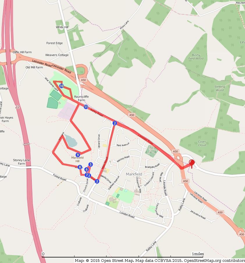
1 U3A Markfield and Hill Hole Quarry Stuart Galloway Route Summary Circular walk around Markfield including Hill hole quarry and the Altar Stones Route Overview Category: Walking Length: km / 3.48 mi Last Modified: 5th April 2016 Difficulty: Medium Rating: Unrated Surface: Average Date Published: 5th April 2016 Description The village trail starts at The Field Head hotel on Markfield Lane, Markfield LE67 9PS. There is plenty of free parking alongside the pub. The route is about 4-5 miles. No stiles. Some steep steps.(bring binoculars if it is a clear day fabulous views at Hill Hole Quarry & Altar Stones) Waypoints Field Head and Markfield ( ; ) The Field Head hotel was originally a farmhouse dating from 1672, for many years a popular hotel, pub and restaurant. Markfield village, known as Mercenfeld in Anglo-Saxon times, is situated on the A50/A511 near J22 of the M1 Motorway, on the edge of the ancient Charnwood Forest. One of the highest villages in Leicestershire, and some would also say it is one of the coldest! It is home to very old and very hard volcanic rock called Markfieldite, has stone cottages, a disused quarry open to public access and lots of interesting history. 1 / 7
2 Carefully cross the main A511 at the pedestrian lights dual carriageway turn right and cross Launde Road onto Leicester Rd. Follow Leicester Rd until you reach Main St, turn left and keep on the left hand side pavement. Houses on Main Street ( ; ) In the middle of the road (the triangle) was the Old police house(including cells) where the local bobby lived until the 1960?s. To the right there is a house called Clarke?s Place, where in the mid-20th century a horse breaker Sid Clarke lived. It is reported that he went everywhere by horse but refused to dismount so shouted at the shopkeepers to bring his orders out to him. No.188 was the home of the village doctor, a large wooden hut in the garden was the surgery. Further along was the home of Wardle?s butchersand the building to the right was the slaughterhouse. At no. 173 there is a dilapidated green shed? this was originally the Barber?s shop. The shed was ordered from London and delivered by train to Bardon Hill station. On the right you will see an Indian restaurant formerly the Red Lion. Originally the Red Lion was next door in the white building and was built in This was also formerly the post office. On the left you will see The Institute (the?stute?) originally a picture house around 1920 showing silent films. The projection room and ticket kiosk are still there. After the First World War the picture house was converted into a Memorial Hall, and a little further along you will see the Congregational church built in The Old Rectory was built in 1770 and was used as a school for many years; it didn?t become the rectory until (The rectory was replaced by a new one built at the rear in 1960). Continuing along Main St until you reach the Green You will pass the Congregational Church Hall built in 1852 by Henry Chapman (his family were prolific builders and probably built most of the old village), Brown?s hardware shop; originally the Earl Grey Arms and a little further along you will see the façade of the George Hotel; a new Co-op store has been built at the rear of the premises. There has been a Co-operative store in Markfield for over a century. It is thought another of Markfield?s lost pubs? The Boot Inn was also in this vicinity. The new houses on Warner Close off Main St were originally the home ofwarner?s Bus garage. Opposite the Green is the former Wardle?s Baker?s Shop, which closed in the 1990?s (also formerly a grocer?s and a newsagent?s). To the left of Wardle?s is the Trinity Methodist Church, built as the Wesleyan Methodist Chapel and nearby at no. 54 the Mill House(probably driven by water but not a windmill). 2 / 7
3 The Green ( ; ) Opposite on the Green (formerly known as the Sawpit) you will see the green painted Village Pump. This is a replica. All that remains of the original is the old wooden post. There were a number of wells in the village (hard to dig with the underlying granite). Mains water was not installed until the 1920?s. Cross the Green noting the National School and the School House on the right. The National School ( ; ) The National school was built in 1861 and the School house in (There is an old school desk in the garden of the School house). To the right of the School house was another of Markfield?s old pubs? The Plough Inn.(The village boasted 11 pubs at one time? quarrying was thirsty work). Continue uphill on the right hand side of the Green until you see a newly renovated building. Temperance Hall ( ; ) After the Methodists moved to a new building it housed framework knitting machines and then became a motor workshop. Continue past the building through the gate onto the track turn left up the steps and then walk back down to Hillside keep to the left and enter the churchyard through the gate on your right. (Optional? you could just turn round and walk back down to the church gates). St Michael & All Angels Church ( ; ) There has been a church on this site since at least 1072; the current church (St Michael & All Angels) is mostly 13th? 14th century. In 1825 the lean-to North aisle was removed and the chancel arch cut away. However by 1865 the church was said to be in a ruinous state and it was rebuilt with the chancel, vestries and north aisle added. The organ dates from 1906 and the names of those who served in the First World War are inscribed on its panelling. The bells date from 1617, 1749, (three) and a sixth bell added after the Second World War in thanksgiving for victory. Rectors were appointed by the Hastings family for many years, the last occasion being the Rev AS Butler in He presided over the 1865 restoration, the building of the Church School on The Green and the opening of the Mission Church in Shaw Lane. Zigzag carved patterns to the right of the porch are typically Norman. Take a look at 3 / 7
4 the interesting tombstone of Friswid Bodin, mother of 12 who died at the age of 64. Leave the church via the main gate Blue Plaque ( ; ) On the right you will see a blue plaque to John Wesley; a frequent visitor and preacher. Such were the crowds who attended his sermons he preached outside. Continue past the houses until you reach Queen Street. On the house on the left corner there is a date stone 1700? this property was once a sweet shop and grocers run by the Widdowsons. Walk into Queen St for a few yards then take the footpath to the right up some quite steep steps In Queen St you will see Quarry House (formerly the Quarryman?s Arms) and Three Gables (one of the four bakeries in the village). Quarryman's Cottages ( ; ) At the top of the steps you will be on Hillside where there is a row of quarryman?s cottages. These cottages have very long, steep, narrow gardens where the vegetables would be grown for the family. At the end of the garden would be the privy, the contents of which were emptied regularly by the nightsoil men. Turn to the left and follow the footpath (on your left) until you come to Hill Lane (take care there is no footpath). Turn right and follow the road until you come to the first entrance to Hill Hole quarry, now a nature reserve. Observe the information on the notice board before continuing on the path to the left overlooking the quarry. Keep walking until ahead of you you will see some steep steps cut in the hillside. Climb the steps and at the top keep to the path on the right and climb until you reach the view point. (Binoculars essential to appreciate the views from the toposcope). Hill Hole Quarry ( ; ) The view point at Hill Hole quarry is about 700ft above sea level. It was used as an observation post in the Second World War? the hut was burned down as soon as the war was over. Hill Hole quarry opened in 1852, the rock Markfieldite is a very hard granite and visible in many local buildings. It was also used for making setts for paving roads. The quarry was worked until about There was a windmill on the hill 4 / 7
5 from at least 1743, but the sails had gone by the 1870?s. Fir trees on the hill top were cut down in World War 1 for use as pit props in the nearby Desford Colliery. Children as young as nine were employed in the quarry. At least 6 deaths occurred in the late 19th century. The water in the quarry is about 5m deep and holds fish as well as North Atlantic Crayfish (a rare species). Retrace your steps downhill and take the path to the left until you reach the small car park. Turn right onto Hill Lane and follow the road to the crossroads. Turn left onto Altar Stones Lane. Continue along the lane and just prior to Old Mill Farm turn right through the gate onto the area known as Altar Stones and Blacksmiths field (now managed by the Leics & Rutland Wildlife Trust). Walk through the fields enjoying the views. Altar Stones ( ; ) Altar Stones is a reference to a vanished landmark referred to in a 14th century document. It may have been a Roman altar stone, a boundary stone or a milestone; it was in a nearby field and described as being covered in strange writing. It was removed in 1769 but no one knows what became of it. There was a millers barn on the right and in the fields behind stood Markfield?s other windmill (four stone piers remain). This windmill blew down in Blacksmith?s field is now a nature reserve and home to a radio mast using a system called Raynet. Under the mast there is a deep bunker. Local councils were required to make contingency plans in case of nuclear war for alternative communications. The emergency control centre was the cellar of the nearby Red Lion. Leave the Nature reserve and turn left back onto Altar Stones Lane. Cross the road onto Ashby Road. Ashby Turnpike ( ; ) The house on the corner called Raunscliffe was once a blacksmith?s shop. The road here was part of the Ashby Turnpike and a tollgate stood here. The first weekly stagecoach service to London started in It took a full day and cost about 1.25 for an inside seat. Opposite Raunscliffe there is a row of council houses thought to be the first built in Leicestershire in No.35 Ashby Rd was the home of haulage contractor Laurie Brown. He was a haulage contractor who delivered coal in the 1920?s using a Chevrolet truck which could be converted into a bus with wooden slatted seats and a portable top. He called it the?nancy? after his sister. Eventually he built up a big fleet of buses known as Browns Blue and took over Warners in Browns Blue was sold to Midland Red in / 7
6 Continue along Ashby Rd (views over the Chitterman Hills on your left) past the Queens Head P.H. and retrace your steps along Leicester Rd and back to the Field Head Hotel 6 / 7
7 7 / 7
U3A WTT Bagworth. Route Summary. Route Overview. Description. Waypoints. Sculpture. Stuart Galloway. A circular walk around Bagworth.
 U3A WTT Bagworth Stuart Galloway Route Summary A circular walk around Bagworth. Route Overview Category: Walking Length: 6.450 km / 4.03 mi Parking: Bagworth Heath Date Published: 27th April 2016 Difficulty:
The Hundred Parishes
 The Hundred Parishes Walks from railway stations number 3 3 miles (5kms) circular walk from Stansted Mountfitchet Start & finish: Stansted Mountfitchet station. Ordnance Survey Explorer Map 195. Grid Reference:
U3A WALK Harby Hose. Route Summary. Route Overview. Description. Waypoints. Harby. Stuart Galloway
 U3A WALK Harby Hose Stuart Galloway Route Summary A circular walk taking in Harby, Hose and the Grantham Canal. Route Overview Category: Walking Length: 7.310 km / 4.57 mi Parking: Village Hall School
U3A WTT Mountsorrel Circular
 U3A WTT Mountsorrel Circular Stuart Galloway Route Summary A circular walk around Mountsorrel taking in a visitors centre at Mountsorrel Station, part of the Great Central Railway heritage railway. Also
Pontfadog. Walk A. Walk A
 Walk A A Bird s eye view of the village 2km. (1 1 /2 miles); height gain 45m. (150ft) about 45 minutes. Six minutes walk along the main road towards Glyn Ceiriog reach a signpost to Llwynmawr. Take the
Morgan s Vale and Woodfalls History Trail. (You could start at any point and follow the trail round)
") Morgan s Vale and Woodfalls History Trail (You could start at any point and follow the trail round) 1) MORGAN S VALE & WOODFALLS PRIMARY SCHOOL Built in 1869, it served as a church on Sundays until the
Morgan s Vale and Woodfalls History Trail (You could start at any point and follow the trail round) 1) MORGAN S VALE & WOODFALLS PRIMARY SCHOOL Built in 1869, it served as a church on Sundays until the
Leaden Boot Challenge ROUTE INSTRUCTIONS
 Leaden Boot Challenge ROUTE INSTRUCTIONS Section 1 Alstonefield to Ilam From the village hall car park turn R then L and pass through the village keeping to the R to enter Church Street. Pass the Church
Walk 1. Cotswold Water Park. Gateway Centre to Cerney Wick, railway track to Lake 6, Gateway Centre.
 Cotswold Water ark Walk way A Swindon/ Cirencester Thomas and Severn Canal way to Cerney Wick, railway track to Lake, way. Spine Road East Hotel Time: hours (short walk km) Distance: km A level walk along
Britain s oldest surviving water-balanced cliff lift
 44 3.6 Saltburn by the Sea to Sandsend Map panels 3 and 4 Distance 17 miles (27½ km) Terrain mostly grass and field paths which can be muddy; some pavement, beach and shore Grade undulating route, with
Aston Rowant Discovery Trail
 The walk was developed by Aston Rowant Parish Council. The Trail is stile-free and fully way-marked. The circular route is 5.3m but with the extension to a pub and hotel 6.2m. Key Main Aston Rowant Discovery
Leaden Boot Challenge 2016 ROUTE INSTRUCTIONS
 Leaden Boot Challenge 2016 ROUTE INSTRUCTIONS Section 1 Alstonefield to Ilam (CP2) From the village hall car park turn R then L and pass through the village keeping to the R to enter Church Street. Pass
BISHOPSTONE CIRCULAR WALK
 BISHOPSTONE CIRCULAR WALK 4½ miles (7¼ km) - allow 2 hours (see maps on final pages) Introduction This walk is within the North Wessex Downs Area of Outstanding Natural Beauty and starts from the small,
Woodland Walk If you enjoyed this walk there are two others available in the same area.
 The Woodland Walk 11-12 kilometres (7-8 miles) 4-5 hours Terrain: some easy hills Can be slippery when wet 5 stiles Unsuitable for a pushchair/wheelchair Uses OS map 197 Parking: Pulborough Station and
Beamers Trail. Walk No.1. 6 miles. (easy with some moderate ascents and descents)
") Beamers Trail Walk No.1 6 miles (easy with some moderate ascents and descents) 1 BEAMERS TRAIL 6 miles (easy with som WALK The Warpers Trail forms part of the long distance Witton Weavers Way. This is
Beamers Trail Walk No.1 6 miles (easy with some moderate ascents and descents) 1 BEAMERS TRAIL 6 miles (easy with som WALK The Warpers Trail forms part of the long distance Witton Weavers Way. This is
Hay Wood, Rowington and Baddesley Clinton - Warwickshire
 Hay Wood, Rowington and Baddesley Clinton - Warwickshire Starts at Lay-by alongside Hay Wood 2 hours 30 minutes 5.5miles 8.8km Leisurely ID: 0.683 Developed by: John Clift Checked by: Andy Page www.ramblersroutes.org
Slad over to Pitchcombe and back
 The walk climbs up from Slad over Wickridge Hill, descends to near Pitchcombe, then climbs back over Wickridge hill and round the back of Slad. Page 1 Start Point: SO 8718 0732 The Woolpack, Slad Length:
Walk 1: Highfield, Lob Wood and The River Wharfe
 Walk 1: Highfield, Lob Wood and The River Wharfe Start: The Hen Pen Garden, Main Street, Addingham LS29 0NS, SE 077 498. Alternative Start: Near Bolton Bridge SE 071 525 (see page 6). Full walk: 4.5 miles
Beautiful Walks from the Blue Ball Inn
 Walk No. 5 RIVER VALLEYS AND MOOR Countisbury, Watersmeet, Hillsford Bridge, Cheriton, Shilstone Hill, Rockford and Chiselcombe. 8.5 MILES APPROX. Walking time four and a half hours approx. OS 1;25,000
Self-Guided Walk Malham, Gordale and Malham Tarn
 Self-Guided Walk Malham, Gordale and Malham Tarn Combine all the major geological attractions of Malham in this walk and hopefully leave enough time to enjoy the cafes, pubs and shops of the village. Malham
Appendix 7.1 Archaeology Gazetteer
 Cuadrilla Elswick Limited Temporary shale gas exploration at Roseacre Wood, Lancashire Traffic Addendum Cuadrilla Elswick Ltd Temporary Shale Gas Exploration Roseacre Wood, Lancashire Environmental Statement
North Wales Miners Association Trust Ltd Wrexham South Mine Trail
 North Wales Miners Association Trust Ltd Wrexham South Mine Trail An 18 mile circular trail by car or bike, passing features relating to the local coal, lead and iron industries. Note that some of the
3.1 Bowness-on-Solway to Carlisle
 3.1 Bowness-on-Solway to Carlisle Map panel 1 Distance 15 miles (24 km) Terrain minor roads, tracks, field paths and riverside footpath, muddy in places Grade easy, with gentle gradients on undulating
CWMGIEDD FROM ABERCRAVE
 Abercrave to Cwmgiedd Walk Page 1 Starting from The Abercrave Inn. Grid Ref: SN 824128 From the Abercrave Inn, an 11.3km (7 miles) walk to the foothills of the Cribarth Mountain, then through forest to
There are many information panels hidden between the buildings and the newer ones are made of brick. The old medieval structures are made from stone.
 There are many information panels hidden between the buildings and the newer ones are made of brick. The old medieval structures are made from stone. The monk sculpture is near the woodland but also has
START - UPHILL BEACH. (tidal!) The West Mendip Way is route-marked with these round blue signs
 The West Mendip Way is route-marked with these round blue signs") START - UPHILL BEACH Start Times: 10:30 11:15 12:00 Please allow sufficient time to check in with the marshals Start on the beach at the high water line (tidal!) The West Mendip Way is route-marked with
START - UPHILL BEACH Start Times: 10:30 11:15 12:00 Please allow sufficient time to check in with the marshals Start on the beach at the high water line (tidal!) The West Mendip Way is route-marked with
The. History Walk. WWII Armaments factory
 The History Walk WWII Armaments factory 4.8-6.5 kilometres (3-4 miles) 2.5-3.5 hours Terrain: easy Can be slippery when wet No stiles Unsuitable for a pushchair/wheelchair Uses OS map 197 Parking: Pulborough
The Mendip Way. Route Directions and Maps Uphill to Wells
 The Mendip Way Route Directions and Maps Uphill to Wells Website: www.mendiphillsaonb.org.uk Email: mendip@mendiphillsaonb.org.uk Facebook & Twitter: @MendipHillsAONB Phone: 01761462338 1 Uphill to Loxton
The Buildings of Ailsworth
 Chapter 10 The Buildings of Ailsworth Introduction Today, old and new houses, large and small, stand side by side, the result of the natural growth of the village of Ailsworth. It is now difficult to imagine
WALKS AROUND WOODHURST
 WALKS AROUND WOODHURST With Walks To Woodhurst from North St. Ives Woodhurst is situated on the verge of an elevated tract of table land four miles north of St. Ives. Its footpaths vary from leafy lanes
BURGHCLERE PARISH RIGHTS OF WAY
 BURGHCLERE PARISH RIGHTS OF WAY Full descriptions compiled by Neill & Miggie Bruce All photos Miggie Bruce FP23 on Ridgemoor, looking south, with FP22 crossing by the bush FP1. From C183 Aldern Bridge
The Memories of Mildred Yates
 The Memories of Mildred Yates Mildred Yates who was born and lived in Appley Bridge all her life. During the period 1999 to 2001 she set down her memories and gracefully allowed its publication here in
A leisurely one mile stroll through the history of Aldershot s Manor park, considered by many as the most attractive and pleasant parts of our town.
 Figure 1 Entrance to Park from the Aldershot Green/Churchill road end A leisurely one mile stroll through the history of Aldershot s Manor park, considered by many as the most attractive and pleasant parts
8. Bincombe Discovering the Ridgeway
 8. Bincombe Discovering the Ridgeway 26.04.18 Key Features Bincombe is no more than a hamlet of farms the Church among them, perched in the slope of the chalk downs below Bincombe Hill just under the Ridgeway
Beautiful Walks from the Blue Ball Inn
 Walk No. 2 WINSTONS WALK Countisbury, Wind Hill, Watersmeet, Ash Bridge and Winston s path. 5 Miles approx. Walking time- Two and a half hours approx. (Not including Breaks) OS 1:25,000 Sheet 64/74 Lynton
Freefolk and Whitchurch
 Trail Activity Type Terrain Author Distance Ascent Location : HAMPTR0026 : Walk : Tea Shop : Towpaths and Cycle Tracks : Jean Patefield : 5.6 miles / 9 kms : 377 feet / 115 metres : SU487488 / RG28 7NN
Enford Bridge. We also used to walk along the top rail!!
 Enford Bridge The old Cast Iron bridge over the river Avon in the photo right was a 3 span bridge made by Tasker & Fowle of Andover and built in 1844.There were two brick pillars built in the river and
West Wirral (Dee Estuary)
") View of Hilbre Island from West Kirby with walkers at low tide. West Wirral (Dee Estuary) West Kirby is the start of the 12 mile long Wirral Way, the backbone of Wirral Country Park, the old Hooton to
View of Hilbre Island from West Kirby with walkers at low tide. West Wirral (Dee Estuary) West Kirby is the start of the 12 mile long Wirral Way, the backbone of Wirral Country Park, the old Hooton to
A Circular Walk from Chapel Carn Brea
 A Circular Walk from Chapel Carn Brea 4.3 Miles A Walk Visiting Five Historic Ancient Sites This circular walk offers the possibility of several alternatives, depending on the walker s available time and
COSTOCK. Location and boundaries. is bounded to the north by Bunny, to the east by Wysall, to the south by Rempstone and to the west
 VCH Nottinghamshire On-line Texts in Progress This version: January 2013 Author: Sheila Leeds COSTOCK Location and boundaries The ancient parish of Costock occupies 1,688 acres 1 about 9½ miles south of
Sponsored by. statestreet.com
 /STATESTREETISLANDWALK #ISLANDWALKJSY Sponsored by statestreet.com Important Information If you forget everything else PLEASE remember the following.» Remember to check OUT of every checkpoint» If you
HARDMOORS ROUTE DESCRIPTION
 HARDMOORS 60 2016 ROUTE DESCRIPTION RACE START (GUISBOROUGH) - CHECKPOINT 2 (SALTBURN) DISTANCE 9 MILES CUT OFF TIME 1030 GRID REF OS 666 208 1. Leaving the Sea Cadets Hall, turn left onto the road and
Vision for Kirkholt. Our proud history. From ancient knights to Victorian landmarks
 Vision for Kirkholt Our proud history From ancient knights......to Victorian landmarks Take the family heritage trail to discover historical gems on your doorstep See map inside FREE STICKERS! The Vision
The Bridestone Rocks from Lydgate
 Print this page Back to results The Bridestone Rocks from Lydgate Ancient tracks and gritstone outcrops, with terrific views of the steepsided Cliviger Valley. Distance 5 miles (8km) Minimum time 2hrs
Bewl Water & the High Weald
 1 Bewl Water & the High Weald Stonegate station - Stonegate - Wallcrouch - Newbarn - Cousley Wood - Wood's Green - Wadhurst station Length: 9 ½ miles (15.3km) Underfoot: Large portions of this path are
My parents moved into Outram cottages in 1942 so I grew up there. As a child you don't notice anything particular about where you live, but as I
 Outram cottages My parents moved into Outram cottages in 1942 so I grew up there. As a child you don't notice anything particular about where you live, but as I became older I noticed things about the
Lodsbridge Mill, Selham, West Sussex
 Lodsbridge Mill, Selham, West Sussex A small estate with an 18th Century former watermill on the banks of the River Rother, separate 17th Century cottage, spa complex and stabling, total 18.73 acres (7.58
CHRONOLOGY & DEVELOPMENT BOUDINOT-SOUTHARD PROPERTY BASKING RIDGE, NJ OF THE
 CHRONOLOGY & DEVELOPMENT OF THE BOUDINOT-SOUTHARD PROPERTY BASKING RIDGE, NJ Elias Boudinot 1740 Elias Boudinot born May 2 in Philadelphia, where his family was a neighbor of Benjamin Franklin. 1760 Boudinot
Cragg Vale to Todmorden
 Cragg Vale to Todmorden Map Co-Ordinates : SE 002232 The Te Duem Stone near Stoodley Pike symbolises a long tradition of wayfaring. Crossing the the Pennine Way, the route drops down towards Lumbutts and
A Tour of the Valle del Gizio
 Walk 25 A Tour of the Valle del Gizio Walking time 5hrs 30mins (4hrs if Colle Mitra is omitted) Difficulty 2 (likely to be snowbound in winter months); 1 (if Colle Mitra is omitted) Ascent/descent 570m/570m
Horden. A walk of nature...sea and history
 Horden A walk of nature......sea and history 182 283 A181 Wingate B1287 Peterlee Seaham Easington B1281 Newcastle Horden Blackhall A179 Newcastle International Airport Crimdon A1086 Location... Horden
Chevening and the North Downs
 1 Chevening and the North Downs Dunton Green station - Chipstead - Chevening - Knockholt - Hawley's Corner - Botley Hill - Oxted station Length: 12 ¼ miles (19.7 km) Underfoot: Portions of the walk are
Rochdale Road & Thorn
 Copyright bacuptimes.co.uk Rochdale Road & Thorn Rochdale Road was not always as we know it today if a traveller wanted to get to Rochdale from Bacup his journey would begin in the centre of Bacup whereupon
HARDMOORS 55 RACE ROUTE 2018 HELMSLEY - GUISBOROUGH
 HARDMOORS 55 RACE ROUTE 2018 HELMSLEY - GUISBOROUGH HELMSLEY - CHECKPOINT 1 (WHITE HORSE) 1. Leave RACE START, continue ahead on road (Baxtons Sprunt) At crossroads turn right down Canons Garth eventualy
MAGAZINE-June & July 2015
 Editor: Edwin Lilly Issue 8 Email: edwin_lilly@yahoo.co.uk MAGAZINE-June & July 2015 Welcome to the June & July 2015 edition of our Magazine. This issue runs from 1st June to 31st July. Reports include:
Getting to Know: Middleton, Northamptonshire. The Village Walk
 Getting to Know: Middleton, Northamptonshire The Village Walk Middleton (SP840900) is 3½ miles NW of Corby and 2½ miles WSW of Rockingham Castle. It is a conservation village. The origin of the name is
RIVER AMENITY PLOT TITLE NO: ON F BRIDLEPATH F GORING ON THAMES F OXFORDSHIRE.
 RIVER AMENITY PLOT TITLE NO: ON133796 F BRIDLEPATH F GORING ON THAMES F OXFORDSHIRE www.warmingham.com RIVER AMENITY PLOT TITLE NO: ON133796 F BRIDLEPATH F GORING ON THAMES F OXFORDSHIRE Goring Railway
Self-Guided Walk Langdale Pikes. Start & Finish: NT car park (free to members) at Sticklebarn - on the right just beyond the New Dungeon Ghyll hotel.
 at Sticklebarn - on the right just beyond the New Dungeon Ghyll hotel.") Self-Guided Walk Langdale Pikes Key Information These mountains form a collection of spires and cliffs on the north side of Langdale. This walk visits four of the main tops Pavey Ark, Harrison Stickle,
Self-Guided Walk Langdale Pikes Key Information These mountains form a collection of spires and cliffs on the north side of Langdale. This walk visits four of the main tops Pavey Ark, Harrison Stickle,
Orchards and oasts a taste of the Garden of England
 49 Orchards and oasts a taste of the Garden of England Open parkland, orchards, oasts and incredible panoramic views over the Weald to the South Downs make this a truly memorable walk. Linton Village 50
Start at the main crossroads in the village, known as The Cross, and head up Corby Road.
 Getting to Know: Cottingham, Northamptonshire The Village Walk Cottingham (SP844901 SatNav LE16 8XL) is 3 miles NW of Corby and 2 miles WSW of Rockingham Castle. It was designated a conservation village
Heritage Caledon Walking Tour Series
 Heritage Caledon Walking Tour Series Caledon Village Tour Please respect private property A brief history Caledon Village is located on Hwy. 10 at the centre of the former Caledon Township. The crossroads
THE DESTRUCTION OF OLD WOKING
 THE DESTRUCTION OF OLD WOKING Iain Wakeford 2017 F or many years Woking Urban District Council had sought to improve the junction of Old Woking High Street and Broadmead Road a junction often referred
ACCESS STATEMENT FOR QUEENS HEAD
 ACCESS STATEMENT FOR QUEENS HEAD This Access Statement does not contain personal opinions as to our suitability for those with access needs but aims to accurately describe the facilities and services that
Approximate distance: 7.5 miles For this walk we ve included OS grid references should you wish to use them.
 Approximate distance: 7.5 miles For this walk we ve included OS grid references should you wish to use them. 6 5 7 8 4 1 2 Start End N 3 W E S Reproduced by permission of Ordnance Survey on behalf of HMSO.
A walk around old Ardersier
 A walk around old Ardersier Ardersier Local History Group 2014 Welcome to our Ardersier village walk We hope you enjoy your tour and that the weather is dry! Allow an hour for a leisurely stroll: the
Foel Ortho Farmhouse, Bunkhouse, Treehouse, Spa & Follies + Info & Local Maps to land marks & pubs etc.
 Directions to: Foel Ortho Farmhouse, Bunkhouse, Treehouse, Spa & Follies + Info & Local Maps to land marks & pubs etc. For accurate location of private track use: http://what3words.com disco.organic.digestion
PUB WALKS developed by CAMRA and Ramblers
 PUB WALKS developed by CAMRA and Ramblers YHA Bristol A Tourist s View of the City Route developer: Philip Cheesewright Route checker: Ron Evans Start location: YHA Bristol, BS1 4QA Route Summary: A short
Minecraft village. Explore a curious village that tells the story of our Victorian textile boom. Directions
 Trail Minecraft village Explore a curious village that tells the story of our Victorian textile boom Time: 1-1½ hrs Distance: 2 miles Landscape: urban Thornton, just four miles from the centre of Bradford
Riverside. Riverside Heritage Trail. Heritage Trail STRATFORD-UPON-AVON STRATFORD-UPON-AVON. Stratford Historic Buildings Trust. Further information
 STRATFORD-UPON-AVON Riverside Heritage Trail Further information Websites stratfordhbt.co.uk stratfordsociety.co.uk shakespeare.org.uk STRATFORD-UPON-AVON Riverside Heritage Trail Books The Buildings of
No 2 Ketts height WalK
 Pub Walks around Norwich No 2 Ketts height WalK Introduction This second walk, which like the first is circular, also starts and ends at Norwich (Thorpe) Railway Station but takes in a very different part
Tenerife Sur: Short Walks Under 10 km. Casa del Ancon Circular (Arona) Route Summary. Route Overview. Description
 Route Summary. Route Overview. Description") Tenerife Sur: Short Walks Under 10 km Casa del Ancon Circular (Arona) Route Summary This short circular walk from Arona is very scenic, with reminders of rural life in previous times. Route Overview Duration:
Tenerife Sur: Short Walks Under 10 km Casa del Ancon Circular (Arona) Route Summary This short circular walk from Arona is very scenic, with reminders of rural life in previous times. Route Overview Duration:
Walking Horace Greeley s Farm A New Castle Historical Society Project
 Walking Horace Greeley s Farm A New Castle Historical Society Project A Brief History of Horace Greeley s Farm Horace Greeley, publisher of the New York Tribune, and later a candidate for President of
NORTH LEVERTON WITH HABBLESTHORPE PARISH COUNCIL
 NORTH LEVERTON WITH HABBLESTHORPE PARISH COUNCIL CLERK: DAVE LANGMEAD SPRINGS FARM, SPRINGS LANE, STURTON LE STEEPLE, RETFORD, DN22 9HJ TEL: 01427 884756 WWW.NORTHLEVERTONPC.ORG.UK DRAFT MINUTES OF THE
Seaforth Walking Tour
 Seaforth Walking Tour 1: Victoria Park The land for Victoria Park was donated to the Town by Dr. William Gouinlock in 1875, (one year after Seaforth was officially incorporated). The bandshell was constructed
Mersey Valley Timberland Trail
 Route Pack Page 1 Route Summary A long distance linear walk on roads and country paths linking town and countryside to parks, woodlands and other open spaces. Grade Distance Accessibility Allow Start Map
Lordenshaw. What are cup & ring marks?
 Lordenshaw Lordenshaw hill has one of the largest clusters of ancient cup and ring marked stones in the UK. We ve chosen four interesting spots we d like to share with you. What are cup & ring marks? The
Aeron & Arth walks 4 walks for all the family to enjoy
 Aeron & Arth walks walks for all the family to enjoy Please take note that the maps illustrating these walks are intended as a rough guide only. You should use the most recent version of the relevant Ordnance
24 EARL STREET WALKING TOUR
 24 EARL STREET WALKING TOUR This walk covers four city blocks of Earl Street, one of the oldest streets in Kingston. APPROXIMATELY 45 MINUTES Please be respectful of private property. 24 EARL STREET WALKING
Places in Brent. Stonebridge. Grange Museum of Community History and Brent Archive
 Places in Brent Stonebridge Grange Museum of Community History and Brent Archive Stonebridge is situated in southern Brent, on the Harrow Road between Harlesden and Wembley. The 17 th and 18 th centuries
Claro Community Archaeology Group
 Site Record Form Item Number Claro Community Archaeology Group 60940161 Date Initials Inspected Access Visibility NGR Centre 434851 458431 NGR Linear Item Description HOUSE Site Data Roundell's Manor History
Mapledurham, Gallowstree and Shepherd s Green
 Mapledurham, Gallowstree and Shepherd s Green Pangbourne station Mapledurham Gallowstree Common Satwell Shepherd s Green Grey s Court Henley-on-Thames Length: 15 ½ miles (24.8km) Underfoot: Minor roads
C E N T R A L C A T S K I L L S
 120 C E N T R A L C A T S K I L L S Central Catskills Once out of the southern parts of the Catskills, the Long Path enters the more well traveled and civilized regions. The trail joins the Devil s Path,
Penn Common and Bramshaw Wood
 Trail Activity Type Terrain Author Distance Ascent Location : HAMPTR0025 : Walk : Pub : Towpaths and Cycle Tracks : Anne-Marie Edwards : 5.3 miles / 8.5 kms : 381 feet / 116 metres : SU253173 / SP5 2BZ
L 6-1. gister of Cultural Heritage Resources Brramalea Road Crawford Hou
 L 6-1 Municipal Reg gister of Cultural Heritage Resources Listing g Candidate Summ mary Rep port Brampton Heritage Board Date: June 24, 2014 9050 Brramalea Road use Crawford Hou Ju une 2014 L 6-2 Property
Spa Walkers Health Walk 6 Vines Park. A History & Heritage Walk
 Spa Walkers Health Walk 6 Vines Park. A History & Heritage Walk Starts at Droitwich Spa Leisure Centre. 49 minutes 2.5miles 4.1km Easy ID: 0.4070 Developed by: Mike Skan www.ramblersroutes.org A walk on
Cushendun. Produced by The Cushendun and District Development Association
 Cushendun Produced by The Cushendun and District Development Association Cushendun Caves used as a location for filming Start at the Public Car Park in front of Glenmona House Glenmona House Built 1824
August - October 2016 Magazine
 Editor: Edwin Lilly Issue 13 Email: edwin _lilly@yahoo.co.uk August - October 2016 Magazine Welcome to the August October 2016 edition of our Magazine. This issue runs from 1st August to 31st October.
The Clyde Walkway. Cambuslang Bridge to Strathclyde Country Park. Thanks to
 Thanks to The Clyde Walkway is a partnership venture based on co-operation and agreement. North Lanarkshire, South Lanarkshire and Glasgow City Councils would like to acknowledge the help and support of
Brenig Archaeology Trail
 Walk Information: Maps: OS Explorer 264 Distance: 2.5 miles / 4 kilometres Duration: Allow 2.5 hours for the circular walk Difficulty: easy. Well-marked trail over fields. Start and finish: SH 98325741
Middle Row: Part of a Georgian Industrial Settlement in Cark in Cartmel, Cumbria Les Gilpin
 Middle Row: Part of a Georgian Industrial Settlement in Cark in Cartmel, Cumbria Les Gilpin The Georgian rows of of High Row and Low Row which sit alongside ' Cark Beck' (river Eea) in the hamlet of Cark
Register of Parks and Gardens of Special Historic Interest in England. The first publicly owned park in Bradford, open in early 1850s.
 Register of Parks and Gardens of Special Historic Interest in England West Yorkshire Bradford Bradford Peel Park GD3330 II The first publicly owned park in Bradford, open in early 1850s. Historic Development
A hidden heritage. The Watchet to Washford trail. How to find us. To Watchet
 How to find us To Watchet For up to date information check the Travel Line website at www.travelinesw.com or the Exmoor National Park Getting around pages at www.exmoor-nationalpark.gov.uk/getting-around.
Brick House MAMHEAD EXETER DEVON
 Brick House MAMHEAD EXETER DEVON Brick House MAMHEAD EXETER DEVON A magical Grade II* listed house with planning to dramatically improve if required, with its own vineyard Accommodation and amenities
Science and Nature Group Building Stones in Stratford-upon-Avon, Friday 12 th April 2013
 Science and Nature Group Building Stones in, Friday 12 th April 2013 A very good sized group met in the churchyard of Holy Trinity to walk around to view the various building stones used around the town.
Road Signs, Markings and Their Meaning
 Road Signs, Markings and Their Meaning FUNCTIONS OF ROAD SIGNS AND MARKINGS 1. Guides 2. Directs 3. Warns 4. Informs 5. Prohibits 6. Regulates CLASSIFICATION OF ROAD SIGNS 1. Warning 2. Regulatory 3. Informatory
Bow Brickhill Steamed Pudding. presents A WALK AROUND BOW BRICKHILL
 Bow Brickhill Steamed Pudding 1/2 pound mixed fruit 3 ounces fresh bread crumbs 3 ounces suet 3 ounces carrot 2 ounces plain flour 2 ounces Demerara sugar 1 ounce cut peel 1/2 sour apple 1/2 teaspoon mixed
Vermont Cows by Peter Salmon
 Vermont Cows by Peter Salmon SUSTAINABLE FOREST & PROPERTY MANAGEMENT: At current the Dorset Town Forest includes the 30 acre parcel that sits atop Owl s Head peak in Dorset. By acquiring this property
Singleton and the South Downs
 point your feet on a new path Singleton and the South Downs Distance: 13½ km=8½ miles easy walking with a few steeper sections Region: West Sussex Author: Hautboy Refreshments: Singleton, Hill Barn Date
BOROUGH of WEST DEVON HIGHAM PTON. the. parish plan
 BOROUGH of WEST DEVON HIGHAM PTON the parish plan Table of Contents Front Cover Page 1 Page 2 Images of Highampton Top Left Approaching from the West Top Right The Golden Inn Bottom Left Burdon Lane Bottom
LITTLE SCOTLAND UNCOVERED
 LITTLE SCOTLAND UNCOVERED In 1856 Mr. Young Bingham Hutchinson laid out this part of the town as Goolwa Extension and known locally as Little Scotland and sometimes Hutchinson Town. The name Little Scotland
throu Booth Hill Green Belt
 s k r a p s l l u b m u r T Explore gh Geocaching throu Booth Hill Green Belt This was originally a concept to try and preserve some of the land in our town, without hurting the developers that are creating