SURVEY OVERVIEW KEEPING IT SIMPLE
|
|
|
- Joel Summers
- 5 years ago
- Views:
Transcription
1
2 INTRODUCTION The process for prioritizing projects in North Carolina is dictated by the Strategic Transportation Investments Act, passed into law in The law dictates a process that is transparent, data-driven, and collaborative, but is often difficult to understand for those not frequently involved in transportation policy. This report will summarize the efforts made by French Broad River Metropolitan Planning Organization and Land of Sky Rural Planning Organization staff to engage the public in this process. Engaging the public in transportation planning has often been a cumbersome and difficult process; a difficulty only exacerbated by the challenges of explaining a process for prioritizing transportation investments that is anything but simple. However, as public interest in transportation in our region has grown, the regional planning organizations have worked to better engage the public to educate more people about the process and projects being considered for their region. The French Broad River Metropolitan Planning Organization (FBRMPO) and Land of Sky Rural Planning Organization (LOSRPO) opened an online public survey in Spring The survey aimed to gather feedback on highway, bike and pedestrian, and transit projects in the five county planning area that the MPO and RPO serve. The survey contained projects that are proposed for funding through the Transportation Improvement Program (STIP) Projects are funded through the North Carolina Department of Transportation (DOT) prioritization process (P 5.0), more information here. The survey was developed by MPO staff through Survey Monkey and was accessed through the MPO s website, as well as being shared via social media and . One of the main goals of the survey was to keep it simple and user-friendly so members of the public could easily understand the project and quickly voice their opinion. The purpose of the survey was to take the quantitative data to the FBRMPO Board, made up of elected officials, when they are considering which projects to apply local input points on, as part of the P 5.0 process.
3 SURVEY OVERVIEW KEEPING IT SIMPLE Transportation planning and the prioritization of transportation projects is not often simple which tends to complicate public involvement efforts. One of the central goals of on-going public involvement efforts at the FBRMPO and LOSRPO is to simplify public outreach materials in order to maximize public participation. The first step in simplifying the P 5.0 survey was to break projects up by county. The first question asked by users was in which county were their transportation concerns. The next question asked users if they wanted to start with highway or bike/pedestrian projects. The option was given at the end of their selected survey if they wanted to complete the other mode choice. This shortened the survey (compared to a five-county survey) and allowed users to start to focus on specific areas of concern. The deep-dive survey (available for all five counties) simply asked for user s reactions to proposed projects. Each project could be assessed one-by-one on a likert-scale where users could score a project from negativefive (-5) to a positive-five (+5). For each project, a short description of the project was given as well as a map that showed where the project would be in the region. This gives MPO staff information on projects that are likely to induce apprehension/resistance from the public as well as projects where the need is likely to be supported by the public. The shortened surveys (available for Buncombe and Henderson counties) gave users a list of projects and asked them to select the ones they felt were most important. This shortened survey had the advantage of letting users bypass the much larger deep-dive survey, but had more limited information. Maps were not made available on the shortened survey and descriptions were more generalized (modernization, widening, intersection improvement, etc.) On the data end, the shortened survey also only showed projects with significant support but did not allow users to express concerns towards proposed projects. The key concept in the development of the survey was to make sure that users did not need a full understanding of the prioritization process in order to participate. In the past, surveys developed by the FBRMPO/LOSRPO were developed to ask the public for input at key points in the prioritization process. This often
4 led to confusion about why certain routes/projects weren t part of the survey (example- a survey user in the last round of prioritization asked why a section of I-26 wasn t being considered for Needs points when the project was previously funded. DISTRIBUTION The survey was developed on survey monkey and was only made available on the internet. The FBRMPO and LOSRPO used Facebook advertisements targeting each of the five counties as the primary method for promoting the survey. Distribution from TCC, Board members, and interested citizens likely played a major role in gathering responses. Most of the responses were submitted within one week of the opening of the survey, with a sharp decline in responses following two weeks after the survey released. After the survey closed in May 2018, FBRMPO staff gathered the results in a timely fashion to meet with each county to discuss priority projects. Staff met with Henderson County representatives before the survey was closed so survey results were not presented at that meeting. Charts, graphs and comment summaries were presented and provided as a handout to project selection representatives. Next, the data was combined in a presentation for the Prioritization subcommittee, the TCC and the Board. Along with information from each county about their priority projects, information on each counties survey results was presented and provided as a handout to these groups.
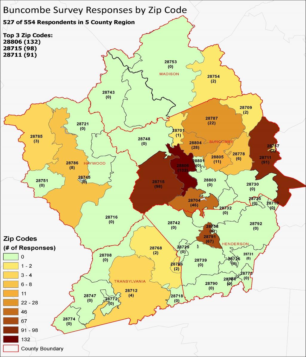
5 SURVEY RESULTS BUNCOMBE COUNTY The Buncombe County survey was taken by 595 people- the third most of the five counties. This was somewhat surprising due to Buncombe County having the largest population of the five counties as well as having the best access to internet. However, the Buncombe County survey was open for a shorter time period than other counties and social media promotions did not last as long in Buncombe County as compared to other counties. In general, most projects in Buncombe County received a positive response from survey users, with the exception of the Superstreet Project on US 25/70 in both Buncombe and Madison counties. The US 25/70 project had a barely positive score (0.17) with 33.3 of respondents rating the project positively and 30.4 of respondents rating the project negatively. Between modes, bike/ped projects were more positively received than highway projects (with several exceptions) and had more responses than highway projects. The worst scoring bike/ped project was the US 70 Road Diet project which had roughly twice as many negative responses as any other bike/ped project. However, it should be noted that the US 70 Road Diet was still very well received with an average score of 2.49, 74.6 of respondents rating the project positively, and 12.7 of respondents rating the project negatively. County Transylvania 910 Henderson 613 Buncombe 595 Madison 209 Haywood 160 Respondents The map on the following page shows the respondents for the Buncombe County survey by zip code. 527 of the 554 respondents live or travel within the 5 county region. The charts following show the survey results of each individual project, first with results from the short survey and then the deep dive results.
6

7 MODERNIZATION WIDENING SHORT SURVEY RESULTS PRESENTED HERE ARE CATEGORIZED INTO MODERNIZATION, WIDENING AND INTERSECTION/ACCESS MANAGEMENT. INTERSECTION
8 DEEP DIVE RESULTS BUNCOMBE Project County Mode Tier NC 251 Greenway Buncombe Bike/Ped Riverwalk Greenway Phase III Buncombe Bike/Ped Lake Julian/Bent Creek Greenway Buncombe Bike/Ped Fonta Flora Greenway Buncombe Bike/Ped Average Score Negative Negative Needs Needs Needs Needs of Response s Old Haywood Road Sidewalks Buncombe Bike/Ped Hominy Creek Greenway Buncombe Bike/Ped Johnston Blvd Sidewalks Buncombe Bike/Ped Sweeten Creek Road Buncombe Highway Mountain Mobility Buncombe Transit Blue Ridge Road Sidewalks Buncombe Bike/Ped Needs Needs Needs Impact Needs Needs
9 Project County Mode Tier Average Score Negative Negative of Response s I-40/I- 240/US 74A Buncombe Highway Mobility Clayton Road Buncombe Highway Needs Reems Creek Greenway Buncombe Bike/Ped NC 191 (Brevard Road) US 70 Road Buncombe, Henderson Highway Diet Buncombe Bike/Ped Swannanoa River Road Buncombe Highway I-2513A Buncombe Highway Long Shoals Buncombe Highway I-40 (I-26 to Sweeten Creek) Buncombe Highway Fairview Road Access Mgmt Buncombe Highway Mills Cane Creek Road Buncombe Highway Tunnel Road Buncombe Highway Needs Impact Needs Impact Mobility Impact Mobility Impact Needs Impact
10 Project County Mode Tier Average Score Negative Negative of Response s N Louisiana Ave Buncombe Highway Needs A-0010AB Buncombe Highway Mobility Ledbetter Road Buncombe Highway Needs Pond Road Buncombe Highway Needs Fanning Bridge Modernizat ion Buncombe, Henderson Highway Overlook Road Buncombe Highway I-40 (Liberty to Monte Vista) Buncombe Highway I-40 (Sweeten Creek to Patton Cove) Buncombe Highway New Route (Broadway to New Leicester) Buncombe Highway Needs Needs Mobility Mobility Needs I-40 (Wiggins to Liberty) Buncombe Highway Mobility
11 Project County Mode Tier I-40 (Wiggins to Monte Vista Buncombe Highway Weaverville Highway Buncombe Highway A-0010AC Buncombe Highway Average Score Negative Negative Mobility Impact Mobility of Response s Monte Sand Hill School Buncombe Highway Needs I-40 (Wiggins to Champion) Buncombe, Haywood Highway Mobility Blue Ridge Road Buncombe Highway Enka Lake Road Buncombe Highway Porter's Cove Road Buncombe Highway Emma/Ben Lippen Road Buncombe Highway NC 151 (Pisgah Hwy) Buncombe Highway Needs Needs Mobility Needs Impact
12 Project County Mode Tier US 25/US 70 Buncombe, Superstreet Madison Highway Average Score Negative Negative Impact of Response s Color-coding information can be seen in the Appendix at the end of this report.
13 HAYWOOD COUNTY The Haywood County survey was taken by 160 people- the fewest respondents of the five counties, despite being the third most populous of the five counties. The survey for Haywood County, unlike Buncombe and Henderson counties had only a deep-dive section. The shortened section was left out County Transylvania Henderson Buncombe Respondents due to the deep-dive only having eleven projects for respondents to Madison 209 choose from. Haywood 160 On average, proposed projects in Haywood County were positively rated. Two proposed projects on I-40 were the highest rated in the County with a project on US 276 (Russ Avenue) between US 23/74 and US 19 (Dellwood Road) scoring relatively highly as well. Two projects received somewhat middling ratings from survey users: a project to modernize US 276 (Jonathan Creek Road) and a project to modernize NC 209. While neither project was as positively received as others in the County, both projects still had more positively responses than negative. The map on the following page shows the respondents for the Haywood County survey by zip code. 150 of the 160 respondents live or travel within the 5 county region. The charts following show the survey results of each individual project.

14
15 DEEP DIVE RESULTS - HAYWOOD Project County Mode Tier I-40 (Wiggins to Champion) Haywood, Buncombe Highway Average Score Negative Negative Mobility of Respon ses I-40 (Champion to US 23/74) Haywood Highway US 276 (Russ Avenue) Haywood Highway US 23/74 (Great Smoky Mtn Expressway) from I-40 to US 276 Haywood Highway US 19 (Dellwood Road) Haywood Highway US Crimes Cove Road Haywood Highway US 19 (Soco Road) Haywood Highway Mobility Impact Mobility Impact Impact Impact US 19/23 Modernization Haywood Highway Impact
16 Project County Mode Tier US 23/74 (Great Smoky Mtn Expressway) from S Main to Balsam View Dr. Haywood Highway US 276 (Jonathan Creek Road) Haywood Highway NC 209 Modernization Haywood Highway Average Score Negative Negative Mobility of Respon ses Impact Impact Color-coding information can be seen in the Appendix at the end of this report.
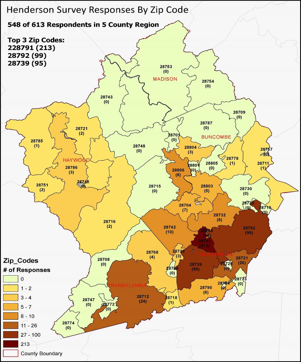
17 HENDERSON COUNTY The Henderson County survey was taken by 613 people- the second most of the five counties. The Henderson County survey had both the shortened survey and the deep-dive options due to the number of projects being considered in the county. County Respondents Transylvania 910 Henderson 613 Buncombe 595 As background, Henderson County had been experiencing considerable public opposition to several funded transportation projects in the County, including the Balfour Parkway, Kanuga Road, and North Highland Lake Madison Haywood Road. More opposition was seen in response to several proposed projects in Henderson County, including Balfour Parkway Sections A & C and two proposed widenings of NC 191. The two sections of Balfour Parkway and the section of NC 191 between US 25-Business and Mountain Road were the most negatively rated projects in the entire region. Across modes, bike/ped projects were received much more positively than highway projects, with exceptions for a proposed widening on I-26 (from US 64 to US 25) and the Flat Rock Greenway. The proposed widening of I- 26 was received the most positively of any highway project in Henderson County with 81.3 of users rating the project positively and only 15.6 of users rating project negatively. The Flat Rock Greenway was the most negatively received bike/ped project but still had 66.2 of users rating the project positively and 24.8 of users rating the project negatively. The map on the following page shows the respondents for the Henderson County survey by zip code. 548 of the 613 respondents live or travel within the 5 county region. The charts following show the survey results of each individual project, first with results from the short survey and then the deep dive results.
18


19 SHORT SURVEY RESULTS FOR HENDERSON COUNTY PRESENTED HERE ARE CATEGORIZED INTO MODERNIZATION AND WIDENING. NUMBER NEXT TO BAR LINE DENOTES NUMBER OF RESPONDENTS. WIDENING MODERNIZATION
20 DEEP DIVE RESULTS HENDERSON Negati ve Project County Mode Tier Average Score Negative Oklawaha Greenway (Berkley Park to Brookside Camp Road) Henderson Bike/Ped Needs French Broad River Bridge Henderson Bike/Ped Needs of Respon ses Oklawaha Greenway (Westfeldt Park to Butler Bridge Road) Henderson Bike/Ped Oklawaha Greenway (Jackson Park to BRCC) Henderson Bike/Ped I-26 Henderson Highway Grove Street Sidewalks Henderson Bike/Ped NC 280 MUP (French Broad River to N Mills River Rd) Henderson Bike/Ped NC 280 MUP (N Mills River Rd to NC 191) Henderson Bike/Ped Flat Rock Greenway Henderson Bike/Ped Needs Needs Mobility Needs Needs Needs Needs
21 Negati ve Project County Mode Tier Average Score Negative Banner Farm School House Rd Henderson Highway Needs Fanning Bridge Henderson, Modernization Buncombe Highway Needs Duncan Hill Road Henderson Highway Needs Butler Bridge Road Henderson Highway Needs NC 280 Henderson Highway Impact NC 225 Henderson Highway Impact Blythe Street Henderson Highway Needs White Pine Drive Henderson Highway Needs N Rugby Road Henderson Highway Needs NC 191 (NC 280 to NC 146) Henderson Highway Impact NC 191 (Mountain Road to US 25B) Henderson Highway Balfour Pkwy (I- 26 to US 64) Henderson Highway Balfour Pkwy (NC 191 to US 25B) Henderson Highway of Respon ses Impact Needs Needs Color-coding information can be seen in the Appendix at the end of this report.
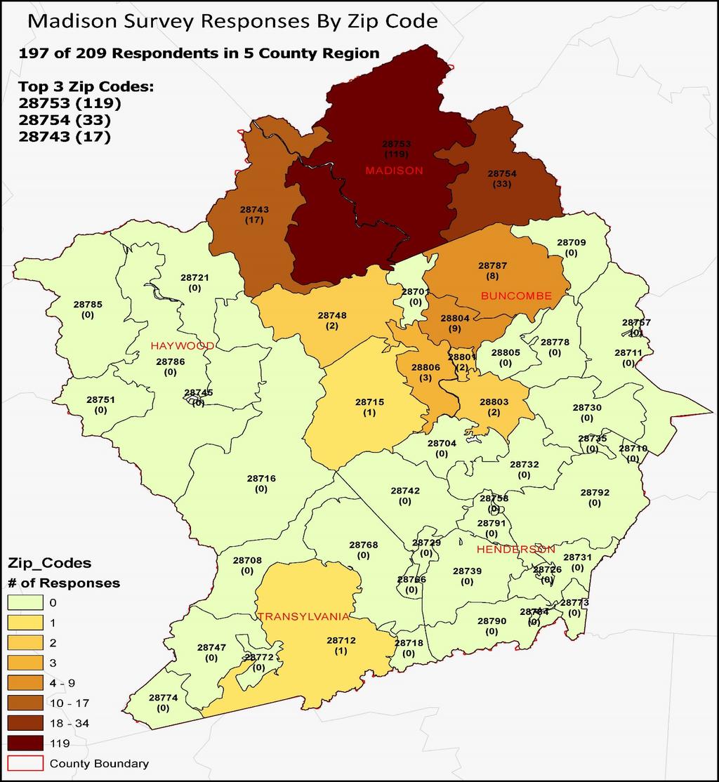
22 MADISON COUNTY The Madison County survey was taken by 209 people- the second fewest respondents of the five counties, however it is the least populous of all the counties. The survey for Madison County, unlike Buncombe and Henderson counties had only a deep-dive section. The shortened section was left out due to the deep-dive only having six projects for respondents to choose from. County Respondents Transylvania 910 Henderson 613 Buncombe 595 Madison 209 Haywood 160 On average, proposed projects in Haywood County were positively rated. The US70/25 Modernization was the highest rated in the County by over 0.60 points on average. The Crossroads Parkway and NC 208 modernization projects followed the top ranking project. The Spring Creek Connector project received only around 60 positive support but drew over 30 of negative votes. It is worth noting that this project had only 155 responses out of 209 respondents. The map on the following page shows the respondents for the Madison County survey by zip code. 197 of the 209 respondents live or travel within the 5 county region. The charts following show the survey results of each individual project.
23
24 DEEP DIVE RESULTS MADISON Project US 70/25 Modernization County Madison Crossroads Pkwy Madison NC 208 Modernization (US 25/70 to NC 212) Madison NC 208 Modernization (NC 212 to Tennessee) Madison Spring Creek Connector US 25/70 Superstreet Madison Madison, Buncombe Mod e High way High way High way High way High way High way Positi ve Positi ve Neutr al Neutr al Negati ve Tier Average Score Nega tive Impact Needs Impact Impact Needs Impact of Response s Color-coding information can be seen in the Appendix at the end of this report.
25 TRANSYLVANIA COUNTY The Transylvania County survey was taken by 910 people- the most respondents of the region, and it is second to least populous of the five county region. The survey for Transylvania County, similar to Madison and Haywood counties had only a deep-dive section. The shortened section was left out due to the deep-dive having twenty one projects for respondents to choose from. County Respondents Transylvania 910 Henderson 613 Buncombe 595 Madison 209 Haywood 160 On average, proposed projects in Transylvania County were overwhelmingly positively rated. Three projects (All Bike/Pedestrian) had over a 2.90 average score: Neely Road MUP, Tannery Park MUP, Main St MUP. The highest scoring highway project was Neely/Park/Parkview at Important to note that the highest scoring projects also had the highest number of responses. The only project to have a negative average score was the West Loop new route proposal. ~50 or 187 of respondents voted positively for the project however 47 or 177 of the respondents voted negatively, with most of these responses being a -5 or the lowest possible score. The map on the following page shows the respondents for the Transylvania County survey by zip code. 806 of the 910 respondents live or travel within the 5 county region. This does not include respondents who skipped the zip code question. The charts following show the survey results of each individual project.

26
27 DEEP DIVE RESULTS TRANSYLVANIA Project County Mode Tier Neely Road to Broad Street MUP Transylvania Bike/Ped Tannery Park MUP Transylvania Bike/Ped Main St to Hillview St MUP Transylvania Bike/Ped Railroad Avenue MUP Transylvania Bike/Ped US 64 MUP Transylvania Bike/Ped Music Camp Road MUP Transylvania Bike/Ped Neely/Park/Par kview Transylvania Highway Main Street MUP Transylvania Bike/Ped Old US 64 Modernization Transylvania Highway Ecusta Road Transylvania Highway Hillview Circle to Norton Creek MUP Transylvania Bike/Ped Old Rosman Hwy MUP Transylvania Bike/Ped NC 280 Transylvania Highway Average Score Negati ve Negati ve Needs Needs Needs Needs Needs Needs Needs Needs Needs Needs Needs Needs Impact of Response s
28 Project County Mode Tier North Country Club Road Transylvania Highway South Broad Street Intersection Realignment Transylvania Highway Pickens Highway Modernization Transylvania Highway Everette Farms Road Transylvania Highway Rosman Hwy Widening Transylvania Highway US 64 Roadway Improvement Transylvania Highway Balsam Grove Roadway Project Transylvania Highway West Loop New Route Transylvania Highway Average Score Negati ve Negati ve Needs Impact Impact Needs Impact Impact Impact Needs of Response s Color-coding information can be seen in the Appendix at the end of this report.
29 COMMENT SUMMARY The last question for each counties survey provided an opportunity to submit comments about any proposed project or the survey process. A general summary of those comments for each county follows. BUNCOMBE 75 out of 595 respondents chose to provide comments 29 comments were in general support bike/ped initiatives 5 comments in support of complete streets as part of roadway projects 4 comments in support of better transit options HAYWOOD 33 out of 160 respondents chose to provide comments 13 comments mentioned approval of bike lanes, sidewalks and/or complete streets policies Over 10 comments were in support of widening I-40 6 comments considered the Raccoon Rd/Pigeon Rd intersection a high priority HENDERSON 109 out of 611 respondents chose to provide comments Over 50 of the comments were in disapproval of the Balfour Parkway project 10 comments mentioned approval of bike lanes, sidewalks and/or complete streets policies 5 comments disapprove of all roadway projects and improvements MADISON 51 out of 209 respondents chose to provide comments Over 15 comments disapprove of any NC 208 improvements Over 5 comments support maintenance of existing roads 5 comments approve of sidewalks and/or complete streets policies
30 TRANSYLVANIA 149 out of 910 respondents chose to provide comments 26 comments oppose west loop 22 comments support greenways or multi-use paths 10 comments support projects overall
31 METHODS REVIEW The FBRMPO and LOSRPO staff conclude that the survey was a success overall and it is helpful in illustrating public response about transportation projects. The number of surveys received was an exponential increase since last round of prioritization, P 4.0. This is likely due to an increase in awareness of transportation projects, an increased demand to be involved in community-based planning and the distribution efforts of all organizations involved. It is particularly encouraging that some of less publicly involved communities such as Transylvania County and Henderson County saw an increase in responses, particularly open-ended comments. Although the survey had an increased response rate, there are multiple ways the survey itself and the outreach efforts could be improved. While the survey reached 2, 487 people, that is still only around 0.50 of the five county population (480,051 people). A reasonable goal would be to reach 1 of the population with the next survey. However, according to Survey Monkeys recommended sample size, we reached a 99 confidence level with a margin of error of 2.5 which is suitable for the purposes of this survey. Another area of improvement could be using different outlets to help engage disadvantaged and/or underserved segments of the population. Transportation projects have historically impacted disadvantaged communities the most, elevating the importance of their concerns. After reviewing many of the open-ended comments, it was clear that many respondents were from similar geographic or socioeconomic regions. One way to improve the reach of the survey is to make paper copies available in public spaces. MPO and RPO staff holding survey sessions at community spaces such as churches, coffee shops and libraries could offer an opportunity to connect with residents as well. This is important not only for gathering input on the survey, but also for establishing or maintaining relationships with leaders in the community. The MPO can use the Citizens Advisory Committee (CAC) to determine better outreach strategies.
32 French Broad Metropolitan Planning Organization Lyuba Zuyeva, Director Tristan Winkler, Senior Transportation Planner Land of Sky Rural Planning Organization Vicki Eastland, RPO Coordinator Nick Kroncke, Planner Nick Kroncke, Planner 339 New Leicester Hwy, Suite New Leicester Hwy, Suite 140 Asheville, NC Asheville, NC
33 APPENDIX: ALL DEEP-DIVE RESULTS ABOUT THE DEEP-DIVE RESULTS Average Score Negative Negative of Responses Average score Percent of Percent of Percent of given to a users users users Number of Number of Number of project by responding to Number of responding to responding to users that gave users that gave people that survey users a specific users that gave a specific a specific a project a a project a actively gave each user project that a project a project that project that score of +1 to score of 1 to the project a could score a gave the score of 0 gave the gave the +5 5 response project from 5 project a score project a score project a score to +5 of +1 to +5 of 0 of 1 to 5 VISUAL LEGEND Average Score Negative Negative of Responses >2.50 > <25 <25 >400 >1.00 > >25 >250 No Color No Color Coding Coding > 1.00 >99 >25 >50 >50 >150 < 1.00 <100 <25 >100 >75 <150
34 Project County Mode Tier NC 251 Greenway Buncombe Bike/Ped Riverwalk Greenway Phase III Buncombe Bike/Ped Oklawaha Greenway (Berkley Park to Brookside Camp Road) Henderson Bike/Ped Average Score Neg ative Negat ive of Respon ses Needs Needs Needs Lake Julian/Bent Creek Greenway Buncombe Bike/Ped Neely Road to Broad Street MUP Transylvania Bike/Ped Fonta Flora Greenway Buncombe Bike/Ped Tannary Park MUP Transylvania Bike/Ped Main St to Hillview St MUP Transylvania Bike/Ped Old Haywood Road Sidewalks Buncombe Bike/Ped Hominy Creek Greenway Buncombe Bike/Ped Johnston Blvd Sidewalks Buncombe Bike/Ped Railroad Avenue MUP Transylvania Bike/Ped Needs Needs Needs Needs Needs Needs Needs Needs Needs
35 Project County Mode Tier Average Score Neg ative US 64 MUP Transylvania Bike/Ped Needs French Broad River Bridge Henderson Bike/Ped Needs Oklawaha Greenway (Westfeldt Park to Butler Bridge Road) Henderson Bike/Ped Oklawaha Greenway (Jackson Park to BRCC) Henderson Bike/Ped Music Camp Road MUP Transylvania Bike/Ped Sweeten Creek Road Buncombe Highway Mountain Mobility Buncombe Transit Blue Ridge Road Sidewalks Buncombe Bike/Ped I 26 Henderson Highway Grove Street Sidewalks Henderson Bike/Ped Neely/Park/Parkvi ew Transylvania Highway I 40/I 240/US 74A Buncombe Highway Clayton Road Buncombe Highway Negat ive of Respon ses Needs Needs Needs Impact Needs Needs Mobility Needs Needs Mobility Needs
36 Project County Mode Tier Average Score Neg ative Reems Creek Greenway Buncombe Bike/Ped Needs NC 191 (Brevard Buncombe, Road) Henderson Highway Impact Main Street MUP Transylvania Bike/Ped Needs US 70 Road Diet Buncombe Bike/Ped Needs Swannanoa River Road Buncombe Highway Impact Old US 64 Modernization Transylvania Highway Needs I 2513A Buncombe Highway Mobility Ecusta Road Transylvania Highway NC 280 MUP (French Broad River to N Mills River Rd) Henderson Bike/Ped Long Shoals Buncombe Highway NC 280 MUP (N Mills River Rd to NC 191) Henderson Bike/Ped Hillview Circle to Norton Creek MUP Transylvania Bike/Ped Old Rosman Hwy MUP Transylvania Bike/Ped Negat ive of Respon ses Needs Needs Impact Needs Needs Needs
37 Project County Mode Tier Average Score Neg ative US 70/25 Modernization Madison Highway Impact NC 280 Transylvania Highway Impact I 40 (I 26 to Sweeten Creek) Buncombe Highway Mobility Fairview Road Access Mgmt Buncombe Highway Impact Mills Cane Creek Road Buncombe Highway Needs I 40 (Wiggins to Haywood, Champion) Buncombe Highway Mobility I 40 (Champion to US 23/74) Haywood Highway Mobility Tunnel Road Buncombe Highway Impact N Louisiana Ave Buncombe Highway Needs A 0010AB Buncombe Highway Mobility Ledbetter Road Buncombe Highway Needs Pond Road Buncombe Highway Needs North Country Club Road Transylvania Highway Needs Fanning Bridge Buncombe, Modernization Henderson Highway Needs Overlook Road Buncombe Highway Negat ive of Respon ses Needs
38 Project County Mode Tier I 40 (Liberty to Monte Vista) Buncombe Highway I 40 (Sweeten Creek to Patton Cove) Buncombe Highway New Route (Broadway to New Leicester) Buncombe Highway I 40 (Wiggins to Liberty) Buncombe Highway I 40 (Wiggins to Monte Vista Buncombe Highway US 276 (Russ Avenue) Haywood Highway Weaverville Highway Buncombe Highway A 0010AC Buncombe Highway South Broad Street Intersection Realignment Transylvania Highway Pickens Highway Modernization Transylvania Highway Monte Sand Hill School Buncombe Highway Everette Farms Road Transylvania Highway Crossroads Pkwy Madison Highway Flat Rock Greenway Henderson Bike/Ped Average Score Neg ative Negat ive of Respon ses Mobility Mobility Needs Mobility Mobility Impact Impact Mobility Impact Impact Needs Needs Needs Needs
39 Project County Mode Tier I 40 (Wiggins to Buncombe, Champion) Haywood Highway NC 208 Modernization (US 25/70 to NC 212) Madison Highway Rosman Hwy Widening Transylvania Highway NC 208 Modernization (NC 212 to Tennessee) Madison Highway Blue Ridge Road Buncombe Highway Banner Farm School House Rd Henderson Highway Enka Lake Road Buncombe Highway US 64 Roadway Improvement Transylvania Highway I Porter's Cove Road Buncombe Highway US 23/74 (Great Smoky Mtn Expressway) from I 40 to US 276 Haywood Highway US 19 (Dellwood Road) Haywood Highway US Crimes Cove Road Haywood Highway Average Score Neg ative Negat ive of Respon ses Mobility Impact Impact Impact Needs Needs Needs Impact Mobility Mobility Impact Impact
40 Project County Mode Tier Average Score Neg ative Emma/Ben Lippen Road Buncombe Highway Needs Fanning Bridge Henderson, Modernization Buncombe Highway Needs US 19 (Soco Road) Haywood Highway Impact Duncan Hill Road Henderson Highway Needs Spring Creek Connector Madison Highway Needs US 19/23 Modernization Haywood Highway Impact US 23/74 (Great Smoky Mtn Expressway) from S Main to Balsam View Dr. Haywood Highway Butler Bridge Road Henderson Highway US 276 (Jonathan Creek Road) Haywood Highway NC 151 (Pisgah Hwy) Buncombe Highway NC 280 Henderson Highway Balsam Grove Roadway Project Transylvania Highway NC 225 Henderson Highway Blythe Street Henderson Highway Negat ive of Respon ses Mobility Needs Impact Impact Impact Impact Impact Needs
41 Project County Mode Tier Average Score Neg ative White Pine Drive Henderson Highway Needs N Rugby Road Henderson Highway Needs NC 209 Modernization Haywood Highway Impact US 25/US 70 Buncombe, Superstreet Madison Highway Impact NC 191 (NC 280 to NC 146) Henderson Highway Impact US 25/70 Madison, Superstreet Buncombe Highway Impact West Loop New Route Transylvania Highway Needs NC 191 (Mountain Road to US 25B) Henderson Highway Impact Balfour Pkwy (I 26 to US 64) Henderson Highway Needs Balfour Pkwy (NC 191 to US 25B) Henderson Highway Negat ive of Respon ses Needs
PROPOSED PARK ALTERNATIVES
 8 Chimne y Rock State Park M a ster Pl an 2011 PROPOSED PARK ALTERNATIVES Introduction Three different park development concepts were prepared and presented to the citizens of North Carolina through a
JATA Market Research Study Passenger Survey Results
 JATA Market Research Study Passenger Survey Results Prepared for the Jackson Area Transportation Authority (JATA) April, 2015 3131 South Dixie Hwy. Suite 545 Dayton, OH 45439 937.299.5007 www.rlsandassoc.com
Asheville & WNC Hikes
 Asheville & WNC Hikes Amazingly, we have 3,000+ miles of free public hiking trails near Asheville, including 1,600 miles in the Pisgah and Nantahala National Forests, 850 miles in Great Smokey Mountains
SR 934 Project Development And Environment (PD&E) Study
 Study") SR 934 Project Development And Environment (PD&E) Study Project Advisory Group Meeting March 1, 2018 State Road 934/NE/NW 79th Street from west of I-95 (NW 13th CT) to N. Bayshore Drive PD&E STUDY SR 934/NE/NW
SR 934 Project Development And Environment (PD&E) Study Project Advisory Group Meeting March 1, 2018 State Road 934/NE/NW 79th Street from west of I-95 (NW 13th CT) to N. Bayshore Drive PD&E STUDY SR 934/NE/NW
N. Central St. & W. Jackson Ave. Streetscape Projects
 N. Central St. & W. Jackson Ave. Streetscape Projects October 13, 2016 Meeting Overview North Central Street City of Knoxville KUB History & Vision Plan Timing Project Area Overview Schedule Communications
Chapel Hill Transit: Short Range Transit Plan. Preferred Alternative DRAFT
 : Short Range Transit Plan Preferred Alternative August 2018 Table of Contents Executive Summary... 1 Preferred Alternative... 3 Best Practices for Route Design... 3 Project Goals... 4 Preferred Alternative...
OR MISSION TRAIL ELEMENTARY
 Leawood: overview OVERLAD PARK 24: p.70 I-LA PARK 32: p.72 TOMAHAWK PARK 23: p.69 31: p.71 GEZER PARK OR MISSIO TRAIL ELEMETARY 22: p.68 W 133rd St W 135th St KASAS CITY MO - other segments Beginning/end
Mohawk Hudson Bike Hike Trail Crossroad Connection Study
 Summary Report - April 21, 2003 Mohawk Hudson Bike Hike Trail Crossroad Connection Study Summary Report Introduction The Capital District Transportation Committee (CDTC), in partnership with Albany County,
Welcome to the Cross County Trail Public Input Session!
 Welcome to the Cross County Trail Public Input Session! Please sign in on the table below! What are we doing here? Camden County has proposed a bicycle and pedestrian trail spanning across the entire county.
Engagement Summary Report. Trans-Canada Highway 1 RW Bruhn Bridge Replacement Project. Community Engagement November 15, 2016 to January 15, 2017
 Trans-Canada Highway 1 RW Bruhn Bridge Replacement Project Community Engagement November 15, 2016 to January 15, 2017 Engagement Summary Report February 2017 Prepared by Kirk & Co. Consulting Ltd. Trans-Canada
New 55-Dogpatch Outreach Findings & Route Development
 Executive Summary Based on outreach conducted through Spring of 2018, the SFMTA identified a set of three alternative routes and service plans for a new 55-Dogpatch route. These alternatives respond to
DEMOGRAPHICS AND EXISTING SERVICE
 EXECUTIVE SUMMARY The Central Corridor light-rail transit (LRT) project will open in 2014 and operate between downtown Minneapolis and downtown St. Paul, serving the University of Minnesota and University
ONONDAGA CREEKWALK PHASE II. Public Information Meeting Series 1
 ONONDAGA CREEKWALK PHASE II Public Information Meeting Series 1 Andrew Maxwell Director, Syracuse-Onondaga County Planning Agency Owen Kerney Assistant Director for City Planning Russell Houck, PE City
Non-Motorized Transportation
 Non-Motorized Transportation Non-motorized facilities are important components to the transportation system. They provide an environmentally-friendly, low-cost mode of travel. Some of the facilities can
Food Finder as of February 2016
 Agency 00931 FEEDING AVERY FAMILIES Food Pantry (828) 260-6043 130 Montezuma St. Newland 28657 Avery Last Wednesday of Month, 9:00am - (Except for November & December) 00412 REACHING AVERY MINISTRY Food
May 2017 Buncombe UCC. Photo taken in Louisburg, NC
 May 2017 Buncombe UCC Photo taken in Louisburg, NC WE DIG DATA Just take a look Locate Requests & Transmissions Apr. 2017 vs 2016 Tickets 2017: 156,103 2016: 161,633 Difference: -3.4% Transmissions 2017:
Memo. Orange City Trail Plan Becky Mendez, AICP Jamie Krzeminski, PE, PTOE Matt Wiesenfeld, PE, AICP. Development of the Existing and Proposed Network
 Memo Date: Friday, December 22, 2017 Project: To: From: Subject: Trail Plan Becky Mendez, AICP Jamie Krzeminski, PE, PTOE Matt Wiesenfeld, PE, AICP Development of the Existing and Proposed Network HDR
Food Finder as of November 2016
 Name Type Phone Address City Zip County Hours 00931 FEEDING AVERY FAMILIES Food Pantry (828) 260-6043 130 Montezuma St. Newland 28657 Avery Last Wednesday of Month, 9:00am - 12:00pm (Except for November
ACRP 01-32, Update Report 16: Guidebook for Managing Small Airports Industry Survey
 ACRP 01-32, Update Report 16: Guidebook for Managing Small Airports Industry Survey Goal of Industry Survey While there are common challenges among small airports, each airport is unique, as are their
University Region Non-Motorized Plan 2015
 Non-Motorized Transportation Non-motorized facilities are important components to the transportation system. They provide an environmentally-friendly, low-cost mode of travel. Some of the facilities can
2013 Business & Legislative Session Visitor Satisfaction Survey Results
 2013 Business & Legislative Session Visitor Satisfaction Survey Results Completed by Juneau Economic Development Council in partnership with The Alaska Committee August 2013 JEDC research efforts are supported
EAKINS OVAL / 25 TH & PENNSYLVANIA AREA PROJECT SUMMARY 1
 EAKINS OVAL / 25 TH & PENNSYLVANIA AREA PROJECT SUMMARY The Parkway Council Foundation is studying potential road and sidewalk reconfigurations of two areas at the western edge of the Benjamin Franklin
Food Finder as of December 2016
 00931 FEEDING AVERY FAMILIES Food Pantry (828) 260-6043 130 Montezuma St. Newland 28657 Avery Last Wednesday of Month, 9:00am - 12:00pm (Except for November & December) 00412 REACHING AVERY MINISTRY Food
Appendix B Listening Session I & II Summaries
 Appendix B Listening Session I & II Summaries Lextran COA Listening Session I September 8, 2014 Lexington Main Public Library Conference Room A 4:00 PM to 7:00 PM Comment Summaries Schedule / Service Area
Committee. Presentation Outline
 CW-33-15 11/9/2015 Community and Corporate Services Committee November 10, 2015 1 Presentation Outline Background Vision and Objectives Study Process and Timeline Public and Stakeholder Engagement Organization
A Master Plan is one of the most important documents that can be prepared by an Airport.
 The Master Plan A Master Plan is one of the most important documents that can be prepared by an Airport. A Master Plan is a visionary and a strategic document detailing planning initiatives for the Airport
Selecting A Great Trek. January Advisor Briefing
 Selecting A Great Trek January Advisor Briefing 1 Selecting A Great Trek The November presentation was designed to introduce you to Philmont and its history. Tonight we will discuss the process of choosing
North Shore Area Transit Plan
 North Shore Area Transit Plan North Shore Area Transit Plan Phase 3 Consultation Report Contents 1 Overview of the North Shore Area Transit Plan...1 2 Phase 3 Consultation...1 3 Phase 3, Stage 1: Confirming
TransAction Overview. Introduction. Vision. NVTA Jurisdictions
 Introduction Vision NVTA Jurisdictions In the 21 st century, Northern Virginia will develop and sustain a multimodal transportation system that enhances quality of life and supports economic growth. Investments
EXECUTIVE SUMMARY FALL Introduction. Findings
 EXECUTIVE SUMMARY FALL 2004 Introduction Trails are one of the most popular and highly desirable recreational resources in communities of all sizes throughout the country. In addition to providing a safe
All questions in this survey were voluntary; all results are based on number of respondents who answered the relevant question.
 Online Survey Results Sound Transit 3 Draft Plan Introduction An online survey was one of the primary methods employed to solicit feedback on Sound Transit 3 Draft Plan. The results of the March 29 May
Service Change Plan Cowichan Valley Regional Transit System July 2018 Expansion. Prepared by
 Service Change Plan Cowichan Valley Regional Transit System July 18 Expansion Prepared by OVERVIEW In order to continue delivering on the Cowichan Valley Transit Future Plan goals and objectives and to
THAT the Board approve the final proposed concept plan for the Jericho Marginal Wharf site as shown in Figure C-4 of Appendix C.
 Date: January 17, 2012 TO: Board Members Vancouver Park Board FROM: General Manager Parks and Recreation SUBJECT: Jericho Marginal Wharf Phase 2 Concept Plan RECOMMENDATION THAT the Board approve the final
Waterfront Concept Plan: Community Survey Summary
 Waterfront Concept Plan: Community Survey Summary Published April 20, 2016 #1100085 Introduction The survey was one component of the public consultation process endorsed by Council in October, 2015. This
Travel Model Blind Spots: The Importance of Understanding Special Markets Related to Visitors
 Huntsinger and Ward 1 1 2 3 4 5 6 7 8 9 10 11 12 13 14 15 16 17 18 19 20 21 22 23 24 25 26 27 28 29 30 31 32 33 34 Travel Model Blind Spots: The Importance of Understanding Special Markets Related to Visitors
user s guide to Transportation Improvements in Astoria Planning Efforts outside Astoria for more information, contact:
 The Miles Crossing/ Jeffers Garden transportation plan (underway), will identify needed improvements to the Warrenton Astoria Highway and local street improvements to serve expected growth in the Miles
IL 390 Station. Wood Dale Open House Summary 5/18/17
 Wood Dale Open House Summary 5/18/17 The first public open house for the Wood Dale Comprehensive Plan took place on May 18 th, 2017. The program was conducted as a fun community event and there were 216
12, 14 and 16 York Street - Amendments to Section 16 Agreement and Road Closure Authorization
 REPORT FOR ACTION 12, 14 and 16 York Street - Amendments to Section 16 Agreement and Road Closure Authorization Date: April 27, 2018 To: Toronto and East York Community Council From: Senior Strategic Director,
Food Finder as of January 2019
 00931 FEEDING AVERY FAMILIES Food Pantry (828) 873-8506 508 Pineola Street Newland 28657 Avery Last Friday of the Month, 9:00am - 00412 REACHING AVERY MINISTRY Food Pantry (828) 733-5127 147 New Vale Road
SASP Advisory Committee Meeting #3
 SASP Advisory Committee Meeting #3 MnDOT Office of Aeronautics #FlyMN www.minnesotago.org 1 Agenda Public Involvement Plan Update Defining the System Classification Review Minimum System Objectives Performance
Food Finder as of April 2018
 00931 FEEDING AVERY FAMILIES Food Pantry (828) 873-8506 508 Pineola Street Newland 28657 Avery Last Friday of the Month, 9:00am - 00412 REACHING AVERY MINISTRY Food Pantry (828) 733-5127 147 New Vale Road
Engagement Summary Report. Trans-Canada Highway 1 RW Bruhn Bridge and Approaches Project Community Engagement February 1 18, 2018.
 Trans-Canada Highway 1 RW Bruhn Bridge and Approaches Project Community Engagement February 1 18, 2018 Engagement Summary Report April 2018 Prepared by Kirk & Co. Consulting Ltd. Trans-Canada Highway 1
This document is being shared by the Parks, Recreation and Musuem Advisory Board at the request of Golden citizens and in order to be transparent
 This document is being shared by the Parks, Recreation and Musuem Advisory Board at the request of Golden citizens and in order to be transparent about what documents and information was shared during
Blueways: Rivers, lakes, or streams with public access for recreation that includes fishing, nature observation, and opportunities for boating.
 Parks, Open Space and Trails PRINCE WILLIAM COUNTY 2008 COMPREHENSIVE PLAN TRAILS PLAN CONTENTS The components of the trails plan are: Intent Definitions Goals, Policies, and Action Strategies Trails Map
Transit Network Review translink.ca
 Transit Network Review 2017 TRANSIT NETWORK REVIEW 2017 Table of Contents OVERVIEW... 1 PUBLIC AND STAKEHOLDER ENGAGEMENT... 2 OUTREACH AND ENGAGEMENT AT A GLANCE... 3 NEXT STEPS...4 WHAT WE HEARD AND
Community Advisory Panel Meeting #
 Community Advisory Panel Meeting # 6 02.13.19.. Agenda Welcome and Introductions Community Conversations City Council Meeting Debrief Review Citywide Tunnel Video (North Portal Only) Churchill Pedestrian
MAJESTIC HIGHLANDS OF ASHEVILLE
 MAJESTIC HIGHLANDS OF ASHEVILLE Asheville s Premier, High-Elevation, Mountain-Top Property 795 ± Acres Buncombe County Western North Carolina SEALED BID AUCTION Followed by a live auction on June 21st
Section II. Planning & Public Process Planning for the Baker/Carver Regional Trail began in 2010 as a City of Minnetrista initiative.
 Section II Planning & Public Process Planning for the began in 2010 as a City of initiative. city staff began discussions with the Park District on the possibility of a north/south regional trail connection
China Creek North Park Upgrades and Glen Pump Station. Park Board Committee Meeting Monday, July 10, 2017
 China Creek North Park Upgrades and Glen Pump Station Park Board Committee Meeting Monday, July 10, 2017 Purpose The purpose of this presentation is to: Share the results of the public engagement processes;
Introduction. Project Overview
 Washington Blvd./Andora Widening Project Community Open House & Public Scoping Meeting Summary Wednesday, September 21, 2016 6:00 7:30 p.m. Vencil Brown Elementary School, Roseville Introduction On Wednesday,
TORONTO TRANSIT COMMISSION REPORT NO. SUBJECT: TORONTO-YORK SPADINA SUBWAY EXTENSION STATION NAMES IN THE CITY OF VAUGHAN
 TORONTO TRANSIT COMMISSION REPORT NO. MEETING DATE: February 29, 2011 SUBJECT: TORONTO-YORK SPADINA SUBWAY EXTENSION STATION NAMES IN THE CITY OF VAUGHAN ACTION ITEM RECOMMENDATIONS It is recommended that
CITY OF VAUGHAN EXTRACT FROM COUNCIL MEETING MINUTES OF JANUARY 25, 2011
 Item 1, Report No. 1, of the Priorities and Key Initiatives Committee, which was adopted without amendment by the Council of the City of Vaughan on January 25,. 1 RAPID TRANSIT UPDATE TORONTO-YORK SPADINA
Longmont to Boulder Regional Trail Jay Road Connection DRAFT FINAL REPORT
 Longmont to Boulder Regional Trail Jay Road Connection DRAFT FINAL REPORT December 2018 Project Summary Boulder County, Colorado, in partnership with the City of Boulder, is evaluating options for multi-use
BRR Leg 1 (4.0 miles, Easy)
") BRR Leg 1 (4.0 miles, Easy) Min 3881 Max 4948 Ascent +36 Descent -1027 0.0 Start (Grayson Highlands State Park Visitor Center) 4.0 Grayson Highlands State Park Office & Gate, on L (EZ 1) Leg Notes: Minimal
BRR Leg 1 (4.0 miles, Easy) Min 3881 Max 4948 Ascent +36 Descent -1027 0.0 Start (Grayson Highlands State Park Visitor Center) 4.0 Grayson Highlands State Park Office & Gate, on L (EZ 1) Leg Notes: Minimal
Henderson, Polk, Transylvania County UCC
 Henderson, Polk, Transylvania County UCC Meeting Minutes February 9, 2017 Present: Next meeting: PSNC Energy: Tony Woody, Rick Gosnell, Greg Roberts, Brian Jamerson, David Thompson, Alex Franklin, Mike
PLEASE READ Proposal for Sustainable Service
 IMPORTANT PLEASE READ 019 Proposal for Sustainable Service 019 Service Change Proposal IMPLEMENT A SUSTAINABLE NETWORK Everett Transit completed its Long Range Plan in May, and the plan was adopted by
Southsea Flooding and Coastal Erosion Risk Management Scheme
 Southsea Flooding and Coastal Erosion Risk Management Scheme Public Consultation Report 3 rd November 29th December 2014 TABLE OF CONTENTS 1 INTRODUCTION... ERROR! BOOKMARK NOT DEFINED. 1.1 Purpose of
Chapter 6 Existing and Proposed Transportation Facilities
 Chapter 6 Existing and Proposed Transportation Facilities Methodology As discussed in Chapter 4, the Dixie MPO s CUBE modeling platform was used to analyze future traffic demand. The CUBE Model applied
Chapter 1: Introduction Draft
 Chapter 1: Draft TABLE OF CONTENTS 1... 4 1.6.1 Stakeholder Engagement Plan... 10 Chapter 1 Page 2 TABLE OF EXHIBITS Exhibit 1.1-1 ABIA Annual Growth Since 1993... 5 Exhibit 1.4-1: ABIA Location Map...
Measurement of the Economic Vitality of The Blue Ridge National Heritage Area
 Measurement of the Economic Vitality of The Blue Ridge National Heritage Area Section II Development and Implementation of an Industry-Wide Measuring Tool Designed to Assess Visitor Demographics, Psychographics,
2017 TBARTA Future Regional Priority Projects Adopted by TBARTA Board, December 9, 2016
 2017 TBARTA Future Regional Priority Projects Adopted by TBARTA Board, December 9, 2016 Project numbers do not signify ranking they are for mapping identification purposes only. 1. 15th Street East The
Sevierville, TN. Technical Appendices
 Sevierville, TN Technical Appendices 2017 2955 Valmont Road Suite 300 777 North Capitol Street NE Suite 500 Boulder, Colorado 80301 Washington, DC 20002 n-r-c.com 303-444-7863 icma.org 800-745-8780 Contents
Draft Year 2040 Cost Feasible Plan
 Year 2040 Plan Ranking of Desires Plan Projects And Matching of Available Revenues Palm Beach Metropolitan Planning Organization (MPO) Technical Advisory Committee (TAC) Citizens Advisory Committee (CAC)
Volunteer Trail Builders on NC s Mountains-to-Sea Trail. Kate Dixon Executive Director Friends of the Mountains-to-Sea Trail
 Volunteer Trail Builders on NC s Mountains-to-Sea Trail Kate Dixon Executive Director Friends of the Mountains-to-Sea Trail What I plan to cover today Overview of the Mountains-to-Sea Trail How we assist
Independence: overview
 : overview Kentucky Ave 8: p.30 SUGAR CREEK SATA FE. OREGO, CALIFORIA 7: p.29 6: p.28 9: p.31 10: p.32 Square, Jackson County Courthouse. Photo: Vireo Trail swale area, Santa Fe Trail. Photo: Vireo HISTORIC
AGENCY NAME TRANSPORTATION
 TRANSPORTATION TRANSPORTATION AGENCY NAME Prince William County FY 2015 BUDGET CIP-TRANSPORTATION 561 Fuller Road/Fuller Heights Road Improvements Total Project Cost - $4.4 M This project will widen Fuller
Culpeper District. Albemarle County Monthly Report December 2011
 Culpeper District Albemarle County Monthly Report Special Issues Construction Significant Accomplishments (as of 11/15/11) Georgetown Road completed on November 8. I-64 Eastbound Shadwell Exit completed
Agenda: SASP SAC Meeting 3
 Agenda: SASP SAC Meeting 3 Date: 04/12/18 Public Involvement Plan Update Defining the System Recommended Classifications Discussion Break Review current system Outreach what we heard Proposed changes Classification
MEETING MINUTES District 1 Trail Planning Meeting 1
 MEETING MINUTES District 1 Trail Planning Meeting 1 June 1, 2017 2:00 PM 3:30 PM City of Two Harbors 2:00 Introductions Attendees: Lisa Austin, MnDOT Bryan Anderson, MnDOT Jasna Hadzic-Stanek, MnDOT Justin
U.S. Travel Association Polling Presentation
 U.S. Travel Association Polling Presentation Key Points By greater than a 5-1 margin, adults say air travel has become more, not less, of a hassle over past five years. Similarly, adults see airline fees,
City of Fremantle. Joel Levin, Aha! Consulting INTRODUCTION 2 BACKGROUND 3
 -- WORKSHOP REPORT -- Project: Client: Event: South Beach Basketball Court City of Fremantle Community Consultation Forum Date: 12 th November 2015 6:00pm 8:00pm Author: Joel Levin, Aha! Consulting Contents:
35EXPRESS PROJECT UPDATE FOR DENTON COUNTY COMMISSIONERS
 35EXPRESS PROJECT UPDATE FOR DENTON COUNTY COMMISSIONERS 35EXPRESS PROJECT OVERVIEW 2 ABOUT THE 35EXPRESS PROJECT 3 DESIGN-BUILD TEAM 4 PROJECT PARTNERS Great partnerships make this project work Collaboration
South Coast Greenway Trail Alignment Study Symmes Road to Adamo Drive
 South Coast Greenway Trail Alignment Study Symmes Road to Adamo Drive Prepared for: Hillsborough County Metropolitan Planning Organization 601 East Kennedy Boulevard Tampa, FL 33602 (813) 272-5940 Prepared
FY Transportation Improvement Program. Ozarks Transportation Organization
 FY 2019-2022 Transportation Improvement Program Ozarks Transportation Organization LRTP TIP Construction TIP Transportation Improvement Program 4 year program of capital and non-capital surface transportation
Waukee Trailhead Public Art and Amenities Project
 Waukee - Trailhead Public Art and Amenities Project Sponsor Waukee Project Title Waukee Trailhead Public Art and Amenities Project Termini Description ( i.e. Park Avenue to 19th Street) NE Intersection
Public Workshop #1 Results Report. October 31, 2017
 Public Workshop # Results Report October 3, 07 Table of Contents Section : Introduction... 3 Section : Comment Card Responses... 4 Section 3: Additional Comments... 3 Section 4: Full Comment Summary...
Northern Virginia District State of the District. Helen L. Cuervo, P.E. District Engineer October 18, 2017
 Northern Virginia District State of the District Helen L. Cuervo, P.E. District Engineer October 18, 2017 Susan Shaw, P.E., Megaprojects Director Virginia Department of Transportation American Society
Trail Use in the N.C. Museum of Art Park:
 Trail Use in the N.C. Museum of Art Park: New Connections, New Visitors Jacqueline MacDonald Gibson, PhD Daniel Rodriguez, PhD Taylor Dennerlein, MSEE, MCRP, EIT Jill Mead, MPH Evan Comen University of
APPENDIX. I. Meeting Minutes and Presentations
 APPENDIX I. Meeting Minutes and Presentations Public Meeting Agenda 6:00-6:20 Welcome and Refreshments 6:20-6:40 Project Presentation 6:40-7:30 Facilitated Open House www.denvergov.org/parkprojects Please
Macleod Trail Corridor Study. Welcome. Macleod Trail Corridor Study Open House. Presentation of Proposed Design Concepts
 Macleod Trail Corridor Study Welcome Macleod Trail Corridor Study Open House Presentation of Proposed Design Concepts Study Purpose Develop a corridor plan for Macleod Trail that aligns with The City s:
Word Count: 3,565 Number of Tables: 4 Number of Figures: 6 Number of Photographs: 0. Word Limit: 7,500 Tables/Figures Word Count = 2,250
 Katherine F. Turnbull, Ken Buckeye, Nick Thompson 1 Corresponding Author Katherine F. Turnbull Executive Associate Director Texas Transportation Institute Texas A&M University System 3135 TAMU College
JOSLIN FIELD, MAGIC VALLEY REGIONAL AIRPORT DECEMBER 2012
 1. Introduction The Federal Aviation Administration (FAA) recommends that airport master plans be updated every 5 years or as necessary to keep them current. The Master Plan for Joslin Field, Magic Valley
Mount Pleasant (42, 43) and Connecticut Avenue (L1, L2) Lines Service Evaluation Study Open House Welcome! wmata.com/bus
 and Connecticut Avenue (L1, L2) Lines Service Evaluation Study Open House Welcome! wmata.com/bus") Mount Pleasant (42, 43) and Connecticut Avenue (L1, L2) Lines Service Evaluation Study Open House Welcome! Study Overview and Timeline Phase 1: Collect and Analyze Data Project Kickoff, September 2017
Mount Pleasant (42, 43) and Connecticut Avenue (L1, L2) Lines Service Evaluation Study Open House Welcome! Study Overview and Timeline Phase 1: Collect and Analyze Data Project Kickoff, September 2017
(This page intentionally left blank.)
") Executive Summary (This page intentionally left blank.) Executive Summary INTRODUCTION The Cache Valley Transit District (CVTD) contracted with the team of Transportation Consultants, Inc. () and Fehr
Executive Summary (This page intentionally left blank.) Executive Summary INTRODUCTION The Cache Valley Transit District (CVTD) contracted with the team of Transportation Consultants, Inc. () and Fehr
Ossington Station Easier Access Project - Construction & Public Art Concept Update
 Ossington Station Easier Access Project Construction & Public Art Concept Update Open House College/Shaw Library 1 Easier Access Program Wide Committed to making all stations accessible by 2025 34 stations
Citrus Heights Creek Corridor Trail Project Trail Advisory Group Field Trip #2 September 11, :00 11:00 am Trellis Hall, Citrus Heights
 September 11, 2013 9:00 11:00 am Trellis Hall, Citrus Heights Project Overview The City of Citrus Heights is studying the feasibility of establishing a multi use trail system within the City s 26 miles
BOARD OF SUPERVISORS AND VIRGINIA DEPARTMENT OF TRANSPORTATION JOINT PUBLIC HEARING
 BOARD OF SUPERVISORS AND VIRGINIA DEPARTMENT OF TRANSPORTATION JOINT PUBLIC HEARING Date of Hearing: September 14, 2016 #1 SUBJECT: ELECTION DISTRICT: Proposed FY2017-FY2022 Secondary Road Six-Year Plan
Tourism Industry Council Tasmania Community Survey 2018 Research Report. May 2018
 Tourism Industry Council Tasmania Community Survey 2018 Research Report May 2018 This report has been prepared by Enterprise Marketing and Research Services 60 Main Road, Moonah TAS 7009 All enquiries
ANCLOTE COASTAL TRAIL ALTERNATIVES ANALYSIS STUDY
 ANCLOTE COASTAL TRAIL ALTERNATIVES ANALYSIS STUDY PASCO COUNTY MPO JULY 2015 PROJECT OVERVIEW... INTRODUCTION EXECUTIVE SUMMARY CONTEXT... TAMPA BAY AREA, PINELLAS, & PASCO COUNTY S MULTI-USE TRAIL PLANS
HENDERSON / POLK / TRANSYLVANIA UTILITIES COORDINATION COMMITTEE
 HENDERSON / POLK / TRANSYLVANIA UTILITIES COORDINATION COMMITTEE January 09, 2014 This month s meeting was held at the J&S Cafeteria on Airport Road in Arden. The following persons were in attendance:
DRAFT PLAN & DRAFT EIR
 DRAFT PLAN & DRAFT EIR April 27, 2017 Transportation Authority of Marin Meeting Matt Maloney, MTC Principal Planner Plan Bay Area 2040 establishes a 24-year regional vision for growth and investment. Image
Gardner: overview. Santa Fe, Oregon, and California National Historic Trails UNINCORPORATED JOHNSON COUNTY OLATHE UNINCORPORATED JOHNSON COUNTY
 Santa Fe, Oregon, and California ational Historic Trails : overview 99: p.134 100: p.135 GARDER JUCTIO 102: p.137 56: p.126 EDGERTO Burlington orthern Intermodal and Logistics 98: p.133 101: p.136 S Waverly
Update on the I-680 Transit Corridor Improvement Project HOV on/off Ramps Environmental Impact Report Community Engagement Plan
 Update on the I-680 Transit Corridor Improvement Project HOV on/off Ramps Environmental Impact Report Community Engagement Plan Presentation Overview Introductions Susan Miller, Director of Projects, Contra
DULLES AREA HIGHLIGHTS. Gary Garczynski Commonwealth Transportation Board Northern Virginia District. Committee for Dulles August 4, 2016
 DULLES AREA HIGHLIGHTS Gary Garczynski Commonwealth Transportation Board Northern Virginia District Committee for Dulles August 4, 2016 Smart Scale (formerly HB2) Overview Round 1 completed with the adoption
Project Deliverable 4.1.3d Individual City Report - City of La Verne
 Pomona Valley ITS Project Project Deliverable 4.1.3d Individual City Report - City of La Verne Prepared by: April 19, 2002 099017000.1 Copyright 2002, Kimley-Horn and Associates, Inc TABLE OF CONTENTS
MPRB: Southwest LRT Community Advisory Committee Issues and Outcomes by Location Current to: 12 November 2010
 MPRB: Southwest LRT Community Advisory Committee Issues and Outcomes by Location Current to: 12 November 2010 This is a compilation of issues and outcomes identified by the CAC. It is a work in progress,
Alliant Energy Center Visioning Workshop Input Madison, WI July 20, 2017
 Alliant Energy Center Visioning Workshop Input Madison, WI July 2, 217 A neighborhood meeting was held on July 18 and 19 th, 217 to gather community feedback on the topics of connections, destination district,
FNORTHWEST ARKANSAS WESTERN BELTWAY FEASIBILITY STUDY
 FNORTHWEST ARKANSAS WESTERN BELTWAY FEASIBILITY STUDY EXECUTIVE SUMMARY The 2030 Northwest Arkansas Regional Transportation Plan developed by the Northwest Arkansas Regional Planning Commission (NWARPC)
Leg 1 (4.0 miles, Easy)
") Leg 1 (4.0 miles, Easy) Leg Description: Steady, but controlled downhill (paved). Leg Notes: Great views of the Grayson Highlands balds and mountains. Watch for wild ponies. 0.0 Grayson Highlands State
Leg 1 (4.0 miles, Easy) Leg Description: Steady, but controlled downhill (paved). Leg Notes: Great views of the Grayson Highlands balds and mountains. Watch for wild ponies. 0.0 Grayson Highlands State
STRATEGIC PRIORITIES FOR ALBEMARLE COUNTY PRIORITY LIST FOR SECONDARY ROAD IMPROVEMENTS Recommended May 9, 2012
 Strategic Priorities (Projects 1-20) STRATEGIC PRIORITIES FOR ALBEMARLE COUNTY PRIORITY LIST FOR SECONDARY ROAD IMPROVEMENTS VDOT's Secondary Program County's Proposed Ranking Route Number and Name Location