Public Involvement Intrinsic Resources
|
|
|
- May Simon
- 5 years ago
- Views:
Transcription


1 Pulaski County
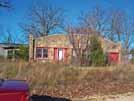
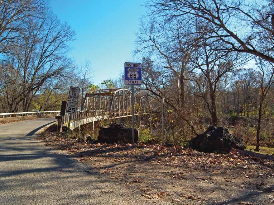
2 Pulaski County A dynamic topographic composition effortlessly reveals Pulaski County along the dense tunnel of vegetation lining Missouri Route 66. Keystone establishments and subliminal experiences retain the same symbolic identity they have always had on the Route. Pulaski County occurs mid way through the state on Route 66. Pulaski County is home to the Gasconade and Big Piney Rivers, Mark Twain National Forest, lakes, springs, recreation areas, Fort Leonard Wood army base as well as 33.4 miles of Missouri Route 66 State Scenic Byway. Public Involvement An important part of the information gathering process for the Corridor Management Plan (CMP) was collecting public input through a public meeting process. Meetings were held in each of the ten counties that the Route 66 travels through in the State of Missouri in an effort to communicate about the CMP to stakeholders. These stakeholders were comprised of community leaders, business owners, residents and travelers of the Road. The public meetings allowed vital input to be collected with regard to the significance that Route 66 has for the state, local communities and individuals. Additionally, opportunities for the preservation, protection and promotion of the resources associated with Route 66 and the value that they provide to the economy were identified through answers to a five question survey administered to attendees. A summary of results from the five question survey administered in the Pulaski County public meeting indicates that 88% of respondents believe that it is important to preserve the Route 66 corridor. 100% of attendees valued historical intrinsic resources highest, followed by scenic and then recreational. Pulaski County meeting attendees believe that they will benefit the most from protecting, promoting and preserving Route 66 by preserving the past, followed by community growth, increased tourism opportunities, personal pride, and increased financial opportunities respectively. 88% of meeting attendees said that they would explore funding opportunities for the protection and preservation of Route 66. Intrinsic Resources Intrinsic resources for Missouri Historic Route 66 represent the characteristics of national significance for the Route as it travels through the state, county by county. The characteristics contain one-of-a-kind features that do not exist anywhere else. Intrinsic qualities are broken into six categories: archaeological, cultural, historic, natural, recreational, and scenic features. These qualities are considered to be representative, unique, irreplaceable, or distinctly characteristic of a place, view, site or building. Byway stakeholders seek to maintain, protect, enhance, interpret, and present the intrinsic resources to byway users for their education and enjoyment. The major character-defining features of Route 66 in Pulaski County include the Hookers cut, Devil s Elbow bridge, the natural beauty, the historical buildings, and the Stagecoach stop as seen from Route 66.
 unit.")
3 Mapping The Missouri Historic Route 66 corridor maps included here show the main driving Route, the Primary Route, and the Alternate Routes. The individual road segments that comprise Missouri Route 66 were verified and precisely located through realtime, kinematic survey using a Global Positioning System (GPS) unit. For some map series, the segments of the Primary and Alternate Routes are color-coded by year to reflect changes in Route 66 through time. Included on the maps are points of interest along the Corridor that have historical and tourism significance. These points were precisely located through collection by a GPS survey. Since the focus of this document is corridor management, only those points of interest that fall within the primary, secondary, or complimentary corridors, as defined by the CMP, were included in the GIS database and map sets. Geospatial data layers that make up the Route 66 geodatabase include: Missouri Route 66, Missouri highways, county roads, points of interest, National Register of Historic Places sites and districts, Department of Natural Resources public lands, parks, rivers, airports, post offices, cemeteries, churches, bridges, cities and towns, and county boundaries. Economic Development Scenic Byway Routes like Missouri Route 66 have value not only for aesthetics and preservation, but also as a way to promote desirable forms of tourism and increase income in regions. Foreign and domestic tourists alike are interested in visiting the various points of interest, and the natural wonders of the physical and cultural environment offered along the Missouri Route 66 corridor. Economic development opportunities in the Pulaski County Route 66 Corridor will be greatly based on corridor travel experience, but include land uses and infill opportunities in the various communities. It should be noted that each municipality within Pulaski County should evaluate local economic development needs and opportunities utilizing some of the tools suggested in the Toolbox of this document. The principal benefit of the Corridor Management Plan project would be to encourage access to future commercial sites, particularly those associated with facilities which would expand the opportunities for goods and services or experience for the travelers along the Route.


4 Toolbox for Pulaski County The toolbox section of the Corridor Management Plan was developed to provide solutions for the Route 66 communities and counties for the implementation of strategies and studies, programs, planning and development design, and funding that will preserve, protect and promote the Missouri Route 66 Corridor. Each section in the toolbox serves as a practical guide for community leaders as they plan. It is intended to connect people with the resources and information they need to strengthen the capacity of their communities. Because viable communities rely on having a diverse economic base, many of the tools focus around economic development for the Missouri Route 66 corridor. The tools described in the toolbox are accepted standards of practice that have been utilized by numerous communities all across the state and the nation. These tools are all encompassing, and are intended to help communities grow, attract new businesses, and maintain or create a diverse economy that it is resilient when changes occur in the national and international economies. The tools also recognize that to compete in the world economy, communities must work together as a region rather than in isolation; that is, it takes a region to supply the ingredients a successful community needs; the workforce, the housing, the training and education, the transportation network, and the technology. Because Missouri Route 66 is a linear community, it is imperative that the counties and cities work together when possible to protect, promote and preserve the corridor, especially with regard to commerce. The bulleted list that follows contains the recommended tools from the toolbox of the Missouri Route 66 Corridor Management Plan for Pulaski County. The County should refer to the toolbox for the full explanation of the suggested concepts as well as the compilation of information available to communities for their consideration when evaluating ways to promote desirable change, growth and economic development. Adaptive re-use Protection of historic resources and low impact design Ordinance development Walkable communities and complete streets Cottage business and small business development Incentives for development Basic services Recreational opportunities Environmental protection and conservation Scenic viewshed protection
5 QP 17 CROCKER BURLINGTON NOR THERN AND SANTA FE CAMDEN BURLINGTON N O RTHERN AND SANTA FE RAILWAY QR 133 QP 28 R AILWAY UNI T ED STATES GOVERNMENT RAILROAD RICHLAND BURLINGTO N N O RTHERN AND SANTA FE RAILWAY QR 133 PULASKI QP 7 QP WAYNESVILLE Map 03 ST. ROBERT Map 04 Map 02 Map 01 MAPBOOK PAGES Map Map 07 Map 06 FORT LEONARD WOOD 1 inch = 2 miles Miles LACLEDE PHELPS
 Z CONCRETE DECK ARCH BRIDGE (L35-1942) B IG PINEY RIVER DIVIDED HIGHWAY (TYPICAL SECTION) STATE HWY Z")

6 TAPESTRY LN GASCONADE HILLS SERVATION AREA GASCONADE RIVER See Map 09 of Phelps County HUSKEY DR STATE ROUTE Z INTERSTATE 44 POWELLVILLE OUTER RD Map 01 QP 28 STATE HWY 28 ") Z CONCRETE DECK ARCH BRIDGE (L ) B IG PINEY RIVER DIVIDED HIGHWAY (TYPICAL SECTION) STATE HWY Z TEADROP RD TEADROP RD ELBOW INN AND BBQ HOOKER CUT AND 4 LANE SECTION OF ROUTE 66 D R TELLER STEEL THRU TRUSS BRIDGE AT DEVIL'S ELBOW SHELDON'S MARKET TROPHY LN 44 KL 66 TROUT RD HUBBARD LN RD TELOS ST. ROBERT TEACHER R D SCENIC OVERLOOK Map 01 BIG PINEY RIVER USG RR TABLE RNACLE LN
7 Map 02 QP 28 STATE HWY 28 TEACHER D R TEADROP RD ") Y TAPESTRY LN LOOP DIVIDED HIGHWAY 44 SPUR V ICKIE ") Z LYNN RD HARLAN LN GEORGE REED ROADSIDE PARK SAINT ROBERT OUTER RD ST. ROBERT HARDY LN KL 66 FT. LEONARD WOOD TOWERSITE I - 44 TE XAS RD TA BOR LN SAINT ROBERT OUTER RD STATE HWY Z TRI PLE LN LN TRUMPET TULSARD 44 USG RR BIG PINEY RIVER Map 02
8 ROUBIDOUX EEK CONSERVATION AREA S TATE HWY 17 Map 03 ROUBIDO UX CREEK ROUBIDOUX CREEK CONSERVATION AREA PULAKSI CO. COURTHOUSE & HIST. SOCIETY MUSEUM CONCRETE ARCH BRIDGE QP 17 ") Y FORMERLY BELL HOTEL RESORT MALLOW'S MARKET VICTORY PUB LYNN ST HILLSIDE DR RIGSBY STANDARD OIL STATION OLD STAGECOACH STOP MUSEUM ROCK FROG OUSLEY RD KL 66 STATE HWY F WAYNESVILLE CHICAGO AVE ") F ZEIGENBIEN RD KING ST GOOD HOPE DR PEGGY AVE LOOP 44 ST. ROBERT COURTNEY CT LOOP 44 SPUR STATE HWY Z ") Z BOHANNON CAFE AND GARAGE 44 DEVILLE MOTOR INN RANCH MOTEL DIVIDED HIGHWAY VI CKIE LYNN R D GEORGE REED ROADSIDE PARK ROUBIDOUX C REE K Map 03
9 CONCRETE ARCH BRIDGE FORMERLY BELL HOTEL RESORT PULAKSI CO. COURTHOUSE & HIST. SOCIETY MUSEUM ROUBIDOUX CREEK CONSERVATION AREA QP 17 OLD STAGECOACH STOP MUSEUM Map 04 LOOP 44 ROCKY MOUNT LN ") T Map 04 RASP U ROYALOAK LN TIN DR RU BY RD S BERRYDALE DR RUD OLPH RD RISKY RD SPRUCE RD ROCKY HILLRD ABLERD DOGWOOD CIR STATE HWY T KL 66 SUNSET DR WAYNESVILLE STATE HWY 17 BALES ST STATE HWY H SUMMIT AVE H U LL DR 44 FLEETWOOD DR HOME AVE BROADWAY ") HBLVD MORGAN ST SHORT ST BROADWAY ST PIKE ST ELM ST ANDERSON ST MALLOW'S MARKET BOHANNON CAFE AND GARAGE VICTORY PUB LYNN ST RIGSBY STANDARD OIL STATION HILLSIDE DR ROUBIDOUX CREEK ROCK FROG ST. ROBERT FORT LEONARD WOOD
10 SILVER LN S ROCKY HILLRD ABLERD WAYNESVILLE Map 05 DOGWOOD CIR BERRYDALE DR RASPU TIN DR RUD OLPH RD RU BY RD ROYALOAK LN 17 RISKY RD WITMOR FARMS RESTAURANT 44 KL 66 SAMANTHA LN SPRUCE RD ROCKY MOUNT LN QP 17 DR GRI GIE SPRUCE RD HWY STATE SWEET LN ") AA STATE HWY P ") P SPARROW LN SHRINE RD STATE HWY 17 STATE SAGE RD Map 05 HWY NN SEAL RD ") NN
11 SAMANTHA LN 44 QP 7 SWEET LN Map 06 SAGE RD SHRINE RD SYRACUSE LN SHERWOOD LN SHELTER DR STATE HWY AA STATE HWY AA STATE HWYP STATE HWY 17 SEAL RD SPARROW LN ") AA ") NN SAPPHIRE DR KL 66 ") P QP 17 STATE HWY NN ") AB STATE HWY AB STONE RD Map 06 STATE HWY 17
12 STAR LN SMOKY RD UTICA DR QR See Map 01 of Laclede County Map 07 HOLIDAY HILLS RD HEARTWOOD RD GASCOZARK CAFE SPRING RD GASCOZARK TRADING POST SHORTY DR ") AB SNIPE RD KL 66 STATE HWY AB GASCONADE RIVER SOUTH BEND RD SKID MORE DR SPRING VALLEY COURT Map 07 ") K


13 Jasper Lawrence Greene Webster Laclede Pulaski Phelps Crawford Franklin St. Louis Gascozark Cafe My father, as a small boy, lived near the Big Piney River and en told us stories of Hookers Cut and the workers who carved it out; it was the deepest cut through rock of any road in the country at the time. Missouri Route 66 road profile as it crosses Pulaski County We love to travel Route 66. We have taken our grandson, twelve years old, with us many times so that he can learn and tell his friends about Route 66. Unknown Debbie & Paul Pulaski County Great River Associates 2826 S. Ingram Mill Road Springfield, MO Pulaski County Great River Associates 2826 S. Ingram Mill Road Springfield, MO The City of Waynesville has several historic buildings located along Route 66. The original Waynesville courthouse is one of them. Old Stagecoach Stop Museum Unknown George Reed Roadside Park Pulaski County Great River Associates 2826 S. Ingram Mill Road Springfield, MO Hookers Cut
Public Involvement Intrinsic Resources
 Phelps County Phelps County Natural beauty abounds in Phelps County. There are endless views of shifting natural compositions. Fauna and flora exist effortlessly in the rolling landscape that includes
Of the Virginia Coal Heritage Trail
 CHAPTER III: ROUTE, MAPS & ROAD DESCRIPTIONS On the Virginia Coal Heritage Trail This Chapter addresses the #1 FHWA requirement for a CMP by providing maps identifying the corridor boundaries, location
Northern Rockies District Value of Tourism Research Project December 2007
 Northern Rockies District Value of Tourism Research Project December 2007 Project Partners: Northern Rockies Regional District, Tourism British Columbia, Northern Rockies Alaska Highway Tourism Association,
The Vision for the San Juan Islands Scenic Byway
 The Vision for the San Juan Islands Scenic Byway 2 Judd Cove, Orcas Island, Courtesy of Kurt Thorson (kurtthorson.com) and San Juan County Land Bank Vision for the San Juan Islands Scenic Byway The San
The Missouri Department of Transportation is proposing to amend the state's five-year Statewide Transportation Improvement Program (STIP).
.") The Missouri Department of Transportation is proposing to amend the state's five-year Statewide Transportation Improvement Program (STIP). A 7-day public comment period regarding the amendment begins January
The Missouri Department of Transportation is proposing to amend the state's five-year Statewide Transportation Improvement Program (STIP). A 7-day public comment period regarding the amendment begins January
MISSOURI BYWAYS PROGRAM GUIDE 2017
 MISSOURI BYWAYS PROGRAM GUIDE 2017 MISSOURI DEPARTMENT OF TRANSPORTATION Our mission is to provide a world-class transportation experience that delights our customers and promotes a prosperous Missouri.
Historic Driving Tours
 Historic Driving Tours DISCOVER THE HISTORIC ROADS AND SITES OF MISSOURI S Pulaski County USA ROUTE 66 FRISCO RAILROAD HISTORIC FORT LEONARD WOOD Scan to load our Audio Tour Scan to load our PulaskiCountyUSA
Historic Driving Tours
 Historic Driving Tours DISCOVER THE HISTORIC ROADS AND SITES OF MISSOURI S Pulaski County USA ROUTE 66 FRISCO RAILROAD HISTORIC FORT LEONARD WOOD Scan to load our Audio Tour Scan to load our PulaskiCountyUSA
Wright City Business Park
 Wright City Business Park 51.69 Acres SITE Wright City Business Park is a 51.69 acre site ideal for large distribution or manufacturing uses. Located approximately ¼ mile west of I-70 exit 199, Wright
April 10, Mark Stiles San Juan Public Lands Center Manager 15 Burnett Court Durango, CO Dear Mark,
 Mark Stiles San Juan Public Lands Center Manager 15 Burnett Court Durango, CO 81301 Dear Mark, We are pleased to offer the following comments on the draft San Juan Public Lands Center management plans
Committee. Presentation Outline
 CW-33-15 11/9/2015 Community and Corporate Services Committee November 10, 2015 1 Presentation Outline Background Vision and Objectives Study Process and Timeline Public and Stakeholder Engagement Organization
Continental Divide National Scenic Trail Legislative History and Planning Guidance
 Continental Divide National Scenic Trail Legislative History and Planning Guidance Legislation, Policy, and Direction Regarding National Scenic Trails The National Trails System Act, P.L. 90-543, was passed
AGENDA ITEM 5 D WAKULLA ENVIRONMENTAL INSTITUTE (WEI) TRAIL FEASIBILITY STUDY
 TRAIL FEASIBILITY STUDY") March 19, 2018 AGENDA ITEM 5 D WAKULLA ENVIRONMENTAL INSTITUTE (WEI) TRAIL FEASIBILITY STUDY TYPE OF ITEM: Action STATEMENT OF ISSUE The Wakulla Environmental Institute (WEI) Trail is one of several trails
March 19, 2018 AGENDA ITEM 5 D WAKULLA ENVIRONMENTAL INSTITUTE (WEI) TRAIL FEASIBILITY STUDY TYPE OF ITEM: Action STATEMENT OF ISSUE The Wakulla Environmental Institute (WEI) Trail is one of several trails
26 Utah s Patchwork Parkway SCENIC BYWAY CORRIDOR MANAGEMENT PLAN (SR 143)
") Natural Natural Quality applies to those features in the visual environment that are in a relatively undisturbed state. These features predate the arrival of human populations and may include geological
Natural Natural Quality applies to those features in the visual environment that are in a relatively undisturbed state. These features predate the arrival of human populations and may include geological
Historic Auto Tours ROUTE 66 FRISCO RAILROAD FORT LEONARD WOOD. DISCOVER THE HISTORIC ROADS AND SITES OF MISSOURI S Pulaski County USA
 Historic Auto Tours DISCOVER THE HISTORIC ROADS AND SITES OF MISSOURI S Pulaski County USA ROUTE 66 FRISCO RAILROAD FORT LEONARD WOOD Scan to load our Audio Tour Scan to load our PulaskiCountyUSA website
ECONOMIC PROFILE PARK CITY & SUMMIT COUNTY, UTAH
 ECONOMIC PROFILE PARK CITY & SUMMIT COUNTY, UTAH Prepared by the Park City Chamber of Commerce & Visitors Bureau PO Box 1630, Park City, UT 84060 1.800.453.1360 Economic Profile Packet Sections 1. Introduction
After School Program Bus Stops Route: 1A p.m.
 Route: A p.m. 0 0 0 School at : pm Depart from Indiana @ Rolla Eagle Point Indiana @ Elwood Indiana Indiana @ Depuy Indiana Diamond @ Epps Partridge Elementary Turner @ Barkley (st) Turner @ Parrish (st)
Kelly Motorized Trails Project Proposed Action
 Kelly Motorized Trails Project Proposed Action November 28, 2011 The Flagstaff Ranger District of the Coconino National Forest is seeking public input on the proposed Kelly Motorized Trails Project (formerly
County of Peterborough Active Transportation Master Plan
 The TMP developed a conceptual AT/cycling network for Peterborough County that identified both on-road and off-road (trail) AT facilities. This was a coarse network based on the existing trails and off-road
SIGNATURE ELEMENTS BICYCLE RACKS & FENCING NSSD HWY. 61 CAIRN & TRAIL SIGNS INTERPRETIVE KIOSK
 SIGNATURE ELEMENTS BICYCLE RACKS & FENCING NSSD HWY. 61 CAIRN & TRAIL SIGNS INTERPRETIVE KIOSK 77 SIGNATURE ELEMENTS BICYCLE RACKS & FENCING: A kiosk, signs, fencing, and bike racks were designed as a
CHAPTER FIVE PROSPECTS FOR FUTURE ECONOMIC DEVELOPMENT
 CHAPTER FIVE PROSPECTS FOR FUTURE ECONOMIC DEVELOPMENT 5.1 GENERAL The recommended type and location of future land uses in Alpine should, in part, consider potential opportunities for future economic
3.0 LEARNING FROM CHATHAM-KENT S CITIZENS
 3.0 LEARNING FROM CHATHAM-KENT S CITIZENS An important aspect in developing the Chatham-Kent Trails Master Plan was to obtain input from stakeholders and the general public. Throughout the course of the
This section of the Plan provides a general overview of the Smoky Mountain Region. It consists of the following four subsections:
 SECTION 3 COMMUNITY PROFILE This section of the Plan provides a general overview of the Smoky Mountain Region. It consists of the following four subsections: 3.1 Geography and the Environment 3.2 Population
SUMMER QUARTERLY MEETING JULY 21, Tri-State Trails is made possible by the generous support of Interact for Health.
 SUMMER QUARTERLY MEETING JULY 21, 2017 Tri-State Trails is made possible by the generous support of Interact for Health. AGENDA Welcome, introductions, and updates around the room Tri-State Trails Announcements
RESEARCH AND PLANNING FORT STEELE HERITAGE TOWN VISITOR STUDY 2007 RESULTS. May 2008
 RESEARCH AND PLANNING FORT STEELE HERITAGE TOWN VISITOR STUDY 2007 RESULTS May 2008 Research and Planning Tourism British Columbia 300-1803 Douglas St. Box 9830 Stn. Prov. Gov t. Victoria, BC V8W 9W5 Web:
The Future of the Road to Revolutions. A Battle Road Scenic Byway Public Forum November 9, 2010
 The Future of the Road to Revolutions A Battle Road Scenic Byway Public Forum November 9, 2010 Who is the Battle Road Scenic Byway? Four Towns: Arlington, Lexington, Lincoln, Concord Minute Man National
PARKLAND COUNTY TOURISM ACTION PLAN
 PARKLAND COUNTY TOURISM ACTION PLAN 2018-2020 CONTENTS Introduction............................................... 05 Organizational Alignment.................................. 07 Action Plan Development..................................
MUNICIPALITY OF ANCHORAGE
 MUNICIPALITY OF ANCHORAGE ANCHORAGE PARKS & RECREATION Memorandum PRC 08-56 DATE: 5 August 2008 TO: FROM: SUBJECT: Parks & Recreation Commission Holly Spoth-Torres, Park Planner PRC 08-56 Far North Bicentennial
Chapter 1: Introduction
 Chapter 1: Purpose of the Comprehensive Plan The purpose of the Comprehensive Plan of the City of Rockaway Beach is to provide a policy guide for the growth and future development of the City. Section
Review of 2009 Camping Season
 Review of 2009 Camping Season Tourism and Parks Department of Industry, Tourism and Investment Government of the Northwest Territories 3/31/2010 1.0 Introduction The Department of Industry, Tourism and
Non-motorized Trail Plan & Proposal. August 8, 2014
 Town of Star Valley Ranch, Wyoming and the Star Valley Ranch Association in partnership with the USDA Forest Service, Bridger-Teton National Forest, Greys River Ranger District Non-motorized Trail Plan
TERRITORIES: BACKGROUND REPORT. Submitted to the NWT Recreation and Parks Association by Avens Associates Ltd.
 TRAILS in the NORTHWEST TERRITORIES: BACKGROUND REPORT Submitted to the NWT Recreation and Parks Association by Avens Associates Ltd. i TRAILS in the NORTHWEST TERRITORIES: BACKGROUND REPORT Report to:
Evaluating Lodging Opportunities
 Evaluating Lodging Opportunities This section explores market opportunities for new lodging accommodations in the downtown area. It will help you understand travel and visitation trends, existing competition,
OVERVIEW Four year annual average to the year ending September 2014
 LGA PROFILE - Mid-Western Regional OVERVIEW Key Measures Mid-Western Regional NSW Total Visitors (overnight and domestic daytrip) (000's) 524 80,316 Total Overnight Visitors (000's) 298 28,105 Total Nights
1.2 Corridor History and Current Characteristics
 SECTION 1 Description and Background of Study Area 1.1 Introduction This preliminary engineering report was prepared for the Alaska Department of Transportation and Public Facilities (ADOT&PF). It is part
OVERVIEW Four year annual average to the year ending September 2014
 Dec-08 Mar-09 Jun-09 Sep-09 Dec-09 Mar-10 Jun-10 Sep-10 Dec-10 Mar-11 Jun-11 Sep-11 Dec-11 Mar-12 Jun-12 Sep-12 Dec-12 Mar-13 Jun-13 Sep-13 Dec-13 Mar-14 Jun-14 Sep-14 Visitors (000's) LGA PROFILE - Oberon
OVERVIEW Four year annual average to the year ending September 2014
 Dec-08 Mar-09 Jun-09 Sep-09 Dec-09 Mar-10 Jun-10 Sep-10 Dec-10 Mar-11 Jun-11 Sep-11 Dec-11 Mar-12 Jun-12 Sep-12 Dec-12 Mar-13 Jun-13 Sep-13 Dec-13 Mar-14 Jun-14 Sep-14 Visitors (000's) LGA PROFILE - Orange
Mississippi River Parkway Commission of Minnesota
 Mississippi River Parkway Commission of Minnesota Metro Region (Elk River to Hastings) October 27, 2016 2:00 3:30 p.m. Historic Fort Snelling 200 Tower Avenue, St. Paul, MN Metro Region Agenda I. Welcome
Chapter 1: Introduction Draft
 Chapter 1: Draft TABLE OF CONTENTS 1... 4 1.6.1 Stakeholder Engagement Plan... 10 Chapter 1 Page 2 TABLE OF EXHIBITS Exhibit 1.1-1 ABIA Annual Growth Since 1993... 5 Exhibit 1.4-1: ABIA Location Map...
SANBI PLANNING FORUM
 SANBI PLANNING FORUM SPATIAL PLANNING IN PROTECTED AREAS AND THEIR BUFFERS (South Africa) Ms Jayshree Govender, Dr Mike Knight and Mr Russell Smart 22 June 2017 OUTLINE 1) Introduction 2) Protected areas
Interview with Mr. Aaron Mahr, superintendent of the National Park Service s (NPS) National Trails, U.S.A. Route 66
 National Trails, U.S.A. Route 66") Interview with Mr. Aaron Mahr, superintendent of the National Park Service s (NPS) National Trails, U.S.A Route 66 1. Please introduce yourself, your role, your organization and the historic route you
Interview with Mr. Aaron Mahr, superintendent of the National Park Service s (NPS) National Trails, U.S.A Route 66 1. Please introduce yourself, your role, your organization and the historic route you
OREGON TOURISM LISTENING SESSION SUM M ARY
 OREGON TOURISM LISTENING SESSION SUM M ARY June 2018 T O U R I S M L I S T E N I N G S E S S I O N O V E R V I E W Travel Oregon, in partnership with the Central Oregon Visitors Association, hosted an
Project Deliverable 4.1.3d Individual City Report - City of La Verne
 Pomona Valley ITS Project Project Deliverable 4.1.3d Individual City Report - City of La Verne Prepared by: April 19, 2002 099017000.1 Copyright 2002, Kimley-Horn and Associates, Inc TABLE OF CONTENTS
3. Accommodation services
 11 3. Accommodation services When one travels to another city or country, one usually has different needs and demands for the destination one is travelling to. Trying to meet these needs and demands is
National Scenic Byways Program US Department of Transportation
 1 2 National Scenic Byways Program US Department of Transportation Abstract The Cowlitz-Wahkiakum Council of Governments in partnership with Cowlitz, Skamania and Lewis Counties and the U.S. Forest Service,
Staff Report Sign Design
 Staff Report Sign Design July 29, 2014 Planning & Zoning Commission Meeting Report date July 23, 2014 Project type Sign Design Legal description Section 2, Township 5, Range 82 Lots 3&4, S1/2NW1/4, SW1/4
TRAIL DATABASE SCHEMA (8/26/2014)
") Trail Data Model for LINES Source Data Source Agency dataagency Agency or entity that created the dataset where the original line was sourced from. Source Date of Last Data Used to Update sourcedate Publication
Trail Data Model for LINES Source Data Source Agency dataagency Agency or entity that created the dataset where the original line was sourced from. Source Date of Last Data Used to Update sourcedate Publication
Rogue River Access and Management Plan Draft Alternatives
 Rogue River Access and Management Plan Draft Alternatives The Rogue River Access and Management Plan was initiated in December, 2011 and is being led by Jackson County Parks (JCP) and Oregon Department
Classifications, Inventory and Level of Service
 Classifications, Inventory and Level of Service Section 3 Kenmore Park, Recreation and Open Space Plan 1 P a g e Classifications and Inventory Park Classifications Kenmore classifies its parks based upon
MANAGEMENT DIRECTION STATEMENT June, 1999
 Thompson River District MANAGEMENT DIRECTION STATEMENT June, 1999 for Roche Lake Provincial Park Ministry of Environment Lands and Parks BC Parks Division Table of Contents I. Introduction A. Setting
Susitna-Watana Hydroelectric Project (FERC No ) Recreation Resources Study Study Plan Section Study Implementation Report
 Recreation Resources Study Study Plan Section Study Implementation Report") (FERC No. 14241) Recreation Resources Study Study Plan Section 12.5 2014 Study Implementation Report Prepared for Prepared by AECOM November 2015 TABLE OF CONTENTS 1. Introduction... 4 2. Study Objectives...
(FERC No. 14241) Recreation Resources Study Study Plan Section 12.5 2014 Study Implementation Report Prepared for Prepared by AECOM November 2015 TABLE OF CONTENTS 1. Introduction... 4 2. Study Objectives...
Southern Shenandoah Valley Chapter
 Southern Shenandoah Valley Chapter June 7, 2018 Members of the State Water Control Board c/o Office of Regulatory Affairs, Department of Environmental Quality P.O. Box 1105 Richmond, Virginia 23218 citizenboards@deq.virginia.gov
CHAPTER 4 -- THE LAND USE PLAN: DESCRIPTIONS AND POLICIES FOR THIRTEEN PLANNING AREAS
 CHAPTER 4 -- THE LAND USE PLAN: DESCRIPTIONS AND POLICIES FOR THIRTEEN PLANNING AREAS SOUTH COAST CAC PLANNING AREA 4.10 NAVARRO RIVER TO MALLO PASS CREEK PLANNING AREA (Includes Greenwood/Elk) This planning
REVISED PLANNING PROPOSAL Volume syw082 Station Stret, Menangle
 REVISED PLANNING PROPOSAL Volume 2 2013syw082 Station Stret, Menangle Part 4 Mapping Existing Controls in the Wollondilly LEP 2011 affecting the Site Zone / Standard Zone Control The land is zoned RU1
Featuring North America s Leading Travel Destinations. Great American Roads
 Featuring North America s Leading Travel Destinations Great American Roads The Alaska Highway, U.S. 395 in California, Colorado s Million Dollar Highway, The Natchez Trace, Parkersburg-Staunton Turnpike,
Airport Planning Area
 PLANNING AREA POLICIES l AIRPORT Airport Planning Area LOCATION AND CONTEXT The Airport Planning Area ( Airport area ) is a key part of Boise s economy and transportation network; it features a multi-purpose
Overview of the Southern Nevada Convention and Meeting Segment
 Executive Summary Applied Analysis was retained by the Las Vegas Convention and Visitors Authority (the LVCVA ) to review and analyze the economic impacts associated with its various operations and southern
Hazlet. 1. Overview of Hazlet and Its Waterfront. Hazlet Township. 1.1 Geographic Overview
 Hazlet 1. Overview of Hazlet and Its Waterfront 1.1 Geographic Overview Hazlet Township is located in Monmouth County. The Township has a land area of 5.6 square miles. Situated in the Bayshore region
Gold Coast. Rapid Transit. Chapter twelve Social impact. Chapter content
 Gold Coast Rapid Transit Chapter twelve Social impact Chapter content Social impact assessment process...235 Existing community profile...237 Consultation...238 Social impacts and mitigation strategies...239
OVERVIEW Four year annual average to the year ending September 2014
 Dec-08 Mar-09 Jun-09 Sep-09 Dec-09 Mar-10 Jun-10 Sep-10 Dec-10 Mar-11 Jun-11 Sep-11 Dec-11 Mar-12 Jun-12 Sep-12 Dec-12 Mar-13 Jun-13 Sep-13 Dec-13 Mar-14 Jun-14 Sep-14 Visitors (000's) LGA PROFILE - Snowy
CHAPTER 4 -- THE LAND USE PLAN: DESCRIPTIONS AND POLICIES FOR THIRTEEN PLANNING AREAS
 CHAPTER 4 -- THE LAND USE PLAN: DESCRIPTIONS AND POLICIES FOR THIRTEEN PLANNING AREAS NORTH CENTRAL CAC AREA LITTLE VALLEY ROAD TO JUG HANDLE CREEK PLANNING AREA This planning area includes Cleone, Noyo,
Economic Development and Tourism
 SECTION 4 SECTION 4 Economic Development and Tourism 4. Economic Development and Tourism Tourism plays a very important role in Niagara s economy, providing employment and generating business for support
Blue Mountains Visitors. International overnight, domestic overnight and domestic daytrip visitors. Sep-11. Jun-11. Sep-10. Dec-10. Dec-11.
 Dec-08 Mar-09 Jun-09 Sep-09 Dec-09 Mar-10 Jun-10 Sep-10 Dec-10 Mar-11 Jun-11 Sep-11 Dec-11 Mar-12 Jun-12 Sep-12 Dec-12 Mar-13 Jun-13 Sep-13 Dec-13 Mar-14 Jun-14 Sep-14 Visitors (000's) OVERVIEW LGA PROFILE
Town of Limon Comprehensive Plan CHAPTER 6 TOURISM AND THE VISITOR ECONOMY
 CHAPTER 6 TOURISM AND THE VISITOR ECONOMY 65 VISION Limon s location at the intersection of Interstate 70, and Highways 24, 40, 71, and 287, provides steady traveler traffic with an estimated 80,000 overnight
Chapter 1: Introduction
 Chapter 1: TABLE OF CONTENTS 1... 4 1.1 Master Plan Study Content... 4 1.2 Purpose and Scope of Master Plan Study... 4 1.3 Airport History and Role... 6 1.4 Airport Location and Service Area... 6 1.5 ABIA
SOUTH INTERCHANGE AREA
 Santaquin City General Plan 1 Location and Characteristics The South Interchange Area of Santaquin is located west of Interstate 15 and south of 500 South (Figure 1). It includes properties already annexed
WORKSHEET 1 Wilderness Qualities or Attributes Evaluating the Effects of Project Activities on Wilderness Attributes
 WORKSHEET 1 Wilderness Qualities or Attributes Evaluating the Effects of Project Activities on Wilderness Attributes Date: 3/7/2017 Roadless Area: Ruby South Description of Project Activity or Impact to
United States Department of the Interior National Park Service. Boundary Expansion Listed in National Register January 11, 2017
 NPS Form 10900-a (Rev. 8/2002) OMB No. 10240018 United States Department of the Interior National Park Service Boundary Expansion Listed in National Register January 11, 2017 National Register of Historic
OVERVIEW Four year annual average to the year ending September 2014
 LGA PROFILE - OVERVIEW Total Visitors (overnight and domestic daytrip) (000's) 1,453 80,316 Total Overnight Visitors (000's) 749 28,105 Total Nights (000's) 2,728 154,563 Total Spend (overnight and domestic
OVERVIEW Four year annual average to the year ending September 2014
 Dec-08 Mar-09 Jun-09 Sep-09 Dec-09 Mar-10 Jun-10 Sep-10 Dec-10 Mar-11 Jun-11 Sep-11 Dec-11 Mar-12 Jun-12 Sep-12 Dec-12 Mar-13 Jun-13 Sep-13 Dec-13 Mar-14 Jun-14 Sep-14 Visitors (000's) LGA PROFILE - Newcastle
X. COMMUNITY ECONOMY
 X. COMMUNITY ECONOMY Issue Statement Economic considerations play an integral role in the development of every community. Park City s challenge is to remain competitive in the changing recreational market,
OVERVIEW Four year annual average to the year ending September 2014
 Dec-08 Mar-09 Jun-09 Sep-09 Dec-09 Mar-10 Jun-10 Sep-10 Dec-10 Mar-11 Jun-11 Sep-11 Dec-11 Mar-12 Jun-12 Sep-12 Dec-12 Mar-13 Jun-13 Sep-13 Dec-13 Mar-14 Jun-14 Sep-14 Visitors (000's) LGA PROFILE - Forbes
OVERVIEW Four year annual average to the year ending September 2014
 LGA PROFILE - Tweed OVERVIEW Total Visitors (overnight and domestic daytrip) (000's) 1,444 80,316 Total Overnight Visitors (000's) 534 28,105 Total Nights (000's) 2,054 154,563 Total Spend (overnight and
OVERVIEW Four year annual average to the year ending September 2014
 LGA PROFILE - Forbes OVERVIEW Total Visitors (overnight and domestic daytrip) (000's) 155 80,316 Total Overnight Visitors (000's) 69 28,105 Total Nights (000's) 191 154,563 Total Spend (overnight and domestic
DATE: 23 March, 2011 TO: Communities FROM: BlazeSports America. RE: Accessible Trails Checklist 1
 M E M O R A N D U M DATE: 23 March, 2011 TO: Communities FROM: BlazeSports America RE: Accessible Trails Checklist 1 The purpose of the Accessible Trails Checklist (below) is to help the community review
Saturday, June 17 to Sunday June 25, Stampede to Cody
 Saturday, June 17 to Sunday June 25, 2017 Stampede to Cody Wind River Canyon Wind River Canyon is a scenic Wyoming canyon carved out by the Wind River. It is located between the cities of Shoshoni and
ROYAL GORGE PARK and RECREATION AREA. A Feat of Natural and Man-Made Engineering
 ROYAL GORGE PARK and RECREATION AREA A Feat of Natural and Man-Made Engineering As Growth Resumed in the 1870 s Town Leaders Began to Envision a Tourist Industry. The Arkansas River Canyon was advertised
Vacant Restaurant Redevelopment Site
 Vacant Restaurant Redevelopment Site Call For Offers Deadline November 15 th Representative Photo 8466 Gratiot Avenue Saginaw, Michigan, 48609 Offering Price: $300,000 Rolling Bid Process That Will Conclude
Welcome to the future of Terwillegar Park a Unique Natural Park
 Welcome to the future of Terwillegar Park a Unique Natural Park 1 Introduction The Terwillegar Park Concept Plan study will develop an overall concept plan, management objectives and development guidelines
Pillar Park. Management Plan
 Pillar Park Management Plan January 2014 Pillar Park Management Plan Approved by: Jeff Leahy Regional Director Thompson Cariboo Region BC Parks January 9, 2014 Date Brian Bawtinheimer Executive Director
OVERVIEW Four year annual average to the year ending September 2014
 Dec-08 Mar-09 Jun-09 Sep-09 Dec-09 Mar-10 Jun-10 Sep-10 Dec-10 Mar-11 Jun-11 Sep-11 Dec-11 Mar-12 Jun-12 Sep-12 Dec-12 Mar-13 Jun-13 Sep-13 Dec-13 Mar-14 Jun-14 Sep-14 Visitors (000's) LGA PROFILE - Port
110, 114 & 190 BICENTENNIAL WAY. HADEN ONGARO Executive Vice President RON REINKING Managing Director FOUNTAINGROVE PKWY LAKE PARK DR BICENTENNIAL WAY
 FOR SALE: 3 RETAIL PADS - HOME DEPOT ANCHOR 190 Parcel 3 APN: 173-060-004 ±1.87 ACRES $1,500,000 114 Parcel 4 APN: 173-060-003 ±1.11 ACRES $ 750,000 110 Parcel 5 APN: 173-060-010 ±0.91 ACRES $ 750,000
Cooma-Monaro Visitors. International overnight, domestic overnight and domestic daytrip visitors. Sep-11. Sep-10. Jun-11. Dec-11. Dec-10.
 OVERVIEW LGA PROFILE - Cooma-Monaro Key Measures Cooma- Monaro NSW Total Visitors (overnight and domestic daytrip) (000's) 301 80,316 Total Overnight Visitors (000's) 119 28,105 Total Nights (000's) 346
Project Planning, Compliance, and Funding
 Project Planning, Compliance, and Funding The plans above offer high level guidance to ensure that the A.T. is managed effectively as a whole unit in a decentralized management structure. Cooperative management
3. Proposed Midwest Regional Rail System
 3. Proposed Midwest Regional Rail System 3.1 Introduction The proposed Midwest Regional Rail System (MWRRS) will operate in nine states, encompass approximately 3,000 route miles and operate on eight corridors.
Washington County Ostrum Trail North/Broadway Street (CSAH 4)
") Washington County Ostrum Trail North/Broadway Street (CSAH 4) Open House Agenda Introductions Project Presentation Group Questions & Answers Breakout Sessions by Zones Discuss project details, issues,
Washington County Ostrum Trail North/Broadway Street (CSAH 4) Open House Agenda Introductions Project Presentation Group Questions & Answers Breakout Sessions by Zones Discuss project details, issues,
Fred Milch Project Review Manager East Central Florida Regional Planning Council
 RESHAPING THE ROLE OF PARKS, RECREATIONAL AREAS, AND GREEN SPACE TO ENHANCE LIVABILITY Fred Milch Project Review Manager East Central Florida Regional Planning Council St. Johns River to Sea Loop Webinar
Classification of products and productive activities for tourism
 Classification of products and productive activities for tourism Developing National Systems of Tourism Statistics: Challenges and Good Practices Regional Workshop for the CIS countries, 29 June 2 July
Prairie Spirit Trail
 Prairie Spirit Trail January 2011 Trail Segments as: Road Map 5 miles per inch Aerial Photo 1 mile per inch Maps sequenced in direction of increasing milepost numbers Click in center of white boxes on
Beaver Creek Provincial Park. Management Plan
 Beaver Creek Provincial Park Management Plan 2 Beaver Creek Provincial Park Table of Contents 1. Introduction... 3 2. Park History... 3 3. Park Attributes... 4 3.1 Natural... 4 3.2 Recreational... 4 4.
NAPA VALLEY VISITOR INDUSTRY 2012 Economic Impact Report
 Join Visit Napa Valley NAPA VALLEY VISITOR INDUSTRY 2012 Economic Impact Report Research prepared for Visit Napa Valley by Destination Analysts, Inc. Table of Contents SECTION 1 Introduction 2 SECTION
REQUEST FOR PROPOSALS #1 FOR LEASE OF REAL PROPERTY KNOWN AS CANAL STREET MILL 10 CANAL STREET, VILLAGE OF PHILMONT, NEW YORK
 REQUEST FOR PROPOSALS CANAL STREET MILL VILLAGE OF PHILMONT, NY RFP RELEASE DATE: MARCH 11, 2019 SITE TOUR DATE: MARCH 22, 2019 DEADLINE TO MARCH 25, 2019 SUBMIT QUESTIONS: By 12 noon EST DEADLINE TO APRIL
CRANE LAKE TRAILS NETWORK AND SPACES
 CRANE LAKE TRAILS NETWORK AND SPACES AREA TRAILS COMMUNITY TRAILS GOLD COAST TRAIL LAKE PARK OPTION ONE LAKE PARK OPTION TWO OVERFLOW TRAILHEAD PARKING THE GATE AREA TRAILS Trails are a major resource
After School Program Bus Stops Route: 1A p.m.
 Route: A p.m. 0 0 (Wed- : pm) Turner @ Peden Pl Turner @ Turner Ct Turner @ Ellis Turner @ Parrish (st) Turner @ Barkley (st) Turn around at the Pool parking lot,continue back torwards Ellis St and turn
Navigating Indiana Road Signage
 Navigating Indiana Road Signage JOE BRUNO Traffic Administration Engineer Indiana Department of Transportation Presentation Overview Background Logo Program (Gas, Food, Lodging, & Camping Services) Attraction
Instructions: Script:
 Before the course, select four of the 11 tool topics to insert into the presentation, including at least one tool from each of the three goal categories. Replace each tool placeholder slide with the slides
CHAPTER 3 PLANNING GOALS
 CHAPTER 3 PLANNING GOALS AND PUBLIC INPUT INTRODUCTION This portion of the Algonac Master Plan is intended to outline a course for action in achieving the community s vision for the future. Throughout
OVERVIEW Four year annual average to the year ending September 2014
 Dec-08 Mar-09 Jun-09 Sep-09 Dec-09 Mar-10 Jun-10 Sep-10 Dec-10 Mar-11 Jun-11 Sep-11 Dec-11 Mar-12 Jun-12 Sep-12 Dec-12 Mar-13 Jun-13 Sep-13 Dec-13 Mar-14 Jun-14 Sep-14 Visitors (000's) LGA PROFILE - Great
Section II. Planning & Public Process Planning for the Baker/Carver Regional Trail began in 2010 as a City of Minnetrista initiative.
 Section II Planning & Public Process Planning for the began in 2010 as a City of initiative. city staff began discussions with the Park District on the possibility of a north/south regional trail connection
AERONAUTICAL SURVEYS & INSTRUMENT FLIGHT PROCEDURES
 AERONAUTICAL SURVEYS & INSTRUMENT FLIGHT PROCEDURES Current as of November 2012 ALASKA AVIATION SYSTEM PLAN UPDATE Prepared for: State of Alaska Department of Transportation & Public Facilities Division