PUNGWE RIVER BASIN. Government of the Republic of Mozambique Government of the Republic of Zimbabwe. A monograph of the
|
|
|
- Amberlynn Francis
- 6 years ago
- Views:
Transcription


1 Government of the Republic of Mozambique Government of the Republic of Zimbabwe A monograph of the PUNGWE RIVER BASIN - LIGHT EDITION A part of the project: DEVELOPMENT OF THE PUNGWE RIVER BASIN JOINT INTEGRATED WATER RESOURCES MANAGEMENT STRATEGY

2 Preamble Water is fundamental for human survival, health and dignity and the prerequisite for human development. However, in many places of the world the freshwater resources are under increasing pressure because of over utilisation and pollution from human activities. The Pungwe River is no exception. Although the current situation is generally good, projections of future water requirements show an increasing competition between different water users. In addition the current problem of informal small-scale mining that periodically creates high suspended sediment in the river has shown that the Pungwe River and its downstream users are vulnerable for manmade activities in the upper reaches. Management of the water resources are therefore essential to overcome current and future problems of supplying water of adequate quantity and quality to all users in the Pungwe River basin. This management must take into account the interests of all parties and sectors, including ecological factors, to enable a sustainable and equitable use of the water at the basin or catchment scale. This is known today as Integrated Water Resources Management, or in short IWRM. IWRM is a participatory planning process, based on sound science, which brings together stakeholders to determine how to meet society s long-term needs for water resources while maintaining essential ecological and economic values. It is an interdisciplinary and collected process that promotes a cross-sectoral coordination in water management. The Pungwe River is shared by the countries Zimbabwe and Mozambique. The Governments of Zimbabwe and Mozambique have recognised the need for sustainable water management of the river and have therefore jointly emerged on the project: Pungwe River Basin Joint Integrated Water Resources Management Strategy (the Pungwe Project in short). The Pungwe Project is a co-operative effort by the two Governments to create a framework for the sustainable and equitable management, development and conservation of the water resources of the Pungwe River basin, with the objective of increasing the derived social and economic benefits for the people living in the basin. A key element in the development of this strategy by the Project lies in building capacity for its implementation and upgrading, to facilitate effective participatory management by both the authorities and stakeholders. The Pungwe Project is financed by the Swedish International Development Co-operation Agency (Sida), through an agreement with Zimbabwe and Mozambique. It is implemented under the auspices of the Department of Water Resources (DWR), in the Ministry of Rural Resources, Water Development and Irrigation (MRRWD&I), Zimbabwe, and the National Directorate of Water (DNA), in the Ministry of Public Works and Housing, Mozambique, on behalf of the two governments. The implementing agencies are the Zimbabwe National Water Authority (ZINWA) through the Save Catchment Manager s Office, and the Regional Water Administration of Central Mozambique (ARA-Centro), respectively. The Pungwe project commenced in February 2002 and is anticipated to be finalised in April A consortium of Consultants, led by SWECO International of Sweden, assists the implementing agencies during the project. One of the basic fundaments of IWRM is the knowledge of the current situation in the river basin. How much water resources are naturally available? What are the socio-economic conditions? How large are the potential for agricultural development in relation to soil suitability and water availability? What are the key environmental assets and how are these affected by future development? The answers to these and many other similar questions are fundamental for a successful implementation of water management. One of the key tasks of the Pungwe Project has therefore been to produce a monograph, describing in detail the Pungwe River basin in relation to water management. The final result of this task is an extensive report series with a main report and twelve annexes, to be used as a tool for the professionals working with water management in the Pungwe River basin. To enable a wider knowledge among the stakeholders of the Pungwe River basin the two Governments have suggested creating a short version of the monograph. Through this shorter version the water authorities of the two countries aim to increase the awareness and understanding about the factors affecting the water resources of the Pungwe River basin and by this promote the process of water management among the stakeholders. We hope that this River Basin Monograph will give the reader an enjoyable and informative experience. November 2006 Julião Alferes Director National Directorate of Water, Mozambique Manuel Fobra Director, ARA-Centro, Mozambique Vavarirai Choga Director Department of Water Resources, Zimbabwe Thomas Murinye Catchment Manager, ZINWA Save, Zimbabwe Rikard Lidén Project Director, SWECO International, Sweden


3 A MONOGRAPH OF THE PUNGWE RIVER BASIN Table of Contents The Biophysical Environment 2 Socio-economic Conditions of the Pungwe River Basin 10 Water Resources of the Pungwe River Basin 14 Water Quality in the Pungwe River Basin 18 Water Use in the Pungwe River Basin 20 Water Resources Management in the Pungwe River Basin 22 Future Water Resources Development 24 Beira Harbour in the Pungwe Estuary
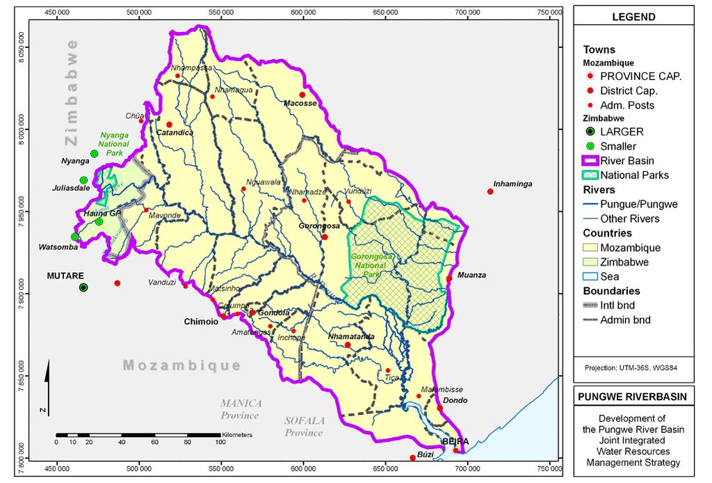
 is in Mozambique. The main Pungwe River has a total length of approximately 400 km. The map on the opposite page shows the basin area.")
4 THE BIOPHYSICAL ENVIRONMENT Physiography and Drainage The Pungwe Basin in Zimbabwe and Mozambique covers a total area of 31,151 km 2, of which 1,461 km 2 (4.7%) lies in Zimbabwe, and 29,690 km 2 (95.3%) is in Mozambique. The main Pungwe River has a total length of approximately 400 km. The map on the opposite page shows the basin area. The Pungwe River originates in the eastern highlands of Zimbabwe, and flows in a general easterly direction through Mozambique into the Indian Ocean. The Pungwe River rises from the western slopes of the Inyangani Mountains from an altitude of 2,500 m above mean sea level (amsl). It flows southwards for about 20 km, where it abruptly changes course at Pungwe Falls, a location renowned for its scenic beauty, and meanders in a general easterly direction through an area known as the Honde Valley. The river then crosses the Mozambican border near Katiyo Tea Estate, approximately 60 km from its headwaters, at an altitude of about 579 m amsl. The principal tributaries of the Pungwe River in Zimbabwe are the Honde on the right bank and the Nyazengu, Chiteme, Nyamhingura, Nyawamba, Nyamukombe, and Rwera rivers on the left bank. In Zimbabwe, the drainage area is a combination of national park area, exotic forest plantations in the upstream reaches, and mixed agriculture in the middle and lower valleys. The Nyamukwarara River, a tributary of the Honde, drains some alluvial gold mining and panning areas in both Zimbabwe and Mozambique, where it collects a large quantity of sediment that remains visible along the river beyond Tete Bridge in Mozambique. 2
5 3
, where it enters the floodplain, and thence into the Pungwe Estuary (intertidal zone).")
6 THE BIOPHYSICAL ENVIRONMENT After crossing Zimbabwe, the Pungwe River flows in a south-easterly direction into Mozambique. It flows through mixed farmlands, traversing along the southern border of the Gorongosa National Park (GNP), where it enters the floodplain, and thence into the Pungwe Estuary (intertidal zone). It then flows into the Indian Ocean at Beira Port. The main tributaries of the Pungwe in Mozambique are the Nhazonia, the Txatora, the Vunduzi and the Urema rivers rising from the north to join the main river on its left bank, and the Honde, the Metuchira and the Muda from the south. The Urema system is fed from the Vanduzi River (locally known as Vunduzi) in the north-west and the Mucambezi River in the north-east. The former originates from the Gorongosa Mountain at an elevation of 1,863 m amsl. The Mucambezi system rises south of the shallow divide separating the Pungwe and Zambezi sub-systems. Both tributaries flow southwards into the seasonal Urema Lake, which exits into Urema River and thence into the main Pungwe stem. The physiography and drainage pattern of the basin is illustrated in the 3-dimensional map below. On the opposite page a figure shows the principal tributaries of the Pungwe River in Mozambique in relation to the GNP and the Gorongosa Mountain. Urema Lake varies considerably in size from a minimum of about 10 km 2 during the dry season to 120 km 2 during periods of high river flow. Around the lake, the terrain is very flat, with the flood plain ecosystem very sensitive to changes in the flow regime. The waters of the lake and downstream Urema River are generally referred to as white waters due to their distinctive yellow-ochre colour and opaqueness that perpetuates downstream below the confluence with the main Pungwe River. The lower basin is just a few metres above sea level and is often subjected to flooding during the rainy season. During low river flows sea water flows back into the river, reaching up to about 80 to 100 km from the mouth. Climate and General Hydrology The major influences on climate in the Pungwe River Basin are the altitude and orography (relief), in combination with proximity to the ocean. It ranges from tropical continental in the west to tropical humid in the coastal areas in the east. From the Mozambican channel the general relief is characterised by lowlying land, which rises rapidly as it approaches the eastern slopes of the Inyangani range. Orographic influences are more pronounced in the western part of the basin, where altitudes increase from 600 m to over 2,500 m amsl, over a relatively short distance. This orographic pattern forces oceanic air, when it prevails, to rise up the eastern slopes, cooling in the process, and if sufficiently moist, resulting in cloud formation and often precipitation. The cloud formation also lowers surface temperature by blocking the sun s rays. The physiography and drainage pattern of the Pungwe River Basin Across the basin, average minimum temperatures range from 22 o C in the coastal areas to 9.9 o C in the higher areas of Inyangani Mountain range, with maxima ranging from 29 o C to 19.8 o C as alti- 4


7 tude increases. In the higher altitudes all year round temperatures are among the lowest in Zimbabwe. These low temperatures have a moderating effect on evapotranspiration in the region, compared to other parts of the country. The effect of orograghy on rainfall is more pronounced in the upper reaches of the basin where there is a rapid increase in altitude, as shown in the 3D model below to the right. Orographic effects on rainfall are also clearly illustrated by the drastic change in specific runoff between gauging stations located on different altitudes. A similar effect is also experienced in the Gorongosa Mountain, in Mozambique, which receives significantly more rainfall compared to the surrounding areas. In general, the main rainfall influences in the Pungwe catchment area are the movements of the Inter-tropical The principal tributaries of the Pungwe River in relation to the GNP and the Gorongosa Mountain Eastern Highlands in Zimbabwe Convergence Zone (ITCZ), and the South East Trades. The influence of the ITCZ normally extends from around November to March. The ITCZ is a complex zone where the following three distinct air currents converge: 1. The South East trades from the Indian Ocean covering Mozambique and Zimbabwe 2. The South West Trades of the Atlantic Ocean approaching Zimbabwe from the North West and commonly referred to as Zaire Air 3. The North East monsoon flowing out of the Asiatic High in the region of the Arabic sea The South East trades are responsible for winter rainfall falling between April and September in the higher areas of the basin. In the Nyanga region, winter rainfall constitutes approximately 12% of annual rainfall in the area. Zimbabwe Mozambique 1490 Rainfall in the upper Pungwe [mm/year] 5
, deep gorges (Pungwe Gorge) and valleys, as well as rapids and falls (Pungwe Falls) in the")
, upland and middle plateau.")
8 THE BIOPHYSICAL ENVIRONMENT Geology and Soils In the western parts, the geology of the Pungwe River Basin is dominated by extensive deeply incised granites with occasional dyke intrusives. This geological characteristic has given rise to the formation of high mountain peaks (Inyangani Mt), deep gorges (Pungwe Gorge) and valleys, as well as rapids and falls (Pungwe Falls) in the vicinity of the dykes. Occasional gneissic rock is observed in the geology of the Honde River drainage area. In the central part of the Basin, in Mozambique, geology is dominated by the basement complex consisting of mountains (Gorongosa Mt), upland and middle plateau. Towards the east geology gives way to mainly sandstones in the Sena Plains and Cheringoma Plateau that are divided by a continuation of the East African Rift Valley system. The western part of the basin consists of red soils of considerable depth in some areas, which become shallower in the mountain areas. Towards the east, Gorongosa Mountain soils below the plateau range from clayey-sandy fluvial dark soils to shallow soils with little agricultural potential. Flora The figure on the opposite page shows the distribution of 16 broad vegetation types of the Pungwe River Basin. The dominant type of vegetation, that occupies approximately 50% of the basin, is the miombo woodland. A total of five different species of miombo woodland occur in the basin, depending on altitude and rainfall. Two important vegetation relics of moist evergreen forests occur on the Gorongosa Mountain, and on the slopes and gullies of the Inyangani Mountain range, along the border between Mozambique and Zimbabwe. These unique ecosystems have been created by micro-climates that occur in the high altitude, high rainfall areas. In the Zimbabwean part of the Pungwe River Basin the massive granite weathers to bare domes Around the Urema Lake and the flood plains, vast areas are flooded during the wet season giving rise to floating pastures and conspicuous flowering water lilies. This lush and verdant growth gives way to a contrasting layer of brown shriveled grass in the dry season. Towards the coast, in the flood plain, mangrove communities occur on inter-riverine islands and mudflats of the Pungwe-Buzi Estuary. In the eastern highlands of Zimbabwe, approximately 53 km 2 is covered with alien Black Wattle and Mexican Pine, including smaller areas of Australian Blackwood. These commercially grown species are a threat to the natural ecosystem in the upland areas through invasion by wind-borne seeds and subsequent suppression of the indigenous species. 6


9 Specially protected species likely to be encountered in the Pungwe River Basin include: Fire lily, on the edge of the escarpment from Mount Inyangani, south of Mtarazi Falls Flame lily, at the forest margin among bracken and woodland on the highveld Orchids, within miombo woodlands and forests, especially along rivers, vleis, bogs and montane grasslands Cycads, in the Nyanga and Gorongosa national parks Tree ferns, in and around the Pungwe Gorge 7


 The above provide crucial habitats")

10 THE BIOPHYSICAL ENVIRONMENT Fauna In the Pungwe River Basin, significant occurrence of large mammals is mainly confined to the protected areas of Gorongosa and Nyanga national parks. In the GNP, Tinley has described the spectacularly rich wildlife of the Rift Valley as being a consequence of the mosaic evolution of forest thicket and savannah, abutted against a floodplain grassland ecosystem of high primary productivity on base saturated soils. This wildlife, comprising most of the major large tropical mammals was almost decimated during the civil war of Mozambique. Efforts are underway to restore this regionally important wildlife sanctuary to its previous glory. These may, however, be under a new threat from current proliferating human settlements. The seasonally inundated Gorongosa Tandos that links Zambezi Valley in the north with the Pungwe system in the south through the Urema Trough (Rift Valley) The seasonally inundated grasslands of the lower Pungwe/Buzi flood plains comprising approximately 4,500 km 2 of wetland The estuarine mangroves The rain forest at the Pungwe Falls (pictured to the right) The above provide crucial habitats for a variety of fauna, some of which are endemic and/or threatened. Protected conservation areas include the 5,370 km 2 Gorongosa National Park in Mozambique, created in 1960, and the 330 km 2 Nyanga National Park in the eastern highlands of Zimbabwe. The Beira killifish There are some rare and vulnerable fish species in the Pungwe River, particularly in the upper reaches of the river. These cold water species dominate the upper sections of the river, where the water is of low conductivity. Warm water and marine species become more common in the lower reaches, e.g. the endemic Beira killifish, pictured above. Vegetation types of conservation concerns Vegetation types of conservation concern that are directly reliant on water are: 8

11 The Pungwe Falls in the Nyanga National Park 9
 have an impact on the downstream state (Mozambique).")

12 SOCIO-ECONOMIC CONDITIONS OF THE PUNGWE RIVER BASIN Settlements The Pungwe River is a shared watercourse between Zimbabwe and Mozambique. Consequently, the manner in which water resources are utilised, and landuse is managed in the upstream riparian state (Zimbabwe) have an impact on the downstream state (Mozambique). Administratively, the basin covers Mutasa Rural District, Nyanga National Park, and a small part of Nyanga Rural District in Zimbabwe. In Mozambique, it straddles parts of Sofala and Manica provinces. In general, settlements in the Pungwe River Basin consist of rural village communities, a few scattered small urban centres, growth points and commercial farms and estates. These are concentrated along the river valleys, in the flood plains, along main roads, and around administrative centres. The City of Beira in Mozambique is the main urban and industrial centre in the basin. The largest administrative and commercial centre in the basin in Zimbabwe is Hauna Growth Point. Other towns of importance in the basin in Mozambique are Chimoio on the catchment boundary, Gondola, Nhamatanda and Gorongosa. Population As at year 2003, the Pungwe River Basin had an estimated total population of 1,199,567 persons, of which 8% resided in Zimbabwe. It is estimated that by year 2023, the total population in the basin will have reached some two million persons. The overall population density in the basin is higher in Zimbabwe compared to Mozambique. However, in the latter part of the basin, populations become denser in hinterland areas around towns and administrative centres, as well as along main roads. The population distribution in the basin, divided into subbasins, is shown in the figure below. Economic Activities Economic activities among basin communities are largely agro-based. They include crop and livestock production, forestry, fisheries, gold mining and ecotourism. Agriculture is a mixture of subsistence dry land and irrigated crop farming. Settlements in Honde Valley 10


13 Shrimps caught in the Pungwe Estuary In the lower part of the basin, the floodplain, there are major natural resource, economic and social interests comprising the Gorongosa National Park (GNP), a large sugar cane irrigation estate, Beira/Dondo City water supply, and prawn farming and fishing around the estuary. In the floodplain, below the Bue Maria dam site, there is a huge potential for agricultural development due to the occurrence of fertile soils and the possibility of a major dam on the Pungwe River. In addition, the ongoing rehabilitation of eco-tourism in GNP and adjoining areas has the potential to create favourable conditions for economic development in the basin. Tobacco plantations The upper part of the basin that lies in Zimbabwe supports intensive agriculture in the densely populated Mutasa Communal Lands and large-scale commercial coffee, tea and forest plantations. The southern portion of the Nyanga National Park, an important tourist location, is drained by the headwaters of the Pungwe River. The City of Mutare abstracts raw water from the river just upstream of the scenic Pungwe Falls. The middle section of the Pungwe River Basin in Mozambique has hitherto been largely underdeveloped and sparsely populated, with a potential for irrigation agriculture, tourism and wildlife development. In recent years there has been a steady increase in investments in large-scale commercial farming of important crops such as maize, tobacco and horticulture products, particularly in the Manica Province. Health and Sanitation The status of health facilities in the basin is generally poor, particularly in Mozambique. In Zimbabwe, which is endowed with better infrastructure, services are deteriorating due to diminishing resources. The major problems concerning health management in Mozambique are related to: poor coverage and, consequently, limited access to quality services access to clean water and adequate sanitation lack of education on disease prevention low literacy levels Small-scale farming underdeveloped poverty alleviation strategies Sanitation facilities in the basin are still generally basic, and largely based on pit latrine or the use of the open bush. Coverage is variable, with more facilities in Zimbabwe compared to Mozambique. The HIV/AIDS pandemic is exerting considerable pressure on an already stressed health delivery system in the basin. It is estimated that about 20% of the population in the basin are HIV positive, and that by 2010, the projected life expectancy will be reduced to 36.5 years of age. 11


14 SOCIO-ECONOMIC CONDITIONS OF THE PUNGWE RIVER BASIN Education The education status in the basin is variable. Whereas in Mozambique most pupils that complete Level 1 primary school do not proceed to higher grades, in Zimbabwe, the majority of pupils in the education system proceed to secondary school. Remote areas in Mozambique are particularly poorly served, with the few existing secondary schools located in the district capitals. In Mozambique, the critical shortage of qualified teaching staff compounds the problem. The education network is, however, steadily developing. The Ministry of Education is implementing short training courses to upgrade teachers in co-operation with partners such as UNICEF and GTZ. Gender and Poverty Poverty in the basin continues to be a major setback to sustainable development, despite abundant water and other natural resources. This is exacerbated by entrenched inequalities in the distribution and control of natural resources such as land and water in favour of men. In Zimbabwe, women have representation in the decision-making bodies such as catchment and subcatchment councils. The water sector in Mozambique also recommended that women be included in water committees. It is hoped that these progressive administrative arrangements will be backed by the necessary political will to promote the participation of women in water affairs, and development in general. With regard to poverty, the majority of rural households in the Pungwe River Basin have incomes that fall below a level that satisfies basic needs. Infrastructure Water Supply, Dams The Pungwe River Basin in Zimbabwe has only one large dam on the Nyawamba River, with a capacity of 17 million m 3, and a small 40,000 m 3 impoundment on the Nyamasupa River. Nyawamba Dam is owned and operated by the Eastern Highlands Tea Estate. There are no large dams in the Pungwe River Basin in Mozambique with the exception of 19 small dams used for crop irrigation. Major Water Supply Schemes Major water supply schemes located on the Pungwe River include the Pungwe Mutare Water Supply Project, and the Mafambise Sugar Estate/Beira Water Supply System. Other Water Supply Schemes Other water supply schemes comprise small piped water supply schemes on tributaries of the Pungwe River in Zimbabwe, and several small irrigation schemes in both countries. Sanitation Sanitation facilities in the catchment are largely based on pit latrines for rural villages, with the exception of Hauna and Beira City where water-based systems have been developed. Energy The Pungwe River Basin is supplied with electricity from the national grids of Zimbabwe and Mozambique. 12


15 Water intake for the Beira water supply Roads and Railways The major centres in the basin are generally serviced with a good network of tarred national roads. These are well maintained by the national authorities. However, road communication in the remote areas is very poor, and consists of largely unserviced gravel roads and tracks. Although the secondary road network in Zimbabwe is better, most villages are not serviced due to the mountainous terrain that complicates road construction. The Port of Beira is linked to Mutare by a railway line. However, traffic along the line has been greatly reduced in recent years, probably due to the combination of the residual effects of the civil war in Mozambique, and the current decline in the economy of Zimbabwe. Telecommunications Mostly the major centres, and some large-scale commercial farms and schools are served with fixed telephone services. Both Mozambique and Zimbabwe have mobile telephone services. However, coverage is also limited to the major centres and along some sections of the primary road network. Bridge crossing the Nyamukwarara River in Mozambique, secondary road However, distribution is limited to the major urban and administrative centres, and some large-scale commercial farms and plantations. The majority of the rural communities are not connected to electricity, and rely on wood fuel for domestic energy. Deforestation, and the risk of soil erosion are therefore a serious threat to the natural environment and the associated wildlife habitats. Deforestation close to the Gorongosa Bridge The Gorongosa Bridge, national road 13

16 WATER RESOURCES OF THE PUNGWE RIVER BASIN Measurement and Monitoring The assessment or quantification of water resources requires the measurement of rainfall, evaporation and stream flow on a continuous basis. Pursuant to this requirement, meteorological and water management authorities in Mozambique and Zimbabwe operate networks of gauges for the measurement of these hydrological parameters. The distribution of these stations, existing and historical, are shown in the figure to the right. In general, available rainfall records have been collected for longer periods than river flow records. The measurement of rainfall is also more simplified such that its data is usually readily available in sufficient time length and spatial distribution. Rainfall Stations In the basin, Mozambique and Zimbabwe respectively have rainfall data from 77 and 18 identified stations. Three of the stations in Zimbabwe and six in Mozambique are described as synoptic because they include the measurement of evaporation data and other weather parameters such as barometric pressure, temperature and humidity. Ideally, the distribution of rainfall stations in a catchment should be as uniform as possible, and take into account variations in relief. However, in the basin, this requirement is constrained by the poor road network coupled with the uneven distribution of settlements, particularly in Mozambique. Furthermore, a significant proportion of rainfall data in the catchment has missing data, and of questionable accuracy. Flow Gauging Stations Flow gauging provides a direct measure of the surface water resources of the catchment. River flows are normally measured on a daily or continuous basis, manually or by means of an automatic stage recorder. The parameter measured in the field is the depth, which is then transformed into stream flow by means of a previously developed rating curve. In the Pungwe Basin, flow data is available from 22 stations in Mozambique, and four in Zimbabwe. The lengths of these flow records range from 1953 to current. Nearly all the data series from the gauging stations contain gaps, usually where flow measurements were not made for various reasons. Before use in the assessment of water resources, historical flow records are first screened and then repaired or extended through mathematical relations (models) with gauged rainfall. 14


17 Rainfall in the Pungwe River Basin Water resources in a river basin, in particular surface water, are a function of rainfall. Higher rainfall translates into high unit runoff into rivers. The effect of rainfall on groundwater depends on the relative distribution of recharge areas, the geology of the area, and the nature of groundwater movements. Mean annual precipitation in the basin ranges from above 2,020 mm in the high elevation areas of Inyangani Mountain range, in Zimbabwe, to about 1,180 mm in the Pungwe Estuary. The figure below shows the mean annual rainfall for the Pungwe River Basin, divided into sub-basins. Potential evaporation lies between 1,380 to 1,590 mm, depending on temperature and relative humidity. Flow gauging station F14 in Zimbabwe Scale for measuring water depth at the E65 station in Mozambique Flow gauging station F22 in Zimbabwe 15


18 WATER RESOURCES OF THE PUNGWE RIVER BASIN Surface Water Resources The main source of water in the Pungwe River Basin is surface water. A sound understanding of the longterm surface water resources of the basin is essential for the sustainable development of the basin. The long-term water resources of the Pungwe River Basin have been determined for the various sub-basins, and at selected locations along the main river. Mean annual runoff in mm/yr by sub-basin is shown in the figure to the right. The effect of rainfall on unit runoff is clearly indicated. The table shows the relative contributions to long-term runoff of the basin areas in Zimbabwe and Mozambique. Although Zimbabwe is only about 5% of the total basin area, it accounts for 28% of the total runoff. Water use in Zimbabwe is therefore likely to have a major impact on water resources in Mozambique. The graph to the right shows the mean monthly distribution of stream flow at the Pungwe River mouth. On average, the highest flows occur around the month of February. Average flow (Mm3/month) TOTAL OUTFLOW TO THE INDIAN OCEAN Exceedance of 20% (Wet year) Exceedance of 50% (Medium year) Exceedance of 75% (Dry year) oct nov dec jan feb mar apr may jun jul aug sep Point Area Natural MAR Natural MAR Percentage [km 2 ] [million m 3 /year] [mm/year] of total Zimbabwe % Mozambique % TOTAL Based on data from the period


19 Groundwater Pictures of the flood in 1999 at the Pungwe Bridge in Mozambique Large areas of the Pungwe River Basin have moderate to low groundwater potential, with the exception of small parts of the Upper Pungwe where the potential can be considered to be high. It is expected that zones along rivers are likely to have high yields of groundwater, depending on the prevailing geology. Groundwater well in Mozambique Floods Floods frequently cause problems in the lower parts of the Pungwe River Basin. During the years spanning the period , very high water levels occurred in the Pungwe River causing severe damage to riparian settlements and infrastructure, including the national road between Beira and Chimoio. The flood of 2001 is the highest observed flood at the Pungwe Bridge flow gauging station since the commencement of observations in the 1950s. The main feature of the floods in the lower basin is the very long duration of sustained high water levels. During the 1999 and 2001 floods, high water levels persisted for periods of between 2 to 3 months at a time. These severe floods are difficult to mitigate, though it is possible to mitigate more moderate floods through the construction of dams at strategic locations along the river. Notwithstanding their destructive effect on riparian settlements and infrastructure, floods events are important for the rejuvenation of the ecology of the river system, through their capacity to transport and deposit nutrients on which floodplain cultivation and estuarine fauna depend. 17


20 WATER QUALITY IN THE PUNGWE RIVER BASIN Sources of Water Pollution The water quality of the basin is affected by human settlements, the geology and soil, and vegetation. Human settlements invariably alter the natural state of the quality of both surface and groundwater through the different uses of land, and water use for domestic, mining, industrial, and agricultural purposes. The main sources of water pollution in the Pungwe River Basin are rural and urban settlements, agriculture, afforestation, gold panning and salt water intrusion. Although the latter is a natural phenomenon, it can be exacerbated by high abstraction of water from the river during the low flow season. With the exception of alluvial gold mining in the Nyamukwarara River, most of the potential sources of pollution are not considered to be serious at present. Large quantities of sediment are routinely released into the Nyamukwarara River as a result gold panning activities. Ambient Water Quality Water quality in the upper reaches of the Pungwe River in Zimbabwe is almost pristine because of the existence of Nyanga National Parks where human settlements are forbidden by law. For the rest of the catchment, land-use and sanitation practice play a major role in determining the water quality in the basin s rivers. The rural character of the basin s settlements has a significant influence on the nature of the ambient water quality. Both point and diffuse water pollution can be expected in the basin, from large-scale commercial and communal subsistence agriculture, as well as the general sanitation practice in the basin. Informal gold mining activities in the Nyamukwarara River 18


21 Artisanal Gold Mining Gold mining has been practiced in the Pungwe River Basin for several centuries. Observations since 2003 have shown a drastic increase in sediment concentrations in the river due to the proliferation of informal gold mining activities. Previously, mining operations were confined to the Nyamukwarara River and its surrounding areas, in Manica Province. However, in The Pungwe River in the Nyanga National Park in Zimbabwe recent times, the practice has now spread to other areas in the Pungwe River Basin, as far downstream as Muda River, in Sofala Province. Excavation for gold mining loosens the soil, leading to its erosion during the rainy season. The operation also strips the protective vegetation cover, thus creating conditions for further erosion and degradation of arable land, well after the mining site has been abandoned. The eroded soil from the mining activities is deposited in the Pungwe River system as sediment, which consists mainly of reddish-brown silt and clay, with a negligible proportion of sand. The fine sized sediment particles remain in suspension, exhibiting a red (ochre) colour that is evident all the way to the Pungwe Estuary. The suspended sediments render the water unsuitable for drinking, washing and irrigation. They block the penetration of light into the water, thus reducing the efficiency of photosynthesis. Fish species that are sensitive to sediment-laden waters are also affected. Salt Water Intrusion The tidal variations in the ocean at the Pungwe Estuary are considerable being in the order of 7-8 m. The water intake of the Mafambisse pumping plant located about 90 km upstream, currently also used for the Beira Water Supply, is therefore affected from time to time. The salinity intrusion has forced Aguas de Moçambique to relocate the Beira Water Supply intake some 40 km upstream. The problem of saline water for the pumping plant serving Mafambisse Sugar Estate however remains and causes interruptions in the irrigation practises. The tidal variation involves several cycles. Besides the daily cycle with two spring tides per day the magnitude varies several metres in a 2-week cycle. Further, there is a seasonal cycle with the highest tidal differences occurring twice every year. By using free software the tidal levels can be calculated for any place and time. The dates with extreme tides can therefore be easily predicted. The Pungwe River at the Tete Road Bridge in Mozambique Salt water intrusion in the Pungwe River, caused by the tidal variations of the Indian Ocean at Beira 19


22 WATER USE IN THE PUNGWE RIVER BASIN Uses of Water in the Pungwe River Basin The uses of water in the basin reflect its socio-economic conditions and existing water developments. The main consumers of water from the Pungwe River and its tributaries are as follows: rural domestic consumers through piped schemes and undeveloped abstraction facilities the urban domestic and industrial consumers of Beira/Dondo and Mutare cities small and large-scale irrigators forestry The largest water user in the Pungwe River basin is the agricultural sector. Irrigation stands in average for more than 80% of the total use of water. The second largest water use is urban water supply to Beira and Mutare. Although, Mutare is outside the Pungwe River Water supply demand 2003: Urban: Beira/Dondo m 3 /day Mutare m 3 /day Rural: Mozambique m 3 /day Zimbabwe m 3 /day TOTAL: m 3 /day or 35.8 million m 3 /year Irrigation and forestry demand 2003: Forestry: Mozambique million m 3 /year Zimbabwe million m 3 /year Livestock: Mozambique 0.5 million m 3 /year Zimbabwe - Irrigation: Mozambique million m 3 /year Zimbabwe 38 million m 3 /year TOTAL: million m 3 /year Basin it receives its water by inter-catchment transfer through the Pungwe-Mutare tunnel and pipeline. Rural water supply is in comparison with the agricultural and urban supply very small and is generally supplied by small local groundwater schemes. Water Demand in the Pungwe River Basin As at 2003, water demand in the basin was estimated at 35,8 million m 3 per year for domestic and industrial use, and between 146 and 260 million m 3 per year for agricultural use, including forestry and livestock. Future water demand depends on the general socioeconomic development in the Pungwe River Basin. Estimates indicate that in a medium development scenario the total water demand in the basin will increase to between 750 and 800 million m 3 per year in year It is estimated that approximately 15-25% of this future water demand is in Zimbabwe. Sugar cane plantations Mafambisse water intake 20

23 Water Balance In this context, a water balance refers to the comparison of estimated volumetric use of water with total available resources. Mapopo River in the upper Pungwe A water balance analysis, taking into account the temporal variability, shows that measures are needed to supply the Mutare urban water if the sole source should be Pungwe. In 2025 severe water shortages will occur if a dam is not constructed upstream the present Mutare pipeline intake or other sources are utilised. The Beira water requirements of 2025, however will probably be supported without further infrastructure in the Pungwe River, provided that the water intake is not suffering saline water intrusion. For most of the tributaries in Pungwe River Basin the full irrigation requirements of 2025 can be met by the natural runoff. Local small-scale dams would most probably give full assurance of supply in these areas. However, in the lower part of the basin the 2025 medium requirements would originate from large scale sugar cane, which cannot be met without major regulating dams Zimbabwe border It is evident that water resources in the basin are currently under-utilised. Considering that the long-term total surface water resources of the Pungwe River are estimated to about four billion m 3 /year, the future estimated water demand in 2025 comprises only one fifth of the available resource Beira Water intake The variation of water resources is, however, large both temporally and spatially. Cyclic pattern with many wet years followed by consecutive dry years are typical for southern Africa. Dry periods such as the one in the early 1990s set the limits for secure water supply even if the average flow is normally sufficient to cover the average demand The figure shows the mean annual runoff for the last 50 years (Mm 3 /year). The red line denotes the average annual river flow. The large inter-annual variation in water resources in the Pungwe River Basin causes large demands on water management. Dry spells, e.g , create large stress on the water users

24 WATER RESOURCES MANAGEMENT IN THE PUNGWE RIVER BASIN Pungwe River Basin Management There are five shared water courses between Zimbabwe and Mozambique comprising the Pungwe, Buzi, Sabi, Zambezi and Limpopo rivers, as shown in the figure to the right. In all cases, Mozambique is the downstream riparian state. Water management in the two states is provided for through the following national laws: Mozambique - Water Act Lei No 16/91 Zimbabwe - Water Act [Chapter 20:24] No 31/98 Zimbabwe - Zimbabwe National Water Authority Act [Chapter 20:25] No 11/98 Country to country (bilateral) co-operation in water management is addressed through the following international conventions, regional protocols and related declarations The United Nations Convention on the law of the non navigational uses of international water courses, 1997 The revised Protocol on shared waters in the SADC, 2000 The Convention on the conservation of nature and natural resources, September 1997 The Constitutive Act of the African Union (June 2000) and NEPAD The Abuja Ministerial Declaration on Water - a key to sustainable development, April
 on the basis of contiguous river basins.")
25 National Statutes The Water Law of Mozambique The Water Act Lei No 16/91 was promulgated in 1991 based on the principle of decentralisation in water resources management, at operational level. It paved the way for the creation of five Regional Water Administrations (ARAs) on the basis of contiguous river basins. ARA-Centro is responsible for the technical and administrative management of water resources of the Pungwe, Save and Buzi river basins. Its mandate also includes the planning, design, construction, operation and maintenance of the hydrometeorological network, as well as hydraulic works. The Water Law of Zimbabwe The Water Act, Chapter 20:24 of 1998 is the umbrella law for the management and administration of all water affairs in Zimbabwe. It provides for the declaration of river systems or Catchment Areas. There are currently seven river systems in Zimbabwe whose boundaries have been established through a Statutory Instrument No 34 of 2000, for the management of water in Zimbabwe. The Catchment Area is administered by Catchment Council, an elected body of stakeholders that has been created through Statutory Instrument 209 of 2000, to control and administer water affairs in the catchment. Each Catchment Area is subdivided into subcatchments, to provide for water management by an elected subcatchment council within a more localised river subsystem. The Pungwe Subcatchment in Zimbabwe falls inside the jurisdiction of the Save Catchment together with the Odzi, Upper Save, Lower Save, Lower Save West, Macheke, Budzi and Devure subcatchments. The Water Act provides for the appointment of a Catchment Manager who is an employee of the Zimbabwe National Water Authority, (ZINWA). The Catchment Manager (CM) is responsible for the day-today management and administration of the affairs of the Catchment Council. For expediency, the functions of the Catchment Council are delegated on the CM s office, as appropriate, in the normal course of business. The CM performs his duties under the direction of the Catchment Council with supervision from ZINWA. In terms of the Water Act, the principal functions of the Catchment Council are as summarised below. 1. To prepare a Catchment Outline Plan (COP) for its river system. 2. To determine and grant water use permits. 3. To regulate and supervise the exercise of rights to the use of water. 4. To ensure proper compliance with the Act and to supervise subcatchment councils (SCC). The SCC is the operational arm of the CC in the regulation and supervision of the exercise of rights to water within the area for which it was established. In addition to its secretarial and advisory responsibilities, ZINWA Save Catchment Office has other core functions related to engineering services for the provision of water supply, hydrological data collection and analysis, as well as pollution control. Bi-lateral Co-operation The key instrument for bilateral co-operation on international waters in the southern African region is the Revised Protocol on Shared Watercourses in the SADC. Primarily, it addresses key water management issues related to the equitable and sustainable use of shared water resources. To achieve these noble goals, the Protocol provides for the establishment of watercourse commissions, also known as Joint Water Commissions to administer interstate agreements on water affairs, and to provide technical advice. The Joint Water Commission (JWC) for the Pungwe River was created in December Its core functions are to advise the principal states on measures and arrangements to determine potentially available water, utilisation levels, reasonable demand, relevant data and information, criteria for conservation, allocation and sustainable utilisation, and pollution prevention of the common water resources. Signing ceremony for the Pungwe Project 23

26 FUTURE WATER RESORCES DEVELOPMENT Water Resources Development The development outlook of the Pungwe River Basin depends on a number of issues, some of them not directly in the hands of the basin population and of a macro-political and economic dimension. However, both countries have recently adopted policies which aim at promotion of a sustainable development and use of the water resources as a mean to fight poverty, and support economic development in other sectors of society. Agriculture is the main economic sector in the Pungwe River Basin in both countries. The potential for a future expansion of the agriculture activities in the basin is extensive, however the present hydraulic infrastructure is only able to support a fraction of the potential. Increased diversification of crops is taking place, although the dominating crops are still tea, tobacco and sugar cane. There are no immediate plans for larger industrial establishments in the basin partly because of the lack of supporting infrastructure. Agro-industrial developments are slowly growing and have a potential to increase along with growing agriculture and irrigation activities. Urban and Rural water supply systems are in need of major rehabilitation and expansion to meet national goals for efficient water use and coverage levels. Both Beira and Mutare display very high water losses in their distribution systems. The hydropower potential of the Pungwe River in Mozambique should be seen as an interesting possibility in the national and regional context, as the power system is interconnected with the Cahora Bassa hydropower plant. Direct Power Export/Exchange between Mozambique and Zimbabwe is another interesting possibility. Flooding is frequent in the lower parts of the Pungwe River Basin. Future irrigation and hydropower dams on the Pungwe River may to some extent mitigate the effects of floods in the lower basin, but there is also a need to install flood forecasting and flood protection systems in the basin. The impact on the river from gold mining activities in the upper catchment is a major problem from a water quality point of view in the Pungwe River. The impact is currently the most apparent environmental problem that needs urgent attention. Gorongosa National Park would play an important role in tourism development of the basin, attracting eco-tourism, but will require rehabilitation and upgrading of its status. The Pungwe, Honde and Nyamukwarara river valleys and the Nyanga National Park in the upper catchment in Zimbabwe, with their surrounding mountains and plateaus, form some of the most spectacular, varied, and interesting scenery in the whole of Southern Africa, and is a candidate for World Heritage status. 24


27 Stakeholder Participation Stakeholder meeting in Dondo, Mozambique Stakeholder participation and consultation are key elements in the development of the Pungwe River Basin. A participatory approach is needed in order to reach consensus for the future development and thus safeguarding that interests and concerns of stakeholders are taken into account in the process of identification and design of projects and programmes. In Zimbabwe, water users and other stakeholders are organised in the Pungwe Sub-Catchment Council, a legal body under the Water Act. In the Zimbabwean part of the Pungwe River Basin, the Pungwe Sub- Catchment Council is fully operational, has its own office in Hauna and has two paid employees. In the Mozambique part of the Pungwe River Basin ARA- Centro, being a relatively new institution, has just recently established the Pungue Basin Committee. These stakeholder forums ensure that information on the demands from the water users and other parties reaches the water authorities, while information on regulations and technical issues goes the opposite way. Development programmes on e.g. water demand management, rural water supply, increased reliability of rainfed agriculture and small-scale irrigation and legalising the informal gold miners should be initiated through the stakeholder participation process. The development of water resources infrastructure will preferably involve an intensive process of stakeholder consultations, as part of the preparation of feasibility studies and implementation activities. Two aspects need to be distinguished. The first is the formal consultation process that any infrastructural development of such a magnitude will require, mostly focused on the directly and indirectly affected parties, such as the land users and communities that reside in the areas affected by the dam construction and the reservoir. The second aspect is that the development of hydraulic infrastructure, being part of a vision for local and regional economic development, should be considered an opportunity to involve stakeholders in that economic development process. Institutional Roles and Bi-lateral Agreements The regional water authorities in Mozambique and Zimbabwe, ARA-Centro and ZINWA Save, will have a key role in the joint development of water resources of the Pungwe River Basin. They will drive the water management in liaison with the stakeholders and carry out the key activities of the development programmes. Also the general growth in water use will require capacity to exercise the authority in terms of planning, approval, and supervision. For the future joint management of the transboundary Pungwe River there is further a need for a comprehensive bilateral agreement between Zimbabwe and Mozambique. Both countries have ratified the revised Protocol on Shared Watercourses in the SADC region and a Joint Water Commission has already been established. An agreement based on among others the information in this monograph is thus the next step of implementing a joint integrated water management of the water resources in the Pungwe River Basin. 25

28 ABBREVIATIONS, ACRONYMS AND DEFINITIONS ARAs CC CM COP Estuary Fauna Flora Geology GNP Hydrology JWC MAP MAR Orography Regional water authorities of Mozambique Catchment Council Catchment Manager Catchment outline plan A section of the river near its mouth that experiences tidal activity from the sea Animals Vegetations A study of the rocks in the earth s crust Gorongosa National Park A study of surface water resources and their temporal and spatial variation Joint Water Commission Mean Annual Precipitation Mean Annual Runoff Relief Physiography General relief and its relationship to the river system Pungwe River Baseline information and data on the socio-economic and biophysical Monograph conditions in the Basin Rating curve The physical relationship between the surface water level of a stream and its discharge SCC Subcatchment Council THE PUNGWE PROJECT The Pungwe Project is financed by the Swedish International Development Cooperation Agency (Sida), through an agreement with Zimbabwe and Mozambique. The project is implemented under the auspices of the Department of Water Resources (DWR), Zimbabwe, and the National Directorate of Water (DNA), Mozambique, on behalf of the two governments. The implementing agencies are the Zimbabwe National Water Authority (ZINWA) through the Save Catchment Manager s Office, and the Regional Water Administration of Central Mozambique (ARA-Centro), respectively. The project receives technical assistance from a consortium of consulting companies and institutions led by SWECO International AB of Sweden. Other consortium members are listed below. CONSULTEC Consultores Associados, Mozambique IMPACTO Projectos e Estudos de Impacto Ambiental, Mozambique UCM Catholic University of Beira, Mozambique ICZ Interconsult Zimbabwe, Zimbabwe ARCADIS Euroconsult, The Netherlands OPTO International AB, Sweden NCG Nordic Consulting Group of Sweden SMHI Swedish Meteorological and Hydrological Institute. The results of the project that are partly presented in this report are a joint effort from the Client, Funding Agency and the Consultant team listed above. All contributions to the project from the members of the above organisations as well as external persons and organisations are greatly acknowledged. Information on the Pungwe Project can be obtained at Stage ZINWA The surface water level of a stream measured against some specified datum Zimbabwe National Water Authority 26

29 LITERATURE The Pungwe Project has produced the following major reports: The Pungwe Monograph Report (April 2004): Main Report Annex I Surface Water Resources Annex II Hydrometric Networks Annex III Hydrological Data Quality & Modelling Annex IV Groundwater Resources Annex V Dams and other Hydraulic Works Annex VI Water Quality and Sediment transport Annex VII Water Demand for Water Supply & Sanitation Annex VIII Water Demand for Irrigation and Forestry Annex IX Fisheries Annex X Conservation Areas, Wildlife and Tourism Annex XI Infrastructure Annex XII Socio-economy Development Scenario Report (December 2005): CONTACT DETAILS For further information about the Pungwe Project or the ongoing IWRM work in the basin, please contact: ARA-Centro - Beira Mr. Manuel Fobra, Director tel or fax mfobra@teledata.mz ZINWA Save - Mutare Mr. Thomas Murinye, Catchment Manager tel fax tmurinye@mutare.mweb.co.zw SWECO International Mr. Rikard Lidén, Project Director tel fax rikard.liden@sweco.se Volume I Volume II Volume III Volume IV Main Report Activities of the Stakeholder Component Technical Report Institutional Capacity Building Sida (Asdi), Maputo Mrs. Gunilla Ölund Wingqvist, Programme Officer, Regional Water Resources tel fax gunilla.wingqvist@sida.se Joint IWRM and Development Strategy Report (November 2006) Part I Part II Part III The Strategy Justification Annexes 27

30 The Pungwe River Basin Joint Integrated Water Resources Management Strategy (IWRMS) is a co-operative effort by the Governments of Zimbabwe and Mozambique to create a framework for the sustainable and equitable management, development and conservation of the water resources of the Pungwe River Basin, with the objective of increasing the derived social and economic benefits for the people living in the basin. The Pungwe River is a shared watercourse between the two countries. The Pungwe Project is financed by the Swedish International Development Co-operation Agency (Sida), through an agreement with Zimbabwe and Mozambique. A team of consultants from Sweden, Netherlands, Mozambique and Zimbabwe, lead by SWECO International, conducts the study together with the implementing agencies in Zimbabwe and Mozambique. This Pungwe River monograph makes an introduction to the Pungwe River Basin and the basis for water resources management in the river basin. The report aims to give the reader an overview of the current situation in the Pungwe River Basin regarding the legal and institutional framework for water management, water resources, water demand, development options and environmental and socio-economic conditions. ARA CENTRO CIDDI - UCM
Catchment and Lake Research
 LARS 2007 Catchment and Lake Research Multilateral versus bilateral agreements for the establishment of river based organizations: comparison of legal, economic and social benefits in the Zambian experience.
Government of the Republic of Mozambique Government of the Republic of Zimbabwe Swedish International Development Cooperation Agency (Sida)
") Government of the Republic of Mozambique Government of the Republic of Swedish International Development Cooperation Agency (Sida) DEVELOPMENT OF THE PUNGWE RIVER BASIN JOINT INTEGRATED WATER RESOURCES
Government of the Republic of Mozambique Government of the Republic of Swedish International Development Cooperation Agency (Sida) DEVELOPMENT OF THE PUNGWE RIVER BASIN JOINT INTEGRATED WATER RESOURCES
DEVELOPMENT OF THE PUNGWE RIVER BASIN JOINT INTEGRATED WATER RESOURCES MANAGEMENT STRATEGY THE PUNGWE RIVER MONOGRAPH
 Government of the Republic of Mozambique Government of the Republic of Zimbabwe Swedish International Development Cooperation Agency (Sida) DEVELOPMENT OF THE PUNGWE RIVER BASIN JOINT INTEGRATED WATER
Title/Name of the area: Chwaka Bay, Zanzibar
 Title/Name of the area: Chwaka Bay, Zanzibar Presented by: Dr. Charles Lugomela, Ag. Head, Department of Aquatic Sciences and Fisheries, University of Dar es Salaam, P.O. Box 35064 Dar es Salaam, Tanzania
REPUBLIC OF MOZAMBIQUE SOFALA PROVINCE
 REPUBLIC OF MOZAMBIQUE SOFALA PROVINCE PRESENTATION ON THE OCCASION OF THE BUSINESS SEMINAR INVESTING IN SOFALA, MOZAMBIQUE Centurion Lake Hotel, Pretória 22 JUNE 2012 1 Ladies and gentlemen, distinguished
Chapter 20. The Physical Geography of Africa South of the Sahara
 Chapter 20 The Physical Geography of Africa South of the Sahara Chapter Objectives Identify the major landforms, water systems, and natural resources of Africa south of the Sahara. Describe the relationship
Chapter 21: EAST AFRICA
 Chapter 21: EAST AFRICA Physical Geography of East Africa Landforms East Africa is a diverse landscape of different plains, volcanic mountains, and plateaus cut by a large valley and marked by many rivers
"ST. KLIMENT OHRIDSKI FACULTY OF GEOLOGY AND GEOGRAPHY
 SOFIA UNIVERSITY "ST. KLIMENT OHRIDSKI FACULTY OF GEOLOGY AND GEOGRAPHY APPLICATION OF THE MODEL "DRIVING FORCES PRESSURE STATE - RESPONSE FOR ASSESSMENT OF FLOOD RISK RADOSTINA BORISOVA DOCHEVA Bachelor
Region 1 Piney Woods
 Region 1 Piney Woods Piney Woods 1. This ecoregion is found in East Texas. 2. Climate: average annual rainfall of 36 to 50 inches is fairly uniformly distributed throughout the year, and humidity and temperatures
SIAVONGA DISTRICT
 SIAVONGA DISTRICT --------------------------------------------------------------------------------------------------------- 1.0 Physical Environment Siavonga District is characterized by an escarpment
Case Study: 1. The Clarence River Catchment
 Case Study: 1. The Clarence River Catchment The NSW coastline is a great natural asset, making an enormous contribution to the economy. The resources of coastal catchments such as the Clarence River Catchment,
1. International Conventions 2. South African Legislation 3. Swaziland Legislation
 A. Legal context WATER FOR EVER 1. International Conventions 2. South African Legislation 3. Swaziland Legislation B. Evolution of KOBWA 1. Treaties 2. Evolution Stages 3. Main Objectives 4. Need for Bi-national
Southern Africa. Countries, Geography, & Climate
 Countries, Geography, & Climate The Southern African region consists of the following countries: Angola Zambia Malawi Mozambique Zimbabwe Botswana Namibia Swaziland Lesotho South Africa Comoros Madagascar
Kurobegawa No.4 Power Plant Toyama Prefecture, Japan (Asia)
") IEA Hydropower Implementing Agreement Annex VIII - Hydropower Good Practices: Environmental Mitigation Measures and Benefits Case Study 14-02: Development of Regional Industries Kurobegawa No.4 Power Plant,
IEA Hydropower Implementing Agreement Annex VIII - Hydropower Good Practices: Environmental Mitigation Measures and Benefits Case Study 14-02: Development of Regional Industries Kurobegawa No.4 Power Plant,
UNIT 5 AFRICA PHYSICAL GEOGRAPHY SG 1 - PART II
 UNIT 5 AFRICA PHYSICAL GEOGRAPHY SG 1 - PART II III. CLIMATE & VEGETATION A. The four main climate zones are tropical wet, tropical wet/dry (split into monsoon & savanna), semiarid, and arid. Other climate
PPCR/SC.4/5 October 9, Meeting of the PPCR Sub-Committee Washington, D.C. October 28, REVIEW OF ON-GOING WORK OF THE MDBs IN DJIBOUTI
 PPCR/SC.4/5 October 9, 2009 Meeting of the PPCR Sub-Committee Washington, D.C. October 28, 2009 REVIEW OF ON-GOING WORK OF THE MDBs IN DJIBOUTI Proposed Sub-Committee Decision The Sub-Committee reviewed
Hydrological study for the operation of Aposelemis reservoir Extended abstract
 Hydrological study for the operation of Aposelemis Extended abstract Scope and contents of the study The scope of the study was the analytic and systematic approach of the Aposelemis operation, based on
You can learn more about the trail camera project and help identify animals at WildCam Gorongosa (
 INTRODUCTION Gorongosa National Park is a 1,570-square-mile protected area in Mozambique. After several decades of war devastated Gorongosa s wildlife populations, park scientists and conservation managers
TRANSFRONTIER CONSERVATION AREAS (TFCAs)
") TRANSFRONTIER CONSERVATION AREAS (TFCAs) PROGRAMME OF WORK IN PROTECTED AREAS 22/03/ 2016 1 DEFINITIONS Transfrontier Conservation Area (TFCA) An area that straddles the boundaries of two or more countries
TRANSFRONTIER CONSERVATION AREAS (TFCAs) PROGRAMME OF WORK IN PROTECTED AREAS 22/03/ 2016 1 DEFINITIONS Transfrontier Conservation Area (TFCA) An area that straddles the boundaries of two or more countries
Specification for Grip blocking using Peat Dams
 Technical Guidance Note 1 Specification for Grip blocking using Peat Dams 1. Introduction Moorland drains (grips) have been dug across much of the Yorkshire upland peatlands. Many of these grips have become
 AGREEMENT Between Director of the Białowieża National Park, based in Białowieża (Poland) and Director of the National Park Bialowieża Forest, based in Kamieniuki (Belarus) and Head Forester of the Białowieża
Global Sustainable Tourism Destinations Criteria
 Global Sustainable Tourism Destinations Criteria Draft destination level Global Sustainable Tourism Criteria as proposed after Destinations and International Standards joint working group meeting and follow-up
TOWARDS SUSTAINABLE MANAGEMENT OF MARINE AND COASTAL HABITATS ASIA- PACIFIC DAY FOR THE OCEAN
 TOWARDS SUSTAINABLE MANAGEMENT OF MARINE AND COASTAL HABITATS WANNAKIAT THUBTHIMSANG PHUKET MARINE BIOLOGICAL CENTER, DMCR, THAILAND ASIA- PACIFIC DAY FOR THE OCEAN 20 NOVEMBER 2018, CONFERENCE ROOM 4,
Module 1 Educator s Guide: Representative Discussion Points Investigation 3
 Module 1 Educator s Guide: Representative Discussion Points Investigation 3 Ethiopia and Eritrea Our combined population is 59,578,171 people. We have just emerged from a long period of civil war and famine.
BABIA GÓRA DECLARATION ON SUSTAINABLE TOURISM DEVELOPMENT IN MOUNTAIN AREAS
 BABIA GÓRA DECLARATION ON SUSTAINABLE TOURISM DEVELOPMENT IN MOUNTAIN AREAS The participants of the International Workshop for CEE Countries Tourism in Mountain Areas and the Convention on Biological Diversity",
SUPPORT TO WATER RESOURCES MANAGEMENT IN THE DRINA RIVER BASIN DRAFT ROOF REPORT INTRODUCTION AND GENERAL APPROACH
 SUPPORT TO WATER RESOURCES MANAGEMENT IN THE DRINA RIVER BASIN DRAFT ROOF REPORT INTRODUCTION AND GENERAL APPROACH Nadja Zeleznik, REC Public Concultation Beograd, Serbia, 4 July 2017 1 1. Introduction
Coverage of Mangrove Ecosystem along Three Coastal Zones of Puerto Rico using IKONOS Sensor
 Coverage of Mangrove Ecosystem along Three Coastal Zones of Puerto Rico using IKONOS Sensor Jennifer Toledo Rivera Geology Department, University of Puerto Rico, Mayagüez Campus P.O. Box 9017 Mayagüez,
ICPAC. IGAD Climate Prediction and Applications Centre Monthly Bulletin, February 2017
 IGAD CLIMATE PREDICTION AND APPLICATIONS CENTRE ICPAC Bulletin Issue March 2017 Issue Number: ICPAC/02/299 IGAD Climate Prediction and Applications Centre Monthly Bulletin, February 2017 For referencing
Tourism and Wetlands
 CONVENTION ON WETLANDS (Ramsar, Iran, 1971) 43 rd Meeting of the Standing Committee Gland, Switzerland, 31 October 4 November 2011 DOC. SC43-27 Tourism and Wetlands Action requested. The Standing Committee
Dr. Dimitris P. Drakoulis THE REGIONAL ORGANIZATION OF THE EASTERN ROMAN EMPIRE IN THE EARLY BYZANTINE PERIOD (4TH-6TH CENTURY A.D.
 Dr. Dimitris P. Drakoulis THE REGIONAL ORGANIZATION OF THE EASTERN ROMAN EMPIRE IN THE EARLY BYZANTINE PERIOD (4TH-6TH CENTURY A.D.) ENGLISH SUMMARY The purpose of this doctoral dissertation is to contribute
What Is An Ecoregion?
 Ecoregions of Texas What Is An Ecoregion? Ecoregion a major ecosystem with distinctive geography, characteristic plants and animals, and ecosystems that receives uniform solar radiation and moisture Sometimes
Visual and Sensory Aspect
 Updated All Wales LANDMAP Statistics 2017 Visual and Sensory Aspect Final Report for Natural Resources Wales February 2018 Tel: 029 2043 7841 Email: sw@whiteconsultants.co.uk Web: www.whiteconsultants.co.uk
Hauraki Maori Trust Board STRATEGIC PLAN
 Hauraki Maori Trust Board STRATEGIC PLAN FOR THE CUSTOMARY FISHERIES OF HAURAKI 2002-2052 1 This strategic planning document was developed for and approved by the Hauraki Maori Trust Board on 12 February
The implementation of this Master Plan will be undertaken in logical stages to meet passenger and workforce demands.
 The implementation of this Master Plan will be undertaken in logical stages to meet passenger and workforce demands. Connecting People Building Opportunities 198 Brisbane Airport Corporation CHAPTER 10
The Danube Experience
 The Danube Experience Dealing with Hydromorphological Issues the Danube Experience Philip Weller Executive Secretary, ICPDR Danube River Basin- Overview The Danube River Basin is the most international
Nansanga Profile. Population and Land Use.
 Nansanga Profile Population and Land Use. Settlements in Nansanga are linearly aggregated in plateau area along the Serenje Mapepala road, with densely populated Mukomansala, Mapepala, Shindaila, and Nabowa
Just how big is Africa?
 The United States China India The United Kingdom Portugal Spain France Belgium Germany The Netherlands Switzerland Italy Eastern Europe Japan 11.7 million sq. miles Just how big is Africa? Chapter 18 Section
I. The Danube Area: an important potential for a strong Europe
 Final Declaration of the Danube Conference 2008 The Danube River of the European Future On 6 th and 7 th October in the Representation of the State of Baden-Württemberg to the European Union I. The Danube
EXPLORING BIOMES IN GORONGOSA NATIONAL PARK
 EXPLORING BIOMES IN GORONGOSA NATIONAL PARK ABOUT THIS WORKSHEET This worksheet complements the Click and Learn Gorongosa National Park Interactive Map (http://www.hhmi.org/biointeractive/gorongosa-national-park-interactive-map),
Danube River Basin District
 Danube River Basin District Part B National Report BULGARIA Information required according to Art. 3 (8) and Annex I of the EU Water Framework Directive prepared by Ministry of Environment and Water 2
1 INFORMATION REQUIREMENTS
 1 INFORMATION REQUIREMENTS 1.1 BACKGROUND 2 1.2 WHAT IS THE DISTRICT PLAN 3 1.3 DISTRICT PLAN STRUCTURE 4 1.4 HOW TO USE THE DISTRICT PLAN 5 1.5 STRATEGIC FRAMEWORK 6 Whanganui District Plan (15 January
CHAPTER IV OVERVIEW. Indonesia. The capital is Dompu. Dompu Regency has an area of 2, km².
 CHAPTER IV OVERVIEW A. General Description of the Research Sites Dompu Regency, is a district in West Nusa Tenggara Province, Indonesia. The capital is Dompu. Dompu Regency has an area of 2,321.55 km².
SHARE Toolkit: Case Studies. Integrated management of the Senegal River. IUCN Water Programme. By Madiodio Niasse. 1. Origin and Background
 IUCN Water Programme SHARE Toolkit: Case Studies Integrated management of the Senegal River By Madiodio Niasse 1. Origin and Background The Senegal River is 1,800 kilometres long. It originates from the
Geoscape Toronto The Oak Ridges Moraine Activity 2 - Page 1 of 10 Information Bulletin
 About 13,000 years ago as the Laurentide Ice Sheet melted, glacial meltwater accumulated between the ice sheet and the Niagara Escarpment. This formed a lake basin into which gravel and sand were deposited.
Priority Species, Communities, Ecosystems, and Threats
 Priority Species, Communities, Ecosystems, and Threats East Gippsland Regional Catchment Strategy 2015/2016 1.0 Objective This document aims to assist in the preparation of project applications for 2015-2016
Biosphere Reserves of India : Complete Study Notes
 Biosphere Reserves of India : Complete Study Notes Author : Oliveboard Date : April 7, 2017 Biosphere reserves of India form an important topic for the UPSC CSE preparation. This blog post covers all important
ECORREGIONAL ASSESSMENT: EASTERN CORDILLERA REAL ORIENTAL PARAMOS AND MONTANE FORESTS
 ECORREGIONAL ASSESSMENT: EASTERN CORDILLERA REAL ORIENTAL PARAMOS AND MONTANE FORESTS The Nature Conservancy, EcoCiencia y Fundación AGUA. 2005. Evaluación Ecorregional de los Páramos y Bosques Montanos
Michipicoten Island Regional Plan
 Michipicoten Island Regional Plan This is one of twenty Regional Plans that support implementation of the Lake Superior Biodiversity Conservation Strategy (Strategy). The Strategy, prepared and overseen
ALBERTA S GRASSLANDS IN CONTEXT
 ALBERTA S GRASSLANDS IN CONTEXT GLOBAL GRASSLANDS 1 Temperate grasslands, located north of the Tropic of Cancer and south of the Tropic of Capricorn, are one of the world s great terrestrial biomes 2.
SUMMER VILLAGE OF SILVER SANDS. Municipal Development Plan
 SUMMER VILLAGE OF SILVER SANDS Municipal Development Plan Bylaw 253-2014 Adopted August 22, 2014 Summer Village of Silver Sands Municipal Development Plan Bylaw No. 253-2014 Page 2 1 INTRODUCTION 1.1 SETTING
THE SAN JUAN RIVER BASIN PROJECT
 Formulation of a Strategic Actions Program for the Integrated Management of the Hydrological Resources and Sustainable Development of the San Juan River Basin and its Coastal zone PROCUENCA SAN JUAN THE
The Challenges for the European Tourism Sustainable
 The Challenges for the European Tourism Sustainable Denada Olli Lecturer at Fan S. Noli University, Faculty of Economy, Department of Marketing, Branch Korça, Albania. Doi:10.5901/mjss.2013.v4n9p464 Abstract
Theme A ECOTOURISM DEVELOPMENT IN TANZANIA : THE SUSTAINABILITY CHALLENGE
 Theme A STATEMENT BY MR. PHILEMON L. LUHANJO, PERMANENT SECRETARY, MINISTRY OF NATURAL RESOURCES AND TOURISM-TANZANIA, AT THE SUMMIT OF CELEBRATION OF THE INTERNATIONAL YEAR OF ECOTOURISM, QUEBEC CANADA,
ACTION PLAN FOR THE PERIOD concerning the STRATEGY ON IMPLEMENTATION OF THE FRAMEWORK AGREEMENT ON THE SAVA RIVER BASIN
 Doc. 1S-26-O-11-5/1-2 ACTION PLAN FOR THE PERIOD 2011-2015 concerning the STRATEGY ON IMPLEMENTATION OF THE FRAMEWORK AGREEMENT ON THE SAVA RIVER BASIN April 2011 Table of Contents INTRODUCTION... 5 1.
CASE STUDIES FROM ASIA
 AGRI-TOURISM Sustainable Tourism in GIAHS Landscapes CASE STUDIES FROM ASIA GIAHS Scientific and Steering Committee FAO Rome April 2014 Kazem Vafadari kazem@apu.ac.jp GIAHS-TOURISM Agritourism / Agrotourism
Provincial Development and Physical Framework Plan Province of Capiz
 3.2.3 Protection Areas Protection areas (Map 11) which include areas under the categories of NIPAS, Non-NIPAS, environmentally constrained and the military reservations are described as follows: a) NIPAS
Buyondo Herbert. January 15 th to 18 th 2017
 PILOTS FOR PERPETUAL CENSUSES: COMMUNITY BASED DATA COLLECTION UGANDAN EXPERIENCE Presentation made at the UN World Data Forum Cape Town South Africa By Buyondo Herbert Principal Statistician Uganda Bureau
MANAGING FRESHWATER INFLOWS TO ESTUARIES
 MANAGING FRESHWATER INFLOWS TO ESTUARIES Yuna River Hydrologic Characterization A. Warner Warner, A. (2005). Yuna River Hydrologic Characterization. University Park, Pennsylvania: The Nature Conservancy.
NEW SOUTH WALES. Both METRIC and Feet and Inches TIMES: am/pm Sunrise/Sunset Moon Phases Moon Rise/Set DIARY NOTES.
 2016 2014 November 28, 2013 November 26, 2015 TO to January 4, 7, 2017 2015 Both METRIC and Feet and Inches TIMES: am/pm Sunrise/Sunset Moon Phases Moon Rise/Set DIARY NOTES NEW SOUTH WALES Public Works
Chapter Objectives. Describe the dominant landforms and natural resources of Southeast Asia. Discuss Southeast Asia s climate and vegetation.
 Chapter Objectives Describe the dominant landforms and natural resources of Southeast Asia. Discuss Southeast Asia s climate and vegetation. The Land Section 1 Objectives Describe how tectonic plates and
Project Data Sheet BASIC PROJECT DATA
 BASIC PROJECT DATA Full project title: Short project title: (acronym) Improvement of navigation in the joint Bulgarian-Romanian section of the Danube river from km 530 to km 520 Batin and from km 576 and
QUÉBEC DECLARATION ON ECOTOURISM World Ecotourism Summit Québec City, Canada, 2002
 QUÉBEC DECLARATION ON ECOTOURISM World Ecotourism Summit Québec City, Canada, 2002 The participants at the Summit acknowledge the World Summit on Sustainable Development (WSSD) in Johannesburg, August/September
HEATHROW COMMUNITY NOISE FORUM
 HEATHROW COMMUNITY NOISE FORUM 3Villages flight path analysis report January 216 1 Contents 1. Executive summary 2. Introduction 3. Evolution of traffic from 25 to 215 4. Easterly departures 5. Westerly
Crete Study Site Description
 Crete Study Site Description 1. Location Crete (the largest island of Greece) is located in the south part of Greece covering an area of 8.335 km 2 or 6.3% of the Greek territory, including the surrounding
ECOREGIONAL ASSESSMENT EQUATORIAL PACIFIC EXECUTIVE SUMMARY
 ECOREGIONAL ASSESSMENT EQUATORIAL PACIFIC The Nature Conservancy, Fundación Agua, EcoCiencia, Fundación Jatun Sacha, CDC Ecuador, CDC UNALM 2004. Portafolio de Sitios Prioritarios para la Conservación
MARRAKESH DECLARATION
 African Tourism Ministers Meeting November 10 th, 2016, Marrakesh, Kingdom of Morocco ******************* MARRAKESH DECLARATION On «Tourism and Climate Issues in Africa» Concerning the adoption of The
SUSTAINABLE ECOTOURISM DEVELOPMENT IN THE EMBERÁ INDIGENOUS COMMUNITIES, CHAGRES NATIONAL PARK, PANAMA
 SUSTAINABLE ECOTOURISM DEVELOPMENT IN THE EMBERÁ INDIGENOUS COMMUNITIES, CHAGRES NATIONAL PARK, PANAMA Authors: Gerald P. Bauer Natural Resource & Environmental Advisor US Forest Service, International
Draft Strategic Plans for Coillte s eight Business Area Units ( )
") Draft Strategic Plans for Coillte s eight Business Area Units (2011-2015) Response to Public Consultation from Mountaineering Ireland April 2013 1 Introduction Mountaineering Ireland welcomes this opportunity
Draft Strategic Plans for Coillte s eight Business Area Units (2011-2015) Response to Public Consultation from Mountaineering Ireland April 2013 1 Introduction Mountaineering Ireland welcomes this opportunity
Policy PL Date Issued February 10, 2014
 Subject RENEWABLE ENERGY ON CROWN LAND Compiled by Renewable Energy Program, Biodiversity Branch Replaces Policy Directives Waterpower Site Release Crown Land Onshore Windpower Development - Crown Land
STUDY GUIDE. The Land. Chapter 20, Section 1. The Land of Africa South of the Sahara. Landforms Water Systems Natural Resources.
 For use with textbook pages 499 504. The Land Terms to Know escarpment A steep, often jagged slope or cliff (page 500) cataract A towering waterfall (page 500) rift valley A large crack in the earth s
SECTION 3 GENERAL DESCRIPTION OF THE RIVER BASIN
 SECTION 3 GENERAL DESCRIPTION OF THE RIVER BASIN SECTION 3 GENERAL DESCRIPTION OF THE RIVER BASIN River basin description. A general description of the river basin or subbasin, as appropriate, in which
Hydrology Input for West Souris River IWMP
 Hydrology Input for West Souris River IWMP Prepared by: Mark Lee Manitoba Water Stewardship 1 1 1 Overall view of: drainage area watershed characteristics gauging stations meteorological stations Runoff
2.0 Physical Characteristics
 _ 2.0 Physical Characteristics 2.1 Existing Land Use for the Project The site is comprised of approximately 114 acres bounded by Highway 101 to the north, the existing town of Los Alamos to the east, State
Research Briefing Flood and Coastal Erosion Risk Management in Wales
 Research Briefing Flood and Coastal Erosion Risk Management in Wales Author: Wendy Dodds Date: September 2017 National Assembly for Wales Research Service The National Assembly for Wales is the democratically
MANAGING THE RISK TO AVIATION SAFETY OF WIND TURBINE INSTALLATIONS (WIND FARMS)/WIND MONITORING TOWERS.
/WIND MONITORING TOWERS.") NATIONAL AIRPORTS SAFEGUARDING FRAMEWORK GUIDELINE D MANAGING THE RISK TO AVIATION SAFETY OF WIND TURBINE INSTALLATIONS (WIND FARMS)/WIND MONITORING TOWERS. REVISION DATE VERSION NUMBER CHANGES MADE APPROVED
NATIONAL AIRPORTS SAFEGUARDING FRAMEWORK GUIDELINE D MANAGING THE RISK TO AVIATION SAFETY OF WIND TURBINE INSTALLATIONS (WIND FARMS)/WIND MONITORING TOWERS. REVISION DATE VERSION NUMBER CHANGES MADE APPROVED
We, Ministers, assembled in Berlin for the International Conference on Biodiversity and Tourism from 6 to 8 March 1997
 March 8th, 1997 Berlin Declaration BIOLOGICAL DIVERSITY AND SUSTAINABLE TOURISM We, Ministers, assembled in Berlin for the International Conference on Biodiversity and Tourism from 6 to 8 March 1997 -
EAST DON TRAIL ENVIRONMENTAL ASSESSMENT. Community Liaison Committee Meeting #3 July 15, :30 to 8:30 pm Flemingdon Park Library
 EAST DON TRAIL ENVIRONMENTAL ASSESSMENT Community Liaison Committee Meeting #3 July 15, 2013 6:30 to 8:30 pm Flemingdon Park Library Agenda 1. Welcome 2. Housekeeping and Updates a) Housekeeping b) CLC
HELLENIC REPUBLIC Voluntary National Review on the Implementation of the 2030 Agenda for Sustainable Development. 16 July 2018
 HELLENIC REPUBLIC Voluntary National Review on the Implementation of the 2030 Agenda for Sustainable Development 16 July 2018 1 HELLENIC REPUBLIC Voluntary National Review on the Implementation of the
COMMISSION IMPLEMENTING REGULATION (EU)
") 18.10.2011 Official Journal of the European Union L 271/15 COMMISSION IMPLEMENTING REGULATION (EU) No 1034/2011 of 17 October 2011 on safety oversight in air traffic management and air navigation services
18.10.2011 Official Journal of the European Union L 271/15 COMMISSION IMPLEMENTING REGULATION (EU) No 1034/2011 of 17 October 2011 on safety oversight in air traffic management and air navigation services
Cau River. Map of River. Table of Basic Data. Vietnam 5
 Cau River Map of River Table of Basic Data Name: Cau River Location: Thai Nguyen, Province, Viet Nam Area: 6,030 km 2 Origin: Mt. Phia Deng 1,527 m Outlet: Pha Lai Note: * Indicates missing data in some
AFRICAN PHYSICAL GEOGRAPHY
 AFRICAN PHYSICAL GEOGRAPHY Here are some factoids about Africa: world s second largest continent (11,700,000 miles). Home to 52 countries, 1,000 languages, 800 million people. 10% of the world s population
THE TWENTY FIRST ANNUAL SOUTHERN AFRICA REGIONAL CLIMATE OUTLOOK FORUM MID-SEASON REVIEW AND UPDATE
 STATEMENT FROM THE TWENTY FIRST ANNUAL SOUTHERN AFRICA REGIONAL CLIMATE OUTLOOK FORUM (SARCOF-21) MID-SEASON REVIEW AND UPDATE, SADC HEADQUARTERS, GABORONE, BOTSWANA, 5 8 DECEMBER 2017. SUMMARY The bulk
HYDRAULIC DESIGN OF THE TOURISTIC BERTHING IN ASWAN CITY
 HYDRAULIC DESIGN OF THE TOURISTIC BERTHING IN ASWAN CITY Dr. Hossam El-Sersawy Researcher, Nile Research Institute (NRI), National Water Research Center (NWRC), Egypt E-mail: h_sersawy@hotmail.com Dr.
33. Coiba National Park and its Special Zone of Marine Protection (Panama) N 1138 rev)
 N 1138 rev)") World Heritage status of the area and the Outstanding Universal Value of the Monarch butterfly migration phenomenon, c) Explore options for the development of non-butterfly related tourism activities;
World Heritage status of the area and the Outstanding Universal Value of the Monarch butterfly migration phenomenon, c) Explore options for the development of non-butterfly related tourism activities;
Getting Rural Youth Ready for Work in Burma. (Myanmar) Project No:
 Project No:") Final Technical Report Getting Rural Youth Ready for Work in Burma Supported by (Myanmar) Project No: 108265-001 Implemented by Tag International Development Yangon, Myanmar 31 st January 2017 Implemented
Final Technical Report Getting Rural Youth Ready for Work in Burma Supported by (Myanmar) Project No: 108265-001 Implemented by Tag International Development Yangon, Myanmar 31 st January 2017 Implemented
LESOTHO HIGHLANDS DEVELOPMENT AUTHORITY
 LESOTHO HIGHLANDS DEVELOPMENT AUTHORITY ANNUAL FLOW RELEASES INSTREAM FLOW REQUIREMENT (IFR) IMPLEMENTATION AND MONITORING (October 2005 to September 2006) REPORT N0.7 OCTOBER 2007 STRATEGIC AND CORPORATE
WORKING DOCUMENT. Mediterranean Strategy for Sustainable Development (MSSD ): Assessment of Tourism component. June 2016
: Assessment of Tourism component. June 2016") Building the Mediterranean future together WORKING DOCUMENT June 2016 Mediterranean Strategy for Sustainable Development (MSSD 2005-2015): Assessment of Tourism component MSSD Objectives Obj. 1: Contribute
Building the Mediterranean future together WORKING DOCUMENT June 2016 Mediterranean Strategy for Sustainable Development (MSSD 2005-2015): Assessment of Tourism component MSSD Objectives Obj. 1: Contribute
SANBI PLANNING FORUM
 SANBI PLANNING FORUM SPATIAL PLANNING IN PROTECTED AREAS AND THEIR BUFFERS (South Africa) Ms Jayshree Govender, Dr Mike Knight and Mr Russell Smart 22 June 2017 OUTLINE 1) Introduction 2) Protected areas
Twelve Apostles Marine National Park Australia
 EVALUATION REPORT Twelve Apostles Marine National Park Australia Location: Victoria, Australia coastal waters Global Ocean Refuge Status: Nominated (2017), Evaluated (2017) MPAtlas.org ID: 7703885 Manager(s):
Integrated Applications Programme (IAP) & Space for UAS UAS for Applications
 & Space for UAS UAS for Applications") ESA s Integrated Applications Programme (IAP) & Space for UAS UAS for Applications M. Vaissiere ESA Director of Telecommunications and Integrated Applications Programme European High Level UAS Conference
ESA s Integrated Applications Programme (IAP) & Space for UAS UAS for Applications M. Vaissiere ESA Director of Telecommunications and Integrated Applications Programme European High Level UAS Conference
Terrestrial Protected Area Nomination: Central Mangrove Wetland South-West, Grand Cayman
 Terrestrial Protected Area Nomination: Central Mangrove Wetland South-West, Grand Cayman The attached nomination, proposing that a parcel of land in the Central Mangrove Wetland be made a Protected Area
Southern Africa Growing Season : Heading for a Record Drought?
 Southern Africa Growing Season 2015-2016: Heading for a Record Drought? HIGHLIGHTS The current growing season (October 2015 April 2016) in Southern Africa is developing under the peak phase of El Nino
INFORMAL CROSS BORDER FOOD TRADE IN SOUTHERN AFRICA. Food Trade Bulletin
 VOLUME 1 ISSUE 2 INFORMAL CROSS BORDER FOOD TRADE IN SOUTHERN AFRICA Food Trade Bulletin April 2014 to March 2015 Inside This Issue 1 Highlights 2 Overview of trade in the 2014/15 marketing season 3 Trade
PRESPA BIOSPHERE RESERVE MANAGEMENT MACEDONIAN PERSPECTIVE
 PRESPA BIOSPHERE RESERVE MANAGEMENT MACEDONIAN PERSPECTIVE Secretariat by Ohrid, 10.03.2016 Prespa Ohid TBB reserve Biodiversity richness trans-boundary level Total Species richness Registered over 1500
Section 2 North Slope Ecoregions and Climate Scenarios
 Section 2 North Slope Ecoregions and Climate Scenarios North Slope Ecoregions The geographic/ecological scope of the workshop will be freshwater and terrestrial systems of the North Slope of Alaska, with
Chapter 17. North Africa, Southwest Asia and Central Asia
 Chapter 17 North Africa, Southwest Asia and Central Asia Chapter Objectives Describe the major landforms and natural resources of North Africa, Southwest Asia, and Central Asia. Discuss the climate and
Submission on the Tukituki Catchment Proposal: EPA reference numbers; NSP 13/ , NSP 13/ , NSP 13/ , NSP 13/02.
 Hutt Valley Tramping Club PO Box 30 883 LOWER HUTT 5045 Tukituki Catchment Proposal Environmental Protection Agency Private Bag 63 002 WELLINGTON 6140 29 July 2013 Submission on the Tukituki Catchment
Typical avalanche problems
 Typical avalanche problems The European Avalanche Warning Services (EAWS) describes five typical avalanche problems or situations as they occur in avalanche terrain. The Utah Avalanche Center (UAC) has
Ohrid Lake and Prespa Lake, Sub basin s on Crn Drim river basin International Workshop, Sarajevo, Bosna and Hercegovina May 2009
 Ohrid Lake and Prespa Lake, Sub basin s on Crn Drim river basin International Workshop, Sarajevo, Bosna and Hercegovina 18-20 May 2009 Ms. Darinka Jantinska Ministry of Environment and Physical Planning
REPORT ON IMPLEMENTATION OF THE VIENNA PROGRAMME OF ACTION MARCH 2019
 REPORT ON IMPLEMENTATION OF THE VIENNA PROGRAMME OF ACTION 18-19 MARCH 2019 Name:COLATOR MAOKO Designation: DEPUTY DIRECTOR/ CHIEF ECONOMIST Organization: MINISTRY OF INDUSTRY AND COMMERCE Country: ZIMBABWE