Government of the Republic of Mozambique Government of the Republic of Zimbabwe Swedish International Development Cooperation Agency (Sida)
|
|
|
- Brittney Carson
- 5 years ago
- Views:
Transcription

1 Government of the Republic of Mozambique Government of the Republic of Swedish International Development Cooperation Agency (Sida) DEVELOPMENT OF THE PUNGWE RIVER BASIN JOINT INTEGRATED WATER RESOURCES MANAGEMENT STRATEGY MONOGRAPH REPORT ANNEX XII SECTOR STUDY ON: SOCIO-ECONOMY FINAL REPORT APRIL 2004 SWECO & Associates
2 Client: Project: Title: Sub title: Status of report: Government of the Republic of Mozambique Government of the Republic of Swedish International Development Cooperation Agency (Sida) DEVELOPMENT OF THE PUNGWE RIVER BASIN JOINT INTEGRATED WATER RESOURCES MANAGEMENT STRATEGY Annex XII, Sector Study on: Socio-economy Final SWECO Project No: Date: April 2004 Project team: SWECO International AB, Sweden (lead) ICWS, The Netherlands OPTO International AB, Sweden SMHI, Sweden NCG AB, Sweden CONSULTEC Lda, Mozambique IMPACTO Lda, Mozambique Catholic University of Mozambique Interconsult (Pvt) Ltd, Approved by: Lennart Lundberg, Project Director SWECO INTERNATIONAL AB P:/1113/1116/ Pungue IWRM Strategy - Sida/Original//Annex XII/English/Annex XII Socio-Economy.doc
3 Annex XII: Socio-Economy The Pungwe Project The Pungwe River Basin Joint Integrated Water Resources Management Strategy (IWRMS), the Pungwe Project in short, is a co-operative effort by the Governments of and Mozambique to create a framework for the sustainable and equitable management, development and conservation of the water resources of the Pungwe River basin, with the objective of increasing the derived social and economic benefits for the people living in the basin. A key element in the development of this strategy by the Project lies in building capacity for its implementation and upgrading, to facilitate effective participatory management by both the authorities and stakeholders. The Pungwe River is in a shared watercourse between the two countries. The Pungwe Project is financed by the Swedish International Development Co-operation Agency (Sida), through an agreement with and Mozambique. The project is implemented under the auspices of the Department of Water Development (DWD), in the Ministry of Rural Resources, Water Development and Irrigation (MRRWD&I),, and the National Directorate of Water (DNA), in the Ministry of Public Works and Housing, Mozambique, on behalf of the two governments. The implementing agencies are the National Water Authority (ZINWA) through the Save Catchment Manager s Office, and the Regional Water Administration of Central Mozambique (ARA-Centro), respectively. The Pungwe project commenced in February 2002 and is being implemented in four phases, viz: Phase 0 Inception Phase Phase 1 Monograph Phase Phase 2 Scenario Development Phase Phase 3 Joint IWRM Strategy Phase Page i
4 Annex XII: Socio-Economy The Monograph Phase During the monograph phase a large effort by the Consultant together with the implementing agencies in and Mozambique was directed towards improving the knowledge base for the development of the water resources of the basin through a number of sector studies. The sector studies describe the present situation in the basin with regards to water resources, environment and pollution, water demand, infrastructure and socio-economy. Activities to assess and strengthen the legal and institutional capacities of the implementing agencies have also been carried out. These activities that are an on-going process throughout the Project have, among others, included the development, technology acquisition and training in the use of GIS and hydrological modelling management tools. Dissemination of information about the Project as well as consultations with stakeholder groups in the basin have been carried in order to increase the awareness of the Project and to facilitate stakeholder participation in IWRM of the Pungwe river basin. List of Documents The includes the following documents: Main Report Annex I Sector study on: Surface Water Resources Annex II Sector study on: Hydrometric Networks Annex III Sector study on: Hydrological Data Quality & Modelling Annex IV Sector study on: Groundwater Resources Annex V Sector study on: Dams and other Hydraulic Works Annex VI Sector study on: Water Quality and Sediment transport Annex VII Sector study on: Water Demand for Water Supply & Sanitation Annex VIII Sector study on: Water Demand for Irrigation and Forestry Annex IX Sector study on: Fisheries Annex X Sector study on: Conservation Areas, Wildlife and Tourism Annex XI Sector study on: Infrastructure Annex XII Sector study on: Socio-economy Page ii
5 Annex XII: Socio-Economy TABLE OF CONTENTS 1 EXECUTIVE SUMMARY Aims and objectives Settlements Demography Socio-economic conditions Health Education Gender and poverty 5 2 INTRODUCTION Background Objectives 8 3 SETTLEMENTS, ADMINISTRATIVE FRAMEWORK AND NATURAL RESOURCES Overview of Pungwe River basin settlements Settlements in Mozambique Settlements in 17 4 DEMOGRAPHIC PROFILE OF THE PUNGWE RIVER BASIN General overview Distribution of present Pungwe River basin population Pungwe River basin in Mozambique Pungwe River basin in Population Distribution in the Pungwe River Basin by Gender Migration Patterns in the Pungwe River basin Projected population in the Pungwe River basin Pungwe River basin in Mozambique Pungwe River basin in The Impact of HIV/AIDS on Basin Demography 34 5 SOCIO-ECONOMIC CONDITIONS IN THE PUNGWE RIVER BASIN Overview of socio-economic conditions Local economy Economic Activities Income and Employment Development initiatives and use of the available water resources in the Pungwe River basin 50 6 HEALTH Existing health infrastructure Health Infrastructure in Mozambique Health Infrastructure in Common diseases in the Pungwe River basin Diseases in the Pungwe River basin in Mozambique 57 Page iii
6 Annex XII: Socio-Economy Diseases in the Pungwe River basin in HIV/AIDS Water supplies Pungwe River basin in Mozambique Pungwe River basin in Sanitation Pungwe River basin in Mozambique Pungwe River basin in 69 7 EDUCATION The significance of education to basin development Education facilities in Mocambique Education facilities in 74 8 GENDER AND POVERTY Gender dynamics in basin development Poverty Pungwe River basin in Mozambique Pungwe River basin In Strategy for poverty alleviation 85 9 CONCLUSIONS AND RECOMMENDATIONS Conclusions Recommendations REFERENCES 91 APPENDIX 1 Distribution of Population in the Pungwe River basin in Page iv
7 1 EXECUTIVE SUMMARY Page 1 (94)
8 1.1 Aims and objectives Water resources play a strategic role in the development of communities. Their sound management or lack of it has a profound impact on poverty, community health and equity in the distribution of wealth. For sustainable development, the management of water resources requires gender mainstreaming through the incorporation of women s as well as men s concerns and experiences in any planned actions, including policy and legislation. This approach will enhance the creation of wealth in general while ensuring that women and men benefit equally. The Pungwe River is a shared watercourse between the two riparian states of and Mozambique. The middle reaches in Mozambique are largely undeveloped and sparsely populated, with a potential for irrigation agriculture, tourism and wildlife development. The upper parts in support intensive agriculture in the densely populated Mutasa Communal Lands, Nyanga National Park, including an inter-catchment water transfer scheme for the city of Mutare s water supply. In the lower part of the basin, the floodplain, there are major natural resource, economic and social interests comprising the Gorongosa National Park (GNP), a large sugar cane irrigation estate, Beira/Dondo City water supply, and prawn farming and fishing around the estuary. In the floodplain, below the Bué Maria Dam site, there is a huge potential for agricultural development due to the fertile soils and the possibility of a major dam, and the rehabilitation of eco-tourism in GNP and adjoining areas. The objectives of the socio-economic sector study are to create an inventory of the population dynamics in the Pungwe River basin, and to provide an overview of socio-economic conditions, and the potential for development, in order to create a basis for the formulation of development scenarios concerning the water sector. 1.2 Settlements Settlements in the Pungwe River basin consist of rural village communities, a few scattered urban centres, small towns and growth points, as well as commercial farms. The city of Beira in Mozambique is the main urban and industrial centre. Administratively, the basin covers parts of Sofala and Manica provinces in Mozambique, and a large part of Mutasa Rural District in, as well as Nyanga National Park. A small portion of the basin in falls in Nyanga Rural District. Page 2 (94)
9 Settlements are concentrated along the river valleys, floodplains and zones with agriculturally suitable soils, as well as in the proximity of existing infrastructure such as roads and administrative centres or posts. 1.3 Demography Population distribution in the basin is influenced by the availability of water, arable land and infrastructure services such as main roads and administrative centres. As at year 2003, the Pungwe River basin has an estimated total population of , broken down as shown in the table below: Basin Country Population % of Basin Total Sub-basin Area [km 2 ] % of Sub-basin Area to Total Basin Area Mozambique % % % % Total Of conservation significance in the Pungwe River basin in Mozambique, is the concentration within the GNP of the populations of Gorongosa, Muanza and Cheringoma Districts in Sofala Province, and Macossa District in Manica Province, where they practice shifting cultivation. Any future development plans should address the issue of conservation in the national park to ensure the protection of the floodplain ecosystem for the benefit of these communities. Demographic analysis shows that women in the basin have remained in the rural areas and are responsible for food production and general family upkeep. Their role in the successful implementation of the Pungwe River basin development strategy is therefore critical. 1.4 Socio-economic conditions Economic activities in the Pungwe River basin are largely based on agricultural production, small-scale and commercial livestock production, wildlife and forestry resources utilisation, and fishing. Agriculture is dominated by subsistence dry land farming and irrigated cash crop production. With the exception of the large-scale commercial tea and forestry plantations in, and Mafambisse Sugar Estate in the Pungwe estuary in Mozambique, the majority of the basin population relies on subsistence agriculture for its livelihood. Page 3 (94)
10 The abundant water supplies in the basin, good soils and rich ecosystems that depend on water provide a good basis for social and economic development, provided wise water management is practised. 1.5 Health The quantity and quality of water plays an important role in the health and well being of basin communities. Water-borne diseases can be reduced and controlled by providing access to safe drinking water and adequate sanitation. This is closely linked to the availability of health facilities, and the influence they exert in relation to diagnosing and treating illness, as well as health education for disease prevention. In Mozambique five out of the 11 districts in the basin are served by a district hospital. The number of health centres and health post is somewhat larger, with Sofala Province being better served than Manica. Consequently, serious illnesses and injuries are therefore considerably underprovided for. In, access to health facilities is comparatively good. However, the provision of health services is deteriorating due to the shortage of drugs and qualified health personnel. The HIV/AIDS pandemic is adding considerable pressure to already stressed health services in the basin. The National Water Policy (PNA, 1995) of Mozambique provides the legal and institutional framework for the creation of conditions for implementing sustainable interventions in the water and sanitation sectors. However, progress in increasing access to safe water in the rural areas continues to be slow. In the rural water supply programme has made significant inroads in the provision of safe drinking water in the basin. Regrettably the impetus experienced in the 1980s has now waned due to diminishing resources. Sanitation facilities in the basin are still generally basic, and largely based on the pit latrine or open bush. Coverage is variable, with more facilities in compared to Mozambique. Major constraints in the provision of sanitation are poverty and lack of education. 1.6 Education In Mozambique, the formal education network is still developing, with remote areas poorly served. In comparison, 90% of the children in attend primary school. Manicaland Province, in which the basin in is located, has one of the highest educated populations in the country. Education disparities between the basin countries will need to be addressed to ensure equitable development in the long term. Page 4 (94)
11 1.7 Gender and poverty While gender concerns men and women, the role played by women as managers of natural resources, domestic and income generating activities should receive special attention. Development strategies and poverty alleviation programmes invariably falter in their initial stages because of their failure to explicitly refer to gender. The success of these strategies lies in managing conflicting gender interests in the face of limited resources and varied entitlements. Thus mainstreaming gender, through affirmative action, will be needed to ensure the sustainable success of the Pungwe River Basin Integrated Water Resources Management Strategy. In, although representation in the decision-making bodies such as the Save Basin Committee and the Pungwe River basin sub-committee favour men, the few women who are on those committees continue to play a key role in water management issues. The water sector in Mozambique recommends that women be included on the water committees chosen by the communities to ensure the correct management and maintenance of the water sources. There is therefore scope for the project to build on these initiatives and policies to promote the participation of women in water management. Poverty continues to be a scourge in sub-saharan Africa. Water and other resources derived therefrom can provide the key to the sustainable eradication of poverty. Page 5 (94)
12 2 INTRODUCTION Page 6 (94)
13 2.1 Background The principal aim of the Pungwe River Basin Joint IWRM Strategy is to create a vehicle for the sustainable, equitable and participatory management of the water resources of the Pungwe River basin, with the objective of increasing the derived social and economic benefits for the people living in the basin. Water resources play a strategic role in the development of communities. Their sound management or lack of it has a profound impact on poverty, community health and equity in the distribution of wealth. For sustainable development, the management of water resources requires gender mainstreaming through the incorporation of women s as well as men s concerns and experiences in any planned actions, including policy and legislation. This approach will ensure that women and men benefit equally. The Pungwe River is a shared watercourse between the two riparian states of and Mozambique. The middle reaches in Mozambique are largely undeveloped and sparsely populated, with a potential for irrigation agriculture, tourism and wildlife development. The upper parts in support intensive agriculture in the densely populated Mutasa Communal Lands, Nyanga National Park, including an inter-catchment water transfer scheme for the city of Mutare s water supply. In the lower part of the basin, the floodplain, there are major natural resource and economic and social interests comprising the Gorongosa National Park (GNP), a large sugar cane irrigation estate, Beira/Dondo City water supply, and prawn farming and fishing around the estuary. In the floodplain, below the Bué Maria Dam site, there is a huge potential for agricultural development due to the fertile soils and the possibility of a major dam, and eco-tourism in GNP and adjoining areas. Figure 1 below shows a map of the Pungwe River basin. Currently, there is a sensitive equilibrium between water related developments in the upper parts of the basin on one hand, and the vital Pungwe water dependent socio-economic interest in the lower reaches on the other hand. The proliferation of shifting cultivation in Gorongosa mountain slopes and surrounding areas threatens the sources of water on which the diverse ecosystem in the floodplain depend. The strategy evolved by the Project is expected to foster the sustainability of that equilibrium, by developing an understanding and appreciation of the underlying hydrological and ecological processes, and socio-economic interests, as well as institutional structures that will ensure the orderly development of the basin s water resources, while embracing a gender perspective. Page 7 (94)
14 2.2 Objectives The objectives of the socio-economic sector study are outlined below: To create an inventory of the population dynamics and associated demography in the Pungwe River basin for application in the estimation of water demand, and formulation of sustainable development scenarios. To provide an overview of the basin s economic activities related to agriculture, fisheries, forestry, tourism, mining, industry, commerce and others, and their dependence on water. To describe the general socio-economic conditions in the basin, with particular emphasis on employment, incomes, education, health, gender and poverty, as well as their significance on water management. To establish household and community practices, as well as preferred participatory approaches in matters concerning natural resources management, with emphasis on water affairs, including practices for the management of disaster and emergency situations such as droughts and floods. To assess the significance of water in the socio-economic development potential of the basin and its impact on water resources. Page 8 (94)
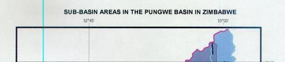
15 Figure 1 Map of Pungwe River basin Page 9 (94)
16 3 SETTLEMENTS, ADMINISTRATIVE FRAMEWORK AND NATURAL RESOURCES Page 10 (94)
17 3.1 Overview of Pungwe River basin settlements Settlements in the Pungwe River basin consist of rural village communities, a few scattered urban centres, small towns and growth points, as well as commercial farms. The city of Beira in Mozambique is the main urban and industrial centre. It has, however, been negatively affected by the current economic recession in. Administratively, the Pungwe River basin covers parts of Sofala and Manica provinces in Mozambique, and a large part of Mutasa Rural District in, as well as Nyanga National Park. A small portion of the basin in falls in Nyanga Rural District. Settlements are concentrated along the river valleys, floodplains and zones with agriculturally suitable soils, as well as in the proximity of existing infrastructure such as roads and administrative centres. 3.2 Settlements in Mozambique The Pungwe River basin in Mozambique is largely composed of rural settlements and villages, with the exception of the Beira/Dondo urban area. The majority of the population resides in scattered small village settlements. Outside the Beira and Dondo metropolitan area, only about 18% of the basin population are found in quasi-urban areas, which are usually constellations of villages with less than 20,000 inhabitants. The village communities are serviced by a town centre, which is normally the main focus for commercial activity, with services such as water supply, schools and health facilities. The surrounding village communities are completely rural with traditional residential areas that often lack basic infrastructure such as modern water supply and sanitation facilities. The typical town centre is usually located along the main road and is often the location for district headquarters. Outside the quasi-urban areas, conditions are completely rural. The two provinces that straddle the Pungwe River basin In Mozambique have altogether 37 wards, 23 administrative posts, ten districts and three cities. Table 1 below lists the rural districts and urban areas that either wholly or partially fall inside the basin. A total of 12 sub-basins have been identified, each with its own specific hydrological, climatic, agro-ecological and demographic characteristics, which have an influence on the existing and potential socio-economic activities. These are given in Table 2 below, by province and district, including the administrative centres or posts that fall inside each basin. Page 11 (94)
18 Table 1 Administrative Districts in the Pungwe River basin in Mozambique Province Sofala Province Manica Province District Beira City Dondo City Búzi Cheringoma Dondo Gorongosa Muanza Nhamatanda Barué Gondola Macossa Manica Page 12 (94)
19 Table 2 Pungwe Sub-basin, their Districts and Administrative Centres Sub Basins Manica Province Sofala Province District Admin Posts District Admin Posts Pungwe Manica Machipanda, Mavonde Honde Manica Machipanda, Mavonde Upper Pungwe Manica Vanduzi Barué Mavonde Catandica Choa Nhazonia Barué Catandica Nhampassa Macossa Nhamagua Upper Middle Pungwe Manica Vanduzi Macossa Nguawala Nhamagua Lower Middle Pungwe Gondola Amatongas Cafumpe Matsinho Gondola Gorongo-Sa (Vunduzi) Macossa Nguawala Gorongosa Sede Sede, Nhamadze Nhamagua Nhandu-Gue Macossa Nhamagua Gorongosa Vanduzi Sede Urema Gorongosa Sede Vanduzi Muanza Sede Cheringoma Sede Lower Pungwe Gondola Inchope Dondo Mafambisse Amatongas Nhamatanda Sede Tica Gorongosa Sede Muda Gondola Amatongas, Nhamatanda Sede Inchope Pungwe Estuary Buzi Sede Nhamatanda Sede Dondo Dondo City Beira City Tica Sede Mafambisse Page 13 (94)
20 Each of the above districts in the Pungwe River basin are further divided into wards. The characteristics of each sub-basin, which have an influence on water demand and the potential for development, are briefly outlined below. Pungwe This sub-basin covers the Mozambique- border areas of Manica Province. Settlements are scattered and sparsely populated because of mountainous terrain. Administrative posts are Machipanda and Mavonde. Honde Sub-basin Honde sub-basin covers part of Manica province. Administrative centres are located at Machipanda and Mavonde. The predominantly uneven terrain in this sub-basin renders it unsuitable for settlements. Population densities are therefore very low. The main economic attraction to the area is the presents of alluvial gold deposits in the Nyamakwarara River, which is informally mined. This has a negative impact on water quality. Upper Pungwe Sub-basin The Upper-Pungwe sub-basin occupies the high altitude areas in parts of Manica and Barue districts. There are four administrative posts that cater for the sub-basin populations at Vanduzi, Mavonde, Catandica and Choa. Despite above average rainfall, settlements are sparse due to the predominantly mountainous relief. However, the sub-basin has economic significance and potential for irrigation agriculture, wich is currently developped by Ausmoz, a large-scale agricultural operations company using large amounts of water. Nhazónia Sub-basin This sub-basin, which straddles the districts of Barue and Macosa, has administrative centres at Catandica, Nhapassa and Nhamagua. It has a very high potential for agricultural production because of good rains and fertile soils. Consequently, it contains the highest settlement density in the Pungwe River basin in Mozambique. Approximately 92% of the inhabitants of Barué district, and almost the entire population of Catandica and Nhapassa are located within Nhazonia sub-basin. Notwithstanding its suitability for agricultural production, farming is still predominantly subsistent, with very few large-scale commercial operations. Page 14 (94)
21 Upper-middle Pungwe Sub-basin The Upper-middle Pungwe sub-basin is sparsely populated. It covers parts of Manica and Macosa districts. The administrative posts of Vanduzi, Nguawala and part of Nhamagua fall inside the sub-basin. The majority of the inhabitants reside at Vanduzi, while the hinterland areas are largely uninhabited. These areas are mostly occupied by forests where game animals are also abundant. Lower-middle Pungwe Sub-basin This sub-basin covers part of Gondola District, where 55% of the district population is located. The majority of the inhabitants in the sub-basin are settled at Cafumpe, Matsinho and Vila de Gondola. Gondola district is considered to be one of the richest districts of Manica Province because of its high agricultural productivity. Part of the district falls inside the Buzi/Revue basin. At present, the main activity is subsistence farming, with a gradual trend towards the production and marketing of cash crops comprising cereals, vegetables and fruit. Gorongosa Sub-basin (Vundúzi) This sub-basin straddles Manica and Sofala Provinces. It covers parts of Macossa and Gorongosa districts. Administrative Centres are Nguawala, Sede, Nhamangua and Nhamadze. The majority of the inhabitants (approximately 89%) in this sub-basin are located in Gorongosa district where the climate is more suited to agricultural production. The rest of the sub-basin is poorly inhabited because it falls in the drier areas of Macossa District, occupied by forests. Game animals are also abundant. Nhandugué Sub-basin This sub-basin is poorly inhabited, with very few scattered settlements. It covers parts of Macossa District in Manica Province, and Gorongosa District in Sofala Province, with the largest part located in the former. Administrative centres are Nhamagua, Sede and Vanduzi. Urema Sub-basin This sub-basin is located in Sofala Province, and covers part of Gorongosa District, as well as Muanza and Cheringoma districts. Part of the sub-basin in Gorongosa District falls inside the Gorongosa National Park, which was previously unsettled. Currently, numerous settlements are beginning to sprout in and around the park. Any development plans within the national park will need to consider the sensitive nature of the ecosystem therein, as well as Page 15 (94)
22 requiring extensive consultations with the Parks authorities. Administrative centres in the basin include Sede and Vanduzi. Lower Pungwe Sub-basin This basin straddles Manica and Sofala provinces, within the districts of Gondola, Dondo, Nhamatanda and Gorongosa. It has the second highest population in the Pungwe River basin, the majority of which are located in Nhamatanda District. There are several administrative centres that support the sub-basin. The sub-basin covers the fertile Pungwe floodplain, which has a very high agricultural potential. Part of Mafambisse Sugar Estate falls inside the subbasin. Despite the high agricultural potential in sub-basin, there are only a few established large commercial farms and livestock breeders, including one group of small-scale commercial producers, which is in its early stages of development. The majority of the population practices subsistence farming. Riparian communities also undertake small-scale fishing operations. In some cases, communal farmers have been organised into farming associations, which use pedal pumps that are being promoted by NGOs, as well as the Provincial Department of Agriculture and Rural Development. Pungwe Estuary Sub-basin The Pungwe Estuary sub-basin, which is entirely located in Sofala Province, is the most populous in the Pungwe River basin in Mozambique, due to the existence of the densely populated urban centres of Beira and Dondo cities. In addition to being supplied with water from the Pungwe River, inhabitants of the two cities also use the floodplain for agricultural production. Nearly the entire population of Mafambisse administrative centre, as well as the majority of the population of Tica are located in the estuary. Economic activities include subsistence farming and small-scale fishing. The community residing at Mafambisse administrative is a source of labour for Mafambisse Sugar Plantation. There are also commercial farms in Dondo District in Mandruze Valley. Land-use in the Beira metropolitan area is a combination of urban settlement and agricultural activities. A household survey undertaken in showed that 64.8% of the households owned land in the green areas in Beira City or in other districts and neighbour provinces. The green land in Beira City is being rapidly developed for housing purposes. Consequently, in the future, many study involving 950 households in the City of Beira under the Beira-Dondo Structuring Plan. Page 16 (94)
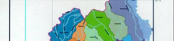
23 families are likely to seek farming land beyond Beira. This will increase the pressure on existing resources in the basin, particularly land, forests, wildlife and water. In general, district boundaries in the basin usually coincide with watercourses. Consequently, in contiguous sub-basins there is a tendency for district domains to straddle two or more sub-basins. In view of existing development disparities between districts, and within sub-basins, as well as the different levels of establishment and organisation of the private sector and civil society, the formulation of development scenarios on the basis of the sub-basin unit may not be feasible. The inherent disparities would make it impractical for the different stakeholders at district level to contribute equally towards development initiatives at the sub-basin level. A more feasible approach is the integration of sub-basins into larger zones, on the basis of socio-economic indicators such as hydrological characteristics, agricultural potential, the productivity of fisheries, and other natural resources associated with conservation areas, taking into account settlement densities and local government areas. 3.3 Settlements in The Pungwe River basin in is largely mountainous, with valley incisions along which numerous watercourses have formed. This characteristic relief and associated physiography has had a profound influence on the distribution of settlements. The prevalence of high rainfall and the perennial nature of local streams have led to the development of fairly intensive small-scale dry land and irrigated agriculture. In general, village settlements are concentrated in the valleys along watercourses, and on hillsides endowed with arable soils. Their nature is almost completely rural, with the exception of Hauna growth point, which is in the process of urbanisation. A service centre, which often has health, educational, and water supply services support each constellation of villages. Administratively, by far the largest part of the basin falls inside Mutasa Rural District. The northern section falls within Nyanga National Parks. A very small uninhabited enclave is part of Nyanga Rural District. Mutasa District is divided into several wards, demarcated on the basis of political representation, of which 14 either wholly or partially fall inside the basin. The Pungwe River basin map covering in Figure 2 shows the ward boundaries in Mutasa Rural District, including the distribution of village settlements. Page 17 (94)
24 Land use is characterised by the following activities: Communal area semi-subsistence farming spanning the central part of the basin in a north-easterly direction; Large-scale tea and coffee plantations in the north-east; Nyanga National Park in the north-west; Large-scale forest plantations in the west and south-east. Page 18 (94)
25 Figure 2 Ward Boundaries in the Pungwe River basin in Page 19 (94)
26 A brief description of settlements in the Pungwe River basin in is given below, by ward: Chikomba Ward 1 This is the most densely settled ward in the Pungwe River basin in. Traditional village communities are located along the Ruera River, which forms part of the boundary with Mozambique, and its tributaries. Communities draw most of their water for domestic and irrigation purposes from the Ruera and its tributaries, the Mtangaza and Nyamkombe. A smaller portion is sourced from the Pungwe River. Once river flow reaches the Pungwe, abstraction in the absence of pumping becomes difficult due to the steep sided stream banks and valley. Eastern Highlands Plantations - Ward 2 This area consists of the large-scale commercial Aberfoyle tea plantations. The tea plantation estate operates a club, a clinic and primary school, and Wamba tea processing factory. Two main rivers, the Nyawamba and Nyamhunga, flow through the estate to join the Pungwe River, which forms the southern boundary of Ward 2. A large dam has been developed by the estate on the Nyawamba River for irrigation and domestic purposes. Zindi - Ward 3 This ward is characterised by steep-sided river valleys, such that settlements tend to be scattered on arable hill-sides. The main rivers are Nyamhingura, Chitema and Nyamawanga, which enter the Pungwe River on the southern boundary of the ward. In addition to communal area subsistence farming, there is also a small-scale tea scheme at Rumbizi, which is operated by nearby settlers. Communal villagers have an out-growing arrangement with the larger Aberfoyle tea estate. Mandeya - Ward 4 In this ward, village communities are mainly concentrated along main roads, with subsistence farming being practised along river valleys and on hillsides. Mandeya ward has the highest coverage of hill-side cultivation. The major tributaries are the Nyamatsupa and the Muzinga rivers which enter the Pungwe River along the northern boundary of the ward. Numerous perennial streams drain the cultivated hillsides into the Nyamatsupa River, and have been extensively exploited for irrigation by village communities by means of make-shift installations. The ward is serviced by several business centres, schools and health centres. Page 20 (94)
27 Muparutsa - Ward 5 This ward is bounded by the Pungwe River to the north, the Honde River to the south, and Ruda and Marirangwe rivers to the west and east respectively. Settlements are concentrated along the Ruda River and main roads. Due to the hilly nature of the landscape, cultivation is largely undertaken on hillsides. The Ruda River and its tributaries supply most of the domestic and irrigation water to the settlements, since access to Pungwe and Honde River water is limited by the banks and steep valley sides. Samanga A - Ward 6 This ward lies between Nyanga National Park to the north, Honde River to the south, Ruda River to the east and north-east and Mtarazi River to the west. Village communities are concentrated along main roads, the Ruda River, Boyoyo River, and in the Honde Valley. The latter supports extensive agricultural activities under irrigation from the numerous mountain tributaries of the Honde River. Several piped schemes also draw water from the Ruda River to supply village communities, including Hauna growth point, which is situated in the ward. Hauna Growth Point is in its transitional stage of full urbanisation. It is the main centre for commercial and agricultural marketing activities in the fertile Honde Valley. Due to its status as a growth point, provisions have been made in the town plan for modern housing, institutional, commercial and industrial development. Over the years, the centre has experienced phenomenal growth in the housing and commercial sectors. The ward also has another large business centre at Gatsi, located on the main road to Katiyo Tea Estate. Samanga B - Ward 7 Samanga B ward is bounded by Mtarazi River to the east, Duru River to the west, the Honde River to the south and Nyanga National Park to the north. Village settlements are concentrated on hillsides to the north of the main road to Katiyo Tea Estate, which are heavily incised by numerous mountain streams, mostly tributaries of the Nyamakanga River, that supply both irrigation and domestic water. Other settlements are found along the main road to Katiyo and in the higher areas of the Honde Valley. In the latter, dry land farming is largely practiced due to the difficulty associated with abstracting irrigation water from the main Honde River. The Manunure irrigation scheme, a major agricultural development in the district, is located in the ward. It draws water from the Duru River. The Page 21 (94)
28 aesthetic Duru Falls, on the boundary with Sanyamandwe Ward have a good potential for hydroelectric power generation. Sanyamandwe - Ward 11 Sanyamandwe Ward is located between the Honde River to the south, Nyanga National park to the north and Duru River to the east. Land use consists of forestry plantations to the north-east owned by wattle company, statelands and scattered communal area settlements on flatter ground to the south and east. Agriculture in the communal area is predominantly dry land. Nyamaende - Ward 9 This ward is located south of Honde River and is bounded by the - Mozambique border to the east. Terrain is very hilly, with settlements scattered on hillsides and a small section of the Honde Valley. A major tributary of the Honde, the Ngarura River, flows north through the ward. It has numerous mountain tributaries that supply both irrigation and domestic water. The divide between the Honde and Nyamakwarara river systems lies to the south of the ward, where it spans in a north-easterly direction. Agriculture is generally limited by the rugged hilly terrain. Sahumani Ward 8 This ward, which is bordered by the Honde River to the north, is drained by the Ngarura River to the west and the Mupenga River to the east, both major tributaries of the Honde. The upper drainage areas of the two tributaries are mountainous, very rugged, and thus unsuitable for settlements. Isolated village settlements are found in the middle reaches, which increase in density towards the Honde river. These are accompanied with cultivated areas on the hill slopes and in the Honde valley. The numerous mountain tributaries provide extensive scope for irrigation, albeit constrained by limited arable land. Samaringa - Ward 10 This ward is bounded by Mupenga River to the east and Honde River to the North. The former drains rugged mountainous terrain in the south-east, with limited availability of arable land despite abundant water. Settlements are concentrated in the middle reaches of the Mupenga River where hill slopes become milder. The north-western part of the basin largely lies in the Honde Valley. It is moderately settled and supports mainly dry-land farming. Although irrigation water is available from the Honde River, it is not possible to divert it by gravity because of the steep sided deep valley. Page 22 (94)
29 The famous Honde Mission is located in the north-eastern part of the ward, including the thriving Honde business centre. Government institutions such as the Agricultural Extension Services are also found at the centre. Chidazembe - Ward 19 This ward consists of communal area settlements to the north and resettlement area communities to the south. Relief is generally flat and undulating across the few drainage channels. The headwaters of the Honde River originate in this ward. Other smaller tributaries of the Honde are Matinedza, Manama and Mucheri Rivers. Agriculture is predominantly dry land practised by the few scattered settlements. Stapleford - Ward 27 This ward covers Stapleford Forest, which is owned and operated by the Forestry Company of. Settlements comprise workers compounds and administrative offices, including the John Meikle Forestry Research Centre, Mukandi forestry nurseries, Rupinda School and Old Maguwa School. The landscape is mountainous and densely incised by numerous watercourses, which form tributaries of the Nyamakwarara River. Land use is entirely a mixture of indigenous and exotic forest. Odzani - Ward 18 This ward forms a small enclave in the south-eastern corner of the Pungwe River basin in. Land-use is entirely large-scale commercial forest plantations. Settlements consist of workers quarters and other ancillary buildings. Page 23 (94)
30 4 DEMOGRAPHIC PROFILE OF THE PUNGWE RIVER BASIN Page 24 (94)
31 4.1 General overview The respective population data for the Pungwe River basin in Mozambique and has been obtained from the 1997 and 2002 population censuses, to district and enumeration area levels. The previous section showed that, with the exception the Beira/Dondo metropolitan area, basin settlements are predominantly rural. Their distribution is generally influenced by the availability of water, arable land and infrastructure services such as main roads and administrative centres. As at year 2003, the Pungwe River basin has an estimated total population of , broken down by basin country as shown in Table 3 below. Table 3 Summary of Pungwe River basin Population Basin Country Population % of Basin Total Sub-basin Area [km 2 ] % of Sub-basin Area to Total Basin Area Mozambique % % % % Total From Table 3, above, it is evident that in general, population density in the Pungwe River basin in is higher than that for Mozambique. Notwithstanding this generality, the distribution of population in Mozambique tends to be denser in hinterland areas around towns and administrative centres, and along main roads. The remote areas are thus even more sparsely populated. In, abundant water and fertile soils in the Honde and Pungwe valleys are conducive to intensive agriculture, which supports the higher population density. In general there is a higher potential for new water resources and conservation based developments in Mozambique compared to. Nevertheless, in the latter, there are opportunities to build on ongoing agricultural based activities through investments in more efficient irrigation systems and value enhancing food-processing and related industries. The distribution of Pungwe River basin population and projections thereof are given in the following subsections. Page 25 (94)
32 4.2 Distribution of present Pungwe River basin population Pungwe River basin in Mozambique Current Population Table 4 below gives the population by district for the Pungwe River basin in Mozambique from the 1997 National Census and projections for year The study has identified 12 sub-basin areas of the Pungwe River basin in Mozambique described in the previous section (see Table 2). Table 5 below gives the estimated population sizes for each sub-basin for year Table 4 Population by District for the Pungwe River basin in Mozambique District Estimated Population 1997 Census 2003 Projection Sofala Province Beira/Dondo City Búzi district Cheringoma D Dondo Dist Gorongosa D Muanza Dist Nhamatanda D Total For Sofala Province Manica Province Barué Dist Gondola Dist Macossa Dist Manica Dist Total for Manica Province Total for Basin in Mozambique The three urban centres of Beira and Dondo account for the highest population in the basin. Although they partially fall inside the basin, their source of water is entirely from the Pungwe River 1. Chimoio also partially falls 1 In the City of Beira, the population of Nhangau administrative post was not considered a rural areas therefore it is not likely that it will receive water supplies using a piped water system. Page 26 (94)
33 inside the basin. However, the bulk of its water supply comes from the Chicamba Dam in the Buzi River basin. Table 5 Estimated Population of Pungwe River basin in Mozambique by Sub-basin Sub-basin Estimated Population 2003 Projection Pungwe 840 Honde Upper Pungwe Nhazonia Upper Middle Pungwe Lower Middle Pungwe Gorongo-Sa (Vunduzi) Nhandu-Gue Urema Lower Pungwe Muda Pungwe Estuary Total Population The districts of Gorongosa, Nhamatanda and Dondo in Sofala Province almost entirely fall inside the basin. Between them they account for nearly 30% of the basin population in Mozambique. In Manica Province, Barué District has the largest area in the basin at 70%, but accounts for only 7% of the basin population. Population density in the portion of the district within the basin is therefore sparse. On the other hand, Gondola District with 58% of its area inside the basin accounts for 11% of the basin population. Outside the urban areas of Beira/Dondo, it therefore has the highest population density. This is due to its location on the plateau, which has fertile soils and good climate. It is also strategically positioned along the Beira Corridor. Of conservation significance, is the concentration within the GNP of the populations of Gorongosa, Muanza and Cheringoma Districts in Sofala Province, and Macossa District in Manuka Province, where they practice shifting cultivation. Any future development plans should address the issue of conservation in the national park to ensure the protection of the floodplain ecosystem for the benefit of these communities. The most populated sub-basin is the Pungwe Estuary, which accommodates 56.3% of the Pungwe River basin population. This is due to the high Page 27 (94)
34 population density in the Beira/Dondo urban area, which is part of the subbasin. As expected Pungwe sub-basin has the least population with 0.8% of the basin total due to the mountainous terrain. Urban population from Beira and Dondo cities accounts for nearly 49% of the basin population, while the other 51% is rural population. Presently, the rural populations in Mozambique do not make extensive use of water from the basin but in the future there could be an increase pressure on water supplies from the basin, as the consumption of clean water in the rural areas and the use of irrigation techniques in farming and cattle raising are on the increase Pungwe River basin in As mentioned earlier, by far the largest part of the Pungwe River basin in lies in Mutasa Rural District, with a small, unpopulated area situated in the Nyanga Rural District. The latter comprises largely unpopulated commercial forest, national park and state lands. There are no major cities or towns within the basin, with the exception of Hauna growth point. The rest of the basin contains rural villages, small service centres and institutions such as schools. Although the city Mutare draws part of its water from the Pungwe River, through a fixed water permit, it is located outside the basin. Its population dynamics will therefore not be considered in this study. Population estimates for the Pungwe River basin in have been based on the results of the 2002 National Census. Census data is available to the level of enumeration area. These are discrete domains within a single ward, usually demarcated on the basis of the location of village settlements. The distribution of population in the district largely depends on land use, and is characterised by dense population clusters along streams, and in pockets of arable land. The terrain is mountainous, and incised by fertile valleys that form perennial streams. Table 6 below gives the breakdown of population in the district wards that fall inside the Pungwe River basin in. Page 28 (94)
35 Table 6 Pungwe River basin Population in by Ward Ward Population 2002 Ward 1:Chikomba Ward 2: E/H Plantation Ward 3: Zindi Ward 4: Mandeya Ward 5: Muparutsa Ward 6: Samanga A Ward 7: Samanga B Ward 8: Sahumani Ward 9: Nyamaende Ward 10: Samaringa Ward 11: Sanyamandwe Ward 19: Chidazembe Ward 27: Stapleford 435 TOTAL Demographic analysis of the district as a whole based on the intercensal period 1992 to 2002 indicates that its population has risen from to , a paltry increase of 0.9%. This lends credence to demographic trends throughout that show increasing rural to urban migration over the years. There may also be other influencing factors on rural demography such as HIV/AIDS. Thus it is likely that the rural population may remain static or even decrease in the foreseeable future. To facilitate the evaluation of water demand from the numerous perennial streams, the Pungwe River basin in has been divided into subbasins based on the major tributaries of the Pungwe and Honde rivers. These are shown on the map in Figure 3. The population falling inside each subbasin is estimated from the enumeration area (EA) population for the recent 2002 census. Table 7 gives the current population for the Pungwe River basin in by sub-basin area. A breakdown by enumeration area is given in Appendix 1, which also shows the wards straddled by each sub-basin area. Page 29 (94)
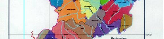
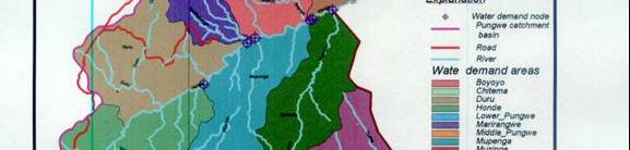
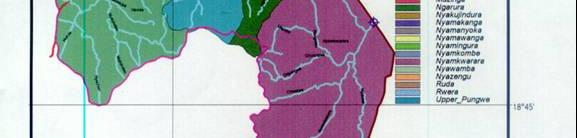
36 Figure 3 Sub-basins of the Pungwe River basin in Page 30 (94)
37 Table 7 Population Distribution by Sub-basin in the Pungwe River basin in Sub-basin Area Population 1. Ruera River Nyamkombe R Lower Pungwe Nyawamba R Nyamhingura R Chitema River Nyamawanga R Middle Pungwe R Nyazengu R Upper Pungwe R Muzinga R Nyamanyoka R Nyakujindura R Marirangwe R Ruda River Boyoyo River Nyamakanga R Duru River Nyagura R Mupenga River Honde River Nyamakwarara R Note that Nyazengu and Upper Pungwe sub-basins, which fall inside the national park and the southern portion of Nyanga Rural District, have no population due to the absence of settlements. The most populous sub-basins are the Honde, Duru, Mupenga, Nyamkombe and Ruda. This is because of the wide valleys, which provide more arable land, coupled with larger quantities of water from the numerous tributaries. The Duru River has a large irrigation scheme, which caters for residents of Manunure Village. Hauna growth, including several schools and business centres, falls inside Ruda sub-basin. The Nyamakwarara sub-basin has the lowest population despite having the largest area. This is because most of it is uninhabited forestland. Page 31 (94)
DEVELOPMENT OF THE PUNGWE RIVER BASIN JOINT INTEGRATED WATER RESOURCES MANAGEMENT STRATEGY THE PUNGWE RIVER MONOGRAPH
 Government of the Republic of Mozambique Government of the Republic of Zimbabwe Swedish International Development Cooperation Agency (Sida) DEVELOPMENT OF THE PUNGWE RIVER BASIN JOINT INTEGRATED WATER
Catchment and Lake Research
 LARS 2007 Catchment and Lake Research Multilateral versus bilateral agreements for the establishment of river based organizations: comparison of legal, economic and social benefits in the Zambian experience.
REPUBLIC OF MOZAMBIQUE SOFALA PROVINCE
 REPUBLIC OF MOZAMBIQUE SOFALA PROVINCE PRESENTATION ON THE OCCASION OF THE BUSINESS SEMINAR INVESTING IN SOFALA, MOZAMBIQUE Centurion Lake Hotel, Pretória 22 JUNE 2012 1 Ladies and gentlemen, distinguished
PUNGWE RIVER BASIN. Government of the Republic of Mozambique Government of the Republic of Zimbabwe. A monograph of the
 Government of the Republic of Mozambique Government of the Republic of Zimbabwe A monograph of the PUNGWE RIVER BASIN - LIGHT EDITION A part of the project: DEVELOPMENT OF THE PUNGWE RIVER BASIN JOINT
SIAVONGA DISTRICT
 SIAVONGA DISTRICT --------------------------------------------------------------------------------------------------------- 1.0 Physical Environment Siavonga District is characterized by an escarpment
PPCR/SC.4/5 October 9, Meeting of the PPCR Sub-Committee Washington, D.C. October 28, REVIEW OF ON-GOING WORK OF THE MDBs IN DJIBOUTI
 PPCR/SC.4/5 October 9, 2009 Meeting of the PPCR Sub-Committee Washington, D.C. October 28, 2009 REVIEW OF ON-GOING WORK OF THE MDBs IN DJIBOUTI Proposed Sub-Committee Decision The Sub-Committee reviewed
PERMANENT MISSION OF BELIZE TO THE UNITED NATIONS
 PERMANENT MISSION OF BELIZE TO THE UNITED NATIONS 675 Third Ave. Suite 1911 New York, New York 10017 Tel: (212) 986-1240/(212) 593-0999 Fax: (212) 593-0932 E-mail: blzun@belizemission.com STATEMENT DELIVERED
SECTOR ASSESSMENT (SUMMARY): Transport, and Information and Communication Technology - Air Transport 1
: Transport, and Information and Communication Technology - Air Transport 1") Air Transport Connectivity Enhancement Project (RRP BHU 44239-013) SECTOR ASSESSMENT (SUMMARY): Transport, and Information and Communication Technology - Air Transport 1 Sector Road Map 1. Sector Performance,
Air Transport Connectivity Enhancement Project (RRP BHU 44239-013) SECTOR ASSESSMENT (SUMMARY): Transport, and Information and Communication Technology - Air Transport 1 Sector Road Map 1. Sector Performance,
CITY OF WINDHOEK DEPARTMENT OF PLANNING, URBANIZATION AND ENVIRONMENT
 CITY OF WINDHOEK DEPARTMENT OF PLANNING, URBANIZATION AND ENVIRONMENT Geographical Location Namibia is a developing country located on the south-western coast of Africa. It is an immensely semi-arid and
BABIA GÓRA DECLARATION ON SUSTAINABLE TOURISM DEVELOPMENT IN MOUNTAIN AREAS
 BABIA GÓRA DECLARATION ON SUSTAINABLE TOURISM DEVELOPMENT IN MOUNTAIN AREAS The participants of the International Workshop for CEE Countries Tourism in Mountain Areas and the Convention on Biological Diversity",
PRIMA Open Online Public Consultation
 PRIMA Open Online Public Consultation Short Summary Report Published on 1 June 2016 Research and Introduction Objective of the consultation: to collect views and opinions on the scope, objectives, and
"ST. KLIMENT OHRIDSKI FACULTY OF GEOLOGY AND GEOGRAPHY
 SOFIA UNIVERSITY "ST. KLIMENT OHRIDSKI FACULTY OF GEOLOGY AND GEOGRAPHY APPLICATION OF THE MODEL "DRIVING FORCES PRESSURE STATE - RESPONSE FOR ASSESSMENT OF FLOOD RISK RADOSTINA BORISOVA DOCHEVA Bachelor
2. Introduction to Kurunegala Area : 2.1 Location and History : 2.2 Regional Aspects :
 2. Introduction to Kurunegala Area : 2.1 Location and History : Kurunegala town is the capital of Kurunegala district as well as the capital of North Western Province (Fig 2.1). It has been administered
Stakeholder Perspectives on the Potential for Community-based Ecotourism Development and Support for the Kgalagadi Transfrontier Park in Botswana
 Stakeholder Perspectives on the Potential for Community-based Ecotourism Development and Support for the Kgalagadi Transfrontier Park in Botswana Naomi Moswete, University of Botswana Brijesh Thapa, University
SUMMER VILLAGE OF SILVER SANDS. Municipal Development Plan
 SUMMER VILLAGE OF SILVER SANDS Municipal Development Plan Bylaw 253-2014 Adopted August 22, 2014 Summer Village of Silver Sands Municipal Development Plan Bylaw No. 253-2014 Page 2 1 INTRODUCTION 1.1 SETTING
Geoscape Toronto The Oak Ridges Moraine Activity 2 - Page 1 of 10 Information Bulletin
 About 13,000 years ago as the Laurentide Ice Sheet melted, glacial meltwater accumulated between the ice sheet and the Niagara Escarpment. This formed a lake basin into which gravel and sand were deposited.
Chapter 21: EAST AFRICA
 Chapter 21: EAST AFRICA Physical Geography of East Africa Landforms East Africa is a diverse landscape of different plains, volcanic mountains, and plateaus cut by a large valley and marked by many rivers
Sustainable Rural Tourism
 Sustainable Rural Tourism Tourism: its nature and potential Tourism = multifaceted economic activity + strong social element Definition of tourism by the World Tourism Organisation (WTO): tourism comprises
SHARE Toolkit: Case Studies. Integrated management of the Senegal River. IUCN Water Programme. By Madiodio Niasse. 1. Origin and Background
 IUCN Water Programme SHARE Toolkit: Case Studies Integrated management of the Senegal River By Madiodio Niasse 1. Origin and Background The Senegal River is 1,800 kilometres long. It originates from the
Biosphere Reserves of India : Complete Study Notes
 Biosphere Reserves of India : Complete Study Notes Author : Oliveboard Date : April 7, 2017 Biosphere reserves of India form an important topic for the UPSC CSE preparation. This blog post covers all important
Tourism and Wetlands
 CONVENTION ON WETLANDS (Ramsar, Iran, 1971) 43 rd Meeting of the Standing Committee Gland, Switzerland, 31 October 4 November 2011 DOC. SC43-27 Tourism and Wetlands Action requested. The Standing Committee
Aqqaba Village Profile
 Aqqaba Village Profile Produced by The Applied Research Institute - Jerusalem In cooperation with Funded by February, 2006 This document has been produced with the financial assistance of the European
URBAN DYNAMICS WESTERN CAPE 67
 URBAN DYNAMICS WESTERN CAPE 67 5. SOCIO-ECONOMIC CONTEXT 5.1 Demographic Profile 5.1.1 Introduction The demographic information contained in the synopsis is derived from the supposedly inaccurate 2001
Chapter V Comparative Analysis
 Chapter V Comparative Analysis This chapter will explore/explain analysis comparison about the sustainable tourism development in small islands, with the case of Malta and Indonesia, represents by Morotai
COUNTRY CASE STUDIES: OVERVIEW
 APPENDIX C: COUNTRY CASE STUDIES: OVERVIEW The countries selected as cases for this evaluation include some of the Bank Group s oldest (Brazil and India) and largest clients in terms of both territory
HELLENIC REPUBLIC Voluntary National Review on the Implementation of the 2030 Agenda for Sustainable Development. 16 July 2018
 HELLENIC REPUBLIC Voluntary National Review on the Implementation of the 2030 Agenda for Sustainable Development 16 July 2018 1 HELLENIC REPUBLIC Voluntary National Review on the Implementation of the
Theme A ECOTOURISM DEVELOPMENT IN TANZANIA : THE SUSTAINABILITY CHALLENGE
 Theme A STATEMENT BY MR. PHILEMON L. LUHANJO, PERMANENT SECRETARY, MINISTRY OF NATURAL RESOURCES AND TOURISM-TANZANIA, AT THE SUMMIT OF CELEBRATION OF THE INTERNATIONAL YEAR OF ECOTOURISM, QUEBEC CANADA,
This section of the Plan provides a general overview of the Smoky Mountain Region. It consists of the following four subsections:
 SECTION 3 COMMUNITY PROFILE This section of the Plan provides a general overview of the Smoky Mountain Region. It consists of the following four subsections: 3.1 Geography and the Environment 3.2 Population
Global Sustainable Tourism Destinations Criteria
 Global Sustainable Tourism Destinations Criteria Draft destination level Global Sustainable Tourism Criteria as proposed after Destinations and International Standards joint working group meeting and follow-up
CHAPTER IV OVERVIEW. Indonesia. The capital is Dompu. Dompu Regency has an area of 2, km².
 CHAPTER IV OVERVIEW A. General Description of the Research Sites Dompu Regency, is a district in West Nusa Tenggara Province, Indonesia. The capital is Dompu. Dompu Regency has an area of 2,321.55 km².
Figure 1.1 St. John s Location. 2.0 Overview/Structure
 St. John s Region 1.0 Introduction Newfoundland and Labrador s most dominant service centre, St. John s (population = 100,645) is also the province s capital and largest community (Government of Newfoundland
QUÉBEC DECLARATION ON ECOTOURISM World Ecotourism Summit Québec City, Canada, 2002
 QUÉBEC DECLARATION ON ECOTOURISM World Ecotourism Summit Québec City, Canada, 2002 The participants at the Summit acknowledge the World Summit on Sustainable Development (WSSD) in Johannesburg, August/September
Buyondo Herbert. January 15 th to 18 th 2017
 PILOTS FOR PERPETUAL CENSUSES: COMMUNITY BASED DATA COLLECTION UGANDAN EXPERIENCE Presentation made at the UN World Data Forum Cape Town South Africa By Buyondo Herbert Principal Statistician Uganda Bureau
GOAL. Achieve gender equality and empower all women and girls NATURE COUNT$ How do ecosystems and biodiversity support this SDG?
 NATURE COUNT$ GOAL 5 Achieve gender equality and empower all women and girls Photo: UNDP Afghanistan/Robert Few SDG 5 promotes equality between men and women through the elimination of discrimination,
Bardala village profile
 Bardala village profile Produced by The Applied Research Institute - Jerusalem In cooperation with Funded by February, 2006 This document has been produced with the financial assistance of the European
A vision for a healthier, more prosperous and secure future for all coastal communities. Can Gio Biosphere Reserve 2010 IUCN Vietnam MERD
 A vision for a healthier, more prosperous and secure future for all coastal communities Can Gio Biosphere Reserve 2010 IUCN Vietnam MERD Local woman caring for mangroves in Hau Loc, Thanh Hoa CARE International
NATIONAL DEVELOPMENT STRATEGY AND NATIONAL ICT STRATEGY INTEGRATION: MEETING THE MDGs AND WSIS DECLARATION
 NATIONAL DEVELOPMENT STRATEGY AND NATIONAL ICT STRATEGY INTEGRATION: MEETING THE MDGs AND WSIS DECLARATION Conference for Regional Policy Makers and Advisers Caribbean Development Bank Bridgetown, 30 September
INVITATION FOR EXPRESSION OF INTEREST
 1. Introduction INVITATION FOR EXPRESSION OF INTEREST Indah Water Konsortium Sdn Bhd (Company No. 211763-P) ( IWK ) is seeking for Expression of Interest (EOI) from consultants registered with the Ministry
WORKING DOCUMENT. Mediterranean Strategy for Sustainable Development (MSSD ): Assessment of Tourism component. June 2016
: Assessment of Tourism component. June 2016") Building the Mediterranean future together WORKING DOCUMENT June 2016 Mediterranean Strategy for Sustainable Development (MSSD 2005-2015): Assessment of Tourism component MSSD Objectives Obj. 1: Contribute
Building the Mediterranean future together WORKING DOCUMENT June 2016 Mediterranean Strategy for Sustainable Development (MSSD 2005-2015): Assessment of Tourism component MSSD Objectives Obj. 1: Contribute
Community Development and Tourism Recovery. M.I.M. Rafeek Secretary Ministry of Tourism & Sports SRI LANKA
 Community Development and Tourism Recovery M.I.M. Rafeek Secretary Ministry of Tourism & Sports SRI LANKA Sri Lanka Tourism at a Glance Historically renown landmark in global travel map Significant geographical
THE SAN JUAN RIVER BASIN PROJECT
 Formulation of a Strategic Actions Program for the Integrated Management of the Hydrological Resources and Sustainable Development of the San Juan River Basin and its Coastal zone PROCUENCA SAN JUAN THE
The Sunshine Coast is part of the global community and generates wealth through export, high-value industries and new investment.
 3.2 Strategic intent 3.2.1 Shaping growth an overview In 2031, the Sunshine Coast is renowned for its vibrant economy, ecological values, unique character and strong sense of community. It is Australia
COMMUNITY BASED TOURISM DEVELOPMENT (A Case Study of Sikkim)
") COMMUNITY BASED TOURISM DEVELOPMENT (A Case Study of Sikkim) SUMMARY BY RINZING LAMA UNDER THE SUPERVISION OF PROFESSOR MANJULA CHAUDHARY DEPARTMENT OF TOURISM AND HOTEL MANAGEMENT KURUKSHETRA UNIVERSITY,
COMMUNITY BASED TOURISM DEVELOPMENT (A Case Study of Sikkim) SUMMARY BY RINZING LAMA UNDER THE SUPERVISION OF PROFESSOR MANJULA CHAUDHARY DEPARTMENT OF TOURISM AND HOTEL MANAGEMENT KURUKSHETRA UNIVERSITY,
CHAPTER 12. South America. Section 1: Natural Environments Section 2: History and Culture Section 3: South America Today. HOLT World Geography
 CHAPTER 12 South America Section 1: Natural Environments Section 2: History and Culture Section 3: South America 1 Section 1 Natural Environments Objectives: What are the major landforms and rivers of
Dr. Dimitris P. Drakoulis THE REGIONAL ORGANIZATION OF THE EASTERN ROMAN EMPIRE IN THE EARLY BYZANTINE PERIOD (4TH-6TH CENTURY A.D.
 Dr. Dimitris P. Drakoulis THE REGIONAL ORGANIZATION OF THE EASTERN ROMAN EMPIRE IN THE EARLY BYZANTINE PERIOD (4TH-6TH CENTURY A.D.) ENGLISH SUMMARY The purpose of this doctoral dissertation is to contribute
Zimbabwe. Provincial Report Manicaland
 Zimbabwe Provincial Report Manicaland ZIMBABWE POPULATION CENSUS 2012 Population Census Office P.O. Box CY342 Causeway Harare Tel: 04-793971-2 04-794756 E-mail: census2012@zimstat.ac.zw Census Results
UNESCO-IUCN Monitoring Mission to Mount Kenya National Park/Natural Forest World Heritage Site, Kenya January 2003
 In the framework of the UNESCO/Italy Funds in Trust Cooperation for the preservation of World Heritage UNESCO-IUCN Monitoring Mission to Mount Kenya National Park/Natural Forest World Heritage Site, Kenya
HIGH-END ECOTOURISM AS A SUSTAINABLE LAND USE OPTION IN RURAL AFRICA:
 HIGH-END ECOTOURISM AS A SUSTAINABLE LAND USE OPTION IN RURAL AFRICA: THE ROLE OF EMPLOYMENT IN POVERTY REDUCTION & SOCIAL WELFARE Sue Snyman, March 2011 sues@wilderness.co.za INTRODUCTION Rural Communities
POVERTY REDUCTION THROUGH COMMUNITY-BASED TOURISM IN VIET NAM: A CASE STUDY
 POVERTY REDUCTION THROUGH COMMUNITY-BASED TOURISM IN VIET NAM: A CASE STUDY A paper contributed by the ITC Export-led Poverty Reduction Programme Team (EPRP) POVERTY REDUCTION THROUGH COMMUNITY-BASED TOURISM
Slum Situation Analysis
 Slum Situation Analysis Components of a slum upgrading programme 1. SLUM SITUATION ANALYSIS 2. REVIEW OF POLICIES AFFECTING SLUM AREAS 3. SLUM UPGRADING AND PREVENTION STRATEGY 4. RESOURCE MOBILISATION
Sustainable development: 'Lanzarote and the Biosphere strategy'. LIFE97 ENV/E/000286
 Sustainable development: 'Lanzarote and the Biosphere strategy'. LIFE97 ENV/E/000286 Project description Environmental issues Beneficiaries Administrative data Read more Contact details: Project Manager:
SEA for oil and gas development in Southern Africa is it effective? Bryony Walmsley Southern African Institute for Environmental Assessment
 SEA for oil and gas development in Southern Africa is it effective? Bryony Walmsley Southern African Institute for Environmental Assessment Outline Key environmental and social issues Current interest
Activity Concept Note:
 Activity Concept Note: Summary Provide a short summary of the proposed Activity including indicative New Zealand funding level and note whether this is a New Zealandled or partner-led process. Why: Rationale
The influence of producer s characteristics on the prospects and productivity of mastic farms on the island of Chios, Greece
 The influence of producer s characteristics on the prospects and productivity of mastic farms on the island of Chios, Greece H. Theodoropoulos* and C. D. Apostolopoulos Harokopio University, El. Venizelou
Town of Oakfield Agricultural and Farmland Protection Plan
 SECTION III COMMUNITY OVERVIEW A. Regional Setting / Location The Town of Oakfield is located in the northwestern portion of Genesee County. Located west of New York's Finger Lakes, the Town is uniquely
Promoting Tourism as an Engine of Inclusive Growth and Sustainable Growth in Africa. Egyptian Minister of Tourism YEHIA RASHED
 Promoting Tourism as an Engine of Inclusive Growth and Sustainable Growth in Africa Egyptian Minister of Tourism YEHIA RASHED JULY 21, 2016 International tourism highlights (2015): Introduction: Tourism
Getting Rural Youth Ready for Work in Burma. (Myanmar) Project No:
 Project No:") Final Technical Report Getting Rural Youth Ready for Work in Burma Supported by (Myanmar) Project No: 108265-001 Implemented by Tag International Development Yangon, Myanmar 31 st January 2017 Implemented
Final Technical Report Getting Rural Youth Ready for Work in Burma Supported by (Myanmar) Project No: 108265-001 Implemented by Tag International Development Yangon, Myanmar 31 st January 2017 Implemented
UGANDA S URBAN DEVELOPMENT; A SCRUTINY OF TRANSPORT PLANNING AND MOBILITY IN TOWNS AND CITIES
 UGANDA S URBAN DEVELOPMENT; A SCRUTINY OF TRANSPORT PLANNING AND MOBILITY IN TOWNS AND CITIES BY Mutabazi Sam Stewart Executive Director Uganda Road Sector Support Initiative (URSSI) P.O Box 11110 Kampala,
Communities and conservation in West Kilimanjaro, Tanzania: Participation, costs and benefits
 Communities and conservation in West Kilimanjaro, Tanzania: Participation, costs and benefits Lokalsamfunn og naturvern i Vest-Kilimanjaro, Tanzania: Deltakelse, kostnader og nytte Philosophiae Doctor
Government Gazette REPUBLIC OF SOUTH AFRICA
 Please note that most Acts are published in English and another South African official language. Currently we only have capacity to publish the English versions. This means that this document will only
SIGNING CEREMONY. Comoros Decent Work Country Programme 4 May 2015
 SIGNING CEREMONY Comoros Decent Work Country Programme 4 May 2015 Address by Mr Aenaes Chapinga Chuma ILO Assistant Director-General and Regional Director for Africa - Your Excellency Dr Ikililou DHOININE,
SANBI PLANNING FORUM
 SANBI PLANNING FORUM SPATIAL PLANNING IN PROTECTED AREAS AND THEIR BUFFERS (South Africa) Ms Jayshree Govender, Dr Mike Knight and Mr Russell Smart 22 June 2017 OUTLINE 1) Introduction 2) Protected areas
Credit No IN. National Project Director 9,Institutional Area, Lodhi Road, New Delhi Tel:
 Sub:Selection of Consultants for preparation of eco-tourism management plan forvedaranyam area in Tamil Nadu. ICZMP (Integrated Coastal Zone Management Project) Credit No. 4765 0 IN Amendment #1 The TOR
SUSTAINABLE ECOTOURISM DEVELOPMENT IN THE EMBERÁ INDIGENOUS COMMUNITIES, CHAGRES NATIONAL PARK, PANAMA
 SUSTAINABLE ECOTOURISM DEVELOPMENT IN THE EMBERÁ INDIGENOUS COMMUNITIES, CHAGRES NATIONAL PARK, PANAMA Authors: Gerald P. Bauer Natural Resource & Environmental Advisor US Forest Service, International
1. International Conventions 2. South African Legislation 3. Swaziland Legislation
 A. Legal context WATER FOR EVER 1. International Conventions 2. South African Legislation 3. Swaziland Legislation B. Evolution of KOBWA 1. Treaties 2. Evolution Stages 3. Main Objectives 4. Need for Bi-national
Case Study: 1. The Clarence River Catchment
 Case Study: 1. The Clarence River Catchment The NSW coastline is a great natural asset, making an enormous contribution to the economy. The resources of coastal catchments such as the Clarence River Catchment,
WORLDWIDE AIR TRANSPORT CONFERENCE: CHALLENGES AND OPPORTUNITIES OF LIBERALIZATION. Montreal, 24 to 29 March 2003
 26/2/03 English only WORLDWIDE AIR TRANSPORT CONFERENCE: CHALLENGES AND OPPORTUNITIES OF LIBERALIZATION Montreal, 24 to 29 March 2003 Agenda Item 1: Preview 1.1: Background to and experience of liberalization
TOWARDS SUSTAINABLE MANAGEMENT OF MARINE AND COASTAL HABITATS ASIA- PACIFIC DAY FOR THE OCEAN
 TOWARDS SUSTAINABLE MANAGEMENT OF MARINE AND COASTAL HABITATS WANNAKIAT THUBTHIMSANG PHUKET MARINE BIOLOGICAL CENTER, DMCR, THAILAND ASIA- PACIFIC DAY FOR THE OCEAN 20 NOVEMBER 2018, CONFERENCE ROOM 4,
The Northern Tropics
 The Northern Tropics The Guianas Countries Guyana, Suriname, French Guyana Culture reflects colonial history Official Languages Guyana English Suriname Dutch French Guyana - French Religions Suriname and
The Strategic Commercial and Procurement Manager
 Item 3 To: Procurement Sub Committee On: 8 June 2016 Report by: The Strategic Commercial and Procurement Manager Heading: Renfrewshire Council s Community Benefit Strategy 2016 1. Summary 1.1. The purpose
2.0 Physical Characteristics
 _ 2.0 Physical Characteristics 2.1 Existing Land Use for the Project The site is comprised of approximately 114 acres bounded by Highway 101 to the north, the existing town of Los Alamos to the east, State
Putting Museums on the Tourist Itinerary: Museums and Tour Operators in Partnership making the most out of Tourism
 1 of 5 ICME papers 2002 Putting Museums on the Tourist Itinerary: Museums and Tour Operators in Partnership making the most out of Tourism By Clare Mateke Livingstone Museum, P O Box 60498, Livingstone,
Policy PL Date Issued February 10, 2014
 Subject RENEWABLE ENERGY ON CROWN LAND Compiled by Renewable Energy Program, Biodiversity Branch Replaces Policy Directives Waterpower Site Release Crown Land Onshore Windpower Development - Crown Land
Provincial Review 2016: Limpopo
 Provincial Review 2016: Limpopo Limpopo s growth since 2003 has been dominated by the mining sector, especially platinum, and by national construction projects. As a result, the provincial economy grew
43. DEVELOPMENT AND DISTRIBUTION OF TOURISM
 Tourism Tourism is one of the world s largest industries. In many regions it is also the greatest source of revenue and employment. Tourism demand is based on the values and needs of modern tourists, while
REQUEST FOR EXTENSION OF THE TIME LIMIT SET IN ARTICLE 5 TO COMPLETE THE DESTRUCTION OF ANTI-PERSONNEL MINES. Summary. Submitted by Senegal
 MEETING OF THE STATES PARTIES TO THE CONVENTION ON THE PROHIBITION OF THE USE, STOCKPILING, PRODUCTION AND TRANSFER OF ANTI-PERSONNEL MINES AND ON THEIR DESTRUCTION 22 October 2008 ENGLISH Original: FRENCH
ACTION PLAN FOR THE PERIOD concerning the STRATEGY ON IMPLEMENTATION OF THE FRAMEWORK AGREEMENT ON THE SAVA RIVER BASIN
 Doc. 1S-26-O-11-5/1-2 ACTION PLAN FOR THE PERIOD 2011-2015 concerning the STRATEGY ON IMPLEMENTATION OF THE FRAMEWORK AGREEMENT ON THE SAVA RIVER BASIN April 2011 Table of Contents INTRODUCTION... 5 1.
TRADE: TOURISM. The Trade Related subjects is Building/Engineering Drawing.
 TRADE: 400 - TOURISM EXAMINATION STRUCTURE This Trade is made up of the following modules i. Travel Operation CTP12 ii. Geography of Nigeria CTP13 iii. Basic Tourism Entrepreneurship CTP10 iv. Basic Tourism
Socio-demographic and Economic Profiles of the Regions in the Republic of Macedonia
 Spatial demography of the Balkans: trends and challenges IV th International Conference of Balkans Demography Session 5: Planning and development challenges -----------------------------------------------------------------------------------------------
HEATHROW COMMUNITY NOISE FORUM
 HEATHROW COMMUNITY NOISE FORUM 3Villages flight path analysis report January 216 1 Contents 1. Executive summary 2. Introduction 3. Evolution of traffic from 25 to 215 4. Easterly departures 5. Westerly
CASE STUDIES FROM ASIA
 AGRI-TOURISM Sustainable Tourism in GIAHS Landscapes CASE STUDIES FROM ASIA GIAHS Scientific and Steering Committee FAO Rome April 2014 Kazem Vafadari kazem@apu.ac.jp GIAHS-TOURISM Agritourism / Agrotourism
Crossing Borders - Regional Tourism Cooperation. Experiences and Examples of regional tourism agendas, plans and strategies.
 Crossing Borders - Regional Tourism Cooperation Experiences and Examples of regional tourism agendas, plans and strategies. 12/05/2015 1 Contents Cross Border / Regional Tourism Examples of Regional Tourism
The Lower Prut Floodplain Natural Park (Romania)
") The Lower Prut Floodplain Natural Park (Romania) Gabriela Costea Natural Sciences Museum Complex Galati (Romania) & member of the Scientific Council of the Lower Prut Floodplain Natural Park The Prut The
The Lower Prut Floodplain Natural Park (Romania) Gabriela Costea Natural Sciences Museum Complex Galati (Romania) & member of the Scientific Council of the Lower Prut Floodplain Natural Park The Prut The
Proposed Arthurs Point Special Housing Area. Housing Accords and Special Housing Areas Act Expression of Interest
 Proposed Arthurs Point Special Housing Area Housing Accords and Special Housing Areas Act 2013 Expression of Interest 1.0 APPLICANT The applicant for the proposed Arthurs Point Special Housing Area is
Draft Western District Plan
 Powered by TCPDF (www.tcpdf.org) Draft Western District Plan Submission_id: 31732 Date of Lodgment: 15 Dec 2017 Origin of Submission: Online Organisation name: APP Corporation Pty Ltd Organisation type:
VIETNAM. Initiative 1 Community-Based Poverty Reduction Tourism Program. Community-Based Poverty Reduction Tourism Program
 vietnam 9 CHAPTER 110 BEST PRACTICES IN SUSTAINABLE TOURISM MANAGEMENT VIETNAM Initiative 1 Community-Based Poverty Reduction Tourism Program 1.0 GENERAL INFORMATION Official Name of Best Practice Initiative
Official Journal of the European Union L 337/43
 22.12.2005 Official Journal of the European Union L 337/43 PROTOCOL on the implementation of the Alpine Convention of 1991 in the field of tourism Tourism Protocol Preamble THE FEDERAL REPUBLIC OF GERMANY,
Community Based Natural Resource Management in Namibia. By : Maxi Pia Louis ABS Workshop Heja Lodge 11 th November 2014
 Community Based Natural Resource Management in Namibia By : Maxi Pia Louis ABS Workshop Heja Lodge 11 th November 2014 Presentation Content CBNRM Achievements & Impacts Challenges Conservancy Sustainability
MOZAMBIQUE. Drought Humanitarian Situation Report
 UNICEF Mozambique/March 2016 MOZAMBIQUE Drought Humanitarian Situation Report Failed maize crops: UNICEF Mozambique/March, 2016/Bonde SITUATION IN NUMBERS Highlights The Technical Secretariat for Food
Southern Africa. Countries, Geography, & Climate
 Countries, Geography, & Climate The Southern African region consists of the following countries: Angola Zambia Malawi Mozambique Zimbabwe Botswana Namibia Swaziland Lesotho South Africa Comoros Madagascar
Kagoshima Prefecture consists of about 600
 Kawai, K., Terada, R. and Kuwahara, S. (eds): The Islands of Kagoshima Kagoshima University Research Center for the Pacific Islands, 15 March 213 Chapter 16 Sugarcane Cultivation in the Islands of Kagoshima
Unit 9 The Middle East SG 1 - Physical Geography, Population & Demographics
 Unit 9 The Middle East SG 1 - Physical Geography, Population & Demographics I. Physical Geography A. The Middle East includes southwestern Asia and North Africa. 1. The name is Eurocentric. Middle East
Parkland County Municipal Development Plan Amendment Acheson Industrial Area Structure Plan
 Parkland County Municipal Development Plan Amendment Acheson Industrial Area Structure Plan New Plan Acheson Industrial Area Structure Plan Amendment Parkland County Municipal Development Plan Board Reference
Transboundary Water Management in Republic of Macedonia
 12th International Conference EUROPE-INBO 2014 12-15 November 2014, Bucharest, Romania. Transboundary Water Management in Republic of Macedonia Ylber Mirta Head of Department for Waters ymirta@gmail.com
TRANSBOUNDARY ASSESSMENT NP PLITVICE LAKES / NP UNA
 Ognjen Škunca & Željka Rajković consultants TRANSBOUNDARY ASSESSMENT NP PLITVICE LAKES / NP UNA 3 2 1 The studied TB region natural historical border between Croatian and B&H in the study area defined
Benefits and costs of tourism for remote communities
 Benefits and costs of tourism for remote communities Case study for the Carpentaria Shire in north-west Queensland Chapter 2 1 THE CARPENTARIA SHIRE COMMUNITY AND TOURISM... 2 Plate 5: Matilda Highway
PERTH AND KINROSS COUNCIL. Enterprise and Infrastructure Committee 4 November 2009
 PERTH AND KINROSS COUNCIL 4 09/494 Enterprise and Infrastructure Committee 4 November 2009 STRATEGIC PRIORITIES FOR TOURISM AND AREA TOURISM PARTNERSHIP ARRANGEMENTS Report by Depute Director (Environment)
Welcome. Sustainable Eco-Tourism in the face of Climate Change. Presented by Jatan Marma
 Welcome Sustainable Eco-Tourism in the face of Climate Change Presented by Jatan Marma Definition Sustainable Development: is a process to meet the needs of the present without compromising the ability
Assessment Report Tropical Cyclone IDAI Mozambique Beira City
 Assessment Report Tropical Cyclone IDAI Mozambique Beira City OVERVIEW The rapid assessment of Beira was conducted on 29 March with 12 inter-agency assessment teams from INGC, IFRC, UN agencies and NGOs.
Gold Coast. Rapid Transit. Chapter twelve Social impact. Chapter content
 Gold Coast Rapid Transit Chapter twelve Social impact Chapter content Social impact assessment process...235 Existing community profile...237 Consultation...238 Social impacts and mitigation strategies...239