Unit 9 The Middle East SG 1 - Physical Geography, Population & Demographics
|
|
|
- Norah Summers
- 5 years ago
- Views:
Transcription

1 Unit 9 The Middle East SG 1 - Physical Geography, Population & Demographics
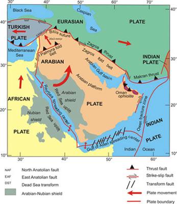
2 I. Physical Geography A. The Middle East includes southwestern Asia and North Africa. 1. The name is Eurocentric. Middle East is a term used to describe the location of this region in relation to Europe. The term for this region is still widely used today. B. High amount of geologic activity: 3 tectonic plates converge so earthquakes are common. 1. Folding of sedimentary rocks has created vast deposits of oil and natural gas. 2. The Red Sea is a divergent zone and is getting wider. The rift splits in two creating the Sinai Peninsula and a valley for the Jordan River and the Dead Sea (lowest elevation on Earth at 1,312 ft. below sea level).
3


4 C. Oil Resources are abundant in the region % of the world s crude oil supplies are found in Saudi Arabia.

5 D. Climate - Arid climate dominates with little to no rain yearround in many areas. 1. Prior to 5000 years this area was not as arid as it is today. People moved to the river valleys where the earliest human civilizations began (Nile River; Tigris-Euphrates Rivers)

6 The Fertile Crescent
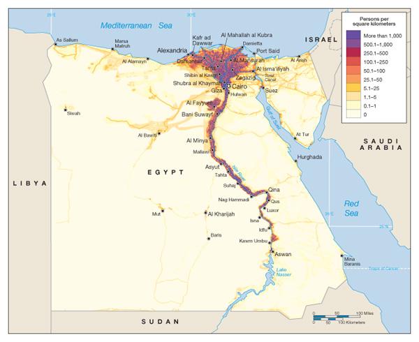
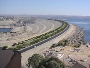
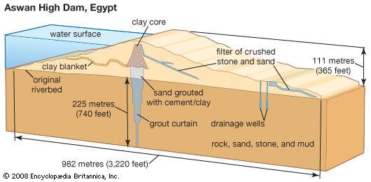
7 E. Water resources are scarce 1. Most rivers are fed from meltwater at their sources in the mountains. Annual flooding in the spring is important for agriculture in the region. 2. Many of these rivers pass through more than one country, so conflict can arise when rivers are polluted or dammed upriver. a. Development of the upper Tigris & Euphrates Rivers in Turkey has caused political issues with Iraq. 3. The Nile River provides water for drinking & agriculture for the 82 million people of Egypt. The physiological density of Egypt is 3,053 people/square mile of arable land. Almost all of Egypt s population lives along the Nile River. a. The Aswan High Dam was built along the first cataract of the Nile from It created Lake Nassar behind it. Despite increasing crop yields, Egypt is still not self-sufficient agriculturally due more subsistence farming rather than commercial farming which is more efficient.
8
9 The Aswan High Dam A. The dam was built for many reasons: 1. To control the yearly spring flooding when high-waters wiped out crops. 2. To deal with droughts in low-water years. B. The dam through helping to control flooding and droughts, helped increase agricultural production downstream. However, the dam also blocks the very fertile silt that is deposited after flooding. This has caused an increase in artificial fertilizer use and because the Nile Delta is not being replenished with new soil as it is also being eroded, the delta is sinking.
10 The Aswan High Dam C. The lake has caused the water table in the area to rise closer to the surface causing drainage issues where crops are irrigated. This has caused swamplands to form increasing the incidence of malaria. D. The building of the dam created Lake Nassar causing many people to be forcibly relocated and flooding archaeological sites. Some had to be relocated (Temple of Abu Simbel).
11

12 The Temple of Abu Simbel at Lake Nassar Moving the Temple
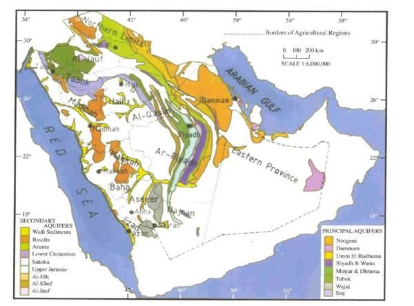
13 E. Water Water resources are scarce 1. Underground aquifers (nonrenewable and very far below ground); major issues include: a. Polluted agricultural chemical runoff (fertilizers & pesticides) b. Aquifers are replenished by rainfall that is less than 10 inches annually. Removal of groundwater by a growing population is depleting it faster than it can be replenished. c. The rock layers that holds the water is often contaminated by crude oil. d. Drilling wells is very expensive because the groundwater is can be as far 6000 feet below the surface in some areas. 2. Desalinization plants to remove salt from water along the coasts
14
15 F. Major Bodies of Water 1. Gulfs Persian, Aden, Aqaba, Oman 2. Seas Mediterranean, Red, and Dead Sea a. The Mediterranean and Red Seas are connected by the Suez Canal a major construction venture by the occupying British Empire from G. Major Landforms 1. Atlas Mountains (Morocco & Algeria); Zagros Mountains (Iran) 2. Sahara Desert (includes smaller deserts such as the Nubian, & Libyan); Rub al-khali (Saudi Arabia) 3. Peninsulas a. Anatolian Turkey b. Arabian Saudi Arabia, Yemen, Oman, Kuwait, U.A.E., Qatar c. Sinai part of Egypt
16 H. Agriculture due to the increasing population in the Middle East food sources are important and have been for the thousands of years this land has been inhabited. 1. Two of the earliest human civilizations arose in this region: Egyptian along the Nile River valley and Sumerian along the Tigris-Euphrates Rivers in present day Iraq (Mesopotamia). 2. The Neolithic Revolution arose in this region specifically the area known as the Fertile Crescent. This area stretched from Iraq into Syria, Lebanon, Turkey, and Israel. a. The Neolithic Revolution began in this area about 10,000 years ago with experimentation in growing wheat & barley as well as the domestication of animals such as cattle, sheep, & goats. b. This caused humans who were mainly nomadic (followed herds of animals from winter to summer feeding grounds) to create farming settlements where water was available later becoming the first cities and civilizations.
17 II. Population & Demographics A. The population of the Middle East is approximately 500 million and growing. 1. Migration within the Middle East is mainly rural to urban within individual countries and from one country to another such as movement on the Arabian peninsula from poorer countries (such as Yemen, the poorest) to wealthy countries (such as the U.A.E.) 2. Immigration to the Middle East is mainly from countries in South & Southeast Asia. Many of these people are not treated well depending on which country they migrate to. 3. Emigration out of the Middle East to countries in the West (mainly Europe) are mostly younger people who go to universities in the West with visas and apply for citizenship to stay. This is causing brain drain in the Middle East. There are better job opportunities in the West for the younger generations.
18 II. Population & Demographics B. Urban Patterns 1. There are issues with rural to urban migration placing stress on the infrastructure of existing cities that are very old such as those in the Fertile Crescent. Many modern cities have a central old city called a medina. a. medina the walled urban core of an Islamic city, dominated by a central mosque (named after the sacred city of Medina in Saudi Arabia) 2. These city cores include souks, commercial markets, and attract tourists seeking authentic Islamic culture. Prestigious craft workers are usually found within the walls of the medina. 3. Residential areas of cities are usually drawn into quarters based on religion to separate Muslims, Jews, and Christians.
19
UNIT 5 PHYSICAL GEOGRAPHY SG 1 - PART I
 UNIT 5 PHYSICAL GEOGRAPHY SG 1 - PART I Africa is HUGE! I. LANDFORMS A. Plateaus - an area of relatively level high ground. 1. Africa s interior is dominated by series of plateaus and elevated basins such
STUDY GUIDE. The Land. Chapter 17, Section 1. There are frequent earthquakes in the region. Petroleum is a major export in the region.
 For use with textbook pages 421 426. The Land Terms to Know alluvial soil A rich soil made up of sand and mud deposited by flowing water (page 423) wadi A streambed that remains dry until a heavy rain
Middle East Part I Notes
 Middle East Part I Notes What do we already know about the Middle East? What do we already know about the Middle East? Pre-Test 1. T/F- The U.S. is currently fighting a war in the Middle East. 2. Which
North Africa and Southwest Asia. Economic Geography
 North Africa and Southwest Asia Economic Geography Natural Resources Oil is the major resource in this region. Many countries in this region are members of OPEC (Organization of Petroleum Exporting Countries).
Chapter 17. North Africa, Southwest Asia and Central Asia
 Chapter 17 North Africa, Southwest Asia and Central Asia Chapter Objectives Describe the major landforms and natural resources of North Africa, Southwest Asia, and Central Asia. Discuss the climate and
North Africa. Chapter 25. Chapter 25, Section
 Chapter 25, Section World Geography Chapter 25 North Africa Copyright 2003 by Pearson Education, Inc., publishing as Prentice Hall, Upper Saddle River, NJ. All rights reserved. Chapter 25, Section World
Chapter 16 ~ Eastern Mediterranean
 Chapter 16 ~ Eastern Mediterranean Physical Geography of the Eastern Mediterranean Landforms This area is known as the Levant and includes Syria, Jordan, Lebanon, Israel, and the Palestinian territories.
Chapter 16 ~ Eastern Mediterranean
 Chapter 16 ~ Eastern Mediterranean Physical Geography of the Eastern Mediterranean Landforms This area is known as the Levant and includes Syria, Jordan, Lebanon, Israel, and the Palestinian territories.
Ancient Egypt. Life Along the Nile River
 Ancient Egypt Life Along the Nile River 2018 Geography How Does Geography affect the way that people live? Geography- Where in the World? You are Here Streetsboro, Ohio United States of America Geography-
Just how big is Africa?
 The United States China India The United Kingdom Portugal Spain France Belgium Germany The Netherlands Switzerland Italy Eastern Europe Japan 11.7 million sq. miles Just how big is Africa? Chapter 18 Section
Chapter 7 Geography and the Early Settlement of Egypt, Kush, and Canaan
 Chapter 7 Geography and the Early Settlement of Egypt, Kush, and Canaan How did geography affect early settlement in Egypt, Kush, and Canaan? Section 7.1 - Introduction RF/NASA//Corbis This satellite photograph
Chapter 7: The Geography and Settlement of Egypt, Kush, and Canaan
 Chapter 7: The Geography and Settlement of Egypt, Kush, and Canaan Learning Target: I can explain how geography affected early settlement in Egypt, Kush, and Canaan. Ancient Egypt and the Middle East Can
Ancient Egypt and the Near East
 *O*»f ' i ft Ancient Egypt and the Near East Chapter 7 Chapter 8 Chapter 9 Geography and the Early Settlement of Egypt, Kush, and Canaan The Ancient Egyptian P h a r a o h s Daily Life in Ancient Egypt
6th Grade Social Studies Chapter 7: The Geography and Early Settlement of Egypt, Kush and Canaan
 I. Introduction (7.1) A. Egyptians settled along the Nile River, in the NE corner of Africa B. civilization lasted from around 3100 B.C. to 350 C. E. C. Kushites settled to the south of Egypt, along the
Chapter 7. Geography and the Early Settlement of Egypt, Kush, and Canaan
 Chapter 7 Geography and the Early Settlement of Egypt, Kush, and Canaan Chapter 7 Geography and the Early Settlement of Egypt, Kush, and Canaan How did geography affect early in Egypt Kush, and Canaan?
Unit 1: Physical Geography Notes
 - How has the physical world impacted settlement patterns? o Major factors in the decision-making process of o Before the boom controlling the physical environment was not possible on a large scale - Physical
Annex III: Statistics
 Annex III: Statistics Table A.3.1 Physical characteristics of Arab countries Country Area, 2011 (thousand square kilometres) Length of coast, 2005 (kilometres) Rainfall, 2002 (millimetres per year) Total
Ancient Egypt. Land of the Pharaohs
 Ancient Egypt Land of the Pharaohs CHAPTER 4 EGYPT SECTION 1: GEOGRAPHY AND EARLY EGYPT BIG IDEA The water, fertile soils, and protected setting of the Nile Valley allowed a great civilization to arise
Essential Standards: WH.H.2 Analyze ancient civilization and empires in terms of their development, growth and lasting impact.
 Unit: Ancient Civilizations Topic: The Nile River Valley Essential Standards: WH.H.2 Analyze ancient civilization and empires in terms of their development, growth and lasting impact. Clarifying Objectives:
Chapter 4. Ancient Egypt and Kush Section 1: Geography & Ancient Egypt
 Chapter 4 Ancient Egypt and Kush Section 1: Geography & Ancient Egypt The gift of the nile Geography played a key role in the development of the Egyptian civilization. The Nile River brought life to Egypt.
PHYSICAL GEOGRAPHY. Unit 1
 PHYSICAL GEOGRAPHY Unit 1 HOW HAS THE PHYSICAL WORLD IMPACTED SETTLEMENT PATTERNS? Major factor in the decision-making process of settlers Before the technological boom controlling the physical environment
1: The Nile River Valley
 1: The Nile River Valley In Nubia and Egypt, the Nile flows through the Sahara, a vast desert that stretches across most of northern Africa. Before reaching Egypt, the river in ancient times roared through
Module 1 Educator s Guide: Representative Discussion Points Investigation 3
 Module 1 Educator s Guide: Representative Discussion Points Investigation 3 Ethiopia and Eritrea Our combined population is 59,578,171 people. We have just emerged from a long period of civil war and famine.
Rivers. Highlights of some of the World s Most Famous Rivers!
 Rivers Highlights of some of the World s Most Famous Rivers! Directions This Power Point presentation contains information about some of the most famous rivers in the world! Students should use this presentation
Babylon. Ancient Cities by the River Lesson 5 page 1 of 6. Code of Hammurabi monument. E u p h. T i g r i s. r a t e s. Babylon, Mesopotamia
 Ancient Cities by the iver Lesson 5 page 1 of 6 1700s BCE, and established the importance of the city for the region He was responsible for a code of laws/decrees to reestablish justice in the land His
The Nile is the world s longest river. It is 4,160 miles long. It flows north and empties into the Mediterranean Sea
 The Nile is the world s longest river. It is 4,160 miles long It flows north and empties into the Mediterranean Sea Lower Egypt is at the Nile s mouth near the Mediterranean Sea. It is in Northern Egypt
THE GEOGRAPHY OF THE NILE. Section 1
 THE GEOGRAPHY OF THE NILE Section 1 The Nile River is the world s longest river. It flows north from its sources in East Africa to the Mediterranean Sea for more than 4,000 miles. THE COURSE OF THE NILE
Brain Wrinkles. Africa: The impact of location, climate, & physical characteristics on where people live, the type of work they do, & how they travel
 Africa: The impact of location, climate, & physical characteristics on where people live, the type of work they do, & how they travel STANDARDS: SS7G3 The student will explain the impact of location, climate,
Egypt (The Nile River Valley)
") 2 nd Quarter Civilizations Mesopotamia (The Tigris & Euphrates) Egypt (The Nile River Valley) India (The Indus River) China (The Yellow River) 1 River Valley Civilizations 2 3 2 nd Quarter 2017 ISN Table
2 nd Quarter Civilizations Mesopotamia (The Tigris & Euphrates) Egypt (The Nile River Valley) India (The Indus River) China (The Yellow River) 1 River Valley Civilizations 2 3 2 nd Quarter 2017 ISN Table
A: Pre-reading Vocabulary
 - 1 - In this text you are going to read about Egypt and the Egyptian people. There are some words in this text that you won t see very often when you are reading but are important for this text. These
the basic principle of justice in Hammurabi s Code ( an eye for an eye ). (H, C, E)
. (H, C, E)") SEPTEMBER OCTOBER NOVEMBER HUMAN ORIGINS IN AFRICA THROUGH THE NEOLITHIC AGE 7.1 Describe the great climatic and environmental changes that shaped the earth and eventually permitted the growth of human
SEPTEMBER OCTOBER NOVEMBER HUMAN ORIGINS IN AFRICA THROUGH THE NEOLITHIC AGE 7.1 Describe the great climatic and environmental changes that shaped the earth and eventually permitted the growth of human
Egypt. Egypt A Reading A Z Level U Leveled Book Word Count: 1,288 LEVELED BOOK U
 A Reading A Z Level U Leveled Book Word Count: 1,288 Discussion Questions Analyze: Why is the Nile River important to the people of? Analyze: How does s ancient history affect the country today? LEVELED
HIST-WG Singleton WG 2nd 6 Weeks' Exam
 HIST-WG Singleton WG 2nd 6 Weeks' Exam [Exam ID:2NDJK9] Scan Number:253 1 In the Asian region, there have been great strides in agricultural advancements and technology which have enabled greater food
How to play. The center aisle divides our class into 2 teams. Team members are NOT allowed to help their teammate when they are asked a question.
 Floaters & Sinkers How to play The center aisle divides our class into 2 teams. Each person will be responsible for answering a question for every round played. Team members are NOT allowed to help their
So130 Week 02 #13-63 #13. What is the Fertile Crescent a reference to?
 Week 02 STUDY GUIDE QUESTIONS #13-63 1 #13 What is the Fertile Crescent a reference to? A Band of Land where conditions favored the establishment of early agricultural settlements. 2 1 The Fertile Crescent
Ancient River Valley Civilizations Egypt
 Ancient River Valley Civilizations Egypt Geography of Egypt The first civilization in Africa developed along the Nile River, in a place called Egypt. These humans were at first nomadic, also known as hunter-gatherers.
Chapter 4 : Ancient Egypt and Kush
 Chapter 4 : Ancient Egypt and Kush Chapter 4 Section 1 Geography and Ancient Egypt The Nile River is the most important thing in Egypt. The Nile is the longest river in the world. It stretches about 4000
Egypt. Egypt A Reading A Z Level X Leveled Book Word Count: 1,417 LEVELED BOOK X
 A Reading A Z Level X Leveled Book Word Count: 1,417 Discussion Questions Evaluate: How has the Nile River affected where people live in? Analyze: How have conflicts in s history shaped its people and
Egypt is located in northeastern Africa and southwestern Asia. It covers 385,229 square
 Egypt Location Egypt is located in northeastern Africa and southwestern Asia. It covers 385,229 square miles. Egypt lies on the coordinates 27 N, 30 E. Libya lies on Egypt s west border, Sudan on its south,
Ancient Egypt: an Overview
 Ancient Egypt: an Overview Timeline Old Kingdom Middle Kingdom 2650 BC 2134 BC 2125 BC 1550 BC New Kingdom 1550 BC 1295 BC http://www.thebanmappingproject.com/resources/timeline.html 1 Three Kingdoms of
Key Geographic Features
 DUE 12/6/18 Name: Lesson One: Egypt Geography 6.15 On a historical map locate the Mediterranean and Red Seas, the Nile River and Delta, and the areas of ancient Nubia and Egypt. Identify the locations
Vocabulary Words. predict inundation deity afterlife. mummy cataract nation-state dynasty
 The Gift of Nile Vocabulary Words predict inundation deity afterlife mummy cataract nation-state dynasty Predict Predict: To tell ahead of time what will happen. Inundation Inundation; Annual flooding
Name Class Date. Ancient Egypt and Kush Section 1
 Name Class Date Ancient Egypt and Kush Section 1 MAIN IDEAS 1. Egypt was called the gift of the Nile because the Nile River gave life to the desert. 2. Civilization developed along the Nile after people
absolute building land water
 Site and Situation What makes a city great? Why are some cities better than others? Cities developed for a variety of reasons. Site and situation are important geographic concepts when studying the reasons
Mexico. Chapter 10. Chapter 10, Section
 Chapter 10, Section World Geography Chapter 10 Mexico Copyright 2003 by Pearson Education, Inc., publishing as Prentice Hall, Upper Saddle River, NJ. All rights reserved. Chapter 10, Section World Geography
Ancient Egypt, Kush, and Israel
 G e o g r a p h y C h a l l e n g e Ancient Egypt, Kush, and Israel EUROPE ASIA ATLANTIC OCEAN AFRICA INDIAN OCEAN ATLANTIC OCEAN N W E S Ancient Egypt, about 1500 B.C.E. Kingdom of Kush, about 1500 B.C.E.
Geography of Ancient Greece Summary Sheet for Use in Assessment
 Geography of Ancient Greece Summary Sheet for Use in Assessment 1. At the same time that the Shang dynasty was ruling much of the Huang He River valley and the Egyptian pharaohs were building the New Kingdom
How the Nile River Led to Civilization in Ancient Egypt
 How the Nile River Led to Civilization in Ancient Egypt By USHistory.org, adapted by Newsela staff on 03.07.17 Word Count 786 Level 950L TOP: This photo, taken around 1915, shows the flooding of the Nile
Unit 6 vocabulary. Serengeti Plain
 basin Nile River rift valley Mount Kilimanjaro escarpment Sahara aquifer oasis Serengeti Plain canopy Niger delta Sahel the world s longest river, flowing more than 4,000 miles through Uganda and Sudan
STUDY GUIDE. The Land. Chapter 20, Section 1. The Land of Africa South of the Sahara. Landforms Water Systems Natural Resources.
 For use with textbook pages 499 504. The Land Terms to Know escarpment A steep, often jagged slope or cliff (page 500) cataract A towering waterfall (page 500) rift valley A large crack in the earth s
The Nile Valley For use with pages 38 46
 READING ESSENTIALS AND STUDY GUIDE 2-1 The Nile Valley For use with pages 38 46 Key Terms cataract: spot of rapid waters in a river (page 39) delta: area of fertile soil at a river s end (page 39) papyrus:
Ancient Egypt, Kush, and Israel
 500 1,000 miles T ER ES D N YA LIB 1 Geography and the Early Settlement of Egypt, Kush, and Canaan AFRICA NUBIAN DESERT ed 0 500 1,000 kilometers Sinusoidal (Sanson-Flamsteed) Projection S E ARABIAN PENINSULA
The Geography of the Middle East
 The Geography of the Middle East Unit 1 Focus The focus of this unit is how physical and cultural geography shape the environment, nations, and people of the Middle East The Middle East is also called
Physical characteristics and biomes:
 Physical characteristics and biomes: Sahel region, bordering Sahara Characteristics Area suffers from lack of rainfall, over grazing, which causes loss of vegetation and loss of inhabitable areas causing
Welcome to Egypt! But before we talk about anything else, we have to talk about the most important thing in Egypt. (other than me) the Nile River.
 the Nile River.") Welcome to Egypt! Hi! My name is Sphinxy, your tour guide through the gift of the Nile. I ll show you all you need to know about the ancient kingdom of Egypt. (other than me) the Nile River. But before
Welcome to Egypt! Hi! My name is Sphinxy, your tour guide through the gift of the Nile. I ll show you all you need to know about the ancient kingdom of Egypt. (other than me) the Nile River. But before
STUDENTS WILL BE ABLE TO IDENTIFY THE MAJOR GEOGRAPHIC FEATURES OF EGYPT AND THE SURROUNDING REGION
 SOUTHWESTERN CHRISTIAN SCHOOL WORLD HISTORY STUDY GUIDE # 7 : ANCIENT EGYPT 3,000 BC 200 BC LEARNING OBJECTIVES STUDENTS WILL BE ABLE TO IDENTIFY THE MAJOR GEOGRAPHIC FEATURES OF EGYPT AND THE SURROUNDING
Africa s. Presentation, Graphic Organizers, & Activities
 Africa s Presentation, Graphic Organizers, & Activities STANDARDS: SS7G1 Locate selected features of Africa. a. Locate on a world and regional political-physical map: Sahara, Sahel, savanna, tropical rain
Appendix A Geographic and Geologic Terms Connected With Egypt
 Appendix A Geographic and Geologic Terms Connected With Egypt Egypt Official name is the Arab Republic of Egypt. Total area is 1,002,450 km 2, which makes Egypt the 29th largest country in the world. Only
Passwords. Social Studies Vocabulary. Ancient Civilizations
 Passwords Social Studies Vocabulary Ancient Civilizations To the Student What is an epic? Is it bad if a tyrant takes over a country? What does an astronomer do? Passwords: Social Studies Vocabulary will
"The Nile River Valley"
 "The Nile River Valley" I. The Nile River Valley A. Geography of the Nile River Valley 1. flows for 4,000 miles a. from Central to the Mediterranean Sea b. sources include the Nile and the Nile 2. isolated
SS7G1 The student will locate selected features of Africa.
 Standards SS7G1 The student will locate selected features of Africa. a. Locate on a world and regional political-physical map: the Sahara, Sahel, savanna, tropical rain forest, Congo River, Niger River,
UNIT 5 AFRICA PHYSICAL GEOGRAPHY SG 1 - PART II
 UNIT 5 AFRICA PHYSICAL GEOGRAPHY SG 1 - PART II III. CLIMATE & VEGETATION A. The four main climate zones are tropical wet, tropical wet/dry (split into monsoon & savanna), semiarid, and arid. Other climate
Lesson 1: The Lifeline of the Nile
 Lesson 1 Summary Lesson 1: The Lifeline of the Nile Use with pages 78 81. Vocabulary delta a triangular-shaped area of soil at the mouth of a river silt a mixture of soil and small rocks papyrus a plant
Study Guide Chapter 5 Ancient Egypt and Kush
 Study Guide Chapter 5 Ancient Egypt and Kush 1) cataract: a waterfall or rapids in a river Key Vocabulary Terms: 9) bureaucrat: a government official 2) delta: a fan shaped are of silt near where a river
Chapter 21: EAST AFRICA
 Chapter 21: EAST AFRICA Physical Geography of East Africa Landforms East Africa is a diverse landscape of different plains, volcanic mountains, and plateaus cut by a large valley and marked by many rivers
The Ancient Egyptians
 The Ancient Egyptians Geography of Ancient Egypt Religion In Ancient Egypt Ancient Egyptian Society The Geography of Ancient Egypt Nile River Giver of Life Longest river in the world @ 4200 miles Protected
COUNTRY CASE STUDIES: OVERVIEW
 APPENDIX C: COUNTRY CASE STUDIES: OVERVIEW The countries selected as cases for this evaluation include some of the Bank Group s oldest (Brazil and India) and largest clients in terms of both territory
Egypt and the Nile River Valley System. SC Standards 6-1.3, 1.4, 1.5
 Egypt and the Nile River Valley System SC Standards 6-1.3, 1.4, 1.5 Where is Egypt? Egypt is on the continent of Africa. The River Nile runs through Egypt The capital of Egypt is Cairo Where is Egypt?
Development of African Agriculture
 Development of African Agriculture Sahara desert originally highly fertile region Western Sudan region nomadic herders, c. 9000 BCE Domestication of cattle c. 7500 BCE Later, cultivation of sorghum, yams,
Break the Code Egyptian Civilization
 Name: Class: World History Date:. Directions: Use this code to help you complete each sentence. Break the Code Egyptian Civilization A = 1 B = 2 C = 3 D = 4 E = 5 F = 6 G = 7 H = 8 I = 9 J = 10 K = 11
Chapter 20. The Physical Geography of Africa South of the Sahara
 Chapter 20 The Physical Geography of Africa South of the Sahara Chapter Objectives Identify the major landforms, water systems, and natural resources of Africa south of the Sahara. Describe the relationship
All of this week s homework is intended to help you get to know more about the country of Sudan, where Kek is from in Home of the Brave.
 Name: Week 7 Homework All of this week s homework is intended to help you get to know more about the country of Sudan, where Kek is from in Home of the Brave. On the map above, do the following things:
The River Nile. Use an atlas to draw on the River Nile. Colour the countries that use the River Nile.
 The River Nile Use an atlas to draw on the River Nile. Colour the countries that use the River Nile. http://alabamamaps.ua.edu/contemporarymaps/world/africa/index.html The start of the River Nile is in
CHAPTER 12. South America. Section 1: Natural Environments Section 2: History and Culture Section 3: South America Today. HOLT World Geography
 CHAPTER 12 South America Section 1: Natural Environments Section 2: History and Culture Section 3: South America 1 Section 1 Natural Environments Objectives: What are the major landforms and rivers of
Human Geography Summer Assignment
 Human Geography Summer Assignment Introduction: Human Geography is, in the most basic sense, the study of why people do things where they do and how increased interaction between people in different locations
Mediterranean Sea Persian Gulf Red Sea Tigris River Euphrates River Sumer Fertile Crescent
 GEOGRAPHY MESOPOTAMIA MAP Mediterranean Sea Persian Gulf Red Sea Tigris River Euphrates River Sumer Fertile Crescent ACHIEVEMENT INTELLECT RELIGION POLITICS SOCIETY ECONOMY N Fertile Crescent - lots of
Egyptian Civilization (3100 B.C-332 B.C.)
") Egyptian Civilization (3100 B.C-332 B.C.) Ancient Egypt -a land of mysteries. No other civilization has so captured the imagination of scholars and public in general. Mystery surrounds its origins, its
Egyptian Civilization (3100 B.C-332 B.C.) Ancient Egypt -a land of mysteries. No other civilization has so captured the imagination of scholars and public in general. Mystery surrounds its origins, its
Geography (cont) Sorghum, rice, millet, rice, wheat and corn grown on savannahs. Not just one big plain though mountainous and swampy areas too
 Sorghum, rice, millet, rice, wheat and corn grown on savannahs. Not just one big plain though mountainous and swampy areas too") Geography & Society in Africa: 500 BCE-900 CE Geography Around 5000 miles wide and long Various climates, jungles, snow-capped mountains, deserts and rain-soaked areas. 40% desert - largely uninhabitable
Geography & Society in Africa: 500 BCE-900 CE Geography Around 5000 miles wide and long Various climates, jungles, snow-capped mountains, deserts and rain-soaked areas. 40% desert - largely uninhabitable
Social Studies: The World
 Social Studies: The World What is the name of the continent that is labeled #1 on the map? North America What is the name of the continent that is labeled #2 on the map? South America What is the name
SUPPLY CHAIN IMPACTS OF THE DIPLOMATIC CRISIS IN THE MIDDLE EAST
 SUPPLY CHAIN IMPACTS OF THE DIPLOMATIC CRISIS IN THE MIDDLE EAST DHL RESILIENCE360 INTELLIGENCE BRIEF June 2017 dhl.com/resilience360 resilience360@dhl.com 2 DHL RESILIENCE 360 INTELLIGENCE BRIEF EXECUTIVE
Mediterranean Europe
 Chapter 17, Section World Geography Chapter 17 Mediterranean Europe Copyright 2003 by Pearson Education, Inc., publishing as Prentice Hall, Upper Saddle River, NJ. All rights reserved. Chapter 17, Section
GEOGRAPHY AND HISTORY
 GEOGRAPHY AND HISTORY YEAR 1, PART 1 www.vicensvives.es Contents 01 Our planet Earth 02 The representation of the Earth: maps 03 The Earth s relief 04 Rivers and seas 05 Weather and climate 06 Climates
BRITANNICA STUDENT ENCYCLOPEDIA. Africa is the world s second largest continent. More than 50 countries make up
 JOBNAME: No Job Name PAGE: 33 SESS: 682 OUTPUT: Thu Aug 31 10:43:41 2006 38 Africa BRITANNICA STUDENT ENCYCLOPEDIA Africa Africa is the world s second largest continent. More than 50 countries make up
WATER MAY BE NEXT FLASHPOINT IN MIDEAST (Senate - March 26, 1992) [Page: S4417] [Page: S4416]
![WATER MAY BE NEXT FLASHPOINT IN MIDEAST (Senate - March 26, 1992) [Page: S4417] [Page: S4416]](/thumbs/78/78275515.jpg "WATER MAY BE NEXT FLASHPOINT IN MIDEAST (Senate - March 26, 1992) [Page: S4417] [Page: S4416]") 1 of 6 5/13/2008 12:22 PM WATER MAY BE NEXT FLASHPOINT IN MIDEAST (Senate - March 26, 1992) [Begin insert] [Page: S4417] [Page: S4416] Mr. SIMON. Mr. President, one of the policy areas where we have paid
1 of 6 5/13/2008 12:22 PM WATER MAY BE NEXT FLASHPOINT IN MIDEAST (Senate - March 26, 1992) [Begin insert] [Page: S4417] [Page: S4416] Mr. SIMON. Mr. President, one of the policy areas where we have paid
The Northern Tropics
 The Northern Tropics The Guianas Countries Guyana, Suriname, French Guyana Culture reflects colonial history Official Languages Guyana English Suriname Dutch French Guyana - French Religions Suriname and
COMCEC STRATEGY. For Building an Interdependent Islamic World. COMCEC TRANSPORT and COMMUNICATIONS OUTLOOK 2018
 COMCEC TRANSPORT and COMMUNICATIONS OUTLOOK 2018 Transport and Communications Working Group 12 th Meeting October 11th, 2018 Ankara, Turkey OUTLINE Importance of Transport and Communications for COMCEC
 Unifying Egypt (p. 85) Ancient Egypt was divided into two parts Upper Egypt and Lower Egypt. One famous legend tells of the king of Upper Egypt, whose name was Menes. He defeated the king of Lower Egypt
Introduction to Africa
 Introduction to Africa Did you know? Africa has more countries than any other continent. The Sahara is a desert that is the size of the U.S. It s the world's largest desert. Most of the world s gold and
ì<(sk$m)=bdicij< +^-Ä-U-Ä-U
=bdicij< +^-Ä-U-Ä-U") Genre Comprehension Skill Text Features Science Content Nonfiction Compare and Contrast Captions Diagrams Rocks and Soil Labels Glossary Scott Foresman Science 3.7 ì
Genre Comprehension Skill Text Features Science Content Nonfiction Compare and Contrast Captions Diagrams Rocks and Soil Labels Glossary Scott Foresman Science 3.7 ì
CST SABE A.A. 2018/19 HISTORY OF ARCHITECTURE_I ANCIENT MESOPOTAMIA. Dr. Manlio MICHIELETTO ARCH1162_HISTORY OF ARCHITECTURE I
 CST SABE A.A. 2018/19 HISTORY OF ARCHITECTURE_I Dr. Manlio MICHIELETTO 1 Column base, Basilique Notre-Dame de la Paix, 1986 2 INDEX 1. Geography 04 05 3 1. Geography 4 1. Geography 5 2. (Pre)History Architecture
Concept Document towards the Dead Sea Basin Biosphere Reserve and World Heritage Listing. This report has been presented to the public and to
 Concept Document towards the Dead Sea Basin Biosphere Reserve and World Heritage Listing. This report has been presented to the public and to political decision makers both regionally and internationally
AFRICAN PHYSICAL GEOGRAPHY
 AFRICAN PHYSICAL GEOGRAPHY Here are some factoids about Africa: world s second largest continent (11,700,000 miles). Home to 52 countries, 1,000 languages, 800 million people. 10% of the world s population
Warm ups *What is unique about the status of Switzerland? *How Austria s history differed from that of Switzerland?
 Warm ups 12.07.2016 *What is unique about the status of Switzerland? *How Austria s history differed from that of Switzerland? Lesson Objective: *describe how Spain differs physically, economically, and
Walk with the nomads: Destinations showcases Middle Eastern adventures
 Walk with the nomads: Destinations showcases Middle Eastern adventures By: Karen Dabrowska City Tourism Twice a year Moroccan Berber nomads take their goats and sheep between the High Atlas to the lower
CH. 1 Europe and Russia: Physical Geography. Section 1 Land and Water p Europe and Russia are part of the world s largest landmass called.
 CH. 1 Europe and Russia: Physical Geography Section 1 Land and Water p.10-16 Europe and Russia are part of the world s largest landmass called. The country of Russia stretches over both continents. About
Daily Lecture and Discussion Notes
 Daily Lecture and Discussion Notes TO THE TEACHER This Daily Lecture and Discussion Notes booklet provides outlines for each section of The World and Its People. Each section begins with a short, highinterest
The Rise of Civilization. Ancient Egypt
 The Rise of Civilization Ancient Egypt Geography The Egyptian civilization was located in Egypt in North Africa. The Egyptian empire was located on the lower deltas of the Nile River. The Egyptians lived
Reading Essentials and Study Guide Student Workbook
 Reading Essentials and Study Guide Student Workbook TO THE STUDENT This Reading Essentials and Study Guide booklet is designed to help you use recognized reading strategies to improve your reading-for-information
Hydrology of Yemen. Dr. Abdulla Noaman
 Hydrology of Yemen Dr. Abdulla Noaman INTRODUCTION Location and General Topography Yemen is located on the south of the Arabian Peninsula, between latitude 12 and 20 north and longitude 41 and 54east,
Chapter 25 Geography and the Settlement of Greece. How did geography influence settlement and way of life in ancient Greece?
 Chapter 25 Geography and the Settlement of Greece 25.1 Introduction How did geography influence settlement and way of life in ancient Greece? Tal Naveh/Shutterstock The ancient Greeks learned to use the