INVENTORY : introduction
|
|
|
- Tiffany Shelton
- 5 years ago
- Views:
Transcription


1 EXISTING SIGNAGE Existing Signage. As is typically the case in existing trail locations, there is often an assortment of forms, colors, materials and applications throughout the system. These include some well-conceived and consistent signage elements evident along Owego s Riverwalk and Otsiningo that emphasize interpretation in the architectural sign forms. Usage and safety information is provided to trail goers along the Vestal Rail Trail. However, there are many portions of the existing trails that have little or no signage to identify trail access or direction or to acquaint visitors with the many heritage, recreational and entertainment offerings. What is more, there is a dizzying array of graphic images projected on the trail or in adjacent neighborhoods and parklands through which the trails pass. Some of the images that can be seen in the vicinity of the trail are shown below. Consequently, there is a tremendous opportunity to create both a uniform identity for the Two Rivers Greenway and standards for orienting and directing visitors. This will serve as a catalyst to forge a more collaborative effort to market the Greenway s many opportunities INVENTORY : introduction


2 DESIGN LANGUAGE INVENTORY design language 8 An important aspect of the Two Rivers Greenway Sign Project is understanding the character of existing trail design features. In order to create a congruent system across the region, an extensive inventory of existing structures, textures, materials and concepts must be catalogued and understood. In our area of Upstate New York materials such as bluestone are easily accessible and widely used as a hardscape element. Shown in these pictures below, bluestone is already incorporated into multiple trail segments including: Owego Riverwalk, Village of Owego Confluence, City of Binghamton Otsiningo, Town of Dickinson Some parts of the trail system already have signage structures in place. Our inventory phase documented the location of many existing sign structures with photographs. Many of the forms, particularly the kiosks, exhibit identity that is compatible with project design criteria. This invites re-use of these structures with new, complementary message panels. Peacemakers Plaza, City of Binghamton Washington Street, City of Binghamton Chenango River Promenade, City of Binghamton Owego Riverwalk, Village of Owego Designers can obtain design clues from existing amenities such as railings and lighting fixtures. Confluence is an excellent example of this. Designed by Haas Landscape Architects, this small park has elements in the 2012 Designers can obtain design clues from existing amenities such as railings and lighting fixtures. Confluence is an excellent example of this. Designed by Haas Landscape Architects, this small park has elements in the railings and lighting fixtures that speak to the Native American Heritage for which this area is known. The forms found within the railings and lighting seen below, are symbolic of Two Rivers in Native American art. Other design language can originate from the feelings one experiences on a particular trail. Depending on the location and setting of a particular segment, planting treatments may differ. Nonetheless, a planting standard can be implemented across the entire trail system that will further enhance the brand of the Two Rivers Greenway. Owego Riverwalk, Village of Owego Confluence, City of Binghamton


3 OWEGO TRAILS Owego Riverwalk ing Locations Owego Creek : Due to its location away from primary travel roads, the boat launch is difficult to locate. No signage is present to direct visitors and users to the facility. Once arriving at the facility there is a wood sign present. Owego Riverwalk: This section of trail is well designed and located within the downtown waterfront of Owego, NY. The trail system features informational kiosks that provide historical interpretations. Along the walk overlooks, signage gives users opportunities to educate themselves on the history of their surroundings. Hickories : Camp signs and trailblazer signage is found on Rte. 17C as well as the connecting bridge from Rte No trail signage is present. Facilities are located onsite and may be a primary location for directional signage. Restroom facilities are located onsite and provide excellent opportunities for orientation and directional signage. Challenging Area: Railroad underpass on north side of Hickories INVENTORY Owego Trail s


4 I-86 TRAIL SEGMENT INVENTORY I Valley View Drive ing Locations 2012 Future Trail Extension: No trail segments are currently built through the I-86 section. A trail is proposed to run through the area that connects from Hickories in Owego to the Vestal Trail extension ending at the Broome/ Tioga County border. Proposed trails in this section will mostly parallel with the Susquehana River s edge connections to be made to Marshland Road in Apalachin. Marshland Road: A trail connection to the facilities along Marshland Road would be advantageous. Two boat launches are located at the west end of the road. The Waterman boat launch is the only access point to get to Hiawatha Island, a recreational destination point for many visitors, and opportunity for interpretation Currently, no trail signage exists. Challenging Area Trail entry from Marshland Road onto Rte. 434.


5 VESTAL TRAILS- west Enjoi G.C. ing Locations Vestal Rail Trail: This 2-mile trail segment is the most utilized section of the current trail system. The trail has 2 trailheads that offer visitors a place to park and unload. The west end of the trail has facility ID signs as well as trail use rules and regulations. Visitors are directed to the trail heads via Trailblazer signage on Rte. 434 and Main Street. Nature Trail: Towards the middle of the paved trail users have the option to use a nature trail that is unpaved. The nature trail offers wetlands and natural areas. A kiosk is present giving rules and regulations as well as information on types of species users may encounter. Future Extension: Future expansion west of the Vestal Rail Trail is expected by The first segment will connect from the west trailhead to the Castle Gardens Senior Living Center about 1.7 miles west. The second phase will go to the County border in Apalachin, NY. Challenge areas: Main Street Crossing to Pumphouse Road. Chugnut Trail on Vestal Avenue. INVENTORY Vestal Trails West


6 VESTAL TRAILS - east INVENTORY Vestal Trails East 12 ing Locations Rte 2012 Vestal Rail Trail: The east end has facility ID signs as well as trail use rules and regulations. The east end offers visitors a pavilion and restroom facilities. The trail is identified by Trailblazer signs on Rte. 434 as well as African Road. Neighboring The northeast portion of the trail is bordered by a neighborhood with a small park providing connection to the trail. Orientation signage should be incorporated at this point to apprise users of the trail system s scope and offerings. Future Extension: Future expansion east of the Vestal Trail will run behind the Vestal Town Square Mall. A narrow strip of land, formerly railroad, is being considered for trail construction. This connection is parallel to Old Vestal Road. This segment will also promote use of Harold Moore and give users access to the Susquehanna River. Challenging Area: Pedestrian safety at Rte. 434 & Airborne Ave intersection. Trail crossing Old Vestal Road.


7 UNION TRIALS - west Enjoi G.C. ing Locations Chugnut Trail: The Chugnut Trail is a 1-mile long segment that runs from the Vestal Avenue bridge to the Boys and Girls Club. Currently the trail has a facility ID sign at either end. On the east end of the trail, a kiosk is present. Future Extension: A western extension of the Chugnut Trail is being considered along the flood wall- providing that regulatory issues can be resolved between the Army Corps of Engineers and the Village of Endicott. The Village hopes to connect the Trail to facilities such as Round Top, Grippen, En-Joie Golf Course and the Tri-Cities Airport. Challenging Area: Vestal Avenue future trail crossing. Union trails connecting into Vestal Trail system across Vestal Ave. bridge. INVENTORY Union Trails West


8 UNION TRAILS- east Union Trails: INVENTORY Union Trails East 14 ing Locations 2012 The Town of Union currently has limited established trail systems in place. Future construction will connect the Chugnut Trail east to the banks of the Susquehanna. The trail has potential to connect into resources such as Argonne located on Argonne Ave. Other existing infrastructure such as the Rte. 17 underpass would create an excellent connection point. This trail system will ultimately connect into Johnson City through William Hill and Boland s.


9 UNIVERSITY TRAIL SEGMENT Rte. 201 Bridge ing Locations Binghamton : Binghamton is a key destination in the trail system with many advantages to its connection to downtown Binghamton. The currently has established trails throughout the campus with a signage system in place at the nature preserve. Future Extension: The future Greenway extension connecting the to downtown is proposed to be completed by This extension will connect along Rte. 434 to the Washington Street Bridge. Some areas of concern are the intersection at Rte. 434 and Vestal Avenue. This intersection is skewed and may be a challenge for pedestrians. The NYSDOT has been considering options by which to safely move trail traffic across Rte These include construction of a bridge, creating an underpass or incorporating a controlled crossing at street level. Challenging Area: Vestal Avenue Rte. 434, pedestrian safety. Entry onto BU Campus. INVENTORY Vestal way Trail


10 CITY OF BINGHAMTON INVENTORY City of Binghamton 16 ing Locations 2012 Confluence : The park designed by Haas Landscape Architects, provides opportunities for directional, orientation and interpretive signage. This site is also a major connection point for bike and walking trails such as the Chenango River Promenade. The Spanish-American War Skirmisher on the north end of the pedestrian bridge is a strategic location for directional, bike route and historical landmark signage. Chenango River Promenade: An established riverwalk, the Promenade already has multiple signage infrastructure systems in place. Currently empty kiosks can be utilized for orientation and interpretive information signs. Cheri Lindsey : Should be considered a trail head destination. Its large parking area and central location to the Greenway Trail provide an excellent opportunity for orientational and directional information signs. Future Extension: Trail connections north to Otsiningo along the Chenango River bank have been explored. Although land is available to complete it, current conflicts with some residential land owners may postpone progress. Challenging Area: Pedestrian crossing at Court Street. Clinton Street Crossing


11 OTSININGO TRIAL SEGMENT ing Locations Otsiningo : This County has an established entry sign and minimal directional signage within the park. A kiosk with a park map is located on the north entrance off of Upper Front Street. A regional Farmer s Market is planned for the former rest-stop within the. This may be an opportunity to provide a minor kiosk. The north entrance should be treated as a trail head. Orientation and Directional signage should be utilized along with rules and regulations. A future extension along Front Street to Otsiningo south entrance is planned. prientation signs will be needed near the south entrance. Signage within the park should be the responsibility of the County s Department. No signage currently exists to direct traffic exiting I-81 to the park and Greenway system. The wayfinding sign system should commence as early as the I-81 off ramps. Challenging Areas Upper Front Street bike route intersection into Otsiningo, north entrance Front Street/ Bevier Street intersection at Otsiningo, south entrance. INVENTORY Otsiningo park


 in both directions.")


12 CHENANGO BRIDGE INVENTORY Chenango Bridge 18 ing Locations 2012 Rte 12A and Ride: This destination could become a significant trailhead. Its generous parking facilities and northern suburban location can provide an important access point for trail users. Existing signage for the & Ride is present and begins on Chenango Street (Rte. 12A) in both directions. Future Expansion: Trails are planned to connect Otsiningo with the & Ride but a completion date is not set. Another extension exists to run down I-88 service road and connect into the Village of Port Dickinson/ Town of Fenton area. Challenging Areas North entrance into Otsiningo. Rte. 12A bridge into Chenango Forks.


13 VILLAGE OF PORT DICKINSON/ FENTON ing Locations Village of Port Dickinson Jeanne & John D. Wilfley Community : Facility identification and park signage is present. Multiple signage elements could be consolidated at the park entrance and to reduce confusion. No trailblazer signage is present to direct traffic to the park along Chenango Street. The park offers many amenities such as recreational fields walking paths and access to the Chenango River via boat launch. The is also home to the Angel of Hope Memorial. Future Expansion: Furthering the trail north has been looked at in the past. However the character of the land it would pass through, and private ownership makes it unlikely. Therefore, on-road connection along the service road is preffered. Challenging Area Pedestrian safety along Rte. 12A bridge into Chenango Bridge. Entry into Village of Port Dickinson INVENTORY Port Dickinson/ Fenton

14 TOWN OF CONKLIN INVENTORY towon of Conklin 20 ing Locations Sullivan, Schnurbusch, Conklin 2012 Currently Conklin offers on-road bike lanes that begin in the City of Binghamton and extend into the Town. Conklin recently added a new park/ boat launch called Sullivan. The is located on Conklin Rd. north of the former Conklin Sports facility, and was formerly a residential lot that was flooded in There are currently no proposed trail segments for the Two Rivers Greenway in the Town of Conklin. However, there is one trail project to be built in the next 2-3 years that is in the Broome Corporate and will connect to Schnurbusch, which is the the eastern extent of the Two Rivers Greenway.
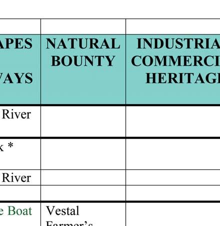
15 DESTINATIONS All except Vestal ORIENTATION AND DIRECTIONAL POINTS OF INTEREST MUNICIPALITY LANDSCAPES & WATERWAYS NATURAL BOUNTY City of Binghamton MacArthur Northside Farmer s Market Recreation Binghamton Farmer s INDUSTRIAL/ COMMERCIAL HERITAGE Railroad Terminal Historic District Binghamton Railway Company Complex Market Sandy Beach Center for Technology & Innovation HISTORICAL/ HERITAGE SITES/ VISITOR CTRS E ARTS & ARCHITECTURAL GEMS TRANSPORTATION CTRS/ MUNICIPAL BLDGS Roberson Museum Artists Row South Washington Street Parabolic Bridge Binghamton Visitor Center Clinton Street Antique Row The Bundy Arts & Victorian Museum Riverwalk Fine Art Gallery Cheri Lindsey Christ Church The Art Mission & Theatre Confluence Court Street Historic Forum Theater District Chenango River State Street/Henry Tri-Cities Opera Promenade St. Historic District Martin Luther Abel Bennett Tract Binghamton King, Jr. Historic District Philharmonic Promenade Water Street Trail Jonas M. Kilmer House Robert H. Rose House Susquehanna River Phelps Mansion Chenango River ACA Memorial Binghamton City Hall Broome County Courthouse Broome County Transportation Center Broome County Public Library FAMILY/ RECREATION/ ACADEMIC/EDUCATION Binghamton Zoo at Ross Discovery Center of the Southern Tier Broome County Veterans Memorial Arena Link Planetarium at Roberson Museum Ballpark / Stadium Town of Owego Hiawatha Island Waterman Conservation Education Center Hickories INVENTORY of destinations


16 DESTINATIONS INVENTORY of destinations


17 INVENTORY of destinations DESTINATIONS
Beth Lucas, Senior Planner Stephanie Brewer, Planner Broome County Planning May 12 th, 2016
 Beth Lucas, Senior Planner Stephanie Brewer, Planner Broome County Planning May 12 th, 2016 Background Data Collection Trail Mapping Promotional Strategy December 2014 County s natural beauty identified
OR MISSION TRAIL ELEMENTARY
 Leawood: overview OVERLAD PARK 24: p.70 I-LA PARK 32: p.72 TOMAHAWK PARK 23: p.69 31: p.71 GEZER PARK OR MISSIO TRAIL ELEMETARY 22: p.68 W 133rd St W 135th St KASAS CITY MO - other segments Beginning/end
MULTIPLE POLLING PLACES
 MULTIPLE POLLING PLACES CITY OF BINGHAMTON 30 polling places Ely Park Housing, Recreation Center, Glenwood Rd 1 Holy Spirit Recreation Center, 358 Clinton St 2, 5 & 7 Catholic Charities, 290 Front St 3
AGENDA ITEM 5 D WAKULLA ENVIRONMENTAL INSTITUTE (WEI) TRAIL FEASIBILITY STUDY
 TRAIL FEASIBILITY STUDY") March 19, 2018 AGENDA ITEM 5 D WAKULLA ENVIRONMENTAL INSTITUTE (WEI) TRAIL FEASIBILITY STUDY TYPE OF ITEM: Action STATEMENT OF ISSUE The Wakulla Environmental Institute (WEI) Trail is one of several trails
March 19, 2018 AGENDA ITEM 5 D WAKULLA ENVIRONMENTAL INSTITUTE (WEI) TRAIL FEASIBILITY STUDY TYPE OF ITEM: Action STATEMENT OF ISSUE The Wakulla Environmental Institute (WEI) Trail is one of several trails
NEWBORO AND PORTLAND HARBOUR REDVELOPMENT PLANS
 INTRODUCTION The Municipal docks in both Newboro and Portland were transferred to the Township of Rideau Lakes by Parks Canada in 2002. Little has been done to improve the docks physical condition or role
Regional Wayfinding Sign Strategy Thurston County Trails 2017
 Regional Wayfinding Sign Strategy Thurston County Trails 2017 Partners: Members and partnering organizations of the Thurston Thrives Community Design Action Team City of Lacey, City of Olympia, City of
Chapter 6. Trail Design. Trail Design
 Chapter 6 Trail Design Trail Design The trail winds through a region rich in scenic beauty, cultural, and natural history. Volunteer landscape architects working with the Core and Planning Teams, have
Gardner: overview. Santa Fe, Oregon, and California National Historic Trails UNINCORPORATED JOHNSON COUNTY OLATHE UNINCORPORATED JOHNSON COUNTY
 Santa Fe, Oregon, and California ational Historic Trails : overview 99: p.134 100: p.135 GARDER JUCTIO 102: p.137 56: p.126 EDGERTO Burlington orthern Intermodal and Logistics 98: p.133 101: p.136 S Waverly
2004 Broome County, NY Riverbank Clean-Up Results
 2004 Broome County, NY Riverbank Clean-Up Results The event was held Saturday, October 2, 2004 and was organized locally by the Broome County Environmental Management Council. Twenty-two (22) groups worked
IV. RIVER USES & PROJECTS. A. Introduction. B. Initial Waterfront Issues
 IV. RIVER USES & PROJECTS A. Introduction To form a River Vision for southeast Steuben river communities the consultants produced the inventory and analysis chapter of this report. The consultants used
City of Haslett. City of East Lansing. City of East Lansing
 Central Park North (Nancy L. Moore Park) Lake Park North Expansion White Park Expansion #2 White Park Expansion #1 County East East Haslett East East TF87-212 Acquisition $90,000.00 Park. TF08-138 Acquisition
CONTENTS. 1 Introduction Always Moving Forward while Building on the Past A Dynamic Destination... 5
 2010 STRUCTURE PLAN - 2 - CONTENTS 1 Introduction... 5 1.1 Always Moving Forward while Building on the Past... 5 1.2 A Dynamic Destination... 5 2 Map A... 6 Exhibition Place and its Neighbours... 7 3 Demonstration
Hazlet. 1. Overview of Hazlet and Its Waterfront. Hazlet Township. 1.1 Geographic Overview
 Hazlet 1. Overview of Hazlet and Its Waterfront 1.1 Geographic Overview Hazlet Township is located in Monmouth County. The Township has a land area of 5.6 square miles. Situated in the Bayshore region
Figure 1: Little Dry Creek Trail Crossing
 Figure 1: Little Dry Creek Trail Crossing Figure 2: Little Dry Creek Trail Crossing Northwest Rail Environmental Evaluation Temporary Trail Detour Concurrence Form Adams County, Little Dry Creek Trail
Waukee Trailhead Public Art and Amenities Project
 Waukee - Trailhead Public Art and Amenities Project Sponsor Waukee Project Title Waukee Trailhead Public Art and Amenities Project Termini Description ( i.e. Park Avenue to 19th Street) NE Intersection
Premier Office Space For Lease 111 Santa Rosa Avenue, Santa Rosa, CA
 Premier Office Space For Lease 111 Santa Rosa Avenue, Santa Rosa, CA 150 to 13,328 ± Sq. Ft. Available Westamerica Bank Building Downtown Underground and Surface Lot Parking Great Views From Upper Floors
Master Commercial Developer Industry Forum
 Master Commercial Developer Industry Forum Agenda 9:00 am Welcome Phil Washington, Metro CEO Metro Board Director Solis 9:15 am Introductions and Overview of the Event Jenna Hornstock, Executive Officer,
chapter - Hex Highway Touring Route Hamburg to Strausstown Overview
 chapter - 2 Hex Highway Touring Route Hamburg to Strausstown Overview The on-road Hex Highway automobile and bicycle touring route begins on State Street in downtown Hamburg. The route continues west on
1. Overview of Atlantic Highlands and Its Waterfront
 Atlantic Highlands 1. Overview of Atlantic Highlands and Its Waterfront Atlantic Highlands: Satellite Photo by USGS 1.1. Geographical Overview The Borough of Atlantic Highlands is on Sandy Hook Bay. It
Business Item No
 Metropolitan Parks and Open Space Commission Meeting date: February 6, 2018 For the Community Development Committee meeting of February 20, 2018 For the Metropolitan Council meeting of February 28, 2018
Hudson Highlands Fjord Trail Draft Master Plan. April 29, 2015
 Hudson Highlands Fjord Trail Draft Master Plan April 29, 2015 Agenda Route Overview Proposed Segment Results of Community Survey on that Segment Next Steps Municipal Endorsement Environmental Review Implementation
Council Policy Tourist Oriented Destination Signs
 POLICY 373 APPROVED @ City of Kelowna 1435 Water Street Kelowna, BC V1Y 1J4 250 469-8500 kelowna.ca Council Policy Tourist Oriented Destination Signs Contact Department: Civic Operations Traffic Operations
Independence: overview
 : overview Kentucky Ave 8: p.30 SUGAR CREEK SATA FE. OREGO, CALIFORIA 7: p.29 6: p.28 9: p.31 10: p.32 Square, Jackson County Courthouse. Photo: Vireo Trail swale area, Santa Fe Trail. Photo: Vireo HISTORIC
SAN ANTONIO RIVER IMPROVEMENTS PROJECT. August 6, 2008
 SAN ANTONIO RIVER IMPROVEMENTS PROJECT August 6, 2008 1 History of the SA River Improvements 1921 Flood Olmos Dam Complete in 1929 Downtown Flood Relief Projects in 1950 s Dams on the River Channel and
crrv OF DALLAS Memorandum Trinity River Corridor Project Update On Recreation
 Memorandum OATE December 8, 2011 crrv OF DALLAS TO Trinity River Corridor Project Committee Members: Vonciel Jones Hill (Chair) Linda Koop (Vice Chair), Monica Alonzo, Scott Griggs, Angela Hunt, Delia
SAN ANTONIO RIVER IMPROVEMENTS PROJECT. April 27, 2009
 SAN ANTONIO RIVER IMPROVEMENTS PROJECT April 27, 2009 1 Project Limits 2 Project Partners City of San Antonio Provides project funding for project amenities (i.e.. Sidewalks, Landscaping, Lighting, etc.)
WATER PETALUMA TRAIL WATER WAYS PROJECT PORTFOLIO. petalumawaterways.org OVERVIEW
 WATER TRAIL PROJECT PORTFOLIO OVERVIEW Thirteen miles upstream of San Pablo Bay, Petaluma is the northern point on the San Francisco Bay Water Trail, a network of access points throughout the region. Most
3. COLTA / HUGA CONNECTIONS - PRELIMINARY
 9 3. COLTA / HUGA CONNECTIONS - PRELIMINARY 3.1 COLTA The Chain of Lakes Trail Association (COLTA) trail, formerly identified as the Chester Spur Line, was completed and opened for use in June 2011. The
Premier Office Space For Lease 111 Santa Rosa Avenue, Santa Rosa, CA
 Premier Office Space For Lease 111 Santa Rosa Avenue, Santa Rosa, CA 150 to 12,201 ± Sq. Ft. Available Westamerica Bank Building Downtown Underground and Surface Lot Parking Great Views From Upper Floors
PARKWAY INN Vestal, NY 58 Rooms
 PARKWAY INN Vestal, NY 58 Rooms Parkway Inn MTEL Consultants MTEL Consultants Parkway Inn 58 Rooms Vestal, NY EXECUTIVE SUMMARY OPPORTUNITY: This independent property is ideal for an onsite owner operator.
Welcome to the Cross County Trail Public Input Session!
 Welcome to the Cross County Trail Public Input Session! Please sign in on the table below! What are we doing here? Camden County has proposed a bicycle and pedestrian trail spanning across the entire county.
The Baker/Carver Regional Trail is intended to
 Section V Design Guidance The Baker/Carver Regional Trail is intended to safely accommodate 183,000 annual visits, an array of non-motorized uses, a variety of skill levels, and persons with special needs.
A VISION FOR EL MIRAGE
 el mirage A VISION FOR EL MIRAGE OASIS, ARIZONA A thriving desert jewel destination with a strong arts district, high-wage employment parks system joined together by cohesive, multi-use accessible trails
The Recreational Trail along Cushing Park road has been a successful addition to the city
 The Recreational Trail along Cushing Park road has been a successful addition to the city Trails TRAILS, PATHS, ROUTES AND CONNECTORS Citizen input pointed to trails, paths, bike routes, and other non-motorized
CHAPTER 5. Chapter 5 Recreation Element
 CHAPTER 5 Recreation Element Chapter 5 Recreation Element The Recreation Element of the Meyers Area Plan is a supplement to the Recreation Element of the TRPA Regional Plan and the El Dorado County General
SOUTHEAST BOULEVARD Planning Study Washington, DC. Progress Drawings October 6, 2014
 Existing Conditions Site Plan CONGRESSIONAL CEMETERY SOUTHEAST BOULEVARD Planning Study Concept A (formerly A-1) Site Plan Concept A (formerly A-1) Concept A proposes an expansion of the Capitol Hill neighborhood
A CASE FOR COMPLETING THE JORDAN RIVER PARKWAY: A
 A CASE FOR COMPLETING THE JORDAN RIVER PARKWAY: A safe crossing at 9000 South and 850 West Proposed 9000 South Underpass Parkway Timeline Parkway, Trail, and Tourism Facts Blueprint Jordan River 1971 1973
Environment and Natural Resources Trust Fund 2019 Request for Proposals (RFP)
") Environment and Natural Resources Trust Fund 2019 Request for Proposals (RFP) Project Title: Glacial Edge Trail and Downtown Pedestrian Bridge Category: G. Land Acquisition for Habitat and Recreation ENRTF
Environment and Natural Resources Trust Fund 2019 Request for Proposals (RFP) Project Title: Glacial Edge Trail and Downtown Pedestrian Bridge Category: G. Land Acquisition for Habitat and Recreation ENRTF
Classifications, Inventory and Level of Service
 Classifications, Inventory and Level of Service Section 3 Kenmore Park, Recreation and Open Space Plan 1 P a g e Classifications and Inventory Park Classifications Kenmore classifies its parks based upon
Navigating Indiana Road Signage
 Navigating Indiana Road Signage JOE BRUNO Traffic Administration Engineer Indiana Department of Transportation Presentation Overview Background Logo Program (Gas, Food, Lodging, & Camping Services) Attraction
Pier Enhancements April 6, 2017
 Pier Enhancements April 6, 2017 Pier Enhancement Categories Pier Plaza Improvements Contingency Play Elements Destination Differentiators Water Recreation Zone Furniture, Fixtures & Equipment Transportation
Blue River Trail Master Plan JSA to Town Hall June 2004
 Blue River Trail Master Plan JSA to Town Hall June 2004 Prepared for: Silverthorne Town Council Silverthorne SPORT Committee Department of Recreation and Culture Silverthorne Public Works Silverthorne
Public Park System. Township of Derry. Providing natural open space for the recreational use of our residents and guests.
 Township of Derry Public Park System Providing natural open space for the recreational use of our residents and guests. Directory of Recreational Amenities Hershey s Commitment to Recreation Famous candy
Chapter 6: POLICY AND PROCEDURE RECOMMENDATIONS
 Chapter 6 POLICY AND PROCEDURE RECOMMENDATIONS FOR SRRA Below are seven policy elements that should be considered for adoption by the Southwest Regional Recreation Authority of Virginia: 1. Develop strategies
Header i
 Header i 048285014.10 Header Sub Title Body Text here. Body text here. Body text here. Section 1... 1 Executive Summary... 1 Opportunities and Constraints... 3 Overall Opportunities and Constraints Map
Committee Report. Community Development Committee For the Metropolitan Council meeting of April 13, Business Item No.
 Committee Report Business Item No. 2016-48 Community Development Committee For the Metropolitan Council meeting of April 13, 2016 Subject: Harriet Island-South St. Paul Regional Trail Master Plan, Saint
The Falls: A Visitor & Interpretive Center for the Upper Lock
 The Falls: A Visitor & Interpretive Center for the Upper Lock Image courtesy of Northern Spark Surface by Aaron Dysart Illuminate the Lock is a program of Mississippi Park Connection The Falls Initiative
 288.075, F.S. Florida Job Growth Infrastructure Application Response to Question 1A Provide the title and a detailed description of the public infrastructure improvements. The West River Riverwalk
Business Item No XXX. Proposed Action That the Metropolitan Council approve the Coon Creek Regional Trail Master Plan.
 Business Item No. 2015-XXX Metropolitan Parks and Open Space Commission Meeting date: July 7, 2015 For the Community Development Committee meeting of July 20, 2015 For the Metropolitan Council meeting
Appendix F International Terminal Building Main Terminal Departures Level and Boarding Areas A and G Alternatives Analysis
 Appendix F International Terminal Building Main Terminal Departures Level and Boarding Areas A and G Alternatives Analysis ITB MAIN TERMINAL DEPARTURES LEVEL & BOARDING AREAS A & G ALTERNATIVES ANALYSIS
I-579 Urban Open Space CAP Project. Final Land Development Plan (FLDP) Pittsburgh Department of City Planning
 Pittsburgh Department of City Planning") Final Land Development Plan (FLDP) I-579 Urban Open Space CAP Project Sports & Exhibition Authority (SEA) of the City of Pittsburgh and Allegheny County Project bounded by Chatham St. / Centre Ave. / Washington
Final Land Development Plan (FLDP) I-579 Urban Open Space CAP Project Sports & Exhibition Authority (SEA) of the City of Pittsburgh and Allegheny County Project bounded by Chatham St. / Centre Ave. / Washington
Camping (Primitive) Camping (RV) Electrical Potable Water Grill Established Fire Pit Picnic Table
 Camping (RV) Electrical Potable Water Grill Established Fire Pit Picnic Table") Alden - 9th Road River Mile 777 Map: 38.20833, -98.32031 Managing Agency: Kansas Department of Wildlife, Parks & Tourism Nearest Community: Alden, Rice County Kansas Developed Amenities Provided Parking
Alden - 9th Road River Mile 777 Map: 38.20833, -98.32031 Managing Agency: Kansas Department of Wildlife, Parks & Tourism Nearest Community: Alden, Rice County Kansas Developed Amenities Provided Parking
Everett Riverwalk Life style explore
 Life style explore Project Overview The 217-acre Everett Riverfront redevelopment is visible from I-5 with traffic counts charted at 170,000+ vehicles per day with direct freeway access from 4-way interchange.
Washington Township MASTER PLAN. Addendum: Washington Township Master Plan
 Washington Township MASTER PLAN Addendum: Washington Township Master Plan CHAPTER XI RECREATION CORE DISTRICT Introduction The Recreation Core District generally encompasses the areas north of 30 Mile
2016 Regional Transportation Alternatives Program (TAP) Grant Application
 Grant Application") 2016 Regional Transportation Alternatives Program (TAP) Grant Application PROJECT TITLE: Yelm-Tenino Trail Extension Feasibility Study TRPC use only GENERAL PROJECT INFORMATION Agency or Organization City
2016 Regional Transportation Alternatives Program (TAP) Grant Application PROJECT TITLE: Yelm-Tenino Trail Extension Feasibility Study TRPC use only GENERAL PROJECT INFORMATION Agency or Organization City
MEETING MINUTES District 1 Trail Planning Meeting 1
 MEETING MINUTES District 1 Trail Planning Meeting 1 June 1, 2017 2:00 PM 3:30 PM City of Two Harbors 2:00 Introductions Attendees: Lisa Austin, MnDOT Bryan Anderson, MnDOT Jasna Hadzic-Stanek, MnDOT Justin
Exterior Wayfinding Signage Design Standards
 Exterior Wayfinding Signage Design Standards 05/25/12 TABLE OF CONTENTS CONTENTS SIGNAGE POLICY 2 VEHICULAR SIGNS 3 Main Gateway [Sign 1]... 3 Parking Lot [Sign 2]... 4 Building Identification [Sign 3]...
A Vision for South Skunk River and Chichaqua Bottoms Greenbelt
 A Vision for South Skunk River and Chichaqua Bottoms Greenbelt Photo: Jim Pease Chichaqua Bottoms Booklet 7 of 8 Greater Des Moines Water Trails and Greenways 1 2016 Table of Contents Booklet 1: Water
Striders Day 3: Thursday, May 24
 Striders Day 3: Thursday, May 24 Microsoft Campus, Bridle Trails State Park, Redmond (10.9 miles) Gather at Microsoft Visitors Center, 9:30, ½ mile walk from Overlake TC. Departure: Redmond Transit Center
DoubleTree by Hilton Binghamton
 DoubleTree by Hilton Binghamton www.binghamton.doubletree.com 225 Water Street Binghamton, NY 13901 207 newly renovated rooms in the heart of downtown Binghamton Complimentary breakfast buffet for all
POLICY DCS-04: Tourism Directional Sign Policy. Development and Cultural Services
 DCS-04 Page 1 of 8 POLICY DCS-04: Tourism Directional Sign Policy Development and Cultural Services Approval Date: March 11, 2008 Approval Authority: Council, Resolution No. 7 Effective Date: March 11,
Homer Brink Elementary School History Club Takes a Break at the Courthouse Steps while Exploring Historic Binghamton
 Newsletter of the Preservation Association of the Southern Tier www.pastny.org Moving PAST Forward Fall 2018 Homer Brink Elementary School History Club Takes a Break at the Courthouse Steps while Exploring
Muncipal Park Areas - Map Locator:
 Muncipal Park Areas - Map Locator: #1 Alta Vista Park 312 Alta Vista/1707 W. Fox Located west of Alta Vista Middle School, this park consists of 15 acres and houses the American Little League with three
Logo Department Name Agency Organization Organization Address Information 5700 North Sabino Canyon Road
 Logo Department Name Agency Organization Organization Address Information United States Forest Coronado National Forest 5700 North Sabino Canyon Road Department of Service Santa Catalina Ranger District
Georgetown-Lewes Rail/Trail Study. Rail/Trail Study: Cool Spring to Cape Henlopen State Park New Road Extension (House Resolution No.
 Georgetown-Lewes Rail/Trail Study Rail/Trail Study: Cool Spring to Cape Henlopen State Park New Road Extension (House Resolution No. 47) August 22, 2011 Presentation Outline Background Benefits Statewide
STORY MILL COMMUNITY PARK
 OWNER: City of Bozeman Department or Parks and Recreation P.O. Box 1230, 415 N. Bozeman Street Bozeman, MT 59715 Tel: (406)-582-2908 APPLICANT: The Trust for Public Land 1007 E. Main Street, Suite 300
Alpine Trails Mountain Community Development Lands
 FOR SALE Residential Development Land 228 ± Acres V.T.B. FINANCING AVAILABLE! Size: 228 +/- Acres Zoning: R1B and R3 Price: $7,700,000 CAD ($33,772.00 /Acre) Alpine s Mountain Community Development Lands
B10. Agate Beach State Recreation Site
 B10. Agate Beach State Recreation Site Location Within the City of Newport, just south of the Yaquina Head Outstanding Natural Area. The park is located along the west side of Highway 101 at the mouth
Design Charrette Public Meeting
 Design Charrette Public Meeting Citizen Advisory Committee Members of the Public November 2, 2011 - Theodore Wirth Chalet - 6:30-8:30 p.m. Park Background: Visitation Estimation 2010 Regional Visitation
Understanding the caring capacity of the visitor experience Provide facilities to support a high level user experience Address visual quality through
 Understanding the caring capacity of the visitor experience Provide facilities to support a high level user experience Address visual quality through recreation ecological restoration opportunities Collaboration
Lake Erie Commerce Center Traffic Analysis
 LOCATION: East of NYS Route 5 at Bayview Road Town of Hamburg Erie County, New York PREPARED BY: Wendel Companies 140 John James Audubon Parkway Suite 200 Amherst, New York 14228 January 2012 i ii Table
Committee Report. Community Development Committee For the Metropolitan Council meeting of August 12, Business Item No.
 Committee Report Business Item No. 2015-168 Community Development Committee For the Metropolitan Council meeting of August 12, 2015 Subject: Coon Creek Regional Trail Master Plan, Anoka County Proposed
Railroad Safety Trail
 2.1 INTRODUCTION AND PROJECT SETTING 2.1 Introduction & Project Setting Introduction This study is the result of a directed effort on the part of the City of San Luis Obispo to carry out previously established
River First Initiative and Waterworks Park
 River First Initiative and Waterworks Park The RiverFIRST proposal is critical to the creation of a larger regional parks and trails network, as well as ecological and infrastructure system. When realized,
CRANE LAKE TRAILS NETWORK AND SPACES
 CRANE LAKE TRAILS NETWORK AND SPACES AREA TRAILS COMMUNITY TRAILS GOLD COAST TRAIL LAKE PARK OPTION ONE LAKE PARK OPTION TWO OVERFLOW TRAILHEAD PARKING THE GATE AREA TRAILS Trails are a major resource
M E S T I Z O C U R T I S P A R K
 ARAPAHOE CONNECTION TO BUS ROUTE AT ND AND LAWRENCE, FUTURE LIGHT RAIL STATION LEGEND SOCIAL TRAIL FLAGSTONE PAVING TO RESTORE/MAINTAIN CONCRETE PAVING DIAGONAL CURVILINEAR SOCIAL ROUTE IS OUT OF HISTORIC
City Council Workshop July 26, 2010
 Des Moines Trails Connecting a Community City Council Workshop July 26, 2010 1 OVERVIEW Trail Benefits Trails Progress How We Fund Trails What s Next for Trails 2 What is a trail? Paved Trails 10 wide
Site Location and Setting
 Memorandum Date: To: From: Subject: Kristy Le, Gary Black Steve Orem Santa Teresa County Park Historic Area Traffic and Parking Study Hexagon Transportation Consultants, Inc. has completed a traffic and
Port Gamble Shoreline Area Conceptual Trail Proposal
 The North Kitsap Trails Association is pleased to be a partner to the Kitsap Forest and Bay Project and assist Kitsap County, Forterra, Olympic Property Group, Great Peninsula Conservancy and the Port
Martin Young (870) Roddy Thrasher (870)
 Roddy Thrasher (870)") Moore Road Great Dane Drive Nestle Way Subject Property Craighead County Shop Army Reserve National Guard Center 19.1+/- Acres in Industrial Park Nestle Road, Nestle Way & Cottage Home Trail Jonesboro
Moore Road Great Dane Drive Nestle Way Subject Property Craighead County Shop Army Reserve National Guard Center 19.1+/- Acres in Industrial Park Nestle Road, Nestle Way & Cottage Home Trail Jonesboro
EXECUTIVE SUMMARY FALL Introduction. Findings
 EXECUTIVE SUMMARY FALL 2004 Introduction Trails are one of the most popular and highly desirable recreational resources in communities of all sizes throughout the country. In addition to providing a safe
Trails. Lois Jensen Nature Preserve is a 30 acre parcel on the north end of the city. It provides unspoiled wooded paths.
 Trails Lois Jensen Nature Preserve is a 30 acre parcel on the north end of the city. It provides unspoiled wooded paths. TRAIL S, PATHS, ROUTES AND CONNECTORS Citizen input pointed to trails, paths, bike
MPRB: Southwest LRT Community Advisory Committee Issues and Outcomes by Location Current to: 12 November 2010
 MPRB: Southwest LRT Community Advisory Committee Issues and Outcomes by Location Current to: 12 November 2010 This is a compilation of issues and outcomes identified by the CAC. It is a work in progress,
FUTURE PASSENGER PROCESSING. ACRP New Concepts for Airport Terminal Landside Facilities
 FUTURE PASSENGER PROCESSING ACRP 07-01 New Concepts for Airport Terminal Landside Facilities In association with: Ricondo & Associates, TransSolutions, TranSecure RESEARCH Background Research Objective
Signage & Wayfinding Program
 PROGRAMMING // CITY SIGNAGE LOCATION PLAN // VEHICULAR TO DELAWARE / POWELL Major welcoming & decision point. Need to coordinate City Gateway & Wilson Bridge Corridor Gateway Feature. TO DELAWARE SITE
FEASIBILITY CRITERIA
 This chapter describes the methodology and criteria used to evaluate the feasibility of developing trails throughout the study areas. Land availability, habitat sensitivity, roadway crossings and on-street
County of Elgin Tourism Signage Policy Addendum A
 1.0 INTRODUCTION County of Elgin Tourism Signage Policy Addendum A 1.1 PURPOSE OF ELGIN TOURISM SIGNAGE POLICY To define the eligibility, use, design and authority for tourism oriented directional signage
APPENDIX. I. Meeting Minutes and Presentations
 APPENDIX I. Meeting Minutes and Presentations Public Meeting Agenda 6:00-6:20 Welcome and Refreshments 6:20-6:40 Project Presentation 6:40-7:30 Facilitated Open House www.denvergov.org/parkprojects Please
20 Grant s Trail. Planning Zone 3. Visit Date: September St. Louis County Parks Master Plan
 20 Grant s Trail Planning Zone 3 Visit Date: September 2016 Page 1 20 Grant s Trail Planning Zone 3 Visit Date: September 2016 Page 2 20 Grant s Trail Planning Zone 3 Visit Date: September 2016 Page 3
Alpine Trails Mountain Community Development Lands Fernie, British Columbia Winter 2018
 FOR SALE Residential Development Land 228 ± Acres Size: Zoning: Price: 228 +/- Acres R1B and R3 $7,700,000 CAD ($33,772.00 /Acre) $6,055,000 USD ($26,557.00 /Acre) Alpine s Mountain Community Development
Non-Motorized Transportation
 Non-Motorized Transportation Non-motorized facilities are important components to the transportation system. They provide an environmentally-friendly, low-cost mode of travel. Some of the facilities can
Conexus is committed to innovation and bringing financial services to market with speed. We have a long history of innovation, including:
 Corporate Profile Saskatchewan's largest and Canada's sixth largest credit union, Conexus has been serving its members for over 80 years. Today we manage more than $7.14 billion in funds and our 900 plus
Chapter 2: Summary of Existing Open Space System
 Chapter 2: Summary of Existing Open Space System In 1976, the Wake County Board of Commissioners established the Wake County Parks and Recreation Department in order to provide park facilities and programs
ROYAL GORGE PARK and RECREATION AREA. A Feat of Natural and Man-Made Engineering
 ROYAL GORGE PARK and RECREATION AREA A Feat of Natural and Man-Made Engineering As Growth Resumed in the 1870 s Town Leaders Began to Envision a Tourist Industry. The Arkansas River Canyon was advertised
Parks and Recreation Master Plan
 Emerging Themes Parks and Recreation Master Plan City of Mount Dora, Florida September 17, 2018- Revised October 1, 2018 Agenda Welcome & duction Master Plan The Inventory & Existing Community Overview
places Mooloolaba s heart five
 five places the mooloolaba heart 1 Flexible community event use of school oval 2 Enhanced streetscape District cycle route Future cross-block pedestrian link 5 Existing school buildings New signalised
City of Durango 5.8 FUNDING TRAILS DEVELOPMENT
 5.8 FUNDING TRAILS DEVELOPMENT The City has been successful in establishing dedicated local funding sources as well as applying for grants to develop the City s trail system, having received nearly $2.4
11. Recreational Trails and Pathways Needs
 11. Recreational Trails and Pathways Needs Background Walking, biking, hiking, in-line skating, canoeing, and other trail- and pathway-related activities are important to Boiseans. This importance is demonstrated
2. Goals and Policies. The following are the adopted Parks and Trails Goals for Stillwater Township:
 D. PARKS AND TRAILS 1. Introduction Stillwater Township s population is relatively low, with most residents living on rural residences on large lots. The need for active park space has been minimal in
Bicycle Wayfinding Signage Study
 Bicycle Wayfinding Signage Study Fargo Moorhead Metropolitan Council of Governments January 2016 Version Introduction The purpose of the Bicycle Signage Study was to set forth a method of creating wayfinding