Orienteering Workbook
|
|
|
- Aldous O’Connor’
- 5 years ago
- Views:
Transcription

1 Orienteering Workbook Vulcan Orienteering Club United States Orienteering Federation Revised January 18, 2004 Joey Ciza Vulcan Orienteering Club 1
2 TABLE OF CONTENTS ORIENTEERING MERIT BADGE REQUIREMENTS: (JAN 1, 2004)... 3 SECOND CLASS SCOUT RANK REQUIREMENTS... 4 FIRST CLASS SCOUT RANK REQUIREMENTS... 4 DIRECTIONS WITHOUT A COMPASS... 5 DAY... 5 General... 5 Analog Watch Method... 5 Stick Method - Quick Version... 5 Stick Method - Long Version... 5 NIGHT... 5 NIGHT... 6 General... 6 Pole Star/North Star... 6 Star Movement... 6 HEIGHT/SIZE ESTIMATE:... 7 ROUGH ESTIMATE... 7 LOGGER S ESTIMATE... 7 SHADOWS... 7 ORIENTEERING HISTORY... 8 U.S. HISTORY... 8 THE SPORT EVOLVES... 9 CHAMPIONSHIP COMPETITORS... 9 THE MAP ORIENTEERING MAP SYMBOLS: COMPASS TYPES OF ORIENTEERING COMPASSES: The baseplate (sometimes called protractor compass or map) The thumb compass USING A COMPASS FOR ORIENTING THE MAP TAKING A BEARING HOW IMPORTANT IS THE COMPASS? DECLINATION ORIENTEERING CLUE SYMBOLS ORIENTEERING TERMS MEASURING DISTANCE LOCAL MEET COURSE PLANNER'S NOTES LOCAL MEET COURSE DESIGN GUIDELINES ROUTE CHOICE IN ORIENTEERING
3 Orienteering Merit Badge Orienteering Merit Badge requirements: (Jan 1, 2004) 1. Show that you know first aid for the types of injuries that could occur while orienteering, including cuts, scratches, blisters, snakebite, insect stings, tick bites, heat and cold reactions (sunburn, heatstroke, heat exhaustion, hypothermia), and dehydration. Explain to your counselor why you should be able to identify poisonous plants and poisonous animals that are found in your area. 2. Explain what orienteering is. 3. Do the following: a. Explain how a compass works. Describe the features of an orienteering compass. b. In the field, show how to take a compass bearing and follow it. 4. Do the following: a. Explain how a topographic map shows terrain features. Point out and name five terrain features on a map and in the field. b. Point out and name 10 symbols on a topographic map. c. Explain the meaning of declination. Tell why you must consider declination when using map and compass together. d. Show a topographic map with magnetic north-south lines. e. Show how to measure distances using an orienteering compass. f. Show how to orient a map using a compass. 5. Set up a 100-meter pace course. Determine your walking and running pace for 100 meters. Tell why it is important to pace-count. 6. Do the following: a. Identify 20 international control description symbols. Tell the meaning of each symbol. b. Show a control description sheet and explain the information provided. c. Explain the following terms and tell when you would use them: attack point, collecting feature, aiming off, contouring, reading ahead, handrail, relocation, rough versus fine orienteering. 7. Do the following: a. Take part in three orienteering events. One of these must be a cross-country course. b. After each event, write a report with 1. A copy of the master map and control description sheet, 2. A copy of the route you took on the course, 3. A discussion of how you could improve your time between control points, and 4. A list of your major weaknesses on this course. Describe what you could do to improve. 8. Do ONE of the following: a. Set up a cross-country course of at least 2,000 meters long with at least five control markers. Prepare the master map and control description sheet. b. Set up a score-orienteering course with 12 control points and a time limit of at least 60 minutes. Prepare the master map and control description sheet. 9. Act as an official during an orientation. (This may be during the running of the course you set up for requirement 8 ) 10. Teach orienteering techniques to your patrol, troop or crew. Note to the Counselor: While orienteering is primarily an individual sport, BSA Youth Protection procedures call for using the buddy system. Requirement 7a can be completed by pairs or groups of Scouts. 3
 approved by your adult leader and your parent or guardian.")
4 Second Class Scout Rank Requirements (compass / orienteering related) 1. a. Demonstrate how a compass works and how to orient a map. Explain what map symbols mean. b. Using a compass and a map together, take a 5-mile hike (or 10 miles by bike) approved by your adult leader and your parent or guardian.* * If you use a wheelchair or crutches, or if it is difficult for you to get around, you may substitute "trip" for "hike" in this requirement. First Class Scout Rank Requirements (compass / orienteering related) 1. Demonstrate how to find directions during the day and at night without using a compass. 2. Using a compass, complete an orienteering course that covers at least one mile and requires measuring the height and/or width of designated items (tree, tower, canyon, ditch, etc.). 4
5 Directions without a compass Day General Everyone knows the sun rises in the East, sets in the West and the sun is due South at local noon (or North if you are in the Southern hemisphere). Analog Watch Method If you have an analog (non digital) watch, the following method of finding the North line works well. (If yours is digital, draw an analogue watch face showing the time on your digital in a piece of paper and use this). Hold the watch horizontally with the hour hand pointing at the sun. Bisect the angle between the hour hand and 12 to give the South line. Stick Method - Quick Version The quick method can be used on the move, takes about minutes as you take a rest, but is not terribly accurate: Stick the pole upright in the ground and mark where the tip of its shadow falls. Wait at least 15 minutes, then mark where the tip of the shadow now falls. Join the two points to give your East/West line. Your North/South line naturally bisects this at right angles. Stick Method - Long Version The more time consuming, though more accurate, method uses the same stick upright in the ground, but can take all day. Mark the first shadow in the morning at its tip, then draw a perfect arc (use string tied to the base of the pole for best results) with the pole as the center point. When the tip of the shadow falls reaches the arc again in the afternoon, mark this spot exactly. Join the morning and evening marks to give the East/ West line, and, again, the North/South line bisects this at right angles. In both methods the first mark is West 5

,")

6 Night General As a rule of thumb, stars and moon rise in the East and set in the West Pole Star/North Star In the Northern hemisphere, we are lucky to have the Pole Star sitting over the North Pole with a variation of only about 2 degrees. This star is extremely useful for navigation, and can be found using the obvious constellations of the Big Dipper (A), Cassiopeia (B), and Orion (C) Star Movement In the Northern Hemisphere: if the star seems to fall, you are facing West; if the star seems to curve flatly to the right, you are facing South; if the star seems to curve flatly to the left, you are facing North. Although this is a rough and ready system, it can be made to work with any star other than the Pole Star. 6
7 Height/Size Estimate: Rough Estimate Work in groups of two. Measure the height of one person and record. That person then stands straight against the tree. The second person stands at a distance and estimates how many "heights" of that person make up the tree height. Walk farther back and repeat. Do until you are getting a consistent estimate. Logger s Estimate Work in groups of two. One person stands at a distance from the tree and extends their arm to full arm s length. Bracket the tree height between the thumb and forefinger. If the tree is too big, walk farther away from the tree. Without changing the distance between the fingers, rotate the hand so the distance runs along the ground from the base of the tree outward. The second student should locate the spot on the ground identified by the first student s forefinger. (Note: It is important that the first student keep their arm fully extended throughout this exercise.) The distance on the ground equals the height of the tree. The distance on the ground can be estimated by pacing. Shadows Work in groups of two. Measure the height of one person and the measure their shadow. Record. Measure the shadow length of the tree and record. The tree height can be calculated by the following proportion: height of tree = height of person length of tree s shadow length of person s shadow height of tree = (height of person) X ( length of tree's shadow ) length of person's shadow example: height of person = 5 ft length of person's shadow = 3 ft length of tree's shadow = 60 feet height of tree = 5 x 60 = 300 = 100 feet 3 3 7
8 What is Orienteering? Orienteering is a sport in which orienteers use an accurate, detailed map and a compass to find points in the landscape. It can be enjoyed as a walk in the woods or as a competitive sport. A standard orienteering course consists of a start, a series of control sites that are marked by circles on a map, connected by lines and numbered in the order they are to be visited, and a finish. The control site circles are centered around a feature that is to be found. This feature is also defined by control descriptions (sometimes called clues). On the ground, a control flag marks the location that the orienteer must visit. To verify a visit, the orienteer uses a punch hanging next to the flag to mark his or her control card. Different punches make different patterns of holes in the paper. The route between "controls" (refers to the flag or the site) is not specified, and is entirely up to the orienteer. This element of route choice and the ability to navigate through the forest are the essence of orienteering. Most orienteering events use staggered starts to ensure that each orienteer has a chance to do his or her own navigating, but there are several other popular formats, including relays and events in which the orienteer must find as many controls as possible within a specified time. Orienteering History Orienteering began in the late 1800's in Sweden as a military exercise. Major Ernst Killander, a Swedish scout leader is credited with making the sport popular. In order to spark interest in track and field, he decided to use the natural Swedish countryside to encourage young runners. He set courses in the forest and issued maps and compasses to competitors. The first races were so successful that he extended orienteering to the general public. The first major orienteering contest was in March 1919 with 155 participants on a 15kilometer course near Stockholm, Sweden. A monument marks the site as the birthplace of orienteering. The early days of orienteering required a high level of fitness because runners were the checkpoints were set up on large and obvious land features. This was mainly due to the poor quality of maps available in those days. By the 1930's, the quality of maps improved and map reading skills became more important. This meant that the winners had to know the technical aspects of orienteering as well as be physically fit. Orienteering quickly spread throughout Scandinavia and beyond. During the 1960's, orienteering grew quickly. The International Orienteering Federation (IOF) was established in Within three years, eleven European countries were affiliated with the IOF. The first European championships were held in Norway in Today the largest orienteering event is the O-Ringen - a five day orienteering festival held in Sweden. As many as 25,000 orienteers gather from all over the world to compete on over 100 courses. U.S. History The first orienteering events in North America started on November 10, 1941, and continued until 1943 at Dartmouth College, Hanover, New Hampshire, organized by Finnish army officer Piltti Heiskanen. Bjorn Kjellstrom, the co-inventor in Sweden in the early 1930's of the protractor type, liquid-damped magnetic compass, moved to the U.S. in 1946 and remained an ever-present supporter and sponsor of orienteering well into the 1990's. In 1946 Bjorn put on orienteering events for Boy Scouts, in 1948 held events in Canada, and supported or organized compass events and some orienteering events throughout the fifties and sixties. A greater awareness of topographic map and compass use was developed, however there were no known cases of orienteering catching on for good. In the 1965 to 1968 period, Kjellstrom organized compass and map game activities at Ward Pound Ridge Reservation just North of the New York City area, with Wibye adding a competitive orienteering course upon 8
9 his arrival there in Apparently, orienteering activity at Pound Ridge did not resume until the 1972 U.S. Championships held by Hans Bengtsson of Massachusetts and his fledgling New England Orienteering Club. Beginning in March 1970, Alex "Sass" Peepre, a physical education professor orienteering since 1965 in Guelph, Ontario, Hank Schafermeyer, cartographer Lowell Solterman, Paul Yambert, and Andy Marcec succeeded in starting orienteering at Southern Illinois University. The first U.S. Orienteering Championships was held there on October 17, The Sport Evolves After fading away around , West Point orienteering was rejuvenated in 1975 by U.S. Army orienteering founder Bud Fish. The cadets have dominated U.S. intercollegiate competition from 1978 to the present except for when Gene Wee's University of Kansas orienteers won. Bill Gookin has been an orienteering organizer in the San Diego area since The San Francisco Bay area club with the leadership of Joe Scarborough and the clubs around the Seattle, Washington, area grew rapidly as the top western orienteering areas in the 1980's. By March 1973, over 300 competitors attended the annual nationally sanctioned meet by the Ohio University club in Athens, Ohio, where the USOF office was operated by Eric Wagner. Joannie Gunther and Cindy Fuller, USOF leaders into the mid-1980's, began orienteering here. The growing St. Louis Orienteering Club's Bob Defer handled the USOF office from USOF membership rose to 1150 by 1975, 1900 with 80 clubs by 1978, then declined as ROTC withdrew military support in colleges and college clubs, both ROTC and others, began disappearing especially in the South and Midwest. As the 1980's progressed, the New England club remained the largest club with over 700 members. The Hudson Valley Orienteers, led first by Linda and Larry Crane and later by tireless orienteering promoter Jon Nash, began hosting the lion's share of major international events including the first World Cup event in the United States in An equally effective leader and promoter, Mark Frank of Pennsylvania, coordinated the 1982 and 1992 U.S. Championships at French Creek State Park, with 705 orienteers attending the 1982 event. Other than scout events, the 1982 Championships still holds the record for the most U.S. orienteers participating. There have been only five different larger events in the U.S. The Sept.-Oct Veterans World Cup in Minnesota had over 2200 orienteers on a single day. Mappers and scout leaders, Dave Linthicum in Maryland and Ed Scott in Pennsylvania, have both had over 1000 orienteers on a single day at their annual scout events. The October 1993 World & U.S. Orienteering Championships in New York also cleared 1,000 orienteers. The August 1990 Aisa-Pacific Orienteering Carnival had almost 900 orienteers. In spite of such efforts as the Seattle area successful interscholastic league starting in 1983 and the work with educators by Hicks of New York, youth participation reached lows in the late 1980's and 1990's. These programs are good examples of the slow trend, even with schools, scouts, and park services away from the peculiar American orientation toward compass games that are unfortunately sometimes labeled as "orienteering." Championship Competitors Marines won the first six U.S. men's orienteering titles. In the early and mid-1980's, five-time U.S. elite champion Peter Gagarin of Massachusetts founded and coached the U.S. Team which has represented the United States at every World Orienteering championships since Gagarin's personal results in masters categories in the 1980's and 1990's place him at the very top of all-time non-european orienteering results regardless of category. Amongst the women, none have achieved the success of Sharon Crawford of Massachusetts, who was the top U.S. woman at seven straight World Championships and in 1989 at the age of 45 won her eleventh U.S. Championship in the elite category. In the late 1980's and the 1990's, Peggy Dickison of Kansas and then Maryland won numerous titles and coordinated the U.S. Team. Eric Weyman of Pennsylvania, the top U.S. ranked orienteer for eight straight years in the 1980's, and Pat Dunlavey of Massachusetts were the pre-eminent national orienteering mappers of the decade, raising the quality of U.S. maps to world standard. Mikell Platt, a 1980 West Point graduate and many-time U.S. 9
10 Champion, moved his orienteering mapping efforts to the central Rockies and began holding summer orienteering festivals there in The Map Although it is possible to orienteer on almost any map, it is much more enjoyable to use maps made specifically for orienteering. Such maps are accurate and detailed, and are prepared on a human scale - terrain and features are mapped so that what appear on the map are the features that a human, moving through the area, sees readily. For example, boulders that are waist high appear on orienteering maps. The orienteering map has evolved substantially over the last 50 years. In the 1940s, events in Scandinavia used 1:100,000 (1 cm =1 km) government issue maps, often in black and white and without contour lines to show the shape of the land. Nowadays, most orienteering events are held on five-color maps that have 5 meter contour intervals (16.5 feet) and have a scale of 1:15,000 (preferred) or 1:10,000 (1 cm = 100 meters). Most of the characteristics of orienteering maps are related to those found on hiking and general use maps produced by the government. However, one feature of orienteering maps is specific to the sport: the north lines. North lines are parallel lines drawn running from magnetic south to magnetic north, and are normally spaced 500 meters apart on the map. Why aren't north lines on orienteering maps drawn pointing to true north? Because the angle between magnetic north and true north (the declination) varies widely in different parts of the world, and because orienteers use compasses to orient themselves (to magnetic north, not true north), it has become the standard to provide a series of reference lines on the map so that it is easy to use an orienteering compass to take a bearing. There are international specifications for map symbols, and these have been successful in their aim of making orienteering map symbols standard throughout the world. 10


11 Land Features Water Features Linear Features Other Man-Made Features Rock Features Vegetation 11
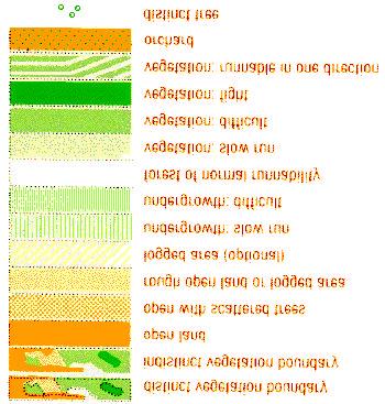
12 Orienteering map symbols: Black symbols are used for rock features (for example, boulders, cliffs, stony ground) and for linear features such as roads, trails and fences as well as for other man-made features (for example, ruins and buildings) Brown symbols are used for landforms such as contour lines, small knolls, ditches, earth banks. Blue is used for water features: lakes, ponds, rivers, streams, marshes. Yellow is to show vegetation - specifically for open or unforested land. The density of the yellow color shows how clear the area is: brightest yellow for lawns, pale yellow for meadows with high grass. Green is used to show vegetation that slows down the passage of an orienteer. The darkest green areas, called "fight", are almost impassably overgrown. White on an orienteering map signifies forest with little or no undergrowth - forest that an orienteer can run through. Purple (or red) is used to mark the orienteering course on a map. Conditions that are specific to an event (such as out-of-bounds fields in which crops are growing) are also designated in red or purple. 12


13 Compass Good compasses have a fluid-filled housing; the fluid dampens the motion of the needle, so that you can use the compass without holding it perfectly still. Avoid inexpensive compasses that do not have fluid-filled housings. The compass needle is painted in two colors. Assuming that the compass is held flat, the red end points to north, and the white end to south. An interesting detail is that there are northern- and Southern Hemisphere compasses. This has to do with the fact that the magnetic field lines, to which a compass needle aligns, point into the earth at the north and south magnetic poles. In the Northern Hemisphere the north end of the needle is pulled downwards, and the south end is counterweighted to balance the needle. When you use a northern hemisphere compass in, say, Australia, the south end of the magnet is pulled downwards by the magnetic field, and is also heavier than the north end - resulting in a needle that catches and drags on the bottom of the compass housing when the compass is held horizontal. A good compass will last a long time. However, some things can go wrong with a compass: the plastic components can break, or the housing can develop a leak. Over time, the fluid within the housing may turn an opaque blue-green. And, very rarely, the magnetization of the compass needle may reverse, so that the south end now points to north. Types of Orienteering compasses: There are two main types of orienteering compasses: The baseplate (sometimes called protractor compass or map) This type of compass was invented by the Kjellstrom brothers during the World War II era. It consists of a rectangular baseplate, which is marked with a red arrow pointing along the long axis, and a rotating compass 13
14 housing marked in degrees (360 degrees for the full circle in most of the world, but 400 on some European compasses). Marked on the floor of the rotating compass housing are an arrow and a set of lines parallel to that arrow. Additional features may include a lanyard for attaching the compass to the wrist, scale bars for measuring map distances along one or more edges of the baseplate, a magnifying glass for reading fine map detail, and templates of a circle and triangle for marking orienteering courses on the map. The thumb compass In the mid 1980s, a top Swedish orienteer developed an alternative to the baseplate compass by reshaping the baseplate and adding a strap for attaching the compass to his thumb. This compass is then placed on the thumb of the left hand, which holds it on the map. The advantage of this system is that the map and compass are always read as a unit, the map is aligned more easily and quickly, plus one hand is left free; the disadvantage is that running very accurately on a bearing is more difficult. Personal preference usually determines the type of compass that is used; world championships have been won using both types. Using a compass for orienting the map This is a simple skill, and is probably the most important use of the compass: 1. Hold your map horizontally. 2. Place the compass flat on the map. 3. Rotate the map until the "north lines" on the map (a series of evenly spaced parallel lines drawn across the map, all pointing to magnetic north) are aligned with the compass needle. The map should now be oriented to the terrain. This makes it much easier to read, just as text is easier to read right side up than upside down. Taking a bearing Every direction can be expressed as an angle with respect to north. In the military and the boy scouts, this is called an "azimuth", and bearings are expressed as a number of degrees. Orienteers take the easy way out, just setting the angle on their compass and keeping the needle aligned, which in turn keeps them going in the right direction. A simple set of step-by-step instructions for setting a bearing on a baseplate compass are: 1. place the compass on the map so that the direction of travel arrow is lined up with the way you want to go 2. turn the compass housing so that the arrows engraved in its plastic base are parallel to the north arrows drawn on the map (make sure the arrowhead points north and not south) 3. take the compass off the map and hold it in front of you so that the direction of travel arrow points directly ahead of you 4. rotate your body until the compass needle is aligned with the arrow on the base of the compass housing 5. pick out a prominent object ahead of you along the direction of travel, go to it, and repeat the process (this way you can detour around obstructions but still stay on your bearing) How important is the compass? The most important navigational aid used in orienteering is the human brain. One other navigational device is in allowed and in general use: the compass. Compasses are useful for taking bearings and for orienting the map so that it is aligned with the terrain - but it is possible, in most areas, to complete a course quite easily and efficiently without a compass (an exception: it would be difficult to navigate flat areas poor in prominent features without a compass). The compass is the only legal navigational aid that can be used in orienteering. Altimeters are specifically prohibited and GPS units are implicitly prohibited by the rules. It has been stated that GPS units could be very useful and helpful aids, but when the question of how an everyday orienteer would use a GPS unit to defeat the reigning US champion in a race was raised, the only valid reply was: "I would wait at the first control for him, 14

15 use the GPS unit to knock him out, and then proceed on to victory". Technology, however powerful, is no match for basic navigational ability - even in the hands of a good orienteer who is also a technological wizard. Beginning orienteers should learn basic compass skills and work on mastering map reading. Declination Unfortunately, true north and magnetic north are not located at the same place. A compass needle points to magnetic north; the number of degrees East or West that magnetic north and true north are separated by is known as declination. Many compasses have built-in declination adjustments; others do not. For accurate compass readings, it is necessary to account for declination. The isogonic chart at right roughly shows declination for the United States. If, for example, you are in the White Mountains of New Hampshire, you will have a west declination of about 16 degrees, meaning that magnetic north is 16 degrees west of true north. By aligning your magnetic needle 16 degrees west of true north (360 degrees minus 16 degrees, or 344 degrees), the azimuth ring will then be correctly oriented for true north. For compasses that do not have built-in declination adjustments, it is common practice to place a small piece of tape at the declination point of the azimuth ring. In other words, if you are in an area with a westerly declination, align the magnetic end of your compass needle to 360 minus the declination. If, however, you are in an area with an easterly declination, align the magnetic end of your compass needle to the number (degree) on your dial that is the declination. 15
16 The Earth's magnetic field is actually a composite of several magnetic fields generated by a variety of sources. These fields are superimposed on each other and through inductive processes interact with each other. The most important of these geomagnetic sources are: a. the Earth's conducting, fluid outer core (~90%); b. magnetized rocks in Earth's crust c. fields generated outside Earth by electric currents flowing in the ionosphere and magnetosphere d. electric currents flowing in the Earth's crust (usually induced by varying external magnetic fields) e. ocean current effects These contributions all vary with time on scales ranging from milliseconds (micropulsations) to millions of years (magnetic reversals). More than 90% of the geomagnetic field is generated by the Earth's outer core. It is this portion of the geomagnetic field that is represented by the Magnetic Field Models. Location: Birmingham, AL Latitude: 33d 22m North, Longitude: 86d 41m West Year Declination Year Declination Year Declination d 39m E d 38m E d 14m E d 39m E d 43m E d 34m E d 37m E d 45m E d 48m E d 38m E d 39m E d 7m E d 39m E d 35m E d 30m W d 35m E d 12m E d 5m W d 35m E d 53m E d 44m W d 19m W 16

17 Orienteering Clue Symbols Although clues are always written out in English (or the local language) for beginners' courses, clues for intermediate and advanced courses are given as symbols in a table format. To the uninitiated, this can look like hieroglyphics, but the system is quite simple to master and is more compact and specific than a written description - and has the advantage of being easily understood the world over. The example shown here begins with a course designation (in North America, Orange refers to the intermediate level course). The second entry in the heading is the length of the course (in kilometers or meters), which is always measured as the minimum distance an orienteer would have to travel to complete the course (in other words, along the straight line except where an obstacle such as a lake or out-of-bounds area forces a deviation from the line. The third entry in the heading is the climb, in meters, as measured along the "ideal" route (as determined and measured by the course setter). Each succeeding line in the clue list describes the location of a control, and the final line describes the approach to the finish from the final control For example: column a: The control number (in this case, the fourth control) column b: The control code appearing at or near the flag (49) column c: Which of several similar features (the middle one) column d: The feature (the boulder) column e: Details of the feature's appearance (none given) column f: Dimensions of the feature (1.5 m high) column g: Location of the control marker (the north side) column h: Other information (drinks available) 17
18 2003 IOF SYMBOLS Vulcan Orienteering Club USOF United States Orienteering Federation A B C class D E F length G H climb RED 7250m 300m Description of the Control A - control number B - control code C - which (of any similar features) D - the control feature E - details of the feature appearance F - dimensions of the feature G - location of the marker H - other information meters Funnel tape to the finish meters Taped to the finish meters No tape meters Tape from control meters Tape to map exchange C - Which Feature Northern Southeastern Upper Lower Middle 200m 3x1 5x1 D - Control Features Landforms terrace spur reentrant earth bank quarry Earth wall Erosion gully Small erosion gully hill knoll saddle depression small depression pit broken ground Rocks & Boulders cliff, rock face Rock pilar cave boulder boulder field Boulder cluster Stony ground bare rock Narrow passage Water & Marsh lake pond waterhole River, watercourse Minor water channel narrow marsh marsh firm ground in marsh well spring Water tank, water trough Vegetation field semi-open land forest corner clearing thicket linear thicket vegetation boundary tree cluster single tree Root stock Man-made road trail ride bridge powerline pylon - pole Tunnel Stone wall Fence Crossing point building Ruin Pipeline Tower Boundary stone Fodder rack Stairway Special features spcial item spcial item Country Specific Shooting platform salt lick charcoal burning Platform anthill E - appearance shallow deep overgrown open rocky marshy sandy Needle leaved deciduous ruined, collapsed F - dimensions 1 2x2 Height (meters) Size (meters) Combinations junction crossing G - Location Northeast side Southeast edge West part East corner (inside) South corner (outside) Southwest tip on a bend Northwest end of upper part lower part on top of Foot (no direction) Northeast foot Beneath Between Other Information first aid refreshment radio control control check 18
 Attack Point - an obvious feature near the control point from which the control can be located by navigating carefully with map and compass.")
 - an obvious feature on the map and ground located beyond a control or other sought after feature which indicates that the target")
19 Orienteering Terms Aiming Off (also called offset technique) - to deliberately aim to one side of a control or feature so that you know which way to turn upon hitting the feature before seeing the control. (see dotted line from 2 to 3 in map figure above) Attack Point - an obvious feature near the control point from which the control can be located by navigating carefully with map and compass. Bearing - the direction of travel as indicated by the compass. Catching Feature (also called a Collecting Feature or Backstop) - an obvious feature on the map and ground located beyond a control or other sought after feature which indicates that the target feature has been over-shot. Check Point - an obvious feature on the map or ground which can be used to check that you are keeping to your chosen route. Contour - a line on a topographic map that connects points of equal elevation. Control/ Control Marker/ Marker- a trapezoid-shaped marker (usually orange or red and white) used to mark features on an orienteering course, usually with clipper or control punch attached to mark a control card as proof of arrival. 19

20 Control Card (Punch Card)- a card carried by each participant, which is punched at each control feature to verify the visit. Control Circle - a circle drawn around a feature on the map to indicate the location of a control marker. The feature should be in the exact center of the circle. Control Code - letters (or numbers) on a control marker which enable participants to verify that it is the correct one. Control Description - a list given to each participant which briefly describes each control feature in order. It also gives the control code. Control Feature - a natural or man-made feature on or next to which the control is hung. Control Marker - see control. Control Number - a number drawn beside each control circle on a map. On a cross-country course, they indicate the order in which the controls must be visited. The top of the number should point to North. Control Punch - a small plastic clipper with different designs of pins. Used to verify each control feature has been visited. Course - a sequence of control points marked on the map which are to be visited by the orienteer. Cross Country Course - the classic course used for all major competitions. Control features must be visited in the prescribed order. Dog-Leg - positioning of a control which favors approaching and leaving a control by the same route, thereby leading other competitors to the control. Course design which results in a dog-leg should be avoided. Fine Orienteering - precision navigation in detailed terrain usually demanding careful use of map, compass and pace counting, and usually involving short course legs. Finish Symbol - If it shares the same location as the start: If its location is separate from the start Folding the Map - orienteers fold their maps to aid concentration on the leg being run, and to facilitate thumbing their position. Handrail - A linear feature which closely parallels your route and acts as a handrail to the next control. Knoll - a small hill Leg - a section of a course between two control points. Legend or Key - a list of the symbols represented on the map. Linear Feature - a feature that extends in one direction for some distance e.g., paths, fences, stonewalls, and streams. Used as handrails. 20
21 Line Event - event where maps are marked with a line indicating the exact route to be followed. Participants mark the precise location of each of the controls they find along the route. Master Map - a map displayed near the start from which competitors copy their courses onto their blank map. More experience orienteers will copy the course onto their map while the clock is running. Novices should be allowed to do this before being given a start time. In bigger events, the courses are pre-printed on the maps. Offset Technique - see Aiming Off Orienting the Map - matching the orientation of the map to the features on the ground. This is one of the fundamental skills in orienteering, and leads to successful navigation. The map can be oriented either by comparing the map directly with the terrain or by using a compass to orient to north. Pace Counting/ Pacing - a system of counting double-paces (every time the left or right foot hits the ground) to measure distance covered. An orienteer would measure the distance between two points using the scale on the compass and then count his/her paces until the distance was covered. Pacing allows an orienteer to know when he or she has perhaps gone too far and missed the feature they were looking for. Point Feature - a feature in the terrain that only occupies a small area. Frequently mapped examples are boulders, pits and mounds, stumps, and root mounds. They are not suitable as control sites for novice courses unless they are on a handrail. Precision Bearing - some compasses can be used to take a precise bearing (direction clockwise from north) which can then be followed in the terrain Punching - the act of marking the control card with the punch. Reentrant - a small valley running down a hillside. A stream cut into a hillside would create a reentrant-type feature. On a map, the contour lines which describe a reentrant point uphill. Relocating Feature is an unmistakable feature, such as a large lake or hilltop, junction of roads, trails, streams, etc At all levels, it is possible to become disoriented and lost. When you realize you are lost, you must relocate. This means giving up the search for your control and instead, finding some big obvious feature to again find yourself on the map. Then you can choose to abandon the course or have another attempt at your control. Safety Bearing - a compass bearing which, if followed, will bring a lost orienteer to a road or other major, recognizable feature. It maybe added to the control description list as a safety measure. Safety Whistle - a whistle which can be used if a participant is injured or lost. The International Distress Signal is six (6) short blasts repeated at one (1) minute intervals. Score Event - participants visit as many controls as possible within a fixed time, e.g., 30 minutes. More distant or difficult controls are often allotted a higher point value. Points are deducted for each amount of time the orienteer arrives after the allotted time is up, say 5 points for every minute. The person with the most points wins. Spur - a small ridge. Star Event - an event in which participants must return to the start between each control. This can be used for relay events or for keeping close contact with novices. Start Symbol -a triangle used to locate the start on the map. It should be centered exactly over the starting point, and one apex should point toward the first control. String Course - a course marked with a continuous string line. These courses are often used with very young children to give them familiarity with the forest. Thumbing - a technique for holding the map, using with your thumb to indicate your present location. To do this properly, it is often necessary to fold the map 21
22 Measuring Distance There are three main techniques of measuring distance: 1. Pace counting 2. Timing 3. Visual estimation Pace counting is probably the most precise of the three, and visual estimation is probably the least precise. To pace count, you need to know how many paces (a pace is two strides) it takes you to cover a fixed distance, like 100 meters. Find this out by measuring a 100 meter stretch of terrain, then counting the number of paces you take to traverse it. Try to simulate the speed and form you have when you are actually doing a course. You will get a pretty reliable number if you do this several times and take the average. Then when you are on the course, for every 100 meters you have to travel between an attack point and the next control, go that many paces. For example, I take about 35 paces to go 100 meters at Magnuson Park, so if I wanted to go 160 meters, then I would take 1.6 * 35 = 56 paces. Keep in mind that pace length depends on the terrain; it is longer on roads and down hills and shorter in thick vegetation and up hills. Timing is a favorite method of estimating distance. It requires that you know how long it takes you to cover a fixed distance. (Again, 100 meters is convenient.) Then, you multiply that time by the number of hundreds of meters you want to go. Let's say it takes you 45 seconds to go 100 meters over competition terrain. If you want to cover 220 meters, then you run for 2.2 * 45 = 99 seconds, or 1:39. One weakness of this technique is that it only works when you go at a constant pace without stopping, so if you make a mistake and stop to figure out where you are without looking at your watch right away, then you can't tell how far you've gone. An advantage of timing is that you don't need to count like you do when pacing; your watch does it for you, so you can concentrate on the map and compass. Visual estimation. There are two ways you can do this: in increments or all at once. The incremental method is similar to pacing and timing: You figure out how many of a given distance you need to go to travel your desired distance. For instance, Alain Berger of the Swiss national team uses 30 meter segments--he knows how far 30 meters looks. So if he wants to travel 165 meters from his attack point to the control, he counts off 165/30 = meter blocks. The other (all at once) timing method is only useful for short distances or where the visibility is very good. If you need to go 110 meters, then you look in the direction of travel and pick a point that looks about one football field with endzones away. In open terrain, you can sometimes see the control feature from a considerable distance if you know where to look. Some advantages of visual estimation are that it encourages you to look far ahead (which helps you pick out map features you recognize and decide where the running is best) and that it doesn't depend on the runnability of the terrain. A drawback is that it's really imprecise, unless you have a very good eye; the perception of distance changes with different light conditions, topography, and vegetation. 22
23 Standard Orienteering Course Colors (United States) The most important thing to remember: courses are NOT set by length, but by the skills they test White (2-3 km) beginners - all on trails, roads or marked routes for learning the logistics of the sport (punching etc) start learning the map colors and symbols Yellow (3-5 km) advanced beginner - Close to trails and other handrails (fences. streams). Use this course to learn all the map symbols and colors, don't just go from control to control as fast as you can Orange (4.5-7 km) intermediate - where you first go cross-country. It is very challenging, sometimes as long as Green, but still with safe navigational features. i.e. a strong attack point within 100m of a control. It is planned to help you learn all your advanced skills. Stay with the Orange course until you know all the advanced techniques. This is a good course for those with navigational skills honed by backpacking etc, but no specific "Orienteering, the sport", skills Brown (3-5 km), Green (4.5-7 km), Red (6-10 km) and Blue (8-14 km) all equally technically advanced - very subtle control points. The navigational techniques required are quite complex and you should be able to really 'read the map' at a detailed level and have all the O techniques mastered. Brown is the least physical and for older, experienced orienteers (F60+, M65+), and Blue being a long tough haul(m21+). These advanced courses are NOT for you, even with (topo) backpacking or other navigational experience, until you have tried the ORANGE and been successful several times. We urge you to respect this for your own safety and enjoyment, and in consideration for the event organizers. LOCAL MEET COURSE PLANNER'S NOTES Easy Courses (WHITE and YELLOW): 1. Points should be on two features with linear route between, for example, points might be a stream and road junction or a trail at vegetation boundary. 2. Controls should be highly visible, usually hung 3-4 feet high. Medium Courses (Orange): 1. Points should be on major terrain features with a close attack point. example: a boulder 100 meters from a trail junction. 2. Controls should be visible when at the feature, usually hung 3-4 feet high. Hard Courses (Brown, Green, Red and Blue): 1. Points on minor terrain features with no convenient attack point. example: the foot of a one meter cliff in a complicated re-entrant system. 2. Controls should be visible when at the feature, usually hung 1-3 feet high. 23
24 LOCAL MEET COURSE DESIGN GUIDELINES General Course Design -- All Courses 1. Beginners are equally important people. 2. The time it takes to complete courses is more important than the length. 3. White, Yellow, and Orange courses should not share legs. 4. Every leg on Orange, Brown, Green, Red, and Blue should have route choices. 5. Direct line by compass should only rarely be the best way to go. 6. Streamers should be used on White and Yellow whenever there can be confusion. 7. Legs should get longer as the difficulty increases. 8. In hot weather and dense vegetation, make everything a bit shorter and easier to find. Course Design -- WHITE 1. Stay on obvious handrails 100% of the time, preferably trails. 2. Controls should be hanging on the near side of the feature. 3. Controls should be very easy to find, especially the first few. 4. The first control should be visible from the Start 5. Later legs can have two route choices, both on handrails. 6. Use positional controls to keep runners on the handrails. 7. Don't hang the controls too high for kids to reach. 8. Avoid putting controls from other courses where White course people can see them. Course Design -- YELLOW 1. The Yellow should follow handrails but points are off handrails. 2. Handrails may have short gaps or be subtle (fences, streams). 3. Attack points should be on the handrail. The feature can be visible from the handrail but should be off the handrail to encourage map reading. 4. Have various types of features for variety. 5. There should be a some route choice alternatives. 6. Have good catch features behind points to stop overshooters. 7. Use positional controls to keep runners near handrails. 8. There should be very little contour reading necessary. Course Design -- ORANGE 1. Orange should bridge the gap between attack points on handrails and difficult-to-find attack points. 2. Err on the side of too easy. 3. Use features of medium difficulty: a. easy-to-find features less than 200m from attack point b. very large re-entrants and ponds 4. more difficult points near easy to find attack points 5. easy to find points with many route choices 6. Some legs should be almost Yellow, others almost Red. 7. Have some handrails but emphasize cross country. 8. Always have catching features beyond the feature. Course Design -- BROWN, GREEN, RED, and BLUE 1. Test navigation and route choice skills, not compass ability. 2. Use intricate areas of the map as much as possible. 3. Make the competitor concentrate on navigation all the time. 4. Offer difficult-to-decide-between route choices on every leg. 5. There must be some variety in the features. 6. The most difficult navigational route should be the fastest, easy routes should take longer. 7. Avoid poorly mapped areas or make the legs easier in these areas. 8. Controls should be easily found once at the feature. 9. Map must be good in the area of the control or you must give good map corrections before the runners start. 10. Best route choices should not be the most miserable physically-avoid swamps/fight except as route choice. 11. Trail running should be only about 10% of the total distance. 24

25 Route Choice in Orienteering Navigation in orienteering can be reduced to two factors: 1. Choosing one of the many possible routes to the control 2. Finding your way along that route Once you have learned some basic techniques and rules of navigation, it should always be possible to find the control - given that the map is accurate. Therefore, much of the variation among individuals' times may come from their choice of routes. This is particularly true when speed through the terrain varies dramatically in different places, which can occur for any number of reasons: 1. A trail is faster than the woods 2. Vegetation mapped as green may be very slow going 3. Going uphill and then down may be slower than going the long way around 4. A potentially faster route may offer no navigational aids, while a longer/slower route may provide a navigationally easy approach to the control site. Each individual may have particular strengths. one may run very fast on a trail, but slow down dramatically in the forest another may have no great turn of speed, but chug away steadily uphill still another may have no confidence in her ability to follow a compass bearing, but may be able to read contours very well. What is the effective distance in terms of effort added by climb? A common rule of thumb is to add ten meters to the distance for each meter of climb. Climbing 4 contour lines (5 meters each x 4 = 20 meters) would be equivalent to adding 200 meters to your route. The best route for a beginner may not be the best route for an advanced orienteer. Hence the choice of a route on a given leg between controls may have many possible "best" solutions. But, in turn, the true best solution may not be immediately apparent to orienteers who don't plan carefully. As an example, the map shown here gives the route choices and variations taken by the top orienteers at the Swedish National Championships some years ago (recall that there are about as many Swedish orienteers as all other countries combined). Each orienteer's route is shown as a single red line, and at places where several individuals went the same way, red numbers show how many orienteers followed that portion of the route. Some fields (yellow) were out of bounds because crops were growing and are marked with red cross-hatching. Although this is perhaps an extreme example, it does show the variety of routes (and combinations of subsets of routes) that may be possible on a single leg. 25

26 After running an orienteering Course Requirement 7 of the Orienteering Merit badge requires you to write a report after each orienteering course. Most orienteers will mark their route on the map after they finish their course. Sometimes they share this info with others to help them improve their ability to choose good routes. Here is a partial example of what should be done to meet the requirement: Include a copy of the map with the course and control descriptions: Draw your actual route on the map. In this case it is shown with purple dots. You may want to use a highlighter, marker or a pencil. START CONTROL 1 Arrived at the start about 15 minutes ahead of scheduled start time. Took a few minutes to stretch and warm up. The start was on a trail. Before the start got a compass bearing for the trail. When the whistle blew, turned over 26
Control Description Sheet 1
 Control Description Sheet 1 Headings I0A Example M20 M21 M35 1 8.8km 250m Event Title Classes (optional) Course Code; Course length, Height climb Start location as if it was a control. First Control Description
Camp Jack Wright PERMANENT ORIENTEERING COURSE (2004)
") Camp Jack Wright PERMANENT ORIENTEERING COURSE (2004) WHAT IS ORIENTEERING? The skill which enables a person to navigate with a map. In the competitive sport, the winner is the person who finishes in the
Camp Jack Wright PERMANENT ORIENTEERING COURSE (2004) WHAT IS ORIENTEERING? The skill which enables a person to navigate with a map. In the competitive sport, the winner is the person who finishes in the
General Considerations For Cross Country Orienteering Courses: Design and Set Guidelines
 General Considerations For Cross Country Orienteering Courses: Design and Set Guidelines Objective Orienteering's slogan is that it is "the thinking sport." Doing well requires a combination of physical
5 MAP SPECIFICATION FOR SKI-ORIENTEERING
 5 MAP SPECIFICATION FOR SKI-ORIENTEERING 5.1 General Maps for ski orienteering are based on the specifications for foot-orienteering maps. However in order to meet the specific requirements put on the
International Specification for Control Descriptions
 International Specification for Control Descriptions INTERNATIONAL ORIENTEERING FEDERATION 2018 INTERNATIONAL ORIENTEERING FEDERATION International Orienteering Federation Drottninggatan 47, 3 1/2 tr.
Below is an example of a well laid-out template of a route card used by the Sionnach Team which is a good format to begin with.
 Route Card A route card is used as a navigational aid to hill walkers by setting out a step by step plan for an intended hike. It is good practice to make out a route card before every hike you or your
4.1 Landforms. Note: dimensions are specified in mm at the scale of 1: All drawings are at 1:7 500 for clarity only.
 4.1 Landforms Note: dimensions are specified in mm at the scale of 1:15 000. All drawings are at 1:7 500 for clarity only. OM = Outside measure IM = Inside measure CC = Centre to centre 0.2 0.4 OM 0.4
ISOM & ISSOM forbidden symbol comparison
 & forbidden symbol comparison Forbidden symbols and their relatives Symbol 2000 (Long, Middle) 2007 (Sprint) 201 Impassable cliff An impassable cliff, quarry or earth bank (see 106) is shown with a 0.35
INTERNATIONAL ORIENTEERING FEDERATION 2010
 INTERNATIONAL ORIENTEERING FEDERATION 2010 Valid from 15 May 2010 1 INTRODUCTION Orienteering is a world-wide sport. A common approach to the interpretation and drawing of orienteering maps is essential
Backpacking Merit Badge Workbook
 Merit Badge Workbook This workbook can help you but you still need to read the merit badge pamphlet. The work space provided for each requirement should be used by the Scout to make notes for discussing
LAKE NEEDWOOD ORIENTEERING MEET QUANTICO ORIENTEERING CLUB SEPTEMBER 18, 2011
 NATIONAL ORIENTEERING DAY LAKE NEEDWOOD ORIENTEERING MEET QUANTICO ORIENTEERING CLUB SEPTEMBER 18, 2011 COMBINED EVENT NOTES, including: National Orienteering Day Course Designer s Notes Super String-O
Introduction to Topographic Maps
 Introduction to Topographic Maps DIRECTIONS: Read all of the following content. READ EVERYTHING!! At the end of the packet, you will find two topographic maps. Your task is to indentify each of the elevations
The Atlas of Hillforts of Britain and Ireland. Hillfort survey notes for guidance
 The Atlas of Hillforts of Britain and Ireland Hillfort survey notes for guidance The collection of surveys for the Atlas is now finished but you can use this form and the accompanying Notes for Guidance
Trail Phasing Plan. Note: Trails in the Clear Creek Canyon area (Segments will be finalized in the future to minimize wildlife impacts
 Note: Trails in the Clear Creek Canyon area (Segments 2 5 and a future JCOS connection) will be finalized in the future to minimize wildlife impacts Trail Phasing Plan P Parking 3 Easy Trail Intermediate
Backpacking Merit Badge Workbook
 Merit Badge Workbook This workbook can help you but you still need to read the merit badge pamphlet. The work space provided for each requirement should be used by the Scout to make notes for discussing
Orienteering. The fundamental outdoors skill!
 The fundamental outdoors skill! Orienteering Nothing will make you feel more confident in the out of doors like knowing how to find your way in the woods. Orienteering Prepared by: Jeffrey Lybarger Assistant
Hiking. Lesson 4.1. Fitness. Hiking
 Lesson 4.1 By Carone Fitness If you enjoy walking, you will probably enjoy hiking. The main difference between hiking and fitness walking is the change in terrain. is typically done in a forest, wilderness,
Scout s Name: Counselor s Name: Counselor s Ph #:
 BACKPACKING MERIT BADGE WORKSHEET This worksheet is not required but is designed to help you with this merit badge. Requirements revised: 2002, Worksheet updated: January 2004. Scout s Name: Date: Counselor
MAPPING OF ROCK FEATURES 2.9
 MAPPING OF ROCK FEATURES 2.9 Introduction 1 The mapping of rock in recent years has been one of the strengths of orienteering in Australia. This has been largely because our granite terrain has presented
CAMPING Merit Badge Requirements
 Scout Name: Unit #: Date: CAMPING Merit Badge Requirements 1) Show that you know first aid for injuries or illnesses that could occur while camping, including hypothermia, heatstroke, heat exhaustion,
SCOUTING. Because without OUTING it would just be SC
 SCOUTING Because without OUTING it would just be SC Camping Merit Badge Camping is one of the best-known methods of the Scouting movement. When he founded the Scouting movement in the early 1900s, Robert
Troop 23 Scout Skills Review (Revised )
") Troop 23 Scout Skills Review (Revised 10-27-11) This Skills Review is to be done by the 1 st Class and Life Scout candidate with an Eagle Scout adult leader, before the Scout s 1 st Class and Life Scout
Troop 23 Scout Skills Review (Revised 10-27-11) This Skills Review is to be done by the 1 st Class and Life Scout candidate with an Eagle Scout adult leader, before the Scout s 1 st Class and Life Scout
APPENDIX D: SUSTAINABLE TRAIL DESIGN. APPENDICES Town of Chili Parks and Recreation Master Plan Update
 APPENDIX D: SUSTAINABLE TRAIL DESIGN APPENDICES Town of Chili Parks and Recreation Master Plan Update Sustainable Trail Construction Sustainable trails are defined by the US Forest Service as trails having
Camping Merit Badge Workbook
 Merit Badge Workbook This workbook can help you but you still need to read the merit badge pamphlet. This Workbook can help you organize your thoughts as you prepare to meet with your merit badge counselor.
Outdoor Education Worksheets
 Outdoor Education Worksheets OUTDOORS You will need: First Aid Kit Appropriate clothing for whole group (sunny/wet weather) Charged mobile phones and appropriate numbers of adult helpers in case of group
CHAPTER 12: AERONAUTICAL CHARTS AND NAVIGATION
 CHAPTER 12: AERONAUTICAL CHARTS AND NAVIGATION Once you start to venture out from your home gliderport, you need to be able to figure out where you are and how to get where you want to go. Aeronautical
Figure 1 Understanding Map Contours
 Figure 1 Understanding Map Contours The light brown lines overprinted on topographic maps are called contour lines. They indicate the elevation above sea level of land features and thus permit you to view
SHELTERS, OUTDOOR SURVIVAL AND ORIENTEERING REVIEW PAD30
 SHELTERS, OUTDOOR SURVIVAL AND ORIENTEERING REVIEW PAD30 Before you Build your shelter you should consider the following: Hours Before Dark Close to dark = build something easy Season Summer = Higher ground
Ranger Award Core Requirements
 Ranger Award Core Requirements CORE REQUIREMENTS Do all of the following core requirements. 1. First Aid Complete a standard first aid course plus the American Red Cross When Help Is Delayed module or
Map & Compass so easy a caveman can do it!
 Map & Compass so easy a caveman can do it! Compass Basics Opening Comments Terms of a compass Boxing a needle Get a bearing (you to a point) Get a bearing (a point to you) Orienting a map Get a bearing
Scout s Name: Counselor s Name: Counselor s Ph #:
 CAMPING MERIT BADGE WORKSHEET This worksheet is not required but is designed to help you with this merit badge. Requirements revised: 2OO6, Worksheet updated: 2006. Scout s Name: Date: Counselor s Name:
Final Plan 03/14/2017. Dunes Moraine District Spring Camporee 2017 April 28-30, 2017 Sunset Hill County Park Valparaiso, IN Update 03/14/17
 Dunes Moraine District Spring Camporee 2017 April 28-30, 2017 Sunset Hill County Park Valparaiso, IN Update 03/14/17 Pioneering Camporee Provide an opportunity for Scouts to: 1. 1st Class Lashing 2. Earn
China Aeromodelling Design Challenge. Contest Rules China Aeromodelling Design Challenge Page 1 of 14
 China Aeromodelling Design Challenge Contest Rules 2014 Page 1 of 14 LIST OF CONTENTS I VTOL AIR CARGO RACE... 3 1 OBJECTIVES... 3 2 REGISTRATION ELIGIBILITIES... 3 3 AIRCRAFT CONFIGURATIONS... 3 4 SITE
York District Fall Camporee Path to Advancement
 York District Fall Camporee 2014 Path to Advancement Afternoon Program The afternoon of the Fall Camporee will consist of two programs. One of which is a Life to Eagle program that is designed for seasoned
Second Class Rank Workbook
 Workbook This Workbook can help you organize your thoughts as you prepare to meet with your Scout Leader. You still must satisfy your Scout Leader that you can demonstrate each skill and have learned the
Adult Leader Position Specific Training Record
 Boy Scouts of America Daniel Webster Council Adult Leader Position Specific Training Record Course #: S11 Unit #: Course Title: Introduction to Outdoor Leader Skills Adult Leader Trained: Adult Trainer:
Aviation Merit Badge Workbook
 Merit Badge Workbook This workbook can help you but you still need to read the merit badge pamphlet. The work space provided for each requirement should be used by the Scout to make notes for discussing
William Henry Harrison District KLONDIKE DERBY Leader s Guide January 22-24, 2016 Camp Friedlander 581 Ibold Rd, Loveland, OH 45140
 William Henry Harrison District KLONDIKE DERBY Leader s Guide January 22-24, 2016 Camp Friedlander 581 Ibold Rd, Loveland, OH 45140 What is a Klondike Derby? Many years ago, men raced across the Alaskan
GC 225 Lecture Exam #2
 GC 225 Lecture Exam #2 Direction- path along which something is moving. 3 Types; - COMPASS DIRECTIONAL NAME (32 in total) - BEARING (four 0 o - 90 o ) - AZIMUTHS (0 o - 360 o ) Compass (32 named points)
Second Class Personal Growth Agreement Conference
 Second Class Personal Growth Agreement Conference Scout: Age: years months School Grade I have been in Scouts for months, including months as a Tenderfoot Scout. SCOUT SPIRIT: As a Tenderfoot, I have continued
Webelos Woods & Fall Camporee
 Grand River District Webelos Woods & Fall Camporee September 29-October 1, 2017 Boy Scouts of America Camp Stigwandish Lake Erie Council Leaders Guide Volunteer Opportunities- WE NEED YOU!!! We are looking
Note: Coordinates are provided as Universal Transverse Mercator UTM Zone U21, North American Datum 1983 (NAD 83).
.") Northern Traverse Route Description The Northern Traverse (formerly the North Rim Traverse) is an unmarked and rugged backcountry hiking route. It is known be a demanding hike, because of its terrain and
Northern Traverse Route Description The Northern Traverse (formerly the North Rim Traverse) is an unmarked and rugged backcountry hiking route. It is known be a demanding hike, because of its terrain and
[tips & tricks for modelmakers] Plate 4 Decks. Required tools
![[tips & tricks for modelmakers] Plate 4 Decks. Required tools](/thumbs/80/82218978.jpg "[tips & tricks for modelmakers] Plate 4 Decks. Required tools") Plate 4 Decks 2 4 18 3 Required tools 13 12 25 11 25 1 24 6 7 15 14 21 22 26 19 17 5 22 25 17 25 10 27 20 19 26 21 9 8 1 Gun locks 1 Do not cut the small link from the lock to the fret as it provides good
Plate 4 Decks 2 4 18 3 Required tools 13 12 25 11 25 1 24 6 7 15 14 21 22 26 19 17 5 22 25 17 25 10 27 20 19 26 21 9 8 1 Gun locks 1 Do not cut the small link from the lock to the fret as it provides good
PACIFICA DISTRICT 2010 KLONDIKE DERBY, Feb
 PACIFICA DISTRICT 2010 KLONDIKE DERBY, Feb. 26-28 Snow camping with Scouts is really cool! WHO?: All Boy Scouts WHAT?: The Klondike Derby is a youth-run winter camp out in the snow. (Yes, we actually hope
Camp Roosevelt February 22-24, 2019 The High Adventure Chill Out is a chance to join in one of the oldest traditions in Boy Scout history.
 Camp Roosevelt February 22-24, 2019 The High Adventure Chill Out is a chance to join in one of the oldest traditions in Boy Scout history. It's a wonderful opportunity for units to come together as a Council
Mark Beyer SMOKEJUMPERS. Life Fighting Fires
 Mark Beyer SMOKEJUMPERS Life Fighting Fires Extreme Risk Fighting forest wildfires is a dangerous business. Some wildfires, however, are easier to get to than others. They can begin to burn near roads,
Alternative Designs Report Joshua s Jumper
 Alternative Designs Report Joshua s Jumper By Elyssa Polomski, Michael Ballintyn, and Tianyi Xu Team # 21 Client: Joshua Bouchard Client Contact: Sue and Ron Bouchard, soupanony@aol.com, (508) 823-6113
Learning. to Hunt. Hosting a huntingbased outdoor skills event in your community
 Learning to Hunt Hosting a huntingbased outdoor skills event in your community Mary Kay Salwey, Ph.D. Wisconsin Department of Natural Resources 2004 Project Director Learning to Hunt Credits Mary Kay Salwey,
A Basic Manual on Knife Throwing
 A Basic Manual on Knife Throwing By J. B. Wood Illustrated by Roy Pelz The author of this manual, Mr. J. B. "The Old Man of the Hills" Wood (Kentucky) is a well known writer on firearms and the outdoors.
Camping Merit Badge Workbook
 Merit Badge Workbook This workbook can help you but you still need to read the merit badge pamphlet. The work space provided for each requirement should be used by the Scout to make notes for discussing
CAMPING Merit Badge Requirements
 Scout Name: Unit #: Date: CAMPING Merit Badge Requirements 1) Show that you know first aid for and how to prevent injuries or illnesses that could occur while camping, including hypothermia, frostbite,
Outdoor Skills Patch Program
 Overview The is a progressive, six-level program to help Girl Scout Daisies through Ambassadors learn and become proficient in outdoor skills. Through this patch program, girls explore leadership, build
Camp Geronimo Rainbow Trails
 Camp Geronimo Rainbow Trails With over 5,000 acres of surrounding national forest, the possibilities of getting out and seeing the wilderness are almost limitless. Camp Geronimo offers some of the greatest
A B C D E F G H I J K L M N O P Q
 Page 1 of 6 Leathercraft Projects To-Go Camp Adventure Leather LINK BELT (or Hatband, Wristband, Ankle-Band) Plus A Look Back Into The History of Camping Worldwide OBJECTIVE: Students will learn about
Longhorn Council Orienteering Score-O Participant Guide Sid Richardson Scout Ranch
 Longhorn Council Orienteering Score-O Participant Guide Sid Richardson Scout Ranch Overview Score-O is a fast paced team orienteering competition. It has been held continuously at the Sid Richardson Scout
Math in Motion Idlewild & SoakZone Copyright
 STUDENT PACKET MATH IN MOTION Your visit to Idlewild & SoakZone is an opportunity to not only have fun, but learn about math and the use of technology throughout the park. Use our Outdoor Classroom to
Mandolin Slicer Quite possibly the safest mandolin in the world
 Mandolin Slicer Quite possibly the safest mandolin in the world MANDOLIN & COMPONENTS Handle Upper Plate Safe Hands Food Holder Non-Slip Retractable Leg Julianne Blades (3 sizes) Waffle / Crinkle Cut Blade
Axe and Saw Permit: Safe Use of Axes
 Page 1 of 7 Objective: The objective of this workshop guide is for the Scout Leader and/or Scout youth to be able to describe and demonstrate safe use of the Axe. Axe or Hatchet: What s the difference?
NAVIGATION: CHARTS, PUBLICATIONS, FLIGHT COMPUTERS (chapters 7 & 8)
") NAVIGATION: CHARTS, PUBLICATIONS, FLIGHT COMPUTERS (chapters 7 & 8) LONGITUDE AND LATITUDE 1. The location of an airport can be determined by the intersection of lines of latitude and longitude. a. Lines
NAVIGATION: CHARTS, PUBLICATIONS, FLIGHT COMPUTERS (chapters 7 & 8) LONGITUDE AND LATITUDE 1. The location of an airport can be determined by the intersection of lines of latitude and longitude. a. Lines
UPDATES AND REQUIREMENTS
 2012 Fall Camporee NAVIGATION October 12-14, 2012 Sprague Brook Park 9674 Foote Road Glenwood, New York Hosted by the Polaris District UPDATES AND REQUIREMENTS 1. Please note that for some car GPS systems,
Fall Camporee Crossroads of America Council Pioneer District October, 2018
 Crossroads of America Council Pioneer District Fall Camporee 2018 26-28 October, 2018 Ransburg Scout Reservation 7599 Waldrip Creek Road Bloomington, IN 47401 Ok guys, I have been racking my brain trying
Geocaching at the Klondike 2014
 Geocaching at the Klondike 2014 What is a Geocache? What do they typically look like? What is Geocaching? What is a GPS? How does a GPS work? What does Geocaching have to do with scouting? How many geocaches
SEGMENT ASSESSMENT REPORT
 2017 SEGMENT ASSESSMENT REPORT SEGMENT 3: MT ROSE / TAHOE MEADOWS TO SPOONER SUMMIT REPORT SUMMARY This report is a compilation of information collected on the Tahoe Rim Trail during assessments performed
Orientation Booklet The New Airline Chart Series
 Orientation Booklet The New Airline Chart Series Copyright 2007 Jeppesen. All rights reserved. Table of Contents Introduction...1 Approach Chart...2 Heading...2 Plan View...2 Profile View... Minimums...
Route #2) Mt. Massive - Southwest Slopes
 Mt. Massive - Southwest Slopes") Route #2) Mt. Massive - Southwest Slopes Difficulty: Class 2 Ski: Advanced, D6 / R2 / III Exposure: Summit Elevation: Trailhead Elevation: Elevation Gain: Round-trip Length: Trailhead: County Sheriff:
Route #2) Mt. Massive - Southwest Slopes Difficulty: Class 2 Ski: Advanced, D6 / R2 / III Exposure: Summit Elevation: Trailhead Elevation: Elevation Gain: Round-trip Length: Trailhead: County Sheriff:
NEWMAR SERVICE SCHOOL
 NEWMAR SERVICE SCHOOL TRAINING INFORMATION GUIDELINE FOR FEBRUARY 2013 OUR PRODUCTS: NOVA DUAL PITCH AWNING G-2000/ G-1500 2 P a g e G-2085 G-5000 3 P a g e G-LINKS 4 P a g e NOVA/ G-2000/ G-1500 BASIC
October 18, SWBAT identify key features on topographic maps SWBAT identify landforms on topographic maps
 October 18, 2016 Aims: SWBAT identify key features on topographic maps SWBAT identify landforms on topographic maps Agenda 1. Do Now 2. Class Notes 3. Guided Practice 4. Independent Practice 5. Practicing
SLOPE CALCULATION. Wilderness Trekking School 1
 SLOPE CALCULATION By Joe Griffith, February 2014 Objectives Upon completion of this chapter, you will be able to: Read the rise-over-run from a topographic map. Convert the rise-over-run into a slope angle
ADK18: Conquering the High Peaks Southern Districts Klondike Saturday, January 27, 2018 F.D.R. State Park, Yorktown Heights, NY
 ADK18: Conquering the High Peaks Southern Districts Klondike Saturday, January 27, 2018 F.D.R. State Park, Yorktown Heights, NY Page 1 Event Information Schedule Registration: 8:00 to 9:00 AM Stations
ICAO Standards. Airfield Information Signs. ICAO Annex 14, 4th Edition Aerodrome Design and Operations
 ICAO Standards Airfield Information Signs ICAO Annex 14, 4th Edition Aerodrome Design and Operations Federal Aviation Administration U.S. Department of Transportation February 2004 ICAO Standards This
Egg-streme Parachuting Flinn STEM Design Challenge
 Egg-streme Parachuting Flinn STEM Design Challenge 6 07, Flinn Scientific, Inc. All Rights Reserved. Reproduced for one-time use with permission from Flinn Scientific, Inc. Batavia, Illinois, U.S.A. No
Property access tracks
 Property access tracks Planning, location, construction and maintenance The need for farm roads and tracks The efficient running of a property depends on, among other things, ready access to various locations
Spring accelerometers
 Spring accelerometers A spring accelerometer is a transparent plexiglass tube containing a small mass connected to two identical springs fixed to either end of the tube, with which we can measure the forces
LADYBUG POUCH. Plus A Look Back Into The. Camp Adventure Leather. History of Camping Worldwide. Leathercraft Projects To-Go
 Page 1 of 6 Leathercraft Projects To-Go Camp Adventure Leather LADYBUG POUCH Plus A Look Back Into The History of Camping Worldwide OBJECTIVE: Students will learn about the theme while creating a useful
Registration $12/person; $18 beginning on April 1 st. Registration ends April 20 th. April 27-29, 2018 Camp Buffalo Leader s Guide Register now at:
 Registration $12/person; $18 beginning on April 1 st. Registration ends April 20 th. April 27-29, 2018 Camp Buffalo Leader s Guide Register now at: https://sagamore.camp-master.com/events/2018sagamorespringcamporee/eventdetails.aspx
Pushing the Limits: Hiking Off-Trail in the Catskills
 Shari Aber I ve always pushed the limits. That s who I am. That s why I was working for my black belt in karate when I was 50 gave it up after I tore my meniscus and had to undergo the first of 3 arthroscopic
BOSTON MINUTEMAN COUNCIL, B.S.A PHILMONT ADULT APPLICATION DEADLINE: June 1, 2013
 BOSTON MINUTEMAN COUNCIL, B.S.A. 2014 PHILMONT ADULT APPLICATION DEADLINE: June 1, 2013 From: Boston Minuteman Council, High Adventure Committee We thank you for your interest in serving as an Adult Advisor
AGAP Antarctic Research Project Visualizing Data Learning About Antarctica From RADAR Data? Student Version
 AGAP Antarctic Research Project Visualizing Data Learning About Antarctica From RADAR Data? Student Version Name Date Image of Subglacial Lake network courtesy of NSF Ice Sheet: A large glacier that covers
Advisory Circular AC61-3 Revision 11 SUPERSEDED Define and identify, on a diagram of the earth, and explain the meaning of the following:
 Subject No 6 Air Navigation and Flight Planning Each subject has been given a subject number and each topic within that subject a topic number. These reference numbers will be used on knowledge deficiency
CBD 2014 Spring Camporee. Backpacking Merit Badge Course Description and Bring With List
 Backpacking Merit Badge Course Description and Bring With List This course is intended for scouts ages 13 or older who want an introduction to backpacking. It is good preparation for an upcoming first
Axe Safety Coaching Certification
 Axe Safety Coaching Certification Definitions Section 1 - Throwing Section 2 - Equipment and Field Section 3 - Participants Section 4 - Coaching Section 5 - Trick Shots Section 6 - First Aid Definitions
Axes. The information below will assist the Scout in obtaining their Forester badge.
 Axes The information below will assist the Scout in obtaining their Forester badge. Axes can come in different shapes and sizes, the two axes that are of most relevance to any Scout Troop will be the HANDAXE
Field Rules. Revised January NOTICE: Turbine powered aircraft of any kind are prohibited.
 Field Rules Revised January 2015 NOTICE: Turbine powered aircraft of any kind are prohibited. Use of the field: Flying field and facilities are for use by Members and Member Guests only. Spectators are
Skiing and Snowshoes on Un-groomed Fernan Saddle Terrain
 Skiing and Snowshoes on Un-groomed Fernan Saddle Terrain Three ski or snowshoe routes are available from the Fernan Saddle Parking Lot which either do not cover routes ordinarily groomed for snow machine
Geocaching Activity Plan
 Geocaching Activity Plan CONTENTS Outcomes... 2 Activity... 2 2.1 Outline... 2 2.2 Equipment... 2 2.3 Communication... 3 2.4 First Aid... 3 People... 3 3.1 Activity Instructor... 3 3.2 School Staff Member
Caitlin Pugh November 7 th, 2013 Technical Description Assignment
 Caitlin Pugh November 7 th, 2013 Technical Description Assignment 1. General Description The Swing-A-Way can opener is a handheld mechanical device used to open cans of all sizes. This device is a common
Fort Ticonderoga Carillon Battlefield Walking Trail Guide
 Fort Ticonderoga Carillon Battlefield Walking Trail Guide Copyright Fort Ticonderoga. Photo Credit Carl Heilman II Length: Approximately 1¾ mile Welcome to Fort Ticonderoga s Walking Trail Blue markers
ADOPT-A-TRAIL MANUAL C. Bailey-May
 ADOPT-A-TRAIL MANUAL C. Bailey-May 2011 1 ADOPT-A-TRAIL VOLUNTEER DUTIES Welcome to the White Mountain National Forest s Adopt-A-Trail (AAT) program and thank you for volunteering with us! This volunteer
Wicklow Mountains Path Survey
 Wicklow Mountains Path Survey Glenmacnass Tonelagee Start to Finish: O 114 030 to O 085 016 Altitude (lowest highest): 370m 817m Weather: Sunny day, hot Access: Military Road, Glenmacnass Surveyed by:
Snowmobile GUIDELINES FOR TRAIL SIGNING
 STATE OF NEW HAMPSHIRE BUREAU OF TRAILS Snowmobile GUIDELINES FOR TRAIL SIGNING TRAIL FUNDED BY REGISTRATION FEES Table of Contents Introduction... Some Things to Take Into Consideration... BOT Provided
Solar Power Shade INSTRUCTION MANUAL
 INSTRUCTION MANUAL 20 June 2006, Revision Initial Release 26 September 2006, version 2 Powerfilm, Inc. 2337 230th Street Ames, IA 50014 (515) 292-7606 Web Site: www.powerfilmsolar.com Table of Contents
INTERPRETING TOPOGRAPHIC MAPS (MODIFIED FOR ADEED)
") INTERPRETING TOPOGRAPHIC MAPS (MODIFIED FOR ADEED) Science Concept: Topographic maps give information about the forces that shape the features of Earth. Objectives: The student will: identify land features
INTERPRETING TOPOGRAPHIC MAPS (MODIFIED FOR ADEED) Science Concept: Topographic maps give information about the forces that shape the features of Earth. Objectives: The student will: identify land features
Darwin s gigantic blunder
 Trail Darwin s gigantic blunder Explore how ice shaped the landscape and why Charles Darwin made a nice mess of Glen Roy Time: 1hr 10 mins Distance: 2 miles Landscape: rural At Glen Roy a curious feature
Lake Wissota Access Locations within the LaFayette Township. By Chad Martin
 Lake Wissota Access Locations within the LaFayette Township By Chad Martin Anson/ Wissota Access Point # 1 Road: 195 th St. Associated Fire Numbers: 13294 Defining Characteristics: Forested from road
Get A Grip! Student Activity 1D Introduction: Materials: (per group) LESSON 2
 LESSON 2") Get A Grip! Student Activity 1D Introduction: Think for a minute about all of the sports and daily activities that depend on a strong grip! Baseball, bowling, golf, gymnastics, football, hockey, mountain
Get A Grip! Student Activity 1D Introduction: Think for a minute about all of the sports and daily activities that depend on a strong grip! Baseball, bowling, golf, gymnastics, football, hockey, mountain
SECTION 6 - SEPARATION STANDARDS
 SECTION 6 - SEPARATION STANDARDS CHAPTER 1 - PROVISION OF STANDARD SEPARATION 1.1 Standard vertical or horizontal separation shall be provided between: a) All flights in Class A airspace. b) IFR flights
HEATHROW COMMUNITY NOISE FORUM
 HEATHROW COMMUNITY NOISE FORUM 3Villages flight path analysis report January 216 1 Contents 1. Executive summary 2. Introduction 3. Evolution of traffic from 25 to 215 4. Easterly departures 5. Westerly
Sample Klondike Information (This information is just generic Klondike information)
") Sample Klondike Information (This information is just generic Klondike information) Sled Check-in and Inspection Procedures Each patrol will begin the day by registering their sled between the hours of
Sample Klondike Information (This information is just generic Klondike information) Sled Check-in and Inspection Procedures Each patrol will begin the day by registering their sled between the hours of
Instruction Manual. A step-by-step guide to building your own igloo. Andy Meldrum All rights are reserved.
 Instruction Manual A step-by-step guide to building your own igloo. Andy Meldrum 2007 1 Contents 1 Introduction 2 Get properly kitted up. 3 Choose and prepare your site. 4 Create the base. 5 Mark out the
ECLIPSE USER MANUAL AMXMAN REV 2. AUTOMETRIX, INC. PH: FX:
 ECLIPSE USER MANUAL AMXMAN-12-02 REV 2 AUTOMETRIX, INC. www.autometrix.com service@autometrix.com PH: 530-477-5065 FX: 530-477-5067 1: Concepts Awning Terminology All awnings have essential framing members: