October 18, SWBAT identify key features on topographic maps SWBAT identify landforms on topographic maps
|
|
|
- Janis Parker
- 5 years ago
- Views:
Transcription

1 October 18, 2016 Aims: SWBAT identify key features on topographic maps SWBAT identify landforms on topographic maps Agenda 1. Do Now 2. Class Notes 3. Guided Practice 4. Independent Practice 5. Practicing our AIMS: Homework: ES.15 Topographic Maps How will you help our class earn all of our S.T.R.I.V.E. Points? 1
2 Aim Check: 2

3 SCIENCE 8 Topographic Maps ES.15 Name: Date: Homeroom: Earth s Surface OBJECTIVES: By the end of class, students will be able to SWBAT identify key features on topographic maps SWBAT identify landforms on topographic maps DO NOW Direction: Read and ANNOTATE the information for facts and evidence. 1. What is a good title for this map? 2. Put a star by the compass rose. 3. Circle the legend/key. 4. Put a triangle around the scale 5. What does the star on the map mean? 6. Which city is southeast of Beijing? 7. Which river is south of the Yangtze River? 3


4 CLASS NOTES 3D INFORMATION IN A 2D REPRESENTATION TOPOGRAPHIC MAP: 4


5 ELEMENTS OF ELEVATION Topographic maps are incredibly useful for showing relationships regarding elevation. ELEVATION: CONTOUR LINES: CONTOUR INTERVALS: INDEX CONTOUR: 5

6 SLOPE: The of contour lines indicate slope. Contour lines that are Contour lines that are DIRECTION OF RIVER FLOW: 6


7 GUIDED PRACTICE Directions: Read and ANNOTATE each question before you solve the problem. 1. The topographic map shows several features associated with a river. Write a landform in each blank box that identifies the feature shown. Then, in the same box, write a process that identifies how the feature was formed. Write one landform and one process in each blank box. You do not need to use all the labels. 2. Describe how the contour lines in this map indicate that the Saranac River flows from Point A to Point B. Use ICE to support your reasoning. 7


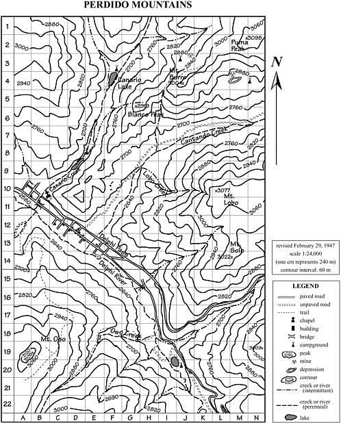
8 Help! Mr. Searles got lost on his way to school! (Before GPS, this could have been a true story) Directions: Follow the directions below. At each step, make a dot. Connect the dots in order to create your map. 1. Make a star at the chapel, located at the north end of town. 2. Follow Canario Creek 1.7 km up-stream to Canario Lake. 3. Walk north along the western shore of Canario Lake to a campground. 4. At the camp, follow Canario Creek up-stream from the lake until you are due west of Puma Peak, a mountain in the chain to the east. 5. Turn east, cross Canario Creek, and climb 300 m in elevation. 6. Keeping your elevation at 300m, head southwest to Mount Burro. 7. From Mount Burro, look for the campground on the shallow slope to the east and walk down to it. 8. Head south from the campground to Cantando Creek. 9. Follow Cantando Creek downstream to a stream bed entering the creek from a canyon to the southeast (Lobo Creek). 10. Follow Lobo Creek up the canyon to an elevation 360 m above Cantando. 11. Follow the contour to the south and east until you are directly between two peaks, Mount Lobo and Mount Solo. 12. You found Mr. Searles! Mark his location with an X Important Map Information: 1. Carefully review the map below. Familiarize yourself with the scale and the legend. 2. The numbers and letters along the edges of the map are used to locate features on the map. For example, there is a chapel located in B Note that the contour interval for the map is 60 m. 8
9 9

10 INDEPENDENT PRACTICE Directions: For each key term, explain the big idea to a kindergartener. Then, draw a picture to illustrate the word. Term Concept Picture Contour Intervals Elevation Slope 10
11 Directions: Read and ANNOTATE each question before you solve the problem. 11
12 1. What is the elevation in meters of point X? 2. What is the elevation in meters of point Y? 3. What is the elevation in meters of point Z? 4. What is the difference in elevation in meters between points X and Y? Contour Interval: 20 m 5. What is the difference in elevation in meters between point Y and the highest point on this landform? 6. What is the difference in elevation in meters between points X and Z? Contour Interval: 20 m 7. What is the elevation in meters of point A? 8. What is the elevation in meters of point B? 9. What is the elevation in meters of point C? 10. What is the difference in meters between the two points labeled A and C? 12
13 13
14 14

15 Science 8 Name: SKILL SNAPSHOT Date: ES.15: Topographic Maps Homeroom: Quick Notes: Read and ANNOTATE the information before you solve the problem. Like A Scholar? Yes No Redo? Yes No 1. State the general compass direction in which the stream is flowing in the given map. State how contour lines provide the evidence for determining this direction. 2. Some hikers have decided to climb the mountain on the map. Should they start at Point P or Point Q for the easiest climb? State how the contour lines provide evidence for your suggestion. 15

16 Imagine you are taking a hike through a national park. The park ranger gives you a topographic map to help you find your way. Use the map below to answer the following questions. 3. At what end of the park is the ranger s station? 4. What is in the northwest corner of the park? 5. How many trees are in the park? 6. At what elevation is the ranger s station? 7. At what elevation is the bridge? 8. How many cabins are at or above an elevation of 750 m? 9. How high is the highest point in the park? 10. The river has eroded away some of the soil. Which way is the river flowing? How do you know? 16
A topographic map shows:,,,,
 Name: Period: Mapping the Earth Notes What is a map? Label the compass directions: What does latitude measure? What is the name of the 0 latitude line? Where is 90 north latitude? Where is 90 south latitude?
Figure 1 Understanding Map Contours
 Figure 1 Understanding Map Contours The light brown lines overprinted on topographic maps are called contour lines. They indicate the elevation above sea level of land features and thus permit you to view
MiSP Topographic Maps Worksheet #1a SLOPE AND TOPOGRAPHIC CONTOURS
 MiSP Topographic Maps Worksheet #1a Name Date Introduction: SLOPE AND TOPOGRAPHIC CONTOURS Topographic contours are shown by lines of different widths. Each contour is a line of equal elevation; therefore,
MiSP Topographic Maps Worksheet #1a L2
 MiSP Topographic Maps Worksheet #1a L2 Name Date SLOPE AND TOPOGRAPHIC CONTOURS Introduction: Topographic contours are shown by lines of different widths. Each contour is a line of equal elevation; therefore,
Introduction to Topographic Maps
 Introduction to Topographic Maps DIRECTIONS: Read all of the following content. READ EVERYTHING!! At the end of the packet, you will find two topographic maps. Your task is to indentify each of the elevations
Camp Jack Wright PERMANENT ORIENTEERING COURSE (2004)
") Camp Jack Wright PERMANENT ORIENTEERING COURSE (2004) WHAT IS ORIENTEERING? The skill which enables a person to navigate with a map. In the competitive sport, the winner is the person who finishes in the
Camp Jack Wright PERMANENT ORIENTEERING COURSE (2004) WHAT IS ORIENTEERING? The skill which enables a person to navigate with a map. In the competitive sport, the winner is the person who finishes in the
Tooling Around Arizona Use Arizona Cities Map (with or without compass rose) Measuring Distances
 Measuring Distances") Name Tooling Around Arizona Use Arizona Cities Map (with or without compass rose) Measuring Distances Directions: Using the scale on the Arizona Cities Map, measure the distances between the following
Name Tooling Around Arizona Use Arizona Cities Map (with or without compass rose) Measuring Distances Directions: Using the scale on the Arizona Cities Map, measure the distances between the following
Topographic Maps. Background Sheet
 Topographic Maps History: Background heet The Articles of Confederation (1777) was ratified when western lands were yielded to the Federal Government. This yielding of land gave the Federal Government
EXPLORING EARTH S SURFACE. Lesson 4
 EXPLORING EARTH S SURFACE Lesson 4 Introduction Lewis and Clark In 1804, an expedition set out from near Saint Louis to explore the land between the Mississippi River and the Pacific Ocean, The United
c. 1 inch = 0.6 miles e. 1:100,000 f. 1:250,000 f. 1 inch = 4.0 miles
 High School Advance Geology Map Test 2014 Name Use the information on each map to provide the best answer to the questions. Fill in the bubble of the best answer on your answer sheet. Answer questions
Map & Compass so easy a caveman can do it!
 Map & Compass so easy a caveman can do it! Compass Basics Opening Comments Terms of a compass Boxing a needle Get a bearing (you to a point) Get a bearing (a point to you) Orienting a map Get a bearing
INTERPRETING TOPOGRAPHIC MAPS (MODIFIED FOR ADEED)
") INTERPRETING TOPOGRAPHIC MAPS (MODIFIED FOR ADEED) Science Concept: Topographic maps give information about the forces that shape the features of Earth. Objectives: The student will: identify land features
INTERPRETING TOPOGRAPHIC MAPS (MODIFIED FOR ADEED) Science Concept: Topographic maps give information about the forces that shape the features of Earth. Objectives: The student will: identify land features
Road Scholar Gopher Science Olympiad Invitational January 6, Team #: Team Name: Names: Score:
 Road Scholar Gopher Science Olympiad Invitational January 6, 2018 Team #: Team Name: Names: Score: Welcome to Road Scholar! Your Science Olympiad team is planning a trip to an invitational tournament in
Topographic Maps. Practice Packet. Block: Name:
 Topographic Maps Practice Packet Name: _ Block: _ / Map Elevation Exercise Identify the elevation of each point identified on the map above. A:, D: ----- _ B: _ E: _ G: ----- B: ----- c: _ F: _ Identify
County Line trail - Miller Peak to Little Navaho
 County Line trail - Miller Peak to Little Navaho 7-17-2008 This hike features a portion of the County Line trail in the Teanaway that receives extremely little use despite offering a spectacular ridge-run
Crystal Lake Area Trails
 Lake Area Trails Welcome to the Lake area of the Big Snowy Mountains! This island mountain range in central Montana features peaks reaching to 8,600 feet and long, high ridges from which vistas of the
Oregon Section C - Page 1 WGS84 Zone 10T m
 00 N. 99 N. 98 N. 97 N. 96 N. 557000m Oregon Section C - 74.4 miles Start - Hwy 140, mile 1773.4 (near Fish Lake) End - Hwy 138, mile 1847.8 (near Cascade crest) Elevation Gain +8,111' Elevation Loss -7,145'
Route #1) Mt. of the Holy Cross - North Ridge
 Mt. of the Holy Cross - North Ridge") Climbing 14ers can be very dangerous, please read the Mountaineering Safety Page and make sure you have a map+compass and can use them effectively, without the help of electronic devices. Route #1) Mt.
Climbing 14ers can be very dangerous, please read the Mountaineering Safety Page and make sure you have a map+compass and can use them effectively, without the help of electronic devices. Route #1) Mt.
GIFFORD PINCHOT NATIONAL FOREST
 GIFFORD PINCHOT NATIONAL FOREST 9341 Wright Meadow 93 Spencer Meadow Spencer Butte 4247' 30 30A 19 24 80 31C Lewis River Lower Falls 5 Quartz Creek 90 Taidnapam Falls Upper Falls 31 Spencer Peak 3861'
White Mountain Wilderness Trails
 The area in which these hikes are located is rugged high mountain country along the Mogollon Rim. This famous eastwest escarpment separates Arizona's high plateau from the basin and range below. These
CWH Posting Your Own Hikes
 Posting Your Own Hikes and Making Changes to these Hike Listings POSTING YOUR OWN HIKES Welcome to Posting Your Own Hikes on the Calgary Weekenders Hikers website. This document will walk you through posting
Looking back across Emerald Lake at Wapta Mountain (on the left) and Mount Burgess (on the right):
 and Mount Burgess (on the right):") YOHO LAKE FROM EMERALD LAKE, YOHO NATIONAL PARK, BRITISH COLUMBIA, CANADA We decided to hike to Yoho Lake from Emerald Lake even though the distance is longer than the trail from Takakkaw Falls (about
YOHO LAKE FROM EMERALD LAKE, YOHO NATIONAL PARK, BRITISH COLUMBIA, CANADA We decided to hike to Yoho Lake from Emerald Lake even though the distance is longer than the trail from Takakkaw Falls (about
Hey Little Buddy, It s Nussbaum s Island
 Hey Little Buddy, It s Nussbaum s Island What began as a three-hour plane tour over the Pacific Ocean, ended up as an adventure. I m Nussbaum and let me tell you about my island. The island is located
Unit 7 Lesson 4 : Topographic Maps
 Unit 7 Lesson 4 : Topographic Maps Edit File Screen 1 - W elcom e PRI OR KNOWLEDGE W hy do people use m aps? People use m aps to see where they are and to find out how to get where they want to go. For
Below is an example of a well laid-out template of a route card used by the Sionnach Team which is a good format to begin with.
 Route Card A route card is used as a navigational aid to hill walkers by setting out a step by step plan for an intended hike. It is good practice to make out a route card before every hike you or your
MIDDLE SCHOOL CURRICULUM TR AILING ICE AGE M YST ERI E S SEARCHING GLACIAL FEATURES
 MIDDLE SCHOOL CURRICULUM TR AILING ICE AGE M YST ERI E S SEARCHING GLACIAL FEATURES CONTENTS I. Enduring Knowledge... 3 II. Teacher Background... 3 III. Before Viewing the Video... 5 IV. Viewing Guide...
GC 225 Lecture Exam #2
 GC 225 Lecture Exam #2 Direction- path along which something is moving. 3 Types; - COMPASS DIRECTIONAL NAME (32 in total) - BEARING (four 0 o - 90 o ) - AZIMUTHS (0 o - 360 o ) Compass (32 named points)
Travel A dv en tur es: The Gr and C an yon Data A nderson Rane Anderson
 Data Rane Anderson Table of Contents The Grand Canyon...4 The Journey Down...6 A Canyon Is Carved...10 Rock Stars, Rock Groups...14 Prehistoric Preserves...21 A Grand Trip...26 Problem Solving...28 Glossary...30
SLOPE CALCULATION. Wilderness Trekking School 1
 SLOPE CALCULATION By Joe Griffith, February 2014 Objectives Upon completion of this chapter, you will be able to: Read the rise-over-run from a topographic map. Convert the rise-over-run into a slope angle
Topo Map Explorer. Adapted from: An original Creek Connections activity. Creek Connections, Box E, Allegheny College, Meadville, Pennsylvania, 16335
 Topo Map Explorer Adapted from: An original Creek Connections activity. Creek Connections, Box E, Allegheny College, Meadville, Pennsylvania, 16335 Review of major topographic map concepts Grade Level:
Marble: 7:09 am Creede: 1:01 pm Today s Airtime: 5.8 hrs Cartographic length 351 miles. Total PIC Time: Total Logged Time 1623.
 Monday, September 11, 2017 Cobra flight #600, PIC #613, 1 landings Misty Meadows, Clear Creek Falls, Lost Lakes, Ute Ridge, Silex, Rio Grande Pyramid, Hossick Lake, Pagosa Peak, Chama Headwaters and Falls,
CIEC 9 PEAKS AWARD SUPPLEMENT POSSIBLE ROUTES FOR THE 9 PEAKS AWARD TRIP
 CIEC 9 PEAKS AWARD SUPPLEMENT POSSIBLE ROUTES FOR THE 9 PEAKS AWARD TRIP As you plan your trip, be aware of 3 regulations in this wilderness: 1. Camp only in designated campsites. 2. No campfires allowed.
Glacier Day Hikes: Now With GPS Compatible Maps By Alan Leftridge READ ONLINE
 Glacier Day Hikes: Now With GPS Compatible Maps By Alan Leftridge READ ONLINE GLIMS: Progress in Mapping the World's Glaciers - GLIMS: Global. Glacier Day Hikes: Now With GPS Compatible Maps kamo97.net.
Activity: Global Tourism
 ACTIVITY 26: GLOBAL TOURISM 1 CGG3O Travel & Tourism Name: Oxford Canadian School Atlas 9 th edition On the Road Again Activity: Global Tourism How many times have you been watching television, reading
Shenandoah National Park (National Geographic Trails Illustrated Map) PDF
 PDF") Shenandoah National Park (National Geographic Trails Illustrated Map) PDF â Waterproof â Tear-Resistant â Topographic MapExpertly researched and created in partnership with local land management agencies,
Shenandoah National Park (National Geographic Trails Illustrated Map) PDF â Waterproof â Tear-Resistant â Topographic MapExpertly researched and created in partnership with local land management agencies,
Hiking/ Trekking. Vocabulary. Kontakt
 Hiking/ Trekking Vocabulary altitude sickness - an illness caused from being at high elevations a canteen - a container used for carrying drinking water dehydration - a physical condition caused by not
Route #2) Mt. Massive - Southwest Slopes
 Mt. Massive - Southwest Slopes") Route #2) Mt. Massive - Southwest Slopes Difficulty: Class 2 Ski: Advanced, D6 / R2 / III Exposure: Summit Elevation: Trailhead Elevation: Elevation Gain: Round-trip Length: Trailhead: County Sheriff:
Route #2) Mt. Massive - Southwest Slopes Difficulty: Class 2 Ski: Advanced, D6 / R2 / III Exposure: Summit Elevation: Trailhead Elevation: Elevation Gain: Round-trip Length: Trailhead: County Sheriff:
The temperature is nice at this time of year, but water is already starting to be scarce.
 In March of 2003, Scott Morrison and I went backpacking in the Grand Canyon. The temperature is nice at this time of year, but water is already starting to be scarce. Another issue with this time of year
Kennesaw Mountain Trail Club. Trail Skills Workshop ~ Dips and Drains. Presented by: Jay M Dement
 Kennesaw Mountain Trail Club Trail Skills Workshop ~ Dips and Drains Presented by: Jay M Dement KEY CONCEPTS: Control Erosion and Users Where Do Trails Come From, and How Do They Work: Concept of trail
Alpine Glacial Features along the Chimney Pond Trail, Baxter State Park, Maine
 Maine Geologic Facts and Localities September, 2009 Alpine Glacial Features along the Chimney Pond Trail, Baxter State Park, Maine 45 54 57.98 N, 68 54 41.48 W Text by Robert A. Johnston, Department of
Mapping the Snout. Subjects. Skills. Materials
 Subjects Mapping the Snout science math physical education Skills measuring cooperative action inferring map reading data interpretation questioning Materials - rulers - Mapping the Snout outline map and
Massanutten Mountain Cluster
 Massanutten Mountain Cluster Signal Knob Catback Mountain Southern Massanutten Mountain Five areas of almost 49,000 acres on the Lee Ranger District compose the Massanutten Mountain Cluster of Mountain
Rogue Gorge (Mt. Stella) Roadless Area-- T30S R3E (primarily in portions of Sections 23, 26, 33, 34 & 35)
 Roadless Area-- T30S R3E (primarily in portions of Sections 23, 26, 33, 34 & 35)") Rogue Gorge (Mt. Stella) Roadless Area-- T30S R3E (primarily in portions of Sections 23, 26, 33, 34 & 35) Rogue River-Siskiyou National Forest--High Cascades Ranger District Upper, higher elevation trail
Rogue Gorge (Mt. Stella) Roadless Area-- T30S R3E (primarily in portions of Sections 23, 26, 33, 34 & 35) Rogue River-Siskiyou National Forest--High Cascades Ranger District Upper, higher elevation trail
READING QUESTIONS: Chapter 7, Glaciers GEOL 131 Fall pts. a. Alpine Ice from larger ice masses flowing through a valley to the ocean
 READING QUESTIONS: Chapter 7, Glaciers GEOL 131 Fall 2018 63 pts NAME DUE: Tuesday, October 23 Glaciers: A Part of Two Basic Cycles (p. 192-195) 1. Match each type of glacier to its description: (2 pts)
IMPORTANT DEFINITIONS DEFINITIONS FROM TOPO MAPS
 IMPORTANT DEFINITIONS DEFINITIONS FROM TOPO MAPS 1. REPRESENTATIVE FRACTION (RF): It is the ratio between the distances on the map to its corresponding distance on actual ground. The RF on this map is
FINAL STAG E : 5 T H G R A D E
 NAME COURSE SURNAME CENTRE YOUR TEACHER S NAME FINAL STAG E : 5 T H G R A D E 1. Read Danny s diary and complete his timetable. Remember there are extra words! EXTINCT / WATERFALL / VALLEY / PATH / WOOD
MIDDLE SCHOOL CURRICULUM TR AILING ICE AGE M YST ERI E S ICE AGE TREKKING
 MIDDLE SCHOOL CURRICULUM TR AILING ICE AGE M YST ERI E S ICE AGE TREKKING CONTENTS I. Enduring Knowledge... 3 II. Teacher Background... 3 III. Before Viewing this Video... 5 IV. Viewing Guide... 5 V. Discussion
2012 Oregon State Science Olympiad. B-Division Road Scholar Event National Wildlife Refuge Site Selection. Student Participants:
 2012 Oregon State Science Olympiad B-Division Road Scholar Event National Wildlife Refuge Site Selection Student Participants: School/Team: To answer the questions you will need a pencil, ruler, protractor,
Trail Beginning Elevation: 7553 ft The Poison Creek Trailhead is located at the end of National Forest Road 646E (NF-646E).
.") West Mountain Trails Poison Creek Trail #134 Length: 2.9 miles (4.7 km) Difficulty Horseback: A good trail for the first time west mountain rider, some steep sections Hiking: Most Difficult USGS Maps:
West Mountain Trails Poison Creek Trail #134 Length: 2.9 miles (4.7 km) Difficulty Horseback: A good trail for the first time west mountain rider, some steep sections Hiking: Most Difficult USGS Maps:
155 acres on Tyaughton Lake 900 feet of Pristine Waterfront Private & Secluded Property
 155 acres on Tyaughton Lake 900 feet of Pristine Waterfront Private & Secluded Property 946 Tyaughton Lake Road Gold Bridge BC V0K1P0 900 ft of waterfront with 155 acres of south facing easy access. This
Geocaching at the Klondike 2014
 Geocaching at the Klondike 2014 What is a Geocache? What do they typically look like? What is Geocaching? What is a GPS? How does a GPS work? What does Geocaching have to do with scouting? How many geocaches
Camp Geronimo Rainbow Trails
 Camp Geronimo Rainbow Trails With over 5,000 acres of surrounding national forest, the possibilities of getting out and seeing the wilderness are almost limitless. Camp Geronimo offers some of the greatest
Answers to Your Turn. Chapter 2. Maps and mapping
 Geog. 1 Answers to Your Turn Chapter 2. Maps and mapping Chapter 2.1 Mapping connections 1. A = Isle of Man; B = Northumberland; C = Cornwall; D = Surrey; E = Shrewsbury; F = Nigeria; G = Japan; H = China;
VAST Challenge 2017 Reviewer Guide: Mini-Challenge 1
 VAST Challenge 2017 Reviewer Guide: Mini-Challenge 1 This document provides information to support peer review of submissions to VAST Challenge 2017, Mini-Challenge 1. It covers background about the submission
Social Studies: The World
 Social Studies: The World What is the name of the continent that is labeled #1 on the map? North America What is the name of the continent that is labeled #2 on the map? South America What is the name
Royal Gorge Far Out Trail to Le Point
 Royal Gorge Far Out Trail to Le Point Direction to trailhead: From East Ridge Campground: Drive west from Canon City on US 50 to County Road 3A, the entrance road to the Royal Gorge Park. Turn left onto
LESSON 5 Wilderness Management Case Studies
 LESSON 5 Wilderness Management Case Studies Objectives: Students will: review the key points of the Wilderness Act of 1964. brainstorm solutions for Wilderness management issues. Materials: Í Leave no
Morning Star Peak Avalanche Accident
 Morning Star Peak Avalanche Accident Saturday, December 4, 2010 Date: 2010-12-13 Submitted by: Oyvind Henningsen Everett Mountain Rescue and Mark Moore NWAC Place: Morning Star Peak, north-central WA Cascades
Geomorphology. Glacial Flow and Reconstruction
 Geomorphology Glacial Flow and Reconstruction We will use simple mathematical models to understand ice dynamics, recreate a profile of the Laurentide ice sheet, and determine the climate change of the
ANGEL PEAK SCENIC AREA
 Activities: Facilities: ANGEL PEAK SCENIC AREA Hiking, photography, watchable wildlife, camping, picnicking. Note: While formal hiking trails in the area are limited, dispersed hiking opportunities abound
Appendix I Case-Studies in Wilderness Management
 Appendix I Case-Studies in Wilderness Management Management Issue Scenarios Note: These scenarios are meant to be used as guidelines for the program leader rather than to be read verbatim. Introduce a
Skyline Drive Hogback Canon City
 Skyline Drive Hogback Canon City Direction to trailhead: From US 50, turn north onto 15th Street. At the traffic circle, continue north on 15th Street until it dead ends at Washington Street (about 1.5
Isle Royale Info Section 5: Campgrounds
 Isle Royale Info Section 5: Campgrounds Overview: All of the campgrounds are very well marked and the sites have shelters and or tent pads. Shelters are typically available at campgrounds on Lake Superior,
Kindergarten Science Unit C: Earth Science Chapter 5: Our Land, Air, and Water Lesson 1: What makes up the Earth?
 Insert Photo or Graphic for Unit or Lesson Theme Kindergarten Science Unit C: Earth Science Chapter 5: Our Land, Air, and Water Lesson 1: What makes up the Earth? Insert Photo/Graphic Earth Insert Photo/Graphic
Hydraulic Report. Trail 5 Snowmobile Trail Over Mulligan Creek. Prepared By: COLEMAN ENGINEERING COMPANY Karisa V. Falls, P.E.
 Prepared for: Prepared by: Marquette County Road Commission Coleman Engineering Company Marquette, Michigan Iron Mountain, MI December 2011 Hydraulic Report Trail 5 Snowmobile Trail Over Mulligan Creek
San Luis Obispo. Bishop Peak Felsman Loop Eagle Rock Maino Open Space Poly Canyon Poly P Other Areas
 San Luis Obispo Bishop Peak Felsman Loop Eagle Rock Maino Open Space Poly Canyon Poly P Other Areas 1 JCT. ELEV. 72 400 00 0 FELSMAN LOOP GATE LOOP RIDGE 600 FENCE JCT. ELEV. 860 1000 1200 BISHOP PEAK
1. Study the Ordnance Survey Map of Brodick, Isle of Arran.
 1. Study the Ordnance Survey Map of Brodick, Isle of Arran. To find the map go to: > http://www.bing.com/maps/ > change maps type to Ordnance Survey Map from Road. > search for Glenrosa Water (it is near
Computer Simulation for Evaluating Visitor Conflicts
 Computer Simulation for Evaluating Visitor Conflicts Why use Simulation? To acquire a comprehensive and dynamic understanding of visitor behavior and their interactions across the landscape (space and
CONTRIBUTOR REWARDS PROGRAM
 CONTRIBUTOR REWARDS PROGRAM Here s how it works... Document + submit an adventure Earn Adventure Points (AP) when it s published Get rewards: awards, prizes, pro deals + earn cash Page Document + submit
Friday October 3. Lower Javelina Trail - Level D. about 3 miles, less than 500. Hike Contact: Joel Tormoen
 Friday October 3 Lower Javelina Trail - Level D. about 3 miles, less than 500 Hike Contact: Joel Tormoen joeltormoen@gmail.com Depart WB trailhead 8:00 am - return before 11:00 am This quite easy hike
Ranger Award Core Requirements
 Ranger Award Core Requirements CORE REQUIREMENTS Do all of the following core requirements. 1. First Aid Complete a standard first aid course plus the American Red Cross When Help Is Delayed module or
White-water rafting on the Colorado River through Granite Gorge
 Read Sections 3 to 5. After reading each section, you will create an adventure tour for that park. A tour plan for the Grand Canyon is shown here as an example. It includes a map showing the route the
Photographic Log Client: Project Number: Site Location: Site Name: Photograph ID: Date: Location: Direction: Comments: Photograph ID:
 Photograph ID: 1 west View of one of the monitoring well and the large parking lot on the south side of Center Street. Photograph ID: 2 Monitoring well located in the middle of the parking lot located
Camping Narrative. In part 2, you will need to write a story using the sources you have read.
 Camping Narrative Your Assignment: A camping club wants to publish a collection of stories about camping. The club leaders have asked for people to learn about camping and to send in stories about camping.
Outdoor Education in Montgomery County
 Outdoor Education in Montgomery County Nothing is real until it is experienced Providing opportunities for all students in Montgomery County to engage in authentic learning outside of the four walls of
Individual Unit Unit Overview
 Molly Larson Individual Unit Unit Overview Big Idea: What makes Duluth special? Grade: First Time: Day One: Approximately 55 minutes Day Two: Approximately 55 minutes Day Three: Approximately 55 minutes
Trail Phasing Plan. Note: Trails in the Clear Creek Canyon area (Segments will be finalized in the future to minimize wildlife impacts
 Note: Trails in the Clear Creek Canyon area (Segments 2 5 and a future JCOS connection) will be finalized in the future to minimize wildlife impacts Trail Phasing Plan P Parking 3 Easy Trail Intermediate
Yellowstone Lake: Yellowstone National Park SE (National Geographic Trails Illustrated Map) By National Geographic Maps - Trails Illustrated
 By National Geographic Maps - Trails Illustrated") Yellowstone Lake: Yellowstone National Park SE (National Geographic Trails Illustrated Map) By National Geographic Maps - Trails Illustrated Yellowstone National Park - National Geographic - Trail Maps.
Yellowstone Lake: Yellowstone National Park SE (National Geographic Trails Illustrated Map) By National Geographic Maps - Trails Illustrated Yellowstone National Park - National Geographic - Trail Maps.
One Way. Lesson , 3 6 5
 Name Interpret the Remainder Essential Question When solving a division problem, when do you write the remainder as a fraction? Lesson 2.7 Number and Operations Fractions 5.NF.B.3 Also 5.NBT.B.6 MATHEMATICAL
Interactive Science Notebook. Earth Cycles
 Interactive Science Notebook Earth Cycles Please contact me with any questions, concerns, or thoughts at glitterinthird@gmail.com. I hope you and your students love this product! Stay connected! Blog:
12: MELTWATER LANDFORM IDENTIFICATION
 Glacial Geology 12. Meltwater Landform Identification 12: MELTWATER LANDFORM IDENTIFICATION 60 Points Objective: learn how to identify meltwater landforms and their characteristics in photos and on topographic
Climbing Oak and Brushy Top Mountains
 Climbing Oak and Brushy Top Mountains Story and photographs by Vann Helms www.blueridgeimpressions.org Brushy Top Mountain- February 2, 2014 Brushy top summit After a January of record breaking cold weather,
Table 1: Santiago Peak Communication Site. Latitude 1 Longitude 1 Elev 2 Address T/R/S 3 APN 4 USGS Quadrangle
 County of Riverside Public Safety Enterprise Communication Project Appendix A: Candidate Site Descriptions Overview The site is located in the Cleveland National Forest (CNF) at an existing communication
playwinterpark.com Off The Beaten Path Hikes Hiking Recommendations for the Adventurous Hiker
 playwinterpark.com Off The Beaten Path Hikes Hiking Recommendations for the Adventurous Hiker Hike: Devil s Thumb (difficult) Length: 3.93 miles one-way Elevation: Trailhead 9609 Destination 12,236 Trailhead
Historic Highway Advisory Committee To Meet in The Dalles
 In This Issue Get Involved Highway Gets Major Endorsement New Life for the Old Road Bike Pods and Hubs Time Travel on the Historic Highway Gorge Ride 2014 The Historic Columbia River Highway News is your
Using Drakensberg maps in Basecamp
 Using Drakensberg maps in Basecamp Below are a few of the functions that are specific to a map that you might find handy within Basecamp. People using Mapsource for older units should be able to do much
Roller Coasters! PRE READING TASK. Physics Gr11A
 Name: Class: Date: Roller Coasters! Grade 11A Science Related Reading/Physics Physics Gr11A A cat jumps over a fence. How does the dog s potential energy change on the way up? How does the dog s potential
02-10 June 2015 Round-the-World Trip: Canadian Rockies. Dear Friends,
 Dear Friends, Here is another chapter of our adventures. Few days after my return from California, we went on a 4-day trip to the Canadian Rockies with Louise, Nasser and Leah. After that we continued
Note: Coordinates are provided as Universal Transverse Mercator UTM Zone U21, North American Datum 1983 (NAD 83).
.") Northern Traverse Route Description The Northern Traverse (formerly the North Rim Traverse) is an unmarked and rugged backcountry hiking route. It is known be a demanding hike, because of its terrain and
Northern Traverse Route Description The Northern Traverse (formerly the North Rim Traverse) is an unmarked and rugged backcountry hiking route. It is known be a demanding hike, because of its terrain and
Glacier National Park
 Glacier National Park West Glacier, MO Page 1 Page 3-6 Report Rough Draft Glacier National Park Glacier National Park is located in the northwest corner of Montana and extends into Canada. It is located
READING QUESTIONS: Glaciers GEOL /WI 60 pts. a. Alpine Ice from larger ice masses flowing through a valley to the ocean
 READING QUESTIONS: Glaciers GEOL 131 18/WI 60 pts NAME DUE: Tuesday, March 13 Glaciers: A Part of Two Basic Cycles (p. 192-195) 1. Match each type of glacier to its description: (2 pts) a. Alpine Ice from
Tarryall Mountains, Kenosha Pass (National Geographic Trails Illustrated Map) By National Geographic Maps - Trails Illustrated
 By National Geographic Maps - Trails Illustrated") Tarryall Mountains, Kenosha Pass (National Geographic Trails Illustrated Map) By National Geographic Maps - Trails Illustrated PUBLIC - Lost Creek Trails Home - The area is situated entirely within the
Tarryall Mountains, Kenosha Pass (National Geographic Trails Illustrated Map) By National Geographic Maps - Trails Illustrated PUBLIC - Lost Creek Trails Home - The area is situated entirely within the
Death Valley National Park Wilderness/Backcountry Users Visitor Study
 Social Science Program National Park Service U.S. Department of the Interior Visitor Services Project Death Valley National Park Wilderness/Backcountry Users Visitor Study 2 Death Valley National Park
USDA Trails Strategy WRI: ENGLISH PEAK SURVEY. Theodore Mendoza San Diego State University June 6 th 2016 August 18 th Advisor: Sam Commarto
 WRI: ENGLISH PEAK SURVEY Theodore Mendoza San Diego State University June 6 th 2016 August 18 th 2016 Advisor: Sam Commarto Klamath National Forest Submitted: March 21, 2017 Table of Contents Acknowledgements
HOBART AIRSPACE DESIGN
 HOBART AIRSPACE DESIGN CARLTON COMMUNITY Airservices has undertaken a review of the Hobart Airport Standard Instrument Departures (SIDs) and Standard Instrument Arrivals (STARs) for Runway 12 and Runway
Plate III C-l. LODGES, INNS, AND HOTELS Hi- Greylock Slate Reservation, Massachusetts
 LODGES, INNS, AND HOTELS Hi- Plate III C-l Greylock Slate Reservation, Massachusetts In this lodge structure on the summit of Mount Greylock, stone is utilized for the walls of the approach side and more
1 Glacial Erosion and
 www.ck12.org Chapter 1. Glacial Erosion and Deposition CHAPTER 1 Glacial Erosion and Deposition Lesson Objectives Discuss the different erosional features formed by alpine glaciers. Describe the processes
Great Science Adventures
 Great Science Adventures Lesson 18 How do glaciers affect the land? Lithosphere Concepts: There are two kinds of glaciers: valley glaciers which form in high mountain valleys, and continental glaciers
LAKE NEEDWOOD ORIENTEERING MEET QUANTICO ORIENTEERING CLUB SEPTEMBER 18, 2011
 NATIONAL ORIENTEERING DAY LAKE NEEDWOOD ORIENTEERING MEET QUANTICO ORIENTEERING CLUB SEPTEMBER 18, 2011 COMBINED EVENT NOTES, including: National Orienteering Day Course Designer s Notes Super String-O
Instructions with pictures of completed
 Rocky Mountain States Lapbook Instructions Print state matchbooks two sided (flip along the long side of the paper) Print Rocky Mountain State features two sided (flip along the long side of the paper).